Conway Elementary School
|
|
|
- Lucinda Wheeler
- 5 years ago
- Views:
Transcription


1 Conway Elementary School Safe Routes to School Travel Plan February 2012 Prepared with assistance from the SC SRTS Resource Center
2 INTRODUCTION This Travel Plan represents the work of the Conway Elementary School Safe Routes to School Team. Conway Elementary School (Conway Elementary) is a Bronze Level partner with the South Carolina Safe Routes to School (SRTS) Resource Center. We believe that developing a travel plan that outlines the issues and solutions to getting more students to walk and bike to school is a good way to ensure a successful SRTS program at our school. The ideas and recommendations developed during this process will guide us in creating a well-balanced approach to building our SRTS program at Conway Elementary. Our school team will use this document as a resource to plan our encouragement, education, enforcement, and evaluation efforts with assistance from the SC SRTS Resource Center. The plan also includes recommendations for engineering projects near Conway Elementary that would have a positive impact on walking and biking to school. It is our hope that our recommendations can be the basis for grants and/or improvements initiated by the City of Conway or Horry County. A diverse SRTS team consisting of school administrators, teachers, and other community stakeholders was organized and provided input, guidance and oversight in writing our plan. SCDOT, through the South Carolina SRTS Resource Center, has provided technical assistance in producing this plan. We recognize that SCDOT has reviewed this plan but that the review does not imply formal adoption of the plan by the SCDOT or funding of the recommendations. The Five E s SRTS combines many different approaches to make it safer for children to walk and bicycle to school and to increase the number of children doing so. Engineering strategies create safer environments for walking and bicycling to school through improvements to the infrastructure surrounding schools. These improvements focus on reducing motor vehicle speeds and conflicts with pedestrians and bicyclists, and establishing safer and fully accessible crossings, walkways, trails and bikeways. Education programs target children, parents, caregivers and neighbors, teaching how to walk and bicycle safely and informing drivers on how to drive more safely around pedestrians and bicyclists. Education programs can also incorporate health and environment messages. Enforcement strategies increase the safety of children bicycling and walking to school by helping to change unsafe behaviors of drivers, as well as pedestrians and bicyclists. A community approach to enforcement involves students, parents or caregivers, school personnel, crossing guards and law enforcement officers. Encouragement activities promote walking and bicycling to school to children, parents and community members. Events such as Walk to School Day, contests such as a Frequent Walker/Bicyclist challenge, or ongoing programs such as a Walking School Bus or Bicycle Train can promote and encourage walking and bicycling as a popular way to get to school. Evaluation is an important component of SRTS programs that can be incorporated into each of the other E s. Collecting information before and after program activities or projects are implemented allow communities to track progress and outcomes, and provide information to guide program development. - Excerpted from Safe Routes to School: A Transportation Legacy, the report of the National Safe Routes to School Task Force
3 Members of the Conway Elementary Travel Plan Team Maquitta J. Davis Principal Conway Elementary School Shannon McAlister Physical Education Teacher Conway Elementary School Jim Wright Director of Transportation Horry County School District Mark Hoeweler Assistant Executive Director Waccamaw Regional Council of Governments Reginald E. Gosnell Chief of Police City of Conway Michael Leinwand Planning Director City of Conway Jennifer Maddox Chronic Disease Manager SC Department of Health and Environmental Control Chris Clark Transportation Planner Waccamaw Regional Council of Governments TEAM VISION The Safe Routes to School (SRTS) program at Conway Elementary aligns with the community s efforts to promote wellness and safety. Our vision for Conway Elementary includes the following goals: - Students develop pedestrian safety and bicycle safety skills that they can apply throughout their lives - Parents clearly understand and follow expectations and procedures related to arrival and dismissal - Drivers are cognizant and supportive of student pedestrians and bicyclists and adjust their behavior accordingly to ensure safety for all road users - Congestion near the school is reduced This SRTS Travel Plan outlines our school s intentions for making walking to and from school safer and more sustainable for students and the community. Through our SRTS program and
4 efforts, we hope to reach a rate of 15% of our students walking or biking to school at least two days a week. We believe this goal is attainable, as 25% of our students live within 1 mile of school. ABOUT THIS PLAN The Conway Elementary SRTS Team met three times with staff from the South Carolina SRTS Resource Center to develop this SRTS plan. Each meeting provided education on the benefits of SRTS and highlighted successful program components and strategies. The engineering meeting included a guided walk audit of the areas around our school. We also discussed education, encouragement, enforcement, and evaluation strategies, which helped us to identify needed and complimentary programs to support proposed engineering strategies. An overview of our preliminary process is included in the table below. Meeting Date September 2011 October 2011 December 2011 Content and Outcomes Kick-off Meeting: How the SC SRTS Travel Plan Works - Award of the planning assistance grant - Overview of the planning process Engineering Meeting - Team visioning - Opportunity and barrier discussions - Walk audit and dismissal observation Plan Review - Reviewed the draft plan - Identified roles and immediate steps for non-engineering recommendations

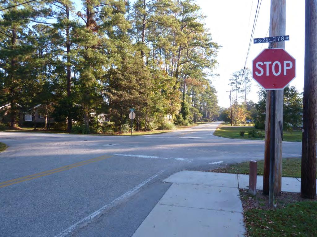
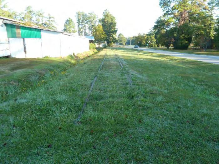
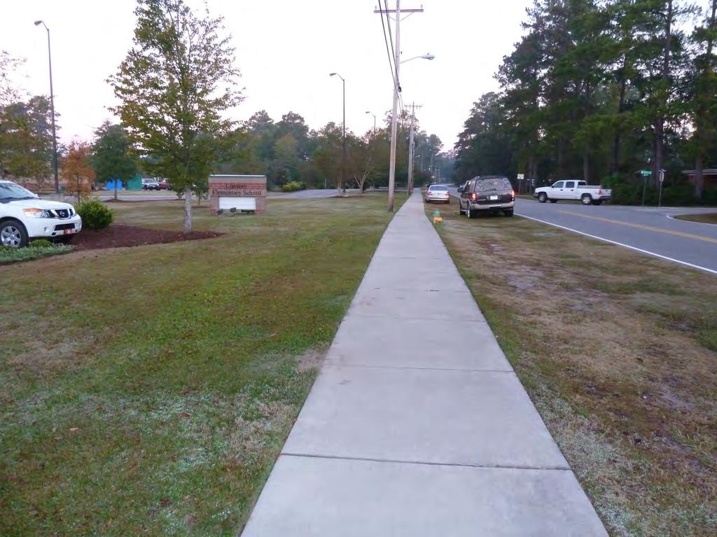
5 TRAVEL PLAN CONTEXT OVERVIEW OF CONWAY ELEMENTARY SCHOOL AND THE CITY OF CONWAY Conway is a city of 17,103 people located approximately 15 miles from Myrtle Beach. It is the county seat for Horry County, home to Coastal Carolina University, and one of the oldest cities in South Carolina. Conway Elementary is located at the intersection of Snowhill Drive and Twelfth Avenue in Conway. Twelfth Avenue connects Conway Elementary to Conway Middle, which is located on Twelfth Avenue west of Main Street (US 701, US 501) approximately ½ mile away. Conway ES Many streets near the school lack sidewalks. However, sidewalks are available on one side of Twelfth Avenue, Lakeland Drive, Fifteenth Avenue west of Lakeside Drive, and Lakeside Figure 1 Conway Elementary Context Map Drive south of Twelfth Avenue. Short sidewalk segments are also available on Snowhill Drive and Magrath Avenue adjacent school property. These sidewalks are generally not separated from the roadway by curbs and, in some cases, are also not separated by buffers. There are only two crosswalks within ½ mile of Conway Elementary. A map of sidewalks in the City of Conway is included in Appendix F. There is an active railroad line approximately 500 feet southwest of the school. The railroad line crosses Twelfth Avenue east of Hart Street and crosses Magrath Avenue at Lakeside Drive. Approximately one train per day travels along this line. There is also an inactive railroad spur on Lakeside Drive. Lakeside Drive is part of a signed bicycle route that also includes Magrath Avenue. The SRTS program complements the City of Conway s plans to improve conditions for walking and bicycling within the city. These plans are articulated in the City of Conway Greenway Master Plan (adopted in July 2005) and the City of Conway Comprehensive Transportation Plan (adopted in January 2009). Eat Smart, Move More Horry County is supporting efforts to improve walkability by conducting walk audits throughout the city.
6 CURRENT SCHOOL DEMOGRAPHICS Our school has a total of 617 students enrolled for the school year and serves grades K-5. Demographic Count Percentage of student body Free/Reduced Lunch % Students with Disabilities 1 <1% Limited English proficient students 20 3% Distance From School Students living within 1/4 mile of 17 3% school Students living within 1/2 mile of 65 10% school Students living within 1 mile of school % Students living within 2 miles of school % CURRENT STUDENT TRAVEL MODES The following table provides current student travel mode estimates. This data will be updated after Student Travel Tallies have been collected. Travel Mode Walkers and Bicyclists Bus Riders Private Vehicle Number of Students Percentage of Student Body 10% 49%-65% 32% Conway Elementary does not generally provide busing to students living within 1.5 miles of school; however, students may request busing if there are safety concerns. Such requests are usually granted.

7 SCHOOL ARRIVAL AND DISMISSAL PROCEDURES Conway Elementary has developed procedures to facilitate safety and efficiency during school arrival and dismissal. A key aspect of this process is that school buses are separated from private vehicles. Private vehicles enter the school property from Snowhill Drive using the driveway between Magrath Avenue and Park Avenue, then drop-off/pick-up students on the east side of the school building, before exiting onto Twelfth A venue. Buses enter the school property from Magrath Avenue, drop-off/pickup students on the north side of the school building, travel around the bus loop, and exit onto Magrath Avenue. Figure 2 Walkers exit from the school s main entrance. Some walk along this sidewalk to Twelfth Avenue. Walkers and bicyclists enter the school through the school s main entrance, which is on the east side of the school building facing Snowhill Drive. At dismissal walkers and bicyclists must sign out with a teacher in the cafeteria, who dismisses them through the school s main and back (i.e., north side) entrances. If a child wishes to walk home with another student, his parents must submit a note. Arrival occurs between 7:00 AM and 7:30 AM and dismissal occurs in two waves by grade between 2:20 PM and 2:45 PM. Students in grades K-2 are released at 2:20 PM and students in grades 3-5 are released at 2:25 PM. Forty to fifty students remain at Conway Elementary after dismissal for the YMCA Afterschool Program, which goes from 2:30 PM to 6:00 PM and is held on school grounds. All of these students are car riders.
8 Arrival Walkers Bicyclists Bus riders Car riders Procedure Pedestrians enter school through main entrance. Bicyclists enter school through main entrance and park bikes in rack area next to entrance (although not necessarily in rack itself). Bus riders are dropped off on the north side of the school building. Students must go straight to class. Unload on the east side of the building. Teachers assist students getting out of cars. Time 7:00 to 7:30 AM 7:00 to 7:30 AM 7:00 to 7:30 AM 7:00 to 7:30 AM Dismissal Walkers Bicyclists Bus riders Car riders Procedure Students report to the cafeteria and exit from the front or back entrance after buses depart. Students report to the cafeteria. They exit from the front entrance after buses depart. Bus riders are picked up on the north side of the school building. Bus riders are released before other students. Students meet in the gym and wait for their name and station number to be called. Parents queue in two lines along the drop-off/pick-up drive and in their windshield display sheets of paper naming the child/ children they are picking up. Time 2:20-2:45 PM 2:20-2:45 PM 2:20-2:45 PM 2:20-2:45 PM
 lives within one mile of school and one in ten lives within a half mile.")
9 EXISTING TRAVEL HABITS Students travel from all directions to Conway Elementary and many live within reasonable walking distance of the school. For example, more than one out of every four students (25%) lives within one mile of school and one in ten lives within a half mile. Students who walk to school are concentrated on the following roadway segments: Twelfth Avenue Many students live on Twelfth Avenue or on streets connecting to it. Most travel west along the sidewalk provided on the north side of the street. Twelfth Avenue is also a major part of the school s International Walk to School Day route, which starts at the Conway Public Library on Main Street and finishes at the school. Magrath Avenue Students who use this corridor live both east and west of the school. To the west, Magrath Avenue becomes Fifteenth Avenue at Lakeside Drive. There is a sidewalk on the south side of Fifteenth Avenue between Lakeside Drive and Main Street but there are no sidewalks on Magrath Avenue east of Lakeside Drive, except for a short segment on the south side between Lakeside Drive and the railroad tracks and another short segment on the south side between the Conway Elementary bus driveway and Snowhill Drive. Snowhill Drive Some students use Snowhill Drive to access the school. However, with the exception of a short segment on the west side of Snowhill Drive between Magrath Avenue and Twelfth Avenue, there are no sidewalks. On the day of our safety audit several students were observed bicycling to school. These students crossed to the north side of Twelfth Avenue at Lakeside Drive, bicycled along Lakeside Drive to Magrath Avenue, turned east on Magrath Avenue toward the school, then turned south on Snowhill Drive and executed a complicated series of maneuvers to avoid traffic in the school s drop-off/ pick-up drive. Lakeside Drive and Magrath Avenue are part of a designated bicycling route. Figure 3 Bicycles parked near the main entrance. KEY ISSUES AND OPPORTUNITIES Through discussions, a field audit of school walking and bicycling conditions, and utilizing the perspective of an engineering consultant, the team identified the following issues and opportunities for safe routes to school at Conway Elementary:


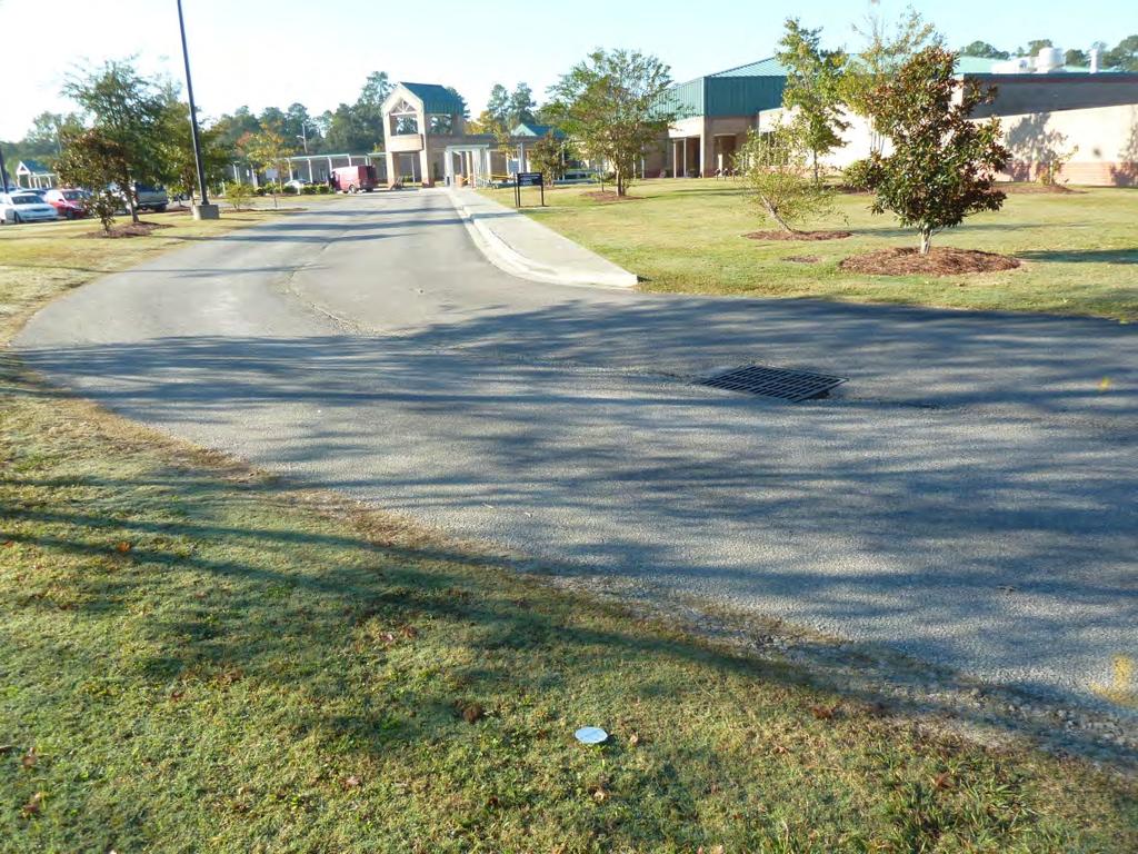
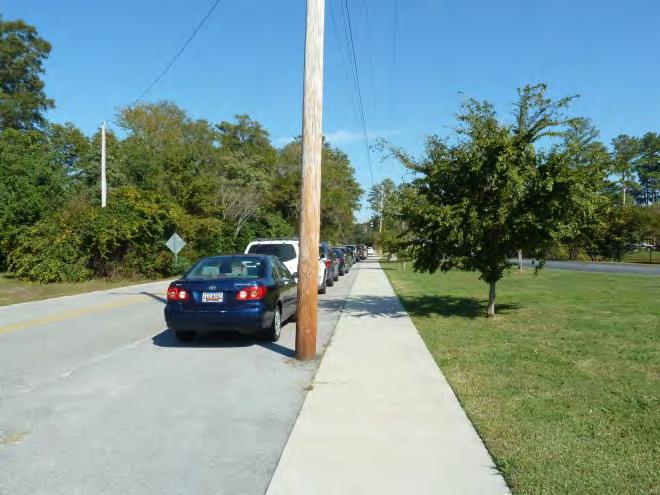
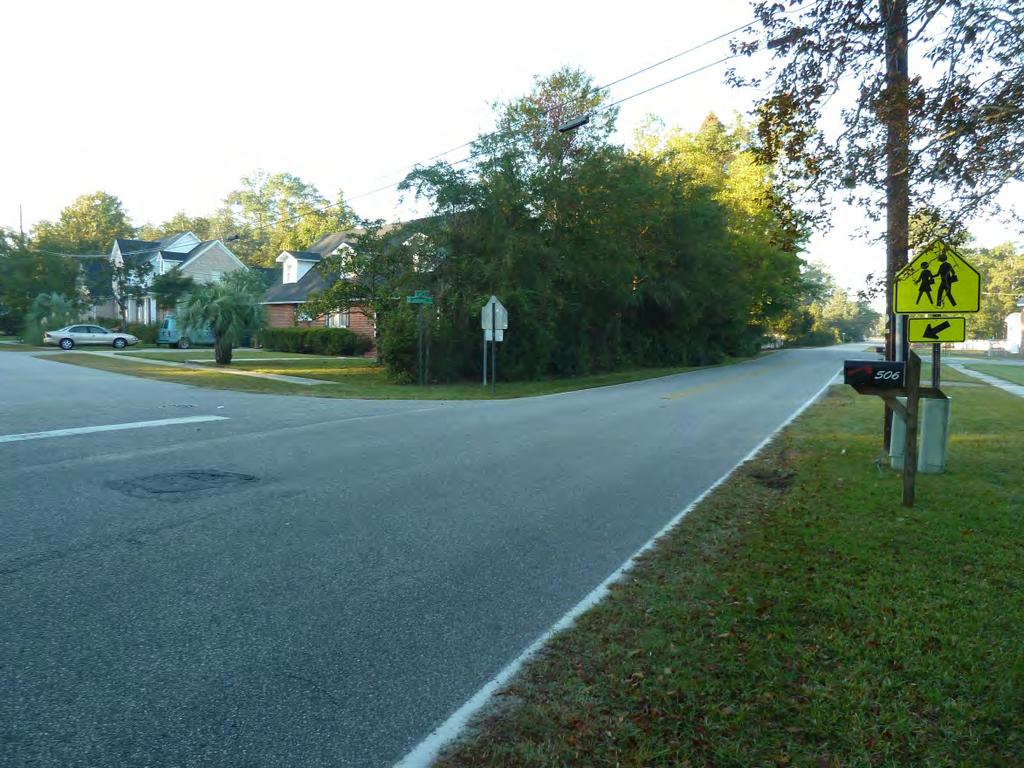
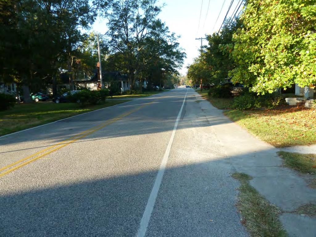
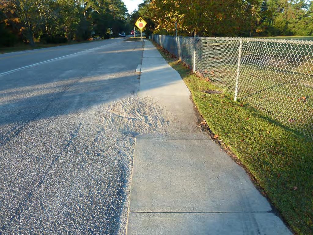
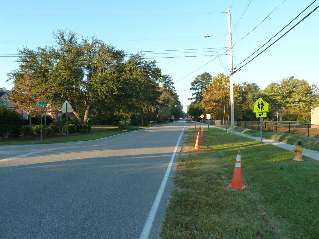
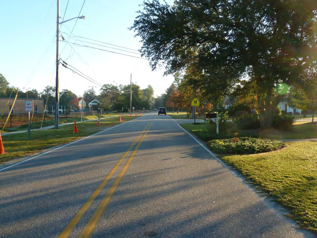
10 Issue: School campus not optimally designed for pedestrian and bicycle access Specific concerns include: Lack of a convenient, accessible pedestrian pathway between the sidewalk on Snowhill Drive and the school s main entrance. The sidewalk on the west side of the drop-off/ pick-up drive does not extend to Snowhill Drive. Consequently, students must walk in the drop-off/pick-up driveway or cut across the grass to access school. The drop-off pick-up driveway is especially uncomfortable to walk along at dismissal, since drivers queue in two lines and use the full width of the roadway. Lack of a safe and convenient way for bicyclists to access school grounds. Bicyclists ride on sidewalks and grass to avoid traffic in the bus loop and drop-off/ pick-up drive. Lack of crosswalks or signs at school driveways to alert drivers to look out for pedestrians. Wide driveway entrances/exits and wide turning radii which can encourage higher motor vehicle speeds. Issue: Lack of pedestrian and bicycle infrastructure near school campus Specific concerns include: Figure 4 Campus sidewalk network does not connect to Snowhill Drive. Consequently, students must walk in the grass or in the drop-off/ pick-up drive. Lack of sidewalks. Although some streets near school have sidewalks (e.g., Twelfth Avenue (north side) and Fifteenth Avenue (south side)), most do not. Sidewalks improve pedestrian safety by separating pedestrians from motor vehicles. Lack of separation between the sidewalks and roadways. Where sidewalks exist, they are generally not separated from the roadway by curbs. Some sidewalks segments also lack a buffer zone between sidewalk and Figure 5 The lack of curbs enables cars to ride up on the sidewalk.
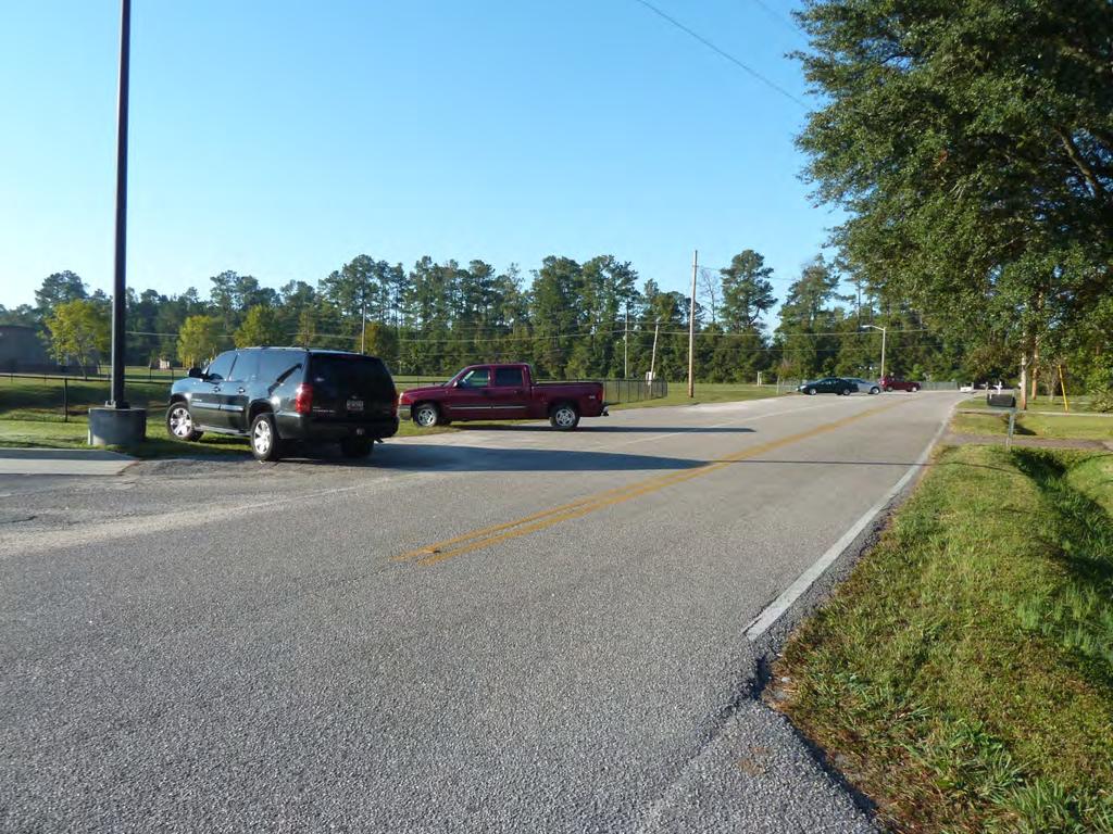
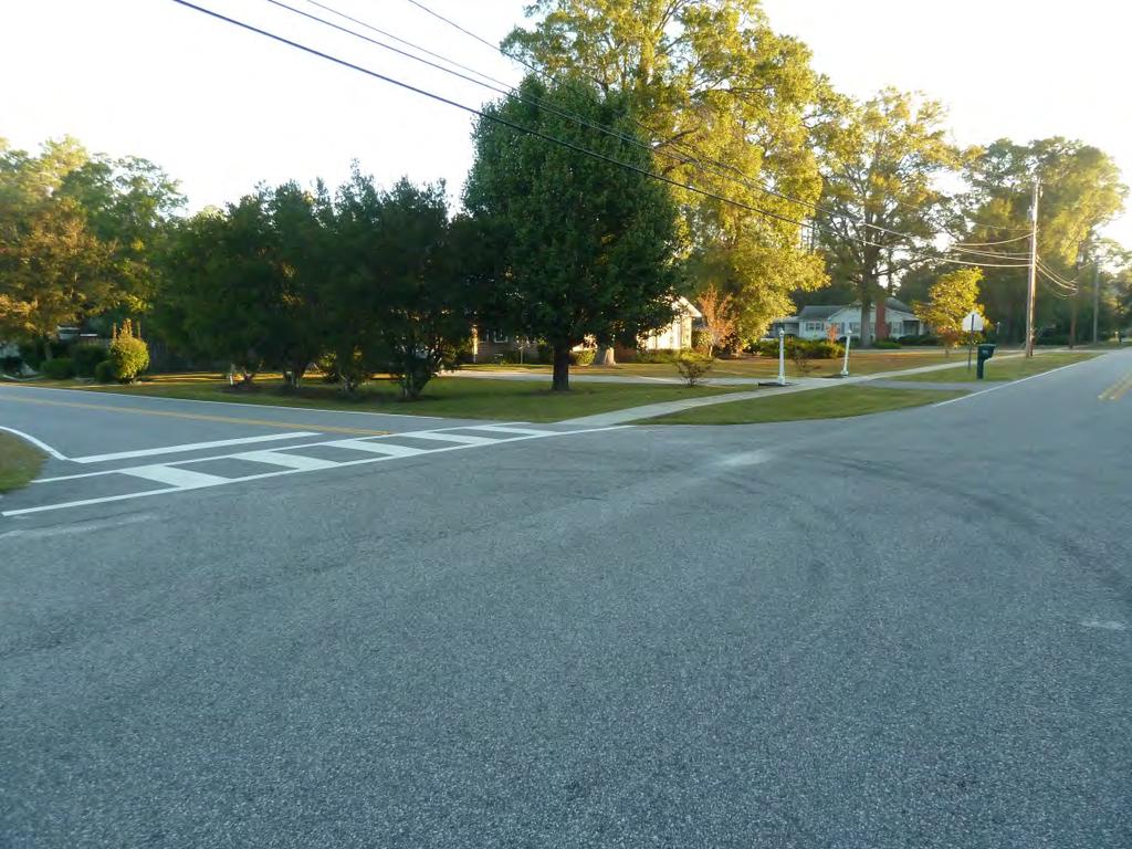
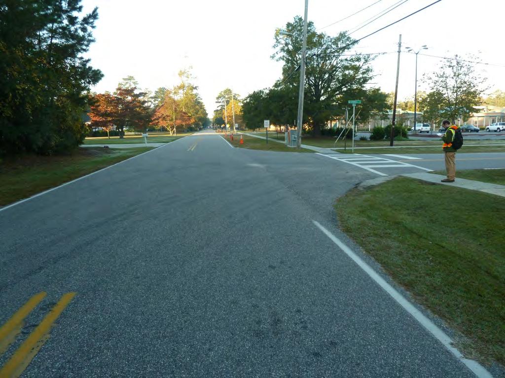
11 roadway. This enables cars to ride up on the sidewalk, a condition observed at Magrath Avenue and Snowhill Drive during dismissal. Lack of marked crosswalks. There are only two marked crosswalks within ½ mile of the school, one across the north leg of the Snowhill Drive/Twelfth Avenue intersection and one along the north leg of the Lakeside Drive/ Twelfth Avenue intersection. In some cases (e.g., intersection of Twelfth Avenue/ Winding Drive and intersection of Twelfth Avenue/ Hart Street) pedestrian crossing signs are provide without marked crosswalks. Issue: Problems with drainage along key student walking routes Drainage problems are evident in a number of locations near the school and along key walking routes (e.g., on Twelfth Avenue as it approaches Main Street). Students are less likely to use sidewalks if they are flooded. Issue: Traffic congestion on neighborhood streets surrounding the school There is significant traffic congestion near the school during arrival and dismissal times, particularly on Snowhill Drive, Magrath Avenue, and Twelfth Avenue. Traffic congestion creates uncomfortable conditions for pedestrians and bicyclists and may pose a safety risk. Issue: Concern about unsafe driver behaviors during arrival and dismissal Specific concerns include: distracted driving, speeding on Twelfth Avenue, and the failure of drivers to respect pedestrian space at the Magrath Avenue/ Snowhill Drive intersection. Issue: Parent non-compliance with school arrival and dismissal procedures Conway Elementary has refined and improved its arrival and dismissal procedures over the years and has communicated them to parents using a variety of media, including the Family Guide, letters to parents, Tiger Notes (the school newsletter), and Pride Notes ( s to parents with information and reminders). Nevertheless, some parents do not comply. The procedures were designed with the safety of all students in mind, including pedestrians and bicyclists, and the Team is concerned that these non-compliant parents may pose a safety risk.

12 TRAVEL PLAN RECOMMENDATIONS This Travel Plan is comprised of several sections detailing activities and programs for our school to implement now and projects for us to work on with local officials. Non-Engineering Plan The non-engineering plan identifies best practice education, encouragement, enforcement and evaluation activities and programs suitable for Conway Elementary. Information on the advantages and considerations for each strategy and resources to help us implement each are included in the Appendix E. 12 Month SRTS Activity Calendar Our team will pursue a smaller subset of items in the non-engineering plan during the next 12 months. We will review our work periodically, adding activities that will continue the momentum of the SRTS program. Figure 6 The Conway SRTS Team developed this plan over the course of three meetings. Engineering Recommendations With assistance from the South Carolina SRTS Resource Center, we have identified short, medium and long- engineering treatments to make walking and bicycling to school safer for our students. NON-ENGINEERING TRAVEL PLAN We identified a number of activities and programs to promote walking and biking to school. These activities and programs, while grouped by The Five Es, are dependent upon each other for their individual success. We plan to work on our highest priority programs this year, following up with other programs in successive years. We used the timeframe below to deine when to initiate programs: Type Short Medium Long Encouragement, Education, Enforcement, Evaluation Within 12 months Or, what we plan to do this year Within 2 years Or, what we plan to do next year Longer than 2 years Or, what we plan to do starting in two years
13 The activities and programs we expect to work on in the short, medium, and long are discussed below. We have included a calendar in Appendix A to indicate the sequencing of activities and programs in the short. EDUCATION STRATEGIES The education strategies we have selected are aimed at providing all students with pedestrian safety and bicycle safety skills they can apply throughout their lifetimes. They are further designed to educate parents regarding arrival and dismissal procedures and how they can support safe walking and bicycling. Integrate pedestrian safety instruction into the curriculum (short ). Pedestrian safety education will ideally occur in advance of major walk to school events so that children are adequately prepared and have an opportunity to practice the skills they have learned. The Child Pedestrian Safety Curriculum produced by the National Highway Traffic Safety Administration (NHTSA) is an example of a curriculum that might be used for this instruction. This five-lesson curriculum is designed to meet national physical and health education standards and includes cross-curricular activities to integrate safety messages into other classroom subjects. The curriculum is available for free through the South Carolina SRTS Resource Center website: Organize a bicycle rodeo (short ). Bicycle rodeos are bicycle safety clinics featuring bicycle safety skills instruction, bicycle skills practice, equipment inspections, and helmet fitting. Bicycle rodeos will be conducted by the Conway Police Department with support from Eat Smart, Move More and Horry County Schools. Raise awareness of Conway Elementary s SRTS program by incorporating information on walking and bicycling to school in communications with parents (short ). This information will seek to accomplish the following: 1) communicate Conway Elementary s support for walking and bicycling to school; 2) educate parents regarding arrival and dismissal procedures; and 3) suggest ways parents can support safe walking and bicycling, including pedestrian safety tips and tips on driving in the school zone and along student walking and bicycling routes. This information will be communicated through existing channels, including the Family Guide, letters to parents, reminders, and school newsletters, and as part of regular outreach efforts in August and January. Pride Notes will be used to encourage safe travel behaviors among students and parents. Additional channels will also be explored, including: back to school night, parent-teacher conferences, and special events involving parents. Develop and implement a community outreach campaign (medium )--The more SRTS becomes a community initiative, the more likely it is to be sustained. We will reach out to community members using a variety of media, including electronic community mailing lists, flyers, fact sheets, yard signs, presentations, tables at community festivals,
14 and informal face-to-face communications. We will also involve students in this effort by conducting a Conway Elementary SRTS logo contest. The winning logo will be used on printed materials, such as flyers, fact sheets, and yard signs. ENCOURAGEMENT STRATEGIES The encouragement strategies we have selected are aimed at helping students and their parents feel more comfortable and confident about walking and bicycling to school. Strategies include: Continue participation in International Walk to School Day (short ). International Walk to School Day is a one-day event celebrating walking and bicycling to school. Conway Elementary participated in its first International Walk to School Day in October The event was a great success. In 2012, International Walk to School Day is Wednesday, October 3. Potential partners for International Walk to School Day include the Conway Elementary s PTO and the Conway Police Department. Resources to support walk to school day events are available on the South Carolina SRTS Resource Center s website, including tip sheets, signs, and flyers: Participate in South Carolina Walk to School Day (short ). South Carolina Walk to School Day is similar to International Walk to School Day but is specifically for schools in South Carolina. The inaugural South Carolina Walk to School Day will take place in March Schedule regular walk to school events (long ). Regular walk to school events can help build on momentum established during International Walk to School Day. We will begin by conducting these events on a bimonthly or monthly basis. If they prove successful, we will schedule them weekly. Participation will be encouraged by establishing a remote drop-off location for students who cannot walk or bicycle from home, providing walking school buses and bicycle trains along key routes, providing incentives through a frequent walker club. Remote drop-off locations, walking school buses, and frequent walker clubs are described below. Establish walking school buses and bicycle trains (short ). Walking school buses are adult supervised groups of students walking to school. Bicycle trains are the same conceptually but conducted on a bicycle. In the short we will establish at least one walking school bus and one bicycle train with the intention of expanding the program in medium and long. Potential routes for the school s first walking school bus include Twelfth Avenue west of the school. Potential routes for the school s first bicycle train include the Lakeside Drive/Magrath Avenue route currently traveled by some student bicyclists. The status and visibility of walking school bus and bicycle train participants will be enhanced by providing participants with reflective vests. Resources to support walking school buses can be found on the South Carolina SRTS Resource Center s
15 website, including a tip sheet and an invitation for parents: Additional guidance on forming walking school buses and bicycle trains can be found in The Walking School Bus: Combining Safety, Fun and the Walk to School, available on the National Center for Safe Routes to School s website at: Identify potential park and walk locations (short ). Park and walk locations can improve conditions for pedestrians and bicyclists by decreasing traffic congestion around school, and they also offer students who cannot walk or bicycle from home an opportunity to exercise and develop safe walking skills. A park and walk location was identified for International Walk to School Day in We will explore other potential park and walk sites, such as churches, parks, and retail parking lots. Once park and walk have been identified, they can be utilized during International Walk to School (short-), South Carolina Walk to School Day (short-), and regular walk to school events (long-). Resources to support park and walk locations are available on the South Carolina SRTS Resource Center s website: Establish a frequent walk club (medium ). Frequent walker clubs involve tracking and rewarding students who walk and bicycle to school. They can be set up as competitions between individuals or classes. They can also include walking and bicycling beyond the trip to school. For example, the school can provide credit for distance walked at home, to and from bus stops, and on community track next to the school. Encourage and facilitate carpooling (short ). Carpooling can improve conditions for pedestrians and bicyclists by decreasing traffic volumes in and around school sites. Less traffic also means better air quality near schools. Websites such as DivideTheRide.com are geared toward busy families with schoolchildren and can help facilitate carpool organization. ENFORCEMENT STRATEGIES The enforcement strategies we have selected are aimed at changing the behavior of drivers and improving conditions for walkers and bicyclists. Strategies include: Conduct speed study on Twelfth Avenue (short ) The Conway Police Department will conduct a speed study on Twelfth Avenue near the school. If the Conway Police Department finds evidence of speeding during school arrival and dismissal times, we will request speed enforcement and an engineering assessment to deine appropriate traffic calming measures.
16 Encourage parents of Conway Elementary students to sign a safe driving pledge (short ) Parents will pledge to drive the speed limit on neighborhood streets, respect pedestrians and bicyclists, and avoid distracted driving. EVALUATION STRATEGIES The evaluation strategies we have selected are aimed at measuring the effectiveness of SRTS efforts over time and helping the program adapt to changing conditions. Strategies include: Complete Parent Surveys and Student Travel Tallies (short ). Parent Survey and Student Travel Tally forms are provided by the National Center for Safe Routes to School and will be conducted annually in October. Conduct walk audit (short ). Walk audits will be conducted in coordination with the South Carolina Department of Health and Environment, which is conducting walk audits throughout Conway. Conduct annual observation of school arrival and dismissal (short ). Use pre and post tests to understand student retention of pedestrian and bicycle safety instruction (short ). Assessments are included in the NHTSA Child Pedestrian Safety Curriculum. Evaluation Tool Leader Schedule Parent Surveys Student Tallies Walk Audit Maquitta J. Davis, Principal Maquitta J. Davis, Principal Jennifer Maddox, Chronic Disease Manager Annually in October Annually in October Annually, two weeks before school Observe Arrival and Dismissal Shannon McAlister Physical Education Teacher Annually in September Use Pre and Post Tests to Understand Student Retention Shannon McAlister Physical Education Teacher Annually when pedestrian and bicycle safety instruction is given Track Body Mass Index Cindy Vincent, RN School Nurse Annually
17 ENGINEERING TRAVEL PLAN Our goal for engineering improvements is to improve the physical conditions for walking and bicycling along routes students currently use, as well as routes with substantial potential for walking and bicycling. These engineering improvements generally fall into three categories: provide sidewalks and paths, improve intersections crossings, and improve the school site to better accommodate pedestrians and bicyclists during arrival and dismissal. Our priorities reflect what we believe to be most important with regards to safety and encouraging more walking and biking. The recommendations in Appendix B are drawn from nationally recognized treatments to improve conditions for walking and bicycling, particularly for students, and each recommendation meets basic engineering guidelines for safety and signage, such as the Manual for Traffic Control Devices and the American Association of State and Highway Officials guide. A description of these typical SRTS engineering treatments can be found in Appendix D: Glossary of SRTS Infrastructure Treatments. The engineering treatments shown are based on national best practice design techniques; however some treatments are not in wide use by SCDOT and may necessitate additional review. Furthermore, as these are preliminary recommendations, each location may require further engineering analysis, public input, design, and review by the appropriate agency(ies) prior to implementation. Engineering Recommendations for specific locations are located in Appendix B. In general, these projects increase in cost and complexity from signs and markings upwards to sidewalk or path construction. We assigned recommendations as short- or long- based on these generalizations. However, we recognize that site, soil, materials, right-of-way acquisition, and environmental regulations also impact the cost and complexity of any given project. Accordingly, actual timeframes may vary depending on the lead agency, design and construction process for each recommendation. Short Within 2 years Medium Within 5 years Long Longer than 5 years The team prioritized the infrastructure improvements as high, medium or low. The factors affecting this ranking include:
18 Locations with specific safety concerns Locations along existing student walking or bicycling routes, or with a significant number of school family residences Locations within ½ mile of school where bus service has been eliminated Locations that are priorities for the school community CONSIDERATIONS FOR DESIGN, PROJECT SELECTION, AND FUNDING All infrastructure recommendations in this plan are considered planning level and may require further engineering analysis, design, or public input before implementation. Recommended changes to existing traffic patterns (adding a signal, adding a stop sign, changing lane patterns, etc.) will require a study to evaluate the potential impact that the recommendation could have on existing traffic conditions. If funded through SCDOT, this study must meet the standards and guidelines of SCDOT. Drainage, existing utilities and Americans with Disabilities Act (ADA) compliance will need to be evaluated for all recommendations at the time of design. ADA guidelines recommend particular design features to accommodate persons with disabilities. ADA design considerations for curb ramps, sidewalks and paths, include appropriate slopes, landing areas, surface conditions, and use of detectable warning materials for visually impaired pedestrians, among other design features.. Right-of-way was not evaluated as a part of this project. Recommendations assume that sufficient right-of-way exists or that a method to gain needed right-of-way will be identified as the project progresses. SCDOT will not be responsible for electric usage or maintenance expenses associated with lighting installation. More information on the types of projects eligible for SRTS funding is available through SC DOT at APPENDICES A. Non-infrastructure Strategies Calendar B. Location-Specific Engineering Recommendations (Location Key and Recommendations Table) C. School Profile D. Glossary of SRTS Infrastructure Treatments E. Non-Engineering Strategies Resource Guide F. Conway Sidewalk Map G. Photo Gallery
19 APPENDIX A: NON-INFRASTRUCTURE STRATEGIES CALENDAR Activity Coordinator Jan Feb March 2012 April 2012 May 2012 June 2012 July 2012 Aug Sept Oct Nov Dec Complete EDUCATION Integrate pedestrian safety instruction into the curriculum (Note: includes pre- and post-tests) Lead Shannon McAlister Plan Implement Organize a bicycle rodeo Lead Chief Gosnell and Shannon McAllister Plan Implement Incorporate information on walking and bicycling to school in communications with parents Lead Plan Implement ENCOURAGEMENT Maquitta Davis Continue participation in International Walk to School Day Lead Shannon McAlister Plan Implement Participate in South Carolina Walk to School Day Lead Shannon McAlister Plan Implement Establish walking school buses and bicycle trains Lead Plan Implement Angel Rabon
20 APPENDIX A: NON-INFRASTRUCTURE STRATEGIES CALENDAR Activity Coordinator Jan Feb March 2012 April 2012 May 2012 June 2012 July 2012 Aug Sept Oct Nov Dec Complete Identify potential remote drop-off and pick-up locations Lead Shannon McAlister Plan Implement Encourage and facilitate carpooling Lead Angel Rabon and Maquitta Davis Plan Implement ENFORCEMENT Conduct speed study on 12 th Avenue Lead Reginald Gosnell Plan Implement Encourage parents of Conway Elementary students to sign a safe driving pledge Lead Angel Rabon and Maquitta Davis Plan Implement EVALUATION Complete Parent Surveys and Student Travel Tallies (Annually) Lead Maquitta Davis Plan Implement Conduct walk audit (Annually) Lead Jennifer Maddox Plan Implement
21 APPENDIX B: LOCATION-SPECIFIC ENGINEERING RECOMMENDATIONS SRTS engineering strategies create safer environments for walking and bicycling to school through improvements to surrounding infrastructure. These improvements focus on reducing motor vehicle speeds and conflicts with pedestrians and bicyclists. They establish improved crossings, walkways, trails, and bikeways. The following table provides a summary of the engineering strategies recommended for Conway Elementary School. These recommendations were developed by Toole Design Group, LLC based on input received from the Conway Elementary School SRTS Team. The table includes an estimate of time likely needed to implement the recommended improvements at each site (Estimated Time Frame). All proposed improvements have been prioritized at each site for the Conway Elementary School SRTS Team (Team Priority). These recommendations are for planning purposes only and may require further engineering analysis, design, or public input before implementation and should be in full compliance with the Manual on Uniform Traffic Control Devices for Streets and Highways (MUTCD), 2009 edition. The process for implementation of each recommendation will vary depending on the lead agency for construction (e.g. the local municipality, county, or SCDOT.) The attached Location Key indicates the location of each recommendation site in relation to the school. The following summary table describes each location and details the components of each recommendation. 1


22 OAK ST Legend!( SCHOOL DISMISSAL LOCATIONS!( INTERSECTION IMPROVEMENT COLLINS ST SIXTEENTH AVE CANAL TER!( SEGMENT IMPROVEMENT MCKEITHAN ST FIFTEENTH CT MAYFAIR TER STILLEY CIR PROPOSED SIDEWALK SNIDER ST JACKSON LN!( SNOW HILL DR M SNIDER ST WOODY LN LITTLE ST ESDALE LN BUSBEE ST SHERWOOD DR PROPOSED SIDEWALK & SHARED LANE MARKINGS Disclaimer: This map is a graphic representation only. It is NOT a survey. All efforts have been made to ensure its accuracy. However, the City of Conway disclaims all responsibility & liability for the use of this map. ³!( I ELEVENTH AVE A ST ADELINE CT PROPOSED SHARED LANE MARKINGS AND PATH SWEETBRIAR LN CANTERBURY LN FIFTEENTH AVE FOURTEENTH AVE!(!( G F LAKESIDE DR B ST!( H LAKESIDE DR HART ST!(!(!( E F B D C B CONWAY ELEMENTARY SCHOOL HART ST ELEVENTH AVE TWELFTH AVE!(!( J!(!(!( A WINDING RD!(!(!( A!( K N MAGRATH AVE!( L SNOWHILL DR!( M TISDALE ST PROPOSED IMPROVEMENTS AT SCHOOL DRIVE WOODLAND ST!( I LAKELAND DR!( JESSAMINE ST PARK AVE PROPOSED SIDEWALK & SIDEWALK WIDENING ALONG TWELFTH AVE CONWAY ELEMENTARY SCHOOL IMPROVEMENTS DECEMBER, JERRY BARNHILL BLVD CONWAY, SC (843) ph (843) fax February 2, :24:17 AM\\Coc-srv2\4310\ZONING ORDINANCE REWRITE\GIS Files\PSI-Parcels\PSI PARCELS WITH AERIALS AND TABLES\PSI PARCELS AT OLD CITY SHOP SITE AERIAL.mxd
23 Site Need Recommendation Time Frame Ranking Factors Team Priority A School Grounds (Access from Snowhill Drive) There is no pedestrian access between the school entrance and sidewalk on the south side of Snowhill Drive. Students must cross grass and/or walk down the drop-off/pick-up drive. 1- Construct concrete path between sidewalk on south side of Snowhill Drive at Snowhill Drive/ Park Avenue intersection and school front entrance. 2- Mark high-visibility crosswalks where path crosses parking lot entrance and pick-up/drop-off drive. 3- Construct curb extensions on both sides of the parking lot entrance to shorten pedestrian crossing distance and tighten the vehicle turning radius. Short Short Short Safety concerns Existing walking or bicycling routes Within ½ mile of school where bus service has been eliminated Priorities for the school community High B Magrath Avenue from Lakeland Drive to Lakeside Drive There are no sidewalks except short segments on the south side west of Snowhill Drive and east of Lakeside Drive. There are also no existing curbs. Bike route signs are small and easy to miss. The Community track is west of the school. Track users might also benefit from pedestrian access improvements. 1- Complete the sidewalk on the south side of street. Parking should be converted at the community track from perpendicular to parallel. 2- Add shared lane markings to increase awareness of the bicycle route. Long Short Safety concerns Existing walking or bicycling routes Within ½ mile of school where bus service has been eliminated Priorities for the school community Low 2
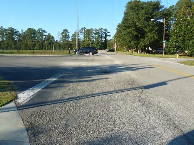
24 Site Need Recommendation Time Frame C Magrath Avenue at Snowhill Drive Stop controlled for traffic on Snowhill Drive The intersection is congested at arrival and dismissal times, creating uncomfortable conditions for pedestrians and bicyclists. A lack of marked crosswalks reduces motorist awareness of pedestrians and decreases pedestrian comfort. There are no curbs. At dismissal, cars park on or drive over the sidewalk on the southwest corner, obstructing pedestrian access. 1- Install high-visibility crosswalks across the south and west legs of the intersection. 2- Construct curbs on the southwest corner of the intersection Short Short Ranking Factors Safety concern Existing walking or bicycling routes Within ½ mile of school where bus service has been eliminated Priorities for the school community Team Priority Medium 3
25 Site Need Recommendation Time Frame Ranking Factors Team Priority D Magrath Avenue at Snider Street Stop controlled for traffic on Snider Street The lack of marked crosswalks reduces motorist awareness of pedestrians and decreases pedestrian comfort. The bus driveway forms the south side of the intersection. The width is approximately 55 feet and turning radii appear wider than necessary to accommodate buses. The crossing at the driveway entrance is wide and increases pedestrian exposure. 1- Install a high-visibility crosswalk across Magrath on the west side. Add school crossing signage. 2- Install a high-visibility crosswalk across the driveway. Add a stop sign and stop bar for exiting buses. 3- Construct curbs at the driveway entrance/exit and tighten turning radii. Short Short Medium Safety concerns Existing walking or bicycling routes Within ½ mile of school where bus service has been eliminated Priorities for the school community Medium 4- Construct channelization islands to force slower bus speeds at the driveway entrance/ exit. Medium 4
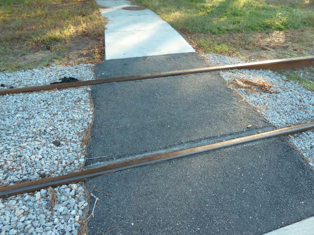
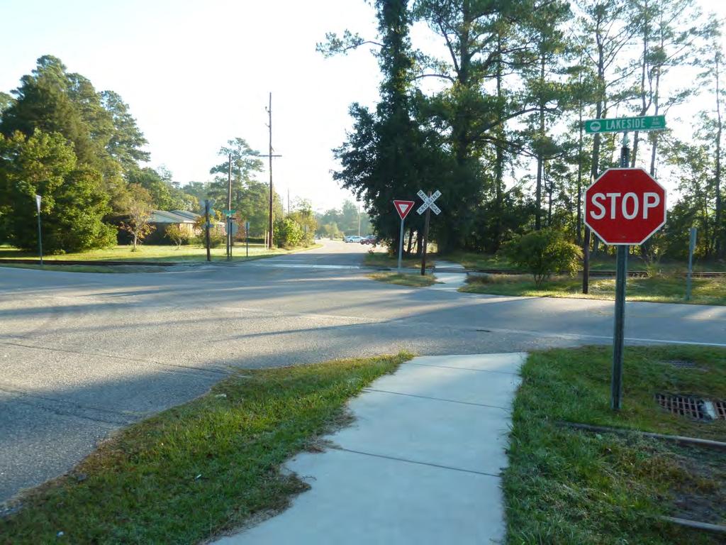
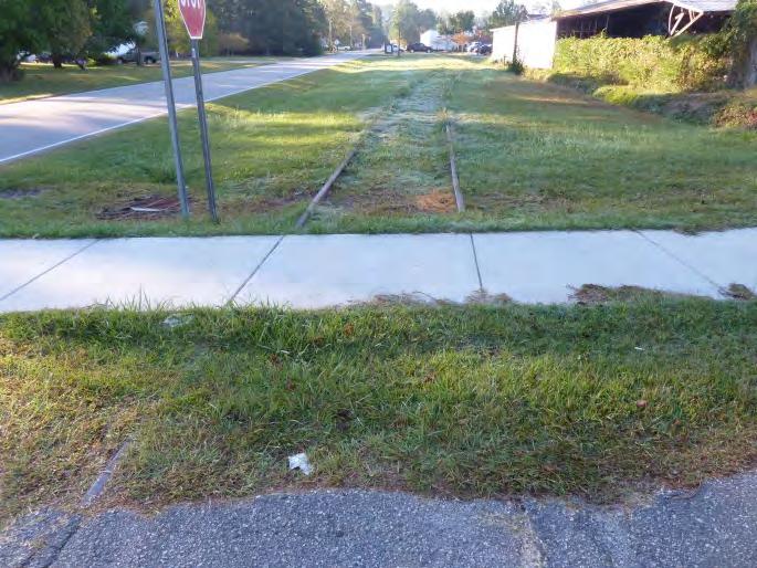
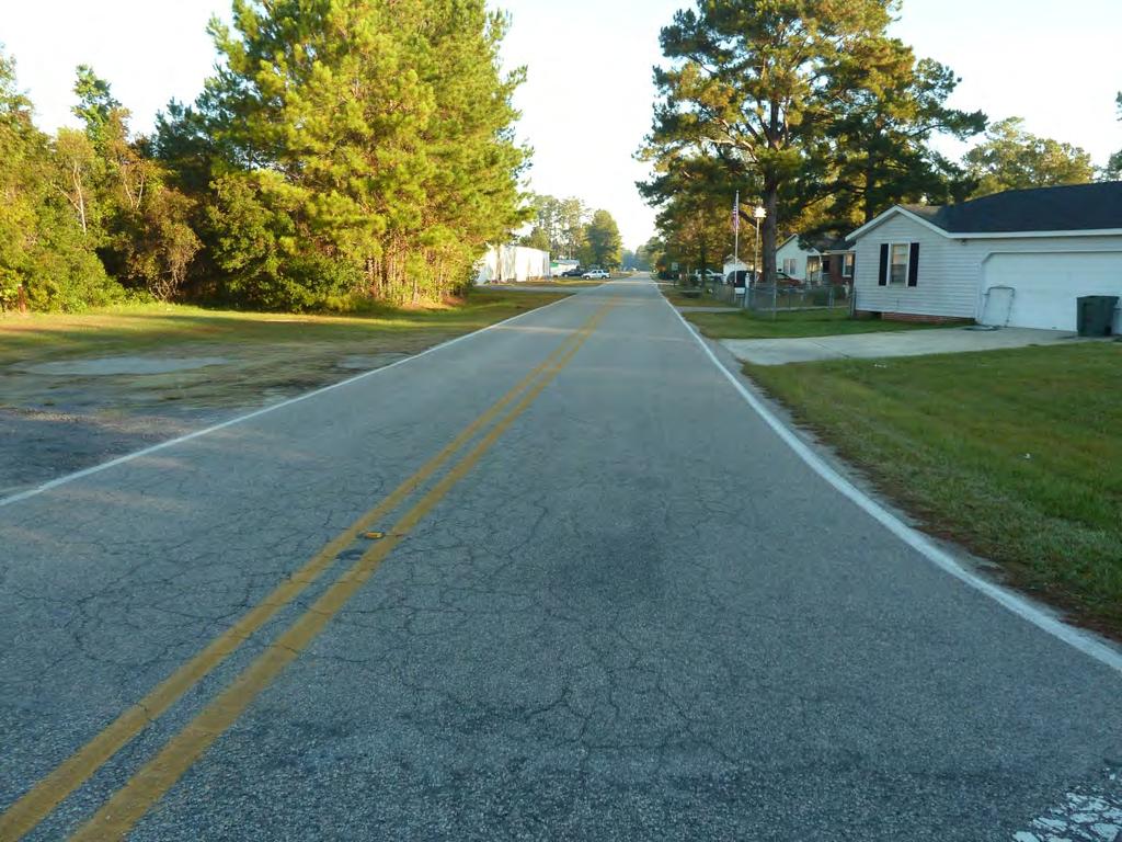
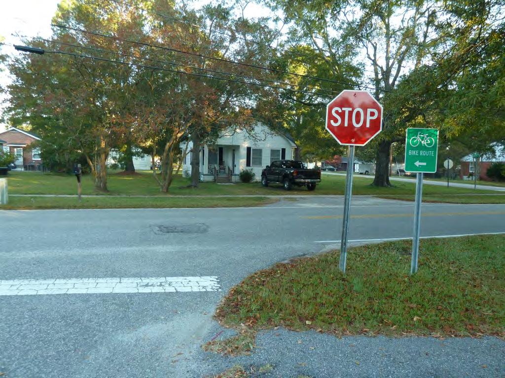
26 Site Need Recommendation Time Frame Ranking Factors Team Priority E Magrath Avenue at Lakeside Drive Stop controlled for traffic on Magrath Avenue The asphalt path across the railroad tracks contains deep ruts and is not ADA-compliant. There is no crosswalk across Lakeside Drive on the south side of the intersection. This would connect the sidewalk segment on the south side of Magrath Avenue to the sidewalk on the south side of 15th Street. This reduces motorist awareness of pedestrians. 1- Fix accessibility issues at the track crossing. 2- Convert the intersection to a four-way stop. 3- Install a high-visibility crosswalk and stop bar across the south leg. Medium Medium Medium Safety concerns Existing walking or bicycling routes Within ½ mile of school where bus service has been eliminated Priorities for the school community Medium F Lakeside Drive from 15 th Street to 12 th Avenue On Conway s Bike Trail Map, the route is marked with small bike route signs that are easy to miss. The abandoned railroad creates an opportunity for a shared use path. There are no curbs. 1- Add shared lane markings to increase awareness of the bicycle route. 2- Construct a shared use path in the abandoned rail right-ofway. Short Long Safety concerns Existing walking or bicycling routes Within ½ mile of school where bus service has been eliminated Low Priorities for the school community 5
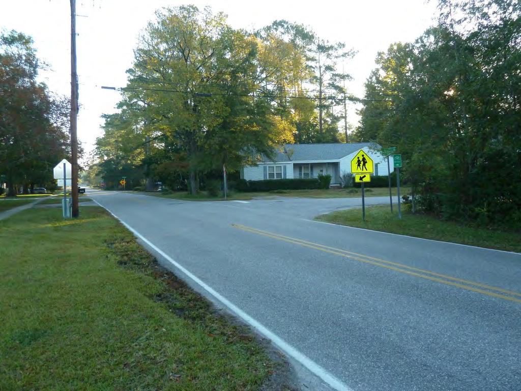
27 Site Need Recommendation Time Frame G Lakeside Drive at 12 th Avenue (west) Stop controlled for traffic on Lakeside Drive The existing crosswalk across Lakeside Drive is faded. This intersection is skewed, creating a long crossing distance. The railroad right-of-way for a future shared use path continues on the south side of the intersection; however, there is currently no marked crossing across 12th Avenue at this location. 1- Re-stripe the crosswalk across Lakeside Drive. 2- Reconstruct the intersection to make Lakeside Drive and 12 th Avenue perpendicular. 3- When the shared-use path is built, install a high-visibility crosswalk across 12 th Avenue and install warning signage as well. Short Long Long Ranking Factors Safety concerns Existing walking or bicycling routes Within ½ mile of school where bus service has been eliminated Priorities for the school community Team Priority Medium H Lakeside Drive at 12 th Avenue (east) Stop controlled for traffic on Lakeside Drive Motor vehicle speeds and volumes on 12 th Avenue were observed to be relatively high. There are existing sidewalks on the west side of Lakeside Drive south of 12th Avenue and on the north side of 12th Avenue. There are also school crossing signs provided for the 12 th Avenue crossing but there is no marked crosswalk. This reduces motorist awareness of pedestrians. 1- Install a high-visibility crosswalk across 12th Avenue. 2- Supplement school crossing signs with advanced warning signs. Short Short Safety concerns Existing walking or bicycling routes Within ½ mile of school where bus service has been eliminated Priorities for the school community High 6
28 Site Need Recommendation Time Frame Ranking Factors Team Priority I 12 th Avenue from Main Street to Lakeland Drive Motor vehicle speeds and volumes on 12 th Avenue were observed to be relatively high. This is a key student walking route, also used as part of the walking route for International Walk to School Day. The sidewalk on the north side of 12 th Street narrows west of Lakeside Drive. There is no sidewalk on the south side of 12 th Street. 1- Widen the sidewalk on the north side of 12 th Avenue west of Lakeside Drive. 2- Install a sidewalk on the south side of 12 th Avenue. Long Long Safety concerns Existing walking or bicycling routes Within ½ mile of school where bus service has been eliminated Priorities for the school community High J 12 th Avenue at Winding Street Stop controlled for traffic on Winding Street School crossing signs are provided to cross 12 th Avenue, but there is no marked crosswalk. This reduces motorist awareness of pedestrians. 1- Install a high-visibility crosswalk across 12 th Avenue. Short Safety concerns Existing walking or bicycling routes Within ½ mile of school where bus service has been eliminated High Priorities for the school community 7
29 Site Need Recommendation Time Frame K 12 th Avenue at Snowhill Drive (west) Stop controlled for traffic on Snowhill Drive Motor vehicle speeds and volumes on 12 th Avenue were observed to be relatively high at this site. The intersection is congested at arrival and dismissal times, creating uncomfortable conditions for pedestrians and bicyclists. There is a marked crosswalk across Snowhill Drive but not across 12 th Avenue. The visibility of students in the crosswalk is very low for eastbound traffic turning left. 1- Install Turning traffic watch for pedestrians warning signage on 12 th Avenue. 2- Install a high-visibility crosswalk across 12 th Avenue from the southwest corner. Add school crossing signage. Short Short Ranking Factors Safety concerns Existing walking or bicycling routes Within ½ mile of school where bus service has been eliminated Priorities for the school community Team Priority High L 12 th Avenue at Snowhill (east) Stop controlled for traffic on Snowhill Drive Motor vehicle speeds and volumes on 12 th Avenue were observed to be relatively high. A lack of marked crosswalks reduces motorist awareness of pedestrians and decreases pedestrian comfort. 1- Install a high-visibility crosswalk across 12 th Avenue from the northwest corner. Add school crossing signage. 2- Install a crosswalk across Snowhill Drive (east branch). Short Short Safety concerns Existing walking or bicycling routes Within ½ mile of school where bus service has been eliminated High Priorities for the school community 8
30 Site Need Recommendation Time Frame M Snowhill Drive from Lakeland Drive to Sherwood Drive The street branches out south of the Park Avenue intersection. The east branch inates at Lakeland Drive, and the west branch inates at 12 th Avenue. There are no sidewalks on Snowhill Drive except on the west side adjacent to school property. There are also no curbs on Snowhill Drive. Relatively high traffic volumes were observed during arrival and dismissal times. 1- Complete the sidewalk on the west side of the street north of Magrath Avenue. 2- Construct a sidewalk on the east side of the street from the Park Avenue intersection to Lakeland Drive (east branch). The sidewalk should connect to the marked crosswalk proposed for the Park Avenue/ Snowhill Drive intersection (see site N below). Long Long Ranking Factors Safety concerns Existing walking or bicycling routes Within ½ mile of school where bus service has been eliminated Priorities for the school community Team Priority Low N Snowhill Drive at Park Avenue Stop controlled for traffic on Park Avenue and traffic on Snowhill Drive (east branch only) The lack of marked crosswalks reduces motorist awareness of pedestrians and decreases pedestrian comfort. Turning radii appear wider than necessary, increasing pedestrian exposure to motorists. 1- Install a high-visibility crosswalk across 12 th Avenue. The crosswalk should connect to the proposed sidewalk on the east side of Snowhill Drive and align with the accessible pedestrian pathway proposed for Site A (School Grounds). School crossing signage should also be added. Long Safety concerns Existing walking or bicycling routes Within ½ mile of school where bus service has been eliminated Low 2- Reduce curb radii on the east side of the intersection. Long Priorities for the school community 9
31 APPENDIX C: SCHOOL PROFILE (AS SUBMITTED )
32 Conway Elementary School Profile School Name: Conway Elementary SCHOOL BACKGROUND School Address: 1101 Snowhill Drive Conway, SC School County: Horry County Grades Taught: K-5th Demographics: 1. Total Enrollment: Number of students that receive free and reduced lunch: Number of students living within 0.25 mile: (haven t received student addresses) 4. Number of students living within 0.5 mile: 5. Number of students living within 1 mile: 6. Number of students living within 1.5 mile: Year school was built (or opened): 2003 School Attendance Boundaries (Street Names, or provide a map with boundaries indicated) **I have hard copy maps of the schools, but could not get the GIS data from anyone in Horry County. North: South: East: West: After-school activities: Activity name Number of students Time released YMCA- sports and physical activity :30-6:00 pm Page
33 Arrival and Dismissal Procedures MORNING ARRIVAL Travel Mode Procedure Time Bus riders Bus riders are dropped off in the back bus loop and students go straight to class 7:00-7:30 am Walkers/Bikers Private Vehicles Sidewalk and bike rack on side of the school One line of traffic comes through front loop of school. Teachers greet cars. 7:00-7:30 am 7:00-7:30 am AFTERNOON DISMISSAL Travel Mode Procedure Time Bus riders Buses pick up at back of the school. Dismissed first. 2:20-2:45 pm (Kind and 2 nd grade first; older grades second) Walkers/Bikers Students report to the cafeteria. After buses have left they exit the back or front entrance to the school. 2:20-2:45 pm Private Vehicles Students meet in gym and wait for their name and station # to be called to exit. 2:20-2:45 pm STUDENT TRAVEL MODES Mode Count Bus Riders Walkers and Bicyclists 60 Private Vehicle 200 **Approximations Known School Walking Routes (attach a map if available): Students walk from 12 th Avenue, down Snowhill Drive, Lakeland Dr, and Magrath Avenue. Page
34 Safety Education/Encouragement Activities, Events or Curriculum: 1. Jump Rope for Heart (during PE) and Field Day 2. Standard 17- Review safety procedures every semester. Students and teachers participate. The principal, asst principal, and bus leader work in groups. 3. PBIS stations- review the Positive Behavior Intervention and Support procedures twice a year. Can incorporate safety into this. Are there any known barriers or issues for students walking to school? Distance. Most students live outside the 2 mile radius of the school. Number CROSSING GUARDS Location 0 Is there an active safety patrol program at the school? Yes No If yes, what grades can participate? Did the school complete pre-evaluation data? (Circle either No or Yes) Parent Surveys: No Yes Date Completed Submitted to National Center: Y / N Student Travel Tallies: No Yes Date Completed 09/2011 Submitted to National Center: Y / N Page
35 Safe Routes to School Team Members Identified Name Title Organization Maquitta Davis Principal Conway Elementary Shannon McAlister PE Teacher/Champion Conway Elementary Jennifer Maddox Chronic Disease Manager DHEC Region 6 Public Health Michael Leinwand Planning Director City of Conway Planning Dept Jim Wright Director of Transportation Horry Co School District Who owns/maintains the roads in town? Local, County, State, Combination. Describe distribution below: _12th Avenue- SCDOT Lakeside Drive- SCDOT Snowhill Drive- SCDOT Magrath Ave- SCDOT Snider St- City of Conway Jackson Lane- City Tenth Ave- City Eleventh Ave- City Fourteenth Ave- City Fifteenth Ave- City Page
36 APPENDIX D: GLOSSARY OF SRTS INFRASTRUCTURE TREATMENTS Accessible Pedestrian Signals: Accessible Pedestrian Signals (APSs) include pedestrian signal features, including push buttons that are designed to accommodate persons with disabilities, particularly visually impaired. Accessible Pedestrian Signals can be appropriate where specifically requested to assist disabled citizens, or where conditions warrant (i.e. areas where it is difficult to cross using non-visual cues, complex signal phasing, complex intersection geometry, etc.). The 2009 MUTCD includes the following guidance: if a leading pedestrian interval is used, the use of accessible pedestrian signals should be considered (2009 MUTCD Section 4E.06). Leading Pedestrian Intervals: At signalized intersections, Leading Pedestrian Intervals (LPIs) allow the crosswalk/pedestrian movement to begin crossing 3-6 seconds before the green light is given to motor vehicle traffic in the same direction. LPIs are appropriate at signalized intersections where there is relatively heavy pedestrian volume or significant conflicts with turning vehicles. Pedestrian Countdown signals: Countdown signals provide a numerical display of time remaining once the red hand or Don t Walk symbol appears, allowing pedestrians to see how much time they have left to complete crossing the street. Traffic Controls at Intersections: Traffic signals regulate the flow of all travelers across intersections, regardless of mode. Signals for both motorists and pedestrians are particularly important at high-use, mid-block crossings on higher speed roads, multi-lane roads, or at highly congested intersections (2009 MUTCD). Rapid Flashing Beacons: Rapid flashing beacons will increase the visibility of students and all pedestrians as they cross the roadway. This type of signal is pedestrian-activated, i.e., the signal will only flash if a pedestrian has pushed a button, indicating that they need to cross the street. Pedestrian Hybrid Signals Pedestrian hybrid beacons are a special type of hybrid beacon used to warn and control traffic at an unsignalized location to assist pedestrians in crossing a street or highway at a marked crosswalk. Pedestrian hybrid beacons have the advantage of providing a controlled crossing for pedestrians without delaying motorists unnecessarily. They remain dark until activated by a pedestrian. Activation results in a sequence of amber and red beacon lights, which signal to drivers when to stop for crossing pedestrians and when to go again after pedestrians have cleared the crosswalk. Curb Extensions: Curb extensions are recommended to reduce pedestrian crossing distances (and thus exposure to traffic) and to slow motor vehicle turning speeds. Curb extensions located along school bus routes should effectively calm traffic, but not impede buses from making the turn.
37 Curb Radius Reductions: Curb radius reductions are recommended to slow motor vehicle turning speeds and to reduce pedestrian crossing distances (and thus exposure to traffic). Curb radius reductions involve tightening the motor vehicle turning radius at an intersection without extending the curb line into a parking lane. Curb radius reductions located along school bus routes should effectively calm traffic but not impede buses from making the turn. High Visibility Crosswalks: High visibility crosswalk striping improves the visibility of pedestrians to motorists. Different striping patterns can be used, most commonly variations of the ladder style. Thermal plastic materials should be used to resist decay. Speed Tables/Raised crosswalks: Raised crosswalks are flat-topped speed humps with crosswalk markings painted on the top. Raised crosswalks serve two purposes: they make pedestrians more visible to motorists; and they cause motorists to slow at the most critical location, where pedestrians cross (The Effects of Traffic Calming Measure on Pedestrian and Motorists Behavior, FHWA 2001). Crossing Islands Crossing islands are raised islands placed in the center of the street at intersections or midblock. They allow pedestrians to deal with only one direction of traffic at a time by enabling them to stop partway across the street and wait for an adequate gap in traffic before crossing the second half of the street. They are especially effective at reducing crashes at uncontrolled locations on busy multi-lane roadways where gaps are difficult to find, particularly for slower pedestrians, e.g. disabled, older pedestrians, and children. Stand-back Lines: Stand back lines are pavement markings placed on sidewalks a few feet from the edge of the curb. This crossing treatment used to help students know where on the corner it is safe to wait. Sidewalks and buffers: One of our long- goals is to establish a well-connected sidewalk network throughout the neighborhoods so that families can walk for more of their daily trips, rather than drive. Sidewalks are most effective when they include a buffer. This buffer increases pedestrian comfort and safety and can also serve as a place for pedestrian overflow, especially closer to the school where groups of walkers are largest. The preferred design for sidewalks in this plan is a minimum 6 wide sidewalk with a minimum 2 wide buffer. Available right of way will impact the ultimate design. The DOT standard minimum sidewalk width is 6 from back of curb. Minimum dimensions for sidewalks with buffers are a 5 sidewalk with a 2 buffer City of Conway standards are for a 5 sidewalk and a 3 wide buffer. Traffic Circles Traffic circles are placed in an intersection in lieu of stop control and to resolve issues arising with non-symmetrical intersections. Depending on the size, traffic circles are also called mini circles and roundabouts. A well-designed traffic circle serves many purposes: provides a designated place for pedestrians and bicyclists to travel through the intersection, calms traffic,
38 improves roadway capacity, encourages compliance with traffic laws, and eliminates behaviors that lead to crashes. Traffic circles can also serve as a gateway to a school campus, residential or commercial neighborhood, or a town center. Lighting: Pedestrian-level lighting will improve safety and comfort throughout the neighborhoods. We recommend that lighting be installed at the same time as sidewalks. The highest priority for lighting should be given to those intersections identified where students cross. School Zone Identification: School pavement markings are recommended to alert motorists that they are entering a school zone where pedestrians may be present both along and crossing the roadway. New pavement markings can work with existing school zone signs to reinforce the message to motorists about the school zone. Speed Feedback Signs: Communities may use a mobile speed trailer that can be placed in locations where motorists exceed the speed limit often enough that passive enforcement is appropriate. Permanently installed feedback signs provide on-going information to motorists about the speed at which they are traveling.
39 Appendix E: Non-engineering Strategies Resource Guide Strategy E s Advantages Considerations Resources Walking and Biking Safety Assembly These single-day events can be held in the fall to promote Walk to School Day. Guest speakers teach the students pedestrian and bicycle safety skills that they can use when walking and biking to school. Education, Encouragement Assures all children learn bicycle and pedestrian safety skills Establishes habits that benefit children throughout their lives, regardless of whether they currently walk or bike to school Establishes consistent messages for young pedestrians and bicyclists Provides a refresher for parents if take home materials are provided in conjunction with the assembly. It s never too late to correct bad habits. Events can make learning fun, and help strengthen community ties with event organizers and participants. Best taught using a combination of methods, including one-time instruction (e.g. assemblies), multi-lesson classroom curricula, and skills practice (e.g. bike rodeos). Requires able and willing instructors Should be age-appropriate Bicycle safety education may require an outside instructor, e.g. a police officer. Pedestrian Safety Lesson Plan and Activities WTSDMaterials.pdf National Highway Traffic Safety Administration Pedestrian Safety Lessons etycurriculum WalktoSchool.org - Classroom activities that encourage walking and biking. assroom.cfm Willie Whistle - The National Highway Traffic Safety Association has created a video to help teach children pedestrian safety skills. willie/willie.zip
40 Strategy E s Advantages Considerations Resources Continue to Participate in Walk to School Day Walk to School Day is a one-day event that celebrates walking and biking to school that {School Name} already participates in. Generally this event is scheduled for the first full week in October. Why not use this strategy multiple times a year? Education, Encouragement Excellent kick-off event for Safe Routes to School program Generates enthusiasm for walking and biking Way to raise community awareness about safety issues Can be as simple as a few kids and parents meeting to walk to school or very elaborate celebrations Can be folded into studies of international cultures as it is an international event Date is flexible- to be counted by the National Center for Safe Routes to school the event need only take place before Dec 1. Preparations for elaborate celebrations must begin several months in advance to allow time to identify partners, plan activities, and promote the event Should provide bicycle and pedestrian safety information to children and parents International Walk to School Day takes place in October but some schools organize multiple Walk to School Day (or Walk and Roll Day ) events over the course of the school year (e.g. one in the fall and one in the spring). U.S. Walk to School Day website (provides resources and event registration): International Walk to School Day website: Spice up Walk to School Day ragement/sc-srts-tip- Sheet_SpiceUpWTS.pdf Plan and promote your Walk to School Day event ragement/sc-srts-tip- Sheet_PlanPromote.pdf Include students when it is too far or unsafe ragement/sc-srts-tip- Sheet_IncludeStudents.pdf Frequent Walker/Bicyclist Program or Walking Wednesdays Track and reward students who walk and bicycle to school. Can be an individual competition or a competition among classes. Encouragement Provides positive reinforcement for walking and bicycling. Children respond to incentives. Can include all students. Can include walking and bicycling beyond the trip to school. Necessary to identify a coordinator. Establish a simple record-keeping system. Establish age-appropriate goals. Consider giving rewards to parents as well, since parents are often involved in the commute to school. Walking School Bus tip sheet ragement/sc-srts-tip- Sheet_WalkingSchoolBus.pdf Invitation to parents to join the Walking School Bus ragement/sc-srts-letter- WalkingSchoolBus.docx Frequent Walker Punch card template ragement/sc-srts-punchcard.pdf
41 Strategy E s Advantages Considerations Resources Traffic Enforcement (Staff/Crossing Guards) This can be an ongoing program for school staff and crossing guards. This works well if the school has an existing reward point program. Student Safety Patrol Program This can be an ongoing program for 5th grade students. Student safety patrols can offer educational literature to offenders to let them know about traffic safety issues (and proper behavior) surrounding the school zone. Education, Enforcement, Encouragement Education, Enforcement, Encouragement Crossing guards play an important role in helping children cross the street at key locations, reminding drivers of the presence of pedestrians, and making parents feel more comfortable about letting their children walk and bicycle to school. Staff and crossing guards can also reward students who are caught being good by issuing School Reward Points. Students can also issue citations if condoned by the school. Excellent way to educate parents and encourage appropriate behaviors while supporting the school s SRTS program. Teaches students valuable leadership skills. Requires some training and coordination with crossing guards Requires an adult organizer such as a parent, teacher, or law enforcement officer Materials such as sashes and badges are encouraged Requires adult supervision while students are on-duty Student safety patrols will also be trained to set the model example for younger students. In the last month of school, student patrols can train 3rd graders who are interested in being trained in the fall. One option is to host an end of the year party to honor the graduating safety patrols Adult School Crossing Guard Guidelines (NCSRTS) uard/pdf/crossing_guard_guidelines_web. pdf Florida School Crossing Guard Training Guidelines Lessons from Florida s Crossing Guard Program Giveaways for students when they cash-in their Reward points AAA Safety Patrol Program: Foundation/ SchoolPrograms/SchoolSafetyPatrol
42 Strategy E s Advantages Considerations Resources Bike Rodeo This is a single-day event that promotes bicycle safety. At the rodeo, students can borrow bicycles or bring their own. Education, Encouragement Events like bike rodeos make learning fun and can help strengthen community ties with event organizers and participants. At the rodeo students learn safety skills such as how to properly wear a helmet and how to behave while bike riding. The rodeo can also have a closed test course for the students to ride along. This helps the students to practice in a safe environment and gain confidence in their decision-making skills. One possible partner for this is the local police department. Requires able and willing instructors Should be age-appropriate Bicycle safety education may require an outside instructor, e.g. a police officer. These events require planning and materials to share with students Bicycling Life page on bicycle rodeos: kills/bicyclerodeo.htm An organizer s guide to bicycle rodeos Bike_Rodeo_404.2.pdf Easy steps to properly fit a bicycle helmet ry/pedbimot/bike/easystepsweb/ Walk Audit/Parent Surveys / Student tallies The team will meet annually (ideally in August before school starts) to review the accomplishments and progress from the previous school year and set new goals for the upcoming school year. Evaluation Establishes baseline information on student travel behavior and perceived barriers to walking and biking Helps deine existing needs Helps deine success of SRTS efforts and identify needed adjustments Best to conduct initial surveys before SRTS measures have been implemented Requires teacher buy-in and administrative organization Getting parents to fill out and return surveys can be a challenge. Follow up is necessary. Consider a contest among classes for highest rate of return. Student In-Class Travel Tally Form: ces/evaluation_student-in-classtravel-talley.cfm Parent Survey Form: ces/evaluation_parent-survey.cfm Instructions for Survey Administration: ces/evaluation_instructions.cfm Instructions for Data Entry: ces/evaluation_cover-sheets.cfm
43 Strategy E s Advantages Considerations Resources Walking School Buses/ Bicycle Trains Walking school buses and bicycle trains are adult supervised groups of students walking and/or bicycling to school. Education, Encouragement Adult supervision on the walk to school Can be loosely structured or highly organized Can include a meeting point in a parking lot so children and parents who must drive can participate. Adults can rotate who will lead each time. Need to identify routes where conditions support walking and there is sufficient demand for supervised walking Requires parents willing to walk with children and learn about how Walking school buses are organized and conducted. More organized structure requires considerable planning Walking School Bus tip sheet wnloads/encouragement/ SC-SRTS-Tip- Sheet_WalkingSchoolBus. pdf Bicycle Train guide wnloads/encouragement/ SC_SRTS_Bike_Train%20G uide.pdf Driving Around Schools: Keeping Children Safe urces/driving_tips.cfm Parents, Avoid Becoming a Traffic Hazard c.com/fetchfile.ashx?id=e 55bfa26-a70d-4e17-afde- 073b86cc9975 Drive Safe Campaigns Some parents are not aware of how their driving behavior can put walking students at risk. This teaches parents how their unsafe driving habits can put their children in danger. Education Has the ability to positively effect change in and community around the school Improves the safety of the walking environment Good drivers can help to set the example for good behavior. This is especially true for helping to control speeds. This requires a person to organize and administer the campaign. May not be effective at schools where parent/teacher organizations are weak Law enforcement officers would be great at speaking at the campaign events. Sometimes, due to their heavy schedules that can be difficult to pin down. A good way to contact parents is at back to school night and PTA meetings. Starting at the beginning of the year helps to prevent bad habits from starting. Law enforcement officers (or other teachers) can hold a brief assembly to explain the dangers of unsafe driving in school areas. Law enforcement officers can provide a demonstration of how difficult it is to quickly stop a moving vehicle at 50, 40 and 30 mph. The National Center has information on how the speed of the vehicle can affect the severity of injury that the pedestrian experiences in a crash.
44 Strategy E s Advantages Considerations Resources Crossing Guard Appreciation Day Crossing guards help our children cross the road safely in the mornings and afternoons, in all weather conditions. Remind them that you appreciate their service and dedication. Students can create thank you cards that they deliver themselves during their walks home, or teachers and administrators can honor them formally during a school assembly. Encouragement Maintains a positive relationship between the crossing guards and the school/community. Can inspire crossing guards to continue to be reliable, safety figures. Creates an opportunity to remind students why it is important to practice safe walking skills. Requires coordination between the crossing guards, school administrators and school instructors. May require materials to create the thank-you cards. Is most effective with newsletter and in-school announcements. Relatively inexpensive strategy Active Transportation Alliance webpage for Crossing Guard Appreciation Day org/crossingguard
45 APPENDIX F: SIDEWALK MAP

46 B ST STILLEY CIR LAKESIDE DR LAKEWOOD AVE DANNER DR EXISTING SIDEWALK PARCELS SIXTEENTH AVE LONG AVE SNIDER ST LITTLE ST WOODY LN BUSBEE ST SHERWOOD DR ESDALE LN LAKELAND DR SNIDER ST JACKSON LN MAGRATH AVE TISDALE ST PARK AVE SNOW HILL DR FIFTEENTH CT A ST FIFTEENTH AVE FOURTEENTH AVE HART ST TWELFTH AVE SNOWHILL DR WOODLAND ST JESSAMINE ST ADELINE CT WINDING RD CONWAY ELEMENTARY OAK ST HART ST COLLINS ST SWEETBRIAR LN CANTERBURY LN LAKESIDE DR TOLAR LN MAIN ST ELEVENTH AVE TENTH AVE NINTH AVE 2940 JERRY BARNHILL BLVD - CONWAY, SC (843) ph (843) fax Disclaimer: This map is a graphic representation only. It is NOT a survey. All efforts have been made to ensure its accuracy. However, the City of Conway disclaims all responsibility & liability for the use of this map. ³ EXISTING SIDEWALKS SURROUNDING CONWAY ELEMENTARY SCHOOL July 14, :16:59 PM\\Coc-srv2\4310\SPECIAL EVENTS APPLICATIONS\2011\CCU-WelcomeBack_Aug \CCU WELCOME BACK AUG mxd

47 Site A
48 Site B

49 Site C
50 Site D
51 Site E
52 Site F

53 Site G
54 Site H
55 Site I
56 Site J
57 Site K
58 Site L No Photos

59 Site M
60 Site N
OCEAN DRIVE ELEMENTARY SCHOOL
 OCEAN DRIVE ELEMENTARY SCHOOL North Myrtle Beach, SC Safe Routes to School Travel Plan JANUARY 2017 SRTS Team Roster SRTS Team members represent key community stakeholders, share work of developing the
July 5, Arthur R. Ware, Jr. Elementary School 2017 Safe Routes to School Walkabout Report
 July 5, 2017 Arthur R. Ware, Jr. Elementary School 2017 Safe Routes to School Walkabout Report 1 Walkabout Report Introduction On April 28, 2017, City, School, and SAWMPO staff met to conduct a Safe Routes
Mary H Wright Elementary School
 Mary H Wright Elementary School Safe Routes to School Travel Plan February Prepared with assistance from the SC SRTS Resource Center INTRODUCTION This Travel Plan represents the work of the Mary H. Wright
Agenda. Overview PRINCE GEORGE S PLAZA METRO AREA PEDESTRIAN PLAN
 PRINCE GEORGE S PLAZA METRO AREA PEDESTRIAN PLAN May 28, 2008 Agenda Welcome and introductions Project overview and issue identification Planning context and strengths Design challenges and initial recommendations
SAFE ROUTES TO SCHOOL
 SAFE ROUTES TO SCHOOL Forest Ridge Elementary School Existing Conditions and ACTION PLAN > Oak Creek - Franklin Joint School District Table of Contents CONTEXT Enrollment Boundaries
EXECUTIVE SUMMARY. Vision
 Vision Walking and bicycling in Salt Lake City will be safe, convenient, comfortable, and viable transportation options that connect people to places, foster recreational and economic development opportunities,
SAFE ROUTES TO SCHOOL
 SAFE ROUTES TO SCHOOL Edgewood Elementary School Existing Conditions and ACTION PLAN > Oak Creek - Franklin Joint School District Table of Contents CONTEXT Enrollment Boundaries Enrollment
CITY OF OAK CREEK SAFE ROUTES TO SCHOOL ACTION PLAN. East Middle School
 CITY OF OAK CREEK SAFE ROUTES TO SCHOOL ACTION PLAN East Middle School CITY OF OAK CREEK SAFE ROUTES TO SCHOOL ACTION PLAN East Middle School Why Safe Routes to School? Safe Routes to School ( SRTS ) is
PRINCE GEORGE S PLAZA METRO AREA PEDESTRIAN PLAN
 PRINCE GEORGE S PLAZA METRO AREA PEDESTRIAN PLAN May 28, 2008 Agenda Welcome and introductions Project overview and issue identification Planning context and strengths Design challenges and initial recommendations
Arlington Public Schools Thomas Jefferson Site Evaluation Transportation Networks. Thomas Jefferson Working Group Meeting #6 November 10, 2014
 Arlington Public Schools Thomas Jefferson Site Evaluation Transportation Networks Thomas Jefferson Working Group Meeting #6 November 10, 2014 2 3 INTRODUCTION 4 Goal of our work: Identify and assess multi-modal
Bringing together community and health. Physical Activity and Nutrition Unit Office of Statewide Health Improvement Initiatives
 Bringing together community and health. Physical Activity and Nutrition Unit Office of Statewide Health Improvement Initiatives Physical Activity and Nutrition Unit Office of Statewide Health Improvement
Introduction.
 2307-1.0. Introduction. Delaware s Safe Routes to School (SRTS) Program was established September 10, 2002 when Governor Ruth Ann Minner signed Senate Bill 353 of the 141st General Assembly of Delaware
Bikeway action plan. Bicycle Friendly Community Workshop March 5, 2007 Rochester, MN
 Bikeway action plan Summary The was held on March 5, 2007 at the Rochester Mayo Civic Center. The workshop was hosted by Rochester-Olmsted County Planning Department in collaboration with the League of
Corpus Christi Metropolitan Transportation Plan Fiscal Year Introduction:
 Introduction: The Safe, Accountable, Flexible, Efficient Transportation Equity Act: A Legacy for Users (SAFETEA-LU) has continued the efforts started through the Intermodal Surface Transportation Efficiency
Off-road Trails. Guidance
 Off-road Trails Off-road trails are shared use paths located on an independent alignment that provide two-way travel for people walking, bicycling, and other non-motorized users. Trails specifically along
2 Mark Twain Elementary School Report
 2 Mark Twain Elementary School Report Principal: Greg Kaatz Grades: K-2 Enrollment: 323 Address: 425 N. Church Street First bell: 8:10 a.m. Silverton, OR 97381 Last bell: 2:30 p.m. Free & Reduced Lunch:
Chapter 2. Bellingham Bicycle Master Plan Chapter 2: Policies and Actions
 Chapter 2 Bellingham Bicycle Master Plan Chapter 2: Policies and Actions Chapter 2: Policies and Actions The Bicycle Master Plan provides a road map for making bicycling in Bellingham a viable transportation
Non-Motorized Transportation 7-1
 Non-Motorized Transportation 7-1 Transportation facilities no longer mean just accommodating a vehicle powered by a combustion engine. Pedestrian and non-motorized facilities are important modes of travel
Safe Routes to School Action Plan Aberdeen, Idaho
 Background Aberdeen, Idaho is a largely agricultural community of nearly 2,000 people and is located in the southeast portion of the state on the western edge of American Falls Reservoir. The community
Implementing the Three Es of School Zone Traffic Calming
 Implementing the Three Es of School Zone Traffic Calming Use this evaluation tool as a guide to analyze the specific safety needs of your school. SCHOOL PROFILE School Name: School District: Address: Phone
ACTIVE TRANSPORTATION
 ACTIVE TRANSPORTATION Mobility 2040 Supported Goals Improve the availability of transportation options for people and goods. Support travel efficiency measures and system enhancements targeted at congestion
BIKE PLAN CONTENTS GATEWAY
 CONTENTS Acknowledgments...vii Great Rivers Greenway District Board of Directors... vii Great Rivers Greenway District Staff... vii Project Consultants... vii Committees... viii Citizens Advisory Committee
Sebastopol Charter School Traffic Management Plan
 Sebastopol Charter School The serves as the working document in support of these essential goals: to ensure the safety and efficiency of student arrival to and departure from school to ensure the safety
S A F E R O U T E S T O S C H O O L H E R M A N TOW N S C H O O L S A N D P R O C TO R S C H O O L S P L A N A P P R OVA L S
 S A F E R O U T E S T O S C H O O L H E R M A N TOW N S C H O O L S A N D P R O C TO R S C H O O L S P L A N A P P R OVA L S WHAT IS SAFE ROUTES TO SCHOOL? In 1969, nearly 50% of children walked or rode
Jeff Davis Elementary
 Jeff Davis Elementary Safe Routes to School Travel Plan June 2016 81 Pat Dixon Rd Hazlehurst, Georgia 31539 Prepared with assistance from the Georgia SRTS Resource Center 1 Table of Contents Acknowledgements...
About the Studio. Edward J. Bloustein School of Planning and Public Policy - Rutgers University
 About the Studio Edward J. Bloustein School of Planning and Public Policy - Rutgers University Purpose of studio: Help City of Bayonne apply for Safe Routes to School (SRTS) funding by producing a School
NM-POLICY 1: Improve service levels, participation, and options for non-motorized transportation modes throughout the County.
 Transportation PRINCE WILLIAM COUNTY 2008 COMPREHENSIVE PLAN NON-MOTORIZED PLAN CONTENTS Goals, Policies, and Action Strategies Table 4 (Bike Facility Classifications and Descriptions) Table 5 (Bike Facility
Vallecito Elementary School. Travel Plan
 Vallecito Elementary School Travel Plan TABLE OF CONTENTS 1. PURPOSE... 1 1.1. SR2S PLANNING, IMPLEMENTATION AND MONITORING... 1 1.2. MARIN COUNTY MEASURE A... 1 2. VALLECITO ELEMENTARY SCHOOL PROFILE...
TOWN OF PORTLAND, CONNECTICUT COMPLETE STREETS POLICY
 TOWN OF PORTLAND, CONNECTICUT COMPLETE STREETS POLICY I. VISION, GOALS & PRINCIPLES VISION To improve the streets of Portland making them safer and more accessible for all users including pedestrians,
CITY OF KASSON TRANSPORTATION ALTERNATIVES KASSON SAFE ROUTES TO SCHOOL
 ve ha 8t G B A Mantorville Ave N 240th Ave 16th St NE 11th Ave NE K-M HIGH SCHOOL SUNRISE TRAIL TO MANTORVILLE MNTH 57 SUNSET TRAIL TO MANTORVILLE NE PARK 16TH ST NE TRAIL K-M ELEMENTARY SCHOOL K-M MIDDLE
Wellington Exempted Village School District SAFE ROUTES TO SCHOOL TRAVEL PLAN January 2014
 Wellington Exempted Village School District SAFE ROUTES TO SCHOOL TRAVEL PLAN January 2014 OHIO SAFE ROUTES TO SCHOOL WELLINGTON EXEMPTED VILLAGE SCHOOL DISTRICT TRAVEL PLAN SECTION 1: WELLINGTON EXEMPTED
Proposed. City of Grand Junction Complete Streets Policy. Exhibit 10
 Proposed City of Grand Junction Complete Streets Policy Exhibit 10 1 City of Grand Junction Complete Streets Policy Vision: The Complete Streets Vision is to develop a safe, efficient, and reliable travel
Safe Routes to School Guide
 Safe Routes to School Guide Steps to Creating a Safe Routes to School Program Created February 2007 SafeRoutes National Center for Safe Routes to School This guide was developed by the Pedestrian and Bicycle
Getting Your SRTS Project Funded. Ryan Snyder
 Getting Your SRTS Project Funded Ryan Snyder Steps in Submitting a Successful Application 1. Stakeholder outreach: create a SRTS coalition 2. Develop a comprehensive plan and program with all 5 Es 3. Conceive
Elkton Elementary School Walkabout Report
 Elkton Elementary School Walkabout Report Introduction On September 12, 2017, stakeholders at Elkton Elementary School in Elkton, Virginia met to examine the walking and bicycling networks around the school
C/CAG. Sunnybrae Elementary School Walking and Bicycling Audit. San Mateo-Foster City School District JUNE 2013
 Sunnybrae Elementary School Walking and Bicycling Audit JUNE 2013 San Mateo-Foster City School District C/CAG City/County Association of Governments of San Mateo County SUNNYBRAE ELEMENTARY SCHOOL WALKING
Pearl Sample Elementary & A.G. Richardson Elementary Walkabout Report
 Pearl Sample Elementary & A.G. Richardson Elementary Walkabout Report Introduction On December 14, 2017, stakeholders at Pearl Sample Elementary School and A.G. Richardson Elementary School in Culpeper,
Bicycle Master Plan Goals, Strategies, and Policies
 Bicycle Master Plan Goals, Strategies, and Policies Mobilizing 5 This chapter outlines the overarching goals, action statements, and action items Long Beach will take in order to achieve its vision of
Safe Routes to School Travel Plan 2011 Reading-Fleming Intermediate School (RFIS)
") Safe Routes to School Travel Plan 0 Reading-Fleming Intermediate School (RFIS) Reading Fleming Intermediate School 50 Court Street Flemington, NJ 088 Grades: 5-6 Introduction Reading-Fleming Intermediate
Safe Routes to School Travel Plan 0 Reading-Fleming Intermediate School (RFIS) Reading Fleming Intermediate School 50 Court Street Flemington, NJ 088 Grades: 5-6 Introduction Reading-Fleming Intermediate
Living Streets Policy
 Living Streets Policy Introduction Living streets balance the needs of motorists, bicyclists, pedestrians and transit riders in ways that promote safety and convenience, enhance community identity, create
REGIONAL BICYCLE AND PEDESTRIAN DESIGN GUIDELINES
 REGIONAL BICYCLE AND PEDESTRIAN DESIGN GUIDELINES November 16, 2011 Deb Humphreys North Central Texas Council of Governments Bicycle and Pedestrian Advisory Committee Snapshot of the Guide 1. Introduction
TABLE OF CONTENTS. Executive Summary
 Executive Summary Background... ES-1 Pedestrian Network... ES-2 Bikeway Network... ES-2 Collision History... ES-2 Public Input... ES-4 Conclusions and Recommendations... ES-4 1. Introduction and Setting
Improvements Infrastructure Gap Assessment and Improvements Street Striping
 Infrastructure Project Proposal The federal-aid Safe Routes to School program funds infrastructure/engineering projects that fall into two categories: Design (available only to School Development Authority
Residential Traffic Calming Program Guide. Town of Ashland, Virginia
 Residential Traffic Calming Program Guide Town of Ashland, Virginia August 1, 2006 TABLE OF CONTENTS A. INTRODUCTION... 1 B. GOALS... 1 C. CRITERIA... 1 D. IDENTIFYING NEIGHBORHOOD TRAFFIC CONCERNS...
Hedgepeth Williams Middle School and Paul Robeson Elementary School Trenton, NJ. School Travel Plan
 Hedgepeth Williams Middle School and Paul Robeson Elementary School Trenton, NJ School Travel Plan Hedgepeth Williams Middle School Description: Hedgepeth-Williams Middle School is located at 301 Gladstone
City of Novi Non-Motorized Master Plan 2011 Executive Summary
 City of Novi Non-Motorized Master Plan 2011 Executive Summary Prepared by: February 28, 2011 Why Plan? Encouraging healthy, active lifestyles through pathway and sidewalk connectivity has been a focus
Walkabout Summary Report
 Walkabout Summary Report Introduction On September 3, 2014, stakeholders at Bessie Weller Elementary School (Bessie Weller ES) in Staunton, Virginia met to examine the walking and bicycling network around
APPENDIX A: Complete Streets Checklist DRAFT NOVEMBER 2016
 APPENDIX A: Complete Streets Checklist DRAFT NOVEMBER 2016 Complete Streets Checklist MetroPlan Orlando s Complete Streets Checklist is an internal planning tool for staff to further implementation of
MAG Town of Cave Creek Bike Study Task 6 Executive Summary and Regional Significance Report
 Page 1 MAG Town of Cave Creek Bike Study Task 6 Executive Summary and Regional Significance Report August 1, 2012 MAG Project #481 Page 2 Task 6 Executive Summary and Regional Significance Report Introduction
CONNECTING PEOPLE TO PLACES
 CONNECTING PEOPLE TO PLACES 82 EAST BENCH MASTER PLAN 07 Introduction The East Bench transportation system is a collection of slow moving, treelined residential streets and major arteries that are the
Chapter 5. Complete Streets and Walkable Communities.
 Chapter 5. Complete Streets and Walkable Communities. 5.1 Description of Complete Streets. Cities throughout the world, and specifically the United States, are coming to embrace a new transportation and
Environment and Public Works Committee Presentation
 Mixed Use Centers Complete Streets Guidelines Project Environment and Public Works Committee Presentation December 10, 2008 Project Objectives: Conduct an inter-departmental and agency process to study
Chapter 3.9 Timbercrest Elementary School. Volusia County MPO. November 2008
 Chapter 3.9 Timbercrest Elementary School Deltona, FL Volusia County MPO November 2008 Volusia County MPO School Bicycle and Pedestrian Review Study, Phase 3B School Summary Timbercrest Elementary School
Rim Rock Elementary School Walking and Biking Audit
 Rim Rock Elementary School Walking and Biking Audit September 29, 2016 Rim Rock Elementary School Audit for Walking and Biking September 29, 2016 Audit Team Members: Sam Atkins, City Engineer, City of
Perryville TOD and Greenway Plan
 Perryville TOD and Greenway Plan Greenway Glossary Pathway: A bicycle and pedestrian path separated from motorized vehicular traffic by an open space, barrier or curb. Multi-use paths may be within the
Bicycle Facilities Planning
 Bicycle Facilities Planning Overview Types of Cyclists Purpose for Riding Types of Facilities Bike Lanes Bicycle Boulevards Cycle Tracks Intersections Signals Signing and Marking Discussion Types of Bicyclists
CITY OF BLOOMINGTON COMPLETE STREETS POLICY
 CITY OF BLOOMINGTON COMPLETE STREETS POLICY POLICY OBJECTIVE: The City of Bloomington will enhance safety, mobility, accessibility and convenience for transportation network users of all ages and abilities,
DRAFT. Table of Contents. Background
 Douglas County Table of Contents Existing Infrastructure 86 Funding 89 Policy and Program Recommendations 90 Infrastructure Recommendations 92 Conclusion 95 Background Home to 4,500 residents and Baker
General Design Factors
 Chapter 3: 3-1.0 Introduction General Design Factors Mn/DOT s goals include encouraging and accommodating safe bicycling. From a design perspective, these goals are achieved by first having an understanding
City of Wilsonville 5 th Street to Kinsman Road Extension Project
 City of Wilsonville 5 th Street to Kinsman Road Walking Tour & Neighborhood Workshop Summary Report Public Outreach Overview On July 18 th, 2017, the City of Wilsonville hosted a neighborhood walking tour
Chapter 4.3 Enterprise Elementary. Volusia County MPO. March Page 7.0
 Chapter 4.3 Enterprise Elementary Enterprise, FL Volusia County MPO March 2008 Page 7.0 Volusia County MPO Bicycle and Pedestrian School Safety Review Study Introduction Enterprise Elementary School is
Why Zone In on Speed Reduction?
 Learn it. Do it. Live it! SPEED REDUCTION IN THE ZONE Why Zone In on Speed Reduction? Speeding is a serious issue that plays a major role in the risk of serious injury and pedestrian fatality in a crash.
Toward Zero Deaths. Regional SHSP Road Show Meeting. Virginia Strategic Highway Safety Plan. presented by
 Toward Zero Deaths Regional SHSP Road Show Meeting presented by Virginia Strategic Highway Safety Plan December 1, 2016 1 Welcome & Introductions Purpose of the Meeting Objectives & Key Outcomes Agenda»
HARRISON STREET/OAKLAND AVENUE COMMUNITY TRANSPORTATION PLAN
 HARRISON STREET/OAKLAND AVENUE Community Workshop #4: Draft Plan Review December 3, 2009 D E S I G N, C O M M U N I T Y & E N V I R O N M E N T INTRODUCTIONS Key Project Staff: Alisa Shen, Project Manager,
Pedestrian, Bicycle and Traffic Calming Strategic Implementation Plan. January 18, 2011
 Pedestrian, Bicycle and Traffic Calming Strategic Implementation Plan January 18, 2011 Tonight s Agenda Receive update on project Provide feedback on two policy issues Complete Streets Policy Project Prioritization
Cycle Track Design Best Practices Cycle Track Sections
 Design Best Practices Sections It is along street segments where the separation and protection methods of cycle tracks offer more comfort than conventional bicycle lanes, and are more attractive to a wide
12/4/2016 VIA . RE: Grocery Outlet Del Paso (DR16-328)
") 12/4/2016 VIA EMAIL Ethan Meltzer, Assistant Planner City of Sacramento Community Development Department 300 Richards Blvd, 3 rd Floor Sacramento, CA 95811 RE: Grocery Outlet Del Paso (DR16-328) Dear Mr.
12/4/2016 VIA EMAIL Ethan Meltzer, Assistant Planner City of Sacramento Community Development Department 300 Richards Blvd, 3 rd Floor Sacramento, CA 95811 RE: Grocery Outlet Del Paso (DR16-328) Dear Mr.
Appendix T CCMP TRAIL TRAFFIC & TRANSPORTATION DESIGN STANDARD
 Appendix T CCMP 3.3.4 TRAIL TRAFFIC & TRANSPORTATION DESIGN STANDARD 3.3.4 Trail Traffic and Transportation Design Multi-use trails have certain design standards, which vary depending on the agency that
11/28/2016 VIA
 11/28/2016 VIA EMAIL Ethan Meltzer, Assistant Planner City of Sacramento Community Development Department 300 Richards Blvd., 3 rd Floor Sacramento, Ca 95811 RE: Natomas Corporate Center Commercial Building
Mountain View Elementary School
 Mountain View Elementary School Safe Routes to School Travel Plan August 2016 3448 Sandy Plains Road Marietta, Georgia Prepared with assistance from the Georgia SRTS Resource Center Table of Contents Acknowledgements...
Chapter 3.3 Horizon Elementary School. Volusia County MPO. June 2009
 Chapter 3.3 Horizon Elementary School Port Orange, FL Volusia County MPO June 2009 Volusia County MPO School Bicycle and Pedestrian Review Study, Phase 3C School Summary Horizon Elementary School is located
ARCADIA ELEMENTARY & MIDDLE SCHOOLS
 ARCADIA ELEMENTARY & MIDDLE SCHOOLS SAFE ROUTES TO SCHOOL TRAVEL August 2013 ARCADIA LOCAL SCHOOLS OHIO SAFE ROUTES TO SCHOOL SCHOOL TRAVEL Ohio Safe Routes to School Travel Plan Local Schools www.dot.state.oh.us/saferoutes
Sunset Park Center for Accelerated Studies
 Sunset Park Center for Accelerated Studies The following are a simple list of advantages, disadvantages, and recommendations based on a community assessment. It is not intended to be a list of complete
Transportation Planning Division
 Transportation Planning Division Presentation Outline Study Tasks Recap of Previous Meetings Data Collected Focus Areas within Study Limits Design Principles Tool Box Recommended Concepts Schedule Moving
Watertown Complete Streets Prioritization Plan. Public Meeting #1 December 14, 2017
 Watertown Complete Streets Prioritization Plan Public Meeting #1 December 14, 2017 Goals for Public Meeting Overview of MassDOT Complete Streets Funding Program Educate the community on Complete Streets
ASHTABULA AREA SCHOOLS STP
 ASHTABULA AREA SCHOOLS STP SAFE ROUTES TO SCHOOL TRAVEL PLAN April 2013 OHIO SAFE ROUTES TO SCHOOL SCHOOL TRAVEL PLAN SECTION 1: OUR SCHOOL/S 1A. Identify Target Schools School District School Name School
PEDESTRIAN ACTION PLAN
 ATTACHMENT 2 CITY OF SANTA MONICA PEDESTRIAN ACTION PLAN CITY OF SANTA MONICA PEDESTRIAN ACTION PLAN This page intentionally left blank EXECUTIVE SUMMARY CHAPTER 1 EXECUTIVE SUMMARY Setting the Stage
Double the amount of bicycle ridership while at the same time reducing the number of bicycle crashes by one-third.
 CHAPTER 6 Recommended Policies and Action Items To achieve the goals stated in Chapter 1 and guide implementation of the Bicycle Plan, policies and action items have been identified. They are presented
AGENDA. 5. Next Steps a. Survey Distribution b. Draft Action Plan/Recommendations c. Review at next meeting in advance of document preparation
 Congdon Elementary Safe Routes to School Plan Update SRTS Team Meeting #2-Walk Audit March 21, 2018, 3:00 p.m. Congdon Elementary School Art Room-Duluth, MN 1. Welcome and Introductions 2. SRTS Review
Meadow Woods Elementary School
 Drag and drop pic and stretch/crop to the limits of the blue rectangle (delete this text box) Meadow Woods Elementary School Drag and drop pic and stretch/crop to the limits of the blue rectangle (delete
Solana Beach Comprehensive Active Transportation Strategy (CATS)
") Solana Beach Comprehensive Active Transportation Strategy (CATS) 3.0 Goals & Policies The Solana Beach CATS goals and objectives outlined below were largely drawn from the Solana Beach Circulation Element
Solana Beach Comprehensive Active Transportation Strategy (CATS) 3.0 Goals & Policies The Solana Beach CATS goals and objectives outlined below were largely drawn from the Solana Beach Circulation Element
CITY OF COCOA BEACH 2025 COMPREHENSIVE PLAN. Section VIII Mobility Element Goals, Objectives, and Policies
 CITY OF COCOA BEACH 2025 COMPREHENSIVE PLAN Section VIII Mobility Element Goals, Objectives, and Policies Adopted August 6, 2015 by Ordinance No. 1591 VIII MOBILITY ELEMENT Table of Contents Page Number
Hidden Oaks Elementary School
 Hidden Oaks Elementary School SCHOOL ROUTE PLAN For HIDDEN OAKS ELEMENTARY SCHOOL LOCATION 13 ORANGE COUNTY Prepared for: ORANGE COUNTY SCHOOL ASSESSMENT PROGRAM ORANGE COUNTY PUBLIC WORKS Traffic Engineering
3 Silverton High School Report
 3 Silverton High School Report Principal: Justin Lieuallen Grades: 9-12 Enrollment: 1,277 Address: 1456 Pine Street First bell: 7:55 a.m. Silverton, OR 97381 Last bell: 3:05 p.m. Free & Reduced Lunch:
Settles Bridge Elementary School Safe Routes to School Travel Plan
 Settles Bridge Elementary School Safe Routes to School Travel Plan 600 James Burgess Road Suwanee, GA 30024 February 2012 PAGE 1 BETHUNE ELEMENTARY SCHOOL TRAVEL PLAN Table of Contents Table of Contents...
MASTER BICYCLE AND PEDESTRIAN PLAN
 VILLAGE OF NORTHBROOK MASTER BICYCLE AND PEDESTRIAN PLAN DRAFT PLAN OPEN HOUSE May 2, 2018 AGENDA 1. Community Engagement 2. Vision and Goals 3. General Structure of Plan 4. Recommendations Overview 5.
James Williams Middle School 915 Acacia Lane
 James Williams Middle School 915 Acacia Lane Grades Served: 6 th -8 th Student Geography According to an address analysis of students, 36.7% of students attending JWMS live within 2 miles of school (see
6.4 RECOMMENDED IMPROVEMENTS
 6.4 RECOMMENDED IMPROVEMENTS 6.4.1 Williston Road Recommendations While all alternatives would be an improvement over existing conditions, Alternative 3B is recommended over the others because it provides
Complete Streets. Designing Streets for Everyone. Sarnia
 Complete Streets Designing Streets for Everyone Sarnia Complete Streets ~ Sarnia ~ 2018 Introduction Our City is made up of a network of streets that we use to go for a walk, cycle to work, drive to the
5. Pedestrian System. Accomplishments Over the Past Five Years
 5. Pedestrian System Accomplishments Over the Past Five Years The Alamo Area Metropolitan Planning Organization (MPO) and its partner agencies recognize the importance of improving pedestrian mobility.
Triangle Elementary School Walkabout Report
 Triangle Elementary School Walkabout Report Introduction On May 30, 2018, stakeholders at Triangle Elementary School in Triangle, Virginia met to examine the walking and bicycling networks around the school
4 Goals, Objectives & Actions
 Chapter4 4 This chapter presents goals, objectives, and recommended actions to support the vision of making Overland Park a safer and easier place to ride a bicycle. 35 4.1 Recommendations Structure The
THORNVILLE-GLENFORD STP
 THORNVILLE-GLENFORD STP SAFE ROUTES TO SCHOOL TRAVEL PLAN September 2013 OHIO SAFE ROUTES TO SCHOOL SCHOOL TRAVEL PLAN SECTION 1: OUR SCHOOL/S 1A. Identify Target Schools School District School Name School
BETHEL ROAD AND SEDGWICK ROAD CORRIDOR STUDY
 DRAFT PLAN City Council Meeting August 14, 2017 STUDY AREA Sedgwick Corridor State Route 160, principal arterial with Class 3 access management designation, commuter and freight route, connection to SR
Coquitlam Cross-town Bike Route Improving Bicycle Facilities in a Mature Suburban Environment
 Coquitlam Cross-town Bike Route Improving Bicycle Facilities in a Mature Suburban Environment Sarah Rocchi, Vice-President, Projects, Opus International Consultants (Main Presenter) Catherine Mohoruk,
CITY MANUALS AND STANDARDS REVIEW
 GEORGETOWN SIDEWALK MASTER PLAN CITY MANUALS AND STANDARDS REVIEW RESOURCES AND STANDARDS As part of the Master Plan process, a review and evaluation of current City documents and policies relevant to
TOWN OF IRONDEQUOIT ACTIVE TRANSPORTATION PLAN
 TOWN OF IRONDEQUOIT March 2017 FINAL DRAFT: EXECUTIVE SUMMARY PREPARED FOR SUBMITTED BY IN ASSOCIATION WITH Town of Barton & Loguidice, DPC Sprinkle Consulting, Inc. 1280 Titus Avenue Rochester, New York
5. RUNNINGWAY GUIDELINES
 5. RUNNINGWAY GUIDELINES These guidelines should be considered collectively when making runningway decisions. A runningway is the linear component of the transit system that forms the right-of-way reserved
AMATS Complete Streets Policy
 AMATS Complete Streets Policy Table of Contents: Section 1. Definition of Complete Streets Section 2. Principles of Complete Streets Section 3. Complete Streets Policy Section 4. Consistency Section 5.
9/21/2016 VIA . RE: The Knot (DR16-270)
") 9/21/2016 VIA EMAIL Garrett Norman, Assistant Planner City of Sacramento Community Development Department 300 Richards Boulevard, 3 rd Floor Sacramento, CA 95811 RE: The Knot (DR16-270) Dear Mr. Norman:
9/21/2016 VIA EMAIL Garrett Norman, Assistant Planner City of Sacramento Community Development Department 300 Richards Boulevard, 3 rd Floor Sacramento, CA 95811 RE: The Knot (DR16-270) Dear Mr. Norman: