Creating Livable Streets and Corridors (S526) Harrison Rue, ICF International APA Conference, Los Angeles April 16, 2012
|
|
|
- Emily Gordon
- 5 years ago
- Views:
Transcription

1 Creating Livable Streets and Corridors (S526) Harrison Rue, ICF International APA Conference, Los Angeles April 16, 2012
2 Overview What is livability in transportation? FHWA livability resources: a new approach to transportation planning Incorporating livability into the transportation planning and project development process Completing the streets and networks Multimodal corridor strategies Cost-effective management and operations strategies Design guides and policies Measuring performance icfi.com 2
3 HUD-DOT-EPA Livability Principles Provide more transportation choices Promote equitable, affordable housing Enhance economic competitiveness Support existing communities Coordinate and leverage Federal policies and investment Value communities and neighborhoods icfi.com 3

4 Livability in Transportation Guidebook Developed by FHWA & FTA Designed as a general practitioners resource For use by State DOTs, MPOs, and others in the advancement of livable communities Available on the FHWA Livability Website icfi.com 4


5 Why livability; why now? We have built one of the world s largest and best highway networks We have not yet put the same effort into completing a system that works as well for walking, wheeling, or taking transit Balanced approach can maximize the effectiveness of existing investments By targeting transportation funding to support reinvestment in existing communities, we can build more choice, convenience, and cost-effectiveness into the transportation system icfi.com 5

6 Livability in Transportation: Background Long practiced at local & regional level Many state policy efforts Variety of brand names livability, sustainability, smart growth, walkable communities, new urbanism, healthy neighborhoods, active living, transitoriented development, complete streets, etc. The common element is that transportation planning is no longer a stand-alone exercise In service to broader community goals icfi.com 6
7 What is livability in transportation? Livability in transportation is about using the quality, location, & type of transportation facilities & services available to help achieve broader community goals such as access to good jobs, affordable housing, quality schools, & safe streets. This includes: Addressing road safety & capacity issues through better planning & design Maximizing & expanding new technologies such as intelligent transportation systems & quiet pavements Using travel demand management approaches in system planning & operations Developing high quality public transportation to foster economic development Community design that offers residents & workers the full range of transportation choices Strategically connecting the modal pieces - bikeways, pedestrian facilities, transit services, & roadways-into a truly intermodal, interconnected system icfi.com 7

8 Creating Livable Communities An FHWA Primer Incorporating livability into each step of the transportation planning & decisionmaking process icfi.com 8


9 Benefits of Incorporating Livability Transportation and land use support compact, connected communities Small town center development guide growth to protect natural and working lands Environmental reduced footprint Reduced GHGs from increased walking/biking Compact development requires less land Health and social reduced obesity, improved sense of community Increased convenience for walking/biking to destination Public places created Economic efficiently use available resources and boost local economy Improve multimodal access to jobs; reinvent/reinvest in existing corridors icfi.com 9
10 Networks and connectivity Key strategy in urban, suburban, and rural areas icfi.com 10


11 11 Why complete the streets & networks? It s the best way to maximize capacity of existing roadways at affordable costs


12 Boulevard Design Characteristics People Friendly Streets Buildings brought to street for enclosure / interest Two-lane cross section Streetscape Landscaped medians provide crossing refuge On-street parking protects pedestrians Bus amenities include shelters and by-pass lanes 12 Four-lane cross section

13 The proximity of activities within communities promotes walking and transit Transportation Network Reduces Auto Travel and Congestion B A C 13 The proximity of communities to each other makes auto trips shorter The network makes travel more efficient by providing multiple travel choices

14 14 Hydraulic Road - Existing conditions

15 Hydraulic Road Complete Street 15 Extending & connecting the grid with complete streets, plus block-by-block redevelopment provides Transit Targets & mode choice

16 Hydraulic Road - Complete Street Completing the landscaping provides enhanced walking & wheeling choices and business environment 16

17 Small town revitalization - Lovingston, VA REDESIGNED INTERSECTIONS FUTURE IMPROVEMENTS 17 FUTURE PARALLEL ROAD AS DEVELOPMENT OCCURS REDESIGNED INTERSECTIONS
18 Route 50 Rural Traffic Calming, VA Community-Driven Goals: Increase quality of life improve conditions for pedestrians, create safe and attractive streets reduce the negative effects of automobiles on the environment. Objectives: slow traffic & reduce collisions reduce the need for police enforcement provide more greenery enhance historical, agriculture, & natural setting increase access to main street accommodate but not invite through traffic.

19 Route 50 Rural Traffic Calming, VA Rt. 50 Design context zones transition from rural highway to towns

20 Route 50 & Route 15 A system of roundabouts at a rural highway intersection addresses increasing congestion & safety issues Addition of a new triangular cut-off road, with two new roundabouts, removes excess turning movements from the main roundabout Rural character is preserved, along with potential for compact growth Gilberts Corner Linked Roundabouts
21 Multimodal corridor strategy Key strategy in urban, suburban, and rural areas icfi.com 21

22 Multimodal Investment Strategy Integrated, multimodal T&LU planning Link cities & suburban corridors, growing rural counties, and small towns All-hands-on-deck public process Include business and developers Inter-agency collaboration & tech team Focus on implementing the vision Tie to local comprehensive plans & DOT project programming

23 Multimodal Investment Strategy Use projects to demonstrate state-of-the art practices and policy changes Voluntary participation using incentives, not mandates Target $$ toward strategic solutions Put new $$ to work in support of new ideas Leverage private investment Use public funds to connect the dots

24 US29 facing south toward Rio Road Typical suburban roadway with auto-oriented shopping 24

25 US29 facing south toward Rio Road 25 Urban grade separation (in distance) and multimodal boulevard 4 lanes each direction plus turn lanes (with median islands for safety)
26 US29 facing south toward Rio Road Mixed-use infill development on existing aging shopping centers 26
27 US29 facing south toward Rio Road Additional block-by-block redevelopment provides Transit Targets and enhanced walking and wheeling choices 27
28 US29 facing south toward Rio Road Additional block-by-block redevelopment provides Transit Targets and enhanced walking and wheeling choices 28

29 US29 facing south toward Rio Road Additional block-by-block redevelopment provides Transit Targets and enhanced walking and wheeling choices 29

30 US29 facing south toward Rio Road Landscaping matures over time 30

31 US29 facing south toward Rio Road Zoomed in toward grade-separated intersection 31

32 TDM and corridor operations icfi.com 32

33 TDM and corridor operations icfi.com 33

34 34 Transforming Gasoline Alley Becoming a Transit-Ready neighborhood center
35 35 Transforming Gasoline Alley Medians and pedestrian improvements
36 36 Transforming Gasoline Alley Continue public improvements
37 37 Transforming Gasoline Alley Mixed-use infill development on individual properties


38 38 Transforming Gasoline Alley Continue infill development
39 39 Transforming Gasoline Alley Landscape matures over time

40 40 Transforming Gasoline Alley Add transit service as market grows

41 Street design guidelines City of Charlotte, NC Urban Streets Design Guidelines focus on designing roadways for all users for different community context zones 41


42 Rural County design guidelines 42 Fluvanna County, VA


43 43 Nelson County Comp Plan rural area

44 Complete Streets in Practice There is no unified definition of a Complete Street. Each road segment should be planned and built within the context of its surroundings. Some common elements of Complete Street design include: Pedestrian infrastructure such as sidewalks or crosswalks. Bicycle infrastructure such as bicycle lanes or bicycle parking. Coordinated transit facilities such as bus pull-outs or transit right of way. Aesthetic and safety improvements, including landscaping, contrasting pavement colors, and signage.


45 Status of Complete Streets Legislation 15 states have enacted some form of Complete Streets legislation. 10 additional states have put statewide Complete Streets policies, design guidelines, or administrative procedures in place. Several hundred local governments have enacted Complete Streets policies.
46 Roles of State, Regional, and Local Government in Complete Streets States can take the lead role in delivering Complete Streets: Adopt statewide legislation. Select Complete Streets projects for state funding. Organize and train planning, engineering, and design staff. Create design manuals and guidance. Local governments can play an important role: Pass ordinances supportive of Complete Streets. Select Complete Streets projects for municipal or county funding. Adopt design manuals and/or guidance documents. MPOs and transit agencies can also influence the delivery of Complete Streets. Adopt regional or agency-wide policies and design guidance, incorporate complete streets principles in project funding.
47 Measuring performance EXAMPLE PERFORMANCE MEASURES Transit Accessibility. How usable is the transit network in terms of getting people to the top community destinations? Vehicle Miles Traveled (VMT). How much are people driving on a daily basis? Bicycle and Pedestrian Mode Share. How many daily trips are made by walking or biking? icfi.com 47
48 Focused investment strategies Review available funds/projects across all partners (inc private) Re-purpose $$ accruing into multimodal corridor target areas Target short-term action: TDM, operational & access, transit & walk-bike improvements, connect-the-dots links to private investment Complete the Networks icfi.com 48


49 Focused investment strategies Complete the networks & build transit-oriented & transit-ready corridors Align major facility design with the surrounding network & community context Link land use & redevelopment decisions with transportation investments icfi.com 49
50 Questions? Harrison Rue (479)

51 Freeways to Boulevards: Lessons from San Francisco and other cities Jeff Tumlin, Nelson\Nygaard Consulting Associates April 16, 2012 APA Seminar

52 Los Angeles Freeway Network Same Scale

53 Vancouver Freeway Network Same Scale

54 San Francisco Freeway Network Same Scale

55 New Orleans Sam Scale

56

57

58 San Francisco Planned Freeways, 1940s Source: Amit Ghosh, San Francisco Planning Department


59 San Francisco Freeway Revolt, 1950s and 1960s Source: Amit Ghosh, San Francisco Planning Department


60 The Ferry Building and the Embarcadero Freeway, pre 1980 Source: Amit Ghosh, San Francisco Planning Department

61 The Embarcadero Freeway Source: Amit Ghosh, San Francisco Planning Department

62 Source: Amit Ghosh, San Francisco Planning Department

63 San Francisco Earthquake, 1989 Source: Flickr user: California Watch

64 Source: Amit Ghosh, San Francisco Planning Department

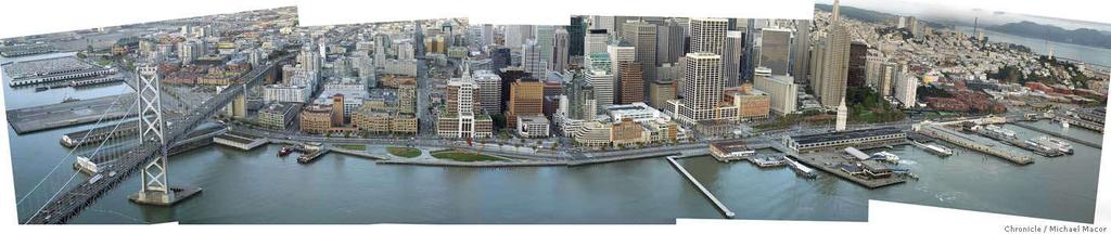
65 Embarcadero ramps removal, 1991 Source: Amit Ghosh, San Francisco Planning Department


66 Source: Amit Ghosh, San Francisco Planning Department

67 Alternative Concept for Embarcadero Tunnel Source: Amit Ghosh, San Francisco Planning Department

68 Source: Amit Ghosh, San Francisco Planning Department

69 Source: Amit Ghosh, San Francisco Planning Department

70 Source: Amit Ghosh, San Francisco Planning Department

71 Source: Amit Ghosh, San Francisco Planning Department

72 San Francisco waterfront
73

74


75 24

76 Housing units up 54%, (a 74% increase above Results nearby control areas) Jobs up 23%, (a 318% increase above nearby control areas) 75% increase in transit commute trips Freeway reduced home values by average of $118,000 From Elevated Freeways to Surface Boulevards: Neighborhood, Traffic, and Housing Price Impacts in San Francisco, by Robert Cervero, Junhee Kang, and Kevin Shively. Department of City and Regional Planning University of California, Berkeley, December 2007.


77 Central Freeway removal Source: Amit Ghosh, San Francisco Planning Department


78 Octavia Boulevard, Before Source: Amit Ghosh, San Francisco Planning Department

79 Octavia Boulevard, After Octavia Boulevard Redesign Steve Boland, Nelson\Nygaard

80 Octavia Boulevard Freeway built 1959 Damaged 1989 Upper deck removed 1996 Third vote for boulevard, 1999 Final demolition, 2003 Boulevard open 2005 Before replacement, carried 90,000 cars per day Octavia: 45,000 cars per day September headline of the San Francisco Chronicle : Traffic Planners Baffled by Success: No Central Freeway, No Gridlock, and No Explanation. From Elevated Freeways to Surface Boulevards: Neighborhood, Traffic, and Housing Price Impacts in San Francisco, by Robert Cervero, Junhee Kang, and Kevin Shively. Department of City and Regional Planning University of California, Berkeley, December 2007.

81 Octavia Boulevard Freeway reduced home values an average of $116,000 With freeway: Housing prices 66% of median; after: 91% of median. Nearly 1,000 new housing units, of which half are permanently affordable. From Elevated Freeways to Surface Boulevards: Neighborhood, Traffic, and Housing Price Impacts in San Francisco, by Robert Cervero, Junhee Kang, and Kevin Shively. Department of City and Regional Planning University of California, Berkeley, December 2007.
82 Caution: Social Equity After boulevard, 12% increase in whites, and 33% decrease in African American residents in neighborhood. To minimize displacement and provide advantages for existing residents: Capture property value increase and invest in existing businesses, cultural institutions, neighborhood stabilization. Limit gentrification by zoning for smaller units, less parking. Invest in permanently affordable housing. Form neighborhood nonprofits and direct resources to them. Ensure that impetus for change arises from within the neighborhood.

83 What happened to Central Freeway traffic? Traffic on alternate routes increased by no more than 10% San Francisco Department of Park and Traffic, 2006

84 Image: sfcityscape

85 Image: sfcityscape

86 Image: sfcityscape

87 Image: sfcityscape

88 Image: sfcityscape

89 Image: sfcityscape
90 Freeway Challenges: Traffic Impacts Major Advantage: Speed, Especially for Long Distance Travel Major Disadvantage: Local Access Constraint Freeway capacity limited by capacity of ramps where freeway meets city grid. Freeways don t always increase network capacity they may simply move the traffic bottleneck from one place to another. If freeways interrupt the city street grid, they may remove as much network capacity as they create

91 Abu Dhabi: Low Connectivity 18 lanes of through traffic Up to 2,000 vehicles per lane hour Abu Dhabi: Limited Up Connectivity to 36,000 vehicles per hour

92 Vancouver: High Connectivity 100 lanes of through traffic Up to 700 vehicles per lane hour Up to 70,000 vehicles per hour No freeways = twice the capacity!
93 Freeway Challenges: Economic Impacts Major Advantage: Real Estate Value Freeways create real estate value for auto dependent, far away places by providing speedy access to jobs and services Major Disadvantage: Real Estate Value Freeways reduce real estate value around them by eliminating direct access and increasing noise Typically, urban freeways may cut adjacent real estate value by half; removing freeways doubles adjacent real estate value (Milwaukee, San Francisco data);
94 Freeway Challenges: Social Impacts Major Advantage: Convenience for Cars High speed, simple connections for cars Major Disadvantage: All other Modes Urban freeways make walking uncomfortable, dangerous and/or impossible If passengers can t cross the street, transit does not work By excluding other modes, freeways increase the auto trip generation rate, meaning new capacity may be filled because more people must drive.

95
96 Jeff Tumlin 116 New Montgomery Street, Suite 500 San Francisco, CA NELSON\NYGAARD CONSULTING ASSOCIATES 2012
97 Creating Livable Streets and Corridors (S526) Washington State s Experience Paula Reeves Manager, Community Design WSDOT s Highways & Local Programs Division American Planning Association Conference Los Angeles, CA April 16, 2012
98 Key Topics Creating livable streets Washington example Working with State DOT s Recent projects success stories
99 What steps are we taking? Developing new policies and guides (planning, design, construction and maintenance) Restructuring procedures to accommodate all users Offering workshops and other trainings Instituting better ways to measure performance Developing a project funding mechanism
100 Milestones in State Policy WSDOT Livable Communities Policy, 2000 CSS Executive Order, 2003 Design Guidance and Training, 2005 Understanding Flexibility in Transportation, Washington State Funding for Pedestrian & Bicycle Safety, 2005 AASHTO Environmental Excellence Award, 2006 Best Organizational Integration of Context Sensitive Design State Bicycle and Pedestrian Plan adopted, 2008 Complete Streets Bill (ESHB 1071) passed, 2011 Flexible Design Bill (HB 1700) passed,
101 Recent Milestones in Federal Policy Federal Highway Administration Issues Livable Communities Policy, June USDOT Policy on Biking and Walking, March FHWA applies Livable Communities criteria to all discretionary grant programs: --Provide more transportation choices. --Promote equitable, affordable housing. --Enhance economic competitiveness. --Support existing communities. --Coordinate policies and leverage investment. --Value communities and neighborhoods.


102 WSDOT Community Design Developing Streets for Everyone

103 Typical Complete Street Elements Source: Association of Washington Cities

104 Study: State Highways as Main Streets The Issues City streets operate as state highways Design affects community livability and safety Scope, schedule and budget changes on these streets/highways

105 The Research 1. System Analysis 2. Case Studies Storefront Studio Program University of Washington College of Built Environments Department of Architecture
106 Variables What s a Main Street Highway? Step 1: Screening State Route within City Limits Y, N Highway of Statewide Significance Y, N National Highway System Y, N State Access Control Classification Y, N Federal Functional Classification Design Speed Posted Speed Year of Incorporation Freight Classification Collision History Units of Measure Principal arterials, Minor arterial streets, Collector streets, Local streets MPH MPH Year T-1 more than 10 million tons per year; T-2 4 million to 10 million tons per year; T-3 300,000 to 4 million tons per year; T-4 100,000 to 300,000 tons per year; T-5 at least 20,000 tons in 60 days Number of collisions involving bicyclists and pedestrians
107 Step 2 Defining Main Street Highways Variables Units of Measure Proportion of visible buildings that are commercial Percentage (25%, 50%, 75%, 100%) Proportion of street frontage with dead space Percentage (25%, 50%, 75%, 100%) Proportion of street frontage with parked cars Percentage (25%, 50%, 75%, 100%) Proportion of street frontage with tree canopy Percentage (25%, 50%, 75%, 100%) Number of travel lanes Number both directions Average travel lane width Feet Average shoulder width Feet Average median width Feet Average sidewalk width Feet Total curb to curb width Feet Total back of sidewalk to back of sidewalk width Feet Posted speed limit MPH Crosswalk spacing Feet Visible curb extensions (y, n) Y,N Average building setback Feet Average building height (stories) Stories Uniform building height (y, n)) Y,N Number of pedestrians visible Count Average daily traffic Volume Visible bicycle lane Y,N Visible buildings that are historic Y,N

108
109 Findings Scope changes: -- More common on Main Street Highways -- 48% of all projects vs. 38% on other parts of the state system Retrospective review: projects or 20% of WSDOT s scope, schedule and budget changes could have directly benefited from additional community design Average estimated saving per project: -- Over $9 million dollars or 30% of project cost

 Example: State Route 14")
110 Implementing the Research New Funding Program Complete Streets (2011 Washington Legislation ESHB 1071) New Design Approach (2012 Washington Legislation HB 1700) Example: State Route 14 Bingen

111 Working with State DOT s on joint projects Locate your advocate within the State DOT -Often the office administering federal aid Communicate early and often -Understand what is in plans and standards Anticipate a review process Involve the public in your project DO NOT give up -Where there is a will there is a way Clarify expectations, roles and responsibilities -Different goals? -Who is the general contractor? -Use a master contract for joint projects


112 Recent Success Stories Before Haxton Way, Whatcom County, WA After


113 Before State Route 99 - Des Moines, WA After


114 Before After Factoria Trail I Bellevue, WA


115 Before State Route Carnation, WA After
116 WSDOT Resources & Contacts WSDOT s Complete Streets website UW Storefront Studio website State Highways as Main Streets: A Study of Community Design and Visioning Paula Reeves Manager, Community Design Assistance Reevesp@wsdot.wa.gov,
WSDOT s Main Street Highways Initiative
 WSDOT s Main Street Highways Initiative Paula Reeves, AICP CTP WSDOT Highways and Local Programs Reconnecting America Webinar October 16 th, 2013 WSDOT s Local Programs Division We provide educational,
AMATS Complete Streets Policy
 AMATS Complete Streets Policy Table of Contents: Section 1. Definition of Complete Streets Section 2. Principles of Complete Streets Section 3. Complete Streets Policy Section 4. Consistency Section 5.
Proposed. City of Grand Junction Complete Streets Policy. Exhibit 10
 Proposed City of Grand Junction Complete Streets Policy Exhibit 10 1 City of Grand Junction Complete Streets Policy Vision: The Complete Streets Vision is to develop a safe, efficient, and reliable travel
CITY OF BLOOMINGTON COMPLETE STREETS POLICY
 CITY OF BLOOMINGTON COMPLETE STREETS POLICY POLICY OBJECTIVE: The City of Bloomington will enhance safety, mobility, accessibility and convenience for transportation network users of all ages and abilities,
RESOLUTION NO ?? A RESOLUTION OF THE CITY OF NEPTUNE BEACH ADOPTING A COMPLETE STREETS POLICY
 RESOLUTION NO. 2018-?? A RESOLUTION OF THE CITY OF NEPTUNE BEACH ADOPTING A COMPLETE STREETS POLICY WHEREAS, safe, convenient, and accessible transportation for all users is a priority of the City of Neptune
Transportation Master Plan Advisory Task Force
 Transportation Master Plan Advisory Task Force Network Alternatives & Phasing Strategy February 2016 BACKGROUND Table of Contents BACKGROUND Purpose & Introduction 2 Linking the TMP to Key Council Approved
Vision: Traditional hamlet with an attractive business/pedestrian friendly main street connected to adjacent walkable neighborhoods
 N D. Focus Area II Vision: Traditional hamlet with an attractive business/pedestrian friendly main street connected to adjacent walkable neighborhoods Transit Road Focus Area II is located in the Hamlet
CONNECTING PEOPLE TO PLACES
 CONNECTING PEOPLE TO PLACES 82 EAST BENCH MASTER PLAN 07 Introduction The East Bench transportation system is a collection of slow moving, treelined residential streets and major arteries that are the
Perryville TOD and Greenway Plan
 Perryville TOD and Greenway Plan Greenway Glossary Pathway: A bicycle and pedestrian path separated from motorized vehicular traffic by an open space, barrier or curb. Multi-use paths may be within the
Welcome. Background. Goals. Vision
 Welcome The formal Public Information Centre (PIC) for the Transportation Master Plan How We GO will be held in early 2017. At that time we will present the recommended transportation system for Niagara
ACTIVE TRANSPORTATION
 ACTIVE TRANSPORTATION Mobility 2040 Supported Goals Improve the availability of transportation options for people and goods. Support travel efficiency measures and system enhancements targeted at congestion
DRAFT MOVING FORWARD RHODE ISLAND BICYCLE MOBILITY PLAN 2018 PREPARED FOR PREPARED BY IN ASSOCIATION WITH
 RHODE ISLAND MOVING FORWARD BICYCLE MOBILITY PLAN 2018 PREPARED FOR PREPARED BY IN ASSOCIATION WITH T AF CHAPTER 1 D R INTRODUCTION CHAPTER 3 ARTICULATES VISION Bicycling is safe, fun and practical in
Linking Transportation and Health in Nashville & Middle Tennessee
 Linking Transportation and Health in Nashville & Middle Tennessee Fit Nation New Orleans CPPW Mentoring Grant Built Environment Program May 14, 2011 Local Transportation Planning Framework Federal U.S.
Brian D. Hare, P.E. Bureau of Design PennDOT PA APA Annual Conference Investing in a Sustainable Future October 5, 2009
 Brian D. Hare, P.E. Bureau of Design PennDOT 2009 PA APA Annual Conference Investing in a Sustainable Future October 5, 2009 1 What is Smart Transportation? Photographer: heyjude. Used through license
7 Complete Streets & Roadway Aesthetics
 7 Complete Streets & Roadway Aesthetics 7.1 OVERVIEW Our streets lay the foundation for how we interface with travel needs, physical exercise, social exchanges and access to goods and services. They are
REGIONAL BICYCLE AND PEDESTRIAN DESIGN GUIDELINES
 REGIONAL BICYCLE AND PEDESTRIAN DESIGN GUIDELINES November 16, 2011 Deb Humphreys North Central Texas Council of Governments Bicycle and Pedestrian Advisory Committee Snapshot of the Guide 1. Introduction
Performance measures for nonmotorized
 Performance measures for nonmotorized transportation May 2, 2014 Performance measures for non-motorized transportation Today s Speakers Robbie Webber State Smart Transportation Initiative Craig Williams
Living Streets Policy
 Living Streets Policy Introduction Living streets balance the needs of motorists, bicyclists, pedestrians and transit riders in ways that promote safety and convenience, enhance community identity, create
Exhibit 1 PLANNING COMMISSION AGENDA ITEM
 Exhibit 1 PLANNING COMMISSION AGENDA ITEM Project Name: Grand Junction Circulation Plan Grand Junction Complete Streets Policy Applicant: City of Grand Junction Representative: David Thornton Address:
Fargo Moorhead Metropolitan Area Complete Streets Policy Statement
 Fargo Moorhead Metropolitan Area Complete Streets Policy Statement Approved by the Fargo Moorhead Metropolitan Council of Governments Policy Board on November 18, 2010 1. Purpose The term Complete Streets
Thank you for this opportunity to discuss with you how we can work together to make our streets more complete.
 Thank you for this opportunity to discuss with you how we can work together to make our streets more complete. 1 2 3 Thank you for this opportunity to discuss with you how we can work together to make
complete streets design and construction standards public primer City of Edmonton
 complete streets design and construction standards public primer City of Edmonton introduction Complete Streets are streets for everyone: people who walk, wheel, bike, take transit, or drive. They are
INDOT Complete Streets Guideline & Policy
 INDOT Complete Streets Guideline & Policy INTRODUCTION The Complete Streets guidelines build upon multiple efforts and promote a multimodal transportation system that is integrated and sustains land use
COMPLETE STREETS POLICY Exhibit A to Ordinance
 CITY OF WENATCHEE COMPLETE STREETS POLICY Exhibit A to Ordinance 2016-24 Prepared and Reviewed By: City of Wenatchee Community & Economic Development Department City of Wenatchee Public Works Department
Performance Criteria for 2035 Long Range Transportation Plan
 Minimizing Impacts on Natural, Historic, Cultural or Archeological Resources 2035 LRTP Weighting Factor: 7% Objective 1.1: Use appropriate planning and design criteria to protect and enhance the built
Bicycle Master Plan Goals, Strategies, and Policies
 Bicycle Master Plan Goals, Strategies, and Policies Mobilizing 5 This chapter outlines the overarching goals, action statements, and action items Long Beach will take in order to achieve its vision of
CITY OF COCOA BEACH 2025 COMPREHENSIVE PLAN. Section VIII Mobility Element Goals, Objectives, and Policies
 CITY OF COCOA BEACH 2025 COMPREHENSIVE PLAN Section VIII Mobility Element Goals, Objectives, and Policies Adopted August 6, 2015 by Ordinance No. 1591 VIII MOBILITY ELEMENT Table of Contents Page Number
Berkeley Strategic Transportation Plan A-76
 Berkeley Strategic Transportation Plan A-76 Appendices 1. A Team Effort 2. Where We ve Been A-11 Berkeley Strategic Transportation Plan Alameda County Transportation Plan Alameda County will be served
TOWN OF PORTLAND, CONNECTICUT COMPLETE STREETS POLICY
 TOWN OF PORTLAND, CONNECTICUT COMPLETE STREETS POLICY I. VISION, GOALS & PRINCIPLES VISION To improve the streets of Portland making them safer and more accessible for all users including pedestrians,
Solana Beach Comprehensive Active Transportation Strategy (CATS)
") Solana Beach Comprehensive Active Transportation Strategy (CATS) 3.0 Goals & Policies The Solana Beach CATS goals and objectives outlined below were largely drawn from the Solana Beach Circulation Element
Solana Beach Comprehensive Active Transportation Strategy (CATS) 3.0 Goals & Policies The Solana Beach CATS goals and objectives outlined below were largely drawn from the Solana Beach Circulation Element
Clackamas County Comprehensive Plan
 ROADWAYS The County s road system permits the movement of goods and people between communities and regions, using any of a variety of modes of travel. Roads provide access to virtually all property. They
Complete Streets Workshop Follow-up. April 27, 2011 Rockledge City Hall
 Complete Streets Workshop Follow-up April 27, 2011 Rockledge City Hall Agenda Complete Streets draft briefing presentation and sample policy language Share your Complete Streets projects and post workshop
Report. Typical Sections. City of Middleton, WI
 Report Typical Sections City of Middleton, WI December 2006 Report for City of Middleton, Wisconsin Typical Sections repared by: Traffic Associates LLC and STRAND ASSOCIATES, INC. 910 West Wingra Drive
Omaha s Complete Streets Policy
 Omaha s Complete Streets Policy (Adopted August 2015) VISION To create great places and enhance our quality of life, the City of Omaha will provide safe, accessible streets for all users. Complete Streets
Appendix 3 Roadway and Bike/Ped Design Standards
 Appendix 3 Roadway and Bike/Ped Design Standards OTO Transportation Plan 2040 4/20/2017 Page A3-1 Adopted Standards The adopted OTO Design Standards and Major Thoroughfare Plan are contained herein.
City of Jacksonville Mobility Fee Update
 City of Jacksonville Mobility Fee Update 2017 Preliminary Analysis May 3, 2017 Carnival Cruise lines photo credit Presentation Overview Public Outreach Process Pedestrian and Bicycle Master Plan Study
Circulation in Elk Grove includes: Motor vehicles, including cars and trucks
 Circulation, as it is used in this General Plan, refers to the many ways people and goods move from place to place in Elk Grove and the region. Circulation in Elk Grove includes: Motor vehicles, including
EXECUTIVE SUMMARY. Vision
 Vision Walking and bicycling in Salt Lake City will be safe, convenient, comfortable, and viable transportation options that connect people to places, foster recreational and economic development opportunities,
Chapter 2. Bellingham Bicycle Master Plan Chapter 2: Policies and Actions
 Chapter 2 Bellingham Bicycle Master Plan Chapter 2: Policies and Actions Chapter 2: Policies and Actions The Bicycle Master Plan provides a road map for making bicycling in Bellingham a viable transportation
Executive Summary Route 30 Corridor Master Plan
 Route Corridor Master Plan Project Overview The Route Corridor Master Plan is a coordinated multimodal transportation and land use plan for the entire stretch of Route through East Whiteland Township,
Illustrated Principles of Good Planning
 Illustrated Principles of Good Planning The Miami 21 Zoning Code incorporates time-tested planning principles into the zoning regulations of our City. These are principles that make for better neighborhoods,
Bicycle Lanes Planning, Design, Funding South Mountain Partnership Trails Workshop Roy Gothie PennDOT Statewide Bicycle Pedestrian Coordinator
 Bicycle Lanes Planning, Design, Funding 2018 South Mountain Partnership Trails Workshop Roy Gothie PennDOT Statewide Bicycle Pedestrian Coordinator Policy Changes: BOP Bicycle Policy Changes The OLD Way
Moving Cambridge. City of Cambridge Transportation Master Plan Public Consultation Centre. March 7, :00 8:00 PM.
 City of Cambridge Transportation Master Plan Public Consultation Centre March 7, 2018 5:00 8:00 PM Region of Waterloo City of Cambridge Transportation Master Plan Public Consultation Centre March 7, 2018
Chapter 7. Transportation. Transportation Road Network Plan Transit Cyclists Pedestrians Multi-Use and Equestrian Trails
 Chapter 7 Transportation Transportation Road Network Plan Transit Cyclists Pedestrians Multi-Use and Equestrian Trails 7.1 TRANSPORTATION BACKGROUND The District of Maple Ridge faces a number of unique
Moving Towards Complete Streets MMLOS Applications
 Moving Towards Complete Streets MMLOS Applications Transportation Education Series May 18 th, 2012 It s not just for cars! Presentation Overview The Complete Streets Movement What is Multi-Modal Level
CHAPTER 7.0 IMPLEMENTATION
 CHAPTER 7.0 IMPLEMENTATION Achieving the vision of the Better Streets Plan will rely on the ability to effectively fund, build and maintain improvements, and to sustain improvements over time. CHAPTER
WELCOME TO OPEN HOUSE # 1 June 14, 2017
 Langstaff Road Weston Road to Highway 7 Class Environmental Assessment Study WELCOME TO OPEN HOUSE # 1 June 14, 2017 Please sign in and join our mailing list Purpose of Open House #1 & Study Area York
Multimodal Through Corridors and Placemaking Corridors
 68 Multimodal Through Corridors and Placemaking Corridors Corridors have different functions in a region. Some corridors are used to get smoothly and rapidly through a region or to get quickly to major
We believe the following comments and suggestions can help the department meet those goals.
 The Honorable Secretary Anthony Foxx The Secretary of Transportation United States Department of Transportation 1200 New Jersey Avenue, SE Washington, DC 20590 August 30, 2013 Dear Secretary Foxx, Thank
Tonight is for you. Learn everything you can. Share all your ideas.
 Strathcona Neighbourhood Renewal Draft Concept Design Tonight is for you. Learn everything you can. Share all your ideas. What is Neighbourhood Renewal? Creating a design with you for your neighbourhood.
APPENDIX A: Complete Streets Checklist DRAFT NOVEMBER 2016
 APPENDIX A: Complete Streets Checklist DRAFT NOVEMBER 2016 Complete Streets Checklist MetroPlan Orlando s Complete Streets Checklist is an internal planning tool for staff to further implementation of
Vision to Action Community Coalition February 14, 2014 Briefing
 Vision to Action Community Coalition February 14, 2014 Briefing Transportation and Transit Planning & Mass Transit Operations Strategic Growth Area Office Brian S. Solis Transportation & Transit Manager
Environmental Assessment Findings & Recommendations. Public Hearing November 13, 2014
 Environmental Assessment Findings & Recommendations Public Hearing November 13, 2014 Welcome! Welcome and Introductions Project and Environmental Assessment Overview Public Comments Adjourn Purpose of
CSS and Complete Streets Partnering with Mn/DOT for Complete Streets. Scott Bradley Director of CSS April 27, 2010 CTS Research Conference
 CSS and Complete Streets Partnering with Mn/DOT for Complete Streets Scott Bradley Director of CSS April 27, 2010 CTS Research Conference What s The Fuss About Context Sensitive Solutions & Complete Streets
Planning Regionally With Transit
 Planning Regionally With Transit Nathan Coats Director of Operations CTAA Expo 2015 Tampa Began 1992. Serves eastern Cache County to Preston, ID. Population- 115,000 34 bus fleet, 26 fixed route buses;
City of Novi Non-Motorized Master Plan 2011 Executive Summary
 City of Novi Non-Motorized Master Plan 2011 Executive Summary Prepared by: February 28, 2011 Why Plan? Encouraging healthy, active lifestyles through pathway and sidewalk connectivity has been a focus
MnDOT Implementation of Complete Streets Policy. January 2014
 MnDOT Implementation of Complete Streets Policy January 2014 1 Prepared by Minnesota Department of Transportation 395 John Ireland Boulevard Saint Paul, Minnesota 55155-1899 Phone: 651-296-3000 Toll-Free:
West Dimond Blvd Upgrade Jodhpur Street to Sand Lake Road
 West Dimond Blvd Jodhpur St to Sand Lake CSS Transportation Project Summary Municipality of Anchorage Project # 05 005 Project Manager: John Smith, P.E. (MOA PM&E) Project Administrator: Julie Makela,
Walkable Communities: National Best Practices and Applications in Memphis, TN
 Walkable Communities: National Best Practices and Applications in Memphis, TN Dr. Stephanie Ivey Assistant Professor Herff College of Engineering Department of Civil Engineering Agenda Walkable communities
How To Encourage More Efficient Transportation in Brazilian Cities
 How To Encourage More Efficient Transportation in Brazilian Cities Todd Litman Victoria Transport Policy Institute Presented Seminar on Discouraging The Use Of Cars São Paulo, Brazil 3 September 2013 Creating
Ann Arbor Downtown Street Plan
 1 Ann Arbor Downtown Street Plan Public Workshop #1 We know that. 2 Public right-of-way (streets, sidewalks, and alleys) make up 30% of the total District area of downtown. Streets need to provide mobility
Creating Complete Streets to Accommodate All Users
 Creating Complete Streets to Accommodate All Users Peter Lagerwey, Toole Design Group plagerwey@tooledesign.com Brian Dougherty, Seattle DOT brian.dougherty@seattle.gov International Conference on Urban
Prioritizing Transportation Policy and Funding for Active Transportation, Safety, Equity and Health
 Mayor Karl Dean, Chairman Prioritizing Transportation Policy and Funding for Active Transportation, Safety, Equity and Health Leslie A. Meehan, AICP Planning and Implementing the Active Community Webinar
Defining Purpose and Need
 Advanced Design Flexibility Pilot Workshop Session 4 Jack Broz, PE, HR Green May 5-6, 2010 Defining Purpose and Need In your agency s project development process, when do design engineers typically get
Environment and Public Works Committee Presentation
 Mixed Use Centers Complete Streets Guidelines Project Environment and Public Works Committee Presentation December 10, 2008 Project Objectives: Conduct an inter-departmental and agency process to study
Appendix C 3. Bicycle / Pedestrian Planning
 Appendix C 3. Bicycle / Pedestrian Planning BICYCLE/PEDESTRIAN PLANNING 2005 Master Plan GOAL: Provide for safe and convenient bicycle and pedestrian circulation throughout the City. Develop a city-wide
Item to be Addressed Checklist Consideration YES NO N/A Required Description Complete Streets Guidelines
 Passaic County Complete Streets Checklist - Concept Development Project Name Item to be Addressed Checklist Consideration YES NO N/A Required Description Complete Streets Guidelines Existing Plans Have
Complete Streets. Designing Streets for Everyone. Sarnia
 Complete Streets Designing Streets for Everyone Sarnia Complete Streets ~ Sarnia ~ 2018 Introduction Our City is made up of a network of streets that we use to go for a walk, cycle to work, drive to the
12/4/2016 VIA . RE: Grocery Outlet Del Paso (DR16-328)
") 12/4/2016 VIA EMAIL Ethan Meltzer, Assistant Planner City of Sacramento Community Development Department 300 Richards Blvd, 3 rd Floor Sacramento, CA 95811 RE: Grocery Outlet Del Paso (DR16-328) Dear Mr.
12/4/2016 VIA EMAIL Ethan Meltzer, Assistant Planner City of Sacramento Community Development Department 300 Richards Blvd, 3 rd Floor Sacramento, CA 95811 RE: Grocery Outlet Del Paso (DR16-328) Dear Mr.
10.0 CURB EXTENSIONS GUIDELINE
 10.0 CURB EXTENSIONS GUIDELINE Road Engineering Design Guidelines Version 1.0 March 2017 City of Toronto, Transportation Services City of Toronto Page 0 Background In early 2014, Transportation Services
MCTC 2018 RTP SCS and Madera County RIFP Multi-Modal Project Eval Criteria GV13.xlsx
 MCTC 8 RTP SCS and Madera County RIFP Multi-Modal Project Eval Criteria GV.xlsx Madera County Transportation Commission Regional Transportation Plan / Sustainable Communities Strategy Multi-Modal Project
Complete Streets Training. Georgia Municipal Association June 27, 2016
 Complete Streets Training Georgia Municipal Association June 27, 2016 Overview What are CS? GDOT s Policy Case Study 2 What are Complete Streets? According to the National Complete Streets Coalition, complete
PEDALING FORWARD. A Glance at the SFMTA s Bike Program for SFMTA.COM
 PEDALING FORWARD A Glance at the SFMTA s Bike Program for 2017-2021 SFMTA.COM INTRODUCTION About This Booklet More people from all walks of life see their bicycle as a more convenient way to get where
General Plan Circulation Element Update Scoping Meeting April 16, 2014 Santa Ana Senior Center, 424 W. 3rd Street, Santa Ana, CA 92701
 General Plan Circulation Element Update Scoping Meeting April 16, 2014 Santa Ana Senior Center, 424 W. 3rd Street, Santa Ana, CA 92701 Meeting Agenda 1. Purpose of Scoping Meeting 2. Project Overview 3.
Table #6 VISION CHARACTERISTICS
 Table #6 VISION White Flint is a place to live, work, play, shop, and walk with sufficient density to encourage quality redevelopment. Vibrant streets and consistent streetscapes are important. CHARACTERISTICS
2015 Florida Main Street Annual Conference. Complete Streets Equal Stronger Main Streets
 WHAT ARE COMPLETE STREETS? CASE STUDIES COMPLETING YOUR MAIN STREET 2015 Florida Main Street Annual Conference St. Petersburg, Florida August 19, 2015 WHAT ARE COMPLETE STREETS? CASE STUDIES COMPLETING
Regional Transportation Needs Within Southeastern Wisconsin
 Regional Transportation Needs Within Southeastern Wisconsin #118274 May 24, 2006 1 Introduction The Southeastern Wisconsin Regional Planning Commission (SEWRPC) is the official areawide planning agency
PEDESTRIAN ACTION PLAN
 ATTACHMENT 2 CITY OF SANTA MONICA PEDESTRIAN ACTION PLAN CITY OF SANTA MONICA PEDESTRIAN ACTION PLAN This page intentionally left blank EXECUTIVE SUMMARY CHAPTER 1 EXECUTIVE SUMMARY Setting the Stage
What Is a Complete Street?
 Session 5 Charleen Zimmer, AICP, Zan Associates May 5-7, 2010 What Is a Complete Street? May 2010 5-1 Not a Complete Street More of a Complete Street May 2010 5-2 Benefits of Complete Streets Safety for
Chapter 9: Pedestrians and Bicyclists
 Chapter 9: Pedestrians and Bicyclists Walking and bicycling are essential modes of transportation. These modes allow people to travel without contributing to congestion and air pollution, to access other
Complete Streets Policy DAVID CRONIN, P.E., CITY ENGINEER
 Complete Streets Policy DAVID CRONIN, P.E., CITY ENGINEER Complete Streets City Commission adopted a Complete Streets policy in 2012 Complete Streets are road networks that are designed for all users:
Arlington s Master Transportation Plan
 Arlington s Master Transportation Plan The Master Transportation Plan (MTP) Adopted in eight parts Goals & Policies element and MTP Map adopted in 2007 Bicycle, Pedestrian and Demand and Systems Management
Purpose and Need. Chapter Introduction. 2.2 Project Purpose and Need Project Purpose Project Need
 Chapter 2 Purpose and Need 2.1 Introduction The El Camino Real Bus Rapid Transit (BRT) Project (Project) would make transit and other transportation improvements along a 17.6-mile segment of the El Camino
TRANSPORTATION TRAINING TOPICS. April 6, 2010
 TRANSPORTATION TRAINING TOPICS April 6, 2010 Roles of Transportation Providers Context and Policy Makers Division of Transportation and Traffic Other City Operations Other Transportation Operators CMA
Classification Criteria
 SCHEDULE D TO RECOMMENDED OFFICIAL PLAN AMENDMENT NO. 40 SCHEDULE C-4 Road Criteria Criteria Traffic Service Objective Land Service/Access Typical Daily Traffic Volume Flow characteristics Travel Speed
Bicycle and Pedestrian Chapter TPP Update Overview. TAB September 20, 2017
 Bicycle and Pedestrian Chapter TPP Update Overview TAB September 20, 2017 Bicycling & Walking in the Twin Cities Where are we now? The Bike-Pedestrian system Current trends New developments Where are we
T1-A - Service Reduction (Re-sizing)
") Key T1-A Choice A Key T1-B Choice B Key T1-C Choice C Key T1-D Choice D Key T1-E Choice E Key T1-F Choice F Key Choice G T2 T1-A - Service Reduction (Re-sizing) Description This key choice would represent
Key T1-A Choice A Key T1-B Choice B Key T1-C Choice C Key T1-D Choice D Key T1-E Choice E Key T1-F Choice F Key Choice G T2 T1-A - Service Reduction (Re-sizing) Description This key choice would represent
In station areas, new pedestrian links can increase network connectivity and provide direct access to stations.
 The Last Mile Planning for Pedestrians Planning around stations will put pedestrians first. Making walking to stations safe and easy is important; walking will be a part of every rapid transit Accessible
Bellevue Transportation: Challenges, Opportunities and Priorities Bellevue Downtown Association September 20, 2018
 Bellevue Transportation: Challenges, Opportunities and Priorities Bellevue Downtown Association September 20, 2018 Dave Berg Transportation Director City of Bellevue Traffic, traffic and more traffic!
5.0 Roadway System Plan
 Southwest Boise Transportation Study Page 16 5.0 Roadway System Plan The Roadway System Plan outlines roadway improvements in the Initial Study Area. It forecasts future deficiencies on the arterial system,
Vision Public Workshop: Findings
 Vision Public Workshop: Findings Long Range Transportation Plan & Bicycle Mobility Plan February 2018 Vision Workshop South Kingstown 1/23/18 Providence 1/24/18 Newport 1/31/18 Long Range Transportation
Goal 3: Foster an environment of partnerships and collaboration to connect our communities and regions to one another.
 Non-Motorized Transportation Plan (NMTP) Draft Vision, Goal and,, Tri-County Regional Planning Commission (TCRPC) Purpose The purpose of the Tri-County Regional Planning Commission (TCRPC) Non-Motorized
San Jose Transportation Policy
 San Jose Transportation Policy Protected Intersections in LOS Policies to Support Smart Growth Presented by: Manuel Pineda City of San Jose Department of Transportation Bay Area Map San Francisco Oakland
BUILDING THE CASE FOR TRAVEL OPTIONS IN WASHING TON COUNTY. Image: Steve Morgan. Image: Steve Morgan
 BUILDING THE CASE FOR TRAVEL OPTIONS IN WASHING TON COUNTY Image: Steve Morgan Image: Steve Morgan Image: TriMet Image: TriMet WHAT ARE TRAVEL OPTIONS PROGRAMS? Travel options programs encourage residents,
FOR INFORMATION ONLY
 9 Date: August 6, 2012 Current Meeting: August 16, 2012 Board Meeting: September 6, 2012 BOARD MEMORANDUM TO: THROUGH: FROM: SUBJECT: Santa Clara Valley Transportation Authority Congestion Management Program
MIXED USE AND STREETSCAPE INTEGRATION Avondale Will Basil Juliana Zannotto
 MIXED USE AND STREETSCAPE INTEGRATION Avondale Will Basil Juliana Zannotto Creating new development so that people will stop and see what Avondale has to offer The goal for my project was simple. I wanted
Active Transportation Infrastructure Investment A Business Case
 Active Transportation Infrastructure Investment A Business Case In 2016, the Real Estate Foundation awarded the Capital Regional District a $50,000 grant for Shifting Gears: Land Use Change through Active
CURBSIDE ACTIVITY DESIGN
 5 CURBSIDE ACTIVITY DESIGN This chapter provides design guidance for separated bike lanes adjacent to curbside activities including parking, loading and bus stops. Typical configurations are presented
TOWN OF CHAPEL HILL NORTH CAROLINA
 8 TOWN OF CHAPEL HILL NORTH CAROLINA EXECUTIVE SUMMARY Meeting Date: 1/19/2011 AGENDA #2 Title of Agenda Item: Complete Streets Policy Update. Council Goal: Focus on Economic Development, Land Use, and
Route 7 Corridor Study
 Route 7 Corridor Study Executive Summary Study Area The following report analyzes a segment of the Virginia State Route 7 corridor. The corridor study area, spanning over 5 miles in length, is a multi