Pedestrian Data Collection and Consistency in Open Street Maps. April 20, 2018
|
|
|
- Edgar Cook
- 5 years ago
- Views:
Transcription


1 Pedestrian Data Collection and Consistency in Open Street Maps April 20, 2018
2 The Goal Data Collection and Consistency Obtain regionally consistent pedestrian asset data that supports: potential model improvements for pedestrian travel plan monitoring consistent evaluation of pedestrian connectivity needs region-wide the preservation and maintenance work program local needs


3 Transit Access Assessments Sound Transit and King County Metro study Analysis included: Intersection Density Route directness Signalized Arterial Crossings Sidewalk Coverage Projected increase in transit ridership Bike Stress Composite Connectivity Index
4 The Challenge Inconsistent data formats between jurisdictions data sets are difficult to integrate Inconsistent information different data points are collected and not consistent regionally Lack of data in some areas Longevity of data collection activities and updates Challenge of sharing and accessing data in one place

5 The Challenge Sidewalk Data Set Example: Inconsistent data formats and lack of detailed information Polygons Lines on both sides Center line with L/R attributes PDF map No additional data
6 Step 1: Sidewalk Network in OSM Start with entering sidewalk data into Open Street Maps (OSM) 1. Begin with access to transit locations 2. Prioritize where to begin: not to overlap what other agencies are doing suggest high capacity transit and ferries to start 3. Decide on the method: sidewalks as metadata to roads vs. sidewalks mapped as ways 4. Identify process (bulk import or manual coding) 5. Define essential tags that are needed for step 1 6. Get started
7 Why PSRC is choosing Open Street Maps Existing transit networks and tools already use OSM networks Open source opportunity for PSRC and partners to collectively contribute to one data set Data in OSM would benefit from analysis tools developed or being developed (AccessMap) Provides interoperability and maintainability

8

9 TriMet and OpenStreetMap Madeline Steele TriMet provides transit in Portland, Oregon region Leaders in open source tools/data Helped launch OpenTripPlanner (OTP) in 2009 Adopted OSM in 2011
10 Street Data Comparison - why TriMet chose OSM Commercial Costly Limited control over data quality and updates Centerline Files Free Limited coverage area Not designed for routing purposes OpenStreetMap Free Seamless coverage worldwide Designed for and supports multimodal routing Investment in community product for shared benefits More control, higher quality
 OpenStreetMap Contributors.")
11 Sidewalk Project Colored streets have sidewalk tags TriMet 2016 sidewalk tagging PBOT Growing Transit Communities Pilot Tagged before 2016 (by both TriMet and broader OSM community) OpenStreetMap Contributors. Esri basemap 11


12 2017 Expanding to seven counties 1/1/17: 35.7% complete 4/1/17: 72.2% complete 7/1/17: 85.7% complete

13 Step 1: Drawing in the sidewalk network

14 Sidewalks as metadata vs. sidewalks as ways


15 Why centerline tags and not separate ways? Speed and consistency Maintenance concerns Issues for trip plan narratives Sidewalks don t have names Many more segments Would require significant work on OTP code VS From

16 Sidewalk tagging method No imports fully manual Added centerline tag sidewalk=both left right no Outreach at meetups and via local OSM user group JOSM with sidewalk style Reference: Local shapefiles Best available imagery Divided street segments


17 Next steps for TriMet OSM Data Maintenance Focus on newly constructed areas QA/QC Continue exploring ways to get curb-level detail into OSM and OTP Expansion of Mapillary coverage?
 Anat Caspi, PhD, uwtcat@uw.")
18 OpenSidewalks in OSM (sidewalks as ways) Anat Caspi, PhD,


19 Enhancements made possible by OpenSidewalks Makes sidewalk attribute costing possible Truly any tags considered in routing and changed on the fly with user input. Sidewalk Curb cut Surface Elevation Elevators Construction Personalized interpretation
 With OpenSidewalks: Clear data-driven infrastructure decisions Before OpenSidewalks: as the crow flies; zero consideration for pedestrian")
20 Enhancements made possible by sidewalks as ways Ability to look at travel via real ability-based isochrones (same color band = same time to travel) With OpenSidewalks: Clear data-driven infrastructure decisions Before OpenSidewalks: as the crow flies; zero consideration for pedestrian access


21 How do we get the data? Coordinate imports of open data OpenSidewalks tools UW can provide sidewalkify crossify Split into tasks Human verification
22 Open Imports 1. Create a proposal (example: Santa Clara County sidewalk import) 2. Gain permission to use the data in OSM 3. Announce to OSM community (OSM US Chapter) 4. Wait a reasonable period of time and if no-pushback, you start importing (two weeks-ish) 5. Import must conflate with existing data not much sidewalk data now so not much conflation done 6. Sidewalk imports would require adding in crossings after


23 How do we get the data? Take geotagged pictures Crowdsource the network from scratch Upload to a service Task + crowdsource


24 Mapillary crowdsourced street level views

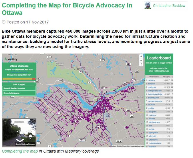
25 Mapillary
26 Step 1: Sidewalk Network in OSM Start with entering sidewalk data into Open Street Maps (OSM) 1. Begin with access to transit locations 2. Prioritize where to begin: not to overlap what other agencies are doing suggest high capacity transit and ferries to start 3. Decide on the method: sidewalks as metadata to roads vs. sidewalks mapped as ways 4. Identify process (bulk import or manual coding) 5. Define essential tags that are needed for step 1 6. Get started
27 Choosing a Methodology Pilot study: Choose handful of existing or future transit hubs for pilot (places where there is added benefit without overlapping efforts) Test various methods (within ½ mile transit shed) and report on time and benefits of each : Manual coding of sidewalks as metadata Manual coding of sidewalks as ways Import sidewalks as ways Sidewalks, crossings
28 Step 2: Consistency for other attributes Identify what other attributes are important to collect Condition, accessibility, width, slope, etc. For what purpose access routing, maintenance costs, other local needs Work with BPAC and OSM Community on consistency of attributes OSM is a global community where some consistency (standards) have been set, some can be proposed Communicating the proposed framework
29 A potential menu approach Menu approach as guidance for local jurisdictions (example): recommend data points x, y and z are collected provide some networking approaches that can be integrated into regional data sets or OSM (example: ArcGIS for local governments) contribution of data collection into Open Street Maps Suggested process (sidewalks as metadata or ways) Suggested tagging of attributes

30 Kim Scrivner, PSRC Kim Scrivner
BPAC Pedestrian and Bicycle Data Collection and Consistency. April 9, 2018
 BPAC Pedestrian and Bicycle Data Collection and Consistency April 9, 2018 The Goal Data Collection and Consistency Obtain regionally consistent bike and pedestrian asset data that supports: potential model
Bicycle / Pedestrian Advisory Committee
 Bicycle / Pedestrian Advisory Committee May 8, 2018 10:00 a.m. 12 Noon PSRC Board Room 1011 Western Avenue, Suite 500 Seattle, WA 98104 10:00 1. Welcome and Introductions 10:10 2. Public Comments, Approve
WALKNBIKE DRAFT PLAN NASHVILLE, TENNESSEE EXECUTIVE SUMMARY NASHVILLE, TENNESSEE
 NASHVILLE, TENNESSEE EXECUTIVE SUMMARY Executive Summary A world-class multi-modal transportation system is essential to a vibrant city and better quality of life. -Mayor Barry The WalknBike plan aims
ADOT Statewide Bicycle and Pedestrian Program Summary of Phase IV Activities APPENDIX B PEDESTRIAN DEMAND INDEX
 ADOT Statewide Bicycle and Pedestrian Program Summary of Activities APPENDIX B PEDESTRIAN DEMAND INDEX May 24, 2009 Pedestrian Demand Index for State Highway Facilities Revised: May 29, 2007 Introduction
Chapter 7. Transportation. Transportation Road Network Plan Transit Cyclists Pedestrians Multi-Use and Equestrian Trails
 Chapter 7 Transportation Transportation Road Network Plan Transit Cyclists Pedestrians Multi-Use and Equestrian Trails 7.1 TRANSPORTATION BACKGROUND The District of Maple Ridge faces a number of unique
ENHANCING LIVABILITY IN YOUR COMMUNITY: RECENT DEVELOPMENTS IN COST-EFFECTIVE MULTIMODAL TRIP PLANNERS
 ENHANCING LIVABILITY IN YOUR COMMUNITY: RECENT DEVELOPMENTS IN COST-EFFECTIVE MULTIMODAL TRIP PLANNERS Sean J. Barbeau Edward L. Hillsman Center for Urban Transportation Research @ University of South
BUILDING THE CASE FOR TRAVEL OPTIONS IN WASHING TON COUNTY. Image: Steve Morgan. Image: Steve Morgan
 BUILDING THE CASE FOR TRAVEL OPTIONS IN WASHING TON COUNTY Image: Steve Morgan Image: Steve Morgan Image: TriMet Image: TriMet WHAT ARE TRAVEL OPTIONS PROGRAMS? Travel options programs encourage residents,
First and Last Mile Plan. April 2016
 First and Last Mile Plan April 2016 1 First and Last Mile refers to the portion of a transit trip between a transit stop and one s destination, and can include walking, biking, carpooling, rolling or driving,
Living Streets Policy
 Living Streets Policy Introduction Living streets balance the needs of motorists, bicyclists, pedestrians and transit riders in ways that promote safety and convenience, enhance community identity, create
TULSA CITY COUNCIL CAPITAL IMPROVEMENT PROGRAM TASK FORCE MEETING JANUARY
 CITY OF TULSA BICYCLE & PEDESTRIAN INFRASTRUCTURE TULSA CITY COUNCIL CAPITAL IMPROVEMENT PROGRAM TASK FORCE MEETING JANUARY 31, 2013 CITY OF TULSA ENGINEERING SERVICES DEPARTMENT CITY OF TULSA ADA TRANSITION
Basalt Creek Transportation Refinement Plan Recommendations
 Basalt Creek Transportation Refinement Plan Recommendations Introduction The Basalt Creek transportation planning effort analyzed future transportation conditions and evaluated alternative strategies for
Hennepin County Bicycle and Pedestrian Planning
 Hennepin County Bicycle and Pedestrian Planning 1 Value of bicycle and sidewalk systems Safety Livability Mobility Health Personal Finances Economic Sustainability Clean Air Recreation Parking and congestion
Bicycle and Pedestrian Chapter TPP Update Overview. TAB September 20, 2017
 Bicycle and Pedestrian Chapter TPP Update Overview TAB September 20, 2017 Bicycling & Walking in the Twin Cities Where are we now? The Bike-Pedestrian system Current trends New developments Where are we
In station areas, new pedestrian links can increase network connectivity and provide direct access to stations.
 The Last Mile Planning for Pedestrians Planning around stations will put pedestrians first. Making walking to stations safe and easy is important; walking will be a part of every rapid transit Accessible
PEDESTRIAN ACTION PLAN
 ATTACHMENT 2 CITY OF SANTA MONICA PEDESTRIAN ACTION PLAN CITY OF SANTA MONICA PEDESTRIAN ACTION PLAN This page intentionally left blank EXECUTIVE SUMMARY CHAPTER 1 EXECUTIVE SUMMARY Setting the Stage
Governor s Transportation Vision Panel
 Office of Governor Kate Brown Governor s Transportation Vision Panel JLA Public Involvement Project Overview The is a yearlong effort to develop a series of recommendations for the Governor that address
SANTA CLARA COUNTYWIDE BICYCLE PLAN August 2008
 SANTA CLARA COUNTYWIDE BICYCLE PLAN August 2008 To assist VTA and Member Agencies in the planning, development and programming of bicycle improvements in Santa Clara County. Vision Statement To establish,
Bicycle Master Plan Goals, Strategies, and Policies
 Bicycle Master Plan Goals, Strategies, and Policies Mobilizing 5 This chapter outlines the overarching goals, action statements, and action items Long Beach will take in order to achieve its vision of
City of Jacksonville Mobility Fee Update
 City of Jacksonville Mobility Fee Update 2017 Preliminary Analysis May 3, 2017 Carnival Cruise lines photo credit Presentation Overview Public Outreach Process Pedestrian and Bicycle Master Plan Study
Bicycling & Walking in the Twin Cities TPP Bike/Ped Chapter Overview. Land Use Advisory Committee September 21, 2017
 Bicycling & Walking in the Twin Cities TPP Bike/Ped Chapter Overview Land Use Advisory Committee September 21, 2017 Presentation Outline Current TPP Purpose of bike/ped chapter New developments Bike/Ped
Bicycle and Pedestrian Planning in a Historically Car-Centric Culture: A Focus on Connectivity, Safety, & Accessibility
 Bicycle and Pedestrian Planning in a Historically Car-Centric Culture: A Focus on Connectivity, Safety, & Accessibility Kate Horton and Zylavian Watley Transportation Planners Memphis MPO Date: October
Toward Zero Deaths. Regional SHSP Road Show Meeting. Virginia Strategic Highway Safety Plan. presented by
 Toward Zero Deaths Regional SHSP Road Show Meeting presented by Virginia Strategic Highway Safety Plan December 1, 2016 1 Welcome & Introductions Purpose of the Meeting Objectives & Key Outcomes Agenda»
Pinellas County Safety Initiatives
 Florida Department of TRANSPORTATION Pinellas County Safety Initiatives Whit Blanton, FAICP Pinellas County MPO A Distinctive County A unique geography Multi-jurisdictional Key demographics seniors and
Methodology for Linking Greenways and Trails with Public Transportation in Florida
 Methodology for Linking Greenways and Trails with Public Transportation in Florida Sara Hendricks, Senior Research Associate Center for Urban Transportation Research, University of South Florida CUTR Webcast,
ACTIVE TRANSPORTATION
 ACTIVE TRANSPORTATION Mobility 2040 Supported Goals Improve the availability of transportation options for people and goods. Support travel efficiency measures and system enhancements targeted at congestion
Active Transportation Connections to Transit
 Active Transportation Connections to Transit Oregon Public Transportation Conference October 20, 2014 Jeff Owen Active Transportation Planner Planning & Policy owenj@trimet.org 503-962-5854 Agency Overview
FINAL PLAN APPENDIX D CITY OF BERKELEY BIKE PLAN D-1
 CITY OF BERKELEY BIKE PLAN D-1 . Proposed Programs D.1. EDUCATION This appendix presents the recommended bicycle-related programs for the City of Berkeley. The recommendations are organized in four E s:
Goals, Objectives, and Policies
 Goals, Objectives, and Policies ADVISORY GROUP INPUT PUBLIC INPUT SNS PREVIOUS STUDIES RBPP Goals Vision Statement Southern Nevada will develop a safe, connected, and convenient walking and bicycling system
Pedestrian, Bicycle and Traffic Calming Strategic Implementation Plan. January 18, 2011
 Pedestrian, Bicycle and Traffic Calming Strategic Implementation Plan January 18, 2011 Tonight s Agenda Receive update on project Provide feedback on two policy issues Complete Streets Policy Project Prioritization
Technical Working Group November 15, 2017
 Technical Working Group November 15, 2017 Welcome and Introductions Project Partners Regional Transportation District (RTD) Colorado Department of Transportation (CDOT) Denver Regional Council of Governments
Chapter VISION, MISSION, AND GOALS AND OBJECTIVES. Vision. Mission. Goals and Objectives CONNECTING COMMUNITIES ACROSS THE ST.
 VISION, MISSION, AND GOALS AND OBJECTIVES Chapter 3 The Plan s vision, mission, and goals and objectives were developed through a series of interactive exercises with the Citizens Advisory Committee (CAC)
First Mile, Last Mile: Plans for all Shapes and Sizes. Hannah Lindelof, Principal Planner San Francisco Bay Area Rapid Transit September 18, 2017
 First Mile, Last Mile: Plans for all Shapes and Sizes Hannah Lindelof, Principal Planner San Francisco Bay Area Rapid Transit September 18, 2017 BART Station Access Policy Goals A. Safer, Healthier, Greener.
Relationship of Road Lane Width to Safety for Urban and Suburban Arterials
 Relationship of Road Lane Width to Safety for Urban and Suburban Arterials Phd. Alma AFEZOLLI Polytechnic University of Tirana Construction and Infrastructure Department of Civil Engineering Faculty Tirana,
Rochester Downtown Bicycle Study 2009
 Rochester Downtown Bicycle Study 2009 Relationship of ROCOG Long Range Transportation Plan to Rochester Comprehensive Plan Regional Long Range Transportation Plan (LRTP) is prepared under the auspices
MASTER BICYCLE AND PEDESTRIAN PLAN
 VILLAGE OF NORTHBROOK MASTER BICYCLE AND PEDESTRIAN PLAN DRAFT PLAN OPEN HOUSE May 2, 2018 AGENDA 1. Community Engagement 2. Vision and Goals 3. General Structure of Plan 4. Recommendations Overview 5.
MassDOT s Transportation Choice and Healthy Transportation Policy Initiatives
 MassDOT s Transportation Choice and Healthy Transportation Policy Initiatives Jackie DeWolfe, Director of Sustainable Mobility, MassDOT Michelle Danila, Complete Streets Engineer, MassDOT ACEC April 2018
CITY OF ELKO BICYCLE AND PATHWAY PLAN
 CITY OF ELKO BICYCLE AND PATHWAY PLAN INTRODUCTION: The City of Elko is intended to provide the basic framework for the development of a functional bicycle and pathway system for the community with connections
AGENDA. Stakeholder Workshop
 AGENDA Stakeholder Workshop 19 th February DLF City Club, Gurgaon IBI GROUP Defining the cities of tomorrow 1 WORKSHOP AGENDA IBI GROUP Defining the cities of tomorrow 2 INTRODUCTION TO THE PBS GUIDANCE
2014 Bellingham Bicycle Master Plan
 2014 Bellingham Bicycle Master Plan Acknowledgements The City of Bellingham is honored by the commitment of the numerous community members and bicycling enthusiasts who participated in the development
CITY MANUALS AND STANDARDS REVIEW
 GEORGETOWN SIDEWALK MASTER PLAN CITY MANUALS AND STANDARDS REVIEW RESOURCES AND STANDARDS As part of the Master Plan process, a review and evaluation of current City documents and policies relevant to
Bicycle Lanes Planning, Design, Funding South Mountain Partnership Trails Workshop Roy Gothie PennDOT Statewide Bicycle Pedestrian Coordinator
 Bicycle Lanes Planning, Design, Funding 2018 South Mountain Partnership Trails Workshop Roy Gothie PennDOT Statewide Bicycle Pedestrian Coordinator Policy Changes: BOP Bicycle Policy Changes The OLD Way
Bicycle and Pedestrian Connectivity Study Phase 2
 Connectivity Study Phase 2 Process PROCESS OUTCOMES Phase Prepared By STEP I Public Participation and Outreach 1. RTP Outreach activities, and development of the Bike and Ped Task Force Phase 1 2011 OCPC
AMATS Complete Streets Policy
 AMATS Complete Streets Policy Table of Contents: Section 1. Definition of Complete Streets Section 2. Principles of Complete Streets Section 3. Complete Streets Policy Section 4. Consistency Section 5.
Pedestrian Project List and Prioritization
 To: Kyle Wagenschutz, City of Memphis CC: From: Anne Conlon and John Cock, Alta Planning + Design Date: December, 2014 Re: Project List Development (Task 3.1-3.2) and Project List Prioritization (Task
Regional Bicycle System Master Study. Preliminary Results Update
 Regional Bicycle System Master Study Preliminary Results Update Transportation Committee October 21, 2013 Introduction Study Goals Guiding Principles Bicycle Study System Elements Analysis Approach Proposed
2. Vision & Goals. Vision. Santa Rosa is a community where walking and bicycling are comfortable and convenient for people of all ages and abilities.
 2. Vision & Goals Overview The goals of the Santa Rosa Bicycle and Pedestrian Master Plan Update reflect the priorities expressed by the community throughout the public outreach phase of this Plan Update.
Working Group Meeting
 Working Group Meeting February 6, 2018 Parks and Natural Resources Operations Building Transportation Analysis Draft Policy Framework Agenda 7:05 pm Welcome 7:10 pm Follow-up from Previous Meetings Schedule
Public Bicycle Sharing Scheme
 National Workshop on Public Bicycle Sharing Scheme 4 th March IBI GROUP Defining the cities of tomorrow 1 PBS GUIDANCE DOCUMENT A STEP-BY-STEP HANDBOOK PBS GUIDANCE DOCUMENT TABLE OF CONTENTS PBS GUIDANCE
Closing Plenary Session
 TRAFFIC SAFETY CONFERENCE Closing Plenary Session June 9, 2017 Las Colinas, TX Order of Report Out June 9, 2017 Las Colinas, TX Distracted Driving Prioritized Countermeasures Countermeasure 4a Systemically
May 12, 2016 Metro Potential Ballot Measure Issue Brief: Local Return
 Summary: Local return is an important revenue source for cities to maintain their local transportation infrastructure. Most cities use their local return to operate small bus systems and repave streets,
Public Transportation and Bicycle & Pedestrian Stakeholder Webinar. April 11, :30 PM
 Public Transportation and Bicycle & Pedestrian Stakeholder Webinar April 11, 2013 1:30 PM Public Transportation and Bicycle & Pedestrian Webinar April 11, 2013 1:30 PM MULTIMODAL TRANSPORTATION PLAN Vision,
Best Southwest Transportation Committee. North Central Texas Council of Governments Transportation Department
 Best Southwest Transportation Committee North Central Texas Council of Governments Transportation Department The The Regional Regional Veloweb Veloweb Review Review NCTCOG Bicycle and Pedestrian Program
A New Approach in the GIS Bikeshed Analysis Considering of Topography, Street Connectivity, and Energy Consumption
 A New Approach in the GIS Bikeshed Analysis Considering of Topography, Street Connectivity, and Energy Consumption ACSP Conference, Cincinnati, OH November 1, 2012 Hiroyuki Iseki, Ph.D. & Matthew Tingstrom
CHAPTER 1 INTRODUCTION
 CHAPTER 1 INTRODUCTION Chapter Table of Contents THE 2017 HOUSTON BIKE PLAN 1-1 HOUSTON BIKEWAYS PROGRAM 1-2 HISTORY OF BICYCLE PLANNING IN HOUSTON 1-3 BICYCLE LEVEL OF COMFORT 1-3 EXISTING PLANS, PROGRAMS
Developing a Bike/Pedestrian Plan Using ArcInfo and Public Participation Rob Shumowsky, Madison County Council of Governments
 Developing a Bike/Pedestrian Plan Using ArcInfo and Public Participation Rob Shumowsky, Madison County Council of Governments Abstract: The Madison County Council of Governments is creating a bike/pedestrian
Perryville TOD and Greenway Plan
 Perryville TOD and Greenway Plan Greenway Glossary Pathway: A bicycle and pedestrian path separated from motorized vehicular traffic by an open space, barrier or curb. Multi-use paths may be within the
August NW Glisan St, Suite 401 Portland, OR (503)
") August 2017 618 NW Glisan St, Suite 401 Portland, OR 97209 (503) 226 0676 www.thestreettrust.org headlines New year, new name, broader mission In January, the Bicycle Transportation Alliance became The
August 2017 618 NW Glisan St, Suite 401 Portland, OR 97209 (503) 226 0676 www.thestreettrust.org headlines New year, new name, broader mission In January, the Bicycle Transportation Alliance became The
Sustainable Transportation Initiatives and Plans in Caledon
 Sustainable Transportation Initiatives and Plans in Caledon Arash Olia, P.Eng., PhD. Coordinator, Transportation Development Finance & Infrastructure Services Town of Caledon Eric Chan, P.Eng., PMP Manager,
Community Task Force November 15, 2017
 Community Task Force November 15, 2017 Welcome and Introductions Project Partners Regional Transportation District (RTD) Colorado Department of Transportation (CDOT) Denver Regional Council of Governments
C C C
 C-012-001 Thank you for your support for the creation of new public space and nonmotorized access between downtown and the waterfront through the Overlook Walk, the East-West Connections, and the Promenade.
Regional Bicycle Barriers Study
 Regional Bicycle Barriers Study Executive Summary Background and Purpose The 2040 Transportation Policy Plan (TPP) sets policies for planning and investment direction in the transportation system in the
Priority 1: Ala Wai Pedestrian and Bicycle Safety and Mobility Project
 Priority 1: Ala Wai Pedestrian and Bicycle Safety and Mobility Project The full application can be found here: http://www.oahumpo.org/wp-content/uploads/2015/05/alawai_application.pdf Description The Ala
DRAFT. Table of Contents. Background
 Douglas County Table of Contents Existing Infrastructure 86 Funding 89 Policy and Program Recommendations 90 Infrastructure Recommendations 92 Conclusion 95 Background Home to 4,500 residents and Baker
PennDOT Bicycle and Pedestrian Initiatives. Jonathan Heilman Roy Gothie Angela Watson
 PennDOT Bicycle and Pedestrian Initiatives Jonathan Heilman Roy Gothie Angela Watson Bicycle and Pedestrian Policy Study Policy Study Purpose Strengthen existing bike ped policy Recognize limited funding
CONTRA COSTA. Countywide Bicycle and Pedestrian Plan. Executive Summary. July Contra Costa Countywide Bicycle & Pedestrian Plan
 CONTRA COSTA Countywide Bicycle and Pedestrian Plan Executive Summary July 2018 i The preparation of this report has been financed through a grant from the U.S. Department of Transportation and the Federal
The City of Chicago s. Bike 2015 Plan. Nick Jackson, Deputy Director Chicagoland Bicycle Federation RAIL-VOLUTION 2006
 The City of Chicago s Bike 2015 Plan Nick Jackson, Deputy Director Chicagoland Bicycle Federation RAIL-VOLUTION 2006 Plan funded by $75,000 grant from the Unified Work Program (UWP) received from the Chicago
Multimodal Analysis in the 2010 Highway Capacity Manual
 Multimodal Analysis in the 2010 Highway Capacity Manual It s not just cars anymore! Jamie Parks, AICP HCAT Conference May 9-10, 2011 Multimodal LOS in the 2010 HCM History and background Overview of methods
10.0 CURB EXTENSIONS GUIDELINE
 10.0 CURB EXTENSIONS GUIDELINE Road Engineering Design Guidelines Version 1.0 March 2017 City of Toronto, Transportation Services City of Toronto Page 0 Background In early 2014, Transportation Services
CHAPTER 7.0 IMPLEMENTATION
 CHAPTER 7.0 IMPLEMENTATION Achieving the vision of the Better Streets Plan will rely on the ability to effectively fund, build and maintain improvements, and to sustain improvements over time. CHAPTER
GIS Based Data Collection / Network Planning On a City Scale. Healthy Communities Active Transportation Workshop, Cleveland, Ohio May 10, 2011
 The Purpose of GIS Based Network Planning GIS Based Data Collection / Network Planning Healthy Communities Active Transportation Conference Tuesday, May 10, 2011 10:00 AM Norman Cox, LLA, ASLA. Ann Arbor,
TOWN OF PORTLAND, CONNECTICUT COMPLETE STREETS POLICY
 TOWN OF PORTLAND, CONNECTICUT COMPLETE STREETS POLICY I. VISION, GOALS & PRINCIPLES VISION To improve the streets of Portland making them safer and more accessible for all users including pedestrians,
Beach Cities Living Streets Design Manual and Aviation Boulevard Multimodal Corridor Plan
 Beach Cities Living Streets Design Manual and Aviation Boulevard Multimodal Corridor Plan AGENDA 1 Introductions & Project Scope 2 Public Outreach Recap 3 Living Streets Design Manual 4 Aviation Boulevard
EXECUTIVE SUMMARY November 2016
 EXECUTIVE SUMMARY November 2016 Purpose The New Jersey Bicycle and Pedestrian Master Plan presents a vision, goals, and strategies to achieve a transportation system in which walking and bicycling are
The Florida Bicycle and Pedestrian Partnership Council
 The Florida Bicycle and Pedestrian Partnership Council Input to the Update of the Florida Transportation Plan March 2015 This document presents input from the Florida Bicycle and Pedestrian Advisory Council
State Bicycle and Pedestrian Advisory Committee Meeting Spring Meeting. April 22nd, 2015 John Bolecek Statewide Bicycle and Pedestrian Planner
 State Bicycle and Pedestrian Advisory Committee Meeting Spring Meeting April 22nd, 2015 John Bolecek Statewide Bicycle and Pedestrian Planner April 2015 BPAC Meeting Overview Agenda 1. Welcome and Introductions
Draft. Lecompton. Table of Contents. Background
 Lecompton Table of Contents Existing Infrastructure 80 Funding 82 Policy and Program Recommendations 83 Infrastructure Implementation Scenarios 84 Conclusion 85 Douglas County Lecompton Background Located
City Snapshot September 27, 2018
 1 City Snapshot September 27, 2018 Respondent Introduction Thank you for providing data for the PlacesForBikes City Rating program! The information you provide will be used to understand the progress your
10/18/2017. Today s webinar agenda. Continuing Education. Designing Transit to Support Active Transportation, and Vice Versa
 Today s webinar agenda 3:00 pm: Introduction 3:05 pm: Presentation 3:45 pm: Questions 4:00 pm: Webinar ends For technical assistance during the webinar: 1 800 263 6317 Choose these prompts: 1,1,1 Continuing
Chapter 2. Bellingham Bicycle Master Plan Chapter 2: Policies and Actions
 Chapter 2 Bellingham Bicycle Master Plan Chapter 2: Policies and Actions Chapter 2: Policies and Actions The Bicycle Master Plan provides a road map for making bicycling in Bellingham a viable transportation
Appendix C. Corridor Spacing Research
 Appendix C. Corridor Spacing Research Task 3 of the Twin Cities Bicycle Study called for the development of bicycle corridor spacing guidelines. This section summarizes research of the spacing of planned
Building Community Partnerships for Mobility:
 Building Community Partnerships for Mobility: San Francisco 2008 Presented by: Cynthia Hoyle, AICP Transportation Planning Consultant Champaign-Urbana Mass Transit District Background The Heartland Champaign-Urbana,
San Francisco Streetscape Prioritization. Best Practices Review. November 2014
 November 2014 29 Table of Contents Executive Summary... ES-1 Introduction... 1 Case Study Prioritization Methodologies... 1 Charlotte Sidewalk Retrofit Program... 1 Portland Safe Routes to School... 2
Bicycle and Pedestrian Advisory Committee Agenda
 Bicycle and Pedestrian Advisory Committee Agenda Date: Tuesday, January 8, 2019 from 10:00 a.m.-12:00 p.m. Location: PSRC Board Room, 1011 Western Avenue, Suite 500, Seattle, WA 98104 1. Welcome and Introductions
OTO BIKE/PED PLAN REPORT
 OTO BIKE/PED PLAN REPORT 6/30/2011 Implementation in FY2011 This report outlines the bike/ped accomplishments related to the OTO Bike/Ped Plan. Activities occurring during the 2011 Fiscal Year, July 1,
Access BART: TOD and Improved Connections. October 29, 2008
 Access BART: TOD and Improved Connections October 29, 2008 1 Access BART Study Goals Evaluate at the system-level land use and access scenarios to optimize ridership Identify station clusters that provide
 Time of Change We Are Growing We Are An Attractive Place To Live We Are Age Diverse + Living Longer 50000 40000 30000 20000 10000 0 2010 Census Job Density Housing Sheds Transit Sheds The Project FUNDING
Environment and Public Works Committee Presentation
 Mixed Use Centers Complete Streets Guidelines Project Environment and Public Works Committee Presentation December 10, 2008 Project Objectives: Conduct an inter-departmental and agency process to study
CITY OF COCOA BEACH 2025 COMPREHENSIVE PLAN. Section VIII Mobility Element Goals, Objectives, and Policies
 CITY OF COCOA BEACH 2025 COMPREHENSIVE PLAN Section VIII Mobility Element Goals, Objectives, and Policies Adopted August 6, 2015 by Ordinance No. 1591 VIII MOBILITY ELEMENT Table of Contents Page Number
AMERICANS WITH DISABILITIES ACT TRANSITION PLAN LEON COUNTY FOR CURB RAMPS AND SIDEWALKS DEPARTMENT OF PUBLIC WORKS. 1 P age
 AMERICANS WITH DISABILITIES ACT TRANSITION PLAN FOR CURB RAMPS AND SIDEWALKS 2015 LEON COUNTY DEPARTMENT OF PUBLIC WORKS 1 P age INTRODUCTION The goal of the Americans with Disabilities Act (ADA) Transition
York Region Population and Employment Growth
 March 1, 2016 1 York Region Population and Employment Growth York Region needs to comply with The Provincial Growth Plan and new forecasts introduced to 2036 and 2041 2 Regional Official Plan Review York
Beyond First First Last Last Mile Strategies. APA National Conference April 3, 2016 Chelsea Richer, AICP Fehr & Peers
 Beyond First First Last Last Mile Strategies APA National Conference April 3, 2016 Chelsea Richer, AICP Fehr & Peers 1 Beyond First Last Mile Strategies APA National Conference Jeremy Klop, AICP, Fehr
Community Transportation Plan Acknowledgements
 Community Transportation Plan Acknowledgements The Decatur CTP was developed with participation and guidance from City of Decatur staff, its Resident Boards and Commissions, and numerous residents, business
MONTGOMERY COUNTY PLANNING DEPARTMENT THE MARYLAND-NATIONAL CAPITAL PARK AND PLANNING COMMISSION
 MONTGOMERY COUNTY PLANNING DEPARTMENT THE MARYLAND-NATIONAL CAPITAL PARK AND PLANNING COMMISSION MCPB Item No. 4 Date: 09-10-15 Scope of Work for the Bicycle Master Plan David Anspacher, Planner/Coordinator,
NACTO Designing Cities 2016 Seattle September 26 29
 NACTO Designing Cities 2016 Seattle September 26 29 nacto.org/conference Now in its fifth year, the NACTO Designing Cities conference is the nation's premier gathering of transportation leaders and practitioners
Major Bike Routes 102 Avenue Workshop April 21, 2015
 Major Bike Routes 102 Avenue Workshop April 21, 2015 Our Purpose Today Provide context on how Major Bike Routes fit into Edmonton s future Share information on what we heard in our last phase, and how
Measuring and Communicating Mobility:
 Measuring and Communicating Mobility: The District Mobility Project Stephanie Dock, District Department of Transportation TRB Transportation Issues in Major Cities Committee May 2, 2017 Deconstructing
2040 RTP. Chapter 6: Investments in our Transportation Future
 2040 RTP Chapter 6: Investments in our Transportation Future This chapter describes the transportation investments proposed for the San Benito region that support the goals and objectives of the Regional
CTDOT Pedestrian and Bicycle Safety Initiatives
 CTDOT Pedestrian and Bicycle Safety Initiatives 2017 Northeast Transportation Safety Conference Mark F. Carlino, P.E. Traffic Engineering Division Chief Bureau of Engineering and Construction Connecticut
Multimodal Level of Service in King County
 Multimodal Level of Service in King County A Guide to Incorporating Alternative Modes of Transportation into Local Jurisdictions Roadway Performance Measurements Made possible by funding from the Department
PROJECT BACKGROUND/DESCRIPTION
 SCOPE OF SERVICES St. Charles Parish Comprehensive Pedestrian and Bicycle Master Plan (CPBP) St. Charles Parish, Louisiana State Project No. H. 012462 RPC Project No. SCPBMP1 PROJECT BACKGROUND/DESCRIPTION