Active Transportation Connections to Transit
|
|
|
- Tamsin Fisher
- 5 years ago
- Views:
Transcription
1 Active Transportation Connections to Transit Oregon Public Transportation Conference October 20, 2014 Jeff Owen Active Transportation Planner Planning & Policy

2 Agency Overview Located in Portland metropolitan region Service area of 532 square miles Population of 1.5 million 52 mile MAX light rail track 79 bus lines 12 frequent service 14.7 mile WES Commuter Rail 100 million trips on TriMet each year Most riders (78%) are choice riders
3 Transit + Active Transportation 1. Transit + AT = Natural complements to each other 2. Active transportation excels at short trips and connections to transit 3. Biking and walking are not competitors to transit; We are all is this together
4 Active Transportation Program trimet.org/walk trimet.org/bike

5

6

7 PMLR Snapshot

8

9

10


11 Portland-Milwaukie Project Bike/Ped Fact Sheet - Bike and Ped Access
12 Active Transportation Program trimet.org/walk trimet.org/bike

13 Lack of infrastructure has a direct effect on LIFT services =
14


15


16

17

18

19

20

21

22


23 Bus Stop Environment Functional Higher quality & safer


24 Sidewalk Corridors Functional Higher quality & safer

25 Walking Audits Watch what people do Document conditions

26

27 Pedestrian Network Analysis Overview: We need safer and more comfortable access to transit This effort helps us to identify areas where access improvements have the greatest need and the biggest opportunities Provides focus amidst great need throughout the region Available for download at: trimet.org/walk

28 Over 6,500 transit stops total
29 Pedestrian Network Analysis Overview of Process: Big service area with lots of transit stops 1. Base Analysis (land use, ridership, destinations) 2. Overlay Analysis (deficiencies and opportunities) 3. Composite Scores (look for clusters, then focus areas)

30 Pedestrian Network Analysis

31

32 Pedestrian Network Analysis Partners are KEY to this process Ongoing Efforts: Initial effort complete, but we are still working hard to find funding for projects around the region Also working to refine this analysis and develop a complementary corridor specific tool


33 Hwy 8/SW Oaks Street at Winco Hillsboro, stop id 4119, line 57 Before After


34 185 th at TV Hwy Aloha stop id 7012, line 52 Before After

35

36

37

38

39

40


41 Partnership Highlight RRFB partnership between TriMet and City of Portland: 60th/I-84/Max Station install July 2012 SE Stark/126th install Fall 2012 SE Division/I-205 install February 2013 SW Beaverton-Hillsdale Highway/62nd install January 2013
42 Funding Opportunities Such as... Source Lead Project types Amount STIP Enhance TriMet/Cities (includes Portland, Gresham, Tigard, Washington County, ODOT) 3 Corridors: Sidewalks, safe crossings, rapid flash beacons, medians, signalized intersections, bus stop improvements $8.0 million MTIP REOF TriMet & City of Portland 1 Corridor: Sidewalks, safe crossings, rapid flash beacons, medians, signalized intersections, bus stop improvements, bike access MTIP RFFA Cities and Counties 10 projects with direct benefits for transit riders = sidewalks, safe crossings, streetscape, bus stop improvements, bike access TOTAL PENDING: $9.1 million $32.1 million $48.5 million
43 Are We Finished? No. Our work continues There is much more to do Partnerships are key Analyze and Set priorities

44 What Can You Do? Walking Audits Day/Night Observations Collect Data Plan and Apply for Funding Talk to your co-workers, friends, family Support active transportation and connections to transit

45 trimet.org/walk Jeff Owen Active Transportation Planner Planning & Policy


46 Active Transportation Program trimet.org/walk trimet.org/bike
47 Bike on Bus, 2 per rack, all buses (600 buses = 1200 spaces) Bike racks at most rail stations and some bus stops (371 spaces) Reserved, keyed bike lockers (436 spaces) On-demand, electronic lockers (32) Group parking facilities (3 structures = 180)


48 Bikes onboard front of Bus All buses in the system, 2 per rack


49 Folding Bikes onboard inside Allowed system wide, like luggage Photos provided by Will Vanlue


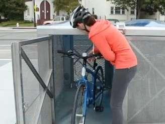
50 Bikes onboard MAX and WES Allowed system wide - if there is room
 = up to")


51 Bikes onboard MAX and WES MAX: Low + Low: 8 bikes on hooks, plus any additional in priority areas (up to 8 more) = up to 16 total MAX: High + Low: 4 bikes on hooks, 5 or 6 in high floor spots, plus any additional in priority areas (up to 4 more) = up to 14 total WES: Double Car: 4 on hooks, up to 8 more in priority secured areas = up to 12 total More at: trimet.org/bikes


52 Open Bike Racks Almost all rail stations, some bus stops


53 Keyed Bike Lockers $25 per 6 months, reserved


54 Electronic Bike Lockers On-demand, 5 cents per hour


55 Bike & Ride Group Parking Facilities Secure and enclosed
56 Bikes: What are we doing now? 1. Just awarded a state funded TGM Grant for creation of a TriMet Bicycle Plan. Expected July 15 June 16. Project Summary: The TriMet Bicycle Plan would result in a final document providing guidance to agency policy and planning efforts regarding bicycle accommodation on-board transit vehicles; appropriate bicycle parking types and quantities at stations and stops; and innovative marketing strategies to ensure usage and acceptance. Process would include public involvement, jurisdictional coordination, and private sector partner outreach. More at:
57 Gresham MAX Path More at
58 Bikes: What are we doing now? 2. Policy: Preserve access for bikes onboard and parking 3. Maintenance: Take care, make small improvements 4. Strategic Investments: a) FTA Transit Enhancements: Improvements at up to 20 stations 5. New Large Group Facilities: a) Developer/City/State Grant: Orenco b) ConnectOregon V: Goose Hollow and Beaverton Creek c) PMLR Rail Project: Tacoma and Park Ave. elockers at Milwaukie, and lots of covered parking no new keyed lockers d) East Portland Active Transportation to Transit: Gateway TC


59 New: Orenco/NW 231 st Ave Partnership with City of Hillsboro and developer, plus Metro/State grant


60 New: COV: Goose Hollow Future Enhanced Bike Parking Sample Image: Covered Bike Parking on SW Moody, part of PMLR project


61 New: COV: Beaverton Creek Future Enhanced Bike Parking


62 New: PMLR: SE Tacoma St Future Secure Bike & Ride building


63 New: PMLR: SE Park Ave Future Secure Bike & Ride


64 Annual Bike Parking Projects Doubled rack spaces at Beaverton Creek and Millikan Way 4 new elockers installed at Providence Park Similar rack improvements coming soon to: 82 nd, Gateway, 122 nd, Gresham Central, Gresham City Hall, Quatama, Oregon City TC


65 Future: Mobility Hubs? GoPoint Summary: Help create a balanced suburban transportation system by branding, promoting, and managing a network of mobility hubs that use technology to integrate public and private transportation options. Team in New York, presenting idea to Bloomberg Philanthropies. Courtesy of WTA wta-tma.org. (L-R) Brad Choi, Peter Brandom, Aron Carleson, Heather McCarey Screen capture from Hillsboro GoPoint video

 Corporate")

66 Future: Bike Share as First/Last Mile 1. Municipal (ex: Portland Bike Share, pdxbikeshare.com) City/Region wide Large kiosks 2. Corporate (ex: Intel OBI, Nike, Kaiser) Corporate campus to transit In development 3. Emerging (ex: Kiel s approach, other new technology) Flexible, scalable Can start small


67 Future: Corporate Bike Share Intel OBI pilot: Developing an open source-inspired model for bike sharing Pilot project with 30 bikes Plan to re-launch with more bikes after acceptance Great potential for link to MAX (LRT) stations! instagram.com/openbikeinitiative openbikeinitiative.org


68 Future: Corporate Bike Share Nike Bike Share: Building upon Intel model Pilot project with 250 bikes Great potential for linking employees to MAX light rail service on the work end, taking care of the work part of the first/last mile Employee can then use a personal bike or walk/bus on the home part of the first/last mile

69 Future: Corporate Bike Share Kaiser e-bike pilot: Metro RTO grant award to acquire, deploy, and study usage patterns of 30 folding e-bikes to 180 employees at three work sites Test user acceptance of e-bikes as a first/last mile commuting solution Employee would have the bike for up to 3 months Bike model selected for project: Currie izip E3 Compact

70 Spotted at Sunset Bike & Ride: One of Kaiser s folding ebikes...

71 Participants in the study may use the e-bikes however they wish, with the expectation they will be used as a first/last mile commuting solution for longer trips. For example, instead of driving to work, participants could take public transportation such as the MAX Light Rail, using the e-bikes to get from home or work to the transit stop.
72 Active Transportation Connections to Transit Oregon Public Transportation Conference October 20, 2014 Jeff Owen Active Transportation Planner Planning & Policy
Transit on Tap: Bikes and Transit
 Transit on Tap: Bikes and Transit July 29, 2014 Jeff Owen Active Transportation Planner Planning & Policy owenj@trimet.org 503-962-5854 Transit + Active Transportation 1. Transit + AT = Natural complements
Rehabilitating First- and Last- Mile Connections
 Rehabilitating First- and Last- Mile Connections Sept 18, 2017 Rail~ Volution Jeff Owen Senior Planner Active Transportation TriMet, Planning & Policy Portland, Oregon owenj@trimet.org 503-962-5854 Outline
Washington County SW Beaverton-Hillsdale Hwy. & SW Scholls Ferry Rd.
 Washington County SW Beaverton-Hillsdale Hwy. & SW Scholls Ferry Rd. SW Beaverton-Hillsdale Hwy. & SW Scholls Ferry Rd. Washington County The SW Beaverton-Hillsdale Hwy & SW Scholls Ferry Rd. focus area
If a person walks within this focus area, these are examples of the places he or she could walk to or from:
 Portland Hillsdale Hillsdale Portland The Hillsdale focus area is located in the City of Portland. It is situated approximately three miles from the City of Portland s downtown, 5.5 miles from the City
Setting the Standard: An Introduction to Bicycle Accessibility to Transit Agencies
 Setting the Standard: An Introduction to Bicycle Accessibility to Transit Agencies The Question --- How do transit operators optimize the multimodal (transit to bike) user experience? --- Page 2 Setting
Hillsboro Tanasbourne Town Center
 Hillsboro Tanasbourne Town Center Tanasbourne Town Center Hillsboro The Tanasbourne Town Center focus area is located in the City of Hillsboro. It is situated approximately six miles from the City of Hillsboro
Capital and Strategic Planning Committee. Item III - B. April 12, WMATA s Transit-Oriented Development Objectives
 Capital and Strategic Planning Committee Item III - B April 12, 2018 WMATA s Transit-Oriented Development Objectives Page 24 of 76 Washington Metropolitan Area Transit Authority Board Action/Information
BUILDING THE CASE FOR TRAVEL OPTIONS IN WASHING TON COUNTY. Image: Steve Morgan. Image: Steve Morgan
 BUILDING THE CASE FOR TRAVEL OPTIONS IN WASHING TON COUNTY Image: Steve Morgan Image: Steve Morgan Image: TriMet Image: TriMet WHAT ARE TRAVEL OPTIONS PROGRAMS? Travel options programs encourage residents,
Planning Transit Operations and Bike Sharing Denver RTD. Bill Van Meter, Assistant General Manager, Planning March 23, 2012
 Planning Transit Operations and Bike Sharing Denver RTD Bill Van Meter, Assistant General Manager, Planning March 23, 2012 1 Overview RTD Background RTD Bike-n-Ride Program RTD - Bike Share Coordination:
We believe the following comments and suggestions can help the department meet those goals.
 The Honorable Secretary Anthony Foxx The Secretary of Transportation United States Department of Transportation 1200 New Jersey Avenue, SE Washington, DC 20590 August 30, 2013 Dear Secretary Foxx, Thank
Broward Boulevard Gateway Implementation Project, Downtown Walkability Analysis, & Joint Development Initiative (JDI)
") Broward Boulevard Gateway Implementation Project, Downtown Walkability Analysis, & Joint Development Initiative (JDI) City of Fort Lauderdale ~ Commission Conference July 10, 2012 Page 1 of 15 A Multi-Agency
Broward Boulevard Gateway Implementation Project, Downtown Walkability Analysis, & Joint Development Initiative (JDI) City of Fort Lauderdale ~ Commission Conference July 10, 2012 Page 1 of 15 A Multi-Agency
Tigard Tigard Transit Center
 Tigard Tigard Transit Center Tigard Transit Center Tigard The Tigard Transit Center focus area is located in the City of Tigard. It is situated in the City of Tigard s downtown and is 4.5 miles from the
Community Task Force November 15, 2017
 Community Task Force November 15, 2017 Welcome and Introductions Project Partners Regional Transportation District (RTD) Colorado Department of Transportation (CDOT) Denver Regional Council of Governments
First and Last Mile Plan. April 2016
 First and Last Mile Plan April 2016 1 First and Last Mile refers to the portion of a transit trip between a transit stop and one s destination, and can include walking, biking, carpooling, rolling or driving,
Online Open House Survey Report. December 2016
 December 216 I. OVERVIEW & OUTREACH SUMMARY Introduction Washington County evaluated long-term transportation investments and strategies as part of the Transportation Futures Study. The purpose of the
Bus Rapid Transit Plans
 Twin Cities Region Bus Rapid Transit Plans ULI Minnesota Workshop Connecting Bus Rapid Transit to the Community December 15, 2009 John Levin Director of Service Development Metro Transit Metropolitan Area
Bus Rapid Transit ALTERNATIVES ANALYSIS. Open House
 Bus Rapid Transit ALTERNATIVES ANALYSIS Open House June 23, 2015 Open House Meeting Agenda Agenda Introductions What is BRT? Project Goals Study Tasks Next steps Discussion PVTA Bus Rapid Transit Study
CITY OF COCOA BEACH 2025 COMPREHENSIVE PLAN. Section VIII Mobility Element Goals, Objectives, and Policies
 CITY OF COCOA BEACH 2025 COMPREHENSIVE PLAN Section VIII Mobility Element Goals, Objectives, and Policies Adopted August 6, 2015 by Ordinance No. 1591 VIII MOBILITY ELEMENT Table of Contents Page Number
West Village Mobility & Integration
 West Village Mobility & Integration PRESENTED TO TOPCA Town Hall November 9, 2017 [7189-21] Port Credit 2 West Village + Mobility AWalkable Community A CompleteCommunity A SustainableCommunity 3 Mobility
Technical Working Group November 15, 2017
 Technical Working Group November 15, 2017 Welcome and Introductions Project Partners Regional Transportation District (RTD) Colorado Department of Transportation (CDOT) Denver Regional Council of Governments
North Coast Corridor:
 North Coast Corridor: Connecting People, Transportation & Environment Legislative Hearing: 11.8.10 1 North Coast Corridor Region s Lifeline A Regional Strategy Mobility, Economy & Environment North Coast
Toward Zero Deaths. Regional SHSP Road Show Meeting. Virginia Strategic Highway Safety Plan. presented by
 Toward Zero Deaths Regional SHSP Road Show Meeting presented by Virginia Strategic Highway Safety Plan December 1, 2016 1 Welcome & Introductions Purpose of the Meeting Objectives & Key Outcomes Agenda»
Metropolitan Council Transportation Committee
 Nicollet-Central Transit Alternatives Metropolitan Council Transportation Committee August 2013 Project Purpose (approved by Policy Advisory Committee 10/25/2012) The purpose is to improve transit connectivity,
Beyond First First Last Last Mile Strategies. APA National Conference April 3, 2016 Chelsea Richer, AICP Fehr & Peers
 Beyond First First Last Last Mile Strategies APA National Conference April 3, 2016 Chelsea Richer, AICP Fehr & Peers 1 Beyond First Last Mile Strategies APA National Conference Jeremy Klop, AICP, Fehr
4 Ridership Growth Study
 Clause 4 in Report No. 15 of Committee of the Whole was adopted, without amendment, by the Council of The Regional Municipality of York at its meeting held on November 16, 2017. 4 Ridership Growth Study
Swift Bus Rapid Transit. June DeVoll, Community Transit & Tom Hingson, Everett Transit
 Swift Bus Rapid Transit June DeVoll, Community Transit & Tom Hingson, Everett Transit October 22, 2013 Swift Washington State s First BRT is almost 4 years old Everett Transit Everett Transit College Station
TRANSIT & NON-MOTORIZED PLAN DRAFT FINAL REPORT Butte County Association of Governments
 1 INTRODUCTION Maintaining a high quality of life is the essence of this plan for transit and non-motorized transportation in Butte County. Curbing greenhouse gas emissions (GHG) by reducing congestion,
Purpose and Need. For the. Strava Bicycle Data Project
 Purpose and Need For the Strava Bicycle Data Project April 2014 ODOT Strava Workgroup Margi Bradway*, Active Transportation Section Alex Bettenardi*, Transportation Planning Analysis Unit Phil Smith*,
Climate Change Action Plan: Transportation Sector Discussion Paper: Cycling
 Climate Change Action Plan: Transportation Sector Discussion Paper: Cycling ontario.ca/climatechange Contents 1. Minister of Transportation s message... 3 2. Introduction... 5 3. Sector Overview and Support
ALTERNATIVES ANALYSIS EXECUTIVE SUMMARY
 West Valley Connector Corridor ALTERNATIVES ANALYSIS EXECUTIVE SUMMARY FINAL September 2014 Ontario International Airport Ontario Mills Rancho Cucamonga Metrolink Station Kaiser Permanente PARSONS EXECUTIVE
Eliminate on-street parking where it will allow for a dedicated bus only lane %
 Traffic Dashboard Priorities Survey Responses Introduction 1) Are you familiar with bus rapid transit (BRT)? a. No, BRT is new to me. 597 23.5% b. I ve heard of BRT, but I don t know much about it. 1,136
Governor s Transportation Vision Panel
 Office of Governor Kate Brown Governor s Transportation Vision Panel JLA Public Involvement Project Overview The is a yearlong effort to develop a series of recommendations for the Governor that address
Forging Bicycle/Transit Connections at King County Metro. Eileen Kadesh Senior Market Development Planner King County Metro Transit October 2, 2012
 Forging Bicycle/Transit Connections at King County Metro Eileen Kadesh Senior Market Development Planner King County Metro Transit October 2, 2012 Highlights Background Bike program evolution Best practices/metro
Hennepin County Bicycle and Pedestrian Planning
 Hennepin County Bicycle and Pedestrian Planning 1 Value of bicycle and sidewalk systems Safety Livability Mobility Health Personal Finances Economic Sustainability Clean Air Recreation Parking and congestion
Chapter 7. Transportation. Transportation Road Network Plan Transit Cyclists Pedestrians Multi-Use and Equestrian Trails
 Chapter 7 Transportation Transportation Road Network Plan Transit Cyclists Pedestrians Multi-Use and Equestrian Trails 7.1 TRANSPORTATION BACKGROUND The District of Maple Ridge faces a number of unique
Access BART: TOD and Improved Connections. October 29, 2008
 Access BART: TOD and Improved Connections October 29, 2008 1 Access BART Study Goals Evaluate at the system-level land use and access scenarios to optimize ridership Identify station clusters that provide
Welcome. Background. Goals. Vision
 Welcome The formal Public Information Centre (PIC) for the Transportation Master Plan How We GO will be held in early 2017. At that time we will present the recommended transportation system for Niagara
Active Transportation on the Rise
 Integrated Approaches to Shared-Use Paths Doug Sarkkinen, PE Windi Shapley, PE Mandi Roberts, AICP, PLA Why? Biking and walking are important active transportation options. Shared-use paths are critical
Southwest Bus Rapid Transit (SW BRT) Functional Planning Study - Executive Summary January 19 LPT ATTACHMENT 2.
 Functional Planning Study - Executive Summary January 19 LPT ATTACHMENT 2.") Southwest Bus Rapid Transit (SW BRT) Functional Planning Study - Executive Summary 2011 January 19 1 of 19 Introduction This executive summary presents the results of the Southwest Bus Rapid Transit (SW
Southwest Bus Rapid Transit (SW BRT) Functional Planning Study - Executive Summary 2011 January 19 1 of 19 Introduction This executive summary presents the results of the Southwest Bus Rapid Transit (SW
Corridor Vision Workshop Summary James Madison Elementary February 22,2018
 Corridor Vision Workshop Summary James Madison Elementary February 22,2018 WHY DEVELOP THIS STUDY? Ogden City is planning for better connectivity and access to jobs and housing. Working with area partners,
Arterial Transitway Corridors Study. Ave
 Arterial Transitway Corridors Study Ave January 2012 Arterial Transitway Corridors Study Overview Corridor Features and Demographics 11 study corridors, 95 route miles 86,000 daily rides and half of existing
Community Transportation Plan Acknowledgements
 Community Transportation Plan Acknowledgements The Decatur CTP was developed with participation and guidance from City of Decatur staff, its Resident Boards and Commissions, and numerous residents, business
Agenda. Overview PRINCE GEORGE S PLAZA METRO AREA PEDESTRIAN PLAN
 PRINCE GEORGE S PLAZA METRO AREA PEDESTRIAN PLAN May 28, 2008 Agenda Welcome and introductions Project overview and issue identification Planning context and strengths Design challenges and initial recommendations
PURPOSE AND NEED SUMMARY 54% Corridor Need 1. Corridor Need 2. Corridor Need 3. Corridor Need 4. Corridor Need 5
 SUMMARY PURPOSE AND NEED Chapel Hill Transit ridership has increased Buses operate every 4 minutes and have standing room only Exceeding seated capacity by 12% Corridor Need 1 by more than 20 percent between
Bellevue Transportation: Challenges, Opportunities and Priorities Bellevue Downtown Association September 20, 2018
 Bellevue Transportation: Challenges, Opportunities and Priorities Bellevue Downtown Association September 20, 2018 Dave Berg Transportation Director City of Bellevue Traffic, traffic and more traffic!
Highway 217 Corridor Study. Phase I Overview Report
 Highway 217 Corridor Study Phase I Overview Report November 3, 24 BACKGROUND AND OVERVIEW Study purpose The Highway 217 Corridor Study is developing multi-modal transportation solutions for traffic problems
Environment and Public Works Committee Presentation
 Mixed Use Centers Complete Streets Guidelines Project Environment and Public Works Committee Presentation December 10, 2008 Project Objectives: Conduct an inter-departmental and agency process to study
Community Engagement Process
 Community Engagement Process PHASE ONE PURPOSE + NEED STATEMENT IDEAS DESTINATIONS TRAVEL PATTERNS PHASE TWO MODE SELECTION INPUT PHASE THREE LOCALLY PREFERRED ALTERNATIVE SELECTION OF PREFERRED ALTERNATIVE
TAC February 1, 2012 Prepared by Metro Bike Program
 Bike Share Concept Report/Strategy TAC February 1, 2012 Prepared by Metro Bike Program July 2011 Board Directive 1. Requires Metro to take a leadership role in implementing bike share in LA County. 2.
Presentation of Staff Draft March 18, 2013 COUNTYWIDE TRANSIT CORRIDORS FUNCTIONAL MASTER PLAN
 Presentation of Staff Draft March 18, 2013 COUNTYWIDE TRANSIT CORRIDORS FUNCTIONAL MASTER PLAN Public Outreach Fall 2011: Two community meetings/open houses Fall 2012: Three community meetings/open houses
Basalt Creek Transportation Refinement Plan Recommendations
 Basalt Creek Transportation Refinement Plan Recommendations Introduction The Basalt Creek transportation planning effort analyzed future transportation conditions and evaluated alternative strategies for
PEDALING FORWARD. A Glance at the SFMTA s Bike Program for SFMTA.COM
 PEDALING FORWARD A Glance at the SFMTA s Bike Program for 2017-2021 SFMTA.COM INTRODUCTION About This Booklet More people from all walks of life see their bicycle as a more convenient way to get where
Tunnel Reconstruction Brooklyn CB 1 August 14, 2018
 Tunnel Reconstruction Brooklyn CB 1 August 14, 2018 Reconstructing the Tunnel 2 Service During Tunnel Reconstruction April 2019 through July 2020 3 Projected Cross River Travel Paths of Customers The Service
ADOT Statewide Bicycle and Pedestrian Program Summary of Phase IV Activities APPENDIX B PEDESTRIAN DEMAND INDEX
 ADOT Statewide Bicycle and Pedestrian Program Summary of Activities APPENDIX B PEDESTRIAN DEMAND INDEX May 24, 2009 Pedestrian Demand Index for State Highway Facilities Revised: May 29, 2007 Introduction
Tunnel Reconstruction South 5 th Street Association October 16, 2018
 Tunnel Reconstruction South 5 th Street Association October 16, 2018 Reconstructing the Tunnel 2 Service During Tunnel Reconstruction April 2019 through July 2020 3 Projected Cross River Travel Paths of
Best Southwest Transportation Committee. North Central Texas Council of Governments Transportation Department
 Best Southwest Transportation Committee North Central Texas Council of Governments Transportation Department The The Regional Regional Veloweb Veloweb Review Review NCTCOG Bicycle and Pedestrian Program
» Draft Recommendations» Discussion» Next Steps. Plan for Walking and Biking
 SAC Meeting Plan #3 for September Walking and 12, Biking 2018 » Draft Recommendations» Discussion» Next Steps Plan for Walking and Biking » Stakeholder and Public Outreach» Background data collection and
SUMMARY OF TRANSPORTATION INVESTMENTS
 Santa Cruz County 2016 Measure D: Transportation Improvement Expenditure Plan - Approved by over 2/3 of Santa Cruz County voters on November 8, 2016 - Overview Measure D, the 2016 Transportation Improvement
WALKNBIKE DRAFT PLAN NASHVILLE, TENNESSEE EXECUTIVE SUMMARY NASHVILLE, TENNESSEE
 NASHVILLE, TENNESSEE EXECUTIVE SUMMARY Executive Summary A world-class multi-modal transportation system is essential to a vibrant city and better quality of life. -Mayor Barry The WalknBike plan aims
METRO RTA TRANSIT MASTER PLAN. May 25-26, 2011
 METRO RTA TRANSIT MASTER PLAN May 25-26, 2011 WHAT IS THE TRANSIT MASTER PLAN? A twenty-year plan for METRO RTA What will METRO look like in 2031? 1 TRANSIT TECHNOLOGIES 2 TRANSIT TECHNOLOGIES Transit
San Francisco s Capital Plan & the Mayor s Transportation Task Force 2030: Funding the next steps for transportation
 San Francisco s Capital Plan & the Mayor s Transportation Task Force 2030: Funding the next steps for transportation San Francisco Capital Needs In 2006, the Mayor and Board of Supervisors approved San
SMART 1 Public Meeting #1. February 24, 2016
 SMART 1 Public Meeting #1 February 24, 2016 Agenda Who is the SMTC? SMART 1 project overview Syracuse Metropolitan Transportation Council An Introduction: Who we are & what we do What is an MPO? A Metropolitan
Washington Metropolitan Area Transit Authority Board Action/Information Summary. MEAD Number:
 Washington Metropolitan Area Transit Authority Board Action/Information Summary Action Information MEAD Number: 100962 Resolution: Yes No TITLE: Bicycle and Pedestrian Access Improvements Study PURPOSE:
JOINT PARTNERSHIPS: Working Together To Support Light Rail in Santa Monica
 JOINT PARTNERSHIPS: Working Together To Support Light Rail in Santa Monica ITY OF ANTA MONICA RAIL-VOLUTION / OCTOBER 17, 2012 SARAH LEJEUNE, PRINCIPAL PLANNER, STRATEGIC + TRANSPORTATION PLANNING DIVISION
Bicycle Master Plan Goals, Strategies, and Policies
 Bicycle Master Plan Goals, Strategies, and Policies Mobilizing 5 This chapter outlines the overarching goals, action statements, and action items Long Beach will take in order to achieve its vision of
MONTGOMERY COUNTY PLANNING DEPARTMENT THE MARYLAND-NATIONAL CAPITAL PARK AND PLANNING COMMISSION
 MONTGOMERY COUNTY PLANNING DEPARTMENT THE MARYLAND-NATIONAL CAPITAL PARK AND PLANNING COMMISSION MCPB Item No. 4 Date: 09-10-15 Scope of Work for the Bicycle Master Plan David Anspacher, Planner/Coordinator,
Community Task Force July 25, 2017
 Community Task Force July 25, 2017 Welcome and Introductions Project Partners Regional Transportation District (RTD) Colorado Department of Transportation (CDOT) Denver Regional Council of Governments
Appendix C 3. Bicycle / Pedestrian Planning
 Appendix C 3. Bicycle / Pedestrian Planning BICYCLE/PEDESTRIAN PLANNING 2005 Master Plan GOAL: Provide for safe and convenient bicycle and pedestrian circulation throughout the City. Develop a city-wide
Bicycle Network Planning Report
 King County Bicycle Network Planning Report November 2017 What is the Bicycle Network Planning Report? 2016 King County Comprehensive Plan action item #11 Evaluation of existing King County bicycle planning
Omaha s Complete Streets Policy
 Omaha s Complete Streets Policy (Adopted August 2015) VISION To create great places and enhance our quality of life, the City of Omaha will provide safe, accessible streets for all users. Complete Streets
In station areas, new pedestrian links can increase network connectivity and provide direct access to stations.
 The Last Mile Planning for Pedestrians Planning around stations will put pedestrians first. Making walking to stations safe and easy is important; walking will be a part of every rapid transit Accessible
BIKE PLAN CONTENTS GATEWAY
 CONTENTS Acknowledgments...vii Great Rivers Greenway District Board of Directors... vii Great Rivers Greenway District Staff... vii Project Consultants... vii Committees... viii Citizens Advisory Committee
HOW WOULD YOU MAKE TRANSIT BETTER?
 TRIMET AT-A-GLANCE 2015 I have a car, but I d rather take TriMet. Melvin, TriMet rider We (really) get around. Not only do more people ride transit here than in other metro areas our size, taking the bus
Welcome to the Quebec Alternatives Analysis Public Meeting
 Welcome to the Public Meeting Please sign in. Public Comment Please fill out a comment card and tell us what you think. Check back or comment any time at: www.quebecalternatives.com Project Area Technical
Vision. Goals and Objectives. Walking
 Vision Walking and biking is an accepted and valued part of everyday life in Portsmouth. People of all ages and abilities include walking and biking as part of their daily activities which helps to make
USDOT Bicycle and Pedestrian Safety Initiative: Safer People and Safer Streets. Barbara McCann, USDOT Office of Policy
 { USDOT Bicycle and Pedestrian Safety Initiative: Safer People and Safer Streets Barbara McCann, USDOT Office of Policy 4 Steps from policy to practice Creating multi-modal streets means: 1. Change Decision-Making
BICYCLE/PEDESTRIAN ACCESS TO TRANSIT SAFETY ASSESSMENT FOR EXISTING AND PLANNED SECTIONS OF US 19
 BICYCLE/PEDESTRIAN ACCESS TO TRANSIT SAFETY ASSESSMENT FOR EXISTING AND PLANNED SECTIONS OF US 19 Project Advisory Committee Meeting December 2, 2015 A JOINT EFFORT OF THE PINELLAS METROPOLITAN PLANNING
Bicycle and Pedestrian Plans and Improvements
 Bicycle and Pedestrian Plans and Improvements Presented to the City Council By Randle Harwood, Planning and Development, and Richard Zavala, Parks and Community Services September 24, 2013 Purpose Review
FHWA Resources for Pedestrian and Bicycle Professionals
 FHWA Resources for Pedestrian and Bicycle Professionals Charlie Zegeer, UNC Highway Safety Research Center/PBIC Libby Thomas, UNC Highway Safety Research Center Dan Nabors, Vanasse Hangen Brustlin (VHB)
2010 Pedestrian and Bicyclist Special Districts Study Update
 2010 Pedestrian and Bicyclist Special Districts Study Update Pedestrian and Bicyclist Special Districts Program Overview H-GAC s Special Districts Program aims to provide strategic investments in pedestrian
Fitting Light Rail through Well-established Communities
 Fitting Light Rail through Well-established Communities San Francisco 2008 Michael D. Madden Chief, Project Development, Maryland Transit Administration Project Setting Located inside the Capital Beltway
Corridor Advisory Group and Task Force Meeting #10. July 27, 2011
 Corridor Advisory Group and Task Force Meeting #10 July 27, 2011 1 Agenda Recap CAG/TF #9 Public Meeting #2 Summary Single Mode Alternatives Evaluation Results Next Steps 2 3 CAG/TF #9 Recap CAG /TF #9
Bikeway action plan. Bicycle Friendly Community Workshop March 5, 2007 Rochester, MN
 Bikeway action plan Summary The was held on March 5, 2007 at the Rochester Mayo Civic Center. The workshop was hosted by Rochester-Olmsted County Planning Department in collaboration with the League of
LOUISIANA STATE UNIVERSITY COMPREHENSIVE & STRATEGIC CAMPUS MASTER PLAN. APPENDIX L - Mobilitiy Component Implementation Matrix
 LOUISIANA STATE UNIVERSITY COMPREHENSIVE & STRATEGIC CAMPUS MASTER PLAN APPENDIX L - Mobilitiy Component Implementation Matrix TRANSPORTATION DEMAND MANAGEMENT (TDM) TRANSIT/TIGER TRAILS/ TRAMLINK Staff/Faculty
WELCOME! Please complete a comment sheet as we value your feedback. 4 pm to 8 pm. September 15, Hosted by: AECOM on behalf of City of Calgary
 WELCOME! Thank you for attending our open house. There will be no formal presentation today so please take the time to read the boards. If you have any questions, please do not hesitate to approach one
Corpus Christi Metropolitan Transportation Plan Fiscal Year Introduction:
 Introduction: The Safe, Accountable, Flexible, Efficient Transportation Equity Act: A Legacy for Users (SAFETEA-LU) has continued the efforts started through the Intermodal Surface Transportation Efficiency
TriMet Title VI and Transit Equity Impacts Assessment Recommended Service Changes Line 47 Baseline/Evergreen and 48 Cornell
 TriMet Title VI and Transit Equity Impacts Assessment Recommended Service Changes Line 47 Baseline/Evergreen and 48 Cornell Final Report May 16, 2013 Table of Contents Executive Summary... 3 Title VI and
Bicycle and Pedestrian Advisory Committee (BPAC) November 21, 2013
 November 21, 2013") Bicycle and Pedestrian Advisory Committee (BPAC) November 21, 2013 OVERALL LAND USE CONCEPT Overall Broadway Valdez District: 95.5 acres (35.1 acres right-of ways + 60.4 acres developable land) Plan Subareas:
Bicycle and Pedestrian Advisory Committee (BPAC) November 21, 2013 OVERALL LAND USE CONCEPT Overall Broadway Valdez District: 95.5 acres (35.1 acres right-of ways + 60.4 acres developable land) Plan Subareas:
El Centro Mobility Hub
 The El Centro drive shed comprises a major portion of the El Centro downtown area, which is well served by bus routes. The proposals intend to promote use of public transit through improvements and enhancements
TRANSPORTATION & ACCESS
 STATE OF CENTER CITY PHILADELPHIA TRANSPORTATION & ACCESS Matt Stanley Center City is well-positioned at the center of an extensive, multi-modal transportation system. It is located just seven miles from
VISION Long Range Plan Update Board Workshop. February 10, 2016
 VISION 2040 Long Range Plan Update Board Workshop February 10, 2016 Vision 2040 Key Milestones UNDERSTAND THE NEED IDENTIFY A RANGE OF OPTIONS EVALUATE COMMUNITY OPTIONS DEFINE PROJECTS & PLANS Vision
TRAVEL PLAN: CENTRAL EUROPEAN UNIVERSITY CAMPUS REDEVELOPMENT PROJECT TRAVEL PLAN. Central European University Campus Redevelopment Project.
 TRAVEL PLAN Central European University Campus Redevelopment Project Page 1 Table of Contents Introduction... 3 Background... 7 Building Users... 7 Transportation in Community Consultation... 7 Summary
BICYCLE/PEDESTRIAN ACCESS TO TRANSIT SAFETY ASSESSMENT FOR EXISTING AND PLANNED SECTIONS OF US 19
 BICYCLE/PEDESTRIAN ACCESS TO TRANSIT SAFETY ASSESSMENT FOR EXISTING AND PLANNED SECTIONS OF US 19 Project Advisory Committee Meeting January 27, 2016 A JOINT EFFORT OF THE PINELLAS METROPOLITAN PLANNING
FY 2018 I-66 Commuter Choice Program Presentation to the Northern Virginia Transportation Commission May 3,
 FY 2018 I-66 Commuter Choice Program Presentation to the Northern Virginia Transportation Commission May 3, 2018 www.novatransit.o rg 703-524-3322 Presentation Overview I-66 Commuter Choice Program Overview
SANTA CLARA COUNTYWIDE BICYCLE PLAN August 2008
 SANTA CLARA COUNTYWIDE BICYCLE PLAN August 2008 To assist VTA and Member Agencies in the planning, development and programming of bicycle improvements in Santa Clara County. Vision Statement To establish,
Transportation in 2025
 Transportation in 2025 DEPARTMENT OF TRANSPORTATION [Madison] is the smallest big city in America, and I mean that in the best possible way. It s a top 15 global city in access to venture capital per capita
Outreach Approach RENEW SF served as the primary liaison with the North Beach community; the Chinatown. Executive Summary
 Executive Summary Executive Summary The Columbus Avenue Neighborhood Transportation Study s objective is to identify changes to transportation infrastructure and policies that could enhance the livability
Aurora Corridor to E Line
 Aurora Corridor to E Line Jack Whisner Transit Planner, Service Development King County Metro Transit Seattle, Washington jack.whisner@kingcounty.gov 206-477-5847 King County Metro Transit Part of general
York Region Population and Employment Growth
 March 1, 2016 1 York Region Population and Employment Growth York Region needs to comply with The Provincial Growth Plan and new forecasts introduced to 2036 and 2041 2 Regional Official Plan Review York
Guidelines for Providing Access to Public Transportation Stations APPENDIX C TRANSIT STATION ACCESS PLANNING TOOL INSTRUCTIONS
 APPENDIX C TRANSIT STATION ACCESS PLANNING TOOL INSTRUCTIONS Transit Station Access Planning Tool Instructions Page C-1 Revised Final Report September 2011 TRANSIT STATION ACCESS PLANNING TOOL INSTRUCTIONS