FLORENCE AREA TRANSPORTATION STUDY (FLATS) STUDY TEAM MEETING MINUTES JULY 11, 2018
|
|
|
- Charity Daniel
- 5 years ago
- Views:
Transcription
1 FLORENCE AREA TRANSPORTATION STUDY (FLATS) STUDY TEAM MEETING MINUTES JULY 11, 2018 Members Present: Brian Dix Stephen Jones Ken Martin Clint Moore David Burgess David Gray Jonathan Guy Sandy Watford Don Strickland Jerry Dudley Staff Present Debi Matthews Renee Proctor Shawn Brashear Debi Matthews called the meeting to order. The first item of business was to appove the February 13, 2018 minutes. Brian Dix made a motion to approve and David Burgess seconded. Vote carried unanimously. The second item of business was the FY2017-FY2022 Transportation Improvement Program (TIP). Debi Matthews stated that the debt on the S. Cashua widening project is still going on and will not be paid until At that time, we will have 1.2M to apply to the PE for another project sometime next year. The next section was Federal Transit Administration that included Pee Dee Regional Transportation Authority, Florence Senior Citizens Association, Florence County DSN Board and Darlington County Council on Aging. This section shows how much each will get and how it is to be used. Don Strickland with PDRTA mentioned that the money difference for transit was due to the purchase of new buses. Renee Proctor made a motion to approve and David Burgess seconded. Vote carried unanimously. The third item of business was a presentation by Jonathan Guy with Kimley Horn on the 2040 Long Range Transportation Plan draft. After the presentation, Clint Moore with the City of Florence mentioned that the City had done some work such as sidewalks on the project description FL_9 Radio Drive/Ebenezer Road widening (David H. McLeod Boulevard to Hoffmeyer Rd). Jonathan Guy was going to make a note however; he did not think it would make a difference in ranking. This presentation is attached for reference. A motion was made by Brian Dix and seconded by Steven Jones to approve this document contingent on public comment and supplemental information from (PDRTA) as a recommendation to the Policy Committee. Vote carried unanimously. The fourth item of business was a project update by Brian Dix with SCDOT. The update is attached for reference. There being no further discussion, Shawn Brashear made a motion to adjourn and David Burgess seconded. Vote carried unanimously.
2 JULY 27, 2018 FLORENCE AREA TRANSPORTATION STUDY (FLATS) POLICY COMMITTEE MEETING PROJECT STATUS REPORT FLATS PROJECTS South Cashua Drive Widening Descr: South Cashua Drive (S-29) will be widened from Second Loop Road (SC 51) to South Knollwood Road (S-1491) approximately 2.7 miles. The project includes widening to 5 lanes from Second Loop Road (SC 51) to Celebration Boulevard, providing 2 travel lanes in each direction with a 15-foot paved median to allow two-way left turn movements. The project will also include widening South Cashua Drive (S-29) to 3 lanes from Celebration Boulevard (Local) to South Knollwood Road (S-1491), including a 15-foot paved median. Existing traffic signals located at Second Loop Road (SC 51), South Parker Drive, Celebration Boulevard and South Knollwood Road (S-1491) will be maintained. New traffic signals will be installed at McCown Drive (S-588) and Jefferson Drive (Local). Sidewalks are proposed along both sides of the roadway throughout the entire length of the project. Status: Let to contract in June 2016 to L&L Contractors, Inc. for $13,578, Utility relocations are complete and drainage installations are underway along with buildup of widened roadway has begun. Construction is anticipated to be complete in summer Transportation Alternative Program Williamson Road Pedestrian Improvements Project scope was revised for sidewalk to go E. Glendale Drive to E. Skylane Dr. Project is scheduled to be let to construction in September South Main Street Pedestrian and Bike Access Preliminary Engineering is complete and is scheduled to receive bids in August 2018.
3 FLORENCE COUNTY FORWARD PROJECTS US 378 Widening Descr: US 378 (East Myrtle Beach Highway) will be widened from US 52 (North Ronald McNair Boulevard) to SC 41 (Kingsburg Highway) for a total of 18.2 miles. The project includes widening the existing 2 lanes to 5 lanes, providing 2 travel lanes in each direction, a 15-foot painted median to allow for two-way left turning movements, shoulders, and drainage ditches. Project was developed in 5 sections. Status: Construction is substantially complete and has been opened to traffic. US 76 Widening Descr: US 76 (East Smith Street/West Palmetto Street) will be widened from S- 299 (South McEachern Street) to I-95/S-545 (Meadors Road) for a total of approximately 4 miles. The project includes widening the existing 2 lanes to 3 lanes, providing 1 travel lane in each direction, a 15-foot painted median to allow for two-way left turning movements, curb and gutter, and sidewalks from S-299 (South McEachern Street) to approximately 300 feet west of Runway Drive. From this point, the project will be widened to a 5-lane section that will utilize a combination of curb and gutter and drainage ditches to I-95/S-545 (Meadors Road). A truck route has also been added to scope utilizing Foxworth St and E Main St. Status: Construction is substantially complete and has been opened to traffic. Truck route is currently in right of way acquisition and expected to go to construction in late SC 51 Widening Descr: SC 51 (Pamplico Highway) will be widened for approximately 24.2 miles from S-1004 (Dudley Drive) to US 378 (West Myrtle Beach Highway). The project includes widening the existing 2 lanes to a 5- lane section with the exception of the Pamplico area, which will be widened to 3 lanes or resurfaced in certain areas. Drainage ditches will be primarily utilized throughout this project; however, drainage pipe will be located in constricted areas. Project was developed in 4 sections. Status: Construction is currently underway for all sections and is anticipated to be complete in late 2019.
4 US 301 Bypass Extension/S-107 (Alligator Road) Widening Descr: Alligator Road will be widened from US 76 (West Palmetto Street) to US 52/301 (South Irby Street) for approximately 7.5 miles. The project will include widening the existing 2 lanes to a combination of 3-lane and 5- lane sections utilizing both curb and gutter and drainage ditches. Status: Preliminary engineering and right of way acquisition are underway and construction is anticipated to begin in spring Improvements at the intersection of Alligator Road and South Irby Street will be bid out in September 2018 prior to widening. BRIDGE REPLACEMENT PROJECTS S (South Edisto Drive) Bridge Replacement over Jeffries Creek Descr: Bridge replacement over Jeffries Creek on S (South Edisto Drive). Bridge will be constructed on alignment with bridge closed for approximately 12 weeks and traffic detoured during construction. Status: Preliminary engineering and right of way acquisition is underway and construction is anticipated to be completed during the summer of 2020 to avoid school traffic. S CON (James Jones Avenue) Bridge Replacement over Jeffries Creek Descr: Bridge replacement over Jeffries Creek on S CON (James Jones Avenue). Bridge will be constructed on alignment with bridge closed for approximately 8 months and traffic detoured during construction. Status:Preliminary engineering is complete and bids were received in June 2018 and are under review for award. S (Ebenezer Road) Bridge Replacement over High Hill Creek Descr: Bridge replacement over High Hill Creek on S (Ebenezer Road). Bridge will be constructed on alignment with bridge closed for approximately 6 months and traffic detoured during construction. Status:Preliminary engineering and right of way acquisition is underway and project is anticipated to be let to construction in October 2018.
5 US 401 (Lamar Hwy) Bridges over Jeffries Creek, Lake Swamp, and High Hill Creek Descr: Three bridge replacements over Jeffries Creek, Lake Swamp, and High Hill Creek on US 401 (Lamar Highway). Bridges will be constructed on alignment and conducted in two phases with each phase being closed for approximately 6 months and traffic detoured during construction. Bridge construction will be staged around Labor Day weekend for bridges to be open to avoid conflicts with Darlington Raceway traffic. Status:Preliminary engineering is complete and is anticipated to be let to construction in September US 76 (W Smith St) Bridge over Lynches River Descr: Bridge replacement over Lynches River on US 76 (W Smith St). Bridges will be constructed on alignment and closed for approximately 12 to 18 months and traffic detoured during construction. Status:Preliminary engineering is underway and construction is anticipated to start in summer US 52 Business (North Main St) Bridge over Swift Creek in City of Darlington Descr: Bridge replacement over Swift Creek on US 52 North Main Street. Bridge will be staged construction in order to maintain traffic and reduce impacts to the environment and is anticipated to last approximately 12 to 18 months. Status: Preliminary engineering and right of way acquisition is underway and construction is anticipated to start in early 2019.
6 FLORENCE CTC PROJECTS Bentree Lane Intersection Improvements at David McLeod Blvd and West Palmetto Street Descr: Improvements at the intersections of Bentree Lane at David McLeod Boulevard and West Palmetto Street. Improvements include radius improvements at each intersection along with dual lefts on Bentree Lane onto David McLeod, offset left turn lanes on David McLeod Boulevard and Dozier Boulevard, and extended left turn storage on Bentree Lane onto West Palmetto Boulevard. Sidewalks will also be added along Bentree Lane. Status: Preliminary engineering and right of way acquisition is almost complete. Utility coordination is ongoing and bids for construction will be received in October 2018.

7 FLATS 2040 LRTP Update FLATS Study Team Meeting July 11, 2018
8 Why We Are Here Complete update to the region s Long Range Transportation Plan Establishes a regional transportation vision and identifies the necessary projects over the next 25 years to achieve that vision. What has changed? Transportation revenues Changing travel behaviors, fuel efficiency of vehicles, nonpetroleumbased fuel systems, etc. Federal and state programs MAP-21 and FAST Act emphasis on performance-based planning FLATS region Significantly expanded planning area What is going to change?

9
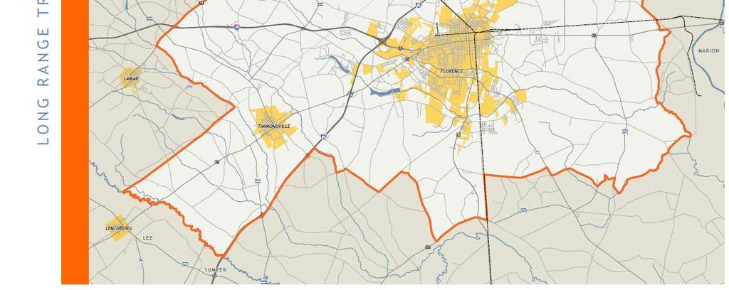
10 Study Area Changes
11 Planning Process Discovery Phase Plan Framework & Alternatives Inviting Success Goal Setting Evaluation Funding Needs Assessment PROJECT Recommendations STRATEGY Final Plan Adoption Existing Conditions Prioritization Implementation We are here!
12 State of the Region Report Highlights demographics, economics, and transportation in the region Lays the groundwork for future recommendations People Community members use the transportation system every day to connect to education, jobs, cultural resources, recreational activities, and more. Making sure population trends are reflected in the transportation plan allows the system to adjust to anticipated changes and accommodate future demand and different lifestyles. Prosperity Transportation provides a foundation for the development of communities by providing access to employment, thereby providing a stepping stone for economic growth. Taking a closer look at employment hubs within the region allows for a better understanding of opportunities for multimodal connections. Mobility Florence s transportation system must strike a balance between serving the needs of existing residents, the local workforce, and visitors. The region needs viable accessibility and connections to regional infrastructure for economic vitality and to sustain its quality of life. Taking a closer look at existing infrastructure allows for better planning and the ability to be better stewards of resources.


13 Key Takeaways
14 Key Takeaways Population is aging, following nationwide trends


15 Key Takeaways Poverty is growing, increasing above both the National and State averages. About 20% of the study area was living below the poverty line in This was higher than both the State level at 17.9% and the National level at 15.5%. The highest poverty levels are located within and east of Florence, as well as surrounding Darlington and Timmonsville.
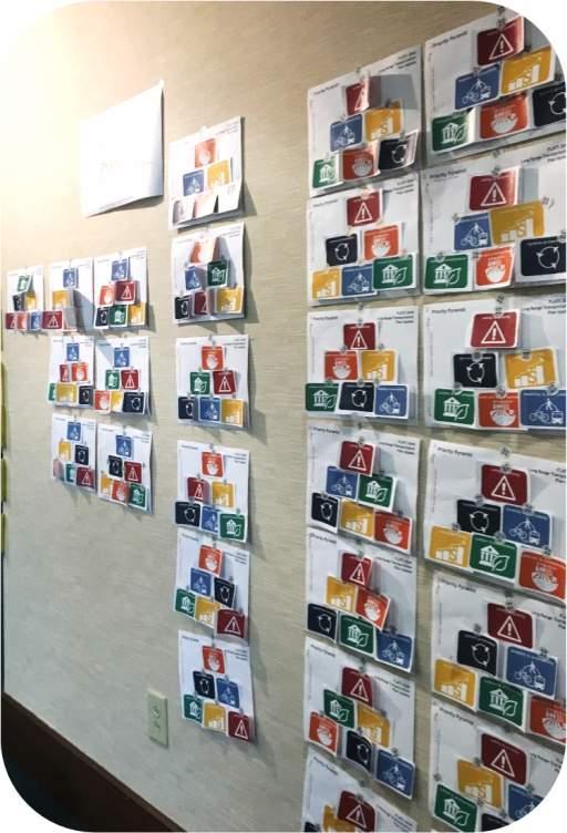
16 Public Outreach 2 Policy Committee Meetings INFORM ENGAGE 3 Steering Committee Meetings 2 Public Workshops Stakeholder/Small Group Sessions Online Survey


17 We asked people to describe: Today s Transportation System Future s Transportation System


18 Guiding Principles Promoting a safe and secure transportation system by reducing crashes and improving emergency response Extending the life of the transportation system by emphasizing maintenance and long-term viability Providing a balanced transportation system that makes it easier to bike, walk, or take transit Coordinating transportation investments with land use and development decisions Support the local economy by making it easier to move people and freight around and through the Region Preserving and promoting the Region s valued places and natural assets


19 We asked people to tell us what s most important to them.

20 Roadway Prioritization SCDOT-driven process, standardized across the state Each project receives individual score according to its performance against standard criteria Criteria organized by plan s guiding principles Projects ranked according to their scores, and funding allocated to the highest ranking projects

21 Roadway Prioritization Criteria Culture & Environment Environmental Impacts Economic Vitality Truck Traffic Percentage Economic Development Potential Growth and Development Location on a Priority Network Consistency with local land use plans Mobility & Accessibility Traffic Volume & Congestion Alternative Transportation Solutions Safety & Security Accident Rate Intersection Alignment Status System Preservation & Efficiency Financial Viability/Cost Pavement Quality

22 Roadway Recommendations

23 Roadway Recommendations

24 Roadway Recommendations


25 Roadway Recommendations Collector Streets - enhance travel between local streets and arterials. The primary purpose of a collector street is to collect traffic from neighborhood and local level streets and distribute it to minor and major thoroughfares.


26 Bicycle & Pedestrian Recommendations Designates on-street and off-street bicycle facilities Coordinates with roadway recommendations to take advantage of incidental improvements
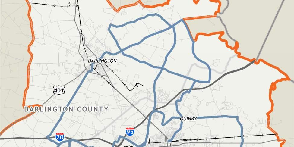
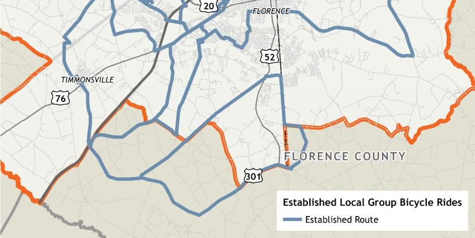
27 Bicycle & Pedestrian Recommendations

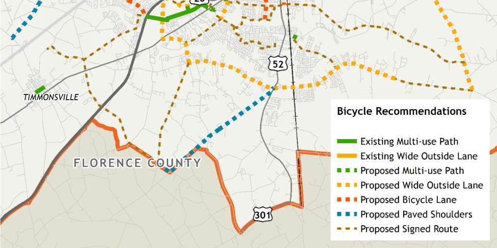
28 Bicycle & Pedestrian Recommendations


29 Other Recommendations Policy-level recommendations that help achieve a balanced system. Public Transportation ITS/TDM Advanced and Emerging Technologies Freight
30 Performance Measures New form of goaloriented transportation planning adopted by SCDOT and the Federal Highway Administration Requires MPOs to set targets for improving the performance of the regional transportation system Safety Highway Pavement Conditions Bridge Conditions Congestion System Reliability Freight Air Quality Safety is the first of eight required performance measures Development of Asset Management Plan

31 Performance Measures Safety SAFETY Safety performance measures introduced by SCDOT include: Number of fatalities Rate of fatalities per 100 million vehicle miles traveled Number of serious injuries Rate of serious injuries per 100 million vehicle miles traveled Number of non-motorized fatalities Number of non-motorized serious injuries

32 Performance Measures - Safety SAFETY FLATS Performance Measure Target Baselines Number of fatalities Rate of fatalities per 100 million vehicle miles traveled Number of serious injuries Rate of serious injuries per 100 million vehicle miles traveled Number of non-motorized fatalities Number of non-motorized serious injuries Based on averages

33 Financial Constraint Roadway Projects Cost vs Revenues

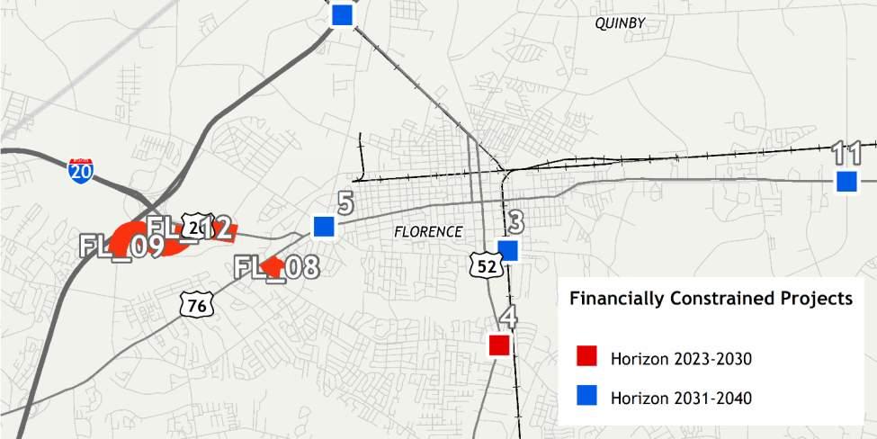
34 Financial Constraint Roadway Projects

35 Thank you!
Public Transportation and Bicycle & Pedestrian Stakeholder Webinar. April 11, :30 PM
 Public Transportation and Bicycle & Pedestrian Stakeholder Webinar April 11, 2013 1:30 PM Public Transportation and Bicycle & Pedestrian Webinar April 11, 2013 1:30 PM MULTIMODAL TRANSPORTATION PLAN Vision,
ACTIVE TRANSPORTATION
 ACTIVE TRANSPORTATION Mobility 2040 Supported Goals Improve the availability of transportation options for people and goods. Support travel efficiency measures and system enhancements targeted at congestion
Goal 3: Foster an environment of partnerships and collaboration to connect our communities and regions to one another.
 Non-Motorized Transportation Plan (NMTP) Draft Vision, Goal and,, Tri-County Regional Planning Commission (TCRPC) Purpose The purpose of the Tri-County Regional Planning Commission (TCRPC) Non-Motorized
Basalt Creek Transportation Refinement Plan Recommendations
 Basalt Creek Transportation Refinement Plan Recommendations Introduction The Basalt Creek transportation planning effort analyzed future transportation conditions and evaluated alternative strategies for
We believe the following comments and suggestions can help the department meet those goals.
 The Honorable Secretary Anthony Foxx The Secretary of Transportation United States Department of Transportation 1200 New Jersey Avenue, SE Washington, DC 20590 August 30, 2013 Dear Secretary Foxx, Thank
PEDESTRIAN ACTION PLAN
 ATTACHMENT 2 CITY OF SANTA MONICA PEDESTRIAN ACTION PLAN CITY OF SANTA MONICA PEDESTRIAN ACTION PLAN This page intentionally left blank EXECUTIVE SUMMARY CHAPTER 1 EXECUTIVE SUMMARY Setting the Stage
West Dimond Blvd Upgrade Jodhpur Street to Sand Lake Road
 West Dimond Blvd Jodhpur St to Sand Lake CSS Transportation Project Summary Municipality of Anchorage Project # 05 005 Project Manager: John Smith, P.E. (MOA PM&E) Project Administrator: Julie Makela,
Proposed. City of Grand Junction Complete Streets Policy. Exhibit 10
 Proposed City of Grand Junction Complete Streets Policy Exhibit 10 1 City of Grand Junction Complete Streets Policy Vision: The Complete Streets Vision is to develop a safe, efficient, and reliable travel
BETHEL ROAD AND SEDGWICK ROAD CORRIDOR STUDY
 DRAFT PLAN City Council Meeting August 14, 2017 STUDY AREA Sedgwick Corridor State Route 160, principal arterial with Class 3 access management designation, commuter and freight route, connection to SR
TOWN OF WILLIAMSTON, SC BICYCLE AND PEDESTRIAN MASTER PLAN TOWN OF WILLIAMSTON, SC BICYCLE AND PEDESTRIAN MASTER PLAN
 TOWN OF WILLIAMSTON, SC BICYCLE AND PEDESTRIAN MASTER PLAN Americans Want Choices 55% of Americans would rather drive less & walk more. Transit use is growing faster than population or highway travel.
City of Jacksonville Mobility Fee Update
 City of Jacksonville Mobility Fee Update 2017 Preliminary Analysis May 3, 2017 Carnival Cruise lines photo credit Presentation Overview Public Outreach Process Pedestrian and Bicycle Master Plan Study
City of Novi Non-Motorized Master Plan 2011 Executive Summary
 City of Novi Non-Motorized Master Plan 2011 Executive Summary Prepared by: February 28, 2011 Why Plan? Encouraging healthy, active lifestyles through pathway and sidewalk connectivity has been a focus
Draft MOBILITY ELEMENET. Community Meeting May 22, 2013
 Draft MOBILITY ELEMENET Community Meeting May 22, 2013 Agenda Presentation Ira Brown New Mobility Paradigm Movement of People Implementation Q&A Ira Brown and Dave Roseman Small Group Discussion at Each
City of Gainesville Transportation/Roadway Needs PROJECT SUMMARY
 A1 Roadway Resurfacing $23,846,000 TYPE: Preservation of existing system Roadway resurfacing A2 Signal Replacement $6,000,000 TYPE: Preservation of existing system Replace traffic signals. B1 W 6th St
Chapter 5 Future Transportation
 Chapter 5 Future Transportation The Future Land Use Plan identifies the desired land use designations. The land uses desired for Crozet depend, in large part, on the success of the transportation system,
EXECUTIVE SUMMARY. Vision
 Vision Walking and bicycling in Salt Lake City will be safe, convenient, comfortable, and viable transportation options that connect people to places, foster recreational and economic development opportunities,
Bicycle and Pedestrian Chapter TPP Update Overview. TAB September 20, 2017
 Bicycle and Pedestrian Chapter TPP Update Overview TAB September 20, 2017 Bicycling & Walking in the Twin Cities Where are we now? The Bike-Pedestrian system Current trends New developments Where are we
REGIONAL BICYCLE AND PEDESTRIAN DESIGN GUIDELINES
 REGIONAL BICYCLE AND PEDESTRIAN DESIGN GUIDELINES November 16, 2011 Deb Humphreys North Central Texas Council of Governments Bicycle and Pedestrian Advisory Committee Snapshot of the Guide 1. Introduction
Bicycle and Pedestrian Plans and Improvements
 Bicycle and Pedestrian Plans and Improvements Presented to the City Council By Randle Harwood, Planning and Development, and Richard Zavala, Parks and Community Services September 24, 2013 Purpose Review
ADOT Statewide Bicycle and Pedestrian Program Summary of Phase IV Activities APPENDIX B PEDESTRIAN DEMAND INDEX
 ADOT Statewide Bicycle and Pedestrian Program Summary of Activities APPENDIX B PEDESTRIAN DEMAND INDEX May 24, 2009 Pedestrian Demand Index for State Highway Facilities Revised: May 29, 2007 Introduction
APPENDIX G: INTERSECTION NEEDS AT OKEECHOBEE BOULEVARD
 APPENDIX G: INTERSECTION NEEDS AT OKEECHOBEE BOULEVARD INTERSECTION NEEDS AT SR 7 and OKEECHOBEE BOULEVARD SR 7 Extension Project Development and Environment (PD&E) Study From Okeechobee Boulevard (SR
Exhibit 1 PLANNING COMMISSION AGENDA ITEM
 Exhibit 1 PLANNING COMMISSION AGENDA ITEM Project Name: Grand Junction Circulation Plan Grand Junction Complete Streets Policy Applicant: City of Grand Junction Representative: David Thornton Address:
Project Update May 2018
 Project Update May 2018 Dakota County, in cooperation with the City of Lakeville, is planning to reconstruct 202 nd Street West (County Road 50) from Holyoke Avenue to Cedar Avenue (County Road 23). 202
AMATS Complete Streets Policy
 AMATS Complete Streets Policy Table of Contents: Section 1. Definition of Complete Streets Section 2. Principles of Complete Streets Section 3. Complete Streets Policy Section 4. Consistency Section 5.
Project Status Update
 Project Status Update : Novato Boulevard, 4th & 3rd Streets, Sir Francis Drake Boulevard (3), and Miller Avenue Major roads projects target the most heavily traveled roads in Marin County for repairs,
Chapter 2. Bellingham Bicycle Master Plan Chapter 2: Policies and Actions
 Chapter 2 Bellingham Bicycle Master Plan Chapter 2: Policies and Actions Chapter 2: Policies and Actions The Bicycle Master Plan provides a road map for making bicycling in Bellingham a viable transportation
Governor s Transportation Vision Panel
 Office of Governor Kate Brown Governor s Transportation Vision Panel JLA Public Involvement Project Overview The is a yearlong effort to develop a series of recommendations for the Governor that address
RESOLUTION NO ?? A RESOLUTION OF THE CITY OF NEPTUNE BEACH ADOPTING A COMPLETE STREETS POLICY
 RESOLUTION NO. 2018-?? A RESOLUTION OF THE CITY OF NEPTUNE BEACH ADOPTING A COMPLETE STREETS POLICY WHEREAS, safe, convenient, and accessible transportation for all users is a priority of the City of Neptune
2015 Florida Main Street Annual Conference. Complete Streets Equal Stronger Main Streets
 WHAT ARE COMPLETE STREETS? CASE STUDIES COMPLETING YOUR MAIN STREET 2015 Florida Main Street Annual Conference St. Petersburg, Florida August 19, 2015 WHAT ARE COMPLETE STREETS? CASE STUDIES COMPLETING
Living Streets Policy
 Living Streets Policy Introduction Living streets balance the needs of motorists, bicyclists, pedestrians and transit riders in ways that promote safety and convenience, enhance community identity, create
Transportation Master Plan Advisory Task Force
 Transportation Master Plan Advisory Task Force Network Alternatives & Phasing Strategy February 2016 BACKGROUND Table of Contents BACKGROUND Purpose & Introduction 2 Linking the TMP to Key Council Approved
I-20 ODESSA-MIDLAND CORRIDOR STUDY. Public Meeting for Schematic Design
 I-20 ODESSA-MIDLAND CORRIDOR STUDY Public Meeting for Schematic Design The environmental review, consultation, and other actions required by applicable Federal environmental laws for this project are being,
Performance Criteria for 2035 Long Range Transportation Plan
 Minimizing Impacts on Natural, Historic, Cultural or Archeological Resources 2035 LRTP Weighting Factor: 7% Objective 1.1: Use appropriate planning and design criteria to protect and enhance the built
Planning Guidance in the 2012 AASHTO Bike Guide
 Planning Guidance in the 2012 AASHTO Bike Guide Presentation by: RJ Eldridge Peter Lagerwey August 22, 2012 WEBINAR 2: PLANNING GUIDANCE IN THE 2012 AASHTO BIKE GUIDE Today s Webinar Significant Updates
TRASBURG RANSPORTATION
 TRASBURG RANSPORTATION LAN DEVELOPED BY THE TRANSPORTATION PLANNING DIVISION OF THE VIRGINIA DEPARTMENT OF TRANSPORTATION IN COOPERATION WITH THE U.S. DEPARTMENT OF TRANSPORTATION, FEDERAL HIGHWAY ADMINISTRATION
Kentucky s Surface Transportation System
 Kentucky s Surface Transportation System ROAD AND BRIDGE CONDITIONS, TRAFFIC SAFETY, TRAVEL TRENDS, AND NEEDS MARCH 2018 PREPARED BY WWW.TRIPNET.ORG Founded in 1971, TRIP of Washington, DC, is a nonprofit
Bluffdale/ UDOT South High-T Intersection Project Type Operations
 Bluffdale/ UDOT 14600 South High-T Intersection Project Type Operations 14600 South and Redwood Road $ 600,000 $ 550,000 This project is to install a new High-T intersection at Redwood Road and 14600 South
Stakeholder Update. Agenda. Project update Needs Identification Strategy Proposed needs Safety Collectors/Arterials Greenways Local roads
 1 Stakeholder Update May 21, 2018 2 Agenda Project update Needs Identification Strategy Proposed needs Safety Collectors/Arterials Greenways Local roads Proposed Evaluation Criteria Next Steps 1 Project/Schedule
Rhode Island Moving Forward Long-Range Transportation Plan 2040 Municipal Roundtable Providence County
 Rhode Island Moving Forward Long-Range Transportation Plan 2040 Municipal Roundtable Providence County www.planri.com PlanRI2040@gmail.com Municipal Roundtable Meeting Summary Date/time: Location: Tuesday,
Base Information. 1. Project Title County Line Road Shoulder Improvements. Start: County Line Road/17 th Avenue End: County Line Road/State Highway 66
 Part 1 Base Information 1. Project Title County Line Road Shoulder Improvements Start: County Line Road/17 th Avenue End: County Line Road/State Highway 66 2. Project Start/End points or Geographic Area
Multi-Modal Transportation Programs
 Multi-Modal Transportation Programs Supporting the Lawrence Strategic Plan Critical Success Factors: Safe, Healthy and Welcoming Neighborhoods Innovative Infrastructure & Asset Management Effective Governance
Omaha s Complete Streets Policy
 Omaha s Complete Streets Policy (Adopted August 2015) VISION To create great places and enhance our quality of life, the City of Omaha will provide safe, accessible streets for all users. Complete Streets
Environment and Public Works Committee Presentation
 Mixed Use Centers Complete Streets Guidelines Project Environment and Public Works Committee Presentation December 10, 2008 Project Objectives: Conduct an inter-departmental and agency process to study
ARTINSVILLE ENRY OUNTY REA RANSPORTATION TUDY
 ARTINSVILLE ENRY OUNTY REA RANSPORTATION TUDY DEVELOPED BY THE TRANSPORTATION AND MOBILITY PLANNING DIVISION OF THE VIRGINIA DEPARTMENT OF TRANSPORTATION IN COOPERATION WITH THE U.S. DEPARTMENT OF TRANSPORTATION,
Financial Project ID No(s).: and ETDM No(s).: and 14181
.: and ETDM No(s).: and 14181") Palm Beach Metropolitan Planning Organization (MPO) Presentation I-95 at Boynton Beach Boulevard Interchange and I-95 at Gateway Boulevard Interchange Project Development and Environment Study Palm Beach
Palm Beach Metropolitan Planning Organization (MPO) Presentation I-95 at Boynton Beach Boulevard Interchange and I-95 at Gateway Boulevard Interchange Project Development and Environment Study Palm Beach
Attachment A: Columbus Area Metropolitan Transportation Plan Objectives, Performance Measures, and Targets
 OBJECTIVE: Reduce the percentage of commuters driving alone, and increase the percentage of commuters riding transit, ing Reducing single occupancy auto commutes and increasing commuters using alternative
Transportation Assessment
 Transportation Assessment Midtown Open House February 10, 2018 Overview Midtown in Focus Overview & Purpose of Today Transportation Assessment overview Summary of Transportation work to date Review & Analysis
FMATS Transportation Improvement Program Non-Motorized Project Nomination Form
 Project nominations are accepted from the public and are scored based on the adopted Project Scoring Criteria. These criteria assign weight based on the project s impact on the following: 1. Health and
Better Market Street Project Update. Urban Forestry Council September 17, 2014
 Better Market Street Project Update Urban Forestry Council September 17, 2014 Project Area Limits Better Market Street Schedule Market Street City s busiest transit corridor Over 85 buses per hour 14 surface
CITY OF BLOOMINGTON COMPLETE STREETS POLICY
 CITY OF BLOOMINGTON COMPLETE STREETS POLICY POLICY OBJECTIVE: The City of Bloomington will enhance safety, mobility, accessibility and convenience for transportation network users of all ages and abilities,
Building Great Neighbourhoods QUEEN ALEXANDRA
 Building Great Neighbourhoods QUEEN ALEXANDRA We are here today to Explain how the City is investing in improving your neighbourhood and how your neighbourhood will be improved to meet current City standards.
Engineering - Bicycle and Pedestrian
 Capital Improvement Plan Project Summary # Bikeways Program 781,000 860,000 900,000 933,000 933,000 933,000 # Cannonball Path 1,200,000-780,000 - - - # Capital City Trail - 70,000 - - 910,000 - # Goodman
FMATS Transportation Improvement Program Project Nomination Form
 FMATS 2015 2018 Transportation Improvement Program Project Nomination Form Project nominations are accepted from the public and are scored based on the adopted Project Scoring Criteria. These criteria
Highway 49, Highway 351 and Highway 91 Improvements Feasibility Study Craighead County
 Highway 49, Highway 351 and Highway 91 Improvements Feasibility Study Craighead County Executive Summary March 2015 Highway 49, Highway 351 and Highway 91 Improvements Feasibility Study Craighead County
Final Sidewalk Feasibility Study
 Garfield Drive From Anastasia Drive to Elizabeth Place City of South Daytona July 23, 2009 Final Sidewalk Feasibility Study Prepared for: Prepared by: Final Sidewalk Feasibility Study Garfield Drive 2
Attachment One. Integration of Performance Measures Into the Bryan/College Station MPO FY 2019 FY 2022 Transportation Improvement Program
 Attachment One Integration of Performance Measures Into the Bryan/College Station MPO FY 2019 FY 2022 Transportation Improvement Program Introduction Begun as part of the Moving Ahead for Progress in the
WELCOME TO OPEN HOUSE # 1 June 14, 2017
 Langstaff Road Weston Road to Highway 7 Class Environmental Assessment Study WELCOME TO OPEN HOUSE # 1 June 14, 2017 Please sign in and join our mailing list Purpose of Open House #1 & Study Area York
AGENDA REPORT. Issue: Discussion of potential improvements on Barnwell Road at Niblick Drive
 AGENDA REPORT To: From: By: Honorable Mayor and City Council Members Warren Hutmacher, City Manager Tom Black, Public Works Director Date: March 23, 2016 Agenda: March 28, 2016 WORK SESSION AGENDA: Barnwell
MTP BICYCLE ELEMENT UPDATE. November 2017
 MTP BICYCLE ELEMENT UPDATE November 2017 TIME FOR AN UPDATE Bicycle Element adopted in July 2008 Almost 10 years old Many planned facilities have been implemented 10 years more experience in planning,
City of Hamilton s Transportation Master Plan (TMP) Public Consultation 3 December 2015
 Public Consultation 3 December 2015") City of Hamilton s Transportation Master Plan (TMP) Public Consultation 3 December 2015 McPhail Transportation Planning Services Ltd. AGENDA 6:00 7:00 pm Viewing Boards / Q & A with the Team 7:00 7:50
City of Hamilton s Transportation Master Plan (TMP) Public Consultation 3 December 2015 McPhail Transportation Planning Services Ltd. AGENDA 6:00 7:00 pm Viewing Boards / Q & A with the Team 7:00 7:50
SAN FRANCISCO MUNICIPAL TRANSPORTATION AGENCY
 THIS PRINT COVERS CALENDAR ITEM NO. : 11 DIVISION: Sustainable Streets BRIEF DESCRIPTION: SAN FRANCISCO MUNICIPAL TRANSPORTATION AGENCY Approving traffic modifications on Twin Peaks Boulevard between Christmas
City of Wayzata Comprehensive Plan 2030 Transportation Chapter: Appendix A
 A1. Functional Classification Table A-1 illustrates the Metropolitan Council s detailed criteria established for the functional classification of roadways within the Twin Cities Metropolitan Area. Table
Reams Road RCA Study. Board of County Commissioners Public Hearing
 Reams Road RCA Study Board of County Commissioners Public Hearing April 24, 2018 Presentation Overview Study Overview Existing Conditions Development of Alternatives Preferred Alternative Public Involvement
Speed Limits Study and Proposal. Public Input Session: 8/14/13
 Speed Limits Study and Proposal Public Input Session: 8/14/13 Why is Decatur a unique place for this project? First Community Transportation Plan in the nation with a Health Impact Assessment. Strong sense
Incorporating Health in Regional Transportation Planning
 Mayor Karl Dean, Chairman Incorporating Health in Regional Transportation Planning Leslie A. Meehan, AICP Center TRT Intervention Webinar January 29, 2013 Objectives for Today Background About the Nashville
Kelowna On the Move. Pedestrian and Bicycle Master Plan
 Kelowna On the Move Pedestrian and Bicycle Master Plan Executive Summary April 2016 Purpose of the Plan The Pedestrian and Bicycle Master Plan identifies infrastructure, planning, and policy requirements
City of Birmingham Draft Multi-modal Transportation Plan
 City of Birmingham Draft Multi-modal Transportation Plan City Commission Public Hearing Monday, November 25, 2013 7:30 pm Norman Cox, PLA, ASLA The Greenway Collaborative, Inc. Ann Arbor, Michigan The
SR 693 (Pasadena Avenue) Corridor Study from Shore Drive South to 66 th Street
 Corridor Study from Shore Drive South to 66 th Street") Welcome and Introduction Sign-in and comment sheets Restrooms and exits Meeting agenda and timeline Meeting goals / expectations Provide input to guide study recommendations Actively participate throughout
Welcome and Introduction Sign-in and comment sheets Restrooms and exits Meeting agenda and timeline Meeting goals / expectations Provide input to guide study recommendations Actively participate throughout
S.R. 3009, Section A20 South Park & Logan Road Intersection Improvement Project
 Open House Public Meeting S.R. 3009, Section A20 South Park & Logan Road Intersection Improvement Project Municipality of Bethel Park, Allegheny County Bethel Park Municipal Building 5001 West Library
Active Transportation Infrastructure Investment A Business Case
 Active Transportation Infrastructure Investment A Business Case In 2016, the Real Estate Foundation awarded the Capital Regional District a $50,000 grant for Shifting Gears: Land Use Change through Active
Goals, Objectives, and Policies
 Goals, Objectives, and Policies ADVISORY GROUP INPUT PUBLIC INPUT SNS PREVIOUS STUDIES RBPP Goals Vision Statement Southern Nevada will develop a safe, connected, and convenient walking and bicycling system
122 Avenue: 107 Street to Fort Road
 : 107 Street to Fort Road November 24, 2015 4:30 8:00 p.m. Meeting Purpose Summarize project work completed to date Share results of public input from Phase 1 Share the draft concept plan and proposed
CONNECTING PEOPLE TO PLACES
 CONNECTING PEOPLE TO PLACES 82 EAST BENCH MASTER PLAN 07 Introduction The East Bench transportation system is a collection of slow moving, treelined residential streets and major arteries that are the
City Council Briefing March 18, Draft Working Ideas for Confirmation of Direction
 City Council Briefing March 18, 2014 Draft Working Ideas for Confirmation of Direction Draft Working Ideas for Confirmation of Direction Overall Study Area Regional Population Growth Plan for Today and
Linking Transportation and Health in Nashville & Middle Tennessee
 Linking Transportation and Health in Nashville & Middle Tennessee Fit Nation New Orleans CPPW Mentoring Grant Built Environment Program May 14, 2011 Local Transportation Planning Framework Federal U.S.
Chapter 7. Transportation. Transportation Road Network Plan Transit Cyclists Pedestrians Multi-Use and Equestrian Trails
 Chapter 7 Transportation Transportation Road Network Plan Transit Cyclists Pedestrians Multi-Use and Equestrian Trails 7.1 TRANSPORTATION BACKGROUND The District of Maple Ridge faces a number of unique
Public Information Meeting. Orange Camp Road. Dr. Martin Luther King Jr. Beltway to I-4. Presented by: Volusia County August 2, 2018
 Public Information Meeting Orange Camp Road Dr. Martin Luther King Jr. Beltway to I-4 Presented by: Volusia County August 2, 2018 1 Project Goals To improve the operations and safety for Orange Camp Road
4. Action Plan & Projects
 4. Action Plan & Projects 45 46 ACTION PLAN AND PROJECTS The Action Plan organizes the list of transportation projects described in the Mobility Framework Plan section into short-term (0-5 years) and long-term
University of Victoria Campus Cycling Plan Terms of Reference. 1.0 Project Description
 University of Victoria Campus Cycling Plan Terms of Reference 1.0 Project Description The Campus Cycling Plan, a first for the University, will provide a comprehensive and coordinated approach to support
Recommended Roadway Plan Section 2 - Land Development and Roadway Access
 Recommended Roadway Plan Section 2 - Land Development and Roadway Access SECTION 2 Land Development and Roadway Access 2.1 Land Use and Access Management The Federal Highway Administration (FHWA) defines
Building Great Neighbourhoods BONNIE DOON
 Building Great Neighbourhoods BONNIE DOON We Are Here Today To Explain the Neighbourhood Renewal Process Show you the Westwood Preliminary Design Ask for local knowledge Highlight the Local Improvement
Attached for your reference please find project updates on ongoing VDOT construction projects in Southampton County.
 SOUTHAMPTON COUNTY BOARD OF SUPERVISORS Regular Session i July 25, 2016 6. HIGHWAY MATTERS A. PLAN PROJECT UPDATES Attached for your reference please find project updates on ongoing VDOT construction projects
El Paso County 2040 Major Transportation Corridors Plan
 El Paso County 2040 Major Transportation Corridors Plan Connect-our-County Online Transportation User Survey Preliminary Results June 24, 2010 Years of Residence 2. How many years have you LIVED HERE?
ACTIVE TRANSPORTATION/NONMOTORIZED TRANSPORTATION
 ACTIVE TRANSPORTATION/NONMOTORIZED TRANSPORTATION BACKGROUND Active transportation, also known as nonmotorized transportation, is increasingly recognized as an important consideration when planning and
2. Context. Existing framework. The context. The challenge. Transport Strategy
 Transport Strategy Providing quality connections Contents 1. Introduction 2. Context 3. Long-term direction 4. Three-year priorities 5. Strategy tree Wellington City Council July 2006 1. Introduction Wellington
Thank you for this opportunity to discuss with you how we can work together to make our streets more complete.
 Thank you for this opportunity to discuss with you how we can work together to make our streets more complete. 1 2 3 Thank you for this opportunity to discuss with you how we can work together to make
TRANSPORTATION TRAINING TOPICS. April 6, 2010
 TRANSPORTATION TRAINING TOPICS April 6, 2010 Roles of Transportation Providers Context and Policy Makers Division of Transportation and Traffic Other City Operations Other Transportation Operators CMA
New Measure A Expenditure Categories DEFINITIONS OF ELIGIBLE EXPENDITURES Adopted March 8, 2007
 New Measure A Expenditure Categories DEFINITIONS OF ELIGIBLE EXPENDITURES Adopted March 8, 2007 City Street and County Road Maintenance Program The preservation and keeping of public street and road rights-of-way
Tulsa Metropolitan Area LONG RANGE TRANSPORTATION PLAN
 Tulsa Metropolitan Area LONG RANGE TRANSPORTATION PLAN Indian Nations Council of Governments August 2005 CONTACTING INCOG In developing the Destination 2030 Long Range Transportation Plan, INCOG s Transportation
APPENDIX A: Complete Streets Checklist DRAFT NOVEMBER 2016
 APPENDIX A: Complete Streets Checklist DRAFT NOVEMBER 2016 Complete Streets Checklist MetroPlan Orlando s Complete Streets Checklist is an internal planning tool for staff to further implementation of
WEST AND SOUTH WEST RING ROAD DOWNSTREAM TRAFFIC IMPACTS
 Page 1 of 9 EXECUTIVE SUMMARY Alberta Transportation ( AT ) is preparing to construct the final sections of the Calgary Ring Road. This includes the South West Ring Road ( SWRR ) (from Lott Creek Blvd
Building Great Neighbourhoods LANSDOWNE
 Building Great Neighbourhoods LANSDOWNE We are here today to Explain how the City is investing in improving your neighbourhood and how your neighbourhood will be improved to meet current City standards.
Bikeable/Walkable Community Plan. Oct. 11, 2012 City Council Workshop
 Bikeable/Walkable Community Plan Oct. 11, 2012 City Council Workshop Background 2006 - O Fallon s population was 72,477. Citizen Survey showed a strong interest in additional bike & pedestrian opportunities.
BIKE PLAN CONTENTS GATEWAY
 CONTENTS Acknowledgments...vii Great Rivers Greenway District Board of Directors... vii Great Rivers Greenway District Staff... vii Project Consultants... vii Committees... viii Citizens Advisory Committee
Bicycle Master Plan Goals, Strategies, and Policies
 Bicycle Master Plan Goals, Strategies, and Policies Mobilizing 5 This chapter outlines the overarching goals, action statements, and action items Long Beach will take in order to achieve its vision of
CITY OF VAUGHAN EXTRACT FROM COUNCIL MEETING MINUTES OF OCTOBER 30, 2012
 CITY OF VAUGHAN EXTRACT FROM COUNCIL MEETING MINUTES OF OCTOBER 30, 2012 Item 31, Report No. 39, of the Committee of the Whole, which was adopted without amendment by the Council of the City of Vaughan
Solana Beach Comprehensive Active Transportation Strategy (CATS)
") Solana Beach Comprehensive Active Transportation Strategy (CATS) 3.0 Goals & Policies The Solana Beach CATS goals and objectives outlined below were largely drawn from the Solana Beach Circulation Element
Solana Beach Comprehensive Active Transportation Strategy (CATS) 3.0 Goals & Policies The Solana Beach CATS goals and objectives outlined below were largely drawn from the Solana Beach Circulation Element
Regional Transportation Needs Within Southeastern Wisconsin
 Regional Transportation Needs Within Southeastern Wisconsin #118274 May 24, 2006 1 Introduction The Southeastern Wisconsin Regional Planning Commission (SEWRPC) is the official areawide planning agency
Base Information. 1. Project Title Erie Parkway and WCR 7 Traffic Signal Project
 Part 1 Base Information 1. Project Title Erie Parkway and WCR 7 Traffic Signal Project 2. Project Start/End points or Geographic Area Provide a map with submittal, as appropriate 3. Project Sponsor (entity
Executive Summary June 2015
 Executive Summary June 2015 Highway 112 Corridor Study Benton and Washington Counties Executive Summary June 2015 Prepared by Transportation Planning and Policy Division Arkansas State Highway and Transportation