INDICATORS ON STREET & NEIGHBOURHOOD LEVEL. Ryan Martinson Tim Pharoah
|
|
|
- Lee Robbins
- 5 years ago
- Views:
Transcription
1 INDICATORS ON STREET & NEIGHBOURHOOD LEVEL Ryan Martinson Tim Pharoah

2 Why a difference between National/City and Street/Neighbourhood indicators?

3 there are a variety of treatments

4 there are a variety of functions

5 there are a variety of

6 Streets and Places needs to be context sensitive

7 North American Scan (2012)
8 What we want to discuss Approach for incorporating Street & Neighbourhood Level indicators At the community level, rigorous built environment level, project level Standardized vs Suggested vs Best Practices, Guidelines, What are the appropriate indicators? How do we operationalize these indicators?
9
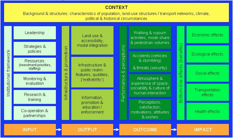
10 Input: Institutional Framework Main Criteria Leadership Strategies & Policies Resources Research & Training (Education) Co-operation & Partnerships Key performance indicators (or elements for creating them) Politicians and (senior) officials Extent to which politicians and (senior) officials take a lead and direction in supporting walking and public space improvements Walking strategy & integration of walking in other strategies Policy principles supporting walking (e.g. complete streets ) Implementation procedures Type of implementation programmes / action plans Type and degree of integration within Input level, i.e. between policies and resources Funding (incl. infrastructure investments, promotion, maintenance, research etc.) The level and continuity of funding for modes/projects a) with adverse effects on walking; b) for rectifying poor walking situations and c) to genuinely improve walking conditions / public spaces Public involvement / citizen participation in decision making, consultation Procedures, degree of decision-making powers Co-operation and dialogue with stakeholders outside government/administration NGO s, advocacy groups, economic interests (developers, retailers etc.), friendly forces and potential opponents
11 Output: Infrastructure & Promotion Main Criteria Land-use & modal integration Infrastructure & public space Key performance indicators (or elements for creating them) Land-use Land-use: functional mix; mixture and density of uses Distances, (macro-) accessibility & connectivity Distances to amenities / provisions / destinations ( walkscore / walkshed ), Modal integration Integration of walking with other modes, especially with public transport, cycling, car-share Accessibility of facilities at interchanges Walking network Length, density and extension of footpath network e.g. according to type/category: sidewalks, greenways/trails, other stand-alone footpaths, pedestrian areas, pedestrian priority areas, shared space Connectivity, permeability, detour factors, micro accessibility Space (unobstructed) Space allocated to pedestrians and sojourners, e.g. sidewalk width Amount of open spaces, spaces to relax, to stop, sit and/or stand Size of designated clear path, unobstructed walkways (opposite: density of obstructions) Seeing distances, visual perspectives (vistas) Pedestrian scale buildings & usages Type of ground floor usage / frontages (shops, cafés, etc.), diversity, uniqueness Dimensions of buildings and facades (human/pedestrian scale), quality; e.g. number or proportion of buildings with human scale front structures on street Proportions of building height to street width Aesthetics of buildings, e.g. allowing a sense of history and context ( landmarks )
12 Output: Infrastructure & Promotion Main Criteria Infrastructure & public space Key performance indicators (or elements for creating them) Quality of environment, provisions Green and blue on the street, i.e. trees, green areas, (accessible) water, fountains etc. Micro-/climate moderation and protection: sun, heat, rain, wind Seats provided: formal (benches) or informal (ledges), or in outdoor cafés; arrangement of seats (conducive to watching and interacting with other people) Availability of toilets and other services Street lighting, security Street lighting generally, pedestrian level street lighting & its quality: warm light Windows facing the streets, ground floor shops light up (no closed shutters) Number of people & activities in street spaces at night Crossings / road danger (safety) Number, location and quality of crossings: well marked, distances minimal, no detours (neither vertically nor horizontally) Traffic lights timed to needs of pedestrians: calculated crossing speed, waiting times Crossings and traffic lights equipped for mobility and sensory impaired pedestrians Street(s) with speed limit(s) lower than 30km/hr (20mph) or traffic calmed streets (e.g. proportionate to all streets); actual speeds driven (V85) above 30 km/hr Vehicles (illegally) parked obstructing space and overview for pedestrians Wayfinding (orientation and signage) Orientation/navigation intuitively possible, legible street design, clear vistas Wayfinding system in place for major destinations in area, Tools are easy to follow and consistent (maps, signage), landmark orientation
13 Output: Infrastructure & Promotion (cont) Main Criteria Infrastructure & public space Information, promotion & education/ enforcement Key performance indicators (or elements for creating them) Pollution & disturbance by motor traffic Intrusive motorized traffic: volume and composition of motorized traffic; number of on-street parking spaces in proportion to streets length or surface area Maintenance State of good repair (no holes and other stumbling elements, lights functioning) Cleanliness e.g. negatively measured as waste left on the ground per m2, dog poop Snow removed from walkways and transit stops in winter time (degree, efficiency, time) Co-operation with third parties Programmes together with third parties, NGO s, civil society, private companies etc. (e.g. events, services, communication etc.)
14 Outcome: Performance and Perceptions Main Criteria Walking activity, mode share pedestrian volumes & activity in public realm Key performance indicators (or elements for creating them) Walking activity / levels of walking Mode share of walking (in relation to other modes) People walking for exercise (leisure walking: hiking etc.) Children walking to school (unaccompanied) Pedestrian volumes & density Number of pedestrians per hour (according to day and night time, diff. seniors and kids and if they and if they walk alone) Density (crowdedness): number of pedestrians per meter street/path width (Fruin) Activity in the public realm; route choice Number of people in public spaces, activities performed (according to age, gender, social status, type and activity, groups day and night time, are seniors and women by their own present; kids playing, recording if they are accompanied) Intensity of use: average number per 100 m2 Time spent in public spaces, type of night activities Route choice & flows Car-related information Number of cars per household (share of car-free households) Short car trips (proportionate to all car trips; short = below 1km / 3 km)
15 Outcome: Performance and Perceptions Main Criteria Accidents & threats (safety & security) Key performance indicators (or elements for creating them) Road danger (safety) Traffic accidents with pedestrians (involving at least one vehicle): killed and severely injured pedestrians (relative to population and time walked) Percent of users who witnessed directly or indirectly a traffic accident in the area during the last 5 years (Actual) speeds being driven by motor vehicles Single pedestrian accidents Number of falling and stumbling accidents: Killed and severely injured pedestrians (relative to population and time walked) Security Density of crime; threats, attacks, harassments Number of people on street at night (according to gender and age), type of night activities
16 Outcome: Performance and Perceptions (cont) Main Criteria Atmosphere of space & culture of human interaction Perceptions, satisfaction & wishes Key performance indicators (or elements for creating them) Sociability & human interaction Social aspects: sociability, social interaction, conflicts (people showing affections, spontaneous friendly interactions; eye-contact between strangers; smiles etc. but possibly also conflicts and hostile encounters) Mood of space created by users Culture of human interaction between street users, e.g. respect shown by car drivers towards pedestrians Number and type of local activities (flea-markets, concerts, etc.) Sensory aspects: sounds, smell, tactile impressions etc. Appropriation of space by users Perceptions & satisfaction Personal satisfaction, happiness, comfort measuring the smiles Mental well-being, emotional responses in space
17 Impacts: Bottom-line Effects (Benefits) Main Criteria Economic effects Ecological effects Social effects Effects on transportation (system) Health effects Key performance indicators (or elements for creating them) Collective economic impacts More retail activity (shoppers) Possibly higher real-estate and rental prices (for shop owners, residents etc.) (=> adverse effects) Collective ecological impacts Reduced noise Reduced severance (better connections for people and animals) Reduced sealed surfaces => more permeability, flooding prevention Collective social impacts Increased social inclusion, more community cohesion, More social equality; democracy: participation for everyone in social life possible More peaceful interactions, less criminal offences Individual transportation impacts Time savings Collective transportation impacts Less need for transportation space Less congestion, higher efficiency Infrastructure cost savings
Welcome. Pre-conference Workshop WALK21, The Hague, 16 November Measuring Walking (part IV): Data Collection Methods
: Data Collection Methods") Welcome Pre-conference Workshop WALK21, The Hague, 16 November 2010 Measuring Walking (part IV): Data Collection Methods Daniel Sauter, Urban Mobility Research, Zurich, Switzerland Martin Wedderburn, Colin
Welcome Pre-conference Workshop WALK21, The Hague, 16 November 2010 Measuring Walking (part IV): Data Collection Methods Daniel Sauter, Urban Mobility Research, Zurich, Switzerland Martin Wedderburn, Colin
This objective implies that all population groups should find walking appealing, and that it is made easier for them to walk more on a daily basis.
 Walking for life The Norwegian Walking Strategy Guro Berge Norwegian public Roads Administration "Walking for life" is the slogan for the National Walking Strategy that is now being formulated in Norway.
City of Novi Non-Motorized Master Plan 2011 Executive Summary
 City of Novi Non-Motorized Master Plan 2011 Executive Summary Prepared by: February 28, 2011 Why Plan? Encouraging healthy, active lifestyles through pathway and sidewalk connectivity has been a focus
Welcome Pre-conference Workshop Walk21, Vienna, 20 October 2015
 Welcome Pre-conference Workshop Walk21, Vienna, 20 October 2015 Measuring Walking (part VII): International Walking Data Standard and its benefit Daniel Sauter, Urban Mobility Research, Zurich, Switzerland
DRAFT for a State Policy for Healthy Spaces and Places
 DRAFT for a State Policy for Healthy Spaces and Places 1 DRAFT State Policy for Healthy spaces and Places 1. Purpose To encourage the use and development of land that builds healthy communities through
4.1 Introduction. 4.2 Aspects of walkable communities
 4 Community walkability Community walkability Making communities walkable Urban form Feeling secure 4.1 Introduction Walkability describes the extent to which the built environment is walking-friendly.
2. Context. Existing framework. The context. The challenge. Transport Strategy
 Transport Strategy Providing quality connections Contents 1. Introduction 2. Context 3. Long-term direction 4. Three-year priorities 5. Strategy tree Wellington City Council July 2006 1. Introduction Wellington
Toronto Complete Streets Guidelines
 88 90 5.1 Cycling Design Principles 92 5.2 Context-sensitive Cycling Facilities 96 5.3 Key Cycling Elements Cycling infrastructure provides choice in how people are able to move around the city. Cyclists
complete streets design and construction standards public primer City of Edmonton
 complete streets design and construction standards public primer City of Edmonton introduction Complete Streets are streets for everyone: people who walk, wheel, bike, take transit, or drive. They are
Living Streets response to the Draft London Plan
 Living Streets response to the Draft London Plan Contents Living Streets response to the Draft London Plan... 1 About Living Streets... 2 Summary... 2 Consultation response... 3 Chapter 1: Planning London
Living Streets Policy
 Living Streets Policy Introduction Living streets balance the needs of motorists, bicyclists, pedestrians and transit riders in ways that promote safety and convenience, enhance community identity, create
EXECUTIVE SUMMARY: TRANSIT-ORIENTED DEVELOPMENT IN SMITHS FALLS, ONTARIO; A COMPARISON BETWEEN TWO SITES
 EECUTIVE SUMMARY: TRANSIT-ORIENTED DEVELOPMENT IN SMITHS FALLS, ONTARIO; A COMPARISON BETWEEN TWO SITES Topic and Purpose In 2007, the Mayor of Ottawa s Task Force on Transportation suggested adding a
NAIROBI NMT POLICY REGIONAL CONSULTATION ON AIR QUALITY, CLEAN VEHICLES AND SUSTAINABLE MOBILITY ROADMAP
 REGIONAL CONSULTATION ON AIR QUALITY, CLEAN VEHICLES AND SUSTAINABLE MOBILITY ROADMAP NAIROBI NMT POLICY M. N. KUIYAKI ROADS, PUBLIC WORKS & TRANSPORTAT SECTOR 25TH AUGUST 2016 PRESENTATION OUTLINE Introduction
CHAPTER 3: Vision Statement and Goals
 Davidson Walks & Rolls: Active Transportation Master Plan CHAPTER 3 Contents: Overview Vision Statement Measurable Goals Public Outreach CHAPTER 3: Vision Statement and Goals Overview The vision statement
Active Transportation Infrastructure Investment A Business Case
 Active Transportation Infrastructure Investment A Business Case In 2016, the Real Estate Foundation awarded the Capital Regional District a $50,000 grant for Shifting Gears: Land Use Change through Active
Tonight is for you. Learn everything you can. Share all your ideas.
 Strathcona Neighbourhood Renewal Draft Concept Design Tonight is for you. Learn everything you can. Share all your ideas. What is Neighbourhood Renewal? Creating a design with you for your neighbourhood.
CITY OF BLOOMINGTON COMPLETE STREETS POLICY
 CITY OF BLOOMINGTON COMPLETE STREETS POLICY POLICY OBJECTIVE: The City of Bloomington will enhance safety, mobility, accessibility and convenience for transportation network users of all ages and abilities,
TRANSPORTATION NEEDS ASSESSMENT
 TRANSPORTATION NEEDS ASSESSMENT A travel demand analysis was carried out to determine the operational issues and the potential benefit that adding traffic capacity would have on the road network. All the
Corpus Christi Metropolitan Transportation Plan Fiscal Year Introduction:
 Introduction: The Safe, Accountable, Flexible, Efficient Transportation Equity Act: A Legacy for Users (SAFETEA-LU) has continued the efforts started through the Intermodal Surface Transportation Efficiency
COUNCIL POLICY NAME: COUNCIL REFERENCE: 06/119 06/377 09/1C 10llC 12/1C INDEX REFERENCE: POLICY BACKGROUND
 COUNCIL POLICY NAME: COUNCIL ADVISORY COMMITTEES - TERMS OF REFERENCE ISSUED: APRIL 3, 2006 AMENDED: NOVEMBER 27, 2006 NOVEMBER 23, 2009 JANUARY 11, 2010 DECEMBER 17, 2012 POLICY COUNCIL REFERENCE: 06/119
All Season Age Friendly Pedestrian Safety and Walkability Checklist *
 FOSTERING AGE FRIENDLY, WALKABLE NEIGHBOURHOODS Walkability is a key component of optimal aging in Age Friendly cities. Walkable neighbourhoods promote physical and mental health and well-being, support
Canada s Capital Region Delegation to the Velo-City Global 2010 Conference
 Canada s Capital Region Delegation to the Velo-City Global 2010 Conference Report of Findings from Visits, Meetings & Presentations In Amsterdam-Den Haag, Utrecht, Berlin & Copenhagen The Itinerary Copenhagen
Active Travel Strategy Dumfries and Galloway
 Active Travel Strategy Dumfries and Galloway Our Active Travel Strategy The agreed Interventions for Dumfries and Galloway Council s Local Transport Strategy includes an action to Develop an Active Travel
CHAPTER 7.0 IMPLEMENTATION
 CHAPTER 7.0 IMPLEMENTATION Achieving the vision of the Better Streets Plan will rely on the ability to effectively fund, build and maintain improvements, and to sustain improvements over time. CHAPTER
WEST YORKSHIRE LTP CYCLE PROSPECTUS
 WEST YORKSHIRE LTP CYCLE PROSPECTUS The West Yorkshire Ambition: To be recognised as a great place for safe cycling, inspiring more people to cycle more often. INTRODUCTION Cycling is low cost, environmentally
LEA BRIDGE ROAD - A STREET FOR EVERYONE Public consultation document
 LEA BRIDGE ROAD - A STREET FOR EVERYONE Public consultation document TELL US Bakers Arms to Leyton Green Road (Section D, E, F) Leyton Green Road to Whipps Cross Roundabout (Section G) YOUR VIEWS www.enjoywalthamforest.co.uk
Exhibit 1 PLANNING COMMISSION AGENDA ITEM
 Exhibit 1 PLANNING COMMISSION AGENDA ITEM Project Name: Grand Junction Circulation Plan Grand Junction Complete Streets Policy Applicant: City of Grand Junction Representative: David Thornton Address:
Strategy for Walking & Cycling Action Plan
 Strategy for Walking & Cycling Action Plan To achieve higher levels of walking and cycling activity, the destinations which people access have to be available within suitable distances and designed to
Washington County, Oregon
 Washington County, Oregon Photo add here 1 Washington County, Oregon Total population: 536,370 City population: 320,000 Based on 2010 Census Rural population: 26,000 Urban Unincorporated Population: 190,000
City of Toronto Complete Streets Guidelines
 Round One This is a summary of the Complete Streets Guidelines Survey posted on June 18 th, 2015 and live until July 2 nd, 2015. The survey was designed to solicit feedback on the draft Complete Streets
Proposed. City of Grand Junction Complete Streets Policy. Exhibit 10
 Proposed City of Grand Junction Complete Streets Policy Exhibit 10 1 City of Grand Junction Complete Streets Policy Vision: The Complete Streets Vision is to develop a safe, efficient, and reliable travel
Ann Arbor Downtown Street Plan
 1 Ann Arbor Downtown Street Plan Public Workshop #1 We know that. 2 Public right-of-way (streets, sidewalks, and alleys) make up 30% of the total District area of downtown. Streets need to provide mobility
SUPPORTING DOCUMENTATION PROPOSED TRAILS DEVELOPMENT AND IMPLEMENTATION PLAN
 SUPPORTING DOCUMENTATION PROPOSED TRAILS DEVELOPMENT AND IMPLEMENTATION PLAN Prepared For: Prepared By: Town of Rocky Mountain House Recreation, Parks and Community Services 1 INTRODUCTION 1.1 Purpose
Kevin Manaugh Department of Geography McGill School of Environment
 Kevin Manaugh Department of Geography McGill School of Environment Outline Why do people use active modes? Physical (Built environment) Factors Psychological Factors Empirical Work Neighbourhood Walkability
Evolution of urban transport policies: International comparisons
 Centre for Transport Studies Evolution of urban transport policies: International comparisons Prof Peter Jones Centre for Transport Studies, UCL Presentation to the IATSS GIFTS Workshop, November 2015
Ormond & McKinnon Walks Response to Draft Glen Eira Community Plan
 Response to Draft Glen Eira Community Plan We would like to take this opportunity to thank Glen Eira City Council for the opportunity to comment on the Glen Eira Draft Community Plan. Below is an outline
CONNECTING PEOPLE TO PLACES
 CONNECTING PEOPLE TO PLACES 82 EAST BENCH MASTER PLAN 07 Introduction The East Bench transportation system is a collection of slow moving, treelined residential streets and major arteries that are the
Birmingham Connected. Edmund Salt. Transportation Policy Birmingham City Council
 Birmingham Connected Edmund Salt Transportation Policy Birmingham City Council www.birmingham.gov.uk/connected Birmingham Connected the story so far Broadly following EU Guidance We ve done all of this
RESOLUTION NO ?? A RESOLUTION OF THE CITY OF NEPTUNE BEACH ADOPTING A COMPLETE STREETS POLICY
 RESOLUTION NO. 2018-?? A RESOLUTION OF THE CITY OF NEPTUNE BEACH ADOPTING A COMPLETE STREETS POLICY WHEREAS, safe, convenient, and accessible transportation for all users is a priority of the City of Neptune
Part B Design Guidance / Principles _
 Part B Design Guidance / Principles www. landlab.co.nz Queenstown Town Centre Public Realm Design Guidelines Version 7 14 June 2018 Page 006 B1 Design Guidance & Best Practice The Queenstown Town Centre
21.07 TRANSPORT CONNECTIVITY AND INFRASTRUCTURE
 21.07 TRANSPORT CONNECTIVITY AND INFRASTRUCTURE 21.07-1 Connectivity and Choice Transport connectivity and mode choice are critical to achieving productive, sustainable and socially just cities. Travel
Creating walkable, bikeable and transit-supportive communities in Halton
 Creating walkable, bikeable and transit-supportive communities in Halton By presenting current research and best practices, the information in this paper is meant to support and broaden discussion on how
Launceston's Transport Futures. Greater travel options for the people of Launceston
 Launceston's Transport Futures Greater travel options for the people of Launceston Final Draft 13 Jan 2014 1 Page Number Executive summary 3 What is Transport Futures? 4 Vision 6 Economy, access and liveability
WALKABILITY SURVEY IN ASIAN CITIES
 WALKABILITY SURVEY IN ASIAN CITIES This section describes the methodology of the surveys for the benefit of the enumerators (surveyors) with some sample maps for illustration. The methodology for the survey
NOTES FROM JUNIOR COUNCIL ORIENTATION SESSION HELD ON MONDAY, JANUARY 22, 2018, AT 3:30 PM IN COUNCIL CHAMBERS, CITY HALL
 CITY OF KAMLOOPS Junior Council Meeting Agenda March 12, 2018, at 3:30 pm in Council Chambers, 7 Victoria Street West, Kamloops, BC Page 1. APPROVAL OF THE AGENDA 2. MINUTES Attachment Recommendation:
RESTRICTED ROADS (20 MPH SPEED LIMIT) (SCOTLAND) BILL. 1. Is reducing the speed limit to 20mph the best way of achieving the aims of the Bill?
 (SCOTLAND) BILL. 1. Is reducing the speed limit to 20mph the best way of achieving the aims of the Bill?") RURAL ECONOMY AND CONNECTIVITY COMMITTEE RESTRICTED ROADS (20 MPH SPEED LIMIT) (SCOTLAND) BILL SUBMISSION FROM CYCLE STIRLING Questions 1. Is reducing the speed limit to 20mph the best way of achieving
RURAL ECONOMY AND CONNECTIVITY COMMITTEE RESTRICTED ROADS (20 MPH SPEED LIMIT) (SCOTLAND) BILL SUBMISSION FROM CYCLE STIRLING Questions 1. Is reducing the speed limit to 20mph the best way of achieving
EXECUTIVE SUMMARY. Vision
 Vision Walking and bicycling in Salt Lake City will be safe, convenient, comfortable, and viable transportation options that connect people to places, foster recreational and economic development opportunities,
Civil Society. Dialogue for Progress
 By Madona Gasanova It took George, 15, about two years to rebuild his life aſter getting hit by a car on his way to school. He is lucky to still be alive; other people are not so lucky. In George's words,
The previous chapters in this plan have established the value of this plan (Chapter 1), the
, the") 4 Making Madison an Even Better Place to Walk: Vision, Goals, Objectives The previous chapters in this plan have established the value of this plan (Chapter 1), the importance of walking (Chapter 2), and
4 Making Madison an Even Better Place to Walk: Vision, Goals, Objectives The previous chapters in this plan have established the value of this plan (Chapter 1), the importance of walking (Chapter 2), and
Complete Streets. Designing Streets for Everyone. Sarnia
 Complete Streets Designing Streets for Everyone Sarnia Complete Streets ~ Sarnia ~ 2018 Introduction Our City is made up of a network of streets that we use to go for a walk, cycle to work, drive to the
PRINCE GEORGE S PLAZA METRO AREA PEDESTRIAN PLAN
 PRINCE GEORGE S PLAZA METRO AREA PEDESTRIAN PLAN May 28, 2008 Agenda Welcome and introductions Project overview and issue identification Planning context and strengths Design challenges and initial recommendations
How to Develop a Pedestrian Safety Action Plan
 How to Develop a Pedestrian Safety Action Plan Course Introduction Presented by: Peter Eun FHWA RC Safety Engineer Ryan Snyder President, Ryan Snyder Associates, LLC Paul Zykofsky Director, Land Use and
Bicycle Master Plan Goals, Strategies, and Policies
 Bicycle Master Plan Goals, Strategies, and Policies Mobilizing 5 This chapter outlines the overarching goals, action statements, and action items Long Beach will take in order to achieve its vision of
Christchurch 3 years on: - growing resilience
 Christchurch 3 years on: - growing resilience Presentation to Road Controlling Authorities Forum 9 May 2014 Michael Blyleven Presentation Outline The Earthquakes The Damage The Recovery Plan An Accessible
TOWN OF PORTLAND, CONNECTICUT COMPLETE STREETS POLICY
 TOWN OF PORTLAND, CONNECTICUT COMPLETE STREETS POLICY I. VISION, GOALS & PRINCIPLES VISION To improve the streets of Portland making them safer and more accessible for all users including pedestrians,
Will development of SUMPs improve Mobility Management in Lithuania?'
 Will development of SUMPs improve Mobility Management in Lithuania?' ENDURANCE NFP Policy Exchange Ryga 2016-02-24 James McGeever 2013 TAEM Urbanistai. Visos teisės saugomos. 1. Introduction 2. Understanding
12 RECOMMENDATIONS Road Improvements. Short Term (generally the next five years)
") 12 RECOMMENDATIONS Recommendations are based on the technical analysis of existing and future road and active transportation conditions, the results of the review of existing City policies and public feedback.
12 RECOMMENDATIONS Recommendations are based on the technical analysis of existing and future road and active transportation conditions, the results of the review of existing City policies and public feedback.
STONY PLAIN ROAD STREETSCAPE
 Jasper Place Revitalization Strategy: Vision The people involved in the Jasper Place Revitalization Strategy envision: Goal 1: Feeling safe in our community Create a community where feeling safe is common--where
PEDESTRIAN ACTION PLAN
 ATTACHMENT 2 CITY OF SANTA MONICA PEDESTRIAN ACTION PLAN CITY OF SANTA MONICA PEDESTRIAN ACTION PLAN This page intentionally left blank EXECUTIVE SUMMARY CHAPTER 1 EXECUTIVE SUMMARY Setting the Stage
TOWARDS A BIKE-FRIENDLY CANADA A National Cycling Strategy Overview
 TOWARDS A BIKE-FRIENDLY CANADA A National Cycling Strategy Overview NationalCyclingStrategFrameworkv3.indd 1 Potential for this modal shift can be found in municipalities of all sizes, in every population
Community Improvement Plans: Creating walkable and liveable communities that support local business
 Community Improvement Plans: Creating walkable and liveable communities that support local business Kate Hall Program Manager ~ WALK Friendly Ontario Canada Walks, Green Communities Canada khall@greencommunitiescanada.org
Bridgewater Complete Streets Prioritization Plan and Pedestrian Safety Assessment
 Bridgewater Complete Streets Prioritization Plan and Pedestrian Safety Assessment Presented by Luciano Rabito Manager of Complete Streets Presented to Bridgewater, MA Wednesday, April 26, 2017 6:30 P.M.
Bicycle and Pedestrian Advisory Committee (BPAC) November 21, 2013
 November 21, 2013") Bicycle and Pedestrian Advisory Committee (BPAC) November 21, 2013 OVERALL LAND USE CONCEPT Overall Broadway Valdez District: 95.5 acres (35.1 acres right-of ways + 60.4 acres developable land) Plan Subareas:
Bicycle and Pedestrian Advisory Committee (BPAC) November 21, 2013 OVERALL LAND USE CONCEPT Overall Broadway Valdez District: 95.5 acres (35.1 acres right-of ways + 60.4 acres developable land) Plan Subareas:
Bike share success factors
 Bike share success factors A guide to the types of locations where bike share can flourish January 2016 Bike share success factors A guide to the types of locations where bike share can flourish and how
Douglas Land Use and Transportation Strategy (DLUTS) Summary. August 2013
 Summary. August 2013") Douglas Land Use and Transportation Strategy (DLUTS) Summary August 2013 Background Douglas is a large and popular residential suburb of approximately 30,000 persons on the periphery of Cork City along
Douglas Land Use and Transportation Strategy (DLUTS) Summary August 2013 Background Douglas is a large and popular residential suburb of approximately 30,000 persons on the periphery of Cork City along
VILNIUS SUMP. Gintarė Krušinskaitė International project manager place your logo here
 VILNIUS SUMP Gintarė Krušinskaitė International project manager Gintare.krusinskaite@vilniustransport.lt place your logo here 19 April, 2017 WHERE DID WE CAME FROM? Mobility management and mobility planning
Section 2 Strategic Alignment. Contents
 Section 2 Strategic Alignment Contents 2 Strategic Alignment... 2 2.1 General... 2 2.2 SmartGrowth Strategy and Implementation Plan... 2 2.3 Walking and Cycling Strategy... 3 2.4 Built Environment Strategy...
University of Victoria Campus Cycling Plan Terms of Reference. 1.0 Project Description
 University of Victoria Campus Cycling Plan Terms of Reference 1.0 Project Description The Campus Cycling Plan, a first for the University, will provide a comprehensive and coordinated approach to support
Mumford Terminal Replacement Opportunities Neighbourhood Open House. we are here. PHASE 2 Identifying and Evaluating Candidate Sites
 Welcome Replacement Opportunities Neighbourhood Open House. AGENDA PURPOSE 1. REVIEW the information boards 2. DISCUSS aspects of the project with the project team 3. SHARE your thoughts on replacement
Frequently asked questions about how the Transport Walkability Index was calculated are answered below.
 Transport Walkability Index The Transport Walkability Index is a relative indicator of how well the built environment in different areas supports walking for transport. The index is frequently used in
Agency Advisory Group Meeting #3 and Walk Audit Anchorage Non-Motorized Plan
 Agency Advisory Group Meeting #3 and Walk Audit Anchorage Non-Motorized Plan Friday, May 18 th Walk Audit 10:00-11:30 AM Meeting 11:30 AM 1:00 PM Municipal Planning Department, 4700 Elmore Road, Training
Urban Transport Policy-making changing perspectives and consequences
 Urban Transport Policy-making changing perspectives and consequences Peter Jones, UCL ITLS, University of Sydney, 28 th March 2018 Overview Changing urban transport policy perspectives From car-based to
What s Health Got to Do With It? Health and Land Use Planning
 What s Health Got to Do With It? Health and Land Use Planning CANDACE RUTT, PH.D. EXECUTIVE DIRECTOR APRIL 13 TH, 2016 Planning and Public Health Planning + Public Health Healthy Communities Healthier
Bikeway action plan. Bicycle Friendly Community Workshop March 5, 2007 Rochester, MN
 Bikeway action plan Summary The was held on March 5, 2007 at the Rochester Mayo Civic Center. The workshop was hosted by Rochester-Olmsted County Planning Department in collaboration with the League of
Major Bike Routes 102 Avenue Workshop April 21, 2015
 Major Bike Routes 102 Avenue Workshop April 21, 2015 Our Purpose Today Provide context on how Major Bike Routes fit into Edmonton s future Share information on what we heard in our last phase, and how
Pedestrian Crosswalk Audit
 1200, Scotia Place, Tower 1 10060 Jasper Avenue Edmonton, Alberta T5J 3R8 edmonton.ca/auditor Pedestrian Crosswalk Audit June 19, 2017 The conducted this project in accordance with the International Standards
City of Ottawa s Complete Streets Approach to Transportation Projects
 City of Ottawa s Complete Streets Approach to Transportation Projects Presentation to Stakeholders Date: May 5, 2015 Presentation Overview Purpose of the study Proposed definition of Complete Streets for
9/21/2016 VIA . RE: The Knot (DR16-270)
") 9/21/2016 VIA EMAIL Garrett Norman, Assistant Planner City of Sacramento Community Development Department 300 Richards Boulevard, 3 rd Floor Sacramento, CA 95811 RE: The Knot (DR16-270) Dear Mr. Norman:
9/21/2016 VIA EMAIL Garrett Norman, Assistant Planner City of Sacramento Community Development Department 300 Richards Boulevard, 3 rd Floor Sacramento, CA 95811 RE: The Knot (DR16-270) Dear Mr. Norman:
NATIONAL ACTION STRATEGY A VOICE FOR WALKING
 NATIONAL ACTION STRATEGY A VOICE FOR WALKING Canadians are coming together to create a unified voice for walking and to pick up the pace of action for walkable communities. Our goal: to restore everyday
Goal 3: Foster an environment of partnerships and collaboration to connect our communities and regions to one another.
 Non-Motorized Transportation Plan (NMTP) Draft Vision, Goal and,, Tri-County Regional Planning Commission (TCRPC) Purpose The purpose of the Tri-County Regional Planning Commission (TCRPC) Non-Motorized
About the Active Transportation Alliance
 About the Active Transportation Alliance Chicagoland s voice for better biking, walking and transit Founded 1985 7,000 members, ~33 full time staff Serve Chicago metro region 1 More Cars, More Driving
Urban Street Design and Development
 Urban Street Design and Development Ashok Bhattacharjee, Advisor, Clean Air and Sustainable Mobility, Centre for Science and Environment CSE Workshop on Safe Access and Parking - Lytton Hotel, Kolkata
05 Pilot Projects 68
 05 Pilot Projects 68 Gehl Studio 69 Pilot Projects in Columbus The hundreds of comments shared at the Focus Area workshops helped identify opportunities for pilot projects to test out Columbus vision and
Delivering the. Strategy 7.0
 7.0 Delivering the Strategy 7.1 Introduction This chapter presents a framework for the delivery of the strategy. Key challenges and opportunities are identified that will have an impact on the successful
City of Charlottesville Bicycle and Pedestrian Master Plan Update
 City of Charlottesville Bicycle and Pedestrian Master Plan Update September 17, 2014 I. Welcome and meeting overview II. Project status update III. Network overview IV. Break-out groups Pedestrian Network
Chapter 7. Transportation. Transportation Road Network Plan Transit Cyclists Pedestrians Multi-Use and Equestrian Trails
 Chapter 7 Transportation Transportation Road Network Plan Transit Cyclists Pedestrians Multi-Use and Equestrian Trails 7.1 TRANSPORTATION BACKGROUND The District of Maple Ridge faces a number of unique
Making Brighton & Hove A Walkable City
 Making Brighton & Hove A Walkable City Living Streets Public Meeting 28 th November 2011, 7.30 pm Lord Nelson Inn 36 Trafalgar St, Brighton, BN1 4ED Tonight s Meeting Stephen Young Chairman, Brighton and
Agenda. Overview PRINCE GEORGE S PLAZA METRO AREA PEDESTRIAN PLAN
 PRINCE GEORGE S PLAZA METRO AREA PEDESTRIAN PLAN May 28, 2008 Agenda Welcome and introductions Project overview and issue identification Planning context and strengths Design challenges and initial recommendations
Walking and Cycling Action Plan Summary. A Catalyst for Change The Regional Transport Strategy for the west of Scotland
 Walking and Cycling Action Plan Summary A Catalyst for Change The Regional Transport Strategy for the west of Scotland 2007-2021 Strathclyde Partnership for Transport Contents Purpose...2 Issues, Constraints
A CHANGING CITY. of Edmonton, it is essential that it reflects the long-term vision of the City.
 A CHANGING CITY By the year 2040, Edmonton will be home to more than 1 million people. To accommodate growth and support a healthy and compact city, we need a new approach to development/redevelopment
12/4/2016 VIA . RE: Grocery Outlet Del Paso (DR16-328)
") 12/4/2016 VIA EMAIL Ethan Meltzer, Assistant Planner City of Sacramento Community Development Department 300 Richards Blvd, 3 rd Floor Sacramento, CA 95811 RE: Grocery Outlet Del Paso (DR16-328) Dear Mr.
12/4/2016 VIA EMAIL Ethan Meltzer, Assistant Planner City of Sacramento Community Development Department 300 Richards Blvd, 3 rd Floor Sacramento, CA 95811 RE: Grocery Outlet Del Paso (DR16-328) Dear Mr.
NM-POLICY 1: Improve service levels, participation, and options for non-motorized transportation modes throughout the County.
 Transportation PRINCE WILLIAM COUNTY 2008 COMPREHENSIVE PLAN NON-MOTORIZED PLAN CONTENTS Goals, Policies, and Action Strategies Table 4 (Bike Facility Classifications and Descriptions) Table 5 (Bike Facility
Westminster s Joint Health and Wellbeing Strategy
 Westminster s Joint Health and Wellbeing Strategy 2013 2016 Response from Sustrans General comments From a strategic perspective, Sustrans welcomes the Health and Wellbeing Strategy s focus on encouraging
Stakeholder Meeting Handouts. January 2013
 January 2013 Stakeholder Meeting Handouts The Case FOR Parking Minimum Requirements Reduce street congestion around the development site Avoid parking spillover Create orderly development patterns Anticipate
5. RUNNINGWAY GUIDELINES
 5. RUNNINGWAY GUIDELINES These guidelines should be considered collectively when making runningway decisions. A runningway is the linear component of the transit system that forms the right-of-way reserved
Bicycle Facilities Planning
 Bicycle Facilities Planning Overview Types of Cyclists Purpose for Riding Types of Facilities Bike Lanes Bicycle Boulevards Cycle Tracks Intersections Signals Signing and Marking Discussion Types of Bicyclists
Wayfinding and Walking in London. Lilli Matson Transport for London May 2013
 Wayfinding and Walking in London Lilli Matson Transport for London May 2013 I want to make walking in London as attractive and enjoyable as possible by making walking count Mayor of London Boris Johnson
WALK- AND bike-friendly TURLOCK
 WALK- AND bike-friendly TURLOCK Ideas to Encourage Walking and Biking Benefits to the COMMUNITY Get Connected People who walk and bike have many more opportunities for casual interactions with friends
DESIGNING STREETS FOR CITIZENS: UNEP SHARE THE ROAD PROGRAMME
 DESIGNING STREETS FOR CITIZENS: UNEP SHARE THE ROAD PROGRAMME Susan Wothaya Share the Road Programme UNEP, Transport Unit susan.wothaya@unep.org www.uneptransport/sharetheroad Content The Reality- transport
General Design Factors
 Chapter 3: 3-1.0 Introduction General Design Factors Mn/DOT s goals include encouraging and accommodating safe bicycling. From a design perspective, these goals are achieved by first having an understanding