Denver, Colorado. December 2005
|
|
|
- Myrtle Wilkins
- 5 years ago
- Views:
Transcription


1 Denver, Colorado December 2005


2 Acknowledgments Sponsoring Agencies: City and County of Denver Regional Transportation District Colorado Department of Transportation Denver Regional Council of Governments Downtown Denver Business Improvement District Consultant Team: Fehr & Peers Zimmer Gunsul Frasca Partnership Nelson/Nygaard PTV America Matrix Design Group Design Collaborative Ron Straka Pat Noyes & Associates Intermountain Corporate Affairs Governmental Agency Project Team (GAP): Mark Najarian, CCD Ellen Ittelson, CCD Tyler Gibbs, CCD David Weaver, CCD Catherine Cox-Blair, CCD John La Sala, CCD Mark Upshaw, CCD Dave Hollis, RTD Robert Rynerson, RTD Myron Swisher, CDOT Gregg Mugele, CDOT Jennifer Edwards, DRCOG John Desmond, DDP Brendon Harrington, DDP

3 Table of Contents Preface... 4 Historic Overview and Timeline... 6 Current Conditions... 8 Principles Guiding Downtown Transportation Decisions Transportation Recommendations Implementation... 26
, the Regional Transportation District (RTD), the Colorado Department of Transportation (CDOT),")
, pedestrian, bicycle and transit access into and throughout Downtown Denver over the next 20 to 25")
4 Downtown street circa 1930 Trolley service in the 1940s Pr e fa c e As Downtown Denver continues to grow and change, the transportation system must also grow and change. To ensure this evolution is timely, efficient and cost effective, the City and County of Denver (CCD), the Regional Transportation District (RTD), the Colorado Department of Transportation (CDOT), the Downtown Denver Business Improvement District (BID), and the Denver Regional Council of Governments (DRCOG) initiated the Downtown Multimodal Access Plan (DMAP). The main goal of the DMAP is an integrated plan for vehicular, freight (primarily delivery services), pedestrian, bicycle and transit access into and throughout Downtown Denver over the next 20 to 25 years. Key elements of plan development are the relationship between land use and transportation, major infrastructure improvements and the important urban design role streets play in creating quality connections between destinations, people, individual land uses and surrounding neighborhoods. The importance of DMAP is illustrated with several observations and trends: Over the past several decades, Downtown has shifted from being a 9-to-5 office employment center to being an all day educational center, residential neighborhood, cultural and entertainment center and transit hub, as well as an office employment center. Rail transit has re-emerged as a significant mode. The passage of FasTracks in November 2004 indicates a significant shift away from the auto-related improvements that dominated the previous 50 years. Public streets, sidewalks and alleys comprise about 40 percent of the land area of Downtown, so the rights-ofway have a major impact on the perception of Downtown as a vital and attractive place. The public right-of-way is finite, and many uses compete for this limited space daily movements of pedestrians, automobiles, bicycles, buses, trains and delivery vehicles; access to private properties; commercial activities such as outdoor cafes and street vendors; and occasional public activities such as parades, festivals and demonstrations. Downtown is no longer separated from surrounding neighborhoods by seas of unattractive surface parking lots. As Downtown and neighborhoods have grown together through infill development, the expectation of safe and convenient pedestrian access across perimeter arterial streets has increased. Downtown has been and must continue to be the heart of Denver, the metropolitan area, and the entire Rocky Mountain region. The plan is based upon extensive public input over a two-and-onehalf-year period. The public process consisted of a series of open houses, topics based workgroups, newsletters, public forums and meetings with individual stakeholder groups and neighborhood organizations. Information obtained through this process was fundamental to the development of the plan at every stage. The DMAP is designed to both complement and build on previous and current planning efforts...
 Denver Union Station Civic Center District Plan Metro Vision 2030 & Regional Transportation Plan Neighborhood Plans Bicycle Master Plan Pedestrian Master")

5 The DMAP is Designed to Complement Previous & Current Planning Efforts, including: Downtown Area Plan Comprehensive Plan Central Denver Transportation Study Northeast Downtown Plan Blueprint Denver Parks Game Plan FasTracks HOT Lanes (I-25) Denver Union Station Civic Center District Plan Metro Vision 2030 & Regional Transportation Plan Neighborhood Plans Bicycle Master Plan Pedestrian Master Plan Regional & Downtown Travel Demand Management DMAP is not a stand alone document. It is designed to complement and build on previous and current planning efforts. Likewise, it is expected that DMAP will be incorporated into future planning efforts. The plan document that follows includes an overview of Downtown land use and transportation, a summary of current conditions for the six primary modes of transportation, principles guiding Downtown transportation decisions, recommendations, and implementation priorities. 17th Street today 16th Street Mall shuttle Downtown Denver has maintained its position as the cornerstone for the region... 5


6 Historic Overview and Timeline Between 1950 and 2000, the Denver Metropolitan regional population grew from slightly more than 600,000 to 2,400,000. Despite this phenomenal growth, especially in many of the outlying areas, Downtown Denver has maintained its position as the cornerstone for the region. The timeline below shows many of the events and transportationrelated projects that have enabled Downtown to grow and flourish. The 1950s saw the emergence of the automobile as the dominant travel mode. The Downtown streets and the Broadway/Lincoln corridor were converted to a one-way system and the Valley Highway opened. The conversion of the Downtown streets from two-way to one-way traffic flow facilitated the innovative concept of halting all traffic at an intersection and allowing pedestrians to cross in any direction, including diagonally. This concept was instituted by Henry A. Barnes and later became known as the Barnes Dance. In the 1960s, the Denver Tramway Company closed and the Colorado General Assembly created the Regional Transportation District. The 1970s saw the planning and design begin for the 16 th Street Mall. Urban Renewal efforts in the 1970s also resulted in widening of several streets and narrowing of many sidewalks. Other noteworthy accomplishments included the Denver City Council authorizing the creation of a citywide bicycle network as well as the start of the Platte River Greenway projects. Last Denver street car line closed Denver City Council authorized creation of a bicycle network Downtown streets converted to 1-way system & Barnes Dance implemented Dedicated bus lanes ad to Broadway & Lincoln Valley Highway (I-25) opened through central Denver Broadway & Lincoln converted to 1-way pair RTD created by Colorado general assembly The 1950s saw a significant emergence of the automobile as the dominant travel mode...


, Union Station improvements, and the passage of the FasTracks initiative ensure Downtown growth will be well-served by the transportation system well into")
7 The 16 th Street Mall as well as both the Civic Center and Market Street Stations opened in the early 1980s. Denver started replacing the functionally obsolete viaducts that connected Downtown to I-25 and Highlands. The first project involved replacing the Larimer and Lawrence viaducts with Auraria Parkway. This project had secondary benefits. It removed a major thoroughfare through the middle of the Auraria Campus, allowing the campus to become more pedestrian oriented. In addition, the volume of traffic through Larimer Square decreased dramatically, allowing Larimer Street to be narrowed to two through lanes and the sidewalks widened. The replacement of the viaducts was completed in the late 1990s, resulting in higher capacity roadways with quality pedestrian connections between Downtown and the neighborhoods to the west. 16th Street Mall opened The 1990s saw a significant increase in transit capacity to complement the increase in vehicular capacity. The first light rail transit (LRT) line opened in Downtown, followed by the North I-25 High Occupancy Vehicle (HOV) project known as the Downtown Express. The buildout of the high capacity transit system continued into the 2000s with the opening of the Southwest LRT line, construction starting on the Southeast LRT line, the opening of the Central Platte Valley LRT line, and the extension of the 16 th Street Mall. The completion of the Southeast Line (TREX), Union Station improvements, and the passage of the FasTracks initiative ensure Downtown growth will be well-served by the transportation system well into the 2000s. In the context of these investments, Downtown Denver is defining a new vision for transportation over the next 50 years. Central Platte Valley LRT line opened & 16th Street Mall extended ded couplet Cherry Creek bike lanes opened Central Corridor LRT line opened FasTracks passed Downtown Area Plan completed Denver began replacing functionally-obsolete viaducts connecting Downtown Downtown Express (I-25 HOV) opened Denver Union Station Purchased Southwest LRT line opened Southeast LRT Opens The 1990s saw a significant increase in transit capacity, setting the stage for FasTracks... 7

 travel during the AM peak hour (8:00 9:00am).")
 travels during the PM peak hour (5:00 6:00pm). Sixty-two percent are leaving Downtown and 38 percent are entering Downtown.")

8 Downtown outdoor plaza Current Conditions There are six primary components of the existing transportation system. These are Regional Access, Downtown Street Network, Downtown Transit Services, Bicycle Facilities, Parking, and Pedestrian Facilities. Regional Access Currently 519,000 vehicles travel into and out of the Downtown area on an average weekday. Slightly over seven percent of these vehicles (39,000) travel during the AM peak hour (8:00 9:00am). Sixty-nine percent of the AM peak hour vehicles are entering Downtown and 33 percent are leaving Downtown. Approximately nine percent of the daily total (45,000) travels during the PM peak hour (5:00 6:00pm). Sixty-two percent are leaving Downtown and 38 percent are entering Downtown. The existing roadway system 118 Roadway Lanes serving Downtown consists of a total of 118 lanes, 61 Out comprising over 40% of the total land area. Fifty-seven 57 In lanes are into Downtown and 61 lanes are out of Downtown. To determine the existing roadway s performance, the capacity of each street was compared to the existing peak hour volumes. The results of this analysis indicate slightly more than 60 percent of the total street capacity is used in the peak hours. In the AM peak hour, three locations are at capacity (20 th Street, Speer Boulevard and Lincoln Street) and the volume exceeds the capacity at one location Auraria Parkway. In the PM peak hour, one location is at capacity (Colfax Vehicles Into & Out of Downtown, by Hour Trail crossing under Speer Boulevard 8 519,000 vehicles travel into and out of the Downtown area on an average weekday...

9 Avenue) and the volume exceeds the capacity at one location 20 th Street in the Central Platte Valley. It should be noted this type of comparative analysis only gives a general indication of the adequacy of the street system. Some streets have levels of congestion during portions of the peak hour that can only be identified using more sophisticated analysis tools. Downtown Street Network The Downtown, for purposes of this study, is bounded by Lincoln Street, Colfax Avenue, Speer Boulevard, the Platte River and 20 th Street. Within this area, there are 24 miles of streets. The majority of the street system consists of one-way couplets with usually three through-lanes in each direction. There are a few instances where streets have two-way traffic flow. All of these streets, with two exceptions, are located in either the Lower Downtown or the Central Platte Valley. The lone exceptions are Glenarm Place and Cleveland Place. The existing street system generally handles the peak hour traffic efficiently and effectively. Based on an analysis of each signalized intersection, only three intersections were identified as problem locations. These intersections are Speer Boulevard and Auraria Parkway, Speer Boulevard and Champa Street, and Colfax Avenue and Bannock Street. All other intersections operate at acceptable service levels. Downtown Transit Services Downtown Denver is served by a variety of transit services. There are 275 buses and 20 trains entering the Downtown in the AM peak hour with more than 9,700 passengers. In the PM peak hour, 255 buses and 20 trains leave Downtown with slightly less than 9,500 passengers. Eighty percent of the peak hour ridership is focused in three areas North, Southwest, and Southeast. The North includes the 20 th Street High Occupancy Vehicle lanes; the Southwest includes the LRT Central Corridor; and the Southeast includes the Broadway and Lincoln corridor. When compared to the other modes or ways to get into and out of Downtown, 25 percent of all people coming into and out of Downtown in the peak hours are using some form of transit. It should be noted this mode split is for all trips. The mode split for the Downtown work trip likely will be higher. In fact, a recent survey by the Downtown Denver Partnership showed 46 percent of Downtown employees use some form of transit to get to and from work. Within the Downtown, the 16 th Street Mall Shuttle is the cornerstone of the system. Approximately 60,000 passengers board the shuttle each weekday. Local bus service is concentrated on Broadway, Colfax, 15 th and 17 th streets. These routes carry roughly 80 percent of the bus traffic Downtown. 75% Auto Downtown transit stop 25% Transit Approximately 60,000 passengers board 16th Street Mall Shuttle each day... 9


10 Bicycle Facilities The bicycle facilities serving the Downtown area consist of regional multi-use trails, bike lanes and various types of bike routes. In the Downtown core, bicycle lanes are either planned or provided on 18 th, 19 th, Glenarm, Lawrence, Arapahoe, and Wynkoop Streets. Bicycles also are allowed on all streets, except for the 16 th Street Mall. Parking There are a total of approximately 64,500 parking spaces in the Downtown area. Seventy-four percent of the spaces are classified as off-street public; 20 percent are classified as off-street private; and the remaining six percent are classified as on-street. Of the total off-street spaces, 60 percent are located in parking structures and 40 percent are in surface lots. When the parking supply is compared to existing office and retail square footage Downtown, it computes to 1.9 spaces per 1,000 square feet of development. This parking ratio falls within the national range ( ) of peak-parking requirements in a downtown with Denver s current level of transit usage. 10
, Wazee and Wynkoop, as well as Larimer Square,have been enhanced with special pedestrian amenities.")
11 Pedestrian Facilities All streets in the Downtown have sidewalks on both sides. The widths range from eight feet to 22 feet per side. The typical and desirable width is 16 feet. Several streets like the 16 th Street Mall, Stout, California, Curtis (from 14 th to 16 th ), Wazee and Wynkoop, as well as Larimer Square,have been enhanced with special pedestrian amenities. In addition, many signalized intersections provide an all-pedestrian walk phase, which is commonly referred to as the Barnes Dance. unimproved sidewalk 11
, the Regional Transportation District (RTD), the Colorado Department of Transportation (CDOT), the Denver Regional Council of")
12 Principles Guiding Downtown Transportation Decisions Any successful planning process starts with a clearly defined purpose and need. For the DMAP, representatives from the City and County of Denver (CCD), the Regional Transportation District (RTD), the Colorado Department of Transportation (CDOT), the Denver Regional Council of Governments (DRCOG) and the Downtown Denver Partnership (DDP) met to define why a Downtown transportation study should be conducted and what it should try to accomplish. The following vision statement is a culmination of their work. Goal #1 The system should form a comprehensive network that conveniently connects all subareas within Downtown to each other and to the various surrounding neighborhoods. Vision Statement Downtown Denver is the heart of the region. Its transportation system serves those who live, work, shop and visit with seamless, secure, attractive, worry-free multimodal choices that support a vibrant pedestrian environment. From this vision for Downtown, a series of goals and principles were identified to guide the development and evaluation of future transportation scenarios and to frame complex trade-off decisions. 12 Any successful planning process starts with a clearly-defined purpose & need...


13 Goal #2 The system should complement the current and emerging development patterns in Downtown by serving pedestrian generators and destinations with direct and enhanced pedestrian facilities. Goal #3 The system should complement and serve appropriate institutional, cultural and recreational assets in Downtown. The DMAP principles guide the development & evaluation of future downtown transportation options... 13


14 Goal #4 The system should reinforce the unique physical characteristics of Downtown s urban form, including the pattern of streets, parks, parkways and plazas, as well as cherished corridor views. Goal #5 The system should complement current and future high-capacity transit services with enhancements that benefit both pedestrians and transit users and address the need for seamless connectivity between modes. 14

15 Guiding Principles The following guiding principles inform the specific recommendations of the plan. Goal #6 The system Should incorporate existing corridors that have been enhanced for pedestrians, such as the 16 th Street Mall and segments of California, Stout, Curtis, Larimer, Lawrence, Wynkoop and Wazee Streets. Downtown is a destination for employment, cultural, educational and transit-related uses. Downtown will continue to be a major employment center in the foreseeable future. Downtown streets should be defined by good urban design incorporating a sense of place and an acknowledgment of all the uses of the public right of way and not solely by the number of vehicles moving through them. Downtown streets are a vital focus of city life and must balance the needs of pedestrian, bicycles, transit and the automobile in creating a vibrant and attractive urban center. An abundance of people and activities is a fact of life in successful downtowns. Downtown streets must continue to accommodate a reasonable level of automobile and truck traffic and the existing street grid system is an effective way of distributing traffic throughout Downtown. Streets should be safe and easy for pedestrians to cross and should facilitate strong connections between Downtown and adjacent neighborhoods. Curbside parallel parking buffers pedestrians from vehicular traffic and facilitates economic activity. Retail and residential activity is essential to Downtown s economic vitality and adequate sidewalks are critical to retail and residential viability. 15
16 Transportation Recommendations Downtown Denver has a diverse mix of land uses, including 25.7 million square feet of office space, 2.6 million square feet of retail space, more than 6,300 housing units, 80 acres of parks and open space, and various cultural, sports and entertainment venues. Currently, 110,000 people are employed in the Downtown area. In 2025, Downtown employment is expected to reach 148,000, which represents a 31 percent increase over existing levels. The number of households is expected to grow to 22,800, which represents a 262 percent increase when compared to existing levels. As a result, the 2025 peak hour person trips into and out of Downtown are forecast to increase by 42 percent over existing trips. No single mode of travel will be able to accommodate this forecasted demand. Rather, the existing transportation facilities must be managed to maximize their efficiency, and additional multimodal capacity should be added when needed. The challenge is to give appropriate weight to all modes of travel to ensure a balanced multimodal system. Within this framework, numerous transportation-related recommendations have been developed. Each recommendation is described in this plan. The technical analysis and background information that provides the basis for these recommendations are contained in separate technical memoranda available at the City and County of Denver web site. In addition, a set of innovative multimodal simulation models were created for study area transportation analysis. The VISUM and Technical Memoranda Supporting Recommendations: Existing Conditions Technical Memorandum Cordon Line Study Technical Memorandum HOT Lane Analysis Technical Memorandum Transit Alternatives Technical Memorandum Downtown Circulation Study Technical Memorandum Background Streetscape Technical Memorandum Framework Analysis Technical Memorandum Streetscape Standards Technical Memorandum Analytical Tools Supporting Recommendations: Downtown Synchro Model Downtown VISUM Model Downtown VISSIM Model 16 No one mode of travel will be able to accommodate the forecasted demand for travel...

17 VISSIM models are sensitive to pedestrian, transit, and vehicular interactions and include over 160 Downtown intersections. These models guided many of the plan recommendations and can be used as a tools for future Downtown multimodal analysis. Streets Into and Out of Downtown There are a total of 118 roadway lanes leading into and out of Downtown. The ability of these lanes to handle 2025 forecasted volumes was analyzed with buildout of the FasTracks improvements. The results indicate these lanes will be capable of accommodating future travel demand with only isolated problems. Consequently, no new general-purpose lanes are recommended for streets into and out of downtown. While widening is not proposed, operational changes that enhance capacity and improve traffic flow are encouraged. The Downtown grid system limits the amount of traffic that can use the existing 19th/20th High Occupancy Vehicle lanes. Any new high capacity vehicle access would have to be placed in another corridor such as Colfax, Speer, or Broadway. Connectivity, impacts to adjacent land uses, traffic operations, safety, and compatibility with neighborhood plans are but a few of the issues that would have to be addressed before any widening project could be initiated. inbound outbound inbound outbound While roadway widening is not proposed, operational changes that enhance capacity and improve traffic flow are encouraged... 17


18 Streets Bordering Downtown Five streets form the general boundary for the Downtown core (20th, Broadway/Lincoln, Colfax, Speer and Wewatta). Because of the width of these streets and the volume of traffic they carry, these streets are perceived as barriers between Downtown and adjacent neighborhoods. This problem is compounded for Broadway/Lincoln and Colfax where the street grids clash creating large and sometimes confusing intersections for both pedestrians and motorists. The following recommendations are intended to either mitigate or eliminate these barriers. Broadway between 20th Street and Blake Street Add a raised median in Broadway to visually reduce the width of the street and to provide a pedestrian refuge area. Reconfigure the intersection of Broadway, 20th and Welton Reconfigure the intersection of Broadway, 21st and Champa/Stout. Colfax Avenue 18 Streets on the edges of Downtown are perceived as barriers to the adjacent neighborhoods...


19 Colfax Avenue between Broadway and Speer Boulevard Speer Boulevard between Colfax Avenue and Wewatta Street Consider addition of a leading pedestrian interval phase to the traffic signal at both the Colfax and Lincoln and the Colfax and Broadway intersections. Reconfigure the intersection of Glenarm, 12th and Colfax. Reconfigure the intersection of Tremont, 13th and Colfax. It should be noted these recommendations are also included in the Civic Center District Master Plan. Provide a wide, inviting below grade pedestrian and bicycle crossing of southbound Speer Boulevard between Larimer and Lawrence. This would be an extension of the current below grade crossing of northbound Speer Boulevard at Creekfront Park. Wewatta Street between Speer Boulevard and 20th Street Extend 18th Street into the Central Platte Valley so there are multiple routes to access Downtown. It should be noted this recommendation is also included in the Denver Union Station Master Plan. Broadway at 18th Street 20th Street between Blake Street and Broadway Intersection concept for 13th/Tremont/ Colfax/Delaware Provide enhanced pedestrian facilities along Blake, Larimer and Arapahoe Streets linking the Curtis Park and Northeast/Ballpark neighborhoods to Downtown. Pedestrian Crossing Enhancements Enhance pedestrian crossings that link adjacent neighborhoods and major attractions to Downtown. Consider signal timing changes such as Barnes Dance, leading pedestrian interval, and countdown signals. It should be noted some of these signal recommendations would require additional traffic operations analysis. Consider design treatments such as high visibility crosswalk markings, advance stop lines, pavers, colored concrete, additional signage, and in-pavement or sign mounted flashers. Fiscal Note: R e c o m m e n d a t i o n s included in this study require further technical analysis. Implementation of recommendations will require funding that must be prioritized in conjunction with other City needs. Intersection improvements and pedestrian crossing enhancements are needed to address the clash of the grid systems... 19


20 Streets Within Downtown There are eight numbered streets (e.g. 14th, 15th, 16th) and 16 named streets (e.g. Larimer, Lawrence, Arapahoe) providing access to the Downtown land uses. The majority of these streets are designed for one-way traffic flow. Based on public input, various combinations of two-way traffic flow on both the named streets and the numbered streets were analyzed using sophisticated travel demand and traffic simulation tools. The results indicate the predominantly one-way circulation system should be maintained to efficiently and effectively accommodate future vehicular travel demands. In addition, the results indicate that the numbered one-way streets and most of the named streets outside of Lower Downtown should maintain three lanes of travel (e.g. three general purpose lanes or two general purpose and one exclusive transit lane, etc). Streets that currently have four lanes of travel (e.g. Larimer), are candidates for narrowing to provide wider sidewalks. The right-of-way for most Downtown streets is 80 feet. Within this width, 32 feet is devoted to sidewalks, leaving a curb-to-curb width of 48 feet. This width is adequate to accommodate the three travel lanes and on-street parking, loading zones and turn lanes at select intersections. Typical section for streets within Downtown 20 The one-way street system will accommodate future vehicular travel demands...


21 Transit With the completion of TREX and FasTracks, transit ridership is forecast to increase by 129 percent when compared to existing ridership. Much of this increased ridership will be destined for Denver Union Station forecasts indicate that approximately 16,000 people will be traveling to Denver Union Station in the peak hour. Of these people, 39 percent will have destinations outside of Downtown and will transfer to other transit routes. The remaining 61 percent will have destinations within Downtown. The adjacent pie chart illustrates how the people with Downtown destinations will complete the last leg of their trip. Based on the demand for transit within downtown, a new shuttle system is needed to complement the 16th Street Mall shuttle and the local bus network. New Shuttle % Local Bus 500 5% Walk % 16th Street Mall Shuttle % A new circulator shuttle is needed to complement the 16th Street Mall Shuttle and local bus network... 21


22 The figure to the left shows the recommended route for the proposed Downtown Circulator. This route was chosen over numerous other routes for the following reasons: Two-way transit service on both 14th and 18th Streets causes numerous traffic operational problems and therefore is not viable. One-way shuttle service on 14th and 15th competes with the 16th Street Mall shuttle because of its close proximity. The 16th Street Mall shuttle has adequate capacity to serve both the 16th Street Mall and 14th Street markets. One-way shuttle service on 17th and 18th also competes with the 16th Street Mall. Placing the shuttle on 18th and 19th, however, starts to mitigate the overlap and would directly serve 55% of the employment in Downtown. The proposed route, in conjunction with the 16th Mall shuttle, can efficiently serve major destinations, including Denver Union Station, the cross-mall light rail line, Civic Center Station and the Cultural Complex. Typical section on 18th and 19th Streets 22 The proposed Circulator route connects Denver Union Station, the cross-mall light rail, Civic Center Station, and the Cultural Complex...


23 Bicycles As shown, the new shuttle will leave Denver Union Station and travel to 19th Street via Wynkoop Street in a general travel lane. Once on 19th Street the shuttle will proceed to Broadway in an exclusive transit lane. At Broadway, the shuttle will proceed south in a general travel lane to Colfax Avenue and then in the existing bus lane to a bus turn around area at 12th Avenue and Acoma Street. The shuttle will return to Denver Union Station via 12th Avenue to Lincoln and then Lincoln to 18th Street. The shuttle will be in a general travel lane on both 12th Avenue and Lincoln and then in an exclusive transit lane on 18th Street. The vehicles for this new route will have similar performance to the 16th Street Mall shuttle. Accordingly, the new shuttle will be capable of meeting the following performance criteria. High-amenity shuttle buses with low floors Capable of operating every 75 seconds Stops every 2 to 3 blocks Legible service that is easy to understand and use Travel times comparable to the 16th Street Mall shuttle It should be emphasized the existing and proposed Downtown transit system has adequate capacity to meet the 2025 forecasted travel demands. The proposed shuttle route, however, does not preclude other at-grade or below-grade rail routes operating in Downtown beyond 2025, should they be needed. In fact, the exclusive shuttle lanes on 18th and 19th Streets could be converted to rail if Downtown service is expanded. The Bicycle Master Plan Update 2001 recommended the strategic placement of bicycle lanes on Downtown streets. The following list contains the principles contained in the Plan Update that guided the decision to stripe bicycle lanes on Downtown streets: The effort to place bicycle lanes on Downtown streets is in recognition of traffic conditions in the Downtown area; the predominantly one-way street system, the mix of vehicle types and double turn lanes which can be intimidating to many bicyclists; Bicycle lanes on Downtown streets can encourage bicycling for commuting and other transportation needs in the Downtown area; Better provision for bicycling on streets can serve to reduce unlawful bicycling on Downtown sidewalks which creates conflicts with pedestrians; Bicycle lanes should not lead novice or family riders into unsafe conditions; and The bicycle lanes should create a system that provides circulation to and through Downtown and safe access from the Cherry Creek Trail, the Platte River Trail and the designated bicycle routes in the surrounding neighborhoods. The graphic at the right shows the recommended bicycle lanes and routes in Downtown Denver. All of the previously stated street and transit recommendations in this document maintain and The proposed bicycle system provides circulation to and through Downtown with safe connections to trails and neighborhoods... 23

24 Cyclist on the Cherry Creek Trail complement the Bicycle Master Plan Update 2001 recommendations for Downtown. The bike lanes on 18th and 19th Streets will be incorporated into the shuttle lanes. This treatment is preferable to a typical 12 shared bike and transit lanes since the width will be able to accommodate a dedicated bike lane. In addition, a new connection should be considered between the bike lanes on 18th and 19th Streets and Sherman Street, which serves as a distributor for the 16th, 19th, and 20th Avenue bike routes. Pedestrians There are several streets in Downtown Denver that have been enhanced for pedestrians. Unfortunately, they are scattered and do not form a complete and coherent system. In order to bring all sidewalks up to a consistent standard, it is recommended that all Downtown streets have a minimum of a 16-foot wide sidewalk on both sides. This recommendation meets criteria for pedestrian environments described in Denver s Pedestrian Master Plan. It also accommodates space for through-pedestrian circulation that is consistent with national pedestrian standards. The 16 feet is required to accommodate the four basic linear zones of an urban sidewalk. Starting at the building/property line, the zones are the merchant zone, the through pedestrian zone, the furnishing zone and the curb zone. The diagram below illustrates how these zones are arranged in a typical blockface. 24 Downtown streets should have a minimum of a 16-foot sidewalk on both sides...
25 The Merchant Zone is where the adjacent building or private property meets the public sidewalk. This zone is typically 2.5 feet wide. The Through Pedestrian Zone is the primary functional area of the sidewalk for the safe passage of pedestrians along the street edge. This zone for Downtown Denver should be 7.5 feet. The Furnishing Zone locates all of the apparatus necessary for the function of the street for all modes. This zone is typically 5 feet wide. The Curb Zone establishes a safety clearance for vertical objects from moving vehicles in the roadway. It also provides an open area for passengers to get out of vehicles or deliveries to be unloaded. This zone commonly is 1 foot wide. Additional design recommendations for the pedestrian environment are included in the Streetscape Design Guidelines, which were prepared in concert with this plan. 25


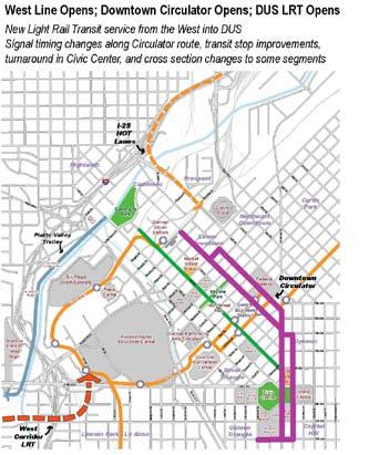
26 The new Circulator Shuttle is needed by 2013 The Streetscape Plan applies throughout Downtown Implementation Plan visions are just that a collective picture of a more desirable future. There are few, if any, circumstances in the complex milieu of cities in which the planning, design, ownership, financing and political resources align to implement a plan s visions and goals quickly and simultaneously. As a result, by necessity, plans are implemented incrementally with the vision and goals providing common direction to the multitude of public and private undertakings. Part of the City process is to evaluate each of these large and small, public and private undertakings in light of the plan s vision and goals, the current situation, and the available resources. Despite this imperfect situation, plans have proven to have substantial influence on the future direction of a plan area over a period of five, 10 or 20 years. Blueprint Denver identifies three categories of implementation strategies: regulatory, infrastructure, and partnerships. The Regulatory category includes ordinances promulgated by City Council and rules and regulations adopted by City agencies. Infrastructure strategies are based on funding through capital improvements and other public and private investment. Partnerships are those areas where city government cannot or should not act unilaterally. Instead, community organizations, businesses or individual citizens partner with government agencies to achieve the goals and recommendations. For DMAP, early action items were identified that follow the above implementation strategies. These action items were categorized by where they fall within the overall implementation process. Construction 1. New Circulator Shuttle All of the FasTracks projects are expected to be complete by the year The timeline on the next page shows the sequence of transit related improvements. Based on ridership forecasts, the new Downtown circulator shuttle must be operational by This infrastructure project will include an exclusive concrete lane on both 18th and 19th Streets, shuttle stop improvements, bus turn-around at 12th Avenue and Acoma Street and Denver Union Station, and acquisition of the buses. The implementation of this project will require a close working relationship between various city departments, affected neighborhoods, and the Regional Transportation District. Design 2. 14th Street Streetscape Design Project There are a number of developments proposed along 14th Street. The Downtown Denver Business Improvement District is supporting the implementation of streetscape related improvements to unify the street. The basis for any recommended improvements should be the DMAP and the companion Streetscape Plan. 26


27 3. Colfax Avenue/12th Street and Colfax Avenue/13th Street Intersection Improvements The Justice Center project has budgeted funds for select improvements to Colfax Avenue. Both intersections should be improved to meet the goals of both the DMAP and the Civic Center District Master Plan. Plans 4. Streetscape Design Guidelines These guidelines will ensure a higher, consistent level of pedestrian environment on all Downtown streets and vibrant pedestrian and transit public spaces, in balance with the vehicular and parking needs. The Streetscape Design Guidelines should be used as a City review document to influence future public and private projects as they are undertaken. This document was developed concurrently with and in the overall context of the DMAP process. 5. Civic Center Station Plan The Civic Center District Plan recommends master planning for the Civic Center Station as an enhanced multimodal connection point. This effort would complement the Denver Union Station Master Plan and define the vision for a secondary transit hub downtown, providing for enhanced connections to the east and the south. 14th Street streetscape improvements will continue as redevelopment progresses A Civic Center Station Plan will incorporate enhanced connections to the east and south Fiscal Note: The early action items listed here are intended to provide priority with respect to the recommendations of this plan. The actual funding amount and timing will be accomplished through the City s capital funding prioritization process, which considers all of the City s capital needs and any external funding sources. 27


28 Downtown Implementation Timeline


29
30
31

32
Cherry Creek Transportation and Land Use Forum September 25, 2013 Meeting Summary
 Cherry Creek Transportation and Land Use Forum September 25, 2013 Meeting Summary I. LEAD-IN TO SMALL GROUP DISCUSSION, POLLING AND STEERING COMMITTEE/TECHNICAL TASK FORCE DISCUSSION The meeting began
PEDESTRIAN ACTION PLAN
 ATTACHMENT 2 CITY OF SANTA MONICA PEDESTRIAN ACTION PLAN CITY OF SANTA MONICA PEDESTRIAN ACTION PLAN This page intentionally left blank EXECUTIVE SUMMARY CHAPTER 1 EXECUTIVE SUMMARY Setting the Stage
Transportation Master Plan Advisory Task Force
 Transportation Master Plan Advisory Task Force Network Alternatives & Phasing Strategy February 2016 BACKGROUND Table of Contents BACKGROUND Purpose & Introduction 2 Linking the TMP to Key Council Approved
CONNECTING PEOPLE TO PLACES
 CONNECTING PEOPLE TO PLACES 82 EAST BENCH MASTER PLAN 07 Introduction The East Bench transportation system is a collection of slow moving, treelined residential streets and major arteries that are the
Executive Summary Route 30 Corridor Master Plan
 Route Corridor Master Plan Project Overview The Route Corridor Master Plan is a coordinated multimodal transportation and land use plan for the entire stretch of Route through East Whiteland Township,
City of Novi Non-Motorized Master Plan 2011 Executive Summary
 City of Novi Non-Motorized Master Plan 2011 Executive Summary Prepared by: February 28, 2011 Why Plan? Encouraging healthy, active lifestyles through pathway and sidewalk connectivity has been a focus
CITY OF COCOA BEACH 2025 COMPREHENSIVE PLAN. Section VIII Mobility Element Goals, Objectives, and Policies
 CITY OF COCOA BEACH 2025 COMPREHENSIVE PLAN Section VIII Mobility Element Goals, Objectives, and Policies Adopted August 6, 2015 by Ordinance No. 1591 VIII MOBILITY ELEMENT Table of Contents Page Number
Downtown Denver Summer 2011 Pedestrian Count Report. Funded by the Downtown Denver Business Improvement District
 Downtown Denver Summer 2011 Pedestrian Count Report Funded by the Downtown Denver Business Improvement District Overview The Downtown Denver Business Improvement District (BID) funds pedestrian counts
Community Task Force July 25, 2017
 Community Task Force July 25, 2017 Welcome and Introductions Project Partners Regional Transportation District (RTD) Colorado Department of Transportation (CDOT) Denver Regional Council of Governments
Exhibit 1 PLANNING COMMISSION AGENDA ITEM
 Exhibit 1 PLANNING COMMISSION AGENDA ITEM Project Name: Grand Junction Circulation Plan Grand Junction Complete Streets Policy Applicant: City of Grand Junction Representative: David Thornton Address:
ACTIVE TRANSPORTATION
 ACTIVE TRANSPORTATION Mobility 2040 Supported Goals Improve the availability of transportation options for people and goods. Support travel efficiency measures and system enhancements targeted at congestion
Agenda. Overview PRINCE GEORGE S PLAZA METRO AREA PEDESTRIAN PLAN
 PRINCE GEORGE S PLAZA METRO AREA PEDESTRIAN PLAN May 28, 2008 Agenda Welcome and introductions Project overview and issue identification Planning context and strengths Design challenges and initial recommendations
Outreach Approach RENEW SF served as the primary liaison with the North Beach community; the Chinatown. Executive Summary
 Executive Summary Executive Summary The Columbus Avenue Neighborhood Transportation Study s objective is to identify changes to transportation infrastructure and policies that could enhance the livability
CITY OF BLOOMINGTON COMPLETE STREETS POLICY
 CITY OF BLOOMINGTON COMPLETE STREETS POLICY POLICY OBJECTIVE: The City of Bloomington will enhance safety, mobility, accessibility and convenience for transportation network users of all ages and abilities,
Corpus Christi Metropolitan Transportation Plan Fiscal Year Introduction:
 Introduction: The Safe, Accountable, Flexible, Efficient Transportation Equity Act: A Legacy for Users (SAFETEA-LU) has continued the efforts started through the Intermodal Surface Transportation Efficiency
5. RUNNINGWAY GUIDELINES
 5. RUNNINGWAY GUIDELINES These guidelines should be considered collectively when making runningway decisions. A runningway is the linear component of the transit system that forms the right-of-way reserved
Chapter 6 Transportation Plan
 Chapter 6 Transportation Plan Transportation Plan Introduction Chapter 6 Transportation Plan Transportation Plan Introduction This chapter describes the components of Arvada s transportation system, comprised
PRINCE GEORGE S PLAZA METRO AREA PEDESTRIAN PLAN
 PRINCE GEORGE S PLAZA METRO AREA PEDESTRIAN PLAN May 28, 2008 Agenda Welcome and introductions Project overview and issue identification Planning context and strengths Design challenges and initial recommendations
WELCOME TO OPEN HOUSE # 1 June 14, 2017
 Langstaff Road Weston Road to Highway 7 Class Environmental Assessment Study WELCOME TO OPEN HOUSE # 1 June 14, 2017 Please sign in and join our mailing list Purpose of Open House #1 & Study Area York
o n - m o t o r i z e d transportation is an overlooked element that can greatly enhance the overall quality of life for the community s residents.
 N o n - m o t o r i z e d transportation is an overlooked element that can greatly enhance the overall quality of life for the community s residents. 84 Transportation CHAPTER 11 INTRODUCTION Transportation
Downtown Denver Summer 2013 Pedestrian Count Report
 Downtown Denver Summer 2013 Pedestrian Report Funded by the Downtown Denver Business Improvement District Downtown Denver Partnership, Inc. Research Department Research Department 511 16 th Street, Suite
C C C
 C-012-001 Thank you for your support for the creation of new public space and nonmotorized access between downtown and the waterfront through the Overlook Walk, the East-West Connections, and the Promenade.
Omaha s Complete Streets Policy
 Omaha s Complete Streets Policy (Adopted August 2015) VISION To create great places and enhance our quality of life, the City of Omaha will provide safe, accessible streets for all users. Complete Streets
Solana Beach Comprehensive Active Transportation Strategy (CATS)
") Solana Beach Comprehensive Active Transportation Strategy (CATS) 3.0 Goals & Policies The Solana Beach CATS goals and objectives outlined below were largely drawn from the Solana Beach Circulation Element
Solana Beach Comprehensive Active Transportation Strategy (CATS) 3.0 Goals & Policies The Solana Beach CATS goals and objectives outlined below were largely drawn from the Solana Beach Circulation Element
Chapter 7. Transportation. Transportation Road Network Plan Transit Cyclists Pedestrians Multi-Use and Equestrian Trails
 Chapter 7 Transportation Transportation Road Network Plan Transit Cyclists Pedestrians Multi-Use and Equestrian Trails 7.1 TRANSPORTATION BACKGROUND The District of Maple Ridge faces a number of unique
Perryville TOD and Greenway Plan
 Perryville TOD and Greenway Plan Greenway Glossary Pathway: A bicycle and pedestrian path separated from motorized vehicular traffic by an open space, barrier or curb. Multi-use paths may be within the
Vision: Traditional hamlet with an attractive business/pedestrian friendly main street connected to adjacent walkable neighborhoods
 N D. Focus Area II Vision: Traditional hamlet with an attractive business/pedestrian friendly main street connected to adjacent walkable neighborhoods Transit Road Focus Area II is located in the Hamlet
Proposed. City of Grand Junction Complete Streets Policy. Exhibit 10
 Proposed City of Grand Junction Complete Streets Policy Exhibit 10 1 City of Grand Junction Complete Streets Policy Vision: The Complete Streets Vision is to develop a safe, efficient, and reliable travel
Circulation in Elk Grove includes: Motor vehicles, including cars and trucks
 Circulation, as it is used in this General Plan, refers to the many ways people and goods move from place to place in Elk Grove and the region. Circulation in Elk Grove includes: Motor vehicles, including
Purpose and Need. Chapter Introduction. 2.2 Project Purpose and Need Project Purpose Project Need
 Chapter 2 Purpose and Need 2.1 Introduction The El Camino Real Bus Rapid Transit (BRT) Project (Project) would make transit and other transportation improvements along a 17.6-mile segment of the El Camino
Bikeway action plan. Bicycle Friendly Community Workshop March 5, 2007 Rochester, MN
 Bikeway action plan Summary The was held on March 5, 2007 at the Rochester Mayo Civic Center. The workshop was hosted by Rochester-Olmsted County Planning Department in collaboration with the League of
Technical Working Group November 15, 2017
 Technical Working Group November 15, 2017 Welcome and Introductions Project Partners Regional Transportation District (RTD) Colorado Department of Transportation (CDOT) Denver Regional Council of Governments
City of Wayzata Comprehensive Plan 2030 Transportation Chapter: Appendix A
 A1. Functional Classification Table A-1 illustrates the Metropolitan Council s detailed criteria established for the functional classification of roadways within the Twin Cities Metropolitan Area. Table
Chapter 5 Future Transportation
 Chapter 5 Future Transportation The Future Land Use Plan identifies the desired land use designations. The land uses desired for Crozet depend, in large part, on the success of the transportation system,
Tonight is for you. Learn everything you can. Share all your ideas.
 Strathcona Neighbourhood Renewal Draft Concept Design Tonight is for you. Learn everything you can. Share all your ideas. What is Neighbourhood Renewal? Creating a design with you for your neighbourhood.
STONY PLAIN ROAD STREETSCAPE
 Jasper Place Revitalization Strategy: Vision The people involved in the Jasper Place Revitalization Strategy envision: Goal 1: Feeling safe in our community Create a community where feeling safe is common--where
Berkeley Strategic Transportation Plan A-76
 Berkeley Strategic Transportation Plan A-76 Appendices 1. A Team Effort 2. Where We ve Been A-11 Berkeley Strategic Transportation Plan Alameda County Transportation Plan Alameda County will be served
Community Task Force November 15, 2017
 Community Task Force November 15, 2017 Welcome and Introductions Project Partners Regional Transportation District (RTD) Colorado Department of Transportation (CDOT) Denver Regional Council of Governments
Public Event 1 Community Workshops
 Public Event 1 Community Workshops Nov. 24 & Dec. 3, 2016 Welcome Workshop Purpose We re looking to you for ideas and insights to help guide future transportation infrastructure planning in the Park Lawn
ROADS, RAILS, AND RUNNING SHOES: DEVELOPING MULTI-MODAL SIGNAL TIMING FOR A NEW LIGHT RAIL CORRIDOR IN AURORA, COLORADO
 Presentation for the ITE Western District Annual Meeting, July 2016, Albuquerque, NM ROADS, RAILS, AND RUNNING SHOES: DEVELOPING MULTI-MODAL SIGNAL TIMING FOR A NEW LIGHT RAIL CORRIDOR IN AURORA, COLORADO
5 Circulation & Parking
 5 Circulation & Parking Downtown Parking & Circulation Strategy. Downtown Wayne has a somewhat disconnected system of local public streets to connect downtown with the residential neighborhoods, and primary
CITY OF VAUGHAN EXTRACT FROM COUNCIL MEETING MINUTES OF OCTOBER 30, 2012
 CITY OF VAUGHAN EXTRACT FROM COUNCIL MEETING MINUTES OF OCTOBER 30, 2012 Item 31, Report No. 39, of the Committee of the Whole, which was adopted without amendment by the Council of the City of Vaughan
City of Hamilton s Transportation Master Plan (TMP) Public Consultation 3 December 2015
 Public Consultation 3 December 2015") City of Hamilton s Transportation Master Plan (TMP) Public Consultation 3 December 2015 McPhail Transportation Planning Services Ltd. AGENDA 6:00 7:00 pm Viewing Boards / Q & A with the Team 7:00 7:50
City of Hamilton s Transportation Master Plan (TMP) Public Consultation 3 December 2015 McPhail Transportation Planning Services Ltd. AGENDA 6:00 7:00 pm Viewing Boards / Q & A with the Team 7:00 7:50
Bicycle Master Plan Goals, Strategies, and Policies
 Bicycle Master Plan Goals, Strategies, and Policies Mobilizing 5 This chapter outlines the overarching goals, action statements, and action items Long Beach will take in order to achieve its vision of
4. ENVIRONMENTAL IMPACT ANALYSIS 9. TRANSPORTATION AND TRAFFIC
 4. ENVIRONMENTAL IMPACT ANALYSIS 9. TRANSPORTATION AND TRAFFIC 4.9.1 INTRODUCTION The following section addresses the Proposed Project s impact on transportation and traffic based on the Traffic Study
MAG Town of Cave Creek Bike Study Task 6 Executive Summary and Regional Significance Report
 Page 1 MAG Town of Cave Creek Bike Study Task 6 Executive Summary and Regional Significance Report August 1, 2012 MAG Project #481 Page 2 Task 6 Executive Summary and Regional Significance Report Introduction
2. Context. Existing framework. The context. The challenge. Transport Strategy
 Transport Strategy Providing quality connections Contents 1. Introduction 2. Context 3. Long-term direction 4. Three-year priorities 5. Strategy tree Wellington City Council July 2006 1. Introduction Wellington
Route 7 Corridor Study
 Route 7 Corridor Study Executive Summary Study Area The following report analyzes a segment of the Virginia State Route 7 corridor. The corridor study area, spanning over 5 miles in length, is a multi
Living Streets Policy
 Living Streets Policy Introduction Living streets balance the needs of motorists, bicyclists, pedestrians and transit riders in ways that promote safety and convenience, enhance community identity, create
Chapter 2. Bellingham Bicycle Master Plan Chapter 2: Policies and Actions
 Chapter 2 Bellingham Bicycle Master Plan Chapter 2: Policies and Actions Chapter 2: Policies and Actions The Bicycle Master Plan provides a road map for making bicycling in Bellingham a viable transportation
Moving Cambridge. City of Cambridge Transportation Master Plan Public Consultation Centre. March 7, :00 8:00 PM.
 City of Cambridge Transportation Master Plan Public Consultation Centre March 7, 2018 5:00 8:00 PM Region of Waterloo City of Cambridge Transportation Master Plan Public Consultation Centre March 7, 2018
Ann Arbor Downtown Street Plan
 1 Ann Arbor Downtown Street Plan Public Workshop #1 We know that. 2 Public right-of-way (streets, sidewalks, and alleys) make up 30% of the total District area of downtown. Streets need to provide mobility
Chapter VISION, MISSION, AND GOALS AND OBJECTIVES. Vision. Mission. Goals and Objectives CONNECTING COMMUNITIES ACROSS THE ST.
 VISION, MISSION, AND GOALS AND OBJECTIVES Chapter 3 The Plan s vision, mission, and goals and objectives were developed through a series of interactive exercises with the Citizens Advisory Committee (CAC)
Sixth Line Development - Transit Facilities Plan
 Memorandum Date: November 13, 2012 To: From: c.c. Subject: Rob Freeman (Freeman Planning) Kevin Phillips Sixth Line Development - Transit Facilities Plan 33016631 This memo was prepared to review the transit
5 CIRCULATION AND STREET DESIGN
 5 CIRCULATION AND STREET DESIGN This chapter describes circulation and streetscape improvements proposed for the Northwest Chico Specific Plan Area. It includes detailed design specifications for existing
Bus Rapid Transit Plans
 Twin Cities Region Bus Rapid Transit Plans ULI Minnesota Workshop Connecting Bus Rapid Transit to the Community December 15, 2009 John Levin Director of Service Development Metro Transit Metropolitan Area
North Coast Corridor:
 North Coast Corridor: Connecting People, Transportation & Environment Legislative Hearing: 11.8.10 1 North Coast Corridor Region s Lifeline A Regional Strategy Mobility, Economy & Environment North Coast
APPENDIX A: Complete Streets Checklist DRAFT NOVEMBER 2016
 APPENDIX A: Complete Streets Checklist DRAFT NOVEMBER 2016 Complete Streets Checklist MetroPlan Orlando s Complete Streets Checklist is an internal planning tool for staff to further implementation of
NM-POLICY 1: Improve service levels, participation, and options for non-motorized transportation modes throughout the County.
 Transportation PRINCE WILLIAM COUNTY 2008 COMPREHENSIVE PLAN NON-MOTORIZED PLAN CONTENTS Goals, Policies, and Action Strategies Table 4 (Bike Facility Classifications and Descriptions) Table 5 (Bike Facility
Regional Transportation Needs Within Southeastern Wisconsin
 Regional Transportation Needs Within Southeastern Wisconsin #118274 May 24, 2006 1 Introduction The Southeastern Wisconsin Regional Planning Commission (SEWRPC) is the official areawide planning agency
Access BART: TOD and Improved Connections. October 29, 2008
 Access BART: TOD and Improved Connections October 29, 2008 1 Access BART Study Goals Evaluate at the system-level land use and access scenarios to optimize ridership Identify station clusters that provide
This page intentionally left blank.
 This page intentionally left blank. COMMUNITY Glenpool Community Overview Glenpool Glenpool is a city of nearly 12,000 residents located in Tulsa County southwest of Tulsa and Jenks. The city is growing
S T A T I O N A R E A P L A N
 The Circulation and Access Plan describes vehicle, pedestrian, and transit improvements recommended within the Concept Plan. In order to create and sustain a vibrant business district that provides pedestrian-friendly
Community Task Force March 14, 2018
 Community Task Force March 14, 2018 Welcome and Introductions Project Partners Regional Transportation District (RTD) City of Aurora Colorado Department of Transportation (CDOT) Denver Regional Council
ACTIVE TRANSPORTATION/NONMOTORIZED TRANSPORTATION
 ACTIVE TRANSPORTATION/NONMOTORIZED TRANSPORTATION BACKGROUND Active transportation, also known as nonmotorized transportation, is increasingly recognized as an important consideration when planning and
Goodlettsville Bicycle and Pedestrian Plan Executive Summary
 Goodlettsville Bicycle and Pedestrian Plan July 2010 In Cooperation with the Nashville Area Metropolitan Planning Executive Organization Summary Introduction Progressive and forward thinking communities
Welcome. Background. Goals. Vision
 Welcome The formal Public Information Centre (PIC) for the Transportation Master Plan How We GO will be held in early 2017. At that time we will present the recommended transportation system for Niagara
University of Victoria Campus Cycling Plan Terms of Reference. 1.0 Project Description
 University of Victoria Campus Cycling Plan Terms of Reference 1.0 Project Description The Campus Cycling Plan, a first for the University, will provide a comprehensive and coordinated approach to support
MCTC 2018 RTP SCS and Madera County RIFP Multi-Modal Project Eval Criteria GV13.xlsx
 MCTC 8 RTP SCS and Madera County RIFP Multi-Modal Project Eval Criteria GV.xlsx Madera County Transportation Commission Regional Transportation Plan / Sustainable Communities Strategy Multi-Modal Project
APPENDIX 2 LAKESHORE ROAD TRANSPORTATION REVIEW STUDY EXECUTIVE SUMMARY
 APPENDIX 2 LAKESHORE ROAD TRANSPORTATION REVIEW STUDY EXECUTIVE SUMMARY Appendix 2 City of Mississauga Lakeshore Road FINAL REPORT Transportation Review Study December 2010 EXECUTIVE SUMMARY Study Purpose
Welcome! Public Open House on UBC s Transportation Plan
 1 Welcome! Public Open House on UBC s Transportation Plan Public open house hours: to When it comes to on-campus transportation, what do you think is working well and what are some opportunities for improvement?
West Dimond Blvd Upgrade Jodhpur Street to Sand Lake Road
 West Dimond Blvd Jodhpur St to Sand Lake CSS Transportation Project Summary Municipality of Anchorage Project # 05 005 Project Manager: John Smith, P.E. (MOA PM&E) Project Administrator: Julie Makela,
Develop a Multi-Modal Transportation Strategy (Theme 6)
") DEVELOP A MULTI-MODAL TRANSPORTATION STRATEGY (THEME 6) WHY IS THIS THEME ADDRESSED? Develop a Multi-Modal Transportation Strategy (Theme 6) Statement of Ideal Reduce resident and visitor reliance on single
DEVELOP A MULTI-MODAL TRANSPORTATION STRATEGY (THEME 6) WHY IS THIS THEME ADDRESSED? Develop a Multi-Modal Transportation Strategy (Theme 6) Statement of Ideal Reduce resident and visitor reliance on single
Active Transportation Facility Glossary
 Active Transportation Facility Glossary This document defines different active transportation facilities and suggests appropriate corridor types. Click on a facility type to jump to its definition. Bike
Transportation. Our Parker community. will develop and sustain. a safe, convenient and. efficient transportation. system incorporating
 VISION Our Parker community will develop and sustain a safe, convenient and efficient transportation system incorporating and integrating various modes of travel including automobiles, public transportation,
Clackamas County Comprehensive Plan
 ROADWAYS The County s road system permits the movement of goods and people between communities and regions, using any of a variety of modes of travel. Roads provide access to virtually all property. They
Transportation Assessment
 Transportation Assessment Midtown Open House February 10, 2018 Overview Midtown in Focus Overview & Purpose of Today Transportation Assessment overview Summary of Transportation work to date Review & Analysis
2025 Comprehensive Plan for the City of Temple Terrace Florida. Mobility Element. Adopted by City Council June 30, 2009
 2025 Comprehensive Plan for the City of Temple Terrace Florida Mobility Element Adopted by City Council June 30, 2009 Effective Date September 22, 2009 GOAL 2: To protect and promote the quality of life
Providence Downtown Transit Connector STAKEHOLDER MEETING #2. Stakeholder Meeting #1 October 24, 2016
 Providence Downtown Transit Connector STAKEHOLDER MEETING #2 Stakeholder Meeting #1 October 24, 2016 February 2017 1 AGENDA 1 DTC Goals and Expectations 2 Street Design Concepts 3 Potential Benefits and
INTRODUCTION THOROUGHFARE SYSTEM CLASSIFICATIONS
 INTRODUCTION The thoroughfare plan will assist public officials in the development of a specialized system for efficient and safe movement of vehicular traffic while minimizing potential conflicts with
Los Altos Hills Town Council - June 18, 2015 Palo Alto City Council June 22, AGENDA ITEM #2.B Presentation
 Los Altos Hills Town Council - June 18, 2015 Palo Alto City Council June 22, 2015 AGENDA ITEM #2.B Presentation Previous Presentations Los Altos Hills Town Council in May 2014 and February 2015 Palo Alto
Multimodal Through Corridors and Placemaking Corridors
 68 Multimodal Through Corridors and Placemaking Corridors Corridors have different functions in a region. Some corridors are used to get smoothly and rapidly through a region or to get quickly to major
Summary: Mercer County Princeton Avenue & Spruce Street Study January 2009
 Summary: Several recent studies have assessed potential development and redevelopment opportunities in the Mercer Crossing area of Trenton, Ewing, and Lawrence. This Princeton Avenue and Spruce Street
Preliminary Transportation Analysis
 Preliminary Transportation Analysis Goals of a Robust, Multimodal Transportation Network Safe Accessible/Connected Efficient Comfortable Context-Sensitive Motor Vehicle: Continue to analyze the data to
SANTA CLARA COUNTYWIDE BICYCLE PLAN August 2008
 SANTA CLARA COUNTYWIDE BICYCLE PLAN August 2008 To assist VTA and Member Agencies in the planning, development and programming of bicycle improvements in Santa Clara County. Vision Statement To establish,
DRAFT BUENA VISTA 2020 TRANSPORTATION PLAN
 DRAFT BUENA VISTA 2020 TRANSPORTATION PLAN DEVELOPED BY THE TRANSPORTATION PLANNING DIVISION OF THE VIRGINIA DEPARTMENT OF TRANSPORTATION IN COOPERATION WITH THE U.S. DEPARTMENT OF TRANSPORTATION, FEDERAL
4 MOBILITY PLAN. Mobility Plan Objectives. Mobility Context. 1. Integrate with Local and Regional Transit Improvements
 Harbor Mixed Use CHAPTER Transit Corridor 4: Mobility Plan 4 MOBILITY PLAN Mobility Plan Objectives The Harbor Corridor Plan seeks to expand and improve the ways that people move along and through the
Complete Street Analysis of a Road Diet: Orange Grove Boulevard, Pasadena, CA
 Complete Street Analysis of a Road Diet: Orange Grove Boulevard, Pasadena, CA Aaron Elias, Bill Cisco Abstract As part of evaluating the feasibility of a road diet on Orange Grove Boulevard in Pasadena,
4.0 TRANSPORTATION SYSTEMS
 Transportation Systems 4.0 TRANSPORTATION SYSTEMS This chapter examines the impacts of the Central Corridor Extension on existing roadways and traffic operations and discusses the transit service, operations,
Appendix A-2: Screen 1 Alternatives Report
 Appendix A-2: Screen 1 Alternatives Report SCREEN 1 ALTERNATIVES REPORT Western & Ashland Corridors Bus Rapid Transit (BRT) Project Prepared for Chicago Transit Authority 567 West Lake Street Chicago,
York Region Population and Employment Growth
 March 1, 2016 1 York Region Population and Employment Growth York Region needs to comply with The Provincial Growth Plan and new forecasts introduced to 2036 and 2041 2 Regional Official Plan Review York
Physical Implications of Complete Streets Policies
 Presentation Overview Physical Implications of Complete Norm Cox, ASLA, LLA Landscape Architect Ann Arbor, Michigan, 10:45 to Noon What Are Complete Streets? What Matters to Bicyclists and Pedestrians
This page intentionally left blank.
 This page intentionally left blank. COMMUNITY Coweta Community Overview Coweta Coweta, a residential community located in Wagoner County, is a suburb of Tulsa situated southeast of the metropolitan area
3.0 Future Conditions
 3.0 Future Conditions In order to be able to recommend appropriate improvements to the transportation system of the Town, it is important to first understand the nature and volume of traffic that is expected
Table #6 VISION CHARACTERISTICS
 Table #6 VISION White Flint is a place to live, work, play, shop, and walk with sufficient density to encourage quality redevelopment. Vibrant streets and consistent streetscapes are important. CHARACTERISTICS
Chapter 3: Multi-Modal Circulation and Streetscapes
 CHAPTER 3: MULTI-MODAL CIRCULATION AND STREETSCAPES Chapter 3: Multi-Modal Circulation and Streetscapes Overview Streetscape improvements have already been completed for Depot Street between Main Avenue
University Hill Transportation Study Technical Memorandum Alternatives Modeling and Analysis May 2007
 Technical Memorandum May 2007 Syracuse Metropolitan Transportation Council Edwards and Kelcey with Wallace Roberts and Todd Alta Planning and Design CONTENTS SECTION ONE- INTRODUCTION...1 SECTION TWO-
San Jose Transportation Policy
 San Jose Transportation Policy Protected Intersections in LOS Policies to Support Smart Growth Presented by: Manuel Pineda City of San Jose Department of Transportation Bay Area Map San Francisco Oakland
Classification Criteria
 SCHEDULE D TO RECOMMENDED OFFICIAL PLAN AMENDMENT NO. 40 SCHEDULE C-4 Road Criteria Criteria Traffic Service Objective Land Service/Access Typical Daily Traffic Volume Flow characteristics Travel Speed
FROM: CITY MANAGER DEPARTMENT: PLANNING AND COMMUNITY ENVIRONMENT DATE: OCTOBER 4, 2004 CMR:432:04
 TO: HONORABLE CITY COUNCIL FROM: CITY MANAGER DEPARTMENT: PLANNING AND COMMUNITY ENVIRONMENT DATE: OCTOBER 4, 2004 CMR:432:04 SUBJECT: FINANCE COMMITTEE RECOMMENDATION TO ADOPT TRANSPORTATION STRATEGIC