ETTER STREETS PLAN FINAL PLAN ADOPTED BY THE SAN FRANCISCO BOARD OF SUPERVISORS ON DECEMBER 7, Mayor s Office on Disability SAN FRANCISCO
|
|
|
- Benedict Rogers
- 5 years ago
- Views:
Transcription


1 SAN FRANCISCO ETTER STREETS PLAN OLICIES AND GUIDELINES FOR THE PEDESTRIAN REALM SAN FRANCISCO PLANNING DEPARTMENT Mayor s Office on Disability FINAL PLAN ADOPTED BY THE SAN FRANCISCO BOARD OF SUPERVISORS ON DECEMBER 7, 2010

2 Cover rendering by Allan B. Jacobs The BETTER STREETS PLAN is intended to illustrate best practices and provide a guiding document for all actors wishing to make changes to the public right-of-way in San Francisco. The BETTER STREETS PLAN is explicitly intended as guidance only, as opposed to definitive standards. The BETTER STREETS PLAN describes and illustrates typical situations for the design of streets, sidewalks, and intersections, based on typical street types and standard street improvements. Intersection geometry, topography, transportation factors, and other existing conditions combine create many unique situations. The BETTER STREETS PLAN provides flexibility for the professional to design to specific conditions. To the greatest extent feasible, the guidelines contained in this document should be followed to create a pedestrian environment that serves all users.

3
4 Contact For more information on the Better Strees Plan, contact: Adam Varat, Project Manager San Francisco Planning Department Visit our website at:


5 SAN FRANCISCO BETTER STREETS PLAN POLICIES AND GUIDELINES FOR THE PEDESTRIAN REALM FINAL PLAN ADOPTED BY THE SAN FRANCISCO BOARD OF SUPERVISORS ON DECEMBER 7, 2010
6 Read this first: Navigating the Better Streets Plan The Better Streets Plan guides the design of the pedestrian environment for all users. It s a long document, but most of the time users will only need to read certain portions. This page will help you quickly figure out where to look in the document for particular guidance. USERS The Better Streets Plan is intended for a variety of users, including: Decision-makers: The Plan recommends policy directions and next steps to achieve a great pedestrian environment. See Chapter 3. Street designers and managers: The Plan sets guidelines to guide the design and use of the pedestrian environment, whether new streets, full streetscape re-designs, or design and placement of individual streetscape elements. See Chapters 4, 5, and 6. Stakeholders: The plan provides a resource and guide for community members, organizations, or private developers making streetscape improvements or seeking to understand the rules regarding design and use of the pedestrian environment. See Chapters 4, 5, and 6. DOCUMENT STRUCTURE The Better Streets Plan consists of the following sections: 1. Introduction Background, overview of the plan process, and next steps. 2. Context Existing pedestrian and streestcape conditions, relevant federal, state, and local policies, and existing City planning efforts relating to street design. 3. Goals and Policies: The Path to Better Streets Plan goals, objectives, and policy directions to achieve Better Streets. 4. Approach: Designing Great Streetscapes Framework for design of the pedestrian realm by street type, and guidelines that apply to the pedestrian environment as a whole, such as sidewalk zones and general layout of streetscape elements. 5. Guide: Street Designs Guidelines for curb lines and related features, such as medians, curb extensions, and crosswalks. 6. Guide: Streetscape Elements Guidelines for individual streetscape elements, such as plantings, lighting, site furnishings, and utilities. 7. Implementation Recommendations for implementing Better Streets, including maintenance, enforcement, and funding strategies. Designing a street? Follow these steps: 1. Determine street type (See Section 4.1) 2. Identify appropriate standard and additional elements for that street type (4.1) 3. See guidelines for overall design: sidewalk width, sidewalk zones, and layout of streetscape elements (4.2) 4. Follow specific guidelines for individual elements as necessary (Chapters 5 and 6) Locating a specific element? Follow these steps: 1. See guidelines for overall design: sidewalk width, sidewalk zones, and layout of streetscape elements (Chapter 4) 2. Follow specific guidelines for the particular element (Chapters 5 and 6)
7 Contents 1.0 EXECUTIVE SUMMARY INTRODUCTION BACKGROUND PLAN DEVELOPMENT MOVING FORWARD 15 III 5.0 GUIDE: STREET DESIGNS CROSSWALKS AND PEDESTRIAN SIGNALS CORNER CURB RADII CURB EXTENSIONS (BULB-OUTS) MEDIANS AND ISLANDS TRANSIT-SUPPORTIVE STREETSCAPE DESIGN PARKING LANE TREATMENTS TRAFFIC CALMING AND ROUNDABOUTS PEDESTRIAN-PRIORITY DESIGNS CONTEXT EXISTING CONDITIONS REGULATORY CONTEXT EXISTING CITY EFFORTS 29 GOALS AND POLICIES: THE PATH TO BETTER STREETS VISION PREFACE TO GOALS AND POLICIES GOALS AND POLICIES GUIDE: STREETSCAPE ELEMENTS URBAN FOREST STORMWATER MANAGEMENT TOOLS LIGHTING PAVING SITE FURNISHINGS UTILITIES AND DRIVEWAYS 233 IMPLEMENTATION APPROACH: DESIGNING GREAT STREETSCAPES STREET TYPES OVERALL STREETSCAPE GUIDELINES 60 AP APPENDICES 234 A BETTER STREETS POLICY 251 B TRANSIT-FIRST POLICY 252 C COMPLETE STREETS POLICY 254 D SUMMARY OF COMMUNITY INVOLVEMENT 255 E SUMMARY OF ACCESSIBILITY GUIDELINES 256 F GLOSSARY 263 G SUMMARY OF PHYSICAL ELEMENTS IN THE BETTER STREETS PLAN 266


8 Streets are almost always public: owned by the public, and when we speak of the public realm we are speaking in large measure of streets. What is more, streets change. They are tinkered with constantly: curbs are changed to make sidewalks narrower or (in fewer cases) wider, they are repaved, lights are changed, the streets are torn up to replace water and sewer lines or cables and again repaved. The buildings along them change and in doing so change the streets. Every change brings with it the opportunity for improvement. If we can develop and design streets so that they are wonderful, fulfilling places to be, community-building places, attractive public places for all people of cities and neighborhoods, then we will have successfully designed about one-third of the city directly and will have had an immense impact on the rest. Allan Jacobs, Great Streets, MIT Press, 1995


9 Executive Summary INTRODUCTION PLAN HIGHLIGHTS Rendering by Allan B. Jacobs The Better Streets Plan provides a blueprint for the future of San Francisco s pedestrian environment. It describes a vision, creates design guidelines, and identifies next steps to create a truly great pedestrian realm. The Plan seeks to balance the needs of all street users, and reflects the understanding that the pedestrian environment is about much more than just transportation that streets serve a multitude of social, recreational and ecological needs that must be considered when deciding on the most appropriate design. The Plan follows from the Better Streets Policy, adopted by the Board of Supervisors and the Mayor in February 2006, which describes the varied roles that the City s streets should play. The Better Streets Plan provides guidelines for the pedestrian environment, defined as the areas of the street where people walk, shop, sit, play, or interact outside of moving vehicles. Generally speaking, this refers to sidewalks and crosswalks; however, in some cases, this may be expanded to include certain areas of the roadway. The Plan does not generally focus on roadway or vehicle travel characteristics. If fully realized, the Better Streets Plan will bring a number of benefits to San Francisco. It will help retain families in San Francisco, support Muni and a transit-first city, help promote public safety, help to minimize sewer/stormwater overflows into the Bay, decrease the likelihood of pedestrian injuries and fatalities, increase accessibility for all street users, and enhance the everyday quality of life for San Francisco s residents. This plan follows from a long public and technical process. City staff attended over 100 community meetings relating to the Better Streets Plan, held monthly meetings with a Community Advisory Committee, and received over 1,000 responses to the two Better Streets Plan surveys. As well, the Better Streets team has met with technical agency staff to gather comments regarding technical feasibility of initial concepts and proposals. The Better Streets Plan contains a wide range of guidelines relating to streetscape and pedestrian facilities. Major themes and ideas include: Distinctive, unified streetscape design: Street trees as defining the streetscape rhythm; integrated site furnishings; regular pedestrian-oriented lighting; minimizing cluttering elements. Space for public life: Safe, useable public seating for neighborhood gathering; generous curb extensions for seating and landscaping; reclaiming of excess street space for public use; space for outdoor café and restaurant seating and merchant displays. Enhanced pedestrian safety: Safe, convenient pedestrian crossings; curb radii and curb extensions that slow traffic, shorten crossing distance, and enhance visibility; pedestrian countdown signals and other pedestrian priority signals (head-start, pedestrian scramble). Improved street ecology: On-site stormwater management to reduce combined sewer overflows; resource-efficient elements and materials; streets as green corridors and habitat connectors. Universal design and accessibility: Generous, unobstructed sidewalks, curb ramps for all users, accessible pedestrian signals. Integrating pedestrians with transit: Transit rider amenities at key stops; safe, convenient pedestrian routes to transit; mutual features that benefit pedestrian safety and comfort and transit operations, such as bus bulb-outs and boarding islands. Creative use of parking lanes: Permanent curb extensions with seating and landscaping; landscape planters in the parking lane; flexible, temporary use of the parking lane for restaurant seating or other uses. Traffic calming to reduce speeding and enhance pedestrian safety: Raised crossings and speed tables; landscaped traffic circles; chicanes. EXECUTIVE SUMMARY B E T T E R S T R E E T S P L A N i
10 EXECUTIVE SUMMARY EXECUTIVE SUMMARY Pedestrian-priority designs: Shared public ways; temporary or permanent street closures to vehicles; sidewalk and median pocket parks. Extensive greening: Healthy, well-maintained urban forest; expanded sidewalk plantings; efficient utility location to provide more potential planting locations. NEXT STEPS In order to implement the vision of the plan, the City must take a variety of next steps, including the following: Improve the coordination and delivery of street improvements. Create an easy to use Better Streets guide and website. Develop a framework for implementation and prioritization of street improvement projects. 2.1 Existing conditions Walking accounts for 20% of all trips made in San Francisco 1. Major activity generators include transit hubs, schools, hospitals and shopping centers. Pedestrian volumes are highest in the northeast quadrant of the city, and along major transit corridors. Pedestrian collisions and fatalities have been generally declining over time, though still remain significant. Many pedestrian collisions are concentrated in a few areas of the city. The Better Streets Plan is a vision for the future of the City s pedestrian environment. These suggested improvements are not extravagant or uncommon they are in use in many cities across the state and nation. However, even typical street improvements cost money to build and maintain. To build out the Plan s recommendations on the City s streets, the City must have capital and maintenance funding in place funding the City does not currently have. The City must continue to seek funding to realize the vision of the Better Streets Plan. Better streets rely on successful implementation ongoing capital funding, efficient maintenance, and effective education and enforcement. This plan describes a vision for ideal streets, and recognizes the need to have detailed implementation strategies. The plan identifies high-level implementation measures. Other recommendations have been developed in an accompanying report by the Controller s Office. The Better Streets Plan is merely the first step to realizing an improved pedestrian environment and public realm in San Francisco. It sets high-level guidelines that should be used in the City s on-going streetscape and pedestrian design. It does not seek to prioritize or create a project list of Better Streets projects. Nor does it give specific engineering guidance on a number of technical topics those standards may be found in other existing or planned documents. Develop additional technical guidance on a number of topics, including: urban forest, stormwater, street and pedestrian lighting, street furnishing, and roadway design guidelines. CHAPTERS The Better Streets Plan consists of the following chapters: 1. Introduction 2. Context 3. Goals and Policies: The Path to Better Streets 4. Approach: Designing Great Streetscapes 5. Guide: Street Designs 6. Guide: Streetscape Elements 7. Implementation 1.0 INTRODUCTION Chapter 1 gives background on the plan, describes the plan development, and identifies next steps, and is summarized above. 2.0 CONTEXT Chapter 2 describes existing conditions and policies relating to streets and the pedestrian environment in San Francisco today. Streetscape and pedestrian infrastructure includes signs and signals, sidewalks, curb ramps, street trees, street lighting, site furnishings, and stormwater infrastructure. San Francisco s street and sidewalk infrastructure varies greatly, as does data on the condition of these features. The City is engaged in collecting on-going data on a number of features. 2.2 Existing policies Street design in San Francisco is subject to federal, state, and local policies, standards, and guidelines. Key federal and state policies and standards include the Americans with Disabilities Act (ADA) and related documents, the California Manual on Uniform Traffic Control Devices (MUTCD), the California Vehicle Code (CVC), American Association of State Highway and Transportation Officials (AASHTO) standards, the California Environmental Quality Act (CEQA), and the Clean Water Act and National Pollutant Discharge Elimination System (NPDES) permit, which regulates stormwater runoff into receiving waters. Locally, San Francisco has passed the Transit-First Policy (City Charter Section ) and the Better Streets Policy (Administrative Code Chapter 98), which prioritize street improvements that enhance transit trips over other transportation modes, and require the City to coordinate to create streets that are pedestrian-oriented and multifunctional, respectively. Additional City policies can be found in the San Francisco General Plan and its constituent elements. The Countywide Transportation Plan also 1 San Francisco County Transportation Authority ii B E T T E R S T R E E T S P L A N
11 guides street improvements. City standards and guidelines relating to street design can be found in the Administrative Code, Building Code, Fire Code, Planning Code, Public Works Code, Transportation Code, and in departmental orders, design guidelines, and standard plans. 2.3 Existing City efforts The City has a number of on-going projects and programs relating to street improvement. Responsibility for street planning, design, funding, regulation, maintenance, education, and enforcement is spread over several departments. Though there are many good projects, there is often inconsistency in the results, and the process can be expensive, time-consuming, and confusing. 3.0 GOALS AND POLICIES: THE PATH TO BETTER STREETS Chapter 3 describes an overall vision for better streets. It describes goals, objectives, policies, guidelines, and next steps to achieve a great pedestrian environment, based on the following 10 Elements of Better Streets. 5. Promote healthy lifestyles: San Francisco s streets should promote healthy lifestyles by encouraging walking to daily and occasional destinations, minimizing pedestrian injuries and helping to decrease major chronic diseases related to air quality and pedestrian activity. 6. Safe: San Francisco s streets should be designed to create a street environment that supports a high level of pedestrian safety and security. 7. Create convenient connections: San Francisco s streets should be designed to facilitate safe, accessible, and convenient connections among major nodes, hubs, destinations, transit centers, and major land use and activity centers. 8. Ecologically sustainable: San Francisco s streets should be designed as a green network, enhancing the City s long-term ecological functioning. 9. Accessible: San Francisco streets should be designed for ease of use and access to destinations for all populations, particularly those with visual or mobility impairments. industrial, mixed-use) and transportation roles (downtown, throughway, neighborhood). Special streets (parkways, park edge streets, boulevards and ceremonial (civic) streets), and small streets (alleys, shared public ways, and pedestrianonly streets) are called out separately. These classifications are not intended to replace technical transportation classifications, but to help make decisions about streetscape design. Section 4.1 shows a typical site plan and section for each street type, using recommended sidewalk widths, pedestrian facilities, and streetscape amenities. For each street type, the Plan lists standard improvements (such as street trees, curb ramps, marked crossings, and site furnishings) and case-by-case additions (such as mid-block crosswalks, landscaped center medians, perpendicular or angled parking with corner plazas, and extended bulb-outs with landscaping and seating). Standard additions should generally be included in any streetscape design project on a particular street type. Case-by-case additions should be considered as budgets, physical conditions, and neighborhood preferences allow. EXECUTIVE SUMMARY Streets should (be): 1. Memorable: San Francisco s streets should be designed to give the city and its neighborhoods a recognizable image and provide a means of orientation and understanding of the city. 2. Support diverse public life: San Francisco s streets should provide opportunities for diverse experiences and encourage people to spend time engaging in social and recreational activities. 3. Vibrant places for commerce: San Francisco s streets should be designed and managed as attractive and exciting destinations that encourage residents and visitors to walk to and use local shopping areas, rather than to drive to regional shopping centers. 4. Promote human use and comfort: San Francisco streets should be designed to prioritize the everyday needs of people and to support human comfort and enjoyment. 10. Attractive, inviting, and well-cared for: San Francisco s streets should be beautiful, create an engaging visual impression, appeal to senses of sight, smell, and sound, and encourage a sense of ownership and civic pride that is reflected in streets physical appearance and level of activity. 4.0 APPROACH: DESIGNING GREAT STREETSCAPES Chapter 4 sets a framework for overall streetscape design. It is divided into two sections: 4.1 Street Types; and 4.2 Overall Streetscape Guidelines. 4.1 Street Types Different streets play different roles, so this chapter begins by categorizing streets into different street types for the purposes of streetscape design. Street classifications are based on land use characteristics (residential, commercial, 4.2 Overall Streetscape Guidelines Section 4.2 provides overall guidelines for the streetscape environment. Streetscapes should be designed to encompass a variety of features and amenities, and reflect a unified design sensibility. Streetscape projects should be combined wherever possible to provide completeness in streetscape design. For example, curb ramp projects may be combined with building curb extensions, which could house seating, landscaping, and stormwater treatment measures. Section 4.2 describes appropriate elements and treatments for intersection design, including marked crosswalks, curb ramps, parking restrictions at corners, tight turn radii, curb extensions, pedestrian refuge islands, street trees, street and pedestrian lighting, and site furnishings. These elements should be combined to create a safe, convenient, inviting intersection for pedestrians. B E T T E R S T R E E T S P L A N iii
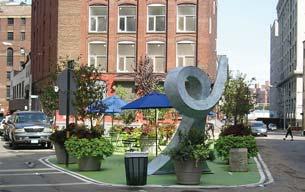
12 EXECUTIVE SUMMARY EXECUTIVE SUMMARY Next, Section 4.2 discusses sidewalk widths and zones. Sidewalks are divided into five zones: frontage, throughway, furnishings, edge, and extension. These terms are used throughout the document. Minimum and recommended sidewalk widths are given for each street type. Sidewalks below minimum width should be considered deficient, and should be widened as opportunities and funding allow. Recommended widths are wide enough to allow for desired streetscape amenities. Sidewalks on new streets should meet or exceed recommended widths. 5.2 Corner curb radii Corner curb radii (turn radii) have a major impact on pedestrian safety and quality. Tight turn radii slow turning vehicles, shorten crossing distances and enhance visibility. Turn radii should be as tight as possible to enhance pedestrian comfort; however, they should be designed to accommodate turning vehicles as well per the guidelines. This section also presents alternative strategies for dealing with intersections with frequent large turning vehicles. 5.6 Parking lane treatments In many cases, the pedestrian environment may be extended into the parking lane, either permanently or temporarily. Curb extensions are one way of achieving this. Providing perpendicular or angled parking where roadway width allows can also allow for the creation of significant corner plazas. Alternative uses for the parking lane are also considered, including landscaped planters, bicycle parking, and flexible (temporary) use of the parking lane for outdoor seating. Finally, this section describes guidelines for overall layout of streetscape elements. Streetscapes should wisely allocate limited space, strive for wholeness, and accommodate pedestrian needs. Street trees should define the rhythm of the streetscape, and be the primary organizing element. Conflicts with ideal street tree locations should be minimized to achieve this rhythm. Street and pedestrian lighting may be placed in an off-setting rhythm. Other site furnishings should be placed in relation to these elements, per appropriate clearances, discussed in Chapter GUIDE: STREET DESIGNS Chapter 5 describes guidelines for street designs such as curb geometries, crosswalks, parking lanes, and special street conditions. It is divided into eight sections: 5.1 Crosswalks and Pedestrian Signals; 5.2 Corner curb radii; 5.3 Curb extensions; 5.4 Medians and Islands; 5.5 Transit-Supportive Streetscape Design; 5.6 Parking lane treatments; 5.7 Traffic calming and roundabouts; and 5.8 Pedestrian-priority designs. 5.1 Crosswalks and Pedestrian Signals Crosswalks are an essential part of a safe, convenient pedestrian realm, and may also be an urban design treatment. This section describes guidelines for location and design of marked crosswalks at intersections and mid-block locations, special treatments such as raised crossings, special paving treatments, and special signals, pedestrian signals, and vehicle movements at intersections, including right turns on red and multiple turn lanes. 5.3 Curb extensions Similar to curb radii, curb extensions slow turning vehicles, shorten crossing distances and enhance visibility by extending the sidewalk into parking lanes. Corner curb extensions should be a standard treatment on most street types. They should be designed to maximize pedestrian space. Generous curb extensions may allow opportunities for landscaping, seating, and stormwater management. They may also be placed at mid-block locations to create a small plaza. 5.4 Medians and islands Medians are continuous raised areas within the roadway that control traffic, and may have a traffic calming, greening, and ecological benefit. They may also provide pedestrian refuges at crossings. Medians should include trees and other landscaping as appropriate. Islands are smaller raised areas within the roadway. They may provide a pedestrian refuge, traffic calming, or design feature. 5.5 Transit-Supportive Streetscape Design Most transit rides begin or end on foot. People waiting at transit stops are some of the most frequent users of the pedestrian realm. Transit waiting areas should be designed with amenities for waiting riders. They must also be accessible to all users and provide clear paths to and from the transit shelter and vehicle. Bus bulbs and transit boarding islands may be used to improve transit operations and also provide greater sidewalk space. 5.7 Traffic calming and roundabouts Traffic calming enhances pedestrian safety and neighborhood character by slowing traffic. Traffic calming measures discussed in this plan include traffic circles and chicanes. These should be designed to slow traffic by visually narrowing the street and forcing cars to shift laterally. They may also present opportunities for landscaping, stormwater treatment, and community stewardship. Roundabouts are traffic control devices with limited applicability in San Francisco. Where they are used, consideration should be given to pedestrian safety, accessibility, and wayfinding. 5.8 Pedestrian-priority designs Pedestrian-priority designs are special cases that provide more than the standard sidewalk space for pedestrians. These include: sidewalk and median pocket parks, shared public ways, local lanes and medians on multi-way boulevards, pedestrian-only streets, and public stairs. In all cases, the pedestrian area or shared pedestrian/vehicle area should be designed to slow traffic and indicate areas of pedestrian priority. They may also be opportunities to create significant public spaces. iv B E T T E R S T R E E T S P L A N
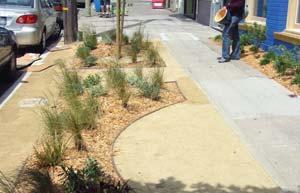
13 6.0 GUIDE: STREETSCAPE ELEMENTS Chapter 6 describes guidelines for streetscape elements typically found in sidewalks or curb extensions, including: street trees and plantings, stormwater control measures, street and pedestrian lighting, paving, site furnishings, utilities, and driveways. 6.1 Urban forest The urban forest consists of street trees, understory plantings (ground landscaping), and above-ground plantings (planter boxes or hanging planters). Urban forest elements should be appropriate to soil and microclimate zones. Drought-tolerant and climate-adapted species should be used. Native plantings should be used when it is possible to maintain healthy plantings. Street trees should be the primary organizing element of the streetscape; restrictions and conflicts with other elements should be minimized to ensure consistent plantings. Tree basins should be optimized to ensure tree health and minimize root interference with sidewalks. Tree furnishings such as grates, guards or railings may be used for a design treatment; however, they may be difficult to maintain or inhibit tree health. Understory plantings should be used in furnishings zones on most street types, with sufficient area for healthy plantings. They may have a formal or more naturalistic treatment, depending on the context. Sidewalk landscaping may be present and still allow access to parked cars and utilities if designed properly. Above-ground landscaping is appropriate in limited circumstances such as in special design areas, or where in-ground landscaping is not possible due to utilities or other constraints. 6.2 Stormwater control measures Stormwater control measures are on-street stormwater facilities that capture stormwater before it enters the City s combined or separate stormwater systems. This treatment can result in fewer combined sewer overflows into the bay or ocean. Stormwater control measures can be designed to infiltrate, retain, detain, convey, and treat stormwater. Infiltration may not be possible in all locations. For more technical details, refer to the San Francisco Stormwater Design Guidelines. Stormwater management tools include permeable paving, bioretention facilities, swales, channels and runnels, infiltration trenches, infiltration boardwalks, vegetated gutters, and vegetated buffer strips. All of these features may be designed to be integral, aesthetic parts of the streetscape in addition to their stormwater management role. 6.3 Lighting Street lighting is a key organizing element that defines the daytime and nighttime environment and enhances personal safety and security. Street lights should light the entire right-of-way; specific pedestrian-oriented lighting is appropriate in downtown, civic, and commercial areas with high numbers of pedestrians. Lighting should be spaced to optimize light distribution and not interfere with other streetscape elements, particularly street trees. Street lights should use energy efficient technologies, and minimize light loss to the night sky. Lighting guidelines should be further developed through a street lighting master plan. 6.4 Paving Paving materials in the pedestrian realm can be either standard concrete or non-standard materials, such as brick, stone, or unit pavers. Paving should be functional stable, firm, slip-resistant, and relatively easy to maintain. It may also provide a unique design treatment, particularly on special streets or in areas of the street environment meant for pausing rather than walking through. Special paving may be considered at transit stops, crosswalks, pedestrian refuges, shared public ways, local lanes of boulevards, transit malls, pedestrian-only streets, flexibly used parking lanes, curb extensions, or in the furnishings zone of the sidewalk. 6.5 Site furnshings Site furnishings consist of all streetscape amenities in the sidewalk, including: benches and seating, bicycle racks, bollards, flowerstands, kiosks, newsracks, parking meters, public art, sidewalk restrooms, traffic and parking signs, trash receptacles, and signage and gateways. Generally, site furnishings should be located in the furnishings zone. Site furnishings should be considered design elements, and use consistent, aesthetic design along a particular street or corridor. They should meet basic clearances and requirements for accessibility, maintenance, and safety. 6.6 Utilities and driveways Utilities and driveways are functional elements that provide necessary access and facilities. Utilities may be poles, overhead wires, surface-mounted boxes, underground vaults, mains and laterals. They are a necessary and ubiquitous element of streetscape environments; however, they often conflict with other streetscape elements, and vice versa. Utilities should be efficiently located to minimize impacts on other existing or potential streetscape elements, maintain basic access and maintenance requirements, and be consolidated into shared vaults, boxes, or trenches wherever possible. Likewise, driveways should be minimized and located to avoid impacts to existing or potential streetscape elements. 7.0 IMPLEMENTATION Chapter 7 describes implementation measures necessary to carry out the vision of the Better Streets Plan, including funding, maintenance, and enforcement strategies. The Controller s Office report: Better Streets Plan: Recommendations for Improved Streetscape Project Planning, Design, Review and Approval contains additional implementation recommentations. EXECUTIVE SUMMARY B E T T E R S T R E E T S P L A N v


14


15 CHAPTER 1.0 INTRODUCTION 1.1 Background 1.2 Plan Development 1.3 Moving Forward INTRODUCTION The Better Streets Plan provides a blueprint for the future of San Francisco s pedestrian environment. It describes a vision, creates design guidelines, and identifies next steps for the City to take to create a truly great pedestrian realm.


16 What is a Better Street? A Better Street is designed and built to strike a balance between all users regardless of physical abilities or mode of travel. A Better Street attends to the needs of people first, considering pedestrians, bicyclists, transit, street trees, stormwater management, utilities, and livability as well as vehicular circulation and parking.

17 Background 1.1 BETTER STREETS PLAN PURPOSE Streets make up fully 25% of San Francisco s land area, more area even than is found in the city s parks. The City s streets are one of its most memorable features; the city s famous hilly terrain is made all the more scenic by the steady march of streets over its rolling topography to the water s edge. However, the scenic vistas visible from and along so many of the city s streets have made it too easy to ignore the untapped potential of the streets themselves San Francisco s streets are vastly underutilized resources. San Francisco is renowned for its quality of life, commitment to social equity and growing concern for environmental sustainability. The City s Charter declares that transit, bicycle, and pedestrian use of street space take precedence over private vehicle use. The City strives to provide services, infrastructure, and lifestyle opportunities for people from all walks and stages of life: families with children, young professionals, senior citizens, and everyone inbetween. These goals seek to maintain and enhance San Francisco s role as one of the premier world cities. As San Francisco continues to mature and evolve it faces many challenges in supporting this vision of itself as a world-class city. Families with children are leaving the city more quickly than they are arriving. Pedestrian injuries and fatalities continue to occur on busy streets. Many neighborhoods lack open space for recreational activities or places for neighbors to gather. The quality of streets and public spaces is slowly deteriorating amid structural budget deficits. The need to address concerns about air and CHAPTER 1.0 Noe Street B E T T E R S T R E E T S P L A N 3


18 CHAPTER 1: INTRODUCTION CHAPTER 1.0 water quality and global climate change grows increasingly urgent each passing day. Well-designed streets that serve a multitude of uses can help to address these concerns. Each year, the City spends millions of dollars maintaining and improving city streets, yet too often the streets serve only a single purpose the movement of automobiles. With improved planning and coordination, San Francisco could use this money to transform its streets to meet the City s many objectives for streets, including enhancement of all types of travel, improved ecological performance, encouragement of physical activity for public health, and restoring the streets rightful role as the heart of the city s public life. The Better Streets Plan provides a blueprint for achieving this multi-use vision of streets streets that continue to function as corridors of movement while at the same time reach their potential for enhanced community life, recreational opportunities, and ecological benefits. As San Francisco continues to grow, the Better Streets Plan will help to ensure that it can fulfill its vision of a world-class city one that is renowned not just for the views from its streets, but for the quality of the streets themselves and the vibrant public life that they foster. PLAN BENEFITS The Better Streets Plan describes a set of guidelines for the pedestrian realm. As street improvements are built over time using the Better Streets Plan, the City will realize a number of essential benefits from improved street design. These benefits include: Help retain families in San Francisco: Streets that are safe from fast-moving traffic, are clean and wellmaintained, and have spaces for neighbors to gather or children to play will help to retain families in San Francisco, much as affordable housing or good public schools will do the same. Support Muni and a transit-first city: Every transit trip begins and ends with a walking trip. Well designed streets that are safe and convenient for pedestrians and connect to important transit lines will encourage greater use of the transit system. Help promote public safety: Active streets that provide eyes on the street will enhance peoples sense of safety and security from crime and violence. Help improve public health: Walkable, livable streets encourage physical activity and social cohesion, leading to a decrease in obesity, chronic diseases, and social isolation. Benefits of the Better Streets Plan Help retain families in San Francisco Support Muni and a transit-first city Help promote public safety Help improve public health Help to minimize impact on global climate change and local air pollution Help to minimize sewer/stormwater overflows into the Bay Decrease the likelihood of pedestrian injuries and fatalities Increase accessibility for all street users Support the City s local shopping districts and small businesses Support neighborliness, civic interaction, and identity Enhance the everyday quality of life for San Francisco s residents What is the pedestrian environment? The term pedestrian environment refers to the areas of the street where people walk, shop, sit, play, or interact outside of moving vehicles. Generally speaking, this refers to the sidewalk areas between the property line and the curb, and the crossing areas at intersections. However, the pedestrian environment can also include portions of the street normally associated with vehicular traffic such as during street fairs or farmer s markets, or the entire street on small streets such as alleys or pedestrian pathways. The pedestrian environment 4 B E T T E R S T R E E T S P L A N


19 1.1 BACKGROUND Recent San Francisco projects such as Octavia Boulevard (top) and Mint Plaza (bottom) show how streets can be transformed into active and green public spaces Help to minimize impact on global climate change and local air pollution: Streets that are designed to promote walking, cycling, and transit use over private automobile use will help to minimize San Francisco s contribution to global climate change and reduce local air pollution. Help to minimize sewer/stormwater overflows into the Bay: Streets can be designed to detain a certain percentage of water during big storms, to reduce overflows of the City s combined stormwater and sewer infrastructure into the bay and minimize local flooding problems. Decrease the likelihood of pedestrian injuries and fatalities: Streets that are designed with the safety of pedestrians in mind will decrease the likelihood of pedestrian/auto collisions and the number of pedestrian injuries and fatalities that occur each year. Increase accessibility for all street users: Streets that have a clear, accessible path of travel and are free from barriers and obstructions will result in increased usability for all users, including people with disabilities, seniors, children, parents with strollers, and everyone else. Support the City s local shopping districts and small businesses: A street system that encourages people to walk to neighborhood commercial districts rather than drive to regional shopping centers for their daily needs helps to support the small commercial areas and small businesses that make up an important part of San Francisco s character and economy. Provide open space in areas that are lacking: There is increasing pressure on the City s existing open spaces, and a need for open space in new neighborhoods. The city s street system can complement and link to the larger open space network, bringing more open space to underserved neighborhoods. Support neighborliness, civic interaction, and identity: Cities depend on peaceful interactions of colleagues, neighbors, and strangers who share a collective identity and pride as the residents of a place. Well-designed streets that include places to sit, stop, gather, and play create the spaces for this interaction to take place. Enhance the everyday quality of life for San Francisco s residents: Above all, a well-designed street system will enhance the City s livability for San Francisco s residents, workers, and visitors, by providing pleasant places to stroll or sit, opportunities for neighborly interaction, freedom from excessive noise and pollution, and a green, attractive cityscape. For the Better Streets Plan to help achieve these benefits, the City must reform many of its current standards, guidelines, and practices relating to street design, construction and maintenance. These practices, standards and guidelines found in the City s codes, plans, and departmental orders are strong determinants of the resulting street environment that we see and use everyday. Many of these codes are old or out of date, and often conflict with one another. Many were adopted during times when thinking about streets, technologies, and ecological best practices was different than it is today, and often reflect a single-use vision for streets that does not account for the multitude of uses that streets can serve. The Better Streets Plan seeks to balance and reconcile these codes while considering all potential street uses; the legislation accompanying the Better Streets Plan adoption updated many of these codes. Additionally, there must be an on-going commitment from the City to ensure that future changes to the public rightof-way are consistent with the Better Streets Plan. This document provides a guide for City agencies, community members, and private developers and anyone else making changes to the pedestrian realm. This guide must be complemented with an on-going commitment from the City s elected officials and department heads to funding, staffing, building, and maintaining Better Streets improvements. CHAPTER 1.0 B E T T E R S T R E E T S P L A N 5


![5 ] Pedestrian-oriented](/docs-images/84/91147228/images/20-6.jpg "lighting [ 6.")
![3 ] Minimize site](/docs-images/84/91147228/images/20-7.jpg "cluttering [ 6.")
![5 ] Reclaim excess](/docs-images/84/91147228/images/20-8.jpg "street space for public")


![5 ] Merchant](/docs-images/84/91147228/images/20-11.jpg "participation [ 6.")
![5 ] Visible crossings [](/docs-images/84/91147228/images/20-12.jpg "5.1 ] Slower turning")


![[ 5.8 ] Temporary or](/docs-images/84/91147228/images/20-15.jpg "permanent street")

![5.1 ] Generous,](/docs-images/84/91147228/images/20-17.jpg "unobstructed sidewalks")
![[ 4.2 ] Curb ramps for](/docs-images/84/91147228/images/20-18.jpg "all users [ 5.")
![1 ] Accessible](/docs-images/84/91147228/images/20-19.jpg "pedestrian signals [ 5.")
![1 ] CREATIVE USE OF](/docs-images/84/91147228/images/20-21.jpg "PARKING LANE ECOLOGY")


20 PLAN HIGHLIGHTS DISTINCTIVE, UNIFIED OVERALL DESIGN SPACE FOR PUBLIC LIFE PEDESTRIAN SAFETY PEDESTRIAN PRIORITY UNIVERSAL DESIGN CHAPTER 1.0 Integrated site furnishings [ Section 6.5 ] Pedestrian-oriented lighting [ 6.3 ] Minimize site cluttering [ 6.5 ] Reclaim excess street space for public use [ 5.8 ] Safe public seating for neighborhood gathering [ 6.5 ] Merchant participation [ 6.5 ] Visible crossings [ 5.1 ] Slower turning speed [ 5.2 ] Shorter crossing distances [ 5.3 ] Shared public ways [ 5.8 ] Temporary or permanent street closures [ 5.8 ] Raised crossings [ 5.1 ] Generous, unobstructed sidewalks [ 4.2 ] Curb ramps for all users [ 5.1 ] Accessible pedestrian signals [ 5.1 ] CREATIVE USE OF PARKING LANE ECOLOGY EXTENSIVE GREENING INTEGRATING PEDS AND TRANSIT RECLAIMING EXCESS STREET SPACE Flexible use for cafe seating [ 5.6 ] Permanent mini-plazas [ 5.3 ] Landscaping in the parking lane [ 6.1 ] Stormwater management [ 6.2 ] Permeable materials [ 6.2 ] Streets as habitats [ 6.1 ] Healthy urban forest [ 6.1 ] Expanded sidewalk plantings [ 6.1 ] Utility consolidation [ 6.6 ] Transit rider amenities [ 5.5 ] Bus bulbouts and boarding islands [ 5.5 ] Safe, convenient routes to transit [ 5.5 ] Street parks and new plazas [ 5.8 ] Traffic circles [ 5.7 ] Landscaped medians [ 5.4 ] 6 B E T T E R S T R E E T S P L A N

21 1.1 BACKGROUND Street Delivery in San Francisco Streets in San Francisco are regulated and managed by a variety of agencies, reflecting specific areas of expertise. Although this is sometimes necessary to provide specific technical know-how, there is no one body coordinating streetscape design projects. As a result, individual decisions about street design, use, prioritization, and management do not add up to streets that reflect the City s goals for the character of our streets. The Better Streets Plan posits a new manner of designing and building streets in San Francisco. Streets should be designed with greater agency coordination, and individual decisions should add up to an integrated whole that prioritizes the needs of people. Each design or management decision should bring the City closer to the collective vision for streets. As a follow-up action to the Better Streets Plan, the Controller s Office has analyzed the City s street design process and made recommendations for its improvement. See the Controller s Office report: Better Streets Plan: Recommendations for Improved Streetscape Planning, Design, Review, and Approval, available at PROCESS Business as usual Independent agencies with competing goals Lack of overall framework for street improvements Lack of coordination for street programming and funding Ad hoc coordination on street design and use Planning for individual elements Competing visions for streets/lack of overall vision for streets City priorities not clearly defined Better Streets Plan Coordinated agencies working toward citywide goals Integrated framework for street improvements Coordinated programming and funding for street improvements Centralized coordination on street design and use Planning for streets as a whole Unified vision for streets Citywide priorities clearly defined CHAPTER 1.0 Uncoordinated use of City resources Efficient use of City resources More numerous and more complete street projects RESULT Cluttering streetscape elements Streets with lack of unifying aesthetic Streets that do not serve well as public spaces Multi-purpose projects with greater competitiveness for funding Unified street design Lack of greenery Fewer cluttering streetscape elements Lack of ecological functioning Streets with a healthy public realm Increased greenery and ecological functioning Enhanced safety and accessibility Jurisdiction over streets is divided among numerous agencies, including those shown here, and others as well B E T T E R S T R E E T S P L A N 7


22 This photo-simulation illustrates how the Better Streets Plan guidelines could be applied to a typical mixed-use San Francisco street to improve the pedestrian environment Photosimulations are for visualization purposes only, and are not intended to show specific details and dimensions


23 This photo-simulation illustrates how the Better Streets Plan guidelines could be applied to improve the pedestrian environment on a typical residential San Francisco street


24 The Better Streets Plan is a partnership among City departments and agencies, with the goal of coordinating and streamlining the City s street design processes and resulting in a more gracious pedestrian realm.
, which requires the City to consider the multiple objectives for streets in all decisions about the public right-of-way.")
25 Plan Development 1.2 HISTORY OF THE PLAN In February 2006, the Board of Supervisors passed the Better Streets Policy (Administrative Code Section 98.1 shown in Attachment A), which requires the City to consider the multiple objectives for streets in all decisions about the public right-of-way. Responding to this policy, City departments joined together to work on the Better Streets Plan, to provide a single comprehensive, consistent set of guidance for the design of the pedestrian realm. Work on the Better Streets Plan began in Fall 2006, with a public kick-off in April The Better Streets Plan Draft for Public Review was published in June 2008, Plan Revisions in October 2009, and the Final Draft in July The Better Streets Plan and accompanying amendments to the City s General Plan and Municipal Codes were adopted by the Board of Supervisors on December 7, The Better Streets Plan is a unique collaboration among all of the agencies involved in the funding, design, and management of streets citywide, including the Planning Department, San Francisco Municipal Transportation Agency (SFMTA), San Francisco Public Utilities Commission (SFPUC), Department of Public Works (DPW), Department of Public Health (DPH), Mayor s Office on Disability (MOD), Mayor s Office on City Greening, and the San Francisco County Transportation Authority (SFCTA). Staff from each of these agencies (the Better Streets team ) met bi-weekly to develop the plan, and gave frequent updates to Department leadership. The Better Streets team convened a wider Technical Advisory Committee (TAC) of over 50 staff from 15 City departments who work in design and management of the public right-of-way. The Better Streets Plan TAC met multiple times over the course of the project to comment on the technical feasibility of plan proposals. Additionally, the Better Streets team convened a 15 member Community Advisory Committee, which met monthly over a two-year period to provide input into plan as it was developed. Finally, the Better Streets Team held a significant public outreach program, summarized in the following section. CHAPTER 1.0 B E T T E R S T R E E T S P L A N 11


26 CHAPTER 1: INTRODUCTION CHAPTER 1.0 SUMMARY OF PUBLIC OUTREACH In order to create the Better Streets Plan, the Better Streets Team conducted significant community involvement efforts to present plan concepts and gather public input. Over five rounds of community involvement, the Better Streets Team held over 100 community meetings, and received over 1,000 responses to two Better Streets Plan surveys. Mayor Gavin Newsom kicked off the community involvement for the Better Streets Plan in April 2007, at a project kick-off meeting at City Hall attended by over 200 members of the public. Following the kick-off meeting, in April through June 2007, City agencies held four public workshops around the city, seven focus groups, and over 25 neighborhood meetings with community groups by request. The second round of outreach took place from July through September 2007, and consisted of over 40 events, including focus groups, stakeholder interviews with a variety of advocacy and community organizations, neighborhood meetings with community groups, street-side tabling events, and a youth walking tour. In June 2008, Mayor Gavin Newsom formally released the Draft Better Streets Plan for Public Review at a public event in Mint Plaza. Following the plan release event, the Better Streets Team held a third round of outreach to gather feedback on the Draft Plan, consisting of several community meetings and a walking tour. The fourth round of outreach, held in October 2009 to coincide with the release of the Plan Revisions, consisted of public informational hearings to the City s Boards and Commissions, and public discussions hosted by local organizations. The fifth and final round of outreach involved public hearings to adopt the Plan and associated legislative amendments. A full list of community meetings is included in Appendix D. Through the public outreach, participants could give their input in multiple ways, including facilitated small group exercises, comment boards, questions and answer sessions, surveys, comment sheets, and informal discussion and correspondence. Respondents to the first Better Streets Plan survey rated the five most important street improvements as: street trees; greenery (landscaping other than trees); sidewalk maintenance; clear sidewalks (free from obstructions); and slower traffic. Round 1 Survey Responses: Average Score for Street Improvements (Scale of 1 to 7, 7 being most important) Trees 5.6 Greenery 5.4 Sidewalk Maintenance 5.3 Blocked Sidewalks 5.3 Slower Traffic 5.3 Pedestrian Lighting 5.1 Places to Sit 5.0 Crosswalk Conditions 5.0 Sidewalk Materials 4.8 Countdown Signals 4.8 Wider Sidewalks 4.6 Narrow Street Crossings 4.1 Curb Ramps 4.0 A broader summary of community input is included in Appendix D. Better Streets Plan kick-off event at City Hall (left) and street-side tabling event (right) 12 B E T T E R S T R E E T S P L A N
 Community Involvement Milestones to Date 5")


27 1.2 PLAN DEVELOPMENT The Better Streets Team held over 100 public meetings and events across the city. Each red dot marks the location of a Better Streets public outreach event (some locations held multiple events) Community Involvement Milestones to Date 5 rounds of community involvement Over 100 community meetings Over 500 attendees Over 1,000 responses to two Better Streets Plan surveys CHAPTER 1.0 Participants at the Better Streets Plan youth walking tour ADA Transition Plan Outreach In coordination with the Better Streets Plan, the CIty conducted public outreach to provide input to the City s ADA Transition Plans for Curb Ramps and Sidewalks, which describe the City s priorities for installing accessible curb-ramps and barrier-free sidewalks. Five meetings were hosted by community organizations and directed at seniors and people with mobility, visual, or cognitive impairments. Participants were asked their priorities for installing these features. The priority improvements identified by participants included: install new curb ramps instead of fixing existing (unless unsafe); focus on high-need areas throughout the city instead of moving district-by-district; fix sidewalks broken by tree roots; provide accessible wayfinding signage; remove obstructions such as low branches, parked cars, tables, merchant signs and displays, and bikes and skateboards; For more information on the ADA Transition Plans for Curb Ramps and Sidewalks, see: B E T T E R S T R E E T S P L A N 13


28


29 Moving Forward 1.3 FUTURE ACTIONS The Better Streets Plan provides a comprehensive vision and guidelines for the design of the City s pedestrian realm. However, it is not enough for the City to simply adopt the Better Streets Plan. The City must also follow through to consistently use the Better Streets Plan and build projects that adhere to the Plan s vision. To achieve this, the City should take a number of additional steps. Some of these steps are already funded and on-going; others have not yet begun and lack adequate funding. Improve the City s street design process The Better Streets Plan process has illustrated how City agencies can work together in the design of streets. However, it has also highlighted the challenges of doing so on an on-going basis. The Better Streets Team is working with the Controller s Office to study the City s existing street design and maintenance process and make recommendations for its improvement. See the Controller s Office report, available at Develop a Better Streets Plan user guide and interactive website The City should create a user-friendly guide and website to easily communicate the relevant guidelines, permits and resources in one place to anyone proposing to make changes to the public right-of-way. The Better Streets Plan is a living document and will be amended over time to reflect new thinking. The user guide and website would be updated accordingly, such that there is a single, comprehensive location for information about making street changes. CHAPTER 1.0 Moving Forward: Summary Improve the City s street design process Develop Better Streets Plan user guide and website Develop implementation and funding framework Develop additional technical plans (street and pedestrian lighting, street furnishings, roadway design manual) B E T T E R S T R E E T S P L A N 15
s a n f r a n c i s c o
 s a n f r a n c i s c o BETTER STREETS PLAN Policies and Guidelines for the Pedestrian Realm F I N A L D R A F T R E L E A S E P A C K E T J U L Y 2 0 1 0 i n s i d e : L E T T E R F R O M M A Y O R G
Proposed. City of Grand Junction Complete Streets Policy. Exhibit 10
 Proposed City of Grand Junction Complete Streets Policy Exhibit 10 1 City of Grand Junction Complete Streets Policy Vision: The Complete Streets Vision is to develop a safe, efficient, and reliable travel
Vision. cultural identity, income group, neighborhood identity, or mobility level. Rendering by Robin Chiang
 Vision Rendering by Robin Chiang The will result in a street system designed to promote human needs for the use and enjoyment of these public spaces by all. It will prioritize the needs of walking, bicycling,
Ocean Park Boulevard Green Street Project Alternatives & Trade Offs
 Planning Commission March 4, 2009 Ocean Park Boulevard Green Street Project Alternatives & Trade Offs Purpose of Tonight s Meeting Review concept plans and options Provide input on alternatives and trade-offs
3.0 GOALS & POLICIES: THE PATH TO BETTER STREETS
 CHAPTER CHAPTER 3.0 GOALS & POLICIES 3.1 Vision 3.2 Preface to Goals and Policies 3.3 Ten Elements of Better Streets GOALS & POLICIES: THE PATH TO BETTER STREETS San Francisco s streets should be designed
Bicycle and Pedestrian Advisory Committee (BPAC) November 21, 2013
 November 21, 2013") Bicycle and Pedestrian Advisory Committee (BPAC) November 21, 2013 OVERALL LAND USE CONCEPT Overall Broadway Valdez District: 95.5 acres (35.1 acres right-of ways + 60.4 acres developable land) Plan Subareas:
Bicycle and Pedestrian Advisory Committee (BPAC) November 21, 2013 OVERALL LAND USE CONCEPT Overall Broadway Valdez District: 95.5 acres (35.1 acres right-of ways + 60.4 acres developable land) Plan Subareas:
PEDESTRIAN ACTION PLAN
 ATTACHMENT 2 CITY OF SANTA MONICA PEDESTRIAN ACTION PLAN CITY OF SANTA MONICA PEDESTRIAN ACTION PLAN This page intentionally left blank EXECUTIVE SUMMARY CHAPTER 1 EXECUTIVE SUMMARY Setting the Stage
CONNECTIVITY PLAN. Adopted December 5, 2017 City of Virginia Beach
 CONNECTIVITY PLAN Adopted December 5, 2017 City of Virginia Beach CONTENTS 1.0 Background & Purpose... 2 2.0 Existing Inventory & Analysis... 3 ViBe District Existing Walking Conditions... 4 3.0 ViBe District
A CHANGING CITY. of Edmonton, it is essential that it reflects the long-term vision of the City.
 A CHANGING CITY By the year 2040, Edmonton will be home to more than 1 million people. To accommodate growth and support a healthy and compact city, we need a new approach to development/redevelopment
Ann Arbor Downtown Street Plan
 1 Ann Arbor Downtown Street Plan Public Workshop #1 We know that. 2 Public right-of-way (streets, sidewalks, and alleys) make up 30% of the total District area of downtown. Streets need to provide mobility
Living Streets Policy
 Living Streets Policy Introduction Living streets balance the needs of motorists, bicyclists, pedestrians and transit riders in ways that promote safety and convenience, enhance community identity, create
CHAPTER 7.0 IMPLEMENTATION
 CHAPTER 7.0 IMPLEMENTATION Achieving the vision of the Better Streets Plan will rely on the ability to effectively fund, build and maintain improvements, and to sustain improvements over time. CHAPTER
Complete Streets. Designing Streets for Everyone. Sarnia
 Complete Streets Designing Streets for Everyone Sarnia Complete Streets ~ Sarnia ~ 2018 Introduction Our City is made up of a network of streets that we use to go for a walk, cycle to work, drive to the
Ocean Park Boulevard Streetscape Improvement Project Alternatives & Trade Offs
 City Council Study Session January 27, 2009 Ocean Park Boulevard Streetscape Improvement Project Alternatives & Trade Offs Scope of Work Purpose of Tonight s Meeting Review work to date and direct staff
Bicycle Master Plan Goals, Strategies, and Policies
 Bicycle Master Plan Goals, Strategies, and Policies Mobilizing 5 This chapter outlines the overarching goals, action statements, and action items Long Beach will take in order to achieve its vision of
Corpus Christi Metropolitan Transportation Plan Fiscal Year Introduction:
 Introduction: The Safe, Accountable, Flexible, Efficient Transportation Equity Act: A Legacy for Users (SAFETEA-LU) has continued the efforts started through the Intermodal Surface Transportation Efficiency
Environment and Public Works Committee Presentation
 Mixed Use Centers Complete Streets Guidelines Project Environment and Public Works Committee Presentation December 10, 2008 Project Objectives: Conduct an inter-departmental and agency process to study
Tonight is for you. Learn everything you can. Share all your ideas.
 Strathcona Neighbourhood Renewal Draft Concept Design Tonight is for you. Learn everything you can. Share all your ideas. What is Neighbourhood Renewal? Creating a design with you for your neighbourhood.
EXECUTIVE SUMMARY. Vision
 Vision Walking and bicycling in Salt Lake City will be safe, convenient, comfortable, and viable transportation options that connect people to places, foster recreational and economic development opportunities,
REGIONAL BICYCLE AND PEDESTRIAN DESIGN GUIDELINES
 REGIONAL BICYCLE AND PEDESTRIAN DESIGN GUIDELINES November 16, 2011 Deb Humphreys North Central Texas Council of Governments Bicycle and Pedestrian Advisory Committee Snapshot of the Guide 1. Introduction
Make Lincoln Highway an economically vibrant corridor that is safe, efficient, and beautiful for local residents and visitors.
 Lincoln Highway Streetscape Plan Stakeholder Workshop #2 Handout Contents Introduction and Project Vision Planning Principles Specific Recommendations including a Proposed Typical Roadway Section Renderings
RESOLUTION NO ?? A RESOLUTION OF THE CITY OF NEPTUNE BEACH ADOPTING A COMPLETE STREETS POLICY
 RESOLUTION NO. 2018-?? A RESOLUTION OF THE CITY OF NEPTUNE BEACH ADOPTING A COMPLETE STREETS POLICY WHEREAS, safe, convenient, and accessible transportation for all users is a priority of the City of Neptune
PRINCE GEORGE S PLAZA METRO AREA PEDESTRIAN PLAN
 PRINCE GEORGE S PLAZA METRO AREA PEDESTRIAN PLAN May 28, 2008 Agenda Welcome and introductions Project overview and issue identification Planning context and strengths Design challenges and initial recommendations
Perryville TOD and Greenway Plan
 Perryville TOD and Greenway Plan Greenway Glossary Pathway: A bicycle and pedestrian path separated from motorized vehicular traffic by an open space, barrier or curb. Multi-use paths may be within the
Executive Summary Route 30 Corridor Master Plan
 Route Corridor Master Plan Project Overview The Route Corridor Master Plan is a coordinated multimodal transportation and land use plan for the entire stretch of Route through East Whiteland Township,
Broad Street Bicycle Boulevard Design Guidelines
 Broad Street Bicycle Boulevard Design Guidelines Building from the strategies introduced in the 2013 Bicycle Transportation Plan and community input received thus far, City Transportation Staff have identified
FOLSOM-HOWARD STREETSCAPE OVERVIEW
 FOLSOM-HOWARD STREETSCAPE OVERVIEW SoMa residents should have the same kinds of amenities that other neighborhoods have. The Folsom- Howard Streetscape Project will make SoMa more livable by making it
Agenda. Overview PRINCE GEORGE S PLAZA METRO AREA PEDESTRIAN PLAN
 PRINCE GEORGE S PLAZA METRO AREA PEDESTRIAN PLAN May 28, 2008 Agenda Welcome and introductions Project overview and issue identification Planning context and strengths Design challenges and initial recommendations
Chapter VISION, MISSION, AND GOALS AND OBJECTIVES. Vision. Mission. Goals and Objectives CONNECTING COMMUNITIES ACROSS THE ST.
 VISION, MISSION, AND GOALS AND OBJECTIVES Chapter 3 The Plan s vision, mission, and goals and objectives were developed through a series of interactive exercises with the Citizens Advisory Committee (CAC)
7 Complete Streets & Roadway Aesthetics
 7 Complete Streets & Roadway Aesthetics 7.1 OVERVIEW Our streets lay the foundation for how we interface with travel needs, physical exercise, social exchanges and access to goods and services. They are
Omaha s Complete Streets Policy
 Omaha s Complete Streets Policy (Adopted August 2015) VISION To create great places and enhance our quality of life, the City of Omaha will provide safe, accessible streets for all users. Complete Streets
Caltrans Sloat Boulevard Pedestrian Safety Project Response to Community Questions, Comments & Concerns
 Caltrans Sloat Boulevard Pedestrian Safety Project Response to Community Questions, Comments & Concerns Revised: May 10, 2016 The California Department of Transportation (Caltrans) is planning various
TRAVEL PLAN: CENTRAL EUROPEAN UNIVERSITY CAMPUS REDEVELOPMENT PROJECT TRAVEL PLAN. Central European University Campus Redevelopment Project.
 TRAVEL PLAN Central European University Campus Redevelopment Project Page 1 Table of Contents Introduction... 3 Background... 7 Building Users... 7 Transportation in Community Consultation... 7 Summary
Chapter 3: Multi-Modal Circulation and Streetscapes
 CHAPTER 3: MULTI-MODAL CIRCULATION AND STREETSCAPES Chapter 3: Multi-Modal Circulation and Streetscapes Overview Streetscape improvements have already been completed for Depot Street between Main Avenue
CITY OF COCOA BEACH 2025 COMPREHENSIVE PLAN. Section VIII Mobility Element Goals, Objectives, and Policies
 CITY OF COCOA BEACH 2025 COMPREHENSIVE PLAN Section VIII Mobility Element Goals, Objectives, and Policies Adopted August 6, 2015 by Ordinance No. 1591 VIII MOBILITY ELEMENT Table of Contents Page Number
INDOT Complete Streets Guideline & Policy
 INDOT Complete Streets Guideline & Policy INTRODUCTION The Complete Streets guidelines build upon multiple efforts and promote a multimodal transportation system that is integrated and sustains land use
City of Novi Non-Motorized Master Plan 2011 Executive Summary
 City of Novi Non-Motorized Master Plan 2011 Executive Summary Prepared by: February 28, 2011 Why Plan? Encouraging healthy, active lifestyles through pathway and sidewalk connectivity has been a focus
STONY PLAIN ROAD STREETSCAPE
 Jasper Place Revitalization Strategy: Vision The people involved in the Jasper Place Revitalization Strategy envision: Goal 1: Feeling safe in our community Create a community where feeling safe is common--where
Off-road Trails. Guidance
 Off-road Trails Off-road trails are shared use paths located on an independent alignment that provide two-way travel for people walking, bicycling, and other non-motorized users. Trails specifically along
Vision: Traditional hamlet with an attractive business/pedestrian friendly main street connected to adjacent walkable neighborhoods
 N D. Focus Area II Vision: Traditional hamlet with an attractive business/pedestrian friendly main street connected to adjacent walkable neighborhoods Transit Road Focus Area II is located in the Hamlet
Report. Typical Sections. City of Middleton, WI
 Report Typical Sections City of Middleton, WI December 2006 Report for City of Middleton, Wisconsin Typical Sections repared by: Traffic Associates LLC and STRAND ASSOCIATES, INC. 910 West Wingra Drive
Aurora Urban Street Standards For Transit Oriented Developments and Urban Centers
 Aurora Urban Street Standards For Transit Oriented Developments and Urban Centers I. Purpose These standards will be applied to create a safe, comfortable, pleasant and pedestrian-friendly multi-modal
Ocean Park Boulevard Green Street Project Community Workshop
 Ocean Park Boulevard Green Street Project Community Workshop 2.2.10 Project Objectives Community Priority: reclaim OPB for public open space. Build upon LUCE principles; neighborhood enhancement, connectivity,
COUNCIL POLICY NAME: COUNCIL REFERENCE: 06/119 06/377 09/1C 10llC 12/1C INDEX REFERENCE: POLICY BACKGROUND
 COUNCIL POLICY NAME: COUNCIL ADVISORY COMMITTEES - TERMS OF REFERENCE ISSUED: APRIL 3, 2006 AMENDED: NOVEMBER 27, 2006 NOVEMBER 23, 2009 JANUARY 11, 2010 DECEMBER 17, 2012 POLICY COUNCIL REFERENCE: 06/119
7/23/2017 VIA . Michael Hanebutt City of Sacramento Community Development Department 300 Richards Boulevard, 3 rd Floor Sacramento, CA 95811
 7/23/2017 VIA EMAIL Michael Hanebutt City of Sacramento Community Development Department 300 Richards Boulevard, 3 rd Floor Sacramento, CA 95811 RE: 65 th Street Apartments (DR17-220) Dear Mr. Hanebutt:
BROOKLAND Multi-Modal Transportation & Streetscape Study* NE Washington, DC
 BROOKLAND Multi-Modal Transportation & Streetscape Study* NE Washington, DC The study s goal is to create a multi-modal transportation and streetscape design plan to increase transportation efficiency,
AMATS Complete Streets Policy
 AMATS Complete Streets Policy Table of Contents: Section 1. Definition of Complete Streets Section 2. Principles of Complete Streets Section 3. Complete Streets Policy Section 4. Consistency Section 5.
Exhibit 1 PLANNING COMMISSION AGENDA ITEM
 Exhibit 1 PLANNING COMMISSION AGENDA ITEM Project Name: Grand Junction Circulation Plan Grand Junction Complete Streets Policy Applicant: City of Grand Junction Representative: David Thornton Address:
TOWN OF PORTLAND, CONNECTICUT COMPLETE STREETS POLICY
 TOWN OF PORTLAND, CONNECTICUT COMPLETE STREETS POLICY I. VISION, GOALS & PRINCIPLES VISION To improve the streets of Portland making them safer and more accessible for all users including pedestrians,
UPTOWN REGIONAL BIKE CORRIDORS PROJECT SAN DIEGO ASSOCIATION OF GOVERNMENTS
 UPTOWN REGIONAL BIKE CORRIDORS PROJECT SAN DIEGO ASSOCIATION OF GOVERNMENTS SUMMARY REPORT: COMMUNITY UPDATE MEETING February 6, 2014 6 8:30 p.m. Roosevelt Middle School Library 3366 Park Blvd, San Diego
May 12, 2016 Metro Potential Ballot Measure Issue Brief: Local Return
 Summary: Local return is an important revenue source for cities to maintain their local transportation infrastructure. Most cities use their local return to operate small bus systems and repave streets,
12/4/2016 VIA . RE: Grocery Outlet Del Paso (DR16-328)
") 12/4/2016 VIA EMAIL Ethan Meltzer, Assistant Planner City of Sacramento Community Development Department 300 Richards Blvd, 3 rd Floor Sacramento, CA 95811 RE: Grocery Outlet Del Paso (DR16-328) Dear Mr.
12/4/2016 VIA EMAIL Ethan Meltzer, Assistant Planner City of Sacramento Community Development Department 300 Richards Blvd, 3 rd Floor Sacramento, CA 95811 RE: Grocery Outlet Del Paso (DR16-328) Dear Mr.
MAG Town of Cave Creek Bike Study Task 6 Executive Summary and Regional Significance Report
 Page 1 MAG Town of Cave Creek Bike Study Task 6 Executive Summary and Regional Significance Report August 1, 2012 MAG Project #481 Page 2 Task 6 Executive Summary and Regional Significance Report Introduction
CITY OF BLOOMINGTON COMPLETE STREETS POLICY
 CITY OF BLOOMINGTON COMPLETE STREETS POLICY POLICY OBJECTIVE: The City of Bloomington will enhance safety, mobility, accessibility and convenience for transportation network users of all ages and abilities,
IMPLEMENTATION CHAPTER Identifying Priorities 7.2 Maintenance 7.3 Funding 7.4 Education and Enforcement IMPLEMENTATION
 CHAPTER 7.0 IMPLEMENTATION 7.1 Identifying Priorities 7.2 Maintenance 7.3 Funding 7.4 Education and Enforcement IMPLEMENTATION Achieving the vision of the Better Streets Plan will rely on the ability to
Traffic Calming SECTION 1, CHAPTER Introduction What is Traffic Calming?
 SECTION 1, CHAPTER 6 Traffic Calming 6.1 Introduction 6.1.1 What is Traffic Calming? Traffic calming deals with neighborhood traffic issues comprehensively using the three E s, Education, Enforcement,
Solana Beach Comprehensive Active Transportation Strategy (CATS)
") Solana Beach Comprehensive Active Transportation Strategy (CATS) 3.0 Goals & Policies The Solana Beach CATS goals and objectives outlined below were largely drawn from the Solana Beach Circulation Element
Solana Beach Comprehensive Active Transportation Strategy (CATS) 3.0 Goals & Policies The Solana Beach CATS goals and objectives outlined below were largely drawn from the Solana Beach Circulation Element
Memo. Ocean Avenue Corridor Design Project Public Workshop #2 Summary
 Ocean Avenue Corridor Design Project Public Workshop #2 Summary The second public workshop for the Ocean Avenue Corridor Design Project was held on Wednesday, May 14, 2014 from, 6 to 8 pm at Lick Wilmerding
Footpath design. A guide to creating footpaths that are safe, comfortable, and easy to use
 Footpath design A guide to creating footpaths that are safe, comfortable, and easy to use November 2013 Contents Introduction / 1 Zoning system / 2 Width / 4 Height / 5 Surface / 5 Footpath elements /
Southview Blvd & 3 rd Avenue Improvement Project. Public Open House December 4, to 7pm
 Southview Blvd & 3 rd Avenue Improvement Project Public Open House December 4, 2014 5 to 7pm Southview Blvd & 3 rd Avenue Public Information Meeting Agenda Presentation 5:30 to 6:15 pm Purpose of Project
FOCUS AREA 1 - Alberta Avenue Pocket Park 3 (121 Ave and 92 St)
") FOCUS AREA 1 - Alberta Avenue Pocket Park 3 (121 Ave and 92 St) New benches Plant evergreen trees Widen existing sidewalk from 1.5m to 1.8m Marked crosswalk 1.8m wide sidewalk Add pedestrian oriented lights
FOCUS AREA 1 - Alberta Avenue Pocket Park 3 (121 Ave and 92 St) New benches Plant evergreen trees Widen existing sidewalk from 1.5m to 1.8m Marked crosswalk 1.8m wide sidewalk Add pedestrian oriented lights
6/22/2018 VIA . Darcy Goulart, Planning Manager City of Rancho Cordova Planning Department 2729 Prospect Park Drive Rancho Cordova, CA 95670
 6/22/2018 VIA EMAIL Darcy Goulart, Planning Manager City of Rancho Cordova Planning Department 2729 Prospect Park Drive Rancho Cordova, CA 95670 RE: Quick Quack Car Wash (DD9801) Dear Ms. Goulart: WALKSacramento
APPENDIX A: Complete Streets Checklist DRAFT NOVEMBER 2016
 APPENDIX A: Complete Streets Checklist DRAFT NOVEMBER 2016 Complete Streets Checklist MetroPlan Orlando s Complete Streets Checklist is an internal planning tool for staff to further implementation of
HARRISON STREET/OAKLAND AVENUE COMMUNITY TRANSPORTATION PLAN
 HARRISON STREET/OAKLAND AVENUE Community Workshop #4: Draft Plan Review December 3, 2009 D E S I G N, C O M M U N I T Y & E N V I R O N M E N T INTRODUCTIONS Key Project Staff: Alisa Shen, Project Manager,
MARTIN LUTHER KING JR. WAY
 OCTOBER 2011 40 Vision and Goals The Martin Luther King, Jr. Way Illustrative Master Plan that follows has been developed through a process of community involvement. It expresses a long term vision for
NEWMARKET UPHAM S CORNER
 SOUTH STATION Planning Initiative NEWMARKET UPHAM S CORNER COLUMBIA ROAD (P) FOUR CORNERS/GENEVA Working Advisory Group (WAG) Meeting #5 TALBOT AVENUE MORTON STREET BLUE HILL AVE/CUMMINS HWY (P) RIVER
Berkeley Strategic Transportation Plan A-76
 Berkeley Strategic Transportation Plan A-76 Appendices 1. A Team Effort 2. Where We ve Been A-11 Berkeley Strategic Transportation Plan Alameda County Transportation Plan Alameda County will be served
S T A T I O N A R E A P L A N
 The Circulation and Access Plan describes vehicle, pedestrian, and transit improvements recommended within the Concept Plan. In order to create and sustain a vibrant business district that provides pedestrian-friendly
CONNECTING PEOPLE TO PLACES
 CONNECTING PEOPLE TO PLACES 82 EAST BENCH MASTER PLAN 07 Introduction The East Bench transportation system is a collection of slow moving, treelined residential streets and major arteries that are the
Figure 4-10: Pedestrian Improvements Types of Potential Station Area Improvements - Place-Making Improvements
 INCORPORATE FEATURE PAVIN IN CROSSWALK AND INTERSECTION FIELDS Identifies high-priority pedestrian areas and create a station identity through colorful and interesting patterns ADD CURB EXTENSIONS Extending
Michael Parmer, Management Aide, City Manager's Office
 P139 STAFF REPORT f CITY NL- NAGER' S OFFICE RANCHO Date: C;UCAMONGA To: From: Subject: Mayor and Members of the City Council John R. Gillison, City Manager Michael Parmer, Management Aide, City Manager's
4 GENERIC COST ESTIMATING TOOL
 4 GENERIC COST ESTIMATING TOOL Table 4-1 presents a generic cost estimating tools that can serve as a conceptual planning tool for local jurisdictions to estimate the costs of pedestrian improvements.
Pedestrian Crosswalk Audit
 1200, Scotia Place, Tower 1 10060 Jasper Avenue Edmonton, Alberta T5J 3R8 edmonton.ca/auditor Pedestrian Crosswalk Audit June 19, 2017 The conducted this project in accordance with the International Standards
Item to be Addressed Checklist Consideration YES NO N/A Required Description Complete Streets Guidelines
 Passaic County Complete Streets Checklist - Concept Development Project Name Item to be Addressed Checklist Consideration YES NO N/A Required Description Complete Streets Guidelines Existing Plans Have
complete streets design and construction standards public primer City of Edmonton
 complete streets design and construction standards public primer City of Edmonton introduction Complete Streets are streets for everyone: people who walk, wheel, bike, take transit, or drive. They are
9/21/2016 VIA . RE: The Knot (DR16-270)
") 9/21/2016 VIA EMAIL Garrett Norman, Assistant Planner City of Sacramento Community Development Department 300 Richards Boulevard, 3 rd Floor Sacramento, CA 95811 RE: The Knot (DR16-270) Dear Mr. Norman:
9/21/2016 VIA EMAIL Garrett Norman, Assistant Planner City of Sacramento Community Development Department 300 Richards Boulevard, 3 rd Floor Sacramento, CA 95811 RE: The Knot (DR16-270) Dear Mr. Norman:
11/3/2014 VIA . WALKSacramento has reviewed the Stockton and T Mixed-Use project at 3675 T Street in the
 11/3/2014 VIA EMAIL Antonio Ablog Planning Department City of Sacramento 300 Richards Boulevard Sacramento, CA 95811 RE: Design Review for Stockton and T Mixed-Use (P14-042) Dear Mr. Ablog: WALKSacramento
Chapter 5. Complete Streets and Walkable Communities.
 Chapter 5. Complete Streets and Walkable Communities. 5.1 Description of Complete Streets. Cities throughout the world, and specifically the United States, are coming to embrace a new transportation and
Appendix C. TRAFFIC CALMING PROGRAM TOOLBOX
 Appendix C. TRAFFIC CALMING PROGRAM TOOLBOX PHASE I...2 Do Not Enter Sign...3 One-Way Sign...4 Turn Prohibition...5 Pavement Markings...6 Speed Monitoring Trailer...7 Neighborhood Speed Watch...8 Police
Introduction. North 12 th Complete Street Project Overview
 Introduction On Wednesday, March 1, 2017, the City of Sacramento, in partnership with Sacramento Regional Transit District and the Sacramento Housing and Redevelopment Agency, hosted a community outreach
5. Pedestrian System. Accomplishments Over the Past Five Years
 5. Pedestrian System Accomplishments Over the Past Five Years The Alamo Area Metropolitan Planning Organization (MPO) and its partner agencies recognize the importance of improving pedestrian mobility.
SAN FRANCISCO MUNICIPAL TRANSPORTATION AGENCY
 THIS PRINT COVERS CALENDAR ITEM NO. : 11 DIVISION: Sustainable Streets BRIEF DESCRIPTION: SAN FRANCISCO MUNICIPAL TRANSPORTATION AGENCY Approving traffic modifications on Twin Peaks Boulevard between Christmas
David Hung, Associate Planner City of Sacramento Community Development Department 300 Richards Boulevard, 3 rd Floor Sacramento, CA
 June 13, 2016 VIA EMAIL David Hung, Associate Planner City of Sacramento Community Development Department 300 Richards Boulevard, 3 rd Floor Sacramento, CA 959811 RE: Fire Station 14 (DR16-128) Dear Mr.
Outreach Approach RENEW SF served as the primary liaison with the North Beach community; the Chinatown. Executive Summary
 Executive Summary Executive Summary The Columbus Avenue Neighborhood Transportation Study s objective is to identify changes to transportation infrastructure and policies that could enhance the livability
Chapter 2: Standards for Access, Non-Motorized, and Transit
 Standards for Access, Non-Motorized, and Transit Chapter 2: Standards for Access, Non-Motorized, and Transit The Washtenaw County Access Management Plan was developed based on the analysis of existing
A Guide to Great Streets: The Basics. September 25, 2009
 A Guide to Great Streets: The Basics September 25, 2009 Streets are more than connectors, they are the city 2 Streets are the glue that hold a city together 3 Streets are the means in which a city is perceived
5/31/2016 VIA . Arwen Wacht City of Sacramento Community Development Department 300 Richards Blvd., 3 rd Floor Sacramento, CA 95811
 5/31/2016 VIA EMAIL Arwen Wacht City of Sacramento Community Development Department 300 Richards Blvd., 3 rd Floor Sacramento, CA 95811 RE: El Pollo Loco (P16-028) Dear Ms. Wacht: WALKSacramento has reviewed
TRANSPORTATION COMMISSION Agenda Staff Report
 TRANSPORTATION COMMISSION Agenda Staff Report Agenda Item No. 5.a DATE: JULY 31, 2014 TO: FROM: SUBJECT: TRANSPORTATION COMMISSION COMMUNITY DEVELOPMENT DEPARTMENT - PLANNING DRAFT OLYMPIC CORRIDOR PREFERRED
Active Transportation Infrastructure Investment A Business Case
 Active Transportation Infrastructure Investment A Business Case In 2016, the Real Estate Foundation awarded the Capital Regional District a $50,000 grant for Shifting Gears: Land Use Change through Active
Complete Streets for Niagara A working method to visualize the creation of a complete street June 20th, 2013
 Complete Streets for Niagara A working method to visualize the creation of a complete street June 20th, 2013 C O N T E N T S Introduction and background of the report What is a complete street? What can
Mission-Geneva Transportation Study Community Workshop 2 July 8, 2006
 Community Workshop 2 July 8, 2006 Small Group Workbook 1 Basic Improvements on Mission Street Streetscape. Pedestrian-scale lighting; landscaping; community art on utility boxes; more (possibly unique)
Appendix A: Crosswalk Policy
 Appendix A: Crosswalk Policy Appendix A: Crosswalk Policy Introduction This citywide Crosswalk Policy is aimed at improving pedestrian safety and enhancing pedestrian mobility by providing a framework
Lincoln Neighborhood Corridor Plan The LiNC
 CITY OF SANTA MONICA Lincoln Neighborhood Corridor Plan The LiNC PLANNING COMMISSION September 2, 2015 COMMUNITY DESIGN + ARCHITECTURE TEAM: Community Design + Architecture Iteris Studio 111 Urban Place
ROUNDABOUTS/TRAFFIC CIRCLES
 GENERAL 1. Description This standard identifies minimum requirements that shall be met for Roundabouts and Neighborhood Traffic Circles in the design and construction of elements for Arlington County Horizontal
Streetscape: Core Shopping District
 Streetscape: Core Shopping District DRAFT DRAFT DRAFT May 00 Core Shopping District: Phase Blue Island s Core Shopping District is located along Western Avenue, between Grove and Union Streets. Streetscape
CURBSIDE ACTIVITY DESIGN
 5 CURBSIDE ACTIVITY DESIGN This chapter provides design guidance for separated bike lanes adjacent to curbside activities including parking, loading and bus stops. Typical configurations are presented
PEDESTRIAN CIRCULATION & STREETSCAPE DESIGN
 CHAPTER 4 Chapter 4 Pedestrian Circulation & Trails PEDESTRIAN CIRCULATION & STREETSCAPE DESIGN In recent years, the City has constructed new sidewalks and enhanced existing ones in the downtown with brick
CHAPTER 3: Vision Statement and Goals
 Davidson Walks & Rolls: Active Transportation Master Plan CHAPTER 3 Contents: Overview Vision Statement Measurable Goals Public Outreach CHAPTER 3: Vision Statement and Goals Overview The vision statement
PEDALING FORWARD. A Glance at the SFMTA s Bike Program for SFMTA.COM
 PEDALING FORWARD A Glance at the SFMTA s Bike Program for 2017-2021 SFMTA.COM INTRODUCTION About This Booklet More people from all walks of life see their bicycle as a more convenient way to get where
DRAFT BETTER STREETS PLAN PLAN REVISIONS 2) ATTACHMENTS
 ATTACHMENTS") DRAFT BETTER STREETS PLAN PLAN REVISIONS 2) ATTACHMENTS OCTOBER 2009 Attachment A 10/14/2009 * This section would be added as a sidebar in Chapter 2 (Section 2.3, page 28) of the Draft Better Streets Plan.
DRAFT BETTER STREETS PLAN PLAN REVISIONS 2) ATTACHMENTS OCTOBER 2009 Attachment A 10/14/2009 * This section would be added as a sidebar in Chapter 2 (Section 2.3, page 28) of the Draft Better Streets Plan.