BROOKLAND Multi-Modal Transportation & Streetscape Study* NE Washington, DC
|
|
|
- Ira Clark
- 5 years ago
- Views:
Transcription


1 BROOKLAND Multi-Modal Transportation & Streetscape Study* NE Washington, DC The study s goal is to create a multi-modal transportation and streetscape design plan to increase transportation efficiency, enhance pedestrian safety, and strengthen economic development and vitality of the Brookland community. 12 th Street, N.E. Implementation of this project will complement the District s effort to support the establishment of lasting, revitalization initiatives in DC s traditional neighborhood business districts. As such, on behalf of Mayor Anthony A. Williams, the Office of the Deputy Mayor for Planning and Economic Development launched the restore DC Initiative in January 2002, which designated 12th Street N.E. as one of its Main Streets. *) This presentation focuses on the streetscape portion of the study.


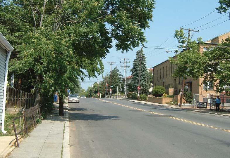
2 THE COMMUNITY Brookland, located in NE Washington DC with 12th Street as its central corridor between Michigan and Rhode Island Avenues, is a neighborhood of rolling hills, with tree-lined streets, eclectic architecture, and a rich artistic and intellectual legacy. It offers many personalities that range from residential neighborhoods and institutional anchors like Catholic University (CUA) to lively commercial areas. Like many communities, Brookland also displays some of the most challenging problems associated with vehicular movement, pedestrian safety, and streetscape aesthetics. Recent construction of the nearby Brentwood Road Shopping Center has resulted in significant increases in pedestrian and vehicular traffic, and a lack of maintenance and safety is evident, resulting in increased burglaries of the commercial businesses. Examples of Brookland s existing streetscape conditions.


3 CONNECTIVITY Deficient vehicular, bicycle and pedestrian connectivity to and from the surrounding neighborhoods results in less business for 12th Street s commercial core than would be expected from a theoretically strong customer base. The Metro and heavy rail tracks worsen this scenario by separating Brookland and the areas to the west. The great advantage of having the Brookland/CUA Metro Station in close proximity to 12th Street is negated by virtually no visible pedestrian connection or way-finding signs to Brookland.


 provided additional input and aided in the formation of the")


4 PUBLIC PARTICIPATION The first step in unlocking 12th Street s potential to the liking of the community s stakeholders, was the instigation of an extensive public participation process. Through a series of meetings, workshops/ charettes, and community walks, representatives from the residential and business community, neighborhood institutions, elected officials and agencies had the opportunity to be heard and get involved. Collaboration with WMATA, utility companies, ANCs, Brookland Community Development Corporation (CDC), 12th Street Main Street, students and faculty from CUA, and Study/Technical Advisory Committees (SAC/TAC) provided additional input and aided in the formation of the following study goals: The study team created an interactive project website as a tool for the public and agencies to follow the progress, find meeting notices, minutes, and links to relevant District resources, download draft documents, and provide comments. (access through Reduce traffic congestion and travel speeds. Improve parking supply. Promote pedestrian safety. Reduce impact of truck traffic on residential neighborhoods. Enhance transit, bicycle, and pedestrian access and connectivity. Improve the public realm, enhance the sense of place and highlight the unique character of the community. Photos of workshops & community walks.
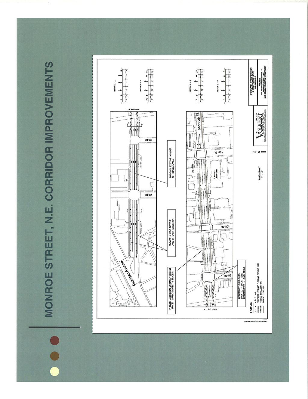
5 EXISTING CONDITIONS Concurrent with the outreach efforts, the team embarked on an extensive existing conditions assessment as the canvas for developing transportation and public realm recommendations. Strengths and weaknesses were identified and condition levels for sidewalks, street trees, lighting, utilities, and street furnishings were documented in graphic, tabular and textual format (See example to the right: mapping of street tree conditions). The transportation infrastructure analysis included descriptions of parking, roadway surfaces, pavement markings and signing, street lighting and traffic signal operations, traffic and pedestrian counts, collisions, truck circulation, transit and bicycle service. (Page 90 of report)

6 RECOMMENDATIONS Recommendations for transportation and streetscape improvements are a culmination of active participation by and input from community representatives, assistance from DDOT-TPPA, and the efforts of the study team. Where applicable, transportation related recommendations provided the basis for public realm improvements; they are organized by sub-districts to allow for context-sensitive design (see next slide). A set of recommended streetscape improvements is provided for each of the seven sub-districts, incorporating an easyto-use reference system with links to a Streetscape Elements Library. This system was developed to enable the reader to find in-depth and technical information about the recommendations while keeping the central part of the document comprehensible and concise. Right: Content of Streetscape Elements Library (Page 140 of report)
7 Sub-District Plan (Pages of report)


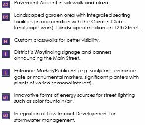
8 The Theme: Sustainability An overall theme of sustainability with social, environmental, and economic aspects unifies the sub-districts without compromising their individuality, appearance and function. By promoting multi-modal transportation and enhancing the streetscape in an environmentally sensitive manner, creating appealing public spaces and vibrant commercial areas, it is intended to encourage the stakeholders stewardship of the public realm and build a socially responsible, enjoyable, sustainable, and economically viable neighborhood. FIVE UNIFYING STREETSCAPE ELEMENTS have been identified to reflect the theme and nature of Brookland s unique neighborhood. If applied contiguously along 12th Street, these elements can tie the corridor s different zones and uses together and create an aesthetically pleasing, safe and vibrant Main Street. (Pages of report)

9 (Pages of report) Sub-district specific recommendations (1)

10 (Pages of report) Sub-district specific recommendations (2)
")

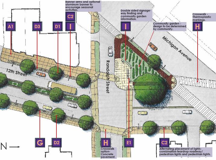
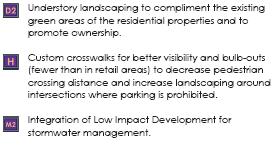
11 (Pages of report) Sub-district specific recommendations (3a)

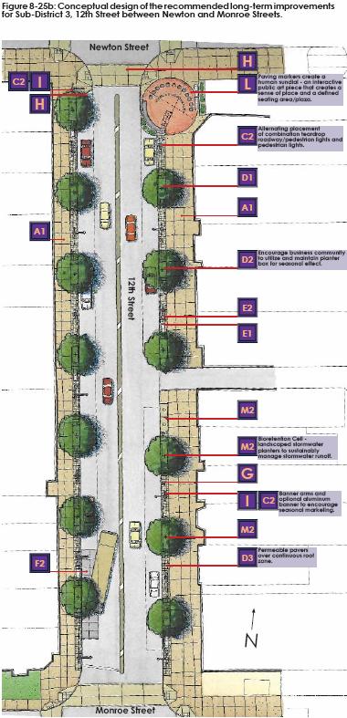
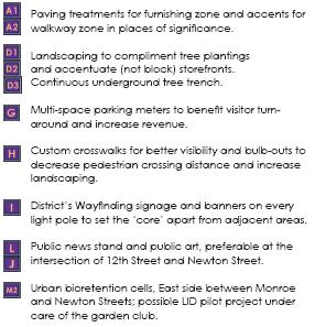
12 (Pages of report) Sub-district specific recommendations (3b)

")

13 (Pages of report) of report) Sub-district specific recommendations (4)

14 (Pages of report) Sub-district specific recommendations (5)
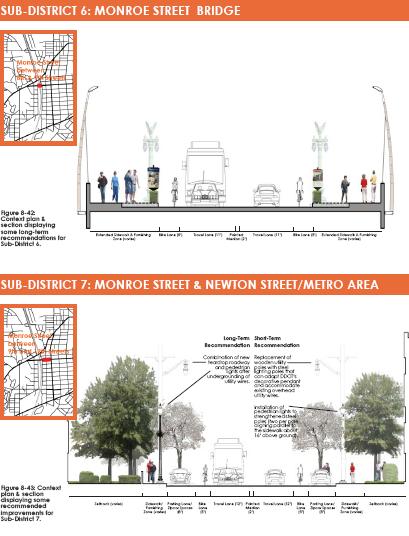
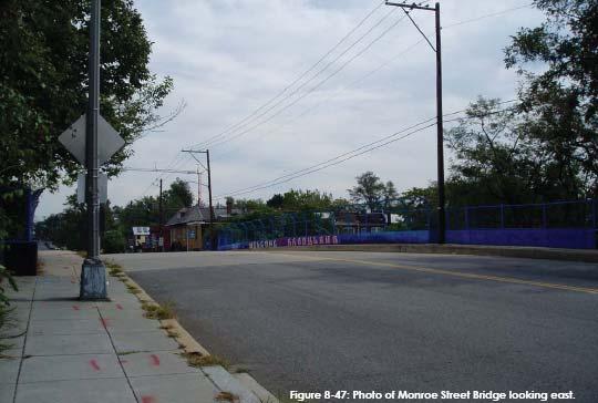
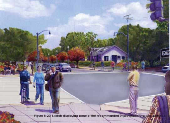
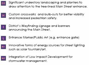
15 Sub-district specific recommendations (6 & 7a) (Pages of report)
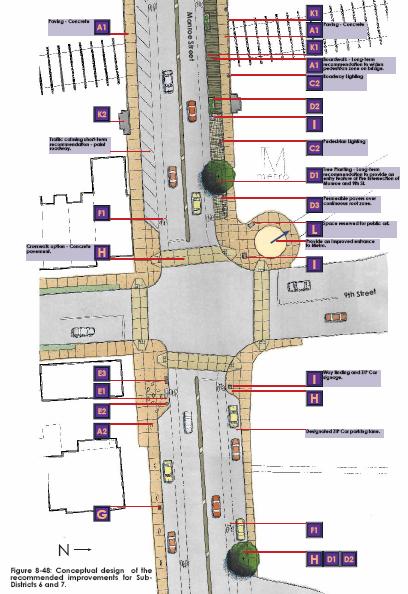
16 Sub-district specific recommendations (6 & 7b) (Pages of report)

 (Pages 141 &")
17 Example of Streetscape Elements Library (1) (Pages 141 & 144 of report)

 (Pages 145 &")
18 Example of Streetscape Elements Library (2) (Pages 145 & 153 of report)

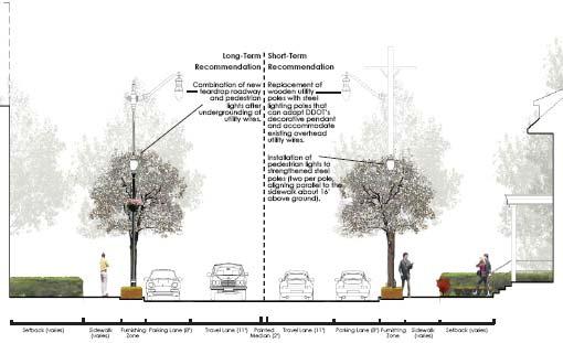
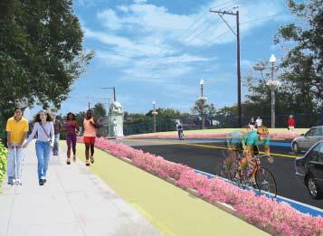
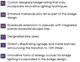
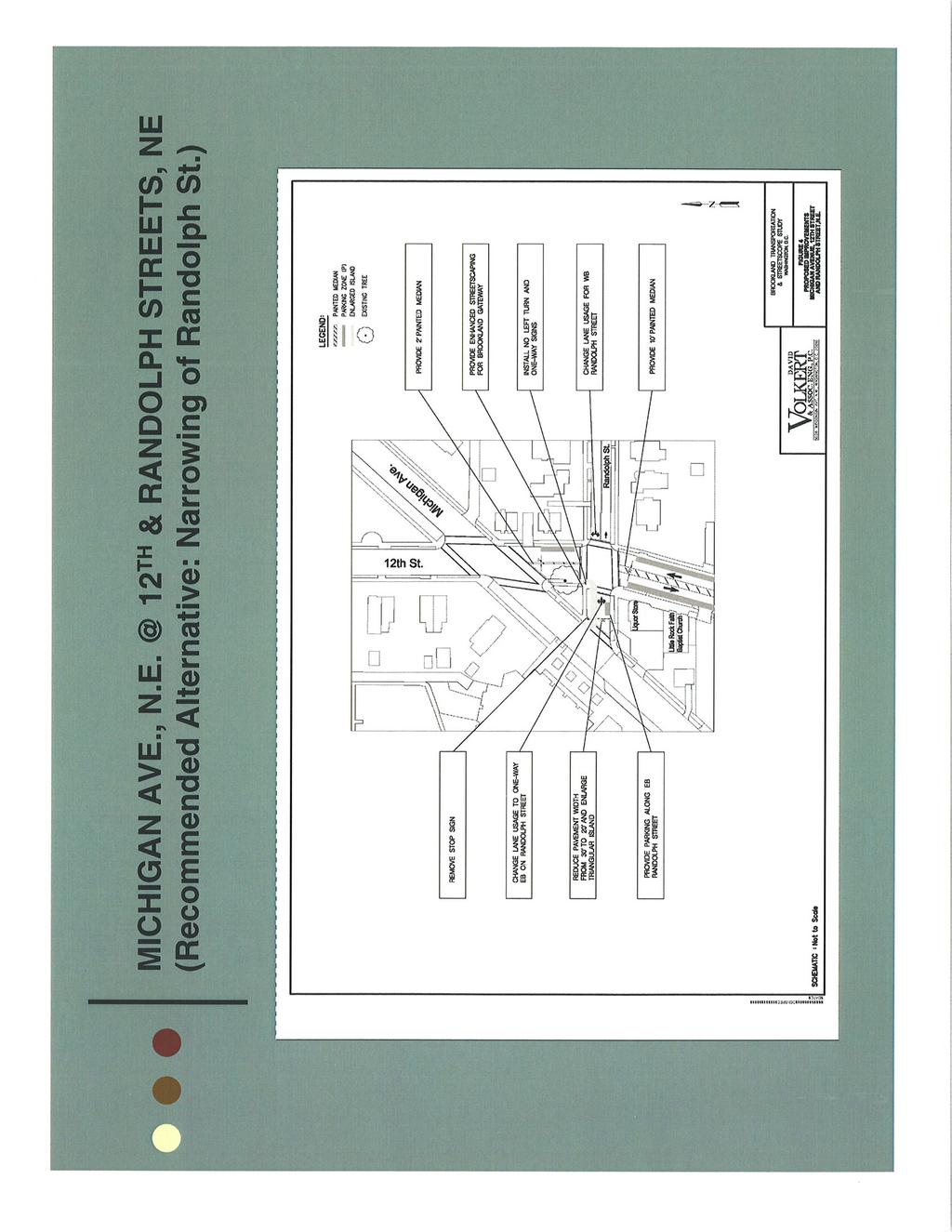
19 IMPLEMENTATION Transportation Related Long-Term Recommendations The recommendations contained in the report shall provide the District s agencies, residents, private developers and other stakeholders with tools to effectively improve the transportation infrastructure and streetscape design. In accordance with the client s time lines, the team identified short-and long-term improvements and a public investment and implementation strategy, including potential sources of funding. Streetscape Related Long-Term Recommendations TRAFFIC SIGNALS: The existing traffic signals should be upgraded to conform with the latest design guidelines and practices. Signal modifications are necessary at virtually all signalized intersections within the study area and pedestrian phasing and pedestrian signal heads should be added at signalized intersections where they do not currently exist. [M] TIMING/PHASING: Install updated traffic signal timing with appropriate phasing adjustments to reflect current traffic conditions and improve traffic operations. [M] INTERSECTION & ROADWAY MODIFICATIONS: In line with the public realm improvements, provide clearly marked parking, bike and vehicular travel lanes, safe pedestrian crossings, a painted or landscaped median; widths vary by location. CAR SHARING: In an effort to promote car sharing, considerations should be given to expanding the Zipcar/Flexcar program within Brookland area. [M] NORTHERN GATEWAY: Due to the complexity of the traffic operations and safety issues at the intersections of Michigan Avenue/12th Street, N.E., it is recommended that this location be studied in greater detail. A possible conceptual layout for intersection improvements is included in chapter 8.5. [P, M, B] TRUCK PROHIBITION SIGNS: Provide consistent truck prohibition signs for the Brookland area. [M] SMALL TRUCKS: Encourage local businesses to utilize smaller trucks, if possible, for delivery of supplies and materials. [M] LOADING ZONES: Provide additional designated loading zones within the 12th Street, N.E. corridor to facilitate delivery services for area businesses. [M] UNDERGROUNDING OF UTILITY LINES. [B,M,P,PT] LIGHTING: Install new decorative roadway and pedestrian level lights to provide higher levels of illumination and beautify the streetscape. [P] INTERSECTION MODIFICATIONS: In line with the transportation improvements, provide safe pedestrian crossings and more green space around intersections. This may include bulb-outs and stamped concrete crosswalks. [P] WALKWAYS: Install new exposed aggregate concrete sidewalks along 12th and Monroe Streets and add sidewalks along Newton Street to provide pedestrian-friendly Metro station access. Incorporate sidewalk accents where appropriate. [P] ADA RAMPS: Install or upgrade ADA ramps to accommodate persons with disabilities to meet current DDOT design standards, which adhere to ADA guidelines. [P] FURNISHING ZONE: Install new curb and cutter and permeable walkable surface treatments; place decorative street furnishings in the furnishing zone, including seating, bicycle racks, and bollards, and add trash receptacles where necessary. [P] BRIDGE IMPROVEMENTS: Widen sidewalks, add bike lanes and provide buffer zones using landscaping, light fixtures and furniture. [B,M,P,PT] MULTI-SPACE PARKING: Install multi-space parking meters along the commercial areas of 12th Street, coordinating the spacing with light poles and trees. [M] LANDSCAPING: Plant flowering trees and understory plantings along 12th and Monroe Streets to define the public realm. Install landscaping within the median. [B,M,P,PT] PUBLIC ART/ENTRANCE MARKERS: Create and install larger public art and/or entrance markers in cooperation with the community. [B,M,P,PT] LID: As part of the resurfacing project, incorporate Low Impact Development Techniques along curb and gutter and bioretention cells within landscaped areas. [B,M,P,PT] Discuss the following items with Washington Metropolitan Area Transit Authority (WMATA), and, if applicable, with the District Office of Planning (OP) [B,P,PT]: + Installation of appropriate directional signs [P, PT] + New and expanded bike racks [B] + Access [P, PT] + Bus shelters [PT] (Pages of report)
20
21

22
23
24
MARTIN LUTHER KING JR. WAY
 OCTOBER 2011 40 Vision and Goals The Martin Luther King, Jr. Way Illustrative Master Plan that follows has been developed through a process of community involvement. It expresses a long term vision for
Vision: Traditional hamlet with an attractive business/pedestrian friendly main street connected to adjacent walkable neighborhoods
 N D. Focus Area II Vision: Traditional hamlet with an attractive business/pedestrian friendly main street connected to adjacent walkable neighborhoods Transit Road Focus Area II is located in the Hamlet
UDC Street Cross Sections
 UDC Street Cross Sections Local Street - Downtown Local Street Mountable Curb Local Street Vertical Curb Alley Major Arterial Minor Arterial Residential Lane Residential Collector Residential Collector
Proposed. City of Grand Junction Complete Streets Policy. Exhibit 10
 Proposed City of Grand Junction Complete Streets Policy Exhibit 10 1 City of Grand Junction Complete Streets Policy Vision: The Complete Streets Vision is to develop a safe, efficient, and reliable travel
14 TH STREET TRANSPORTATION & STREETSCAPE DESIGN STUDY PLAN B PLAN B TRANSPORTATION & STREETSCAPE RECOMMENDATIONS
 14 TH STREET TRANSPORTATION & STREETSCAPE DESIGN STUDY PLAN B PLAN B TRANSPORTATION & STREETSCAPE RECOMMENDATIONS 141 Symbols Recommendations - Southern End of 14th Street Study Area Streetscape Each icon
A CHANGING CITY. of Edmonton, it is essential that it reflects the long-term vision of the City.
 A CHANGING CITY By the year 2040, Edmonton will be home to more than 1 million people. To accommodate growth and support a healthy and compact city, we need a new approach to development/redevelopment
APPROVE A RESOLUTION ADOPTING A COMPLETE STREETS POLICY
 STAFF REPORT MEETING DATE: September 13, 2016 TO: FROM: City Council Bob Brown, Community Development Director Russ Thompson, Public Works Director Patrick Filipelli, Management Analyst 922 Machin Avenue
S T A T I O N A R E A P L A N
 The Circulation and Access Plan describes vehicle, pedestrian, and transit improvements recommended within the Concept Plan. In order to create and sustain a vibrant business district that provides pedestrian-friendly
Make Lincoln Highway an economically vibrant corridor that is safe, efficient, and beautiful for local residents and visitors.
 Lincoln Highway Streetscape Plan Stakeholder Workshop #2 Handout Contents Introduction and Project Vision Planning Principles Specific Recommendations including a Proposed Typical Roadway Section Renderings
Complete Streets. Designing Streets for Everyone. Sarnia
 Complete Streets Designing Streets for Everyone Sarnia Complete Streets ~ Sarnia ~ 2018 Introduction Our City is made up of a network of streets that we use to go for a walk, cycle to work, drive to the
CONNECTIVITY PLAN. Adopted December 5, 2017 City of Virginia Beach
 CONNECTIVITY PLAN Adopted December 5, 2017 City of Virginia Beach CONTENTS 1.0 Background & Purpose... 2 2.0 Existing Inventory & Analysis... 3 ViBe District Existing Walking Conditions... 4 3.0 ViBe District
PUBLIC REALM MASTER PLAN
 WESTSHORE BUSINESS DISTRICT PUBLIC REALM MASTER PLAN MASTER PLAN COMMITTEE MEETING MARCH 20, 2013 WESTSHORE BUSINESS DISTRCT PUBLIC REALM MASTER PLAN MACRO-SCALE CONCEPT: A PUBLIC REALM FRAMEWORK DEFINED
o n - m o t o r i z e d transportation is an overlooked element that can greatly enhance the overall quality of life for the community s residents.
 N o n - m o t o r i z e d transportation is an overlooked element that can greatly enhance the overall quality of life for the community s residents. 84 Transportation CHAPTER 11 INTRODUCTION Transportation
STONY PLAIN ROAD STREETSCAPE
 Jasper Place Revitalization Strategy: Vision The people involved in the Jasper Place Revitalization Strategy envision: Goal 1: Feeling safe in our community Create a community where feeling safe is common--where
Brooklyn Boulevard (County Road 152) Reconstruction Project Phase I. OPEN HOUSE June 20, 2017
 Reconstruction Project Phase I. OPEN HOUSE June 20, 2017") Brooklyn Boulevard (County Road 152) Reconstruction Project Phase I OPEN HOUSE June 20, 2017 Brooklyn Boulevard (County Road 152) Phase I Project Partners Project Lead Other Project Partners include Brooklyn
Brooklyn Boulevard (County Road 152) Reconstruction Project Phase I OPEN HOUSE June 20, 2017 Brooklyn Boulevard (County Road 152) Phase I Project Partners Project Lead Other Project Partners include Brooklyn
Non-Motorized Transportation 7-1
 Non-Motorized Transportation 7-1 Transportation facilities no longer mean just accommodating a vehicle powered by a combustion engine. Pedestrian and non-motorized facilities are important modes of travel
APPENDIX A: Complete Streets Checklist DRAFT NOVEMBER 2016
 APPENDIX A: Complete Streets Checklist DRAFT NOVEMBER 2016 Complete Streets Checklist MetroPlan Orlando s Complete Streets Checklist is an internal planning tool for staff to further implementation of
5 CIRCULATION AND STREET DESIGN
 5 CIRCULATION AND STREET DESIGN This chapter describes circulation and streetscape improvements proposed for the Northwest Chico Specific Plan Area. It includes detailed design specifications for existing
Omaha s Complete Streets Policy
 Omaha s Complete Streets Policy (Adopted August 2015) VISION To create great places and enhance our quality of life, the City of Omaha will provide safe, accessible streets for all users. Complete Streets
Environment and Public Works Committee Presentation
 Mixed Use Centers Complete Streets Guidelines Project Environment and Public Works Committee Presentation December 10, 2008 Project Objectives: Conduct an inter-departmental and agency process to study
San Jose Transportation Policy
 San Jose Transportation Policy Protected Intersections in LOS Policies to Support Smart Growth Presented by: Manuel Pineda City of San Jose Department of Transportation Bay Area Map San Francisco Oakland
STEERING COMMITTEE MEETING June 17, Streetscape Overview Burlington Comprehensive Master Plan
 STEERING COMMITTEE MEETING June 17, 2015 Streetscape Overview Burlington Comprehensive Master Plan 1 Introduction Slide This slide show was presented to the Burlington Steering Committee on June 17, 2015
Bicycle Master Plan Goals, Strategies, and Policies
 Bicycle Master Plan Goals, Strategies, and Policies Mobilizing 5 This chapter outlines the overarching goals, action statements, and action items Long Beach will take in order to achieve its vision of
El Camino Real Specific Plan. TAC/CAC Meeting #2 Aug 1, 2018
 El Camino Real Specific Plan TAC/CAC Meeting #2 Aug 1, 2018 Land Use Alternatives Goals and Tradeoffs Parks & open space Housing Retail & services Civic spaces Parking Community gathering spaces 3 Alternatives
PEDESTRIAN ACTION PLAN
 ATTACHMENT 2 CITY OF SANTA MONICA PEDESTRIAN ACTION PLAN CITY OF SANTA MONICA PEDESTRIAN ACTION PLAN This page intentionally left blank EXECUTIVE SUMMARY CHAPTER 1 EXECUTIVE SUMMARY Setting the Stage
Ocean Park Boulevard Green Street Project Alternatives & Trade Offs
 Planning Commission March 4, 2009 Ocean Park Boulevard Green Street Project Alternatives & Trade Offs Purpose of Tonight s Meeting Review concept plans and options Provide input on alternatives and trade-offs
City of Seattle Edward B. Murray, Mayor
 City of Seattle Edward B. Murray, Mayor Department of Transportation Scott Kubly, Director Eastlake Community Council 117 E Louisa St. #1 Seattle, WA 98102-3278 January 28, 2016 RE: Roosevelt to Downtown
Why invest in the 1 Street S.W. Corridor?
 Why invest in the 1 Street S.W. Corridor? This project is an investment in the Beltline Community and Calgary s economy. It is anticipated that The City s investment along this corridor will help with
Executive Summary Route 30 Corridor Master Plan
 Route Corridor Master Plan Project Overview The Route Corridor Master Plan is a coordinated multimodal transportation and land use plan for the entire stretch of Route through East Whiteland Township,
Welcome to the Quebec Alternatives Analysis Public Meeting
 Welcome to the Public Meeting Please sign in. Public Comment Please fill out a comment card and tell us what you think. Check back or comment any time at: www.quebecalternatives.com Project Area Technical
WHITE STREET/ ENGLISH PLAZA STREETSCAPE IMPROVEMENT PROJECT
 WHITE STREET/ ENGLISH PLAZA STREETSCAPE IMPROVEMENT PROJECT 1 Project Goals 1 Improved Safety: Lighting, Multi-Modal Circulation, Emergency Access, Tripping Hazards; Stormwater 4 Environmental Performance:
MAKE YOUR PLACE IN CHANNELSIDE
 MAKE YOUR PLACE IN CHANNELSIDE INTRODUCTION PROJECT LIMITS Channelside Drive from Cumberland Ave to Kennedy Boulevard EXISTING CONDITIONS EXISTING CONDITIONS CHANNELSIDE DRIVE FROM E. CUMBERLAND AVENUE
Item to be Addressed Checklist Consideration YES NO N/A Required Description Complete Streets Guidelines
 Passaic County Complete Streets Checklist - Concept Development Project Name Item to be Addressed Checklist Consideration YES NO N/A Required Description Complete Streets Guidelines Existing Plans Have
Austin Avenue Bridges Project. Public Meeting Summary
 Austin Avenue Bridges Project Public Meeting Summary June 29, 2016 Red Table Safety and Connectivity Notes: 1. Would like to see forensic report evaluations 2. What is the lifespan? 3. Extend safety considerations
Community Meeting February 27, 2007 Dorchester Avenue Transportation & Streetscape Improvements Action Plan February 27, 2007
 Community Meeting Tonight s Agenda 6:00 Introductions South Boston/Dot Ave Improvement Study Background 6:15 Consultant Introductions Review of Scope and Schedule Review of Proposed Corridor Wide Guidelines
4 GENERIC COST ESTIMATING TOOL
 4 GENERIC COST ESTIMATING TOOL Table 4-1 presents a generic cost estimating tools that can serve as a conceptual planning tool for local jurisdictions to estimate the costs of pedestrian improvements.
PEDESTRIAN CIRCULATION & STREETSCAPE DESIGN
 CHAPTER 4 Chapter 4 Pedestrian Circulation & Trails PEDESTRIAN CIRCULATION & STREETSCAPE DESIGN In recent years, the City has constructed new sidewalks and enhanced existing ones in the downtown with brick
Fulton Market Streetscape
 Fulton Market Streetscape Ogden Avenue to Halsted Street Public Meeting Recommended Improvements December 10th, 2014 Meeting Purpose and Goals Present Existing Conditions Community Input and Charrette
MAG Town of Cave Creek Bike Study Task 6 Executive Summary and Regional Significance Report
 Page 1 MAG Town of Cave Creek Bike Study Task 6 Executive Summary and Regional Significance Report August 1, 2012 MAG Project #481 Page 2 Task 6 Executive Summary and Regional Significance Report Introduction
CITY OF BLOOMINGTON COMPLETE STREETS POLICY
 CITY OF BLOOMINGTON COMPLETE STREETS POLICY POLICY OBJECTIVE: The City of Bloomington will enhance safety, mobility, accessibility and convenience for transportation network users of all ages and abilities,
Ann Arbor Downtown Street Plan
 1 Ann Arbor Downtown Street Plan Public Workshop #1 We know that. 2 Public right-of-way (streets, sidewalks, and alleys) make up 30% of the total District area of downtown. Streets need to provide mobility
ROUTE 81 CORRIDOR STUDY DESIGN CONCEPTS
 RT 81 Corridor Study CLINTON ROUTE 81 CORRIDOR STUDY DESIGN CONCEPTS View north on High Street, with potential improvements to the streetscape Draft Recommendations November 8 th, 2018 TOWN OF CLINTON
CITY OF COCOA BEACH 2025 COMPREHENSIVE PLAN. Section VIII Mobility Element Goals, Objectives, and Policies
 CITY OF COCOA BEACH 2025 COMPREHENSIVE PLAN Section VIII Mobility Element Goals, Objectives, and Policies Adopted August 6, 2015 by Ordinance No. 1591 VIII MOBILITY ELEMENT Table of Contents Page Number
Streetscape: Core Shopping District
 Streetscape: Core Shopping District DRAFT DRAFT DRAFT May 00 Core Shopping District: Phase Blue Island s Core Shopping District is located along Western Avenue, between Grove and Union Streets. Streetscape
Richmond Connects Visioning Update
 Richmond Connects Visioning Update To date there have been four elements of the visioning process: Vision20 Night at Byrd Theatre on May 3rd Advisory Committee Meeting on May 12 th Public Visioning Workshop
Aurora Urban Street Standards For Transit Oriented Developments and Urban Centers
 Aurora Urban Street Standards For Transit Oriented Developments and Urban Centers I. Purpose These standards will be applied to create a safe, comfortable, pleasant and pedestrian-friendly multi-modal
Illustrated Principles of Good Planning
 Illustrated Principles of Good Planning The Miami 21 Zoning Code incorporates time-tested planning principles into the zoning regulations of our City. These are principles that make for better neighborhoods,
Exhibit 1 PLANNING COMMISSION AGENDA ITEM
 Exhibit 1 PLANNING COMMISSION AGENDA ITEM Project Name: Grand Junction Circulation Plan Grand Junction Complete Streets Policy Applicant: City of Grand Junction Representative: David Thornton Address:
Bicycle and Pedestrian Advisory Committee (BPAC) November 21, 2013
 November 21, 2013") Bicycle and Pedestrian Advisory Committee (BPAC) November 21, 2013 OVERALL LAND USE CONCEPT Overall Broadway Valdez District: 95.5 acres (35.1 acres right-of ways + 60.4 acres developable land) Plan Subareas:
Bicycle and Pedestrian Advisory Committee (BPAC) November 21, 2013 OVERALL LAND USE CONCEPT Overall Broadway Valdez District: 95.5 acres (35.1 acres right-of ways + 60.4 acres developable land) Plan Subareas:
CURBSIDE ACTIVITY DESIGN
 5 CURBSIDE ACTIVITY DESIGN This chapter provides design guidance for separated bike lanes adjacent to curbside activities including parking, loading and bus stops. Typical configurations are presented
Making Phoenix Streets Complete. City of Phoenix Complete Streets Initiative
 Making Phoenix Streets Complete City of Phoenix Complete Streets Initiative City of Phoenix Planning Commission March 2014 Presentation Outline What are Complete Streets? Benefits of Complete Streets Complete
Agenda. Overview PRINCE GEORGE S PLAZA METRO AREA PEDESTRIAN PLAN
 PRINCE GEORGE S PLAZA METRO AREA PEDESTRIAN PLAN May 28, 2008 Agenda Welcome and introductions Project overview and issue identification Planning context and strengths Design challenges and initial recommendations
RESOLUTION NO A RESOLUTION OF THE CITY COUNCIL OF THE CITY OF MENLO PARK ADOPTING A COMPLETE STREETS POLICY
 RESOLUTION NO. 6123 A RESOLUTION OF THE CITY COUNCIL OF THE CITY OF MENLO PARK ADOPTING A COMPLETE STREETS POLICY WHEREAS, the term Complete Streets describes a comprehensive, integrated transportation
EXECUTIVE SUMMARY. Vision
 Vision Walking and bicycling in Salt Lake City will be safe, convenient, comfortable, and viable transportation options that connect people to places, foster recreational and economic development opportunities,
TOWN OF PORTLAND, CONNECTICUT COMPLETE STREETS POLICY
 TOWN OF PORTLAND, CONNECTICUT COMPLETE STREETS POLICY I. VISION, GOALS & PRINCIPLES VISION To improve the streets of Portland making them safer and more accessible for all users including pedestrians,
Ocean Park Boulevard Green Street Project Community Workshop
 Ocean Park Boulevard Green Street Project Community Workshop 2.2.10 Project Objectives Community Priority: reclaim OPB for public open space. Build upon LUCE principles; neighborhood enhancement, connectivity,
THE ALAMEDA CONCEPT DESIGN COMMUNITY MEETING 3. A Plan for The Beautiful Way JANUARY 28, 2010
 CONCEPT DESIGN COMMUNITY MEETING 3 JANUARY 28, 2010 AGENDA INTRODUCTION COMMUNITY INPUT ROADWAY STUDIES STREETSCAPE DESIGN STATIONS DISCUSSION SUMMARY AND DISCUSSION NEXT STEPS CLOSE INTRODUCTION SCHEDULE
Living Streets Policy
 Living Streets Policy Introduction Living streets balance the needs of motorists, bicyclists, pedestrians and transit riders in ways that promote safety and convenience, enhance community identity, create
Tonight is for you. Learn everything you can. Share all your ideas.
 Strathcona Neighbourhood Renewal Draft Concept Design Tonight is for you. Learn everything you can. Share all your ideas. What is Neighbourhood Renewal? Creating a design with you for your neighbourhood.
RESOLUTION NO ?? A RESOLUTION OF THE CITY OF NEPTUNE BEACH ADOPTING A COMPLETE STREETS POLICY
 RESOLUTION NO. 2018-?? A RESOLUTION OF THE CITY OF NEPTUNE BEACH ADOPTING A COMPLETE STREETS POLICY WHEREAS, safe, convenient, and accessible transportation for all users is a priority of the City of Neptune
complete streets design and construction standards public primer City of Edmonton
 complete streets design and construction standards public primer City of Edmonton introduction Complete Streets are streets for everyone: people who walk, wheel, bike, take transit, or drive. They are
COWETA HIGH SCHOOL AND EAST HIGHWAY 51
 COWETA HIGH SCHOOL AND EAST HIGHWAY 51 Lack of sidewalks along Ben Lumpkin Rd. Lack of crosswalks and ramps at intersection. Hwy 51 is wide to cross as a pedestrian. No ADA compliance or connection to
Paoli Road Improvement Feasibility Study
 Paoli Road Improvement Feasibility Study & Public Participation Project March 24, 2015 Prepared for: Tredyffrin Township Prepared by: McMahon Associates, Inc. with Town Planning Partnership, LLC Glackin
City of Wilsonville 5 th Street to Kinsman Road Extension Project
 City of Wilsonville 5 th Street to Kinsman Road Walking Tour & Neighborhood Workshop Summary Report Public Outreach Overview On July 18 th, 2017, the City of Wilsonville hosted a neighborhood walking tour
WALKNBIKE DRAFT PLAN NASHVILLE, TENNESSEE EXECUTIVE SUMMARY NASHVILLE, TENNESSEE
 NASHVILLE, TENNESSEE EXECUTIVE SUMMARY Executive Summary A world-class multi-modal transportation system is essential to a vibrant city and better quality of life. -Mayor Barry The WalknBike plan aims
Cross Street Corridor Non-Motorized Enhancement Project Project Description
 Cross Street Corridor Non-Motorized Enhancement Project Project Description A cooperative study of the Cross Street neighborhood was completed in May 2002 by the City of Ypsilanti, the Depot Town Downtown
Ocean Park Boulevard Streetscape Improvement Project Alternatives & Trade Offs
 City Council Study Session January 27, 2009 Ocean Park Boulevard Streetscape Improvement Project Alternatives & Trade Offs Scope of Work Purpose of Tonight s Meeting Review work to date and direct staff
NM-POLICY 1: Improve service levels, participation, and options for non-motorized transportation modes throughout the County.
 Transportation PRINCE WILLIAM COUNTY 2008 COMPREHENSIVE PLAN NON-MOTORIZED PLAN CONTENTS Goals, Policies, and Action Strategies Table 4 (Bike Facility Classifications and Descriptions) Table 5 (Bike Facility
FONTAINE AVENUE STUDY Final Report
 FONTAINE AVENUE STUDY Final Report March 28, 2005 FONTAINE AVENUE STUDY City of Charlottesville March 28, 2005 Renaissance Planning Group Kenneth Schwartz, FAIA, AICP Director of Design Leigh Wilkerson,
Chapter 4: Funding and Implementation
 Chapter 4: Funding and Implementation 83 84 Cost Estimating Cost estimating is an iterative process. When a project is in the conceptual stage, preliminary cost estimates are also provided conceptually,
AMATS Complete Streets Policy
 AMATS Complete Streets Policy Table of Contents: Section 1. Definition of Complete Streets Section 2. Principles of Complete Streets Section 3. Complete Streets Policy Section 4. Consistency Section 5.
12/4/2016 VIA . RE: Grocery Outlet Del Paso (DR16-328)
") 12/4/2016 VIA EMAIL Ethan Meltzer, Assistant Planner City of Sacramento Community Development Department 300 Richards Blvd, 3 rd Floor Sacramento, CA 95811 RE: Grocery Outlet Del Paso (DR16-328) Dear Mr.
12/4/2016 VIA EMAIL Ethan Meltzer, Assistant Planner City of Sacramento Community Development Department 300 Richards Blvd, 3 rd Floor Sacramento, CA 95811 RE: Grocery Outlet Del Paso (DR16-328) Dear Mr.
NJDOT Complete Streets Checklist
 Background The New Jersey Department of Transportation s Complete Streets Policy promotes a comprehensive, integrated, connected multi-modal network by providing connections to bicycling and walking trip
City of Darlington Beautification Report
 City of Darlington Beautification Report Approved by the City of Darlington Beautification Board February 2016 The New Downtown Darlington has seen many changes during the past decade with the rehabilitation
Elm Street Business District: Streetscape and Signage Plan
 Winnetka Preliminary Streetscape & Signage Village Council Presentation 1 Elm Street Business District: Streetscape and Signage Plan VILLAGE OF WINNETKA DOWNTOWN MASTER PLAN VILLAGE COUNCIL PRESENTATION
Mission-Geneva Transportation Study Community Workshop 2 July 8, 2006
 Community Workshop 2 July 8, 2006 Small Group Workbook 1 Basic Improvements on Mission Street Streetscape. Pedestrian-scale lighting; landscaping; community art on utility boxes; more (possibly unique)
5 Circulation & Parking
 5 Circulation & Parking Downtown Parking & Circulation Strategy. Downtown Wayne has a somewhat disconnected system of local public streets to connect downtown with the residential neighborhoods, and primary
19th St/Oakland Station Modernization
 19th St/Oakland Station Modernization BART is advancing the second round of the Station Modernization Program, which will invest resources into the existing core stations and surrounding areas to advance
CONNECTING PEOPLE TO PLACES
 CONNECTING PEOPLE TO PLACES 82 EAST BENCH MASTER PLAN 07 Introduction The East Bench transportation system is a collection of slow moving, treelined residential streets and major arteries that are the
Table #6 VISION CHARACTERISTICS
 Table #6 VISION White Flint is a place to live, work, play, shop, and walk with sufficient density to encourage quality redevelopment. Vibrant streets and consistent streetscapes are important. CHARACTERISTICS
Chapter 7. Transportation. Transportation Road Network Plan Transit Cyclists Pedestrians Multi-Use and Equestrian Trails
 Chapter 7 Transportation Transportation Road Network Plan Transit Cyclists Pedestrians Multi-Use and Equestrian Trails 7.1 TRANSPORTATION BACKGROUND The District of Maple Ridge faces a number of unique
TRAVEL PLAN: CENTRAL EUROPEAN UNIVERSITY CAMPUS REDEVELOPMENT PROJECT TRAVEL PLAN. Central European University Campus Redevelopment Project.
 TRAVEL PLAN Central European University Campus Redevelopment Project Page 1 Table of Contents Introduction... 3 Background... 7 Building Users... 7 Transportation in Community Consultation... 7 Summary
Lawrence Avenue Streetscape Concepts August 30, 2011
 Lawrence Avenue Streetscape Concepts August 30, 2011 Neighborhood Context Phase II: River to Western Ave. Phase I: Western Ave. to Clark St. Key Map Lawrence Ave. Existing Streetscape Conditions East of
5. Pedestrian System. Accomplishments Over the Past Five Years
 5. Pedestrian System Accomplishments Over the Past Five Years The Alamo Area Metropolitan Planning Organization (MPO) and its partner agencies recognize the importance of improving pedestrian mobility.
Martha Coello, Fairfax County DOT Jeffrey Hermann, Fairfax County DOT Abi Lerner, VDOT. May 19, 2014
 Traforming Tyso From An Auto Oriented Activity Center Into a Multi-Modal Center Martha Coello, Fairfax County DOT Jeffrey Hermann, Fairfax County DOT Abi Lerner, VDOT May 19, 2014 2 11 miles to Dulles
Roadway Classification Design Standards and Policies. Pueblo, Colorado November, 2004
 Roadway Classification Design Standards and Policies Pueblo, Colorado November, 2004 Table of Contents Page Chapter 1. General Provisions 1.1 Jurisdiction 3 1.2 Purpose and Intent 3 1.3 Modification 3
Complete Streets for Niagara A working method to visualize the creation of a complete street June 20th, 2013
 Complete Streets for Niagara A working method to visualize the creation of a complete street June 20th, 2013 C O N T E N T S Introduction and background of the report What is a complete street? What can
Henderson Ave. Complete Streets Project
 Henderson Ave. Complete Streets Project Meeting Purpose To finalize conceptual components of project prior to proceeding with preliminary engineering www.dallascompletestreets.wordpress.com MeetingAgenda
REGIONAL BICYCLE AND PEDESTRIAN DESIGN GUIDELINES
 REGIONAL BICYCLE AND PEDESTRIAN DESIGN GUIDELINES November 16, 2011 Deb Humphreys North Central Texas Council of Governments Bicycle and Pedestrian Advisory Committee Snapshot of the Guide 1. Introduction
BETHEL ROAD AND SEDGWICK ROAD CORRIDOR STUDY
 DRAFT PLAN City Council Meeting August 14, 2017 STUDY AREA Sedgwick Corridor State Route 160, principal arterial with Class 3 access management designation, commuter and freight route, connection to SR
WELCOME. Thank you for joining us at the Second Public Workshop for the Carlsbad Pedestrian Master Plan. We look forward to receiving your feedback.
 City of Carlsbad Pedestrian Master Plan: WELCOME WELCOME Please Sign In Provide Input at Flip Charts Review Boards Presentation of Draft Plan Thank you for joining us at the Second Public Workshop for
COMPLETE STREETS POLICY Exhibit A to Ordinance
 CITY OF WENATCHEE COMPLETE STREETS POLICY Exhibit A to Ordinance 2016-24 Prepared and Reviewed By: City of Wenatchee Community & Economic Development Department City of Wenatchee Public Works Department
Chapter 3: Multi-Modal Circulation and Streetscapes
 CHAPTER 3: MULTI-MODAL CIRCULATION AND STREETSCAPES Chapter 3: Multi-Modal Circulation and Streetscapes Overview Streetscape improvements have already been completed for Depot Street between Main Avenue
HARRISON STREET/OAKLAND AVENUE COMMUNITY TRANSPORTATION PLAN
 HARRISON STREET/OAKLAND AVENUE Community Workshop #4: Draft Plan Review December 3, 2009 D E S I G N, C O M M U N I T Y & E N V I R O N M E N T INTRODUCTIONS Key Project Staff: Alisa Shen, Project Manager,
Walkability Audit Cities of Olympia, Tumwater and Lacey, Washington. Next Steps Memorandum September FINAL
 Walkability Audit Cities of Olympia, Tumwater and Lacey, Washington Memorandum September 2012 - FINAL 1. INTRODUCTION The U.S. Environmental Protection Agency (EPA) selected the Thurston Regional Planning
Fitting Light Rail through Well-established Communities
 Fitting Light Rail through Well-established Communities San Francisco 2008 Michael D. Madden Chief, Project Development, Maryland Transit Administration Project Setting Located inside the Capital Beltway
WELCOME. City of Eden Prairie West 70 th Street
 WELCOME City of Eden Prairie West 70 th Street Project Schedule Sep Oct Nov Dec Jan Feb Mar Apr May Jun Jul Aug >>> May WEST SEGMENT Concept Plan Fall 2014 Plan Development Winter 2014 Summer 2015 Construction
New Measure A Expenditure Categories DEFINITIONS OF ELIGIBLE EXPENDITURES Adopted March 8, 2007
 New Measure A Expenditure Categories DEFINITIONS OF ELIGIBLE EXPENDITURES Adopted March 8, 2007 City Street and County Road Maintenance Program The preservation and keeping of public street and road rights-of-way
SAFE STREETS FOR ALL. A Report to Land Use Committee on Street widths in Hunters Point Shipyard and Candlestick Point Developments
 SAFE STREETS FOR ALL A Report to Land Use Committee on Street widths in Hunters Point Shipyard and Candlestick Point Developments Background: Candlestick Point Hunters Point Shipyard Redevelopment Project
Pennsylvania Avenue (CR 484) Design Alternatives Study
 Design Alternatives Study") MEMORANDUM Pennsylvania Avenue (CR 484) Design Alternatives Study Prepared for: APRIL 2016 Prepared By TABLE OF CONTENTS Project Background... 2 Previous Concept... 2 Existing Conditions... 4 New Alternatives...
MEMORANDUM Pennsylvania Avenue (CR 484) Design Alternatives Study Prepared for: APRIL 2016 Prepared By TABLE OF CONTENTS Project Background... 2 Previous Concept... 2 Existing Conditions... 4 New Alternatives...