Martha Coello, Fairfax County DOT Jeffrey Hermann, Fairfax County DOT Abi Lerner, VDOT. May 19, 2014
|
|
|
- Brandon Lucas
- 6 years ago
- Views:
Transcription
1 Traforming Tyso From An Auto Oriented Activity Center Into a Multi-Modal Center Martha Coello, Fairfax County DOT Jeffrey Hermann, Fairfax County DOT Abi Lerner, VDOT May 19, 2014

2 2

3 11 miles to Dulles Airport 11 miles to Downtown DC 3


4 Early Tyso Tyso Today Image source: Fairfax County EDA 4

5 Metrorail expaion to Dulles Airport Policy of higher deity, mixed use development in activity centers Tyso is not sustainable as exists today 17,000 residents to 105,000 jobs 167,000 parking spaces 5

6 The Vision A livable urban center with: Trait-oriented development A variety of modes for trip making Fewer parking spaces Pedestrian and bicycle friendly streets A defined see of place throughout Tyso Residents to Jobs mix of 100,000/200,000 6


7 Grid of Streets Tyso Corner Fairfax County Rosslyn Ballston Corridor Arlington County 7

8 Grid of Streets CONCEPTUAL Classification Block Size Implementation 8
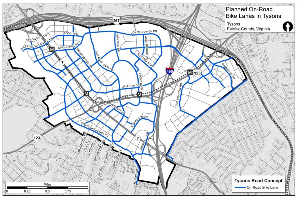
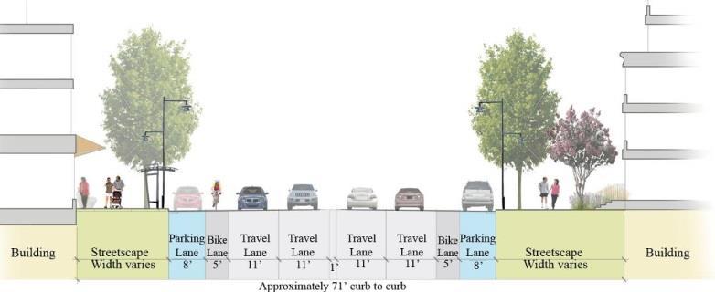
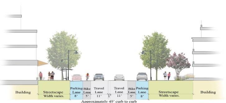
9 Multi-Modal Network Proposed Bicycle Network Cross Sectio 9


10 Initial Implementation Issues Pedestrian Facilities and Walkability Streetscape Bike Lanes and Parking 10


11 Memorandum of Agreement (MOA) and Traportation Design Standards for Tyso Set up to implement the design standards and address permitting and maintenance issues Developed by Fairfax County and VDOT with input from numerous stakeholders Purpose Develop a platform by which the Tyso Compreheive Plan could be implemented Facilitate the provision of traportation facilities that accommodate low speed roadways, pedestrian and bicycle facilities and trait services 11
12 Tyso Memorandum of Agreement VDOT Review and approve pla using Tyso Standards Accept new streets that conform to VDOT and Tyso Standards including phased and stubbed streets Issue permits for work to be performed on the streets Maintain existing and future streets that have been accepted into the primary and secondary system Respoibilities Fairfax County Eure that the development is in conformance with the Tyso Standards Eure that access rights are provided on any new street cotructed as a phased or stubbed street to allow for maintenance and public safety vehicles to turn around safely 12

13 Tyso MOA Non-Standard Features The placement of non-standard features within the ROW are subject to VDOT review for safety and operational issues Such facilities when approved shall be subject to the following: Non-standard feature should be allowed only through the issuance of a permit by VDOT Permittee may be Fairfax County or private developer VDOT is not obligated to cotruct, itall, operate, maintain or replace any such feature Features will be operated and maintained by the holder of the VDOT permit 13


14 Facilities Not Included in the Standards Employed by VDOT (Non-Standard Features in Attachment A of MOA) 1. Decorative and ornamental lighting features 2. Decorative and ornamental traffic signals 3. Special landscaping materials, planting beds, raised planters, street trees, root cell structures, tree cages and other landscaping materials 4. Special and decorative roadway or sidewalk paving 5. Special drainage features, underground storage and mechanical vault structures, and innovative drainage features such as rain garde (conceptual graphic examples shown in Attachment B of the MOA) 6. Special signage such as way finding sig 7. Street furniture such as benches, trash receptacles, kiosks 8. Bus shelters and other trait related facilities 9. Parking meters 10. Decorative, non-standard retaining walls 14
15 Memorandum of Agreement on Urban Standards for Tyso 1. Functional Classification and Right-of-Way Limits 2. Level of Service Standards 3. Design and Operating Speeds 4. Access Management 5. Lane Widths and On-Street Parking 6. Median Islands and Center Turn Lanes 7. Turn Lane Lengths 8. Horizontal Radius 9. Length of Vertical Curve 10. Design and Control Vehicles 11. Driveway Widths 12. Intersection Sight Distance 13. Multi-Modal Design Characteristics 14. Pedestrian Facilities 15. Bicycle Facilities 16. Utility Placement 15

16 Level of Service Standards (1) The minimum designated standard for NHS designated streets is D, while the standard in the Tyso Compreheive Plan is E. The VDOT District Administrator may accept a lower standard for NHS routes upon review of an Operational Analysis. Where LOS D/E cannot be achieved, mitigation measures must be coidered. A LOS Waiver is required and is administered by the VDOT District Administrator. (2) Where LOS E standard cannot be achieved, mitigation measures must be coidered. LOS Waiver is not required. 16

17 Level of Service (LOS) Standards The vehicular LOS needs to be balanced with a high LOS for walkability, cycling and trait The LOS needs to be balanced with economic development objectives To provide the balance, it is necessary to apply the tiered approach where the location does not meet the LOS standard 17
18 LOS Tiered Approach 1. Analyze the location not meeting the LOS standard providing aggressive TDM or multi-modal mitigation measures 2. Evaluate whether additional grid links can be cotructed 3. Coider temporary traffic mitigation measures 4. Determine whether an acceptable balance has been achieved between vehicular LOS and pedestrian, cycle and trait mobility 5. If acceptable balance has not been achieved, make land use adjustments 6. If acceptable balance has not been achieved, coider turn lanes to improve LOS without seriously compromising pedestrian, trait and bicycle mobility 18


19 Design and Operating Speed Tyso uses a modified functional classification Design speed is primary control for: Minimum intersection sight distance Minimum sight distances on horizontal and vertical curves 19


20 Access Management Existing intersectio are exempt Intersection spacing represents min and max to help implement the street grid It is very important to plan for Access Management early in the development process 20

21 Design and Control Vehicles for Designing Street Intersectio Design Vehicle is one that must be accommodated without encroachment into the opposing traffic lane The Control Vehicle is: Infrequent Must be accommodated: By allowing encroachment into opposing lanes or Minor encroachment into the streetside area or As a last option multiple-point tur of vehicle 21

22 Pedestrian Facilities 1. Building zone 2. Sidewalk 3. Landscape amenity panel 22

23 Coolidated Traportation Impact Analysis 23
24 CTIA Process Stakeholder outreach and participation Coeus on grid to be studied VISUM Tiered approach Minimizing ROW needs Balancing pedestria and vehicles Focus on intersectio with highest delay Rounds of mitigation Coeus of improvements needed Documentation and VDOT review 24
25 Use of CTIA Baseline for reviewing traportation improvements and proposed grid of streets Set expectatio for development community Traffic information that can be used to refine larger infrastructure projects. 25
26 Lesso Learned MOA and Design Standards has helped the review and approval process CTIA helped development of baseline There is always a need to provide additional clarificatio Addition of stakeholders complicates the process but is critical to buy in VDOT and Fairfax County don t always interpret the standard the same way but coordination makes it work 26
27 Questio? 27


28 Trait Infrastructure Circulator The Tyso Circulator Study identifies the internal routes to serve Tyso Portio of these routes will be on exclusive circulator lanes Identification of circulator statio critical for coordination with development 28
29 Trait Infrastructure - Metro The Metrorail Silver Line includes four statio in Tyso Some pedestrian and bike facilities to enhance connectio to Metro statio may not be provided until redevelopment 29
30 Tyso Planning Background Task Force & Community Workshops ( ) Planning Commission Committee & Staff ( ) Compreheive Plan, adopted June 22, 2010 Zoning Ordinance, adopted June 22, 2010 Planned Tyso Corner Urban District (PTC) 30
31 Purpose of Re-Planning Tyso Link land use planning to investments in traportation (Metro, circulator, ped and bike facilities) Regional growth management strategy to concentrate development in activity centers Reduce vehicle trips by providing multimodal optio 31

32 The Vision for Tyso 100,000 Residents/200,000 Jobs More housing Grid of streets Multimodal emphasis Reduced parking supply 32
")
33 Tyso Urban Design Street grid and urban block size (min & max) Urban streetscape Building heights up to 400 feet near Metro, lower in surrounding neighborhoods Build to Line (maximum setback rather than min setback requirement) 33
34 Tyso Traportation Infrastructure Requirements Implementation Issues 34

35 Grid of Streets 35

36 Grid of Streets Functional classification guides the application of design standards in Tyso Provide flexibility in Master Plan to Change the Grid 36

37 Parking On-Street parking required for Avenues, Collectors and Local Streets No minimum off-street parking for most uses adjacent to Metro Off-street parking maximum within the Tyso Area Make provisio to accommodate existing leases at redevelopment sites 37

38 Parking (continued) Additional parking on a site not required with a change in land use Temporary parking facilities allowed near Metro statio Site plan approval for temporary parking facilities requires queue analysis for the gates 38

39 Bicycle Facilities Bullet on bicycle master plan Bullet on how to handle short section of bike lanes Bullet on using funds to connect facilities not provided by development 39

40 Example Tyso Rezoning Application 40
Multimodal Through Corridors and Placemaking Corridors
 68 Multimodal Through Corridors and Placemaking Corridors Corridors have different functions in a region. Some corridors are used to get smoothly and rapidly through a region or to get quickly to major
In station areas, new pedestrian links can increase network connectivity and provide direct access to stations.
 The Last Mile Planning for Pedestrians Planning around stations will put pedestrians first. Making walking to stations safe and easy is important; walking will be a part of every rapid transit Accessible
CITY OF BLOOMINGTON COMPLETE STREETS POLICY
 CITY OF BLOOMINGTON COMPLETE STREETS POLICY POLICY OBJECTIVE: The City of Bloomington will enhance safety, mobility, accessibility and convenience for transportation network users of all ages and abilities,
Proposed. City of Grand Junction Complete Streets Policy. Exhibit 10
 Proposed City of Grand Junction Complete Streets Policy Exhibit 10 1 City of Grand Junction Complete Streets Policy Vision: The Complete Streets Vision is to develop a safe, efficient, and reliable travel
CITY OF COCOA BEACH 2025 COMPREHENSIVE PLAN. Section VIII Mobility Element Goals, Objectives, and Policies
 CITY OF COCOA BEACH 2025 COMPREHENSIVE PLAN Section VIII Mobility Element Goals, Objectives, and Policies Adopted August 6, 2015 by Ordinance No. 1591 VIII MOBILITY ELEMENT Table of Contents Page Number
CONNECTIVITY PLAN. Adopted December 5, 2017 City of Virginia Beach
 CONNECTIVITY PLAN Adopted December 5, 2017 City of Virginia Beach CONTENTS 1.0 Background & Purpose... 2 2.0 Existing Inventory & Analysis... 3 ViBe District Existing Walking Conditions... 4 3.0 ViBe District
Exhibit 1 PLANNING COMMISSION AGENDA ITEM
 Exhibit 1 PLANNING COMMISSION AGENDA ITEM Project Name: Grand Junction Circulation Plan Grand Junction Complete Streets Policy Applicant: City of Grand Junction Representative: David Thornton Address:
Community Meeting February 27, 2007 Dorchester Avenue Transportation & Streetscape Improvements Action Plan February 27, 2007
 Community Meeting Tonight s Agenda 6:00 Introductions South Boston/Dot Ave Improvement Study Background 6:15 Consultant Introductions Review of Scope and Schedule Review of Proposed Corridor Wide Guidelines
Environment and Public Works Committee Presentation
 Mixed Use Centers Complete Streets Guidelines Project Environment and Public Works Committee Presentation December 10, 2008 Project Objectives: Conduct an inter-departmental and agency process to study
STONY PLAIN ROAD STREETSCAPE
 Jasper Place Revitalization Strategy: Vision The people involved in the Jasper Place Revitalization Strategy envision: Goal 1: Feeling safe in our community Create a community where feeling safe is common--where
2. TRANSPORTATION ELEMENT.
 2. TRANSPORTATION ELEMENT. The purpose of this element is to assist in establishing an adequate transportation system within the City and to plan for future motorized and non-motorized traffic circulation
PURPOSE AND NEED SUMMARY 54% Corridor Need 1. Corridor Need 2. Corridor Need 3. Corridor Need 4. Corridor Need 5
 SUMMARY PURPOSE AND NEED Chapel Hill Transit ridership has increased Buses operate every 4 minutes and have standing room only Exceeding seated capacity by 12% Corridor Need 1 by more than 20 percent between
San Jose Transportation Policy
 San Jose Transportation Policy Protected Intersections in LOS Policies to Support Smart Growth Presented by: Manuel Pineda City of San Jose Department of Transportation Bay Area Map San Francisco Oakland
UDC Street Cross Sections
 UDC Street Cross Sections Local Street - Downtown Local Street Mountable Curb Local Street Vertical Curb Alley Major Arterial Minor Arterial Residential Lane Residential Collector Residential Collector
University of Victoria Campus Cycling Plan Terms of Reference. 1.0 Project Description
 University of Victoria Campus Cycling Plan Terms of Reference 1.0 Project Description The Campus Cycling Plan, a first for the University, will provide a comprehensive and coordinated approach to support
Complete Streets. Designing Streets for Everyone. Sarnia
 Complete Streets Designing Streets for Everyone Sarnia Complete Streets ~ Sarnia ~ 2018 Introduction Our City is made up of a network of streets that we use to go for a walk, cycle to work, drive to the
Washington DC Section of ITE Project Briefing
 Washington DC Section of ITE Project Briefing November 5, 2015 Renée Hamilton, VDOT, Deputy District Administrator I-66 Outside the Beltway Improvement Area Project Location Virginia 2 Purpose and Need
Executive Summary Route 30 Corridor Master Plan
 Route Corridor Master Plan Project Overview The Route Corridor Master Plan is a coordinated multimodal transportation and land use plan for the entire stretch of Route through East Whiteland Township,
TRAVEL PLAN: CENTRAL EUROPEAN UNIVERSITY CAMPUS REDEVELOPMENT PROJECT TRAVEL PLAN. Central European University Campus Redevelopment Project.
 TRAVEL PLAN Central European University Campus Redevelopment Project Page 1 Table of Contents Introduction... 3 Background... 7 Building Users... 7 Transportation in Community Consultation... 7 Summary
BROOKLAND Multi-Modal Transportation & Streetscape Study* NE Washington, DC
 BROOKLAND Multi-Modal Transportation & Streetscape Study* NE Washington, DC The study s goal is to create a multi-modal transportation and streetscape design plan to increase transportation efficiency,
GOAL 2A: ESTABLISH AND MAINTAIN A SAFE, CONVENIENT, AND EFFICIENT MULTI-MODAL TRANSPORTATION SYSTEM TO MOVE PEOPLE AND GOODS THROUGHOUT THE CITY.
 2. TRANSPORTATION ELEMENT The purpose of this element is to assist in establishing an adequate transportation system within the City and to plan for future motorized and non-motorized traffic circulation
PUBLIC REALM MASTER PLAN
 WESTSHORE BUSINESS DISTRICT PUBLIC REALM MASTER PLAN MASTER PLAN COMMITTEE MEETING MARCH 20, 2013 WESTSHORE BUSINESS DISTRCT PUBLIC REALM MASTER PLAN MACRO-SCALE CONCEPT: A PUBLIC REALM FRAMEWORK DEFINED
Montford Drive Parking & Circulation Study
 Montford Drive Parking & Circulation Study Parking & Circulation Study Follow up to the Area Plan based on what we heard Purpose 1 2 3 4 To look closer and evaluate parking and network related issues (including
Capital Metro Downtown Multimodal Station
 Capital Metro Downtown Multimodal Station Open House December 11, 2015 Project Goals & Objectives 1 2 3 4 Address near- and long- term MetroRail operational needs Address existing safety issues and modal
Bicycle Master Plan Goals, Strategies, and Policies
 Bicycle Master Plan Goals, Strategies, and Policies Mobilizing 5 This chapter outlines the overarching goals, action statements, and action items Long Beach will take in order to achieve its vision of
TRANSPORTATION STANDARDS
 INTRODUCTION LOCAL STREETS ON-STREET PARKING SIDEWALKS STREET LIGHTING STREET FURNISHINGS TRAFFIC CALMING STREET TREES MEDIAN PLANTING BOULEVARD LOCATIONS VILLAGE CENTER STREET LOCATIONS RESIDENTIAL STREET
Living Streets Policy
 Living Streets Policy Introduction Living streets balance the needs of motorists, bicyclists, pedestrians and transit riders in ways that promote safety and convenience, enhance community identity, create
Aurora Urban Street Standards For Transit Oriented Developments and Urban Centers
 Aurora Urban Street Standards For Transit Oriented Developments and Urban Centers I. Purpose These standards will be applied to create a safe, comfortable, pleasant and pedestrian-friendly multi-modal
Solana Beach Comprehensive Active Transportation Strategy (CATS)
") Solana Beach Comprehensive Active Transportation Strategy (CATS) 3.0 Goals & Policies The Solana Beach CATS goals and objectives outlined below were largely drawn from the Solana Beach Circulation Element
Solana Beach Comprehensive Active Transportation Strategy (CATS) 3.0 Goals & Policies The Solana Beach CATS goals and objectives outlined below were largely drawn from the Solana Beach Circulation Element
Vision: Traditional hamlet with an attractive business/pedestrian friendly main street connected to adjacent walkable neighborhoods
 N D. Focus Area II Vision: Traditional hamlet with an attractive business/pedestrian friendly main street connected to adjacent walkable neighborhoods Transit Road Focus Area II is located in the Hamlet
Transportation Assessment
 Transportation Assessment Midtown Open House February 10, 2018 Overview Midtown in Focus Overview & Purpose of Today Transportation Assessment overview Summary of Transportation work to date Review & Analysis
Chapter 7. Transportation. Transportation Road Network Plan Transit Cyclists Pedestrians Multi-Use and Equestrian Trails
 Chapter 7 Transportation Transportation Road Network Plan Transit Cyclists Pedestrians Multi-Use and Equestrian Trails 7.1 TRANSPORTATION BACKGROUND The District of Maple Ridge faces a number of unique
Moving Towards Complete Streets MMLOS Applications
 Moving Towards Complete Streets MMLOS Applications Transportation Education Series May 18 th, 2012 It s not just for cars! Presentation Overview The Complete Streets Movement What is Multi-Modal Level
BID Strategy Group and Stakeholders Meeting. April 17, 2018
 BID Strategy Group and Stakeholders Meeting April 17, 2018 Agenda Meeting Objectives Background Short-Term Improvements Long-Term Study Goals Data Review Schedule & Next Steps Open House April 17, 2018
City of Wilsonville 5 th Street to Kinsman Road Extension Project
 City of Wilsonville 5 th Street to Kinsman Road Walking Tour & Neighborhood Workshop Summary Report Public Outreach Overview On July 18 th, 2017, the City of Wilsonville hosted a neighborhood walking tour
A CHANGING CITY. of Edmonton, it is essential that it reflects the long-term vision of the City.
 A CHANGING CITY By the year 2040, Edmonton will be home to more than 1 million people. To accommodate growth and support a healthy and compact city, we need a new approach to development/redevelopment
Southview Blvd & 3 rd Avenue Improvement Project. Public Open House December 4, to 7pm
 Southview Blvd & 3 rd Avenue Improvement Project Public Open House December 4, 2014 5 to 7pm Southview Blvd & 3 rd Avenue Public Information Meeting Agenda Presentation 5:30 to 6:15 pm Purpose of Project
Item to be Addressed Checklist Consideration YES NO N/A Required Description Complete Streets Guidelines
 Passaic County Complete Streets Checklist - Concept Development Project Name Item to be Addressed Checklist Consideration YES NO N/A Required Description Complete Streets Guidelines Existing Plans Have
Omaha s Complete Streets Policy
 Omaha s Complete Streets Policy (Adopted August 2015) VISION To create great places and enhance our quality of life, the City of Omaha will provide safe, accessible streets for all users. Complete Streets
Ocean Park Boulevard Green Street Project Alternatives & Trade Offs
 Planning Commission March 4, 2009 Ocean Park Boulevard Green Street Project Alternatives & Trade Offs Purpose of Tonight s Meeting Review concept plans and options Provide input on alternatives and trade-offs
DRAFT - CITY OF MEDFORD TRANSPORTATION SYSTEM PLAN Roadway Cross-Sections
 Roadway Cross-Sections Medford s roadway cross-section standards apply to new and reconstructed roads. The crosssections take into consideration roadway function and operational characteristics, including
WELCOME. Purpose of the Open House. Update you on the project. Present a draft recommended plan. Receive your input
 WELCOME Purpose of the Open House The Town of Smiths Falls has initiated the Beckwith Street Redevelopment Plan that includes the preparation of a streetscape functional design for the renewal of Beckwith
Stakeholder Meeting Handouts. January 2013
 January 2013 Stakeholder Meeting Handouts The Case FOR Parking Minimum Requirements Reduce street congestion around the development site Avoid parking spillover Create orderly development patterns Anticipate
 COMPLETE STREETS CHECKLIST City of Philadelphia The City of Philadelphia's Complete Streets policies are designed ensure that city streets are safe, comfortable and convenient for people of all ages and
Community Task Force November 15, 2017
 Community Task Force November 15, 2017 Welcome and Introductions Project Partners Regional Transportation District (RTD) Colorado Department of Transportation (CDOT) Denver Regional Council of Governments
Ann Arbor Downtown Street Plan
 1 Ann Arbor Downtown Street Plan Public Workshop #1 We know that. 2 Public right-of-way (streets, sidewalks, and alleys) make up 30% of the total District area of downtown. Streets need to provide mobility
This Chapter sets forth the minimum design, technical criteria and specifications to be used in the preparation of all roadway plans.
 4.1 GENERAL This Chapter sets forth the minimum design, technical criteria and specifications to be used in the preparation of all roadway plans. These Roadway Standards are for new construction and modification
S T A T I O N A R E A P L A N
 The Circulation and Access Plan describes vehicle, pedestrian, and transit improvements recommended within the Concept Plan. In order to create and sustain a vibrant business district that provides pedestrian-friendly
Complete Streets: Planning, Policy & Performance
 Complete Streets: Planning, Policy & Performance Tell Us About Your CS Experiences Successes Hardships Funding Politics Safety Not every street needs to be complete, but every mode needs a complete network.
WELCOME TO OPEN HOUSE # 1 June 14, 2017
 Langstaff Road Weston Road to Highway 7 Class Environmental Assessment Study WELCOME TO OPEN HOUSE # 1 June 14, 2017 Please sign in and join our mailing list Purpose of Open House #1 & Study Area York
5 CIRCULATION AND STREET DESIGN
 5 CIRCULATION AND STREET DESIGN This chapter describes circulation and streetscape improvements proposed for the Northwest Chico Specific Plan Area. It includes detailed design specifications for existing
14 TH STREET TRANSPORTATION & STREETSCAPE DESIGN STUDY PLAN B PLAN B TRANSPORTATION & STREETSCAPE RECOMMENDATIONS
 14 TH STREET TRANSPORTATION & STREETSCAPE DESIGN STUDY PLAN B PLAN B TRANSPORTATION & STREETSCAPE RECOMMENDATIONS 141 Symbols Recommendations - Southern End of 14th Street Study Area Streetscape Each icon
SECTION 1 - TRAFFIC PLANNING
 SECTION 1 - TRAFFIC PLANNING 1.1 TRAFFIC OPERATIONS 1.1.1 Roadway Functional Classification The Multnomah County Comprehensive Framework Plan s Policy 34: Trafficways and the Functional Classification
Corpus Christi Metropolitan Transportation Plan Fiscal Year Introduction:
 Introduction: The Safe, Accountable, Flexible, Efficient Transportation Equity Act: A Legacy for Users (SAFETEA-LU) has continued the efforts started through the Intermodal Surface Transportation Efficiency
TYSONS CORNER BICYCLE MASTER PLAN
 TYSONS CORNER BICYCLE MASTER PLAN November 3, 2010 Key Project Elements and Outcomes Public input Stakeholder engagement Bicycle network plan Phased implementation plan Policy and program recommendations
Ocean Park Boulevard Streetscape Improvement Project Alternatives & Trade Offs
 City Council Study Session January 27, 2009 Ocean Park Boulevard Streetscape Improvement Project Alternatives & Trade Offs Scope of Work Purpose of Tonight s Meeting Review work to date and direct staff
Commerce Street Complete Street Project from Good Latimer Expressway to Exposition Avenue
 Commerce Street Complete Street Project from Good Latimer Expressway to Exposition Avenue T A N Y A B R O O K S A S S I S T A N T D I R E C T O R M O B I L I T Y P L A N N I N G M O B I L I T Y A N D S
Thank you for this opportunity to discuss with you how we can work together to make our streets more complete.
 Thank you for this opportunity to discuss with you how we can work together to make our streets more complete. 1 2 3 Thank you for this opportunity to discuss with you how we can work together to make
How to Develop a Pedestrian Safety Action Plan
 How to Develop a Pedestrian Safety Action Plan Course Introduction Presented by: Peter Eun FHWA RC Safety Engineer Ryan Snyder President, Ryan Snyder Associates, LLC Paul Zykofsky Director, Land Use and
Draft MOBILITY ELEMENET. Community Meeting May 22, 2013
 Draft MOBILITY ELEMENET Community Meeting May 22, 2013 Agenda Presentation Ira Brown New Mobility Paradigm Movement of People Implementation Q&A Ira Brown and Dave Roseman Small Group Discussion at Each
Access Management Regulations and Standards
 Access Management Regulations and Standards January 2014 Efficient highway operation Reasonable property access Concept of Access Management The way to manage access to land development while preserving
SAN FRANCISCO MUNICIPAL TRANSPORTATION AGENCY
 THIS PRINT COVERS CALENDAR ITEM NO. : 10.2 DIVISION: Sustainable Streets BRIEF DESCRIPTION: SAN FRANCISCO MUNICIPAL TRANSPORTATION AGENCY Adopting Conceptual Proposal for Streetscape Improvements to Broadway,
10.0 CURB EXTENSIONS GUIDELINE
 10.0 CURB EXTENSIONS GUIDELINE Road Engineering Design Guidelines Version 1.0 March 2017 City of Toronto, Transportation Services City of Toronto Page 0 Background In early 2014, Transportation Services
Broad Street Bicycle Boulevard Design Guidelines
 Broad Street Bicycle Boulevard Design Guidelines Building from the strategies introduced in the 2013 Bicycle Transportation Plan and community input received thus far, City Transportation Staff have identified
EXECUTIVE SUMMARY. Vision
 Vision Walking and bicycling in Salt Lake City will be safe, convenient, comfortable, and viable transportation options that connect people to places, foster recreational and economic development opportunities,
CONNECTING PEOPLE TO PLACES
 CONNECTING PEOPLE TO PLACES 82 EAST BENCH MASTER PLAN 07 Introduction The East Bench transportation system is a collection of slow moving, treelined residential streets and major arteries that are the
Why invest in the 1 Street S.W. Corridor?
 Why invest in the 1 Street S.W. Corridor? This project is an investment in the Beltline Community and Calgary s economy. It is anticipated that The City s investment along this corridor will help with
Appendix A-2: Screen 1 Alternatives Report
 Appendix A-2: Screen 1 Alternatives Report SCREEN 1 ALTERNATIVES REPORT Western & Ashland Corridors Bus Rapid Transit (BRT) Project Prepared for Chicago Transit Authority 567 West Lake Street Chicago,
T1-A - Service Reduction (Re-sizing)
") Key T1-A Choice A Key T1-B Choice B Key T1-C Choice C Key T1-D Choice D Key T1-E Choice E Key T1-F Choice F Key Choice G T2 T1-A - Service Reduction (Re-sizing) Description This key choice would represent
Key T1-A Choice A Key T1-B Choice B Key T1-C Choice C Key T1-D Choice D Key T1-E Choice E Key T1-F Choice F Key Choice G T2 T1-A - Service Reduction (Re-sizing) Description This key choice would represent
City of Novi Non-Motorized Master Plan 2011 Executive Summary
 City of Novi Non-Motorized Master Plan 2011 Executive Summary Prepared by: February 28, 2011 Why Plan? Encouraging healthy, active lifestyles through pathway and sidewalk connectivity has been a focus
Complete Streets Workshop Follow-up. April 27, 2011 Rockledge City Hall
 Complete Streets Workshop Follow-up April 27, 2011 Rockledge City Hall Agenda Complete Streets draft briefing presentation and sample policy language Share your Complete Streets projects and post workshop
Downtown Naples Mobility and Connectivity Study. Naples City Council Presentation January 2017
 Downtown Naples Mobility and Connectivity Study Naples City Council Presentation January 2017 Agenda 1. Introduction 2. Scope Review 3. Project Schedule 4. Existing Conditions 5. Public Charrette 6. Mobility
Off-road Trails. Guidance
 Off-road Trails Off-road trails are shared use paths located on an independent alignment that provide two-way travel for people walking, bicycling, and other non-motorized users. Trails specifically along
 MEMORANDUM - CITY OF PASADENA Department Of Transportation DATE: OCTOBER 21, 2008 TO: ENVIRONMENTAL ADVISORY COMMISSION FROM: ~ FRED C. DOCK, DIRECTOR OF TRANSPORTATION SUBJECT: UPDATE ON DEPT. OF TRANSPORTATION
This chapter describes the proposed circulation system and transportation alternatives associated with
 5.0 Circulation 5.1 OVERVIEW This chapter describes the proposed circulation system and transportation alternatives associated with West Landing, and summarize the information contained in the Existing
Bus Rapid Transit Plans
 Twin Cities Region Bus Rapid Transit Plans ULI Minnesota Workshop Connecting Bus Rapid Transit to the Community December 15, 2009 John Levin Director of Service Development Metro Transit Metropolitan Area
Bicycle and Pedestrian Advisory Committee (BPAC) November 21, 2013
 November 21, 2013") Bicycle and Pedestrian Advisory Committee (BPAC) November 21, 2013 OVERALL LAND USE CONCEPT Overall Broadway Valdez District: 95.5 acres (35.1 acres right-of ways + 60.4 acres developable land) Plan Subareas:
Bicycle and Pedestrian Advisory Committee (BPAC) November 21, 2013 OVERALL LAND USE CONCEPT Overall Broadway Valdez District: 95.5 acres (35.1 acres right-of ways + 60.4 acres developable land) Plan Subareas:
Fields of St. Croix HOA Meeting. October 27, 2016
 Fields of St. Croix HOA Meeting October 27, 2016 Welcome! Why are we here? Update on Manning Avenue Phase 2 Project: Project Design Schedule Project Background Importance of Manning Avenue: Primary north-south
Central Avenue Corridor Study FPID Number:
 Central Avenue Corridor Study FPID Number: 437932-1-18-01 City Commission Presentation 1 March 27, 2018 Meeting Agenda 1. Introductions 2. Project Overview 3. Opportunity for Economic Development 4. Healthy
CURB EXTENSIONS BULB OUTS DPS 201 NECKDOWNS
 CURB EXTENSIONS BULB OUTS DPS 201 NECKDOWNS WHY WHEN & WHERE When Limited Sight Distance Pedestrians & Vehicles Vehicles and Signs Want to put two curb ramps in Discourage High speed turning High number
Crystal City Citizen Review Council Meeting. July 10, 2013
 Crystal City Citizen Review Council Meeting July 10, 2013 Topics to be covered Overview of Crystal City Transportation Projects Capital Program Investments Regional Coordination 9 Program Overview Crystal
OCALA/MARION TPO CITY OF BELLEVIEW CORRIDOR PLAN STUDY PRESENTATION TO THE BELLEVIEW CITY COMMISSION JANUARY 25, :00 PM
 OCALA/MARION TPO CITY OF BELLEVIEW CORRIDOR PLAN STUDY PRESENTATION TO THE BELLEVIEW CITY COMMISSION JANUARY 25, 2016 6:00 PM STUDY AREA Ocala/Marion TPO US-441 Corridor Study 2 Ocala/Marion TPO US-441
102 Avenue Corridor Review
 February 26, 2015 102 Avenue Corridor Review Transportation Association of Canada Road Safety Engineering Award Submission for the City of Edmonton Introduction Transportation Association of Canada Road
Chapter 2. Bellingham Bicycle Master Plan Chapter 2: Policies and Actions
 Chapter 2 Bellingham Bicycle Master Plan Chapter 2: Policies and Actions Chapter 2: Policies and Actions The Bicycle Master Plan provides a road map for making bicycling in Bellingham a viable transportation
DALLAS MIDTOWN REDEVELOPMENT PLAN FOCUS NORTH TEXAS Peer Chacko, AICP, Assistant Director, City of Dallas
 DALLAS MIDTOWN REDEVELOPMENT PLAN FOCUS NORTH TEXAS 2014 Peer Chacko, AICP, Assistant Director, City of Dallas Dallas Midtown: Strategic growth area Future transit node 2 Peterson Road Study Area Galleria
Community Task Force July 25, 2017
 Community Task Force July 25, 2017 Welcome and Introductions Project Partners Regional Transportation District (RTD) Colorado Department of Transportation (CDOT) Denver Regional Council of Governments
CURBSIDE ACTIVITY DESIGN
 5 CURBSIDE ACTIVITY DESIGN This chapter provides design guidance for separated bike lanes adjacent to curbside activities including parking, loading and bus stops. Typical configurations are presented
City of Seattle Edward B. Murray, Mayor
 City of Seattle Edward B. Murray, Mayor Department of Transportation Scott Kubly, Director Eastlake Community Council 117 E Louisa St. #1 Seattle, WA 98102-3278 January 28, 2016 RE: Roosevelt to Downtown
PenPlace SPRC #6. September 27, DRAFT
 PenPlace SPRC #6 1 Agenda Site and Project Overview Multiple Transportation Options Traffic Analysis Neighborhood Analysis Street Network Street Sections/Sidewalk Width Pedestrian/Bicycle Circulation Secure
WELCOME. Thank you for joining us at the Second Public Workshop for the Carlsbad Pedestrian Master Plan. We look forward to receiving your feedback.
 City of Carlsbad Pedestrian Master Plan: WELCOME WELCOME Please Sign In Provide Input at Flip Charts Review Boards Presentation of Draft Plan Thank you for joining us at the Second Public Workshop for
Access Management Regulations and Standards for Minor Arterials, Collectors, Local Streets
 Access Management Regulations and Standards for Minor Arterials, Collectors, Local Streets September 2009 Paul Grasewicz Access Management Administrator Concept of Access Management The way to manage access
APPENDIX B(2) MULTIMODAL DESIGN STANDARDS FOR MIXED-USE URBAN CENTERS
 MULTIMODAL DESIGN STANDARDS FOR MIXED-USE URBAN CENTERS") APPENDIX B(2) MULTIMODAL DESIGN STANDARDS FOR MIXED-USE URBAN CENTERS SECTION B(2) - 1 INTRODUCTION Introduction... B(2)-1 Fundamental Concepts and Definitions... B(2)-5 SECTION B(2) 2 ROADWAY GEOMETRIC
APPENDIX B(2) MULTIMODAL DESIGN STANDARDS FOR MIXED-USE URBAN CENTERS SECTION B(2) - 1 INTRODUCTION Introduction... B(2)-1 Fundamental Concepts and Definitions... B(2)-5 SECTION B(2) 2 ROADWAY GEOMETRIC
7/23/2017 VIA . Michael Hanebutt City of Sacramento Community Development Department 300 Richards Boulevard, 3 rd Floor Sacramento, CA 95811
 7/23/2017 VIA EMAIL Michael Hanebutt City of Sacramento Community Development Department 300 Richards Boulevard, 3 rd Floor Sacramento, CA 95811 RE: 65 th Street Apartments (DR17-220) Dear Mr. Hanebutt:
Lawrence Avenue Streetscape Concepts August 30, 2011
 Lawrence Avenue Streetscape Concepts August 30, 2011 Neighborhood Context Phase II: River to Western Ave. Phase I: Western Ave. to Clark St. Key Map Lawrence Ave. Existing Streetscape Conditions East of
El Camino Real Specific Plan. TAC/CAC Meeting #2 Aug 1, 2018
 El Camino Real Specific Plan TAC/CAC Meeting #2 Aug 1, 2018 Land Use Alternatives Goals and Tradeoffs Parks & open space Housing Retail & services Civic spaces Parking Community gathering spaces 3 Alternatives
Columbia Pike Implementation Team (CPIT) Meeting
 Meeting") Columbia Pike Implementation Team (CPIT) Meeting November 30, 2010 Agenda Introductions / Purpose of Meeting Review of project goals Multimodal project: 10% street design between the curbs Discussion Multimodal
Columbia Pike Implementation Team (CPIT) Meeting November 30, 2010 Agenda Introductions / Purpose of Meeting Review of project goals Multimodal project: 10% street design between the curbs Discussion Multimodal
APPENDIX A: Complete Streets Checklist DRAFT NOVEMBER 2016
 APPENDIX A: Complete Streets Checklist DRAFT NOVEMBER 2016 Complete Streets Checklist MetroPlan Orlando s Complete Streets Checklist is an internal planning tool for staff to further implementation of
Public Information Meeting. Orange Camp Road. Dr. Martin Luther King Jr. Beltway to I-4. Presented by: Volusia County August 2, 2018
 Public Information Meeting Orange Camp Road Dr. Martin Luther King Jr. Beltway to I-4 Presented by: Volusia County August 2, 2018 1 Project Goals To improve the operations and safety for Orange Camp Road
Road Diets FDOT Process
 Florida Department of TRANSPORTATION Road Diets FDOT Process Humberto Castillero, PE, PTOE Roadway Design Office Purpose of Guide Develop a statewide lane elimination review process Balance state & local
Pennsylvania Avenue (CR 484) Design Alternatives Study
 Design Alternatives Study") MEMORANDUM Pennsylvania Avenue (CR 484) Design Alternatives Study Prepared for: APRIL 2016 Prepared By TABLE OF CONTENTS Project Background... 2 Previous Concept... 2 Existing Conditions... 4 New Alternatives...
MEMORANDUM Pennsylvania Avenue (CR 484) Design Alternatives Study Prepared for: APRIL 2016 Prepared By TABLE OF CONTENTS Project Background... 2 Previous Concept... 2 Existing Conditions... 4 New Alternatives...