The Burgess Community Bicycle and Pedestrian Plan
|
|
|
- Wesley Webb
- 5 years ago
- Views:
Transcription


1 Horry County Bicycle and Pedestrian Plan Bicycle and Pedestrian Plan 1 Horry County Planning and Zoning Department
2 INTRODUCTION Located on the coastal plain of northeastern South Carolina, Horry County has experienced significant growth over the past four decades. The Burgess community is an unincorporated area in Horry County, located on the southern boundary between Horry and Georgetown counties. The community is approximately 28 square miles in area and is flanked on the west by the Waccamaw River and the east by US Highway 17 Bypass. The northern boundary is an amalgamation of properties with no clear delineation, separate from neighboring Socastee. A community map is available in the Maps section of this Plan. has experienced significant population growth over the last decades. Since 1990, the population of Burgess has increased by 633%. According to the 2010 Census, the Burgess Community has a population of 24,923 persons. In 2000, the population in Burgess was 12,103, and in 1990 it was only 3,396. The total population increase between 1990 and 2010 for Burgess was 21,527 people. In May of 2012, Horry County Council adopted the Burgess Area Plan. Area plans are designed to give members of the community the opportunity to discuss the direction that growth and development should take in their area. Area plans also allow citizens to make recommendations to County Council on how questions regarding development in their community should be approached. Area plans can be used to cover elements of the Horry County Comprehensive Plan in greater detail. They can also address issues that community members feel are important which are not discussed in the Comprehensive Plan. Several recommendations established in the Burgess Area Plan identified the community s desire to increase pedestrian and bicycle infrastructure. Several implementation strategies were developed and are listed below: Encourage the construction of sidewalks and bike paths along newly constructed roadways. Identify and enhance important pedestrian routes. Identify gaps in the existing sidewalk network and where reasonable, fill the gaps. Include pedestrian level traffic signaling devices and high visibility crosswalks at all intersections frequented by pedestrian traffic. Develop bicycle routes connecting green and open spaces, commercial areas, schools, community centers, parks and other Burgess Area destinations. It is the intent of this document to establish a plan for pedestrian and cycle infrastructure in the Burgess Community as envisioned in the Area Plan.
3 EXISTING CONDITIONS The existing conditions, as determined through community meetings, community surveys, planning studies, and on site analysis, indicate Burgess is a community that would benefit from a comprehensive cycle and pedestrian network. The Existing Conditions below set the stage for Recommendations later in this Plan. A. Road Network Expansion Vehicular volume and congestion are currently being addressed through the Riding on a Penny (RIDE II) local option sales tax. Specifically, the community will have access to Highway 31via an interchange with Highway 707. This project will bring 6 lanes of relief to citizens on the south end looking to access the regional transportation network. Getting to the beach, Garden City, Surfside Beach, and commercial areas along Highway 17 Bypass and Highway 17 Business will be easier once the grade separation at Holmestown Road and Highway 17 Bypass is complete. The widening of Highway 707 to a 5 lane cross section with sidewalks will have a major impact throughout the community once complete. These projects are a significant investment in the transportation system that will ease congestion, reinforce traffic safety, increase land values, and improve quality of life for citizens of the Burgess community. B. Limited choices for cyclist and pedestrian The challenge of a multi modal transportation network will persist absent this Plan, as the only nonvehicular infrastructure included in the above road projects are sidewalks along the entirety of the Highway 707 corridor. The sidewalks will be constructed on both sides of Highway 707, adding in total over 15.5 miles (total of both sides of Highway 707 measured from the county line to intersection with Big Block Road) of sidewalk. Current sidewalk infrastructure is limited to neighborhoods mostly, although community sidewalks exist in Prince Creek as a result of the Master Plan for that community. A majority of Burgess citizens have access to a transportation network dominated by the automobile. C. Physical Impediments During the Fall 2014 semester, students at Coastal Carolina University (CCU) enrolled in an Introduction to Planning course gathered data on existing conditions in the Burgess Community. Roads evaluated included Bay, Freewoods, Holmestown, Longwood, McDowell Shortcut, Salem, Scipio and Tournament. Additionally, the students inventoried conditions around the schools in Burgess. The inventory indicates pedestrian and cycling infrastructure faces an endemic problem; roads in Burgess are lined by ditches in close proximity to travel lanes. These ditches are an important part of

4 regional infrastructure in that they convey stormwater. Figure 1: CCU Students capturing field data However, they present a major challenge in terms of constructing sidewalks, cycle lanes, or multi purpose paths throughout Burgess. A significant component of construction costs for any multi modal project utilizing existing right of way in Burgess is a result of addressing these roadside ditches. In many instances these ditches will require closure, that is, they will need to be piped. Fill material and pipes, along with re grading road shoulders, account for, in some cases, half of the overall project costs identified in this Plan. Cost will be a significant challenge to overcome moving forward as the projects herein do not have a dedicated funding mechanism. D. Safety The CCU student report detailed the issue of safety, or the perceived lack thereof. The students met with administration at the 4 schools in Burgess (St. James High, St. James Middle, St. James Elementary, Burgess Elementary). The report notes that St. James Elementary and Middle are both partners is the South Carolina Safe Routes to School program. However, administration at these two campuses are against improvements to pedestrian and cycling infrastructure due to safety concerns. Current traffic conditions at these campuses during peak travel hours (drop off and pick up) are hectic. Safety is the first priority when planning for and developing a multi modal transportation system. Crosswalks and pedestrian signals are part of the improvements herein, and separation from motorized travel lanes has been taken into account to ease safety concerns. E. Community Topical Survey Multiple community meetings were held in the early months of the planning process. At the March 2015 meeting of the Greater Burgess Community Association, residents were given an opportunity to complete a topical survey. The survey was available


5 Figure 2: Topical Survey Results in person at the meeting and online for two weeks. A topical survey asks a series of questions on a given topic; in this case bicycle and pedestrian improvements as well as general questions about the community. Almost 290 responses were received during this time, and a majority of respondents were in favor of pedestrian and cycling infrastructure. Many respondents currently engage in pedestrian and/or cycling activities for a number of reasons, most notably for exercise and recreation. Many respondents feel it is extremely important to design for safety and convenience. Respondents were given an opportunity to rank the need for cycle and pedestrian facilities along roads in their community, and there is general agreement that it is important to provide cycling and pedestrian infrastructure in Burgess (47% responded it was extremely important). Over 80% of respondents indicated they would pay some additional tax to support pedestrian and cycling infrastructure in Burgess. F. Community Visual Survey During the community meeting in March 2015, attendees were presented with a Visual Survey. This is a useful tool that displays random photos of a variety of trails, sidewalks, cycle lanes and multipurpose paths from other communities in quick succession. Respondents have a short amount of time (5 seconds) to view individual photos and rank them on a scale of 1 (least preferred) to 5 (preferred). 7 th Highest Ranked Picture Figure 3: Multi purpose path example used in Visual Survey
 and others with sidewalks but no people. In all, the survey was meant to capture 1 st impressions.")
6 Urban, suburban and rural landscapes were included. Infrastructure in various stages of the maintenance cycle were shown. For example, some pictures had people walking along the side of the road (with no sidewalk) and others with sidewalks but no people. In all, the survey was meant to capture 1 st impressions. The respondents prefer multi purpose paths with a dedicated right of way. They also favor streets that clearly designate areas for cyclists and pedestrians through signage, pavement markings, physical separation from automobile traffic, and landscaping. #1 Ranked Picture Interestingly, the survey also found that dilapidated infrastructure is worse than no infrastructure at all, meaning long term maintenance is important to respondents. G. Opportunity for nature trails In August 2015, a meeting was held with large tract owners at the request of the Board of the Greater Burgess Community Association. The intent of the meeting was to determine the feasibility of utilizing private property to develop a community trail system. Large tracts of currently inaccessible and environmentally sensitive land form the basis for the creation of a nature trail system in Burgess, the details of which are included in the maps herein. While many agreed a nature trail system is a good idea, they voiced concern about cost, maintenance, safety, and creating access in areas that are ecologically sensitive. Further limiting options for a robust trail system are individual property owners who are not interested in giving the county an easement or right of way across their property. Nonetheless, opportunities exist to create some trails in the community. Three trail systems have been envisioned in this Plan; the Prince Creek Trail, the Collins Creek Trail, and the Socastee Park Connector. Figure 4: Multi purpose path example used in Visual Survey

7 H. Community driven SWOT Analysis During the Greater Burgess Community Association meeting held in late April 2015, residents participated in a SWOT (Strengths, Weaknesses, Opportunities, Threats) Analysis. A SWOT Analysis sheds light not only on the positive elements of a community, but also on the negatives that, if not addressed, will have serious and lasting consequences to a community. Burgess faces weaknesses in its current cycle and pedestrian infrastructure such as a lack of interconnectivity, as well as future threats like funding to develop interconnectivity. However, the community also has strengths like an active and engaged community association today, and opportunities such as planned sidewalks on Highway 707 in the future that will support the growth of cycle and pedestrian infrastructure. RECOMMENDATIONS This plan recommends a comprehensive network in Burgess based on the existing conditions as detailed above. During the planning process, Horry County staff engaged the community in project formulation. This included mapping exercises, open forums, education and constant feedback on the projects identified herein. This was a project based planning exercise where the community provided guidance on the location and type of infrastructure desired. Roads in need of infrastructure were identified and the type of preferred infrastructure (sidewalk vs. multipurpose path) was vetted. Additionally, the community requested a study of potential nature trails throughout the community. Those maps and preferred routes are included herein. Challenges to a comprehensive network have been established. Overcoming funding, environmental constraints, narrow rights of way, and safety will require a coordinated effort and long term commitment to this Plan. Implementation of the Plan hinges on continued community involvement and county attentiveness to the projects and potential funding mechanisms. By no means does this Plan solve the challenges ahead. County leadership, county staff, and the citizens of Burgess will need to work together to overcome the challenges. The tables below are all of the projects proposed for the Burgess community. The general Bicycle and Pedestrian Plan includes these projects in the Horry County Bike and Pedestrian Project Ranking Matrix. Further information on the ranking criteria is included therein.
8

9
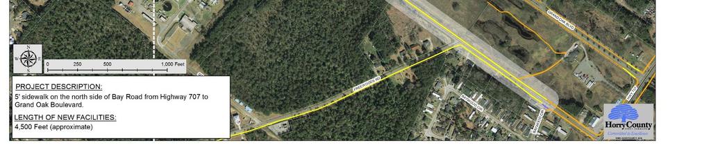
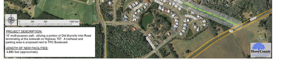
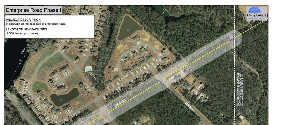
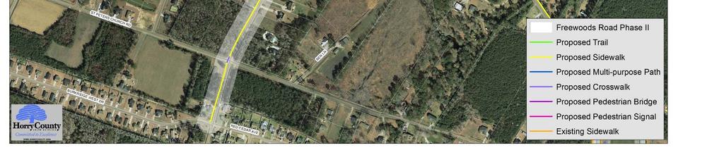
10 Project Bay Road Phase I Bay Road Phase II Big Block Road Blackmoor Trail Burgess Elementary Spur Collins Creek Trail Enterprise Road Phase I Enterprise Road Phase II Freewoods Road Phase I Description 5' sidewalk on the north side of Bay Road from Highway 707 to Grand Oak Boulevard. 5' sidewalk from Grand Oak Boulevard to Enterprise Landing on the north side of Bay Road, transitioning to the south side of Bay Road at the intersection of Henry Middleton Boulevard. 5' sidewalk on the south side of Big Block Road between Highway 707 and Highway ' elevated boardwalk from Prince Creek Trail Phase II to the culde sac terminus of Somersby Drive around the perimeter of Blackmoor Golf Course. 10' multi purpose path on the north side of the school entrance road connecting Scipio Lane to the front entrance of Burgess Elementary. 10' multi purpose path utilizing a portion of Old Murrells Inlet Road, terminating at the sidewalk on Highway 707. A trailhead and parking area is proposed next to TPC Boulevard. Total Project Cost (estimate) Project Length (appx. feet) $/Linear Foot $391,000 4,490 $87 $548,000 7,920 $69 $408,000 4,050 $101 $4,881,000 9,500 $513 $268,000 2,950 $91 $469,000 4,880 $96 5' sidewalk on the east side of Enterprise Road. $261,000 2,500 $104 5' sidewalk from Enterprise Phase I to Socastee Park utilizing Butler Road. The sidewalk terminates at the RC track. 5' sidewalk on the east side of Freewoods Road from Bay Road to Carolina Woods Drive. 5 ' concrete sidewalk on the south side of Bay Road from Baywood Circle to Freewoods Road. $726,000 8,300 $88 $922,000 10,560 $87 Freewoods Road Phase II 5' sidewalk on the west side of Freewoods Road from Carolina Woods Drive to Red Cedar Avenue. $370,000 3,625 $102
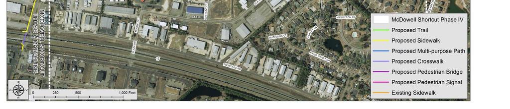
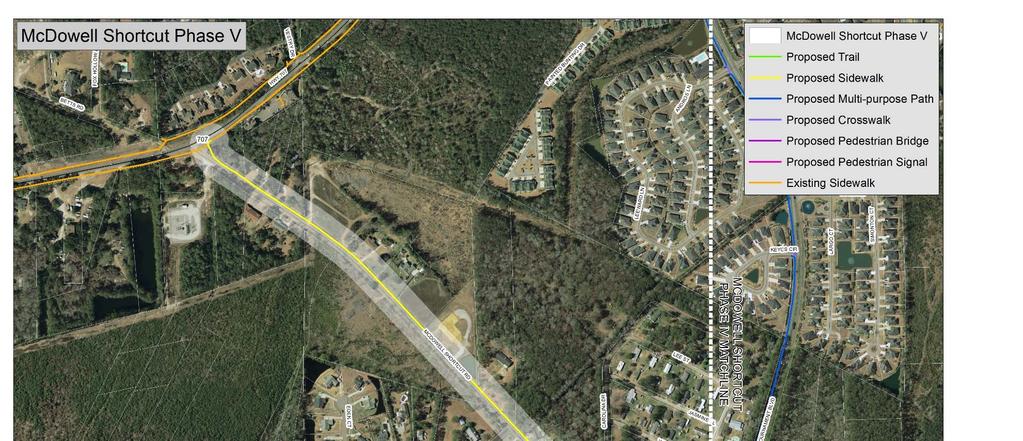
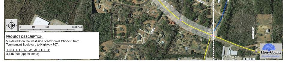
11 Project Holmestown Road Phase I Holmestown Road Phase II Holmestown Road Phase III Holmestown Road Phase IV Longwood Drive McDowell Shortcut Phase I McDowell Shortcut Phase II McDowell Shortcut Phase III Description 8' multi purpose path on the south side of Holmestown Road from Highway 707 to Scipio Lane. The phase includes connecting the existing sidewalks in The Gates subdivision to Holmestown Road. 5' sidewalk on the north side of Holmestown Road from Scipio Lane to Highway 17 Bypass. The phase will connect with the new sidewalk included in the Glenns Bay overpass project. 8' multi purpose path on the south side of Holmestown from Scipio Lane to Highway 17 Bypass. The phase will connect with the new sidewalk included in the Glenns Bay overpass project. 5' sidewalk on the north side of Holmestown Road from Highway 707 to Scipio Lane. 10' multi purpose path on the south side of Longwood Drive from Highway 707 to Waterhall Drive. 5' sidewalk on both sides of McDowell Shortcut from Highway 707 to the intersection of St. James Road. 5' sidewalk on St. James Road in front of both schools (St. James Elementary, St. James Middle). 5' sidewalk on both sides of McDowell Shortcut from St. James Road to Sebastian Drive. 5' sidewalk on the west side of McDowell Shortcut from McDowell Shortcut Phase I signal at St. James Road to Deer Tree Drive. 5' sidewalk on the east side of McDowell Shortcut between Muscari Drive and Stone Throw Drive. Total Project Cost (estimate) Project Length (appx. feet) $/Linear Foot $888,000 7,700 $114 $802,000 3,085 $260 $594,000 2,525 $235 $748,000 6,465 $116 $384,000 4,625 $83 $251,000 2,865 $88 $119,000 1,570 $76 $1,234,000 10,032 $123 McDowell Shortcut Phase IV McDowell Shortcut Phase V 5' sidewalk on the west side of McDowell Shortcut from Stone Throw Drive to Tournament Boulevard. 5' sidewalk on the west side of McDowell Shortcut from Tournament Boulevard to Highway 707. $431,000 3,910 $110 $386,000 3,615 $107
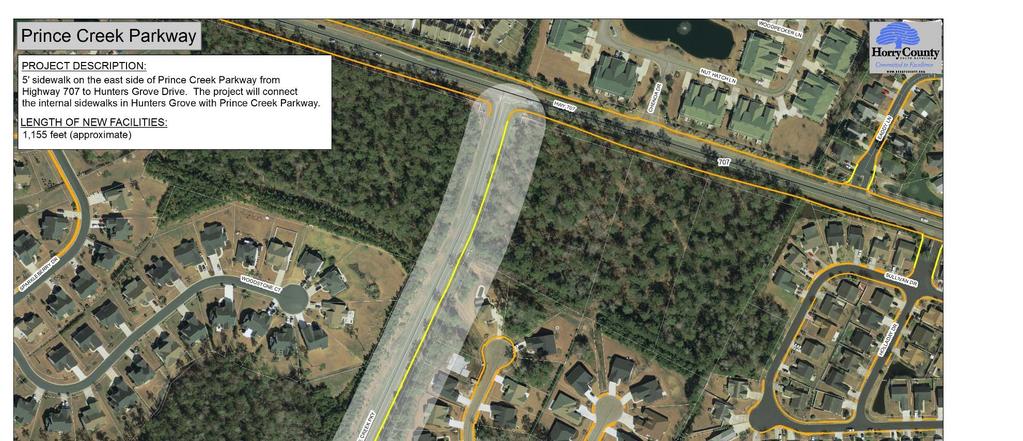
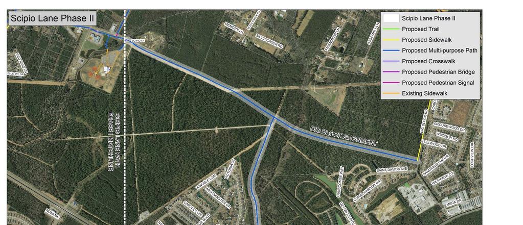
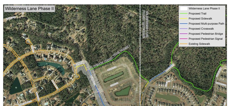
12 Project Prince Creek Parkway Prince Creek Trail Phase I Prince Creek Trail Phase II Salem Road Scipio Lane Phase I Description 5' sidewalk on the east side of Prince Creek Parkway from Highway 707 to Hunters Grove Drive. The project will connect the internal sidewalks in Hunters Grove with Prince Creek Parkway. 8' multi purpose path and elevated boardwalk throughout wooded areas on the western edge of Prince Creek. The project includes a parking area and trailhead at the current terminus of West Creek Drive, and a trailhead at the terminus of Wilderness Lane multi purpose path with a connection to Prince Creek Trail Phase II. Completion of the existing sidewalk on West Creek Drive that converts to a 8' multi purpose path extending to the current terminus of West Creek Drive. 8' multi purpose path and elevated boardwalk throughout wooded areas on the western edge of Prince Creek. Trailheads at Blackmoor Golf Course 10th fairway and the amenity center at Prince Creek Park. Public parking will not be available at either trailhead. 5' sidewalk on the north side of Salem Road from Freewoods Road to Highway 707. The project includes a 5' sidewalk on the south side of Salem Road from the St. James High School entrance to Highway ' multi purpose path on the east side of Scipio Lane from Holmestown Road to the South Strand Recreation Center. The project will connect to the existing trail system at South Strand Recreation Center. Total Project Cost (estimate) Project Length (appx. feet) $/Linear Foot $107,000 1,155 $93 $1,333,000 7,920 $168 $1,779,000 7,026 $253 $597,000 5,280 $113 $188,000 3,380 $56 Scipio Lane Phase II (Big Block) 10' multi purpose path that will coincide with the extension of Scipio Lane, which could potentially connect to Big Block Road or South Strand Commons and Highway 544. $668,000 8,550 $78
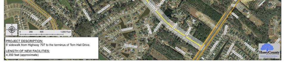
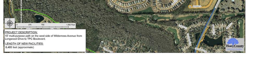
13 Project Scipio Lane Phase II (South Strand) Socastee Park Connector Socastee Park Trail Tern Hall Connector Tournament Boulevard Phase I Tournament Boulevard Phase II Wilderness Avenue Phase I Wilderness Avenue Phase II Description 10' multi purpose path that will coincide with the extension of Scipio Lane, which could potentially connect to Big Block Road or South Strand Commons and Highway ' multi purpose path from Tern Hall Drive to Socastee Park utilizing GSWSA and SCDOT property. Potential expansion of internal trail system TBD based on park expansion utilizing Highway 31 buyout properties. 5' sidewalk from Highway 707 to the terminus of Tern Hall Drive. 10' multi purpose path on the south side of Tournament Boulevard from Highway 707 to McDowell Shortcut. 5' sidewalk on the north side of Tournament Boulevard from Highway 707 to Founders Bay Road. 5' sidewalk from Founders Bay Road to Craven Swamp Drive. 5' sidewalk on the south side of Tournament Boulevard from McDowell Shortcut to Highway 17 Bypass. 10' multi purpose path on the west side of Wilderness Avenue from Longwood Drive to TPC Boulevard. 10' multi purpose path on the west side of Wilderness Avenue from West Creek Drive to the proposed Prince Creek trailhead near Chanted Drive. Total Project Cost (estimate) Project Length (appx. feet) $/Linear Foot $797,000 11,200 $71 $610,000 7,650 $80 TBD TBD TBD $286,000 4,350 $66 $1,442,000 7,400 $195 $97,000 1,160 $84 $548,000 6,500 $84 $176,000 2,000 $88

14


15


16


17


18

19

20


21


22

23
24


25
26


27


28


29


30


31

32
33

34


35


36


37


38

39


40

41


42


43

44

45
Horry County Bicycle and Pedestrian Plan DRAFT. The Burgess Community Bicycle and Pedestrian Plan. Horry County Planning and Zoning Department
 Horry County Bicycle and Pedestrian Plan Bicycle and Pedestrian Plan 1 Horry County Planning and Zoning Department Horry County Bicycle and Pedestrian 2015 Include pedestrian level traffic signaling devices
MAG Town of Cave Creek Bike Study Task 6 Executive Summary and Regional Significance Report
 Page 1 MAG Town of Cave Creek Bike Study Task 6 Executive Summary and Regional Significance Report August 1, 2012 MAG Project #481 Page 2 Task 6 Executive Summary and Regional Significance Report Introduction
WELCOME Public Information Centre
 WELCOME Public Information Centre Fernforest Drive Brampton Soccer Centre Community Room #2 Tuesday January 19, 2016 6:30 p.m.to 9:00 p.m. Please sign in Neighbourhood Traffic Calming Guide Background
Kelowna On the Move. Pedestrian and Bicycle Master Plan
 Kelowna On the Move Pedestrian and Bicycle Master Plan Executive Summary April 2016 Purpose of the Plan The Pedestrian and Bicycle Master Plan identifies infrastructure, planning, and policy requirements
City of Novi Non-Motorized Master Plan 2011 Executive Summary
 City of Novi Non-Motorized Master Plan 2011 Executive Summary Prepared by: February 28, 2011 Why Plan? Encouraging healthy, active lifestyles through pathway and sidewalk connectivity has been a focus
NM-POLICY 1: Improve service levels, participation, and options for non-motorized transportation modes throughout the County.
 Transportation PRINCE WILLIAM COUNTY 2008 COMPREHENSIVE PLAN NON-MOTORIZED PLAN CONTENTS Goals, Policies, and Action Strategies Table 4 (Bike Facility Classifications and Descriptions) Table 5 (Bike Facility
Public Information Centre
 WELCOME Public Information Centre Father Tobin Road Lougheed Middle School - Library Wednesday November 7, 2012 7:00 p.m.to 9:00 p.m. Please sign in Neighbourhood Traffic Calming Guide Background The City
STREET AND HIGHWAY PLAN
 STREET AND HIGHWAY PLAN Introduction The street and highway system in the Winston-Salem Urban Area consists of thousands of miles of traffic carrying facilities, ranging from short local residential streets
Executive Summary Route 30 Corridor Master Plan
 Route Corridor Master Plan Project Overview The Route Corridor Master Plan is a coordinated multimodal transportation and land use plan for the entire stretch of Route through East Whiteland Township,
Goodlettsville Bicycle and Pedestrian Plan Executive Summary
 Goodlettsville Bicycle and Pedestrian Plan July 2010 In Cooperation with the Nashville Area Metropolitan Planning Executive Organization Summary Introduction Progressive and forward thinking communities
Living Streets Policy
 Living Streets Policy Introduction Living streets balance the needs of motorists, bicyclists, pedestrians and transit riders in ways that promote safety and convenience, enhance community identity, create
o n - m o t o r i z e d transportation is an overlooked element that can greatly enhance the overall quality of life for the community s residents.
 N o n - m o t o r i z e d transportation is an overlooked element that can greatly enhance the overall quality of life for the community s residents. 84 Transportation CHAPTER 11 INTRODUCTION Transportation
Chapter 5 Future Transportation
 Chapter 5 Future Transportation The Future Land Use Plan identifies the desired land use designations. The land uses desired for Crozet depend, in large part, on the success of the transportation system,
Tonight is for you. Learn everything you can. Share all your ideas.
 Strathcona Neighbourhood Renewal Draft Concept Design Tonight is for you. Learn everything you can. Share all your ideas. What is Neighbourhood Renewal? Creating a design with you for your neighbourhood.
CONNECTING PEOPLE TO PLACES
 CONNECTING PEOPLE TO PLACES 82 EAST BENCH MASTER PLAN 07 Introduction The East Bench transportation system is a collection of slow moving, treelined residential streets and major arteries that are the
City of Charlottesville Bicycle and Pedestrian Master Plan Update
 City of Charlottesville Bicycle and Pedestrian Master Plan Update September 17, 2014 I. Welcome and meeting overview II. Project status update III. Network overview IV. Break-out groups Pedestrian Network
CITY OF COCOA BEACH 2025 COMPREHENSIVE PLAN. Section VIII Mobility Element Goals, Objectives, and Policies
 CITY OF COCOA BEACH 2025 COMPREHENSIVE PLAN Section VIII Mobility Element Goals, Objectives, and Policies Adopted August 6, 2015 by Ordinance No. 1591 VIII MOBILITY ELEMENT Table of Contents Page Number
Safe Streets. City of Lake Forest Park. March 21, 2017
 Safe Streets City of Lake Forest Park March 21, 2017 1 01 WELCOME 2 Agenda WELCOME WHAT IS THIS PROJECT? CONTEXT DRAFT CITYWIDE PROJECTS EXERCISE INTRODUCTION 3 02 WHAT IS THIS PROJECT? 4 WHAT IS THIS
Exhibit 1 PLANNING COMMISSION AGENDA ITEM
 Exhibit 1 PLANNING COMMISSION AGENDA ITEM Project Name: Grand Junction Circulation Plan Grand Junction Complete Streets Policy Applicant: City of Grand Junction Representative: David Thornton Address:
EXECUTIVE SUMMARY. Vision
 Vision Walking and bicycling in Salt Lake City will be safe, convenient, comfortable, and viable transportation options that connect people to places, foster recreational and economic development opportunities,
Transportation Master Plan Advisory Task Force
 Transportation Master Plan Advisory Task Force Network Alternatives & Phasing Strategy February 2016 BACKGROUND Table of Contents BACKGROUND Purpose & Introduction 2 Linking the TMP to Key Council Approved
5 Transit & Traffic. Overview
 5 Transit & Traffic Overview Montgomery Place s roadways and overall traffic circulation are unique in the city due to the narrow streets and avenues with boulevards; however, no sidewalks or curbs in
Solana Beach Comprehensive Active Transportation Strategy (CATS)
") Solana Beach Comprehensive Active Transportation Strategy (CATS) 3.0 Goals & Policies The Solana Beach CATS goals and objectives outlined below were largely drawn from the Solana Beach Circulation Element
Solana Beach Comprehensive Active Transportation Strategy (CATS) 3.0 Goals & Policies The Solana Beach CATS goals and objectives outlined below were largely drawn from the Solana Beach Circulation Element
Overview. Illinois Bike Summit IDOT Complete Streets Policy Presentation. What is a Complete Street? And why build them? And why build them?
 Overview Illinois Bike Summit IDOT Complete Streets Policy Presentation Aren Kriks, P.E. District One Bicycle Coordinator and Bureau of Programming Project Engineer History of Complete Streets IDOT Policy
Proposed Amendment to the City-Wide Trails Plan
 Proposed Amendment to the City-Wide Trails Plan Planning and Zoning Commission June 23, 2015 Comprehensive Plan 2010 Sustainable Community Recommendations 2 Goal: Walking and Cycling are Encouraged throughout
Broad Street Bicycle Boulevard Design Guidelines
 Broad Street Bicycle Boulevard Design Guidelines Building from the strategies introduced in the 2013 Bicycle Transportation Plan and community input received thus far, City Transportation Staff have identified
TRANSPORTATION & MOBILITY
 TRANSPORTATION & MOBILITY ROADWAY SYSTEM There are approximately 40 miles of roadways in Manitou Springs. For planning purposes, roadways are typically assigned a functional classification which defines
Lee s Summit Road Improvement Study Public Open House June 7, 2007 Summary of Comment Card Responses
 Lee s Summit Road Improvement Study Public Open House June 7, 2007 Summary of Comment Card Responses Introduction At the Lee s Summit Road Improvement Study Public Open House held Thursday, June 7, 2007
Bikeway action plan. Bicycle Friendly Community Workshop March 5, 2007 Rochester, MN
 Bikeway action plan Summary The was held on March 5, 2007 at the Rochester Mayo Civic Center. The workshop was hosted by Rochester-Olmsted County Planning Department in collaboration with the League of
Edenbrook Hill Drive Traffic Calming Study
 WELCOME Public Information Centre Edenbrook Hill Drive Traffic Calming Study Fletchers Meadow Secondary School Wednesday January 20, 2016 6:30 p.m.to 9:00 p.m. Please sign in Neighbourhood Traffic Calming
Terwillegar Drive Expressway Draft Concept Plan
 Terwillegar Drive Expressway Draft Concept Plan Anthony Henday Drive to Whitemud Drive November 28 5:00-8:00 p.m. December 1 10:00 a.m. - 3:00 p.m. Let s Talk Today you can: Learn about the new direction
TOWN OF WILLIAMSTON, SC BICYCLE AND PEDESTRIAN MASTER PLAN TOWN OF WILLIAMSTON, SC BICYCLE AND PEDESTRIAN MASTER PLAN
 TOWN OF WILLIAMSTON, SC BICYCLE AND PEDESTRIAN MASTER PLAN Americans Want Choices 55% of Americans would rather drive less & walk more. Transit use is growing faster than population or highway travel.
Bicycle Facilities Planning
 Bicycle Facilities Planning Overview Types of Cyclists Purpose for Riding Types of Facilities Bike Lanes Bicycle Boulevards Cycle Tracks Intersections Signals Signing and Marking Discussion Types of Bicyclists
Basalt Creek Transportation Refinement Plan Recommendations
 Basalt Creek Transportation Refinement Plan Recommendations Introduction The Basalt Creek transportation planning effort analyzed future transportation conditions and evaluated alternative strategies for
10A. DATE: October 5, Pedestrian and Bicycle Advisory Committee. Kevin Colin, Deputy Planning Manager Curt Bates, City Engineer
 10A DATE: October 5, 2016 TO: PREPARED BY: SUBJECT: Pedestrian and Bicycle Advisory Committee Kevin Colin, Deputy Planning Manager Curt Bates, City Engineer Discussion and Provide Comments, Associated
University of Victoria Campus Cycling Plan Terms of Reference. 1.0 Project Description
 University of Victoria Campus Cycling Plan Terms of Reference 1.0 Project Description The Campus Cycling Plan, a first for the University, will provide a comprehensive and coordinated approach to support
2.0 Existing Conditions
 20 2.0 Existing Conditions 2.1 Land Use, Future Growth Patterns, Physical Barriers Geographic Overview Sutter County s land use pattern is characterized by extensive agricultural areas, significant natural
CITY OF BLOOMINGTON COMPLETE STREETS POLICY
 CITY OF BLOOMINGTON COMPLETE STREETS POLICY POLICY OBJECTIVE: The City of Bloomington will enhance safety, mobility, accessibility and convenience for transportation network users of all ages and abilities,
DRAFT. System Components. Greenway Trails. Introduction. Trail Types. Zebulon Greenway Master Plan
 5 System Components Wakefield Street Photo Simulation showing Sharrows Introduction The Master Plan identifies various system components that, together, create a comprehensive greenway system. These components
2014/2015 BIKE ROUTE PLAN 83 AVENUE PROTECTED BIKE LANE
 About the Project 2014/2015 BIKE ROUTE PLAN The City of Edmonton is planning a major bike route on the south side of Edmonton. This bike route is one part of a plan to provide citizens with transportation
APPENDIX A: Complete Streets Checklist DRAFT NOVEMBER 2016
 APPENDIX A: Complete Streets Checklist DRAFT NOVEMBER 2016 Complete Streets Checklist MetroPlan Orlando s Complete Streets Checklist is an internal planning tool for staff to further implementation of
Corpus Christi Metropolitan Transportation Plan Fiscal Year Introduction:
 Introduction: The Safe, Accountable, Flexible, Efficient Transportation Equity Act: A Legacy for Users (SAFETEA-LU) has continued the efforts started through the Intermodal Surface Transportation Efficiency
Perryville TOD and Greenway Plan
 Perryville TOD and Greenway Plan Greenway Glossary Pathway: A bicycle and pedestrian path separated from motorized vehicular traffic by an open space, barrier or curb. Multi-use paths may be within the
Physical Implications of Complete Streets Policies
 Presentation Overview Physical Implications of Complete Norm Cox, ASLA, LLA Landscape Architect Ann Arbor, Michigan, 10:45 to Noon What Are Complete Streets? What Matters to Bicyclists and Pedestrians
CONNECTIVITY PLAN. Adopted December 5, 2017 City of Virginia Beach
 CONNECTIVITY PLAN Adopted December 5, 2017 City of Virginia Beach CONTENTS 1.0 Background & Purpose... 2 2.0 Existing Inventory & Analysis... 3 ViBe District Existing Walking Conditions... 4 3.0 ViBe District
West Dimond Blvd Upgrade Jodhpur Street to Sand Lake Road
 West Dimond Blvd Jodhpur St to Sand Lake CSS Transportation Project Summary Municipality of Anchorage Project # 05 005 Project Manager: John Smith, P.E. (MOA PM&E) Project Administrator: Julie Makela,
Make Lincoln Highway an economically vibrant corridor that is safe, efficient, and beautiful for local residents and visitors.
 Lincoln Highway Streetscape Plan Stakeholder Workshop #2 Handout Contents Introduction and Project Vision Planning Principles Specific Recommendations including a Proposed Typical Roadway Section Renderings
Bicycle-Pedestrian Master Plan: Chapters 3 and 4 Distribution
 Bicycle-Pedestrian Master Plan: Chapters 3 and 4 Distribution Finksburg Planning and Citizens Council March 22, 2018 Overview Progress Citizen Outreach Vision Chapter 3 - Existing Conditions Chapter 4
WHEREAS delivery trucks also pass through the Narrows, into the northern parking lot, to loading docks in the back of the building.
 CEDAR-ISLES-DEAN NEIGHBORHOOD ASSOCIATION ( CIDNA ) RESOLUTION OPPOSING A DRUG STORE DRIVE THRU, AND COMMENDING DORAN COMPANIES FOR PROPOSING MITIGATING AMENITIES INCLUDING NEW LANDSCAPING AND A DEDICATED
12 RECOMMENDATIONS Road Improvements. Short Term (generally the next five years)
") 12 RECOMMENDATIONS Recommendations are based on the technical analysis of existing and future road and active transportation conditions, the results of the review of existing City policies and public feedback.
12 RECOMMENDATIONS Recommendations are based on the technical analysis of existing and future road and active transportation conditions, the results of the review of existing City policies and public feedback.
4 Goals, Objectives & Actions
 Chapter4 4 This chapter presents goals, objectives, and recommended actions to support the vision of making Overland Park a safer and easier place to ride a bicycle. 35 4.1 Recommendations Structure The
PROJECT BACKGROUND/DESCRIPTION
 SCOPE OF SERVICES St. Charles Parish Comprehensive Pedestrian and Bicycle Master Plan (CPBP) St. Charles Parish, Louisiana State Project No. H. 012462 RPC Project No. SCPBMP1 PROJECT BACKGROUND/DESCRIPTION
15 April CAMPUS MASTER PLAN UPATE F o c us G r o up M o b ility
 15 April 2016 CAMPUS MASTER PLAN UPATE F o c us G r o up M o b ility AGENDA What We Heard Campus Framework & Open Space Network Mobility Approach Supporting the Pedestrian Environment Mobility & Sustainability
3.9 Recreational Trails and Natural Areas
 3.9 Recreational Trails and Natural Areas 3.9.1 Introduction Parks and other recreational facilities such as trails, bicycle routes, and open space are important community resources. This section discusses
Pattullo Bridge Replacement Project Community Connections Phase 2 Consultation. Appendix 3: Open House Display Boards
 Replacement Project Community Connections Phase 2 Consultation Appendix 3: Open House Display Boards November 2016 Welcome! Welcome to the Replacement Project Public Open House We Want to Hear from You
ACTIVE TRANSPORTATION
 ACTIVE TRANSPORTATION Mobility 2040 Supported Goals Improve the availability of transportation options for people and goods. Support travel efficiency measures and system enhancements targeted at congestion
TRANSPORTATION NEEDS ASSESSMENT
 TRANSPORTATION NEEDS ASSESSMENT A travel demand analysis was carried out to determine the operational issues and the potential benefit that adding traffic capacity would have on the road network. All the
Moving Cambridge. City of Cambridge Transportation Master Plan Public Consultation Centre. March 7, :00 8:00 PM.
 City of Cambridge Transportation Master Plan Public Consultation Centre March 7, 2018 5:00 8:00 PM Region of Waterloo City of Cambridge Transportation Master Plan Public Consultation Centre March 7, 2018
RZC Appendix 8A Marymoor Subarea Street Requirements
 RZC Appendix 8A Marymoor Subarea Street Requirements For additional design details for Marymoor Subarea infrastructure, refer to the 2017 Marymoor Subarea Infrastructure Planning Report. STREET REQUIREMENTS
PRINCE GEORGE S PLAZA METRO AREA PEDESTRIAN PLAN
 PRINCE GEORGE S PLAZA METRO AREA PEDESTRIAN PLAN May 28, 2008 Agenda Welcome and introductions Project overview and issue identification Planning context and strengths Design challenges and initial recommendations
See Figure 38, Existing Nonmotorized Connections.
 Nonmotorized Connections Existing Nonmotorized Connections Pedestrian, vehicle and bike traffic access and movements are confined primarily to Penny Drive on campus. Due to the steep slope along the length
CITY OF SAINT JOHN TRAFFIC CALMING POLICY
 CITY OF SAINT JOHN TRAFFIC CALMING POLICY VERSION: 1.0 April 10, 2012 Pedestrians, Cyclists and Motorists Sharing Street Spaces CONTENTS INTRODUCTION... 3 POLICY GOAL... 3 POLICY OBJECTIVES... 3 GUIDING
Watertown Complete Streets Prioritization Plan. Public Meeting #1 December 14, 2017
 Watertown Complete Streets Prioritization Plan Public Meeting #1 December 14, 2017 Goals for Public Meeting Overview of MassDOT Complete Streets Funding Program Educate the community on Complete Streets
Non-Motorized Transportation 7-1
 Non-Motorized Transportation 7-1 Transportation facilities no longer mean just accommodating a vehicle powered by a combustion engine. Pedestrian and non-motorized facilities are important modes of travel
Transportation Assessment
 Transportation Assessment Midtown Open House February 10, 2018 Overview Midtown in Focus Overview & Purpose of Today Transportation Assessment overview Summary of Transportation work to date Review & Analysis
El Camino Real Specific Plan. TAC/CAC Meeting #2 Aug 1, 2018
 El Camino Real Specific Plan TAC/CAC Meeting #2 Aug 1, 2018 Land Use Alternatives Goals and Tradeoffs Parks & open space Housing Retail & services Civic spaces Parking Community gathering spaces 3 Alternatives
City of Wilsonville 5 th Street to Kinsman Road Extension Project
 City of Wilsonville 5 th Street to Kinsman Road Walking Tour & Neighborhood Workshop Summary Report Public Outreach Overview On July 18 th, 2017, the City of Wilsonville hosted a neighborhood walking tour
MASTER BICYCLE AND PEDESTRIAN PLAN
 VILLAGE OF NORTHBROOK MASTER BICYCLE AND PEDESTRIAN PLAN DRAFT PLAN OPEN HOUSE May 2, 2018 AGENDA 1. Community Engagement 2. Vision and Goals 3. General Structure of Plan 4. Recommendations Overview 5.
5 CIRCULATION AND STREET DESIGN
 5 CIRCULATION AND STREET DESIGN This chapter describes circulation and streetscape improvements proposed for the Northwest Chico Specific Plan Area. It includes detailed design specifications for existing
Castro Valley Municipal Advisory Council March 19, 2018
 Castro Valley Municipal Advisory Council March 19, 2018 1 Background 2 Draft Bicycle Vision and Pedestrian Networks 3 Next Steps 4 Updates Agenda 2 PROJECT AREA: Unincorporated Areas of Alameda County
Plant City Walk-Bike Plan
 Plant City Walk-Bike Plan Plant City Commute Mode Share 2.2% 1.4% 2.9% Drove alone 10.2% Carpooled Public transportation (0.1%) Walked Used a Bike (0.4%) 82.9% Taxicab, motorcycle, or other means Worked
Developing a Bike/Pedestrian Plan Using ArcInfo and Public Participation Rob Shumowsky, Madison County Council of Governments
 Developing a Bike/Pedestrian Plan Using ArcInfo and Public Participation Rob Shumowsky, Madison County Council of Governments Abstract: The Madison County Council of Governments is creating a bike/pedestrian
Clackamas County Comprehensive Plan
 ROADWAYS The County s road system permits the movement of goods and people between communities and regions, using any of a variety of modes of travel. Roads provide access to virtually all property. They
Bicycle and Pedestrian Plans and Improvements
 Bicycle and Pedestrian Plans and Improvements Presented to the City Council By Randle Harwood, Planning and Development, and Richard Zavala, Parks and Community Services September 24, 2013 Purpose Review
Hennepin County Bicycle and Pedestrian Planning
 Hennepin County Bicycle and Pedestrian Planning 1 Value of bicycle and sidewalk systems Safety Livability Mobility Health Personal Finances Economic Sustainability Clean Air Recreation Parking and congestion
City of Sammamish. Welcome. Issaquah-Fall City Road Improvements Project Phase I Design: 242nd Avenue SE to Klahanie Drive SE
 Welcome Welcome to the third community meeting for the Issaquah-Fall City Road Improvements Project. AGENDA 6:00 p.m. Welcome and sign-in 6:10 p.m. Presentation 6:50 p.m. Open house Learn about the roadway
PRESS RELEASE San Joaquin Council of Governments
 PRESS RELEASE San Joaquin Council of Governments For Immediate Release February 23, 2018 Contact: Nicole Gorham, 235-0582 gorham@sjcog.org SJCOG Board Awards $19.63 Million in Measure K Bicycle, Pedestrian,
Duwamish Way-finding and CTR Report
 V. North Tukwila When the North Tukwila Manufacturing and Industrial Center was designated in 1992 as part of the region s land use and transportation plan, the plan called for the area to set a light-rail
Prince George s County plans, policies, and projects
 Prince George s County plans, policies, and projects Over 250 projects for trails, bikeways, designated bike lanes and sidewalk construction Trail projects that improve access to Metro Sidewalk and trail
Pennsylvania Avenue (CR 484) Design Alternatives Study
 Design Alternatives Study") MEMORANDUM Pennsylvania Avenue (CR 484) Design Alternatives Study Prepared for: APRIL 2016 Prepared By TABLE OF CONTENTS Project Background... 2 Previous Concept... 2 Existing Conditions... 4 New Alternatives...
MEMORANDUM Pennsylvania Avenue (CR 484) Design Alternatives Study Prepared for: APRIL 2016 Prepared By TABLE OF CONTENTS Project Background... 2 Previous Concept... 2 Existing Conditions... 4 New Alternatives...
CLOSED. The draft concept design has been broken down into 5 categories for the purpose of this survey:
 Old Strathcona s neighbourhood renewal process is now at the draft concept design phase. Over the last several months, the city has been gathering local knowledge and resident input that has been used
Chapter 9: Pedestrians and Bicyclists
 Chapter 9: Pedestrians and Bicyclists Walking and bicycling are essential modes of transportation. These modes allow people to travel without contributing to congestion and air pollution, to access other
12/4/2016 VIA . RE: Grocery Outlet Del Paso (DR16-328)
") 12/4/2016 VIA EMAIL Ethan Meltzer, Assistant Planner City of Sacramento Community Development Department 300 Richards Blvd, 3 rd Floor Sacramento, CA 95811 RE: Grocery Outlet Del Paso (DR16-328) Dear Mr.
12/4/2016 VIA EMAIL Ethan Meltzer, Assistant Planner City of Sacramento Community Development Department 300 Richards Blvd, 3 rd Floor Sacramento, CA 95811 RE: Grocery Outlet Del Paso (DR16-328) Dear Mr.
Final Sidewalk Feasibility Study
 Garfield Drive From Anastasia Drive to Elizabeth Place City of South Daytona July 23, 2009 Final Sidewalk Feasibility Study Prepared for: Prepared by: Final Sidewalk Feasibility Study Garfield Drive 2
Durham Region Long Term Transit Strategy
 Durham Region Long Term Transit Strategy An adaptive, safe, reliable, frequent, accessible and desirable transit system that shapes and connects Durham Region and beyond in an economically and environmentally
City of Birmingham Draft Multi-modal Transportation Plan
 City of Birmingham Draft Multi-modal Transportation Plan City Commission Public Hearing Monday, November 25, 2013 7:30 pm Norman Cox, PLA, ASLA The Greenway Collaborative, Inc. Ann Arbor, Michigan The
CITY OF PORTSMOUTH PLANNING DEPARTMENT
 CITY OF PORTSMOUTH PLANNING DEPARTMENT MEMORANDUM TO: JOHN P. BOHENKO, CITY MANAGER FROM: JULIET T.H. WALKER, PLANNING DIRECTOR SUBJECT: BICYCLE / PEDESTRIAN PLAN PROGRESS UPDATE DATE: 3/13/2018 Background
Public Feedback Comments Appendix G. Appendix G. Public Feedback Comments. Virginia Beach Bikeways and Trails Plan 2011 Page G-1
 Public Feedback Comments Virginia Beach Bikeways and Trails Plan 2011 Page G-1 This is a complete collection to date of responses to the feedback survey which was used at public open houses in December
TRANSPORTATION TRAINING TOPICS. April 6, 2010
 TRANSPORTATION TRAINING TOPICS April 6, 2010 Roles of Transportation Providers Context and Policy Makers Division of Transportation and Traffic Other City Operations Other Transportation Operators CMA
Agenda. Overview PRINCE GEORGE S PLAZA METRO AREA PEDESTRIAN PLAN
 PRINCE GEORGE S PLAZA METRO AREA PEDESTRIAN PLAN May 28, 2008 Agenda Welcome and introductions Project overview and issue identification Planning context and strengths Design challenges and initial recommendations
Department of Transportation
 Department of Transportation I. Internal Scan The number of older drivers in the United States will double over the next 30 years. By 2030 one in five Americans will be age 65 or older. On a licensed-driver
8 Bicycle and Pedestrian Facilities
 8 Bicycle and Pedestrian Facilities 8.1 Existing Facilities The facilities available to walkers and bikers are diverse in the rural ACOG area. Walking and biking are, by their nature, localized modes of
Thank you for this opportunity to discuss with you how we can work together to make our streets more complete.
 Thank you for this opportunity to discuss with you how we can work together to make our streets more complete. 1 2 3 Thank you for this opportunity to discuss with you how we can work together to make
Hennepin County Transportation Department
 Hennepin County Transportation Department Complete Streets Design and Implementation Prepared for the Complete Streets Task Force Craig Twinem, P.E. Design Division Manager Tom Johnson, P.E. Transportation
PROPOSED BICYCLE AND PEDESTRIAN FACILITY Vicinity of Route 123/I-495 Interchange Tysons, Fairfax County, Virginia
 PROPOSED BICYCLE AND PEDESTRIAN FACILITY Vicinity of Route 123/I-495 Interchange Tysons, Fairfax County, Virginia PRELIMINARY ENGINEERING REPORT Prepared for: Prepared by: July 2017 Table of Contents 1
Sustainable Mobility in Greater Sudbury NeORA Conference September 25, 2012
 Sustainable Mobility in Greater Sudbury NeORA Conference September 25, 2012 Presented by: David Shelsted, MBA, P.Eng., Director of Roads & Transportation Services The City s Transportation Network Approximately
Appendix 3 Roadway and Bike/Ped Design Standards
 Appendix 3 Roadway and Bike/Ped Design Standards OTO Transportation Plan 2040 4/20/2017 Page A3-1 Adopted Standards The adopted OTO Design Standards and Major Thoroughfare Plan are contained herein.
ENFIELD TOWN THE REVISED DESIGN
 TOWN THE REVISED DESIGN We re turning Enfield into a borough that encourages walking and cycling, a place that s easy for all of us to get around however we choose to travel. A greener place, with safer
WALKNBIKE DRAFT PLAN NASHVILLE, TENNESSEE EXECUTIVE SUMMARY NASHVILLE, TENNESSEE
 NASHVILLE, TENNESSEE EXECUTIVE SUMMARY Executive Summary A world-class multi-modal transportation system is essential to a vibrant city and better quality of life. -Mayor Barry The WalknBike plan aims
East Burke Transportation, Safety and Capacity Improvements
 East Burke Transportation, Safety and Capacity Improvements The purpose of this project is to increase mobility and improve safety for pedestrians, cyclists, and motor vehicles along VT Route 114 in the