Borderline- Part 3 SURFACE. Syracuse University. Francis McKloskey. Spring 2013
|
|
|
- Silvester Snow
- 6 years ago
- Views:
Transcription
. Architecture Senior Theses. Paper 204. http://surface.")
1 Syracuse University SURFACE Architecture Senior Theses School of Architecture Dissertations and Theses Spring 2013 Borderline- Part 3 Francis McKloskey Follow this and additional works at: Part of the Architecture Commons Recommended Citation McKloskey, Francis, "Borderline- Part 3" (2013). Architecture Senior Theses. Paper This Article is brought to you for free and open access by the School of Architecture Dissertations and Theses at SURFACE. It has been accepted for inclusion in Architecture Senior Theses by an authorized administrator of SURFACE. For more information, please contact surface@syr.edu.

2 Aralsk Muynak
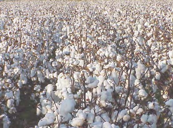
3 Aralsk 47 North Aral Maloye Morye (Little Sea) Kokaral Peninsula Kokaral Island Kokaral Dam 46 Syr River Vozrozhdeniya South Aral Bolshoye Morye (Big Sea) 45 Syr River Ba The Amu Darya originally had a series of tributaries that flowed into the Aral Sea up until the 1970 s. Hydrological works began in the 1950 s, where much of its waters were being taken to irrigate cotton and wheat in the lower basin of the river. In the 1960 s, the Soviet Government completed the Karakum Canal to divert large amounts of water westward. Due to the decreased input of water, the Aral Sea started shrinking. To make matters worse, the hot, dry plains of the Amu Darya accelerated evaporation, not only decreasing the quantity of water, but depleting the nutrient quality of the soils due to the salt deposits being left. By the 1990 s the Amu Darya s discharge onto the Aral would stop periodically until its present point: 120 km ahead, due to a dam for irrigation Muynak Amu River Amu River Basin Amu River Basin TURKMENISTAN UZBEKIS
4 Syr River Basin KAZAKHSTAN sin The Syr Darya and its tributaries, similar to the Amu Darya, irrigates massive exents of land for the purposes of cotton and wheat agriculture. It is estimated that the Syr Darya alone is responsible for 5,000,000 acres of cotton growth. Its water diversion also contributed to the shrinkage of the Aral Sea, with a much smaller flow of water than it did in the first half of the 20th century. Due to increased salinification of soils, there is an added need for farmers to incorporate fertilizer into their processes, which makes it downstream into the sea. These chemicals are left as residue on the dried seabed, which then get airborne, to further challenge plant and animal life. Particularly, the local populations have had an exponential increase in respiratory illnesses. 1 TAN KYRGYZSTAN TAJIKISTAN


5


6

7

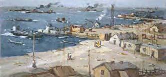
8 Before then, the Aral exported roughly 40,000 tons of fish annually, and was a sea with many large (100 ) industrial ships. There were thousands of fishermen, while another portion of the populaion was employed in the processing plans, canneries, and railroad yards. Trains left daily for Moscow with their cars full of fish. The population was rather large, including 19 villages around the sea with two large cities. 40,000 people lived in Moynaq, Uzbekistan at the southern tip, and 80,000 people lived in Aralsk, Kazakhstan in the norhern tip. Nowadays Kazakhstan and Uzbekistan face an influx of disaster tourism, or tourism geared towards observing the visible disaster of the Aral Sea. Especially famous are the iconic rusting ships scattered all over the landscape.


9 Soviet engineers designed a massive irrigation network with 45 dams, 80 reservoirs, and more than 20,000 miles of canals, that are leaky and inefficient. The Amu Darya s flow is so reduced that it no longer reaches the Aral Sea, now ending 70 miles away. Cotton naturally grows in the tropics, due to the humidity. Rain, however, is problematic because the plants absorbs water and rot. These plants need sunlight and plenty of water, and therefore are best cultivated in dry areas and irrigated artificially. The lake s salinization has accelerated the lake s evaporation. With rapid changes in temperature, the surface water has a lower salinity than the bottom water. Surface water thus heats up faster than if the salinity was equaly at all depths.


10 An estimated 43 million metric tons of sand, salt and dust of the former seabed have been picked up by strong winds that now make km wide dust storms. The dust is often carried great distances, up to 500 km away, and depleting the nutrient quality of surrounding soils. With a lowering of the water table, and increased deposits of salt, local agricultural industry must use more additives in their production, which in turn makes its way down the watershed, contributing to the contamination of soils and the quality of the air. The former island of Vozrozhdeniya was the USSR s testing site for bioweapons such as anthrax, smallpox, plague, brucellosis, and tuleramia. The town of Kantubek once had 1,500 inhabitants, who left in Many containers holding spores have developed leaks since.


11


12 moving borders As the Aral sea shrank in size, up to 10% of its original size by 2007, it receded from the harbors of Aralsk and Moynaq. Fishermen started by extending their ports by deepening canals. They ultimately relied on helicopters to get their catch to the Aralsk and Moynaq processing plants when needed. 1
13 Aralsk 47 Aralsk Syr River 46 Syr River Muynak Muynak Amu River
![site opportunities Kazakhstan preserving what was left in the Little Aral from spilling into the evaporating desert flow toward Uzbekistan The [North] Aral ecosystem has since then started to recover](/docs-images/72/66256105/images/14-0.jpg "slowly with the help of the $85 million 8-mile long Kokoral Dam, mostly funded by the World Bank.")
14 site opportunities Kazakhstan preserving what was left in the Little Aral from spilling into the evaporating desert flow toward Uzbekistan The [North] Aral ecosystem has since then started to recover slowly with the help of the $85 million 8-mile long Kokoral Dam, mostly funded by the World Bank. This Dam was expected to raise the water level in the North Aral Sea by about 13 feet in five years, but surprisingly did so in 8 months. Salinity lowered to levels much closer to those of the 1960s, and native plants and migrating birds have again started to emerge. Freshwater fish (pike, perch and carp) are finally returning to the Aral. In 2008 fishermen caught 1,500 tons of fish, close to 3,000 in 2011, and 10,000 in 2012*. They began selling locally, but have already started exporting to Russia and Georgia. Two fish processing plants are operating in the [farfrom-coast] former fishing town of Aralsk, while a third is under construction. People who left the region when they were young are starting to return to the Aral for fishing. Additionally, the government is attempting to promote tourism to the returning the Aral Sea, as disaster tourism is currently creating one of the largest influxes of tourists to Kazakhstan.


15

16 point of exchange By taking advantage of the 100m stretch of Kokaral dam that flows outward to the Large Aral, one can exploit the brief point of contact between the contained ecosystem of the north and the disappearing landscape of the south. The natural space for this transformation is the borderline, where systems of all kinds collide and abrade, as the world breaks up, not into chaos, but rather into new patterns of order. 1 Lebbeus Woods describes borderlines as collisions between landscapes and the overlay between systems.

17

18 In 2010, British photographer Chloe Dewe Mathews hitchhiked from China to Britain. Part of her work, as seen in Aral: A Dammed Sea," was documenting the miracle of the return of the North Aral. She witnessed and documented how the youth of the surrounding villages, are once again taking up fishing as an economic activity, after a major generational gap. Dewe Mathews describes the Kok-Aral during the three month fishing period, when a group of young fishermen have taken to camping (right image) for fishing day and night near the spillway, despite the remote location. Because the dam works like a funnel, it concentrates the flux of fish, providing for a vantage point from which to gather the catch (left image). After the season is finished, the young men return to their respective villages.
19 The construction of the dam, which cost approximately $81,000,000 USD, is the third of its kind at the Kokaral site. An earlier example was built in 1992 with rather loose construction, and was destroyed within 9 months in spring 1993 due to a sharp Sea level rise. Its construction was a matter of budget due to the fact that it was built directly from funds by the locals. In 1996, a second attempt to preserve the North Aral was started, with construction finishing in spring This was the first iteration of the current 14km by 30m layout.
20 Environmental and biological benefits started to emerge, with increased rainfall, and decreased salinity which boosted flora and fauna in the North Aral. In 1999, the increased water flow of the Syr Darya again washed the dam, in a 4 km segment. Work on the current dam was completed in It incorporated the compacted sand of the 1999 dam, with concrete covers and a roadway on top.
Research report. Environmental Commission: Sub-commission 1 The question of the Aral Sea By: Aaron Gilchrist
 Research report Environmental Commission: Sub-commission 1 The question of the Aral Sea By: Aaron Gilchrist Introduction The Aral Sea forms part of southern Kazakhstan and part of the autonomous Republic
Chapter 4: Google Earth Exercise
 Chapter 4: Google Earth Exercise Exercise 1 Visualizing the Three Gorges Dam Hydroelectric Project The Three Gorges Dam was the largest infrastructure project in China since the Great Wall. Completed in
1. LARGE-SCALE DEVELOPMENT OF NEW LANDS 2. CONFLICT OF HUMAN AND NATURE 3. ECOLOGICAL PROBLEMS
 Aral Sea Basin 1. LARGE-SCALE DEVELOPMENT OF NEW LANDS 2. CONFLICT OF HUMAN AND NATURE 3. ECOLOGICAL PROBLEMS INCREASED LEVEL OF WATER MINERALIZATION SOIL SALINITY DECREASED PRODUCTIVITY OF LANDS DESERTIFICATION
Module 1 Educator s Guide Investigation 2
 Module 1 Educator s Guide Investigation 2 What is happening to the Aral Sea? Investigation Overview In Investigation 2, students work as teams of NASA geographers using satellite images to measure the
CURRENT STATUS OF LAKE ARAL CHALLENGES AND FUTURE OPPORTUNITIES
 16 th World Lake Conference Bali, Indonesia November 8, 2016 CURRENT STATUS OF LAKE ARAL CHALLENGES AND FUTURE OPPORTUNITIES N. Aladin, T. Chida, J.-F. Cretaux, Z. Ermakhanov, B. Jollibekov, B. Karimov,
The Executive Committee of the International Fund for saving the Aral Sea (EC IFAS)
") International Fund for saving the Aral Sea (EC IFAS) Aral Sea The Executive Committee of the the 60th of the 20th century Aral Sea The Executive Committee of the The beginning of ХI century Aral Sea The
International Fund for saving the Aral Sea (EC IFAS) Aral Sea The Executive Committee of the the 60th of the 20th century Aral Sea The Executive Committee of the The beginning of ХI century Aral Sea The
The Aral Sea
 The Aral Sea 1960-2003 Chart #1 Aral Sea: Water Volume and Water Surface 100% % of Water Level and Water Volume Before 1960 90% 80% 70% 60% 50% 40% 30% 20% 10% 0% 1960 1970 1980 1990 2000 2002 Water
Energy Trends and Emissions in the Former Soviet Union
 Energy Trends and Emissions in the Former Soviet Union GTSP Annual Meeting May 29, 2008 Presented by M. Evans Looking back Overview Economic and demographic trends Energy trends and energy intensity Toward
Popular Book Company (Canada) Limited
 Limited") 2 4 12 16 20 24 2 32 36 3 40 44 1-30 1-2 Copyright 2009 Popular Book Company (Canada) Limited All rights reserved. No part of this book can be reproduced in any form or mechanically stored in any retrieval
2 4 12 16 20 24 2 32 36 3 40 44 1-30 1-2 Copyright 2009 Popular Book Company (Canada) Limited All rights reserved. No part of this book can be reproduced in any form or mechanically stored in any retrieval
Marine Ecosystems. Aquatic Ecosystems Section 2
 Marine Ecosystems Marine ecosystems are located mainly in coastal areas and in the open ocean. Organisms that live in coastal areas adapt to changes in water level and salinity. Organisms that live in
Texas Water Resources Institute
 Texas Water Resources Institute November/December 1982 Volume 8 No. 6 A Precise Environment By Lou Ellen Ruesink, Editor, Texas Water Resources Aquarium enthusiasts know just how particular fish are about
Fishing Industry Structures
 Fishing Industry Structures Initial attempts at fishing by the Icelandic settlers during the 1870s were largely unsuccessful due primarily to the poorly suited nets and other equipment brought from Iceland.
Warm-up # 7 A day 5/17 - B day 5/18 UPDATE YOUR TABLE OF CONTENTS
 Warm-up # 7 A day 5/17 - B day 5/18 UPDATE YOUR TABLE OF CONTENTS Question: List all examples of surface water on Earth. Answer: Rivers and streams, lakes and reservoirs, (ponds) wetlands, estuaries and
Section 2: Biodiversity at Risk
 Section 2: Biodiversity at Risk Preview Classroom Catalyst Objectives Biodiversity at Risk Current Extinctions Species Prone to Extinction How Do Humans Cause Extinctions? Habitat Destruction and Fragmentation
Sally Student, Sam Student Circle High School, Mrs. Teacher, grades 6 to 8
 Sally Student, Sam Student Circle High School, Mrs. Teacher, grades 6 to 8 As shown in these satellite images, the Aral Sea dramatically changed in size from August 2000 through August 2010. The Aral Sea
Food and Agriculture Organization of the United Nations. Organización de las Naciones Unidas para la Agricultura y la Alimentación.
 FISHERY COUNTRY PROFILE Food and Agriculture Organization of the United Nations FID/CP/KAZ PROFIL DE LA PÊCHE PAR PAYS Organisation des Nations Unies pour l'alimentation et l'agriculture March 2004 RESUMEN
8/29/20098 SAHRA - Watershed Visualization
 Module 3 Narration Southwestern Water Cycle 001.wav 26 sec 002.wav 10 sec 003 wav 17 sec Water on Earth is constantly on the move. Water continually circulates between the surface of Earth and the atmosphere
The Colorado River Compact
 The Colorado River Compact 1922 Colorado River Watershed 1450 miles long Covers 246,000 mi 2 over parts of 7 U.S. states and Mexico Supplies water to 30 million people. The Colorado River Begins High Up
Oceans Humans both depend on it and threaten it with their activities
 Oceans Humans both depend on it and threaten it with their activities Oceans Water covers nearly ¾ of the Earth s surface More than 50% of the world s population lives within an hour of the coast Oceans
CHAPTER 11.1 THE WORLD OCEAN MARINE BIOMES NOTES
 CHAPTER 11.1 THE WORLD OCEAN MARINE BIOMES NOTES 1. The world ocean can be divided into zones both and. The,, and zones that apply to large lakes also apply to the ocean. 2. In addition to the depth zones,
THE DEVASTATION AND PARTIAL REHABILITATION OF THE ARAL SEA: LESSONS FOR LAKE URMIA?
 THE DEVASTATION AND PARTIAL REHABILITATION OF THE ARAL SEA: LESSONS FOR LAKE URMIA? Philip Micklin 1 The Aral Sea is a terminal, or closed basin (endorheic) Lake, lying amidst the vast deserts of Central
ILBM Special Expert Group Meeting: ILBM beyond WLC13 November 6, 2009 (Friday) Group 3, N. Aladin and M.Nakamura, Group C, ILEC's Role
 Group 3, N. Aladin and M.Nakamura, Group C, ILEC's Role") ILBM Special Expert Group Meeting: ILBM beyond WLC13 November 6, 2009 (Friday) Group 3, N. Aladin and M.Nakamura, 10.50-12.30 Group C, ILEC's Role and Regional Focal Point Initiatives, 14.30-15.45 Preparation
ILBM Special Expert Group Meeting: ILBM beyond WLC13 November 6, 2009 (Friday) Group 3, N. Aladin and M.Nakamura, 10.50-12.30 Group C, ILEC's Role and Regional Focal Point Initiatives, 14.30-15.45 Preparation
Puducherry Port Disaster. A Man-Made Made Tsunami. Coastal Erosion at Puducherry. & neighboring beaches of Tamil Nadu
 Puducherry Port Disaster A Man-Made Made Tsunami Coastal Erosion at Puducherry & neighboring beaches of Tamil Nadu Pondicherry Citizens Action Network February 2007 Once upon a time Pondicherry had a beautiful
Applied policy in the Mediterranean lagoons
 Applied policy in the Mediterranean lagoons Dr. A. Kallianiotis National Agricultural Research Foundation Fisheries Research Institute Nea Peramos, Greece Web site: www.fishri.gr Main characteristics in
VIDEO AUDIO Slide 1. Slide 2 Old timey 18 th century map of east coast
 VIDEO AUDIO Slide 1 1A Welcome to the Cooper River Rediversion Project at St. Stephen, Montage of exteriors of facility, South Carolina! Since 1985, this boating, fish runs, fishing, facility has served
NYS Coastal Waters. Water Resources of NYS: THE NATURE of the COASTAL ZONE. NYS Coastal Waters. NYS Coastal Atlas. Coastal Zone Management 10/10/2014
 Water Resources of NYS: THE NATURE of the COASTAL ZONE NYS Coastal Waters NYS is the only state to border the Atlantic Ocean and the Great Lakes (Lakes Erie and Ontario). Great Lakes shoreline: 577 miles
EFFECT OF LARGE-SCALE RESERVOIR OPERATION ON FLOW REGIME IN THE CHAO PHRAYA RIVER BASIN, KINGDOM OF THAILAND
 EFFECT OF LARGE-SCALE RESERVOIR OPERATION ON FLOW REGIME IN THE CHAO PHRAYA RIVER BASIN, KINGDOM OF THAILAND TAICHI TEBAKARI Hydraulic Engineering Research Group, Public Works Research Institute 1, Minamihara,
THREE WATER DIVERSION CASES
 THREE WATER DIVERSION CASES PURPOSE Research the Internet and other s rces surrounding ecosystems and human communities Compare and contrast the problems and successes of various water diversions and describe
Figure 1. Structure of Estonian commercial fishing and fish farming in 2011 (% of the total volume)
") Estonia FISHERIES Estonia is a sea and coastal country on the Eastern shore of the Baltic Sea. The territory of Estonia is small 45 227 km 2 ; the length of our coastline, however, is 3794 km. Good location
Estonia FISHERIES Estonia is a sea and coastal country on the Eastern shore of the Baltic Sea. The territory of Estonia is small 45 227 km 2 ; the length of our coastline, however, is 3794 km. Good location
Interim results The Sand Motor: driver of innovative coast maintenance
 Interim results 2011-2015 The Sand Motor: driver of innovative coast maintenance The Sand Motor The coast between Ter Heijde and Kijkduin acquired a new landmark in 2011: the Sand Motor, a large artificial
October 2, 2012 Great Barrier Reef is Shrinking
 In News Focus #17, we head to the Great Barrier Reef off the east coast of Australia. The 2,000-kilometer-long reef ecosystem, the center-piece of a multi-billion-dollar tourism industry, is under threat.
Figure 1. Structure of Estonian commercial fishing and fish farming in 2010 (% of the total volume)
") Estonia FISHERIES Estonia is a sea and coastal country on the Eastern shore of the Baltic Sea. The territory of Estonia is small 45 227 km 2 the length of our coastline, however, is 3794 km. Good location
Estonia FISHERIES Estonia is a sea and coastal country on the Eastern shore of the Baltic Sea. The territory of Estonia is small 45 227 km 2 the length of our coastline, however, is 3794 km. Good location
SALINITY. It's the amount of dissolved salts the water contains.
 AQUATIC ECOSYSTEMS SALINITY The types of organisms in an aquatic ecosystem depend upon the water s Salinity. It's the amount of dissolved salts the water contains. Salinity determines the two main aquatic
Invasive Species. Grade Levels. Introduction. This activity is intended for grades 9 12.
 Invasive Species Grade Levels This activity is intended for grades 9 12 Introduction Located some 2, 400 miles from the nearest continental shore, the Hawaiian Islands are the most isolated group of islands
Have you ever thought that it would be cool to have parrots
 72 The Miracle Fish? TA L K I N G I T O V E R Have you ever thought that it would be cool to have parrots flying around in your backyard? Or wished that there were hippos in your local lake? What happens
Invasive Versus Endemic Species
 School and University Partnership for Educational Renewal in Mathematics Invasive Versus Endemic Species Located some 2,400 miles from the nearest continental shore, the Hawaiian Islands are the most isolated
The Aral Sea The Devastation and Partial Rehabilitation of a Great Lake
 Springer Earth System Sciences N.V. Aladin Igor Plotnikov Editors The Aral Sea The Devastation and Partial Rehabilitation of a Great Lake (Chief Editor) N.V. Aladin (Associate Editor) Igor Plotnikov (Associate
Deserts. Locations of deserts WORDS
 1 WORDS certain =special cover =here: make up create = make cut off =separate little = not very much rise = go up surface =the top layer of an object trade wind = a tropical wind that blows to the equator
Academic Connections. Placement Test
 PART 1: READING 1.1 Reading 1 Read the passage. Then choose the correct answers. 1 The human societies that have the fewest social divisions are known as hunting and gathering societies. As the name implies,
UNDERSTANDING YOUR ESTUARY Level IA- ESTUARY SEARCH
 UNDERSTANDING YOUR ESTUARY Level IA- ESTUARY SEARCH Kakagon/Bad River Sloughs, a Lake Superior estuary located on the Bad River Reservation near Ashland, WI. GOAL Select one Wisconsin estuary to study
EcoLogic Memorandum. TO: Ben Brezell; EDR FROM: Mark Arrigo RE: Possible Impacts of Dredging Snooks Pond DATE: 6/4/07
 EcoLogic Memorandum TO: Ben Brezell; EDR FROM: Mark Arrigo RE: Possible Impacts of Dredging Snooks Pond DATE: 6/4/07 Background EDR P.C. (EDR) has been contracted by a landowner to assess the feasibility
Our foundation introduce Nature and conservation in Lake Izunuma Uchinuma.
 Our foundation introduce Nature and conservation in Lake Izunuma Uchinuma. The photo shows morning flight of greater white fronted geese. The geese leave their roosts for foraging at rice fields in the
Searsville Dam Removal
 Searsville Dam Removal A unique opportunity for all Presented by the Beyond Searsville Dam Coalition San Francisquito Creek flows into the San Francisco Bay near the Palo Alto Airport and Golf Course seen
2017 Annual Report: Survey pf American Alligators (Alligator mississippiensis) in the Big Thicket National Preserve. Summary.
 in the Big Thicket National Preserve. Summary.") 2017 Annual Report: Survey pf American Alligators (Alligator mississippiensis) in the Big Thicket National Preserve Matthew I. Pyne Assistant Professor, Department of Biology, Lamar University, P.O. Box
2017 Annual Report: Survey pf American Alligators (Alligator mississippiensis) in the Big Thicket National Preserve Matthew I. Pyne Assistant Professor, Department of Biology, Lamar University, P.O. Box
Your web browser (Safari 7) is out of date. For more security, comfort and the best experience on this site: Update your browser Ignore
 is out of date. For more security, comfort and the best experience on this site: Update your browser Ignore") Your web browser (Safari 7) is out of date. For more security, comfort and the best experience on this site: Update your browser Ignore TIDAL BO RE For the complete encyclopedic entry with media resources,
Your web browser (Safari 7) is out of date. For more security, comfort and the best experience on this site: Update your browser Ignore TIDAL BO RE For the complete encyclopedic entry with media resources,
Invasive Fishes in the Aral Sea basin, arid Central Asia
 Invasive Fishes in the Aral Sea basin, arid Central Asia Ernest Khurshut Uzbekistan http://uznix.narod.ru Aral Sea basin Aral Sea Syr-Darya River Amu-Darya River Zeravshan River Qashqa-Darya River Murgab
Module 2 Narration What is a watershed?
 Module 2 Narration What is a watershed? Timing Key Narrative Snapshots a) 00:10 Every living thing relies on water to exist. But where does our water come from? The most natural place to look is upstream
The Situation of Main Commercial Fishing in Lake Biwa
 The Situation of Main Commercial Fishing in Lake Biwa Then, I would like to explain the fisheries situation change in Lake Biwa for these 60 years by comparing with fluctuation of some fishing yields recorded
A Threatened Bay: Challenges to the Future of the Penobscot Bay Region and its Communities
 A Threatened Bay: Challenges to the Future of the Penobscot Bay Region and its Communities 1 A A Threatened Bay: Challenges to the Future of the Penobscot Bay Region and its Communities In 1996 the Island
1. Eating wild salmon is healthy for you and healthy for our environment. But this fishery will only continue to exist with help from you.
 Save Our Wild Salmon: It s Up to You Notes to Accompany PowerPoint Presentation by Barbara Hawkins, Education Director Central Coast Women for Fisheries, Inc. 1. Eating wild salmon is healthy for you and
Sustaining the Raritan River Watershed
 Sustaining the Raritan River Watershed 8 th Annual Sustainable Raritan River Conference June 10, 2016 Rick Lathrop Department of Ecology, Evolution & Natural Resources Rutgers School of Environmental and
Lessons to be learnt from Mekong River for Asia
 28 January 2011 Lessons to be learnt from Mekong River for Asia Gary Kleyn FDI Research Manager Global Food and Water Crises Research Programme Summary South East Asia will face increasing problems as
Canada s Natural Systems. Canadian Geography 1202
 Canada s Natural Systems Canadian Geography 1202 Canada s Natural Systems Natural System: A system found in nature Here are the four natural systems that we will explore in the next few weeks 1. Canada
Regulations. Grabbling season May 1 July 15; only wooden structures allowed.
 Arkabutla Reservoir 219 REEL FACTS Keith Meals, Arthur Dunn, Stanley Turner Fisheries Biologists keithm@wfp.ms.gov, ArthurD@wfp.ms.gov, StanleyT@wfp.ms.gov General Information: Arkabutla Reservoir is one
Ostracoda of the Caspian origin in the Azov-Black seas basin
 Joannea Geol. Paläont. 11: 180-184 (2011) Ostracoda of the Caspian origin in the Azov-Black seas basin Evgenij I. SCHORNIKOV In late Pleistocene and Holocene sediments of the Azov-Black seas basin 26 ostracod
Black Sturgeon Regional Plan
 Black Sturgeon Regional Plan This is one of twenty Regional Plans that support implementation of the Lake Superior Biodiversity Conservation Strategy (Strategy). The Strategy, prepared and overseen by
January, same manner that stirring a fire hastens its burning.
 January, 1932 9 Checking Gully Erosion on Golf Courses By R. E. Uhland Superintendent, Soil Erosion Experiment Station, Bethany, Mo. No one will deny that good greens and fairways are essential to a good
Fish and Fisheries. Ian Cowx Hull international Fisheries Institute
 BioRA Preparation Meeting PART I Office of the Secretariat in Vientiane 18 19 March 2015 Fish and Fisheries Ian Cowx Hull international Fisheries Institute 1 Outline Characteristics of Mekong fish and
Threats to Biodiversity/Sustainability
 Threats to Biodiversity/Sustainability What is biodiversity? We talked about this earlier in the year- chat with your neighbor and see if you can remember: 1) What does biodiversity measure? 2) What does
Reduction in Biological Diversity Section 4.1 p Section 4.3 p
 Reduction in Biological Diversity Section 4.1 p. 57-65 Section 4.3 p. 72-78 Review Ecological Diversity A variety of ecosystems (mountains, forests, deserts) and how they interact together. Community Diversity
STUDY GUIDE. The Land. Physical Geography of Europe. Chapter 11, Section 1. Terms to Know DRAWING FROM EXPERIENCE ORGANIZING YOUR THOUGHTS
 For use with textbook pages 271 276. The Land Terms to Know dikes Large banks of earth and stone that hold back water (page 272) polder Drained area of land (page 272) glaciation The process in which glaciers
Profiles Of Survey Maps 45/D7 and 45/D10
 Profiles Of Survey Maps 45/D7 and 45/D10 PROFILE OF SURVEY MAP 45 D/7DESCRIPTION of the Area covered by Survey Sheet No. 45 D/7 (Gujarat and Rajasthan) District : Banas Kantha and Sirohi Location: Latitude
STUDY GUIDE. Physical Features. The Land. Chapter 23, Section 1. Landforms. Rivers. Natural Resources. Terms to Know DRAWING FROM EXPERIENCE
 For use with textbook pages 569 574. The Land Terms to Know subcontinent A landmass that is large and distinct but joined to a continent (page 569) alluvial plain An area of fertile soil deposited by river
PHYSICALIMPACTS OF OLUVIL HARBOUR
 PHYSICALIMPACTS OF OLUVIL HARBOUR ML. Fowzul Ameer, Department of Geography, South Eastern University of Sri Lanka. fowzulameer@seu.ac.lk ABSTRACT: The Oluvil is a coastal village located in Ampara district
The Chesapeake Bay as an Estuary: An introduction. Istvan A. Urcuyo Gettysburg College
 The Chesapeake Bay as an Estuary: An introduction. Istvan A. Urcuyo Gettysburg College The Chesapeake Bay -Native Americans resided on its shores since 8000 B.C. The Chesapeake Bay -Original Native American
Estuary Manager. Estuary Manager. Estuary Manager. Estuary Manager
 You own a motorboat in the St. Louis River estuary. You think it is best to: Have fun on your boat. Sometimes this means breaking rules and going faster than the limits. People speed in their cars all
To Fish or Not to Fish? A role-playing activity based on the Marine Reserves process at the Channel Islands National Marine Sanctuary
 To Fish or Not to Fish? A role-playing activity based on the Marine Reserves process at the Channel Islands National Marine Sanctuary Introduction This role playing activity is designed to teach you about
Case Studies Georg Umgiesser and Natalja Čerkasova KU, Lithuania
 Case Studies Georg Umgiesser and Natalja Čerkasova KU, Lithuania Case 1: A beach in the Curonian Lagoon 1 Beach Current situation in Curonian lagoon Beach in Kintai In the past, especially in Baltic inner
Chapter- 9. Multiple Choice Questions
 Chapter- 9 Multiple Choice Questions 1. The low-latitude climates: a. are located along the equator b. are located between the tropics of cancer and capricorn c. do not include the ITCZ d. are restricted
Invasive Versus Endemic Species
 School and University Partnership for Educational Renewal in Mathematics Invasive Versus Endemic Species Located some 2,400 miles from the nearest continental shore, the Hawaiian Islands are the most isolated
How Capitalism Was Built
 How Capitalism Was Built The Transformation of Central and Eastern Europe, Russia, and Central Asia Anders Åslund Senior Fellow Peterson Institute for International Economics Washington, DC, September
The Demographic Factor
 AGEING A CHALLENGE AND AN OPPORTUNITY FOR THE COUNTRIES OF EASTERN EUROPE, CAUCASUS AND CENTRAL ASIA Chisinau, March 2007 The Demographic Factor Dimiter Philipov Vienna Institute of Demography 1 CONTENTS
What Country is Upstream? Conflicts that can occur because of relative position on a river
 What Country is Upstream? Conflicts that can occur because of relative position on a river The source of a river is the place where it starts - usually in hills or mountains. People who live near a river
Agriculture Outlook. Rich Pottorff Doane Advisory Services
 Agriculture Outlook Rich Pottorff Doane Advisory Services General Outline An overview of U.S. crop markets Corn, soybeans, wheat & cotton Some factors shaping the outlook World Ag Situation Conclusions
This is a digital document from the collections of the Wyoming Water Resources Data System (WRDS) Library.
 Library.") This is a digital document from the collections of the Wyoming Water Resources Data System (WRDS) Library. For additional information about this document and the document conversion process, please contact
This is a digital document from the collections of the Wyoming Water Resources Data System (WRDS) Library. For additional information about this document and the document conversion process, please contact
While oil and gas is the nations largest export product in value, fish is the second largest. Both activities are crucial for the Norwegian economy.
 Oil and fish in Norwegian waters conflict or coexistence? Kristoffersen Arne, Norwegian Coastal Fishermen Union representative, Norway 1. Presentation: Arne Helge Kristoffersen: Representative from the
Toward an Outlook for California Agriculture Relevant to GHG Emissions Mitigation. April 30, Daniel A. Sumner
 Toward an Outlook for California Agriculture Relevant to GHG Emissions Mitigation April 30, 2013 Daniel A. Sumner University of California Agricultural Issues Center and UC Davis, Agricultural and Resource
Water demos
 Bell Ringer 1. Where is most of the land ice on Earth located? 2. Where is most of the land ice melting right now? 3. Why is it important to study rising oceans? Water demos Salt Water Lab DENSITY & BUOYANCY
Tidal energy is produced by the surge of ocean waters during the rise and fall of tides. Tidal energy is a renewable source of energy.
 Encyclopedic Entry For Educator tidal energy For the complete encyclopedic entry with media resources, visit: http://www.connectenergyed.org/education/encyclopedia/tidal-energy/ Tidal energy is produced
USING A LABYRINTH WEIR TO INCREASE HYDRAULIC CAPACITY. Dustin Mortensen, P.E. 1 Jake Eckersley, P.E. 1
 USING A LABYRINTH WEIR TO INCREASE HYDRAULIC CAPACITY Dustin Mortensen, P.E. 1 Jake Eckersley, P.E. 1 Plum Creek Floodwater Retarding Structure No. 6 is located in an area of Kyle, Texas, that is currently
Indian River Lagoon: Lessons, Challenges and Opportunities
 Indian River Lagoon: Lessons, Challenges and Opportunities Upper Chain of Lakes Lake Kissimmee Kissimmee River Indian River Lagoon Caloosahatchee Estuary Lake Okeechobee St. Lucie Estuary Mark Perry, Executive
Fighting for Life in French Creek
 Fighting for Life in French Creek Created By: An original Creek Connections activity created by David Hall, Creek Connections staff. Creek Connections, Allegheny College, Meadville, Pennsylvania, 16335
f Agricultural S c i e n c SMALL EARTH DAMS LLOYD N. BROWN ^ CALIFORNIA AGRICULTURAL CIRCULAR 467 \ Experiment Station Extension Service
 f Agricultural S c i e n c SMALL EARTH DAMS LLOYD N. BROWN ^ CALIFORNIA AGRICULTURAL \ Experiment Station Extension Service CIRCULAR 467 Crest of dam Dry face slope 2 to 1 Downstream toe About 10,000 small
Nothing So Constant as Change
 Nothing So Constant as Change By Ron Schaper Dynamic Environments 1) Lake Levels 2) Beach Size 3) Cliff Erosion 4) Beach and Cliff Plant Communities 1) Lake Levels (Michigan/Huron) More than 20,000 years
WORLD TRADE ORGANIZATION AND FISHERIES IN BELARUS October 28-31, 2013, St. Petersburg. Ministry of Agriculture and Food of the Republic of Belarus
 WORLD TRADE ORGANIZATION AND FISHERIES IN BELARUS October 28-31, 2013, St. Petersburg Ministry of Agriculture and Food of the Republic of Belarus Fisheries and aquaculture activities in the Republic of
CXC geo Question 6 Economic Development
 CXC geo 2015 Question 6 Economic Development Define the term secondary industry and give one example of a secondary industry that you have studied. 3marks Secondary industries are those industries which
The Land Where Continents Collided. Physical Geography and Climate of South Asia
 The Land Where Continents Collided Physical Geography and Climate of South Asia South Asia Countries include: 1. Pakistan 2. India 3. Nepal 4. Bhutan 1 2 3 5 4 5. Bangladesh 6. Sri Lanka 7. Maldives 7
Three Rivers of the Tri Cities
 Three Rivers of the Tri Cities HISTORY COMMITTEE Pat Brodin John Carpita Bob Moorhead Yakima River X Three Rivers of the Tri Cities 1 Three Rivers Convention Center The Kennewick Public Facilities District
Paleo-Indians Indians. Pioneers
 Paleo-Indians Indians Archaeological evidence shows that people called Paleo-Indians were in the area of Utah Lake from about 12,000 to 8,500 B.C. They inhabited caves or brush and wood shelters. They
Water Management Plan For The Blue Ocean Golf Club
 Water Management Plan For The Blue Ocean Golf Club A water management plan reviews current water management practices and identifies opportunities for improvement in water use efficiency/conservation for
NIANGUA SNAPSHOT ISSUE Nutrients 2 Suspended Sediment 3 Salinity 4 Summary 5
 Niangua River Watershed Snapshot Volume 14 Number 2 The 125-mile long Niangua River meanders northward from the town of Marshfield on I-44 to the Lake of the Ozarks. Its watershed covers more than 658,000
Terms to Know. archipelago tsunami loess
 Chapter Objectives Identify East Asia s varied landforms, water systems, and natural resources. Explain the factors that influence East Asia s diverse climates and vegetation. The Land Section 1 Objectives
The Fisheries and Aquaculture Sector in LITHUANIA
 The Fisheries and Aquaculture Sector in LITHUANIA Introduction Source: Baltlanta Lithuania has a relatively short coastline of 90 km, and its territorial waters and exclusive economic zone in the Baltic
MESSOLOGI LAGOON AREA (GREECE)
") MESSOLOGI LAGOON AREA (GREECE) 20 Contact: Kyriakos SPYROPOULOS TRITON Consulting Engineers 90 Pratinou Str. 11634 Athens (GREECE) Tel: +32 10 729 57 61 Fax: +32 10 724 33 58 e-mail: kspyropoulos@tritonsa.gr
MESSOLOGI LAGOON AREA (GREECE) 20 Contact: Kyriakos SPYROPOULOS TRITON Consulting Engineers 90 Pratinou Str. 11634 Athens (GREECE) Tel: +32 10 729 57 61 Fax: +32 10 724 33 58 e-mail: kspyropoulos@tritonsa.gr
Explainer: what dust from the Sahara does to you and the planet
 Item type Authors Citation Publisher Journal Article Adetunji, Jacob Adetunji, Jacob (2016) 'Explainer: what dust from the Sahara does to you and the planet'. In The Conversation. Issue: 21 April 2016.
located Let s go fishing Hydrilla
 Our Lake of the Month for November is Lake August (set your GPS to 27.2750-81.4136). The elevation of Lake August is 102.5. Lake August is a 52 acre dredge hole lake (man-made from a former wetland; see
AQUACULTURE STATUS OF VIETNAM Han Mai Huong, Cairo, November 2011
 AQUACULTURE STATUS OF VIETNAM Han Mai Huong, Cairo, November 2011 VIETNAM Mainland Territory: 331,211.6 sq. km. Lying on the eastern part of the Indochinese peninsula, Vietnam is a strip of land shaped
The Great Lakes: An Environmental History
 The Great Lakes: An Environmental History Jeffrey S. Schaeffer Great Lakes Science Center 1451 Green Rd. Ann Arbor, MI 48105 Great Lakes Science Center The Great Lakes A Primeval landscape 1800 1810 1823
Final Report August 2005
 2.0 REGIONAL STUDY AREA 2.1 Regional Setting 2.1.1 Topography The Los Angeles Region is located within the western portion of the Transverse Ranges Geomorphic Province. The San Andreas transform fault
Aquaculture Sector in Libya. Abdallah Elmgawshi Aquaculture Department-Marin Biology Research Center (Tajura-Libya)
") Aquaculture Sector in Libya Abdallah Elmgawshi Aquaculture Department-Marin Biology Research Center (Tajura-Libya) Aquaculture in Libya General information Libya covers about 1,750,000 km 2 with a total
Aquaculture Sector in Libya Abdallah Elmgawshi Aquaculture Department-Marin Biology Research Center (Tajura-Libya) Aquaculture in Libya General information Libya covers about 1,750,000 km 2 with a total