Safe Routes to School: Valverde Elementary Walk Audit Report. Image: CPLIVE, SkyscraperPage.com
|
|
|
- Brianna Warner
- 5 years ago
- Views:
Transcription


1 Safe Routes to School: Valverde Elementary Walk Audit Report Image: CPLIVE, SkyscraperPage.com April 28,

2 OVERVIEW As part of the 2014/2015 Denver Safe Routes to School (SRTS) Program, WalkDenver coordinated audits of pedestrian infrastructure within a roughly quarter mile radius around four schools: Munroe Elementary, Smith Renaissance School, Swansea Elementary, and Valverde Elementary. The Colorado Department of Transportation funded the walk audits through a SRTS non-infrastructure grant, managed by the Denver Department of Environmental Health. The grant also funded educational programming at the participating schools, provided by Bicycle Colorado and BikeDenver. Denver Health developed a matrix of Denver Public Schools that the project partners used to select the participating schools based on the following priorities: Percent of students living within 1 mile of the school Percent of students participating in the free and reduced lunch program Number of traffic crashes involving pedestrians that occurred during school hours (7:00 AM - 4:30 PM) To conduct the walk audits, WalkDenver recruited and trained volunteers during the fall and winter of The volunteers used the online tool WALKscope ( to collect data on sidewalks and intersections. The data from these walk audits, along with feedback gathered from residents, helped inform recommendations for improving the pedestrian environment around the schools. This report summarizes results of the walk audit around Valverde Elementary. The Valverde study area straddles the Athmar Park and Valverde neighborhoods in southwest Denver, bounded by Bayaud Ave to the north, Pecos St to the east, Center Ave to the south, and Bryant St to the west. Volunteers collected a total of 283 data points within the study area, including 215 sidewalk segments and 68 intersections. 2
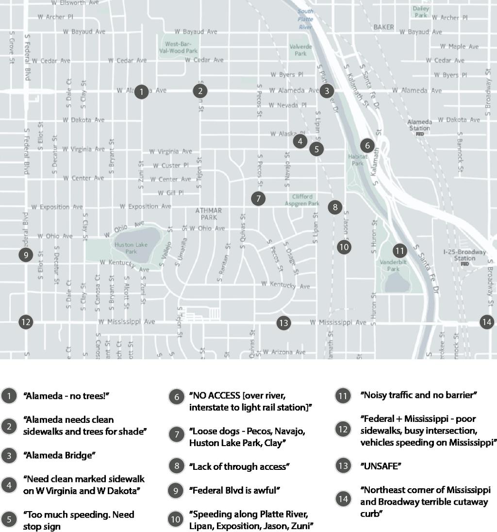
3 At a meeting of the Athmar Park Neighborhood Association on July 28 th, 2015, neighborhood residents provided additional input on the walkability of the neighborhood. Major findings from the walk audit and resident feedback include the following: The vast majority of the study area s sidewalks and intersections were rated as poor or mediocre. Overall, 88% of sidewalks and 87% of intersections were rated three or less on a five-point quality scale. The majority of sidewalks in the study area of 215 total one-block segments are less than three feet wide rollover curbs, which are too narrow for wheelchairs or strollers, and, as the name suggests, can be easily mounted by vehicles, resulting in parked vehicles obstructing the sidewalk. Missing crosswalks, high traffic speeds and volumes, wide crossing distances, and poor driver behaviors at intersections all add up to unsafe conditions for pedestrians crossing or walking along Alameda Ave. Problems with drivers speeding and/or drivers failing to yield to pedestrians were reported along Alameda Ave and Tejon St. Neighborhood residents identified Alameda Ave, Federal Blvd, and Mississippi Ave as unsafe and uncomfortable to walk along. Residents also expressed a need for better connections across the Platte River and I-25 at Alameda and near the Alameda light rail station. No sidewalks are present on the north and east sides of West-Bar-Val-Wood Park. 3

4 OVERALL QUALITY OF THE PEDESTRIAN ENVIRONMENT Data collectors rated each sidewalk and intersection on a scale of 1 (lowest quality) to 5 (highest quality). The average rating for both sidewalks and intersections was 2.3. Out of 215 total one-block sidewalk segments, 88% received a rating of 3 or less, and out of 68 total intersections, 87% received a rating of 3 or less. Sixty-two percent of sidewalks and 72% of intersections received a rating of 2 or less. Only 4% of sidewalks and zero intersections received a rating of 5. Lowest quality ratings were spread relatively evenly throughout the neighborhood, and the highest quality ratings were found along the perimeter of the large superblock in the middle of the study area, as well as in the area southwest of West-Bar-Val-Wood Park. Overall Quality Raings 5 0% 4% 4 13% 8% 3 15% 26% 2 44% 59% 1 13% 18% 0% 20% 40% 60% 80% Intersecions Sidewalks
 received the highest")
 and narrow detached sidewalks (7 of 215 sidewalks) were given moderate overall ratings.")
, which cannot accommodate wheelchairs or strollers and are designed so that vehicles can")
5 SIDEWALK QUALITY Four main factors related to the overall quality of sidewalks: sidewalk type, accessibility, safety, and pedestrian amenities. Sidewalk Type The neighborhood s rare five-feet-or-wider detached sidewalks (meaning sidewalks with a buffer separating them from the roadway, only 2 the 215 sidewalks surveyed) received the highest overall quality ratings by far, averaging 4.5. The neighborhood s wider attached sidewalks (13 of 215 sidewalks surveyed) and narrow detached sidewalks (7 of 215 sidewalks) were given moderate overall ratings. Narrower attached sidewalks (51 of 215 sidewalks) received an average rating of 2.6. The vast majority of the neighborhood is served by lessthan-three-feet rollover curbs (129 of 215 sidewalks), which cannot accommodate wheelchairs or strollers and are designed so that vehicles can roll up onto them, blocking the sidewalk. These rollover curbs received an average rating of only 2.2. Areas with no sidewalks (11 of 215 block faces) all received the lowest possible quality rating of one. Most of the study area south of Alameda (except for the perimeter of the large superblock) is served by narrow rollover curbs, and a mix of sidewalk types is found along and north of Alameda. Most block faces with no sidewalks are concentrated north and east of West-Bar-Val-Wood Park. Zuni St near Dakota Ave; 5-feet or more detached sidewalk; overall quality rating 5 (high) Dakota Ave near Raritan St; less than 3-ft rollover curb; overall quality rating 3 (moderate) Pecos St near Bayaud Ave; no sidewalk; overall quality rating 1 (low) Average Raing by Sidewalk Type Other 5-feet-or-more-detached Less-than-5-feet-detached 5-feet-or-more-ajached Less-than-5-feet-ajached Less-than-3-feet-rollover-curb No-sidewalk


6 The majority of the neighborhood s sidewalks are less than 3-ft rollover curbs, which are too narrow for wheelchairs or strollers and can be easily obstructed by parked vehicles or overgrown vegetation, such as this segment along Bryant St near Cedar Ave (overall quality rating of 1). 6
, cracked and uneven surfaces, and various other sidewalk problems (which data collectors could specify) generally were associated with lower overall quality ratings.")
7 Accessibility Sidewalks with accessibility issues, including obstructions (poles, dumpsters, parked cars, overgrown vegetation, etc.), cracked and uneven surfaces, and various other sidewalk problems (which data collectors could specify) generally were associated with lower overall quality ratings. For sidewalks receiving a quality rating of 1 or 2 (lowest ratings), data collectors reported that 16% had obstructions, 12% were cracked or uneven, and 15% had other problems. For sidewalks receiving a quality rating of 4 or 5, data collectors reported that only 8% had obstructions and none were cracked/uneven or had other problems. Overall, data collectors reported that 13% of sidewalks surveyed had obstructions, 8% had cracked or uneven surfaces, and 11% had other problems. The majority of these accessibility problems are concentrated in the northern portion of the study area, though problems are also scattered throughout the rest of the study area. 7
.")

8 Safety Low sidewalk quality ratings were also somewhat correlated with safety concerns related to the volume or speed of traffic, poor lighting or visibility, or other safety problems (which data collectors could specify). For the sidewalks that received a quality rating of 1 or 2, data collectors reported that 24% had unsafe lighting or visibility, 13% had unsafe traffic speeds or volumes, and 7% had other safety problems. For sidewalks that received a quality rating of 4 or 5, data collectors reported that none had unsafe lighting or visibility, 12% had unsafe traffic speeds or volumes, and 4% had other problems. Overall, data collectors reported that 27% of the sidewalks surveyed had unsafe lighting or visibility, 10% had unsafe traffic speeds or volumes, and 5% had other safety problems. Concerns about poor lighting were most prevalent in the southern portion of the neighborhood, while concerns about unsafe traffic speeds or volumes were concentrated most heavily along Alameda Ave. 8
.")
9 Amenities The presence of sidewalk amenities, such as shade trees, quality landscaping, benches, or public art correlated with high overall quality ratings. For sidewalks rated 1 or 2, only 10% had shade trees, 4% had quality landscaping, and 1% had other amenities (includes benches, public art, or other amenities that data collectors could specify). By contrast, for sidewalks rated 4 or 5, 64% had shade trees, 64% had quality landscaping, and 8% had other amenities. Overall, data collectors reported that 28% of sidewalks surveyed had shade trees, 18% had nice landscaping, and 2% had benches, public art, or other amenities. Data collectors reported that sidewalk amenities were more densely concentrated in the northern and western parts of the neighborhood. * Multiple amenities indicates a combination of shade trees and nice landscaping, except in two instances where benches or public art were also marked as present. 9
, and pedestrian amenities.")
10 INTERSECTION QUALITY Four main factors related to the overall quality of intersections: driver behavior, traffic controls (crosswalks, traffic/pedestrian signals, or stop signs), the width of the crossing (number of lanes), and pedestrian amenities. Driver Behavior Instances of poor driver behavior (based on brief field observations by data collectors) also correlated with overall quality ratings. High intersection quality ratings were generally associated with better driver behavior. For intersections receiving a 4 or 5, data collectors reported zero driver behavior problems. By contrast, for intersections rated 1 or 2 (the lowest ratings), data collectors reported that drivers obeyed speed limits at just 71% of intersections, yielded to pedestrians at 90%, and obeyed traffic signals and stop signs at 98% of intersections. Overall, data collectors reported that drivers obeyed speed limits at 76% of intersections, yielded to pedestrians at 91%, and obeyed stop signs/traffic signals at 99% of intersections. Problems with driver behavior are somewhat prevalent along Alameda Ave and Tejon St. 10

11 Traffic Controls High intersection ratings were also associated with the presence of traffic controls, including marked crosswalks. Of the intersections receiving a rating of 4 or 5, 22% had marked crosswalks for all crossing directions. For intersections that were rated 1 or 2, only 4% had crosswalks. Overall, only 9% of intersections had marked crosswalks for all crossing directions, and 7% had crosswalks for some crossing directions. Traffic lights with pedestrian signals also were somewhat associated with higher overall ratings, as 11% of intersections rated 4 or 5 possessed traffic lights and pedestrian signals, while just 4% of the intersections rated 1 or 2 did. Finally, stop signs, or at least all-way stops, correlated with higher overall ratings. All-way stops were present at 33% of intersections rated 4 or 5 and only 8% of intersections rated 1 or 2. All-way stops were found at 18% of intersections overall. Crosswalks are mostly located along Tejon St next to the schools, Pecos St, and along Alameda Ave at signalized intersections. However, many of the intersections along these busier streets are missing crosswalks, making them difficult and dangerous to cross, especially Alameda, which is by far the busiest and widest street in the study area. 11


.")
12 Crossing Distance Wide crossing distances (6-7 lanes) make crossing Alameda Ave dangerous, even in locations where crosswalks are present, such as this intersection at Alameda and Yuma St The number of lanes to cross at each intersection (defined as the count of traffic lanes and turn lanes for the widest street at each intersection) also somewhat correlated with overall intersection ratings. For intersections rated 1 or 2, the average number of lanes to cross was 2.5. For intersections rated 4 or 5, the average number of lanes to cross was 2.0. The vast majority of intersections in the study area have only 2 lanes to cross. Wider crossings are located only along Alameda Ave, which has 6 lanes at most intersections (3 westbound lanes, 2 eastbound lanes, and a center/left turn lane), and one intersection with an additional right turn lane (totaling 7 travel lanes). Three of these intersections are unsignalized and do not have crosswalks, creating a dangerous situation for pedestrians. 12


13 Intersection Amenities Pedestrian amenities at intersections can include curb ramps, bulb-outs/curb extensions, and median island refuges. Only curb ramps are present in the Valverde study area. The presence of curb ramps was somewhat associated with higher overall quality ratings at intersections. For intersections rated 1 or 2, 78% had curb ramps, while 89% of intersections rated 4 or 5 had curb ramps. Overall, data collectors reported that 81% of intersections surveyed had curb ramps. Though curb ramps are present at most intersections, they often are not present at every corner and may connect to toonarrow sidewalks, such as at Bryant St and Virginia Ave. 13

14 COMMUNITY INPUT At an Athmar Park Neighborhood Association meeting on July 28 th, 2015, neighborhood residents provided input on the walkability of the neighborhood. Residents placed colored dots on a map indicating neighborhood destinations they like to or would like to walk to; drew lines on a second map to mark routes they like to walk along or would like to walk along, if improved; and placed sticky notes on a third map to explain barriers that discourage them from walking in the neighborhood. Overall, the community s feedback indicated a high number and diversity of walking destinations throughout the neighborhood, and it highlighted the need for improvement along many walking routes, especially along major arterials. Given the small number of residents who participated (approximately 20), responses may not be representative of the community as a whole. Destinations The most popular destination for neighborhood residents to walk to include the various parks in the area as well as retail and restaurants along Federal Blvd, Alameda, and other locations. 14

. Barriers Residents also used sticky notes to identify and explain barriers that discourage them from walking in the neighborhood.")
15 Routes Residents used colored highlighters to draw routes they currently like to walk along as well as routes they would like to walk along, if improved. A number of residents indicated they like to walk many of the quieter residential streets throughout the neighborhood as well as around the various parks. Routes that residents would like to walk along, if improved, include along Alameda Ave, Federal Blvd, Mississippi Ave, and across the Platte River and I-25 to the Alameda LRT Station (where no pedestrian connection currently exists). Barriers Residents also used sticky notes to identify and explain barriers that discourage them from walking in the neighborhood. Common themes that emerged from residents feedback include the following: Major arterials in the vicinity (Alameda, Federal, Mississippi, and Broadway) are unsafe and uncomfortable to walk along. Residents desire better connections across the Platte and I-25 at Alameda and near the Alameda light rail station Speeding traffic is common on several streets in the area, including Mississippi, Platte River Dr, Lipan St, Exposition Ave, Jason St, and Zuni St. 15
16 16

17 RECOMMENDATIONS Based on the WALKscope walk audit and community input, WalkDenver offers the following recommendations for improving pedestrian access to Valverde Elementary and other neighborhood destinations. 1. Transform Alameda Avenue into a more pedestrian and business friendly street 2. Transform Tejon Street into a priority pedestrian corridor for the neighborhood 3. Improve pedestrian access to the Alameda Light Rail Station 4. Use low-cost, interim design strategies. These recommendations are highlighted in the following map and discussed in further detail below. 17

18 1. Transform Alameda Avenue into a More Pedestrian and Business Friendly Street While pedestrian conditions are poor throughout the neighborhood surrounding Valverde Elementary, Alameda Avenue is clearly a critical pedestrian destination where not only the school is located, but also many shopping opportunities that residents wish to reach on foot. Alameda is also an important corridor for automobile traffic, carrying an average of 31,000 vehicles per day (CDOT, 2014). The following changes to Alameda Avenue would make the street safer and more comfortable for pedestrians, support businesses located along the corridor, and still accommodate current traffic volumes: Repair the sidewalks where they are significantly cracked and uneven. Add street trees and quality landscaping to provide shade, enhance the pedestrian microclimate and calm traffic. Alameda currently has sidewalks that are wider than many of the surrounding residential streets, but the corridor is noticeably lacking greenery. Add pedestrian-scale lighting to improve pedestrian safety at night. Eliminate the third west-bound travel lane (City data from 2009 indicate that traffic counts are actually higher in the east-bound direction), and repurpose this space for on-street parking and curb extensions at the intersections. On-street parking both supports local businesses and has a traffic calming effect, while curb extensions shorten crossing distances and increase visibility for pedestrians. Add crosswalks and traffic signals at Bryant St and Raritan St. These would each cut large (approx ft) gaps between crossing locations along Alameda in half. A rare section of Alameda Avenue with well-maintained sidewalks, street trees, and landscaping. 18
, destinations residents indicated they would like to be able to walk to.")

19 2. Transform Tejon Street into a Priority Pedestrian Corridor for the Neighborhood Tejon Street is another important corridor that connects Valverde Elementary to West-Bar-Val-Wood Park to the north and Huston Lake Park to the south (via Ohio Avenue), destinations residents indicated they would like to be able to walk to. Specific changes to make Tejon Street more pedestrian friendly include: Add sidewalks where they are currently missing and widen existing sidewalks to be at least 5 five feet wide. Narrow the travel lanes to calm traffic. Consider adding bicycle facilities. Add street trees and quality landscaping to provide shade, enhance the pedestrian microclimate and calm traffic. Add pedestrian-scale lighting to improve pedestrian safety at night. Add crosswalks where they are missing and extend the curbs at intersections near Valverde Elementary and West-Bar-Val-Wood Park to shorten pedestrian crossing distances and increase pedestrian visibility. Raise the crosswalks at these intersections to reinforce safe travel speeds and the residential nature of the street. Use artistic crosswalk designs to further increase visibility and contribute to the neighborhood s sense of place. Extended curbs and raised crosswalk. Source: NACTO Urban Street Design Guide Creatively designed crosswalks can help create a sense of place 3. Improve Pedestrian Access to the Alameda Light Rail Station Although located outside of the current study area, the Alameda Light Rail Station is clearly a high priority destination for neighborhood residents that, while not too far from Valverde Elementary, is difficult to reach on foot due to the challenges of crossing the Platte River, I-25, and the railroad tracks. Alameda Avenue, currently the only east-west access to the station, is extremely hostile to pedestrians in this area. The Alameda Station Area Plan (Denver Community Planning and Development, 2009) notes that improving east-west connectivity is an extremely important objective and identifies investment in bicycle/pedestrian bridges as an efficient 19
20 method to improve connectivity without the high cost and impacts of new streets. The plan recommends shared bicycle and pedestrian bridges from Alameda Station over the Consolidated Main Line alignment, I-25 and the Platte River, ultimately connecting to Virginia Avenue to the west. The plan also calls for separated 20

21 bicycle and pedestrian routes parallel to Alameda Avenue, between Cherokee and Lipan streets. 4. Use Low-Cost, Interim Design Strategies Recognizing that it may take several years to identify funding for and implement the changes outlined above, Primary Pedestrian Circulation Concept from the Alameda Station Area Plan. 21

22 the City can deploy low-cost, interim strategies to test out some of the design concepts in the near term. For example, sidewalks and curbs can be temporarily expanded using materials such as epoxied gravel, planter beds, and bollards. Interim sidewalk widening. Source: NACTO Urban Street Design Guide 22
Safe Routes to School: Munroe Elementary Walk Audit Report. Image: Drexel, Barrell & Co.
 Safe Routes to School: Munroe Elementary Walk Audit Report Image: Drexel, Barrell & Co. April 12, 2016 OVERVIEW As part of the 2014/2015 Denver Safe Routes to School (SRTS) Program, WalkDenver coordinated
WALKscope Data Challenge Tip Sheet
 WALKscope Data Challenge Tip Sheet Help us map where sidewalks end and win prizes for your neighborhood! WalkDenver & Denver Environmental Health (DEH) s Community Active Living Coalition (CALC) are proud
Agenda. Overview PRINCE GEORGE S PLAZA METRO AREA PEDESTRIAN PLAN
 PRINCE GEORGE S PLAZA METRO AREA PEDESTRIAN PLAN May 28, 2008 Agenda Welcome and introductions Project overview and issue identification Planning context and strengths Design challenges and initial recommendations
Why Zone In on Speed Reduction?
 Learn it. Do it. Live it! SPEED REDUCTION IN THE ZONE Why Zone In on Speed Reduction? Speeding is a serious issue that plays a major role in the risk of serious injury and pedestrian fatality in a crash.
COWETA HIGH SCHOOL AND EAST HIGHWAY 51
 COWETA HIGH SCHOOL AND EAST HIGHWAY 51 Lack of sidewalks along Ben Lumpkin Rd. Lack of crosswalks and ramps at intersection. Hwy 51 is wide to cross as a pedestrian. No ADA compliance or connection to
PRINCE GEORGE S PLAZA METRO AREA PEDESTRIAN PLAN
 PRINCE GEORGE S PLAZA METRO AREA PEDESTRIAN PLAN May 28, 2008 Agenda Welcome and introductions Project overview and issue identification Planning context and strengths Design challenges and initial recommendations
Memo. Introduction. Memphis STP Pedestrian Sidewalk Project
 Memo Memphis STP Pedestrian Sidewalk Project To: Kyle Wagenshutz, City of Memphis From: Matthew Berkow, Collin Chesston, and Anne Eshleman, Alta Planning + Design Date: June 2014 Re: Photo Inventory Introduction
FOCUS AREA 1 - Alberta Avenue Pocket Park 3 (121 Ave and 92 St)
") FOCUS AREA 1 - Alberta Avenue Pocket Park 3 (121 Ave and 92 St) New benches Plant evergreen trees Widen existing sidewalk from 1.5m to 1.8m Marked crosswalk 1.8m wide sidewalk Add pedestrian oriented lights
FOCUS AREA 1 - Alberta Avenue Pocket Park 3 (121 Ave and 92 St) New benches Plant evergreen trees Widen existing sidewalk from 1.5m to 1.8m Marked crosswalk 1.8m wide sidewalk Add pedestrian oriented lights
SAFE ROUTES TO SCHOOL (SR2S)
") SAFE ROUTES TO SCHOOL (SR2S) In partnership with Burbank Unified School District (BUSD) & City of Burbank George Washington Elementary School Thomas Jefferson Elementary School John Muir Middle School
SAFE ROUTES TO SCHOOL (SR2S) In partnership with Burbank Unified School District (BUSD) & City of Burbank George Washington Elementary School Thomas Jefferson Elementary School John Muir Middle School
2014/2015 BIKE ROUTE PLAN 83 AVENUE PROTECTED BIKE LANE
 About the Project The City of Edmonton is planning a major bike route on the southside of Edmonton. The Strathcona Bike Route will connect the communities of Strathcona, Garneau and the University area,
Tonight is for you. Learn everything you can. Share all your ideas.
 Strathcona Neighbourhood Renewal Draft Concept Design Tonight is for you. Learn everything you can. Share all your ideas. What is Neighbourhood Renewal? Creating a design with you for your neighbourhood.
7/23/2017 VIA . Michael Hanebutt City of Sacramento Community Development Department 300 Richards Boulevard, 3 rd Floor Sacramento, CA 95811
 7/23/2017 VIA EMAIL Michael Hanebutt City of Sacramento Community Development Department 300 Richards Boulevard, 3 rd Floor Sacramento, CA 95811 RE: 65 th Street Apartments (DR17-220) Dear Mr. Hanebutt:
El Camino Real Specific Plan. TAC/CAC Meeting #2 Aug 1, 2018
 El Camino Real Specific Plan TAC/CAC Meeting #2 Aug 1, 2018 Land Use Alternatives Goals and Tradeoffs Parks & open space Housing Retail & services Civic spaces Parking Community gathering spaces 3 Alternatives
This page intentionally left blank.
 This page intentionally left blank. COMMUNITY Glenpool Community Overview Glenpool Glenpool is a city of nearly 12,000 residents located in Tulsa County southwest of Tulsa and Jenks. The city is growing
COMMUNITY MEETING AGENDA
 COMMUNITY MEETING AGENDA Welcome and Introductions SAFE Presentation Project Presentation Priorities Feedback Next Steps Q&A Santa Cruz Avenue Corridor Study 1 Santa Cruz Avenue Corridor Study Community
12/4/2016 VIA . RE: Grocery Outlet Del Paso (DR16-328)
") 12/4/2016 VIA EMAIL Ethan Meltzer, Assistant Planner City of Sacramento Community Development Department 300 Richards Blvd, 3 rd Floor Sacramento, CA 95811 RE: Grocery Outlet Del Paso (DR16-328) Dear Mr.
12/4/2016 VIA EMAIL Ethan Meltzer, Assistant Planner City of Sacramento Community Development Department 300 Richards Blvd, 3 rd Floor Sacramento, CA 95811 RE: Grocery Outlet Del Paso (DR16-328) Dear Mr.
C C C
 C-012-001 Thank you for your support for the creation of new public space and nonmotorized access between downtown and the waterfront through the Overlook Walk, the East-West Connections, and the Promenade.
5/7/2013 VIA . RE: University Village Safeway Expansion (P13-019)
") 5/7/2013 VIA EMAIL David Hung, Associate Planner Community Development Department, Current Planning Division City of Sacramento 300 Richards Boulevard, 3 rd Floor Sacramento, CA 95811 RE: University Village
5/7/2013 VIA EMAIL David Hung, Associate Planner Community Development Department, Current Planning Division City of Sacramento 300 Richards Boulevard, 3 rd Floor Sacramento, CA 95811 RE: University Village
Broad Street Bicycle Boulevard Design Guidelines
 Broad Street Bicycle Boulevard Design Guidelines Building from the strategies introduced in the 2013 Bicycle Transportation Plan and community input received thus far, City Transportation Staff have identified
This page intentionally left blank.
 This page intentionally left blank. COMMUNITY Coweta Community Overview Coweta Coweta, a residential community located in Wagoner County, is a suburb of Tulsa situated southeast of the metropolitan area
5/31/2016 VIA . Arwen Wacht City of Sacramento Community Development Department 300 Richards Blvd., 3 rd Floor Sacramento, CA 95811
 5/31/2016 VIA EMAIL Arwen Wacht City of Sacramento Community Development Department 300 Richards Blvd., 3 rd Floor Sacramento, CA 95811 RE: El Pollo Loco (P16-028) Dear Ms. Wacht: WALKSacramento has reviewed
Memo. Ocean Avenue Corridor Design Project Public Workshop #2 Summary
 Ocean Avenue Corridor Design Project Public Workshop #2 Summary The second public workshop for the Ocean Avenue Corridor Design Project was held on Wednesday, May 14, 2014 from, 6 to 8 pm at Lick Wilmerding
ALBERTA AVENUE WHAT WE HEARD REPORT BUILDING GREAT NEIGHBOURHOODS
 ALBERTA AVENUE WHAT WE HEARD REPORT BUILDING GREAT NEIGHBOURHOODS FEBRUARY 2019 EXECUTIVE SUMMARY Starting in 2019, Alberta Avenue will see the replacement and enhancement of its aging collector and local
2014/2015 BIKE ROUTE PLAN 83 AVENUE PROTECTED BIKE LANE
 About the Project 2014/2015 BIKE ROUTE PLAN The City of Edmonton is planning a major bike route on the south side of Edmonton. This bike route is one part of a plan to provide citizens with transportation
THE ALAMEDA CONCEPT DESIGN COMMUNITY MEETING 3. A Plan for The Beautiful Way JANUARY 28, 2010
 CONCEPT DESIGN COMMUNITY MEETING 3 JANUARY 28, 2010 AGENDA INTRODUCTION COMMUNITY INPUT ROADWAY STUDIES STREETSCAPE DESIGN STATIONS DISCUSSION SUMMARY AND DISCUSSION NEXT STEPS CLOSE INTRODUCTION SCHEDULE
ROUTE 81 CORRIDOR STUDY DESIGN CONCEPTS
 RT 81 Corridor Study CLINTON ROUTE 81 CORRIDOR STUDY DESIGN CONCEPTS View north on High Street, with potential improvements to the streetscape Draft Recommendations November 8 th, 2018 TOWN OF CLINTON
5. RUNNINGWAY GUIDELINES
 5. RUNNINGWAY GUIDELINES These guidelines should be considered collectively when making runningway decisions. A runningway is the linear component of the transit system that forms the right-of-way reserved
WELCOME. Thank you for joining us at the Second Public Workshop for the Carlsbad Pedestrian Master Plan. We look forward to receiving your feedback.
 City of Carlsbad Pedestrian Master Plan: WELCOME WELCOME Please Sign In Provide Input at Flip Charts Review Boards Presentation of Draft Plan Thank you for joining us at the Second Public Workshop for
Safe Streets. City of Lake Forest Park. March 21, 2017
 Safe Streets City of Lake Forest Park March 21, 2017 1 01 WELCOME 2 Agenda WELCOME WHAT IS THIS PROJECT? CONTEXT DRAFT CITYWIDE PROJECTS EXERCISE INTRODUCTION 3 02 WHAT IS THIS PROJECT? 4 WHAT IS THIS
5 CIRCULATION AND STREET DESIGN
 5 CIRCULATION AND STREET DESIGN This chapter describes circulation and streetscape improvements proposed for the Northwest Chico Specific Plan Area. It includes detailed design specifications for existing
Washington County SW Beaverton-Hillsdale Hwy. & SW Scholls Ferry Rd.
 Washington County SW Beaverton-Hillsdale Hwy. & SW Scholls Ferry Rd. SW Beaverton-Hillsdale Hwy. & SW Scholls Ferry Rd. Washington County The SW Beaverton-Hillsdale Hwy & SW Scholls Ferry Rd. focus area
City of Sammamish. Welcome. Issaquah-Fall City Road Improvements Project Phase I Design: 242nd Avenue SE to Klahanie Drive SE
 Welcome Welcome to the third community meeting for the Issaquah-Fall City Road Improvements Project. AGENDA 6:00 p.m. Welcome and sign-in 6:10 p.m. Presentation 6:50 p.m. Open house Learn about the roadway
Johnson Elementary School
 Johnson Elementary School Safe Routes to School Walking Audit and Recommendations WalkDenver Fall 2013 Johnson Elementary School 1850 South Irving Street, Denver 80219 This project was supported by Safe
Bicycle and Pedestrian Advisory Committee (BPAC) November 21, 2013
 November 21, 2013") Bicycle and Pedestrian Advisory Committee (BPAC) November 21, 2013 OVERALL LAND USE CONCEPT Overall Broadway Valdez District: 95.5 acres (35.1 acres right-of ways + 60.4 acres developable land) Plan Subareas:
Bicycle and Pedestrian Advisory Committee (BPAC) November 21, 2013 OVERALL LAND USE CONCEPT Overall Broadway Valdez District: 95.5 acres (35.1 acres right-of ways + 60.4 acres developable land) Plan Subareas:
Southview Blvd & 3 rd Avenue Improvement Project. Public Open House December 4, to 7pm
 Southview Blvd & 3 rd Avenue Improvement Project Public Open House December 4, 2014 5 to 7pm Southview Blvd & 3 rd Avenue Public Information Meeting Agenda Presentation 5:30 to 6:15 pm Purpose of Project
Duwamish Way-finding and CTR Report
 V. North Tukwila When the North Tukwila Manufacturing and Industrial Center was designated in 1992 as part of the region s land use and transportation plan, the plan called for the area to set a light-rail
Lee s Summit Road Improvement Study Public Open House June 7, 2007 Summary of Comment Card Responses
 Lee s Summit Road Improvement Study Public Open House June 7, 2007 Summary of Comment Card Responses Introduction At the Lee s Summit Road Improvement Study Public Open House held Thursday, June 7, 2007
City of Davis East Covell Corridor Plan
 Community Open House #2 January 22, 2014 6:00 8:00 p.m. Veterans Memorial Center, Club Room City of Davis Introduction The (ECCP) is a taking a comprehensive look at the existing transportation systems
5 Circulation & Parking
 5 Circulation & Parking Downtown Parking & Circulation Strategy. Downtown Wayne has a somewhat disconnected system of local public streets to connect downtown with the residential neighborhoods, and primary
Bikeway action plan. Bicycle Friendly Community Workshop March 5, 2007 Rochester, MN
 Bikeway action plan Summary The was held on March 5, 2007 at the Rochester Mayo Civic Center. The workshop was hosted by Rochester-Olmsted County Planning Department in collaboration with the League of
Draft North Industrial Area-Wide Traffic Plan
 Summary of North Industrial and Hudson Bay Industrial Recommended Improvements Table 1. Summary of s Item Location 1 2 3 4 5 6 7 8 9 10 11 12 Millar Ave north of 51st St Super 8 Motel back lane 400 Block
complete streets design and construction standards public primer City of Edmonton
 complete streets design and construction standards public primer City of Edmonton introduction Complete Streets are streets for everyone: people who walk, wheel, bike, take transit, or drive. They are
Figure 4-10: Pedestrian Improvements Types of Potential Station Area Improvements - Place-Making Improvements
 INCORPORATE FEATURE PAVIN IN CROSSWALK AND INTERSECTION FIELDS Identifies high-priority pedestrian areas and create a station identity through colorful and interesting patterns ADD CURB EXTENSIONS Extending
Report on Walkability Survey and Workshop for ZIP Code Hosted by the Oklahoma City-County Health Department April 13, 2013
 Report on Walkability Survey and Workshop for ZIP Code 73111 Hosted by the Oklahoma City-County Health Department April 13, 2013 On April 13th, the Oklahoma City-County Health Department hosted a community
CONNECTIVITY PLAN. Adopted December 5, 2017 City of Virginia Beach
 CONNECTIVITY PLAN Adopted December 5, 2017 City of Virginia Beach CONTENTS 1.0 Background & Purpose... 2 2.0 Existing Inventory & Analysis... 3 ViBe District Existing Walking Conditions... 4 3.0 ViBe District
PEDESTRIAN ACTION PLAN
 ATTACHMENT 2 CITY OF SANTA MONICA PEDESTRIAN ACTION PLAN CITY OF SANTA MONICA PEDESTRIAN ACTION PLAN This page intentionally left blank EXECUTIVE SUMMARY CHAPTER 1 EXECUTIVE SUMMARY Setting the Stage
CHAPTER 3: Vision Statement and Goals
 Davidson Walks & Rolls: Active Transportation Master Plan CHAPTER 3 Contents: Overview Vision Statement Measurable Goals Public Outreach CHAPTER 3: Vision Statement and Goals Overview The vision statement
FONTAINE AVENUE STUDY Final Report
 FONTAINE AVENUE STUDY Final Report March 28, 2005 FONTAINE AVENUE STUDY City of Charlottesville March 28, 2005 Renaissance Planning Group Kenneth Schwartz, FAIA, AICP Director of Design Leigh Wilkerson,
TRAFFIC ACTION PLAN. Laurie Meadows Neighborhood CITY OF SAN MATEO
 TRAFFIC ACTION PLAN Laurie Meadows Neighborhood CITY OF SAN MATEO Draft January 2017 Table of Contents Introduction... 2 The Traffic Forum Process... 5 Neighborhood Traffic Issues... 7 Neighborhood Recommendations
Pedestrian. Identifying Important Pedestrian Routes. 7 Pedestrian CHAPTER 7
 CHAPTER 7 Pedestrian T he City of Decatur is a prime location for walking. Historic houses, tree lined streets, a range of fine shopping and restaurants, and a conveniently small size all help create an
DOWNTOWN MIAMI PEDESTRIAN PRIORITY ZONE
 DOWNTOWN MIAMI PEDESTRIAN PRIORITY ZONE AUGUST 6, 2013 DOWNTOWN MIAMI BY THE NUMBERS more than 200,000 people live, work, and play here every day is home to more than 1,000 events each year hosts more
Active Transportation Facility Glossary
 Active Transportation Facility Glossary This document defines different active transportation facilities and suggests appropriate corridor types. Click on a facility type to jump to its definition. Bike
6/14/2013 VIA . Evan Compton, Associate Planner Community Development Department City of Sacramento 300 Richards Blvd Sacramento, CA 95814
 6/14/2013 VIA EMAIL Evan Compton, Associate Planner Community Development Department City of Sacramento 300 Richards Blvd RE: Sacramento Natural Foods Co-Op (P13-025) Dear Mr. Compton: WALKSacramento appreciates
If a person walks within this focus area, these are examples of the places he or she could walk to or from:
 Portland Hillsdale Hillsdale Portland The Hillsdale focus area is located in the City of Portland. It is situated approximately three miles from the City of Portland s downtown, 5.5 miles from the City
MARTIN LUTHER KING JR. WAY
 OCTOBER 2011 40 Vision and Goals The Martin Luther King, Jr. Way Illustrative Master Plan that follows has been developed through a process of community involvement. It expresses a long term vision for
11/3/2014 VIA . WALKSacramento has reviewed the Stockton and T Mixed-Use project at 3675 T Street in the
 11/3/2014 VIA EMAIL Antonio Ablog Planning Department City of Sacramento 300 Richards Boulevard Sacramento, CA 95811 RE: Design Review for Stockton and T Mixed-Use (P14-042) Dear Mr. Ablog: WALKSacramento
10/30/2012 VIA
 10/30/2012 VIA EMAIL David Hung, Associate Planner Community Development Department, Current Planning Division City of Sacramento 300 Richards Blvd., 3 rd Floor Sacramento, CA 95811 RE: The Cannery On-Site
A CHANGING CITY. of Edmonton, it is essential that it reflects the long-term vision of the City.
 A CHANGING CITY By the year 2040, Edmonton will be home to more than 1 million people. To accommodate growth and support a healthy and compact city, we need a new approach to development/redevelopment
City of Seattle Edward B. Murray, Mayor
 City of Seattle Edward B. Murray, Mayor Department of Transportation Scott Kubly, Director Eastlake Community Council 117 E Louisa St. #1 Seattle, WA 98102-3278 January 28, 2016 RE: Roosevelt to Downtown
122 Avenue: 107 Street to Fort Road
 : 107 Street to Fort Road November 24, 2015 4:30 8:00 p.m. Meeting Purpose Summarize project work completed to date Share results of public input from Phase 1 Share the draft concept plan and proposed
Outreach Approach RENEW SF served as the primary liaison with the North Beach community; the Chinatown. Executive Summary
 Executive Summary Executive Summary The Columbus Avenue Neighborhood Transportation Study s objective is to identify changes to transportation infrastructure and policies that could enhance the livability
8/31/2016 VIA . RE: Freeport Arco Fuel Station (P16-039)
") 8/31/2016 VIA EMAIL Garrett Norman, Assistant Planner City of Sacramento Community Development Department 300 Richards Boulevard, 3 rd Floor Sacramento, CA 95811 RE: Freeport Arco Fuel Station (P16-039)
8/31/2016 VIA EMAIL Garrett Norman, Assistant Planner City of Sacramento Community Development Department 300 Richards Boulevard, 3 rd Floor Sacramento, CA 95811 RE: Freeport Arco Fuel Station (P16-039)
What Is a Complete Street?
 Session 5 Charleen Zimmer, AICP, Zan Associates May 5-7, 2010 What Is a Complete Street? May 2010 5-1 Not a Complete Street More of a Complete Street May 2010 5-2 Benefits of Complete Streets Safety for
Use this guide to learn more about walkability and how you can make your community safer to walk
 Walkability Guide Do You Enjoy Walking In Your Community? Use this guide to learn more about walkability and how you can make your community safer to walk 2 About This Guide Circulate San Diego believes
Chapter 2: Standards for Access, Non-Motorized, and Transit
 Standards for Access, Non-Motorized, and Transit Chapter 2: Standards for Access, Non-Motorized, and Transit The Washtenaw County Access Management Plan was developed based on the analysis of existing
Table 1. Greatest Reductions in Traffic Volume
 Interstate MAX Light Rail Traffic Impact Summary Portland Office of Transportation October 2005 Summary The majority of streets after construction of the Interstate MAX light rail extension experienced
CURBSIDE ACTIVITY DESIGN
 5 CURBSIDE ACTIVITY DESIGN This chapter provides design guidance for separated bike lanes adjacent to curbside activities including parking, loading and bus stops. Typical configurations are presented
KEARNY MESA COMMUNITY PLAN UPDATE
 KEARNY MESA COMMUNITY PLAN UPDATE January 18, 2018 SUBCOMMITTEE MEETING Mobility Concepts and Urban Design Presentation Outline Mobility Concepts: Multimodal Planning Toolbox Presentation and Activities
9/21/2016 VIA . RE: The Knot (DR16-270)
") 9/21/2016 VIA EMAIL Garrett Norman, Assistant Planner City of Sacramento Community Development Department 300 Richards Boulevard, 3 rd Floor Sacramento, CA 95811 RE: The Knot (DR16-270) Dear Mr. Norman:
9/21/2016 VIA EMAIL Garrett Norman, Assistant Planner City of Sacramento Community Development Department 300 Richards Boulevard, 3 rd Floor Sacramento, CA 95811 RE: The Knot (DR16-270) Dear Mr. Norman:
10/8/2014 VIA . RE: CVS Pharmacy (P13-002) Revised August 2014
 Revised August 2014") 10/8/2014 VIA EMAIL David Hung, Associate Planner Community Development Department, Current Planning Division City of Sacramento 300 Richards Boulevard, 3 rd Floor Sacramento, CA 95811 RE: CVS Pharmacy
10/8/2014 VIA EMAIL David Hung, Associate Planner Community Development Department, Current Planning Division City of Sacramento 300 Richards Boulevard, 3 rd Floor Sacramento, CA 95811 RE: CVS Pharmacy
Byron Avenue. Public Meeting. Thursday June 16, Traffic Calming Design Sherbourne Road to Island Park Drive
 Byron Avenue Traffic Calming Design Sherbourne Road to Island Park Drive Public Meeting Thursday June 16, 2016 Our Lady of Fatima Parish 153 Woodroffe Avenue 6 9pm 1 Project Summary Area Projects Background
4/14/2017 VIA . Miriam Lim, Junior Planner City of Sacramento Community Development Department 300 Richards, 3 rd Floor Sacramento, CA 95811
 4/14/2017 VIA EMAIL Miriam Lim, Junior Planner City of Sacramento Community Development Department 300 Richards, 3 rd Floor Sacramento, CA 95811 RE: Mack & Franklin Development (P17-016) Dear Ms. Lim:
9/22/2014 VIA . RE: Butano Apartments Pre App (PAMP )
") 9/22/2014 VIA EMAIL Surinder Singh, Senior Planner Planning and Environmental Review Division Sacramento County 827 7th Street, Second Floor RE: Butano Apartments Pre App (PAMP2014-00012) Dear Mr. Singh:
9/22/2014 VIA EMAIL Surinder Singh, Senior Planner Planning and Environmental Review Division Sacramento County 827 7th Street, Second Floor RE: Butano Apartments Pre App (PAMP2014-00012) Dear Mr. Singh:
Ocean Park Boulevard Green Street Project Alternatives & Trade Offs
 Planning Commission March 4, 2009 Ocean Park Boulevard Green Street Project Alternatives & Trade Offs Purpose of Tonight s Meeting Review concept plans and options Provide input on alternatives and trade-offs
Vision: Traditional hamlet with an attractive business/pedestrian friendly main street connected to adjacent walkable neighborhoods
 N D. Focus Area II Vision: Traditional hamlet with an attractive business/pedestrian friendly main street connected to adjacent walkable neighborhoods Transit Road Focus Area II is located in the Hamlet
SETTINGS AND OPPORTUNITIES MOBILITY & ACCESS
 7 mobility & access how do people use el camino what is it like to drive on el camino/to park along el camino what is the pedestrian experience like what is the role of transit along the corridor what
Monroe Street Reconstruction
 Total participants: 45+ Monroe Street Reconstruction Cross Section Workshop Notes September 29, 2016, Wingra School Workshop Orientation, Technical and Functional Considerations: The workshop began with
o n - m o t o r i z e d transportation is an overlooked element that can greatly enhance the overall quality of life for the community s residents.
 N o n - m o t o r i z e d transportation is an overlooked element that can greatly enhance the overall quality of life for the community s residents. 84 Transportation CHAPTER 11 INTRODUCTION Transportation
About the Studio. Edward J. Bloustein School of Planning and Public Policy - Rutgers University
 About the Studio Edward J. Bloustein School of Planning and Public Policy - Rutgers University Purpose of studio: Help City of Bayonne apply for Safe Routes to School (SRTS) funding by producing a School
CLOSED. Highlights of the Final Concept Design:
 The final Concept Design is the result of many months of listening, learning, creating, balancing, and understanding different needs and viewpoints, as well as incorporating technical requirements and
Complete Street Analysis of a Road Diet: Orange Grove Boulevard, Pasadena, CA
 Complete Street Analysis of a Road Diet: Orange Grove Boulevard, Pasadena, CA Aaron Elias, Bill Cisco Abstract As part of evaluating the feasibility of a road diet on Orange Grove Boulevard in Pasadena,
Mission-Geneva Transportation Study Community Workshop 2 July 8, 2006
 Community Workshop 2 July 8, 2006 Small Group Workbook 1 Basic Improvements on Mission Street Streetscape. Pedestrian-scale lighting; landscaping; community art on utility boxes; more (possibly unique)
C/CAG. Sunnybrae Elementary School Walking and Bicycling Audit. San Mateo-Foster City School District JUNE 2013
 Sunnybrae Elementary School Walking and Bicycling Audit JUNE 2013 San Mateo-Foster City School District C/CAG City/County Association of Governments of San Mateo County SUNNYBRAE ELEMENTARY SCHOOL WALKING
Cherry Creek Transportation and Land Use Forum September 25, 2013 Meeting Summary
 Cherry Creek Transportation and Land Use Forum September 25, 2013 Meeting Summary I. LEAD-IN TO SMALL GROUP DISCUSSION, POLLING AND STEERING COMMITTEE/TECHNICAL TASK FORCE DISCUSSION The meeting began
NEIGHBORHOOD TRAFFIC CALMING POLICY
 NEIGHBORHOOD TRAFFIC CALMING POLICY I. PURPOSE The City of Kent continually strives to strengthen and protect its neighborhoods by improving the quality of life in residential areas. Traffic conditions
UPTOWN REGIONAL BIKE CORRIDORS PROJECT SAN DIEGO ASSOCIATION OF GOVERNMENTS
 UPTOWN REGIONAL BIKE CORRIDORS PROJECT SAN DIEGO ASSOCIATION OF GOVERNMENTS SUMMARY REPORT: COMMUNITY UPDATE MEETING February 6, 2014 6 8:30 p.m. Roosevelt Middle School Library 3366 Park Blvd, San Diego
11/28/2016 VIA
 11/28/2016 VIA EMAIL Ethan Meltzer, Assistant Planner City of Sacramento Community Development Department 300 Richards Blvd., 3 rd Floor Sacramento, Ca 95811 RE: Natomas Corporate Center Commercial Building
5 Transit & Traffic. Overview
 5 Transit & Traffic Overview Montgomery Place s roadways and overall traffic circulation are unique in the city due to the narrow streets and avenues with boulevards; however, no sidewalks or curbs in
8/1/2018 VIA . Darcy Goulart City of Rancho Cordova Planning Department 2729 Prospect Park Drive Rancho Cordova, CA 95670
 8/1/2018 VIA EMAIL Darcy Goulart City of Rancho Cordova Planning Department 2729 Prospect Park Drive Rancho Cordova, CA 95670 RE: Towne Place Suites by Marriott Hotel (DD9806) Dear Ms. Goulart: WALKSacramento
CURB EXTENSIONS BULB OUTS DPS 201 NECKDOWNS
 CURB EXTENSIONS BULB OUTS DPS 201 NECKDOWNS WHY WHEN & WHERE When Limited Sight Distance Pedestrians & Vehicles Vehicles and Signs Want to put two curb ramps in Discourage High speed turning High number
Columbia Pike Implementation Team (CPIT) Meeting
 Meeting") Columbia Pike Implementation Team (CPIT) Meeting November 30, 2010 Agenda Introductions / Purpose of Meeting Review of project goals Multimodal project: 10% street design between the curbs Discussion Multimodal
Columbia Pike Implementation Team (CPIT) Meeting November 30, 2010 Agenda Introductions / Purpose of Meeting Review of project goals Multimodal project: 10% street design between the curbs Discussion Multimodal
WALKABILITY CHECKLIST How walkable is your community?
 WALKABILITY CHECKLIST How walkable is your community? Everyone benefits from walking and other forms of active transportation. These benefits include: improved fitness, cleaner air, reduced risks of certain
LTAC: Katie Mencarini, Central & Hampton Roads streets and a fifteen minute debrief to discuss the findings. Participants walked along Mill Road
 Walkabout Summary On June 3, 2013, five participants met at Glen Allen Elementary School in Glen Allen, Virginia to take a closer look at the walking and biking network around the school. In addition to
Transportation Planning Division
 Transportation Planning Division Presentation Outline Study Tasks Recap of Previous Meetings Data Collected Focus Areas within Study Limits Design Principles Tool Box Recommended Concepts Schedule Moving
DRAFT FOR DISCUSSION PURPOSED ONLY, 10/26/13 MOBILITY PLAN UPDATE DESIGN TOOLBOX
 DRAFT FOR DISCUSSION PURPOSED ONLY, 10/26/13 MOBILITY PLAN UPDATE DESIGN TOOLBOX Tool #1: Bike Lane Portion of the roadway designated for preferential use by bicyclists. One-way facilities that typically
Bridgewater Complete Streets Prioritization Plan and Pedestrian Safety Assessment
 Bridgewater Complete Streets Prioritization Plan and Pedestrian Safety Assessment Presented by Luciano Rabito Manager of Complete Streets Presented to Bridgewater, MA Wednesday, April 26, 2017 6:30 P.M.
Pedestrian Project List and Prioritization
 To: Kyle Wagenschutz, City of Memphis CC: From: Anne Conlon and John Cock, Alta Planning + Design Date: December, 2014 Re: Project List Development (Task 3.1-3.2) and Project List Prioritization (Task
CLOSED. The draft concept design has been broken down into 5 categories for the purpose of this survey:
 Old Strathcona s neighbourhood renewal process is now at the draft concept design phase. Over the last several months, the city has been gathering local knowledge and resident input that has been used
NAPIER AVENUE PEDESTRIAN AND BICYCLE PLAN
 NAPIER AVENUE PEDESTRIAN AND BICYCLE PLAN Prepared By: DRAFT: 1/17/1 WHAT ARE WALKABILITY AUDITS AND WHY ARE THEY IMPORTANT? Walkability is important for a community and everyone benefits from walking.
MINERAL AVENUE CORRIDOR ASSESSMENT STUDY IMPLEMENTATION STRATEGY
 MINERAL AVENUE CORRIDOR ASSESSMENT STUDY IMPLEMENTATION STRATEGY INTRODUCTION City Personnel Sign-in Sheet Comment Forms Please Write Down Any Feedback INTRODUCTION List of Topics for Presentation Study