City of Jacksonville s Targeted Water Quality Monitoring Approach. Melissa M. Long, PE Fall Seminar 2017
|
|
|
- Madeleine Edwards
- 5 years ago
- Views:
Transcription

1 City of Jacksonville s Targeted Water Quality Monitoring Approach Melissa M. Long, PE Fall Seminar 2017
2 Goals and Objective Goals Identify Potential Water Quality Problem Areas Measure effectiveness of BMPs Document Pollutant Loading/trends Objective Water Quality Improvement Implementation of SWMP Procedures and practices Effective allocation of resources Cross Department Coordination
3 Tools Used to Evaluate Plan Existing monitoring Evaluate trends Nutrient load reductions Bacteria reductions Support ID of source causes Annual EMC Load Calculation Per WBID local annual rainfall during reporting year Draw on previous experience LSJR Nutrient BMAP Tributaries I & II Bacteria BMAP BPCP Align interlocal agreement with co-permittee Assessment Programs
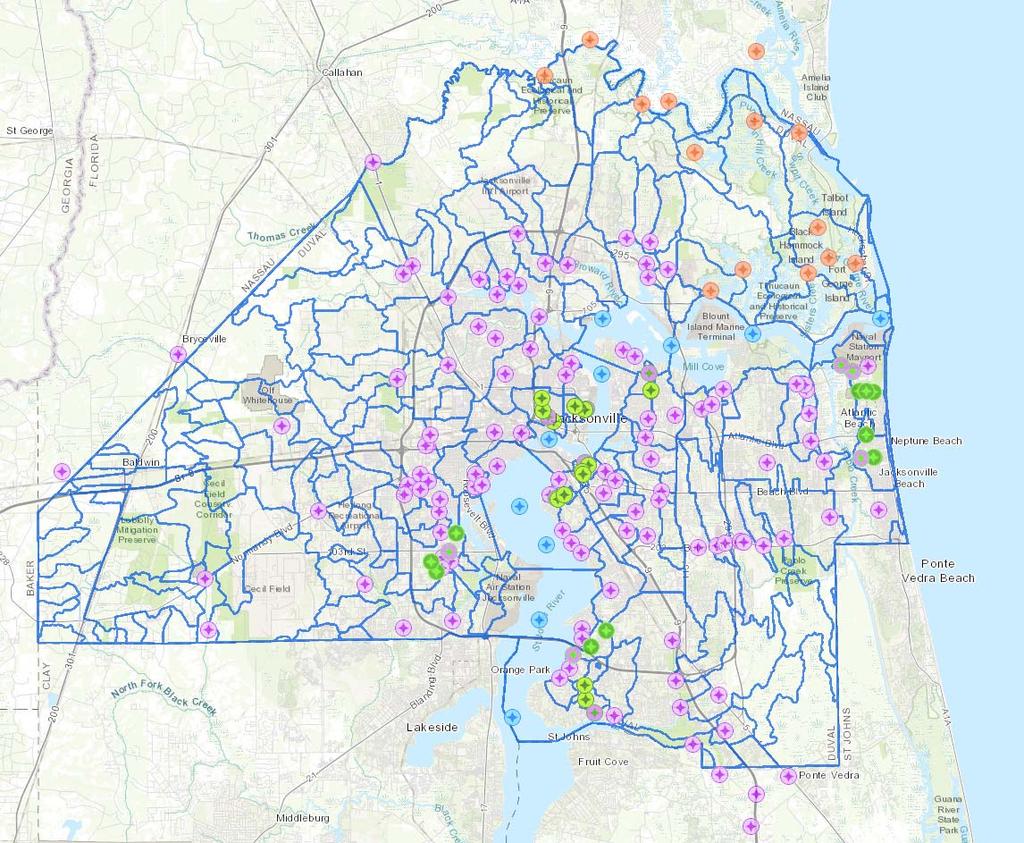
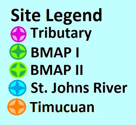
4 Ambient Water Quality Monitoring Current Monitoring St. Johns River (Main Stem) Tributaries Nassau and Ft. George Rivers Water Pollution Complaints Special Project Interagency Cooperation
5
6 How COJ will get there Long-term Fixed Station River Sampling Revised Fixed Station Tributary Monitoring Tributary FIB BMAP I & II Monitoring BPCP Monitoring Watershed Trend Monitoring Targeted Monitoring

7
8 Ambient vs MS4 PCODE WBID LOCATION LAT-Dec LONG-Dec ARL Stream Name Event Code Sandalwood Canal at Kernan Rd RT canal Comments Upstream of treatment pond (Paperclip Pond), CR427 is downstream CR Cedar River E. Branch at U.S RT Deep Bottom DBHartE 2361 Deep Bottom Creek, Creek BMAP2 Upstream of SWTF Deep Deep Bottom Creek, Northwest Bottom DBHartW 2361 Branch at Hartley Rd Creek BMAP2 Upstream of SWTF DBPine 2361 OR OR Deep Deep Bottom Creek Channel Near Headwaters Bottom Creek BMAP2 Upstream of SWTF Fishing Creek, South Branch at Fishing 118th Street Creek BMAP2 Upstream of SWTF Fishing Creek at Wesconnett Blvd RT Upstream of SWTF
9 Current Monitoring Parameters Field Parameters Laboratory Analysis Field Observations Water Temperature FIB Escherichia Coli Stream Appearance (fresh) ph FIB Enterococci (marine) Stream depth Specific Conductivity Dissolved Oxygen Salinity %DO Saturation Tidal Condition Meteorological Data Visual Oil & Grease Canopy Cover
10 Additional Parameters Total Nitrogen (TN) Total Kjeldahl Nitrogen (TKN) Nitrite & Nitrate (NO2/NO3) Total Phosphorus (TP) Biochemical Oxygen Demand (BOD5) Total Suspended Solids (TSS) Turbidity Chlorophyll a
11 Choosing Sites for Additional Tests Downstream of MS4 systems Near Major MS4 outfalls Tributary Intensive Study Sites Urban/Suburban sites
12 PCODE WBID LOCATION Latitude Longitude Stream Name ARL Red Bay Branch at Lone Star Rd Red Bay Branch ARL Strawberry Creek at Lone Star Rd Strawberry Creek BP B Big Pottsburg Creek at Hogan Rd Big Pottsburg Creek Big Pottsburg Creek Trib. (Leeds Pond) at BP Parental Home Rd Big Pottsburg Creek CR Butcher Pen Creek at Wesconnett Blvd Big Pottsburg Creek CR Wills Branch N. Branch at Old Middleburg Rd Wills Branch CR Cedar River E. Branch at Stuart Ave Cedar River E. Branch CR Little Fishweir Creek at Park St Little Fishweir Creek CR Williamson Creek at Hyde Park Rd Williamson Creek HC1A 2252 Hogan Creek at Broad St Hogan Creek JC Oldfield Creek at Julington Creek Rd Oldfield Creek LP Little Pottsburg Creek at Bedford Rd Little Pottsburg Creek MC McCoy Creek at Leland St McCoy Creek OR A Ortega River at Argyle Forest Blvd Ortega River SS Deep Bottom Creek at Scott Mill Rd Deep Bottom Creek SS21D 2287 Miller Creek West Branch behind shopping center Miller Creek SS Craig Creek in Park at Hendricks Ave Craig Creek SSGAD 2304 Miramar Creek Miramar Creek TR Little Sixmile Creek at Pickettville Rd Little Sixmile Creek TREE Trout River at Old Kings Rd Trout River COAB Sherman Creek, West Channel at Fleet Landing Blvd Sherman Creek COAB Puckett Creek at Assissi Lane Sherman Creek COAB4LS 2227 Sherman Creek, West Channel at Fleet Landing Blvd Sherman Creek IWWH 2266 Hopkins Creek at Kings Rd Hopkins Creek
13 FIB Evaluation
14 St. Johns River Nutrient Data
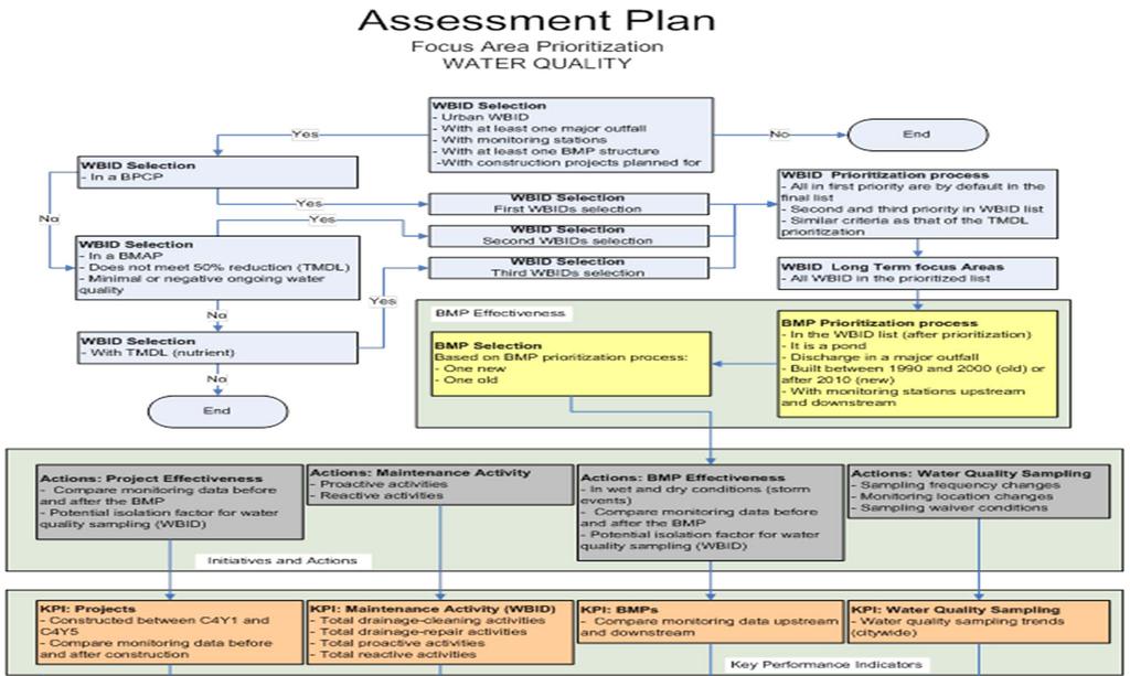
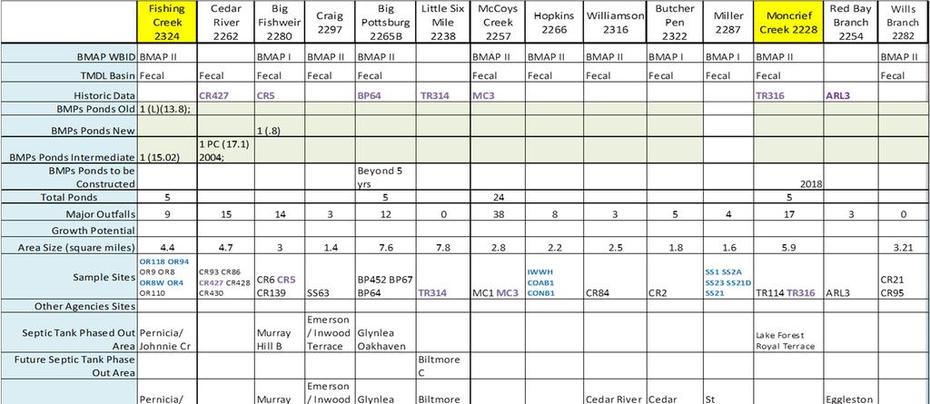
15 WBIDs Considered for Focus Area All impaired watersheds Fourteen impaired WBIDs were further evaluated Three primary criteria: Stormwater Treatment Ponds Historical Data Future BMPs Urban/Potential Growth
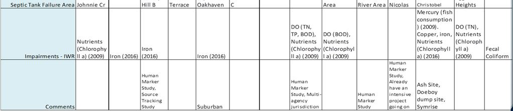
16 WBIDs Considered for Targeted Area

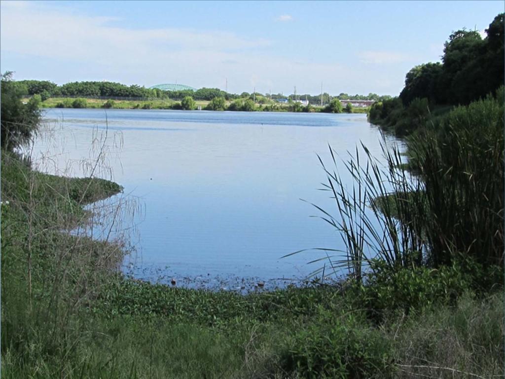
17 Moncrief Creek (WBID 2228)
18 Moncrief Creek Spring Grove Pond
19 Moncrief Creek Nutrients Trend Graph
20 Moncrief Creek FIB Trend Graph

21 Fishing Creek (WBID 2324)

22 Fishing Creek 118 th Street Pond
23 Fishing Creek Trend Graph


24 Overall Plan Submittal Part I Water Quality Monitoring and Trend Analysis (for all co-permittees)


25 Overall Plan - Submittal Part II SWMP Effectiveness Assessment Component (for COJ only)
26 Questions?
Site selection criteria. Stream selection criteria
 Duluth Urban Watersheds Project 2014-2016 Advisory Council 1-22, 2015 Stream selection criteria Impaired (MPCA/EPA) DNR Trout Stream designation Geographic distribution across Duluth Acceptable site available
LOWER ST. JOHNS RIVER REPORT APPENDICES BACKGROUND APPENDIX 1.A.
 LOWER ST. JOHNS RIVER REPORT APPENDICES BACKGROUND APPENDIX 1.A. TOTAL AREAS OF WETLAND AND DEEPWATER HABITATS St. Johns River Water Management District Wetland and Deep Water Habitat Maps (based on aerial
Mecklenburg County. Fish Consumption Advisories A Local Government Perspective
 Mecklenburg County Fish Consumption Advisories A Local Government Perspective David Caldwell Charlotte-Mecklenburg Storm Water Services Water Quality Program NCLMS October 4, 2012 Lake monitoring program
Total Suspended Solids, Stable Flow, and Wet Weather Event Monitoring in the Unnamed Tributary to the Grand River Watershed.
 Total Suspended Solids, Stable Flow, and Wet Weather Event Monitoring in the Unnamed Tributary to the Grand River Watershed December 2004 The Cadmus Group, Inc. Grand Valley State University Annis Water
Total Suspended Solids, Stable Flow, and Wet Weather Event Monitoring in the Bass River Watershed. December The Cadmus Group, Inc.
 Total Suspended Solids, Stable Flow, and Wet Weather Event Monitoring in the Bass River Watershed December 2004 The Cadmus Group, Inc. Grand Valley State University Annis Water Resources Institute Submitted
Water Quality Sampling Town River Bridgewater Haywood St
 Water Quality Sampling 2017 Town River Bridgewater Haywood St. 9-18-2017 Taunton River Bedford St., Route 18, Bridgewater 8-15-2017 The primary water quality problems in the watershed are excessive algae
SSO 700 Integrated Watershed Action Plan: Continuous Calibration of a Model
 SSO 700 Integrated Watershed Action Plan: Continuous Calibration of a Model 5 Cities Plus August 16, 2017 Presented by Matt Spidare, P.E MSDGC Victoria Berry, P.E. CH2M Overview of Presentation Project
NIANGUA SNAPSHOT ISSUE Nutrients 2 Suspended Sediment 3 Salinity 4 Summary 5
 Niangua River Watershed Snapshot Volume 14 Number 2 The 125-mile long Niangua River meanders northward from the town of Marshfield on I-44 to the Lake of the Ozarks. Its watershed covers more than 658,000
Creek. These SWWFs also represent important stakeholders in the protection and management of Big Walnut Creek.
 Creek. These SWWFs also represent important stakeholders in the protection and management of Big Walnut Creek. 5.0 WATER QUALITY ASSESSMENTS EXISTING AND CURRENT 5.1 IDEM Data A request was submitted to
APPENDIX A: Sources of Pollutants in Urban Areas.
 APPENDIX A: Sources of Pollutants in Urban Areas. Robert Pitt, Roger Bannerman, Shirley Clark and Derek Williamson Oversize tables from Chapters 23 and 24. 507 508 Oversize table from Chapter 23. Table
Exploring Localized Mixing Dynamics During Wet Weather in a Tidal Fresh Water System
 Exploring Localized Mixing Dynamics During Wet Weather in a Tidal Fresh Water System Ramona McCullough & Phil Duzinski Delaware Estuary Science & Environmental Summit January 27, 2015 Background and objectives
State of the Water. October 25, 2016 Union County Community Center
 State of the Water October 25, 2016 Union County Community Center What is a Watershed? Nashville Birmingham Atlanta Athens Etowah Cleveland Murphy Andrews Hayesville Copper Hill Blue Ridge Young Harris
Delaware River Basin Commission
 Delaware River Basin Commission Special Protection Waters: Lower Delaware Measurable Change Assessment DRBC Science and Water Quality Management Scenic Rivers Monitoring Program Water Quality Advisory
Schedule of Accreditation issued by United Kingdom Accreditation Service 2 Pine Trees, Chertsey Lane, Staines-upon-Thames, TW18 3HR, UK
 2 Pine Trees, Chertsey Lane, Staines-upon-Thames, TW18 3HR, UK Mohammed Abdulmohsin Al-Kharafi & Sons for General Trading, General Contracting & Industrial Structures W.L.L. trading as MAK Sulaibiya Testing
Upper Iroquois River atershed Management Plan
 2013 Upper Iroquois River atershed Management Plan Daniel M Perkins Jasper County Soil and Water Conservation District 12/30/2013 Table of Contents 1.1 WATERSHED COMMUNITY INITIATIVE... 12 1.2 Project
The Effects of Stream Adjacent Logging on Downstream Populations of Coastal Cutthroat Trout
 The Effects of Stream Adjacent Logging on Downstream Populations of Coastal Cutthroat Trout. D. S. Bateman 1, R.E. Gresswell 2, Aaron M. Berger 3, D.P. Hockman-Wert 4 and D.W. Leer 1 1 Department of Forest
EAST BAY/BLACKWATER BAY/LOWER YELLOW RIVER PRELIMINARY BASELINE RESOURCE CHARACTERIZATION
 EAST BAY/BLACKWATER BAY/LOWER YELLOW RIVER PRELIMINARY BASELINE RESOURCE CHARACTERIZATION With a Discussion of Flow-dependent Habitats and Species By F. Graham Lewis, Ph.D. Northwest Florida Water Management
Example Applications
 Example Applications The following example applications are intended to present how the tools developed for Trout Unlimited s Brook Trout Conservation Portfolio and Range-wide Assessment of Habitat Condition
Quassaick Creek. Watershed Management Plan. Advisory Committee Meeting #3 July 20 th, 2012
 Quassaick Creek Watershed Management Plan Advisory Committee Meeting #3 July 20 th, 2012 Assessment Report Subwatershed Delineation Characterizes watershed based on Hydrology/Topography (primary) Land
Lower Coquitlam River Project Water Use Plan. Temperature Monitoring Lower Coquitlam River Project Year 2 Report
 Lower Coquitlam River Project Water Use Plan Temperature Monitoring Lower Coquitlam River Project Year 2 Report COQMON#6 Temperature Monitoring Study Lower Coquitlam River Study Period: Year 2-2007 Report
Country report. Belgian bathing water quality in Belgium. May Photo: Peter Kristensen/EEA
 Country report Belgian bathing water quality in 2017 Belgium May 2018 Photo: Peter Kristensen/EEA BWD Report For the Bathing Season 2017 Belgium The report gives a general overview of information acquired
Water Quality Analysis of Total Phosphorus for the Lower Gunpowder Falls Watershed, Baltimore County, Maryland
 Water Quality Analysis of Total Phosphorus for the Lower Gunpowder Falls Watershed, Baltimore County, Maryland DEPARTMENT OF THE ENVIRONMENT 1800 Washington Boulevard, Suite 540 Baltimore MD 21230-1718
Suitable Applications Check dams may be appropriate in the following situations: To promote sedimentation behind the dam.
 Categories EC Erosion Control SE Sediment Control TC Tracking Control WE Wind Erosion Control Non-Stormwater NS Management Control Waste Management and WM Materials Pollution Control Legend: Primary Category
Eastern Brook Trout Joint Venture Annual Report The Nature Conservancy 2013
 Eastern Brook Trout Joint Venture Annual Report The Nature Conservancy 2013 2013 Annual Performance Report Enhancing Connectivity in the Ash-Black Rock Sub-basin of the West Branch Narraguagus River. Project
Assessment of Baseline Geomorphic Features at. Proposed Stream Crossings On The Proposed County Road 595. Marquette County, Michigan
 Assessment of Baseline Geomorphic Features at Proposed Stream Crossings On The Proposed County Road 595 Marquette County, Michigan Prepared for: Kennecott Eagle Minerals Company Marquette, Michigan Prepared
Blackstone River Coalition Watershed-wide Volunteer Water Quality Monitoring Program
 Blackstone River Coalition Watershed-wide Volunteer Water Quality Monitoring Program 9 th WQ Summit and Volunteer Appreciation Breakfast March 1, 2014 AGENDA 9:15 am Sign-in coffee and pastry 9:30 am Welcome
Notebooks or journals for drawing and taking notes
 Title: Have to Have a Habitat Grade Level: 5 th -8 th grade Topic: Trout Habitat Background: The following chart lists the ideal conditions for trout habitat. Dissolved Oxygen: > 7 mg/l ph: 5.5-7 Next
Regional Strategic Safety Plan PLANNING TO SAVE LIVES, TIME AND MONEY.
 2012 PLANNING TO SAVE LIVES, TIME AND MONEY. 2012 HUNDREDS OF NORTH FLORIDA RESIDENTS DIE IN TRAFFIC CRASHES ANNUALLY AND MORE PEOPLE DIE FROM TRAFFIC CRASHES THAN HOMICIDES. PLANNING TO SAVE LIVES, TIME
Final TMDL Report Fecal Coliform TMDLs for Trout River, WBIDs 2203A and 2203
 FLORIDA DEPARTMENT OF ENVIRONMENTAL PROTECTION Division of Environmental Assessment and Restoration, Bureau of Watershed Management NORTHEAST DISTRICT LOWER ST. JOHNS BASIN Final TMDL Report Fecal Coliform
FINAL Caples Lake Fisheries Management Plan. Version 4.0
 FINAL Caples Lake Fisheries Management Plan Version 4.0 August 15, 2008 Purpose The Caples Lake Fisheries Management Plan (Plan) outlines the stocking plan to reestablish a sport fishery in Caples Lake
Mill Creek/Rose Valley Watershed General Information Presented by Dr. Mel Zimmerman Lycoming College CWI
 Mill Creek/Rose Valley Watershed General Information Watershed Concerns Rose Valley Lake Areas of Interest Biodiversity of Interest in Rose Valley Lake Rose Valley Lake Bird Area Fishes of Rose Valley
located Let s go fishing Hydrilla
 Our Lake of the Month for November is Lake August (set your GPS to 27.2750-81.4136). The elevation of Lake August is 102.5. Lake August is a 52 acre dredge hole lake (man-made from a former wetland; see
Bathing Water Directive report The Czech Republic
 Bathing Water Directive report 2013 The Czech Republic The report gives a general overview of information acquired from the reported data, based on provisions of the Bathing Water Directive 1. The reporting
Minnesota Department of Natural Resources Division of Fish and Wildlife Section of Fisheries. Stream Survey Report. Cold Spring Creek.
 Minnesota F-29-R(P)-24 Area 315 Study 3 March 2015 Minnesota Department of Natural Resources Division of Fish and Wildlife Section of Fisheries Stream Survey Report Cold Spring Creek 2014 Mark Pelham Montrose
Distribution. PFBC Northcentral Region Law Enforcement Office, Attention: WCO Kraynak, 1150 Spring Creek Road, Bellefonte, PA 16823
 Distribution Pennsylvania Department of Environmental Protection, Northcentral Region Office, Attention: Steve Means, 208 West Third St. Suite 101, Williamsport, PA 17701 PFBC Northcentral Region Law Enforcement
Jason Blackburn, Paul Hvenegaard, Dave Jackson, Tyler Johns, Chad Judd, Scott Seward and Juanna Thompson
 Alberta Conservation Association (ACA) Date: 2014-2015 Project Name: Owl River Walleye and Aquatic Habitat Assessment Fisheries Program Manager: Peter Aku Project Leader: Tyler Johns Primary ACA staff
Potomac River Water Quality: Current Status & Trends
 Potomac River Water Quality: Current Status & Trends Tom Parham Maryland Department of Natural Resources November 13 th, 2014 Presentation Overview 2014 Chesapeake Bay Dissolved Oxygen Conditions Historic
Washington State Fish Passage Barrier Removal Projects. Casey Kramer, PE WSDOT State Hydraulics Engineer
 Washington State Fish Passage Barrier Removal Projects Casey Kramer, PE WSDOT State Hydraulics Engineer 2014 National Hydraulic Engineering Conference Iowa City, IA August 20 th, 2014 WSDOT Fish Passage
Refined Designated Uses for the Chesapeake Bay and Tidal Tributaries
 A-1 appendixa Refined Designated Uses for the Chesapeake Bay and Tidal Tributaries BACKGROUND Federal water quality standards regulations establish that states must specify appropriate water uses to be
California Health & Safety Code Requirement for Reporting of Sewage Spills
 Ocean Water Protection o Program OCCC 2007 Update Larry Honeybourne Health Care Agency Environmental Health Part 1: Sewage Spills and Closures Part 2: AB 411 Ocean & Bay Bacterial Monitoring Program Part
RAMP Objectives. RAMP Studies
 2008 Monitoring Results Fort Chipewyan, June 9, 2009 Presented by: Fred Kuzmic Wade Gibbons Martin Davies Heather Keith Hatfield Consultants. All Rights Reserved. 8/12/2009 SLIDE 1 What is RAMP? Initiated
Country report. Austrian bathing water quality in Austria. May Photo: Peter Kristensen
 Country report Austrian bathing water quality in 2016 Austria May 2017 Photo: Peter Kristensen BWD Report For the Bathing Season 2016 Austria The report gives a general overview of information acquired
Creek Trash Assessment (CTA) Methodology (Demonstration: Mill Run Creek, Cheltenham, Pa.)
 Methodology (Demonstration: Mill Run Creek, Cheltenham, Pa.)") Creek Trash Assessment (CTA) Methodology (Demonstration: Mill Run Creek, Cheltenham, Pa.) Mill Run Creek emerges from a storm sewer in Philadelphia to an open creek in Cheltenham. The Creek downstream
Creek Trash Assessment (CTA) Methodology (Demonstration: Mill Run Creek, Cheltenham, Pa.) Mill Run Creek emerges from a storm sewer in Philadelphia to an open creek in Cheltenham. The Creek downstream
2017 Annual Report: Survey pf American Alligators (Alligator mississippiensis) in the Big Thicket National Preserve. Summary.
 in the Big Thicket National Preserve. Summary.") 2017 Annual Report: Survey pf American Alligators (Alligator mississippiensis) in the Big Thicket National Preserve Matthew I. Pyne Assistant Professor, Department of Biology, Lamar University, P.O. Box
2017 Annual Report: Survey pf American Alligators (Alligator mississippiensis) in the Big Thicket National Preserve Matthew I. Pyne Assistant Professor, Department of Biology, Lamar University, P.O. Box
Minnesota Department of Natural Resources Division of Fish and Wildlife Section of Fisheries. Stream Survey Report. Three Mile Creek 2011
 Minnesota Department of Natural Resources Division of Fish and Wildlife Section of Fisheries Stream Survey Report Three Mile Creek 2011 By Joseph D. Stewig Montrose Area Fisheries Office TABLE OF CONTENTS
Removal of natural obstructions to improve Atlantic Salmon and Brook Trout habitat in western NL. 26/02/2015 Version 2.0
 Removal of natural obstructions to improve Atlantic Salmon and Brook Trout habitat in western NL 26/02/2015 Version 2.0 1 Table of Contents List of Tables... 2 Introduction... 3 Methods... 4 Preliminary
Resources and Guidance for writing a River Herring Management Plan
 Resources and Guidance for writing a River Herring Management Plan In 2011 members of the River Herring Network brainstormed a list of questions that should be answered in order to develop a plan for herring
Proposed Reclassification of Muskrat Creek, North Platte River Basin in Goshen County, Wyoming
 Proposed Reclassification of Muskrat Creek, North Platte River Basin in Goshen County, Wyoming October 25, 2010 Waterbody: Muskrat Creek - Mainstem of Muskrat Creek from its headwaters downstream to its
Salmon Biology Station
 Salmon Biology Station OBJECTIVES: Students learn: Wild salmon are indicator species and keystone species whose survival is connected to the health of the watershed. o Riparian salmon need trees and trees
INDIANA REGIONAL GENERAL CONDITIONS FOR THE STATE OF INDIANA
 INDIANA REGIONAL GENERAL CONDITIONS FOR THE STATE OF INDIANA These regional conditions are in addition to but do not supersede the requirements in the Federal Register (Volume 82 No. 4 of January 6, 2017).
3. The qualification raised by the ISRP is addressed in #2 above and in the work area submittal and review by the ISRP as addressed in #1.
 Please find attached a response from The Confederated Tribes of the Warm Springs Reservation of Oregon (CTWSRO) for Project # 2008-301-00, Habitat Restoration Planning, Design and Implementation within
Do upstream mining activities alter fish communities beyond a reference condition defined for the South Nahanni River and Nahanni National Park?
 Do upstream mining activities alter fish communities beyond a reference condition defined for the South Nahanni River and Nahanni National Park? David West 1, Paula Spencer 1,2, Troy Searson 2, Monique
Hard Hat Services ph: hardhatinc.com 932 N. Wright St., Suite 160 Naperville, IL 60563
 Interstate Power and Light Company Ottumwa Generation Station CCR Surface Impoundment Annual Inspection Report 154.018.012.003 Report issued: December 21, 2016 Hard Hat Services ph: 877-630-7428 hardhatinc.com
Hard Hat Services ph: hardhatinc.com 932 N. Wright St., Suite 160 Naperville, IL 60563
 Interstate Power and Light Company Ottumwa Generation Station CCR Surface Impoundment Annual Inspection Report 154.018.015.003 Report issued: July 03, 2017 Hard Hat Services ph: 877-630-7428 hardhatinc.com
ELIZABETH RIVER FACTS
 ELIZABETH RIVER FACTS How is she different from inland rivers? The Elizabeth River is an estuary a tidal finger of the Chesapeake Bay, rather than a freshwater river with a spring as origin. The Elizabeth
Colusa Basin Drain Watershed Fish Stranding Tour Concept Paper Mike Hendrick and Brycen Swart NMFS
 Colusa Basin Drain Watershed Fish Stranding Tour Concept Paper Mike Hendrick and Brycen Swart NMFS On May 31, 2013 representatives from CDFW, USFWS, and NMFS went on a field tour to look at locations in
Country report. Czech bathing water quality in Czech Republic. May Photo: Peter Kristensen
 Country report Czech bathing water quality in 2016 Czech Republic May 2017 Photo: Peter Kristensen BWD Report For the Bathing Season 2016 The Czech Republic The report gives a general overview of information
Temperature Profiling Within the Trout Creek Sub-Watershed 2013 Prepared by the Kennebecasis Watershed Restoration Committee January 2014
 Temperature Profiling Within the Trout Creek Sub-Watershed 2013 Prepared by the Kennebecasis Watershed Restoration Committee January 2014 A partnership project between the KWRC and Agriculture and Agri-Foods
CHAPTER 4 DESIRED OUTCOMES: VISION, GOALS, AND OBJECTIVES
 CHAPTER 4 DESIRED OUTCOMES: VISION, GOALS, AND OBJECTIVES Vision One of the first steps in developing this Plan was articulating a vision - a clear statement of what the Plan strives to achieve and what
FIU Digital Commons. Florida International University. Henry O. Briceño Florida International University,
 Florida International University FIU Digital Commons SERC Research Reports Southeast Environmental Research Center 2015 Water Quality Monitoring Project for Demonstration of Canal Remediation Methods Florida
The California Department of Fish & Game (D.F.G.) files indicate Big. Sulphur Creek has historically been a problem area as far as fish are
 files indicate Big. Sulphur Creek has historically been a problem area as far as fish are") scanned for KRIS The California Department of Fish & Game (D.F.G.) files indicate Big Sulphur Creek has historically been a problem area as far as fish are concerned. Before 1931, local people felt large
scanned for KRIS The California Department of Fish & Game (D.F.G.) files indicate Big Sulphur Creek has historically been a problem area as far as fish are concerned. Before 1931, local people felt large
Monitoring Cruise Report
 r/v Gunnar Thorson Monitoring Cruise Report Cruise no.: 214 Time: 1-19 February 23 Area: The Sound, the Kattegat, the Skagerrak, the North Sea, the Belt Sea and the Arkona Sea Ministry of the Environment
Fish Friendly Crossings- Examples from Nash Stream
 Fish Friendly Crossings- Examples from Nash Stream Maggie Machinist- North Regional Forester, Division of Forests and Lands. Nash Stream Nash Stream Forest is 40,000 acres, owned and managed by NH Division
Public Notice. Corps File No. LRE Date: March 19, 2017 Expires: March 18, 2022
 US Army Corps of Engineers Detroit District Public Notice Corps File No. LRE-2016-00006-100 Date: March 19, 2017 Expires: March 18, 2022 PUBLIC NOTICE ANNOUNCING REGIONAL CONDITIONS AND WATER QUALITY CERTIFICATIONS
UPPER GALLATIN TMDL PLANNING AREA BIOLOGICAL MONITORING
 UPPER GALLATIN TMDL PLANNING AREA BIOLOGICAL MONITORING Sampling and Analysis Plan Prepared for: BLUE WATER TASK FORCE, INC. Katie Alvin PO Box 160513 Big Sky, MT 59716 AND MONTANA DEPARTMENT OF ENVIRONMENTAL
2004 ANNUAL REPORT BOARD OF DIRECTORS
 2004 ANNUAL REPORT Enhancing and protecting the Upper Deschutes River watershed through collaborative projects in watershed stewardship, habitat enhancement, and community awareness. Dear Friends and Supporters,
Thanks to Burt Strom, Dick Pearce, and Ed Lombardo, Sr. for their help and information.
 The upper section of the Wood River that runs approximately two miles downstream from the bridge on State Route 165 contains a number of significant pools. Although the river is constantly changing through
Table VI-Proj SITE-SPECIFIC MANAGEMENT MEASURES FOR THE ROOT RIVER WATERSHED
 00216268.DOC 300-1104 MGH/JEB/pk 01/31/14, 02/04/14 Table VI-Proj SITE-SPECIFIC MANAGEMENT MEASURES FOR THE ROOT RIVER WATERSHED LRC-01 Habitat Hoods Creek entire length Village of Mt. Various Reiterate
Public Hearing October 21, 2014 University of North Florida Adam W. Herbert University Center Alumni Drive Jacksonville, FL 32224
 - Project Development & Environment Study from SR 9B to SR 202 (JTB Blvd.) Duval County, Florida Financial Project ID: 209301-3-22-01 Public Hearing October 21, 2014 University of North Florida Adam W.
Driftless Trout Resource Management. Vaughn Snook Assistant Fisheries Supervisor DNR Lanesboro Fisheries Office
 Driftless Trout Resource Management Vaughn Snook Assistant Fisheries Supervisor DNR Lanesboro Fisheries Office Topics Stocking Stream Easement Acquisition & Violation Review Habitat Improvement Projects
Tahquamenon River Assessment
 State owned land USFS land Superior Lower Falls USGS Gauging Station Superior Tahquamenon s Belle s Slater s Bass Betty B Dollarville Flooding Eckerman McMillan Mud East Kaks Twin McPhee s Hulbert Hulbert
Gallatin Watershed Restoration Prioritization Planning
 Final Report April 30, 2010 Gallatin Watershed Restoration Prioritization Planning Prepared for: Gallatin Conservation District Tony Thatcher DTM Consulting, Inc. 211 N Grand Ave, Suite J Bozeman, MT 59715
SOUTH CAROLINA ELECTRIC & GAS COMPANY COLUMBIA, SOUTH CAROLINA
 SOUTH CAROLINA ELECTRIC & GAS COMPANY COLUMBIA, SOUTH CAROLINA SALUDA HYDROELECTRIC PROJECT FERC NO. 516 DOWNSTREAM TEMPERATURE STUDY DRAFT REPORT MAY 28 Prepared by: SOUTH CAROLINA ELECTRIC & GAS COMPANY
Alberta Conservation Association 2013/14 Project Summary Report
 Project Name: Trout Stocking Evaluation Fisheries Program Manager: Peter Aku Project Leader: Kevin Fitzsimmons Primary ACA staff on project: Alberta Conservation Association 2013/14 Project Summary Report
Coquitlam/Buntzen Project Water Use Plan
 Coquitlam/Buntzen Project Water Use Plan Temperature Monitoring Lower Coquitlam River Project Year 3 Report Reference: COQMON#6 Study Period: March 2008 April 2009 Report Date: April 2009 Trow Associates
PROGRESS AS OF JUNE 25, 2010 ON COMPLETING A DISSOLVED OXYGEN MANAGEMENT PLAN/TMDL FOR THE NY/NJ HARBOR
 USEPA REGION 2 NY/NJ HARBOR ESTUARY PROGRAM Report PROGRESS AS OF JUNE 25, 2010 ON COMPLETING A DISSOLVED OXYGEN MANAGEMENT PLAN/TMDL FOR THE NY/NJ HARBOR June 2010 HRFO.001.019 1 CONTENTS Section Page
STREAM SURVEY File form No..
 scanned for KRIS THE RESOURCES AGENCY OF CALIFORNIA California Department of Fish and Game STREAM SURVEY File form No.. Date: September 4, 1969. NAME: North Fork Schooner Gulch Creek COUNTY: Mendocino.
Staying in Tune with South Florida s Water Cycle for Scientists, Managers, and Policy Makers in 5 Minutes per Week
 Staying in Tune with South Florida s Water Cycle for Scientists, Managers, and Policy Makers in 5 Minutes per Week Robert Sobczak (Big Cypress Nat l Pres), Todd Hopkins (FWS), Kevin Kotun (Everglades National
American Eels in Virginia Mountain Streams
 American Eels in Virginia Mountain Streams Andy Dolloff 1,Craig Roghair 1, Colin Krause 1, Dawn Kirk 2, Scott Smith 3, Andy Strickland 4 1 US Forest Service, Southern Research Station 2 GW-Jeff National
Conserving the Forests, Lakes and Streams of Northeast Michigan
 4241 Old US 27 South, Suite 2, Gaylord, Michigan 49735 (989) 448-2293 www.huronpines.org info@huronpines.org Prioritized Restoration Projects in the AuSable River Watershed Summer 2015 Update from Huron
1.Mill Creek Watershed Summary Description and Land Use
 1.Mill Creek Watershed Summary Description and Land Use Table xxx: Mill Creek Watershed Overview Watershed Size 31,435 acres/49.1 sq miles/ 127.1 sq km Elevation Range 5,594 feet [4,967-10,561] Stream
The activated sludge process
 The activated sludge process Most wastewater treatment plants are using the activated sludge process. The heart of such a process mainly consists of an aeration tank, a sedimentation tank or clarifier
Multiple Limiting Factors and Restoration of a Brook Trout Metapopulation
 Multiple Limiting Factors and Restoration of a Brook Trout Metapopulation J. Todd Petty and Brock M. Huntsman Steve Brown (WVDNR), Paul Kinder (NRAC), TJ Burr (NRCS) The Problem Extirpated from or highly
Executive Summary. Map 1. The Santa Clara River watershed with topography.
 Santa Clara River Steelhead Trout: Assessment and Recovery Opportunities December 2005 Prepared By: Matt Stoecker and Elise Kelley, Ph.D. University of California, Santa Barbara Prepared For: The Santa
NORTH RIVER FISH KILL PRELIMINARY REPORT 2014 SUMMARY
 NORTH RIVER FISH KILL PRELIMINARY REPORT 2014 SUMMARY A fish kill on Nor River was reported to e 1-800 Environmental emergency number on August 9, 2014. Representatives from e PEI Department of Environment,
Chesapeake Bay Commission September 7, 2012
 Chesapeake Bay Commission September 7, 2012 Mission: To protect, conserve, and enhance the Commonwealth s aquatic resources and provide fishing and boating opportunities Issues of concern Concerns over
What is a River Basin Restoration Priority? 1. Criteria for Selecting a Targeted Local Watershed (TLW) 2. Hiwassee River Basin Overview 3
 2. Hiwassee River Basin Overview 3") Hiwassee River Basin Restoration Priorities 2008 TABLE OF CONTENTS Introduction 1 What is a River Basin Restoration Priority? 1 Criteria for Selecting a Targeted Local Watershed (TLW) 2 Hiwassee River
Hiwassee River Basin Restoration Priorities 2008 TABLE OF CONTENTS Introduction 1 What is a River Basin Restoration Priority? 1 Criteria for Selecting a Targeted Local Watershed (TLW) 2 Hiwassee River
Bathing Water Directive report Bulgaria
 Bathing Water Directive report 2013 Bulgaria The report gives a general overview of information acquired from the reported data, based on provisions of the Bathing Water Directive 1. The reporting process
DRIPPING SPRINGS LAKE 5 YEAR LAKE MANAGEMENT PLAN
 DRIPPING SPRINGS LAKE 5 YEAR LAKE MANAGEMENT PLAN FISHERIES DIVISION CENTRAL REGION OKLAHOMA DEPTMENT OF WILDLIFE CONSERVATION PREPARED BY: DANNY BOWEN OCTOBER 2013 1 Background Dripping Springs Lake impounds
Summer Steelhead Surveys North Fork Trinity River Trinity County, California
 KRIS edition Summer Steelhead Surveys North Fork Trinity River Trinity County, California 1978-1997 By Loren Everest Fishery Biologist Weaverville Ranger District Shasta-Trinity National Forests October
Minnesota Department of Natural Resources Division of Fish and Wildlife Section of Fisheries. Stream Survey Report. Luxemburg Creek.
 Minnesota F-29-R(P)-24 Area 315 Study 3 March 2016 Minnesota Department of Natural Resources Division of Fish and Wildlife Section of Fisheries Stream Survey Report Luxemburg Creek 2015 Mark Pelham Sauk
Proposed Reclassification of Deer Creek, North Platte River Basin, Wyoming
 Proposed Reclassification of Deer Creek, North Platte River Basin, Wyoming October 25, 2010 Waterbody: Location: Tributary to: Deer Creek - Mainstem from headwaters downstream to the confluence with the
Indiana LTAP Road Scholar Core Course #10 Culvert Drainage. Presented by Thomas T. Burke, Jr., PhD, PE Christopher B. Burke Engineering, Ltd.
 Indiana LTAP Road Scholar Core Course #10 Culvert Drainage Presented by Thomas T. Burke, Jr., PhD, PE Christopher B. Burke Engineering, Ltd. Objectives Review culvert shapes, end sections, and materials
Minnesota Department of Natural Resources Lanesboro Area Fisheries Office FAQ sheet
 Minnesota Department of Natural Resources Lanesboro Area Fisheries Office FAQ sheet 1) Can you fish with minnows in designated trout streams? Possessing live minnows or using them for bait on designated
Raritan River Basin Nutrient TMDL Study
 Raritan River Basin Nutrient TMDL Study Funded By: Rutgers University New Jersey EcoComplex On Behalf of: New Jersey Department of Environmental Protection Division of Watershed Management August 17, 2004
2013 Electrofishing Program Summary. Miramichi Salmon Association In collaboration with the Department of Fisheries and Oceans
 2013 Electrofishing Program Summary Miramichi Salmon Association In collaboration with the Department of Fisheries and Oceans Prepared by: Alex Parker Biologist Miramichi Salmon Association 485, Route
INLAND FISHERIES: PAST, PRESENT AND FUTURE R. Welcomme
 INLAND FISHERIES: PAST, PRESENT AND FUTURE. 1950 1953 1956 1959 1962 1965 1968 1971 1974 1977 1980 1983 1986 1989 1992 1995 1998 2001 2004 2007 2010 Catch (tonnes 10 6 ) Inland fish catch by year 1950
Thomson River Basin May 2013
 Thomson River Basin May 2013 Introduction Southern Rural Water is the water corporation responsible for administering and enforcing the Thomson River Basin Local Management Plan (LMP). The purpose of the
Total Dissolved Gas Properties and Processes. by Mike Schneider US Army Corps of Engineers Engineer Research and Development Center
 Total Dissolved Gas Properties and Processes by Mike Schneider US Army Corps of Engineers Engineer Research and Development Center TDG Properties and Processes Scope of Discussion Physical Properties of
NEVADA DEPARTMENT OF WILDLIFE STATEWIDE SPORT FISHERIES MANAGEMENT
 NEVADA DEPARTMENT OF WILDLIFE STATEWIDE SPORT FISHERIES MANAGEMENT FEDERAL AID JOB PROGRESS REPORT F-20-49 2013 Urban Sport Fisheries SOUTHERN REGION NEVADA DEPARTMENT OF WILDLIFE, FISHERIES DIVISION ANNUAL