Site selection criteria. Stream selection criteria
|
|
|
- Emily Gilbert
- 5 years ago
- Views:
Transcription
1 Duluth Urban Watersheds Project Advisory Council 1-22, 2015 Stream selection criteria Impaired (MPCA/EPA) DNR Trout Stream designation Geographic distribution across Duluth Acceptable site available for stable, long-term hydrologic measurements Data useful for applying to other streams or for evaluating management activities Site selection criteria Absence of upstream and downstream obstructions Stable downstream control Straight section of stream Known channel dimensions (culvert, bridge) Suitable mounting locations for staff gauges and data loggers Presence of bridge or culvert for high flow measurements Proximity to stream discharge points Access from an adjacent road or trail Proximity to trails, public points of access or bus stops Permission from land owner and/or the public authority


2 MILLER CREEK Flow Station location: Between Michigan Street and Interstate 35 at 24th Ave. West; the box culvert on the east side of the Duluth Transit Authority (DTA) building.

3

4 LLO/NRRI-UMD (GLOS AOC) USGS- Scanlon & Nemadji Lake Superior NERR??? LLO-UMD IOOS I & II WQ sensors, T-profiles, weather NRRI-UMD 5 streams Q,T, EC25, turbidity LakeSuperiorstreams.org? LLO/NRRI/USGS Q,T, EC25, turbidity sensors GlobalGreatLakes.org Duluth Urban Area WRAPS Q, E. coli, Turbidity, color, Cl- Developed by: Updated: U6-m26-s4 USGS-Scanlon upriver: 2011 Q enhanced by T, ph, DO, EC25, turbidity
5 Flow & Water Quality Sampling Keene, Merritt, Miller, Chester, Tischer, and Amity Flow monitoring 5 minute data logging equipment installed Fall 2014 Water Quality Sampling design: Spring Fall ; 25 x per year Water Quality Field Parameters: Temperature Dissolved Oxygen (mg/l ; % saturation) ph Specific electrical conductance (EC25) 100 cm Secchi-tube reading (water clarity) Water level measurement, if at a gage station Stream photograph with field notes Water Quality Lab Parameters: E. coli Turbidity, TSS Color, Cl -, TP, TN, NO3/2-N, NH4-N (samples collected but analyses not funded as yet)


6 Sampling will start asap in Spring 2015 Awaiting Spring in Duluth Developed by: Updated: U6-m26-s6

, and www.lakesuperiorstreams.")

7 Automated in-stream sensors data logged every 5-15 minutes; may be manually or automatically (via modem) uploaded to MPCA database(s), and with its data visualization tools Flow, temperature, DO, specific conductivity (EC25), turbidity

")
 Staff")
8 Seasonal, event-based field measurements Secchi tube (clarity) Appearance (foam, color, ) Staff gauge (water depth/flow)


9 Grab sampling for E.coli, turbidity, TSS, Grab samples for E. coli are taken with sterile containers E. coli
 Developed by: Updated:")
10 Stream data visualization & animation: Rain storms & flashy trout streams ( infrastructure ) Developed by: Updated: U6-m26-s10


11 Kingsbury Zoo Tischer Mt.Royal Let s follow some drops of water (6/19-20/2012) Amity Bridge #1 Chester CSS


12 Stream data visualization tool: How quickly road runoff gets into the streams Tischer Chester Kingsbury Higher salt level = higher electrical conductivity (Look for darker blue to magenta changes) Chronic toxicity to brook trout Developed by: Updated: U6-m26-s12

13 Spring runoff weeks of salt exceeding chronic adult brook trout criterion = chronic toxicity to brook trout Developed by: Updated: U6-m26-s13


14 Science based: good data knowledge good decisions Link: text book learning to real data to how you can help fix it Developed by: Updated: U6-m26-s14


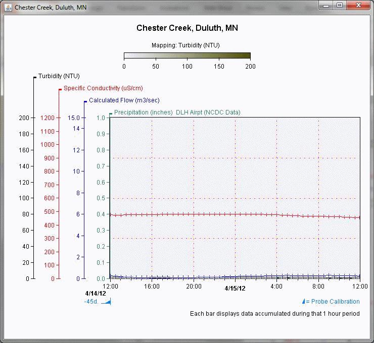
15 Chester Creek Flow Station located at W College St (St Scholastica bridge). The creek runs relatively straight and flat and is absent of upstream and downstream obstructions and appears to include a stable downstream control. The culvert provides well defined channel dimensions, is suitable for mounting equipment and measuring high flow and is accessible from the street.


16 Keene Creek Flow Station located at the box culvert on West 57th Ave. downstream side, on the southwest corner of Irving Park. The creek runs relatively straight and flat at the culvert and is absent of upstream and downstream obstructions and includes a stable downstream control.


17 Tischer Creek Flow Station located on downstream side of 4 th St. The defined channel dimensions, equipment mounting suitability, and minimal channel obstructions. make this the best of the available options on Tischer.
 on Grand Ave.")


18 Merritt Creek Flow Station located at the box culvert (downstream side) on Grand Ave. The creek runs relatively straight and flat at the culvert and is absent of upstream and downstream obstructions and appears to include a stable downstream control. The culvert provides well defined channel dimensions, is suitable for mounting equipment and measuring high flow and is accessible from the street.


19 Amity Creek Flow Station located at Occidental Blvd. The creek runs relatively straight and flat and is absent of upstream and downstream obstructions and appears to include a stable downstream control. The culvert provides well defined channel dimensions, is suitable for mounting equipment and measuring high flow and is accessible from the street.
Total Suspended Solids, Stable Flow, and Wet Weather Event Monitoring in the Unnamed Tributary to the Grand River Watershed.
 Total Suspended Solids, Stable Flow, and Wet Weather Event Monitoring in the Unnamed Tributary to the Grand River Watershed December 2004 The Cadmus Group, Inc. Grand Valley State University Annis Water
City of Jacksonville s Targeted Water Quality Monitoring Approach. Melissa M. Long, PE Fall Seminar 2017
 City of Jacksonville s Targeted Water Quality Monitoring Approach Melissa M. Long, PE Fall Seminar 2017 Goals and Objective Goals Identify Potential Water Quality Problem Areas Measure effectiveness of
Total Suspended Solids, Stable Flow, and Wet Weather Event Monitoring in the Bass River Watershed. December The Cadmus Group, Inc.
 Total Suspended Solids, Stable Flow, and Wet Weather Event Monitoring in the Bass River Watershed December 2004 The Cadmus Group, Inc. Grand Valley State University Annis Water Resources Institute Submitted
Designated Trout Stream Additions Arrowhead Creek
 Designated Trout Stream Additions Arrowhead Creek A small reach of Arrowhead Creek was inadvertently left off the list of sections when the stream was originally designated. This designation would fill
Assessment of Baseline Geomorphic Features at. Proposed Stream Crossings On The Proposed County Road 595. Marquette County, Michigan
 Assessment of Baseline Geomorphic Features at Proposed Stream Crossings On The Proposed County Road 595 Marquette County, Michigan Prepared for: Kennecott Eagle Minerals Company Marquette, Michigan Prepared
Minnesota Department of Natural Resources Division of Fish and Wildlife Section of Fisheries. Stream Survey Report. Cold Spring Creek.
 Minnesota F-29-R(P)-24 Area 315 Study 3 March 2015 Minnesota Department of Natural Resources Division of Fish and Wildlife Section of Fisheries Stream Survey Report Cold Spring Creek 2014 Mark Pelham Montrose
Eastern Brook Trout Joint Venture Annual Report The Nature Conservancy 2013
 Eastern Brook Trout Joint Venture Annual Report The Nature Conservancy 2013 2013 Annual Performance Report Enhancing Connectivity in the Ash-Black Rock Sub-basin of the West Branch Narraguagus River. Project
CLYDE RIVER FISH KILL 2016 PRELIMINARY REPORT
 CLYDE RIVER FISH KILL 2016 PRELIMINARY REPORT November 2016 CLYDE RIVER FISH KILL PRELIMINARY REPORT, NOVEMBER 2016 SUMMARY A fish kill on Clyde River was reported to e Prince Edward Island Department
Upper Iroquois River atershed Management Plan
 2013 Upper Iroquois River atershed Management Plan Daniel M Perkins Jasper County Soil and Water Conservation District 12/30/2013 Table of Contents 1.1 WATERSHED COMMUNITY INITIATIVE... 12 1.2 Project
Creek Trash Assessment (CTA) Methodology (Demonstration: Mill Run Creek, Cheltenham, Pa.)
 Methodology (Demonstration: Mill Run Creek, Cheltenham, Pa.)") Creek Trash Assessment (CTA) Methodology (Demonstration: Mill Run Creek, Cheltenham, Pa.) Mill Run Creek emerges from a storm sewer in Philadelphia to an open creek in Cheltenham. The Creek downstream
Creek Trash Assessment (CTA) Methodology (Demonstration: Mill Run Creek, Cheltenham, Pa.) Mill Run Creek emerges from a storm sewer in Philadelphia to an open creek in Cheltenham. The Creek downstream
APPENDIX J HYDROLOGY AND WATER QUALITY
 APPENDIX J HYDROLOGY AND WATER QUALITY J-1 Technical Report on Airport Drainage, Northern Sector Airport and Ordinance Creek Watershed / Preliminary Creek Constructed Natural Channel Culvert J-2 Preliminary
WASHINGTON CONSERVATION DISTRICT STANDARD OPERATING PROCEDURE (S.O.P.)
") Page 1 of 18 Water Monitoring Program WASHINGTON CONSERVATION DISTRICT STANDARD OPERATING PROCEDURE (S.O.P.) No. 1 FLOW MONITORING Page 2 of 18 Water Monitoring Program Standard Operating Procedure No.
Page 1 of 18 Water Monitoring Program WASHINGTON CONSERVATION DISTRICT STANDARD OPERATING PROCEDURE (S.O.P.) No. 1 FLOW MONITORING Page 2 of 18 Water Monitoring Program Standard Operating Procedure No.
Tahquamenon River Assessment
 State owned land USFS land Superior Lower Falls USGS Gauging Station Superior Tahquamenon s Belle s Slater s Bass Betty B Dollarville Flooding Eckerman McMillan Mud East Kaks Twin McPhee s Hulbert Hulbert
TOP:001.3 U.S. Fish and Wildlife Service TECHNICAL OPERATING PROCEDURE
 TOP:001.3 March 12, 2015 U.S. Fish and Wildlife Service Marquette Biological Station 3090 Wright Street Marquette, Michigan 49855 U.S.A. and U.S. Fish and Wildlife Service Ludington Biological Station
Environmental Review and Permitting for Wild Trout
 Environmental Review and Permitting for Wild Trout Tom Shervinskie Wild Trout Summit Watershed Analysis Section August 26, 2017 Division of Environmental Services The mission of the Pennsylvania Fish and
Chinook Salmon Spawning Study Russian River Fall 2005
 Chinook Salmon Spawning Study Russian River Fall 2005 Sonoma County Water Agency 2150 West College Avenue Santa Rosa, California 95401 Prepared by David Cook - Senior Environmental Specialist March 27,
Ellis Y. Byeon, PE Bryan VanderGheynst, PE 1
 Ellis Y. Byeon, PE Bryan VanderGheynst, PE 1 Background Information: City of Trenton, Mercer County Assunpink Creek, Pond Run and Delaware River Lower 2.5 miles of the Assunpink Creek Lower 0.6 miles of
HEC 26 Aquatic Organism Passage Design Manual Evolution & Application
 HEC 26 Aquatic Organism Passage Design Manual Evolution & Application Sven Leon, P.E., Hydraulics Engineer Federal Highway Administration 2015 Alaska Fish Passage Meeting October 13 14, 2015 VTRC, Juneau,
Firth Creek Habitat Enhancement Project 1993
 Firth Creek Habitat Enhancement Project 1993 A. R. Langston December 1993 PWFWCP Report No. 77 The Peace/Williston Fish & Wildlife Compensation Program is a cooperative venture of BC Hydro and the provincial
Interim Guidance Fish Presence Absence
 Interim Guidance Fish Presence Absence Source: Forest Practices Act Guidance for Division 635 of the forest practices act dealing with stream classification when no fish surveys have been done (referenced
Hydraulic Modeling of Stream Enhancement Methods
 Hydraulic Modeling of Stream Enhancement Methods Matthew J. Curry John J. Levitsky Abstract Development within watersheds increases the amounts of runoff causing stream erosion and degradation of stream
Minnesota Department of Natural Resources Division of Fish and Wildlife Section of Fisheries. Stream Survey Report. Cold Spring Creek.
 Minnesota F-29-R(P)-24 Area 315 Study 3 March 2013 Minnesota Department of Natural Resources Division of Fish and Wildlife Section of Fisheries Stream Survey Report Cold Spring Creek 2012 Mark Pelham Montrose
TROUT CREEK WATERSHED (Second Year of Snowline Data)
") Extent of Snow Cover During the 2002 Spring Freshet For the TROUT CREEK WATERSHED (Second Year of Snowline Data) (Penticton Forest District) 1.0 INTRODUCTION The extent of snow cover over a watershed basin
Extent of Snow Cover During the 2002 Spring Freshet For the TROUT CREEK WATERSHED (Second Year of Snowline Data) (Penticton Forest District) 1.0 INTRODUCTION The extent of snow cover over a watershed basin
FINAL REPORT. Yonkers Creek Migration Barrier Removal Project Wonderstump Road Del Norte County. Submitted By:
 FINAL REPORT Yonkers Creek Migration Barrier Removal Project Wonderstump Road Del Norte County Submitted By: Del Norte County Community Development Department Yonkers Creek Migration Barrier Removal Project
Example Applications
 Example Applications The following example applications are intended to present how the tools developed for Trout Unlimited s Brook Trout Conservation Portfolio and Range-wide Assessment of Habitat Condition
Low-Flow Purging Procedure with MicroPurge basics Equipment. MP10 Bladder Pump Controller MP15 Control. MP30 Drawdown Meter.
 Low-Flow Purging Procedure with MicroPurge basics Equipment MP10 Bladder Pump Controller MP15 Control and Power Pack MP20 Flow Cell MP30 Drawdown Meter P.O. Box 326 Ann Arbor, MI 48106-326 USA 1-800-624-2026
State of the Water. October 25, 2016 Union County Community Center
 State of the Water October 25, 2016 Union County Community Center What is a Watershed? Nashville Birmingham Atlanta Athens Etowah Cleveland Murphy Andrews Hayesville Copper Hill Blue Ridge Young Harris
Technical Report Culvert A Hydraulic Analysis
 DATE: November 3, 2011 Technical Report Culvert A Hydraulic Analysis TO: FROM: RE: Jim Reiser, P.E. Project Manager Parsons Brinckerhoff, Inc. Kurt Killian, P.E., CFM Parsons Brinckerhoff, Inc. Design
Savannah River, Georgia and South Carolina
 Scope of Work for Use of the Fish Bypass at New Savannah Bluff Lock and Dam for the Savannah Harbor Expansion Project Monitoring and Adaptive Management Program Savannah River, Georgia and South Carolina
Minnesota Department of Natural Resources Division of Fish and Wildlife Section of Fisheries. Stream Survey Report. Luxemburg Creek.
 Minnesota F-29-R(P)-24 Area 315 Study 3 March 2016 Minnesota Department of Natural Resources Division of Fish and Wildlife Section of Fisheries Stream Survey Report Luxemburg Creek 2015 Mark Pelham Sauk
Temperature Profiling Within the Trout Creek Sub-Watershed 2013 Prepared by the Kennebecasis Watershed Restoration Committee January 2014
 Temperature Profiling Within the Trout Creek Sub-Watershed 2013 Prepared by the Kennebecasis Watershed Restoration Committee January 2014 A partnership project between the KWRC and Agriculture and Agri-Foods
Trip Report: Eagle Creek, Arizona
 Trip Report: Eagle Creek, Arizona 15-17 June 2009 Participants: Abraham Karam, Brian Kesner, and Mike Childs Native Fish Lab Marsh & Associates, LLC 5016 South Ash Avenue Suite 108 Tempe, Arizona 85282
Plan B Dam Breach Assessment
 Plan B Dam Breach Assessment Introduction In support of the Local Sponsor permit applications to the states of Minnesota and North Dakota, a dam breach analysis for the Plan B alignment of the Fargo-Moorhead
SALINITY AND DISSOLVED OXYGEN IN THE MISSISSIPPI RIVER GULF OUTLET NAVIGATION CHANNEL AND IN ADJACENT SURFACE WATERS,
 SALINITY AND DISSOLVED OXYGEN IN THE MISSISSIPPI RIVER GULF OUTLET NAVIGATION CHANNEL AND IN ADJACENT SURFACE WATERS, 2008-2012 Southeast Louisiana Flood Protection Authority-East Coastal Advisory Committee
Notebooks or journals for drawing and taking notes
 Title: Have to Have a Habitat Grade Level: 5 th -8 th grade Topic: Trout Habitat Background: The following chart lists the ideal conditions for trout habitat. Dissolved Oxygen: > 7 mg/l ph: 5.5-7 Next
Alberta Conservation Association 2013/14 Project Summary Report
 Project Name: Trout Stocking Evaluation Fisheries Program Manager: Peter Aku Project Leader: Kevin Fitzsimmons Primary ACA staff on project: Alberta Conservation Association 2013/14 Project Summary Report
Packwood Hydroelectric Project Barrier Analysis December 12, 2006
 Packwood Hydroelectric Project Barrier Analysis December 12, 2006 Study Area Natural barriers to upstream fish passage on Lake Creek at RM 1.03 and RM 1.95 Snyder Creek culvert under the Project tailrace
Hypolimnetic Oxygenation for Indian Creek Reservoir Restoration. Bill Faisst CA/NV AWWA Fall Conference October 22, 2014
 Hypolimnetic Oxygenation for Indian Creek Reservoir Restoration Bill Faisst CA/NV AWWA Fall Conference October 22, 14 Indian Creek Reservoir High desert lake Little runoff ~ acre foot volume Regulatory
Wisconsin s Citizen-Based Monitoring Partnership Program and Trout Unlimited Driftless Area Restoration Effort (TUDARE)
") Wisconsin s 2010-11 Citizen-Based Monitoring Partnership Program and Trout Unlimited Driftless Area Restoration Effort (TUDARE) TUDARE Stream Monitoring Sites Established in 2010-2011 Summary Prepared
Wisconsin s 2010-11 Citizen-Based Monitoring Partnership Program and Trout Unlimited Driftless Area Restoration Effort (TUDARE) TUDARE Stream Monitoring Sites Established in 2010-2011 Summary Prepared
Chemical and Biological Recovery from Acidic Deposition in the Honnedaga Lake Watershed
 Chemical and Biological Recovery from Acidic Deposition in the Honnedaga Lake Watershed Abstract Honnedaga Lake supports one of seven remaining heritage strains of brook trout designated by the State of
Job 1. Title: Estimate abundance of juvenile trout and salmon.
 STUDY PERFORMANCE REPORT State: Michigan Project No.: F-53-R-13 Study No.: 461 Title: Population dynamics of juvenile rainbow trout and coho salmon in Lake Superior tributaries Period Covered: April 1,
Government of Newfoundland and Labrador Department of Environment and Conservation Water Resources Management Division
 Government of Newfoundland and Labrador Department of Environment and Conservation Water Resources Management Division Real Time Water Quality Monthly Report Leary s Brook- St. John s NL April 2009 General
Fish Friendly Crossings- Examples from Nash Stream
 Fish Friendly Crossings- Examples from Nash Stream Maggie Machinist- North Regional Forester, Division of Forests and Lands. Nash Stream Nash Stream Forest is 40,000 acres, owned and managed by NH Division
Section 10 - Hydraulic Analysis
 Section 10 - Hydraulic Analysis Methodology Documentation Functionality Summary Sizing Methodology Fixed/Resize Combined Flow Storm: Sizing as per d/d Structures.dat Storm vs. Sanitary Methodology HGL/EGL
Sampling Equipment Catalog. MicroPurge Low-Flow Pump Control
 MicroPurge Low-Flow Pump Control Sampling Equipment Catalog 10 MicroPurge Controls The MicroPurge Controller (U.S. Patent Number 6,508,310) revolutionizes low-flow sampling with advanced logic control
Evaluation copy. Interdependence of Plants and Animals. computer OBJECTIVES MATERIALS
 Interdependence of Plants and Animals Computer 14 Plants and animals share many of the same chemicals throughout their lives. In most ecosystems, O 2, CO 2, water, food and nutrients are exchanged between
Small Footprint Topo-Bathymetric LiDAR
 May 8, 2013 Small Footprint Topo-Bathymetric LiDAR PNAMP Remote Sensing Forum Russ Faux, Co-CEO, WSI Amar Nayegandhi, Manager of Elevation Technologies, Dewberry Colin Cooper, Senior Analyst, WSI Watershed
Climate Change Impacts on Great Lakes Fishes
 Climate Change Impacts on Great Lakes Fishes Stuart A. Ludsin ludsin.1@osu.edu Changing Climate Webinar Series The Ohio State University 19 April 2011 Today s Presentation Great Lakes Fish Community A
SUMMARY REPORT FOR LAKE ST. MALO FISHERIES ASSESSMENT. Prepared for the St. Malo and District Wildlife Association
 SUMMARY REPORT FOR LAKE ST. MALO FISHERIES ASSESSMENT Prepared for the St. Malo and District Wildlife Association Presented by August 25, 2014 Study dates thus far: Date Tasks February 16 Fishing derby;
Chapter 11. Culverts and Bridges Design Checklist for Culvert Design
 Yes No N/A Design Requirements I. GENERAL DESIGN GUIDELINES Chapter 11. Culverts and Bridges A. Culvert design is in accordance with the Culverts chapter of Volume 2 of the UDFCD Manual for additional
FISH 415 LIMNOLOGY UI Moscow
 FISH 415 LIMNOLOGY UI Moscow Sampling Equipment Purpose: - to familiarize you with limnological sampling equipment - to use some of the equipment to obtain profiles of temperature, dissolved oxygen, conductivity
Michigan Dept. of Natural Resources Status of the Fishery Resource Report Page 1. Weber Lake Cheboygan County, T34N, R3W, Sec.
 Michigan Dept. of Natural Resources 2012-143 Status of the Fishery Resource Report Page 1 Weber Lake Cheboygan County, T34N, R3W, Sec. 31 Neal Godby, Fisheries Biologist Environment Weber Lake is a 28.5-acre
Minnesota Department of Natural Resources
 Minnesota Department of Natural Resources Fisheries Management DRAFT VERSION - PRELIMINARY DATA (AS OF 7/7/) Lake Name: Bloody Survey Type: Standard Survey DOW Number: -4- Survey ID Date: 7// Lake Identification
Big Spring Creek Habitat Enhancement and Fishery Management Plans
 Big Spring Creek Habitat Enhancement and Fishery Management Plans November 5, 2012 Big Spring Events and Activities Center Newville, PA Charlie McGarrell Regional Habitat Biologist Pennsylvania Fish and
Blue Thumb Test Procedures
 Blue Thumb Test Procedures Items to take to Creek with you: 1. DO Kit (with scissors & thermometer) 2. Sample Bottle 3. Secchi Disk 4. Clip Board (with pen, instructions, and data sheet) 5. Goggles, Gloves,
WMS 8.4 Tutorial Hydraulics and Floodplain Modeling HY-8 Modeling Wizard Learn how to model a culvert using HY-8 and WMS
 v. 8.4 WMS 8.4 Tutorial Hydraulics and Floodplain Modeling HY-8 Modeling Wizard Learn how to model a culvert using HY-8 and WMS Objectives Define a conceptual schematic of the roadway, invert, and downstream
Cold Small River. A Brief Ecological Description of this Michigan River Type
 Cold Small River A Brief Ecological Description of this Michigan River Type Cold Small River segments are defined (by the Michigan Department of Natural Resources, Fisheries Division) as typically having
Walker Creek Salmon Monitoring Program Watershed Map
 Watershed Map Hwy 1 Keys Creek Sonoma County Marin County Downstream extent of study area Laguna Lake Chileno Creek T o m a l e s B a y Sonoma County Frink Canyon Walker Creek Ma rshall-petaluma Rd Verde
Appendix A Photo Set
 Appendix A Photo Set Fish Habitat Inventory, Mattamy Richmond Lands, Spring 2009 Submitted To: Susan Murphy Mattamy Homes 123 Huntmar Drive Ottawa, Ontario K2S 1B9 KILGOUR & ASSOCIATES LTD. 1500 Bank Street,
Importance of Un-named tributaries to Brook Trout populations. Dr. Jonathan M. Niles
 Importance of Un-named tributaries to Brook Trout populations. Dr. Jonathan M. Niles PA Streams All streams of PA have a designated use - huge resource - 7,357 named streams: 33,687 total miles - 54,552
Discussion on the Selection of the Recommended Fish Passage Design Discharge
 Discussion on the Selection of the Recommended Fish Passage Design Discharge Introduction The provision of fish passage is a requirement for most proposed culvert and bridge installations in Alberta, depending
Product Specification
 Ultrasonic Cold Water Meter Body Part Number: HS0014-000 Model Number: RC15/HS-US0004-000-01 Overview The Ultrasonic Cold Water Meter Body is comprised of a pair of ultrasonic flow sensors and a DN15 polymer
Delaware River Basin Commission
 Delaware River Basin Commission Special Protection Waters: Lower Delaware Measurable Change Assessment DRBC Science and Water Quality Management Scenic Rivers Monitoring Program Water Quality Advisory
1. In Reach 3, Perry, Knox, Lowell, and Hooker have crossings identified. What are these?
 Round 3 Integration Plan Integration Plan Public Meeting Denver Urban Waterways Study Meeting Date: Location: Hosted by: Attendees: August 30 2016, 5:30-7:30pm Barnum Recreation Center City and County
PENNDRAIN.rep. HEC-RAS Version May 2005 U.S. Army Corp of Engineers Hydrologic Engineering Center 609 Second Street Davis, California
 HEC-RAS Version 3.1.3 May 2005 U.S. Army Corp of Engineers Hydrologic Engineering Center 609 Second Street Davis, California X X XXXXXX XXXX XXXX XX XXXX X X X X X X X X X X X X X X X X X X X XXXXXXX XXXX
USING A LABYRINTH WEIR TO INCREASE HYDRAULIC CAPACITY. Dustin Mortensen, P.E. 1 Jake Eckersley, P.E. 1
 USING A LABYRINTH WEIR TO INCREASE HYDRAULIC CAPACITY Dustin Mortensen, P.E. 1 Jake Eckersley, P.E. 1 Plum Creek Floodwater Retarding Structure No. 6 is located in an area of Kyle, Texas, that is currently
Culvert Design for Low and High Gradient Streams in the Midwest. Dale Higgins, Hydrologist Chequamegon-Nicolet National Forest
 Culvert Design for Low and High Gradient Streams in the Midwest Dale Higgins, Hydrologist Chequamegon-Nicolet National Forest Overview Culvert Design Considerations Hydraulic Terms Culvert Impacts Low
Existing vs. Purpose-built Barriers for Sea Lamprey Control
 Existing vs. Purpose-built Barriers for Sea Lamprey Control Existing Structures were originally built for purposes other than blocking sea lamprey and are important to sea lamprey control and are more
Colusa Basin Drain Watershed Fish Stranding Tour Concept Paper Mike Hendrick and Brycen Swart NMFS
 Colusa Basin Drain Watershed Fish Stranding Tour Concept Paper Mike Hendrick and Brycen Swart NMFS On May 31, 2013 representatives from CDFW, USFWS, and NMFS went on a field tour to look at locations in
Alberta Conservation Association 2017/18 Project Summary Report
 Alberta Conservation Association 2017/18 Project Summary Report Project Name: Enhanced Fish Stocking Expansion New Lakes Fisheries Program Manager: Peter Aku Project Leader: Scott Seward Primary ACA staff
Hard Hat Services ph: hardhatinc.com 932 N. Wright St., Suite 160 Naperville, IL 60563
 Interstate Power and Light Company Ottumwa Generation Station CCR Surface Impoundment Annual Inspection Report 154.018.015.003 Report issued: July 03, 2017 Hard Hat Services ph: 877-630-7428 hardhatinc.com
Lower Coquitlam River Project Water Use Plan. Temperature Monitoring Lower Coquitlam River Project Year 2 Report
 Lower Coquitlam River Project Water Use Plan Temperature Monitoring Lower Coquitlam River Project Year 2 Report COQMON#6 Temperature Monitoring Study Lower Coquitlam River Study Period: Year 2-2007 Report
Figure 3B-1. Examples of Two-Lane, Two-Way Marking Applications
 Figure 3B-1. Examples of Two-Lane, Two-Way Marking Applications A - Typical two-lane, two-way marking with passing permitted in both directions B - Typical two-lane, two-way marking with no-passing zones
QC CHECKS OF DATA SHEETS FROM QUARTERLY MONITORING Rev. 6/11/18
 QC CHECKS OF DATA SHEETS FROM QUARTERLY MONITORING Rev. 6/11/18 Definitions of levels of monitoring events, for Streamkeepers quarterly stream-teams: o Episode: entire quarterly monitoring set o Tour:
What is a River Basin Restoration Priority? 1. Criteria for Selecting a Targeted Local Watershed (TLW) 2. Hiwassee River Basin Overview 3
 2. Hiwassee River Basin Overview 3") Hiwassee River Basin Restoration Priorities 2008 TABLE OF CONTENTS Introduction 1 What is a River Basin Restoration Priority? 1 Criteria for Selecting a Targeted Local Watershed (TLW) 2 Hiwassee River
Hiwassee River Basin Restoration Priorities 2008 TABLE OF CONTENTS Introduction 1 What is a River Basin Restoration Priority? 1 Criteria for Selecting a Targeted Local Watershed (TLW) 2 Hiwassee River
Steelhead Society of BC. Thompson River Watershed Restoration and Enhancement Project #4 Nicola River Bank Stabilization and Enhancement Project
 Steelhead Society of BC Presents: Thompson River Watershed Restoration and Enhancement Project #4 Nicola River Bank Stabilization and Enhancement Project Application for Funding December 2013 1.0 BACKGROUND
Trout behavior and responses to pulsed flows: investigations utilizing electromyogram telemetery
 Trout behavior and responses to pulsed flows: investigations utilizing electromyogram telemetery Sarah A. Hamilton, Dennis E. Cocherell, Gardner J. Jones, and Javier B. Miranda, A. Peter Klimley, Lisa
Creek. These SWWFs also represent important stakeholders in the protection and management of Big Walnut Creek.
 Creek. These SWWFs also represent important stakeholders in the protection and management of Big Walnut Creek. 5.0 WATER QUALITY ASSESSMENTS EXISTING AND CURRENT 5.1 IDEM Data A request was submitted to
Manual of Fisheries Survey Methods II: with periodic updates. Chapter 22: Guidelines for Sampling Warmwater Rivers with Rotenone
 Manual of Fisheries Survey Methods II: with periodic updates : Guidelines for Sampling Warmwater Rivers with Rotenone P. W. Seelbach, G. L. Towns, and D. D. Nelson Suggested citation: Seelbach, Paul W.,
Lake Merwin and Swift Creek Reservoir Tributaries. Bull Trout Limiting Factors Analysis
 Lake Merwin and Swift Creek Reservoir Tributaries Bull Trout Limiting Factors Analysis Study Objectives Answer Key? s Do other tributaries to Swift Creek Reservoir and Lake Merwin not known to support
Domiciliary Oxygen Switch. Instructions for Use
 Domiciliary Oxygen Switch Instructions for Use 702-0041.11 July 2017 1. Symbols Warning! Caution! Indicates a potentially hazardous situation which, if not avoided, could result in personal injury to the
FIU Digital Commons. Florida International University. Henry O. Briceño Florida International University,
 Florida International University FIU Digital Commons SERC Research Reports Southeast Environmental Research Center 2015 Water Quality Monitoring Project for Demonstration of Canal Remediation Methods Florida
SOUTH CAROLINA ELECTRIC & GAS COMPANY COLUMBIA, SOUTH CAROLINA
 SOUTH CAROLINA ELECTRIC & GAS COMPANY COLUMBIA, SOUTH CAROLINA SALUDA HYDROELECTRIC PROJECT FERC NO. 516 DOWNSTREAM TEMPERATURE STUDY DRAFT REPORT MAY 28 Prepared by: SOUTH CAROLINA ELECTRIC & GAS COMPANY
FISH PASSAGE IMPROVEMENT in California s Watersheds. Assessments & Recommendations by the Fish Passage Forum
 FISH PASSAGE IMPROVEMENT in California s Watersheds Assessments & Recommendations by the Fish Passage Forum FISH PASSAGE IMPROVEMENT in California s Watersheds The mission of the Fish Passage Forum is
9408 Series Dissolved Oxygen Systems. Dissolved oxygen systems designed for reliable operation with minimal operating costs
 Data sheet DS/9408 EN Rev. M 9408 Series Dissolved oxygen systems designed for reliable operation with minimal operating costs Reduced sensor fouling design minimizes operational costs Low maintenance,
Fish Passage Culvert Assessment for Cahilty Creek Watershed FIA Project #
 Fish Passage Culvert Assessment for Cahilty Creek Watershed FIA Project # 4602004 Prepared for Weyerhaeuser Company Ltd. Jason Ladyman R.P.F. 1550 Mission Flats Road PO Box 40 Kamloops BC V2C 5K3 Prepared
ACTION TRANSMITTAL No
 Transportation Advisory Board of the Metropolitan Council of the Twin Cities ACTION TRANSMITTAL No. 2016-15 DATE: January 14, 2016 TO: FROM: TAC TAC Planning PREPARED BY: Steven Elmer (651) 602-1756 SUBJECT:
Annual Meeting and Director Elections
 Annual Meeting and Director Elections 6:00 p.m. Reception 6:30 p.m. Annual Meeting & Election 1 vacant seat on 5- member board 4-year term Candidate: Scott Hanshue Meet the Candidate Scott Hanshue: Scott
NEVADA DEPARTMENT OF WILDLIFE STATEWIDE FISHERIES MANAGEMENT
 NEVADA DEPARTMENT OF WILDLIFE STATEWIDE FISHERIES MANAGEMENT FEDERAL AID JOB PROGRESS REPORTS F-20-52 2016 EAST FORK AND MAIN STEM CARSON RIVER WESTERN REGION NEVADA DEPARTMENT OF WILDLIFE, FISHERIES DIVISION
Warner Lakes Redband Trout
 Warner Lakes Redband Trout Existing Populations Warner Valley is an endorheic basin that contains a complex series of interconnected lakes, marshes, sloughs, and potholes, all of which are remnants of
asics Low-Flow Purging Procedure with MicroPurge Basics Equipment First in Control & Power For Low-Flow Sampling
 First in Control & Power For Low-Flow Sampling Low-Flow Purging Procedure with MicroPurge B Equipment P.. Box 3726, Ann Arbor, MI 48106-3726 SA www.qedenv.com (800) 624-2026 734-995-2547 Fax: 734-995-1170
Community Open House December 13, A project of the Green Infrastructure Center, supported by Skeo Solutions
 Community Open House December 13, 2011 A project of the Green Infrastructure Center, supported by Skeo Solutions Project Background The Green Infrastructure Center, Inc. (GIC) was formed in 2006 to help
3.0 Basin and Watershed Characteristics
 3.0 Basin and Watershed Characteristics 3.1 Basin Characteristics 3.1.1 Crystal Lake Crystal Lake, located in the cities of Burnsville and Lakeville (Dakota County), covers an area of approximately 292
Michigan Department of Natural Resources Status of the Fishery Resource Report Page 1
 Michigan Department of Natural Resources 2007-33 Status of the Fishery Resource Report Page 1 Grand Sable Lake Alger County, T49N, R14W, Sec. Many Lake Superior watershed, last year surveyed 2004 James
Quantifying Performance of Stream Simulation Culverts in the Chehalis Basin, WA
 Quantifying Performance of Stream Simulation Culverts in the Chehalis Basin, WA AUTHORS: Joe Richards, Environmental Science Associates Jane Atha, Washington Department of Fish & Wildlife Colin Thorne,
HS Bubbler Technology. HyQuest Solutions New Zealand User Group August 2017
 HS Bubbler Technology HyQuest Solutions New Zealand User Group August 2017 Origins of Gas Purge Technology 1940 s - Developed By Dutch Engineer Late 1940 s 1954 - Adopted by State of Illinois Water Group
San Antonio Creek Spreading Grounds Rehabilitation Project Ojai Valley, CA
 Ventura County Watershed Protection District San Antonio Creek Spreading Grounds Rehabilitation Project Ojai Valley, CA Presentation to Ventura River Watershed Council Project Funding Proposition 50 Integrated
LAKE SURVEY REPORT DRAFT VERSION PRELIMINARY DATA (AS OF 08/30/2018) Fisheries Management. DOW Number: Survey ID Date: 08/27/2018
 Fisheries Management. DOW Number: Survey ID Date: 08/27/2018") Fisheries Management DRAFT VERSION PRELIMINARY DATA (AS OF 8/3/218) Lake Name: Wilmert (main bay) Survey Type: Standard Survey DOW Number: 6-1-1 Survey ID Date: 8/27/218 Lake Identification Alternate Lake
Fisheries Management DRAFT VERSION PRELIMINARY DATA (AS OF 8/3/218) Lake Name: Wilmert (main bay) Survey Type: Standard Survey DOW Number: 6-1-1 Survey ID Date: 8/27/218 Lake Identification Alternate Lake
Coquitlam/Buntzen Project Water Use Plan
 Coquitlam/Buntzen Project Water Use Plan Temperature Monitoring Lower Coquitlam River Project Year 3 Report Reference: COQMON#6 Study Period: March 2008 April 2009 Report Date: April 2009 Trow Associates
Assessing Ecosystem Impacts from Road Stream Crossings through Community Involvement
 Assessing Ecosystem Impacts from Road Stream Crossings through Community Involvement Background Why is the NH Fish and Game Department interested in culverts? Block fish migration Reduce opportunities