chapter four implementation
|
|
|
- Shana Pearson
- 5 years ago
- Views:
Transcription

1 chapter four implementation 4.1 Overview Photo by Christine Rucker Photography. The text and images in this chapter describe how the City of Winston-Salem and its partners can turn the vision of a connected network of safe bicycle routes into a reality. The strategy for doing so involves physical changes, as well as new policy and program considerations. The bulk of this chapter deals with specific recommended physical changes and includes several maps. Following the physical recommendations are the policy and program considerations. All of these fit together to form the implementation program. 4.2 Opportunities and Strategies Improving bicycle transportation in the Winston- Salem Urban area can build on previous efforts. Three main opportunities available to the City of Winston- Salem are 1) building on a committed base of bicyclists in the area, 2) improving on the existing signed bicycle route system, and 3) taking advantage of land use patterns that have placed many residents within bicycling distance of activities. Chief among the opportunities available to the City of Winston-Salem is the opportunity to build upon an already committed and active base of bicycle users in the area. Through their organizations, institutions, publications, and networks, the City can advertise and encourage other residents of the urban area to take advantage of bicycle facilities and programs. Second among the opportunities is the availability of the existing signed bicycle route system. Though some changes are being suggested to the existing routes in the short-term and a much expanded network is suggested for the long-term, the presence of bike route signs provides a strong foundation from which to 4-1
2 build. Residents are used to seeing bicycle route signs and are accustomed to seeing cyclists on the roadways. Building on their existing awareness is much easier than beginning from scratch. The final category of opportunity is the existing patchwork of destination points. The land uses and development patterns in Central Winston-Salem and some other parts of the region have created a tight network of destinations from parks to residential areas, to schools, to employment centers, to shopping and touring opportunities. Because the distance between many destination points is quite short, there is significant potential for residents to make trips by bicycle. This pattern of land uses makes it easier to build the network incrementally - constantly expanding the service and opportunities until a wide ranging network has been completed. From these opportunities comes the framework for an initial implementation strategy: 1) Build on Previous Interest and Accomplishments. Use the strong base of bicyclists and strong interest in cycling to slowly grow the awareness of the benefits of bicycling. Furthermore, educate bicyclists and motorists about safe behaviors; change the culture of the region to be more supportive of bicycle transportation. 2) Make Physical Changes to Roadways Grow and modify the existing bicycle facility network so that it better meets the needs of the present day community and more accurately fits with the status of the present transportation infrastructure 3) Modify Signed Bicycle Routes Modify bike routes so that bike route signs provide logical and safe connections between residences, activities, and other destinations. Once the existing routes are appropriately adjusted, start making the critical connections between destination points that will allow for a continuous growth of and improvement in the network and its associated opportunities. These three steps represent the core of the implementation strategy. They are the hooks on which the community should hang the many sets of individual actions that this document contains. As the individual policy recommendations and physical recommendations are addressed, they should each fit with one of these three primary strategies. 4.3 Adopting this Plan Before any other action takes place, the local governments within the Winston-Salem Urban Area should focus on adopting this plan. This should be considered the first step in implementation. Through adoption of this document and its accompanying maps as the areaʼs official bicycle plan, the community is able to shape larger regional decisions so that they fit with the goals of this plan. The City also gives itself greater authority in shaping local land use decisions so that they achieve the goals and vision of this plan. 4.4 Key Steps in Implementation Other key implementation steps may begin after the plan is adopted, some occurring simultaneously: 1) Create the necessary governance capability and administration capability to oversee the implementation of this plan and the proper maintenance of the facilities that are developed. 2) Secure the funding necessary to immediately begin the first yearʼs work, and start working on a funding strategy that will allow the community to incrementally complete each of the suggested physical modifications over a year period. 3) Remove the bicycle route signs from the route segments that did not score a grade of C or above on the BLOS. (See Top-Priority Bike Route Signage Improvements map, section 4.5.1) 4) Add signs to the replacement routes shown on this map so that a functional, safe, updated signed bicycle route system is immediately available to the community. 4-2
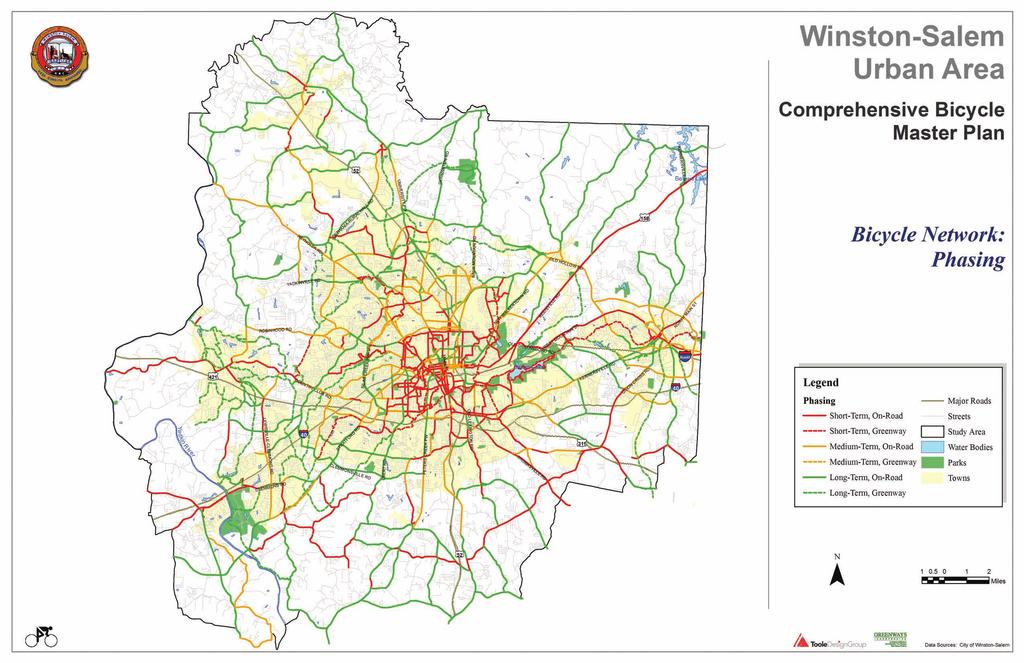
3 5) Start the process of education and awareness building by holding a public event to announce the adoption of the bicycle plan, system of signed bicycle routes, and some of the upcoming projects. 6) Begin working on the Top Priority Activities listed in subsections and (See Top-Priority Roadway Improvement map and Critical Intersection Improvements map) 7) Ensure that bicycle planning is integrated with other transportation planning efforts in the community as well as long-range and current land use planning, economic development planning, and environmental planning. 4.5 Physical Project Priorities The entire Winston-Salem Urban Area Bicycle Route Network is described in Chapter 3. However, the system will likely be developed incrementally. Development will occur piece by piece, in a coordinated effort between the City of Winston Salem, surrounding communities, and other local and state government bodies. This section describes how the recommended facilities in the Bicycle Network are prioritized. Higher priorities have been assigned to projects that are in areas with higher concentrations of population and/or trip attractors. Projects that can be integrated with other repaving or reconstruction improvements that are scheduled in the near future have also been given a high priority. Lower-priority projects are in areas with less population, areas where the trip attractors will likely serve fewer cyclists, and roadways that are not scheduled for regular transportation improvements. These projects may also be in areas where it is difficult to add shoulders or other bike facilities due to right-ofway constraints The Bicycle Network Phasing Map (following page) reflects prioritization by showing three categories of recommended facilities: short-term, medium-term, and long-term. A supplement to the map (Table 3), shows the total miles of recommended facilities for each of the three phases. Table 3. Winston-Salem Urban Area Bicycle Network Phasing Short Term Medium Term Long Term Facility Type Miles 1 Miles 1 Miles 1 Roads that could be signed as bicycle routes Paved shoulder Bicycle lane Shared-use path/greenway Other on-road bicycle accommodation Other on-road bicycle facility, but sidepath may be used in the short-term Unknown facility Total Centerline miles (facilities on both sides of the road are not counted separately). 2 These figures include bike routes being considered for the public bicycle map, which total miles. Note that some roadway segments recommended for bicycle routes are also included in the other categories. 3 Other on-road bicycle accommodations include edgelines and shared pavement markings. 4 The long-term goal for roads in this category is to provide on-road facilities for bicyclists. However, a sidepath adjacent to the roadway can be acceptable in the short-term wihen a roadway has high-speed, high-volume traffic and few intersecting roadways and driveways and there is no other option for widening the roadway. Sidepath bikeways in locations with frequent driveways are not a good solution due to conflicts with turning vehicles. If used, these facilities should not be signed as bike routes. NOTE: The GIS database lists this category as "Sidepath" or "Wide Sidewalks". 4-3
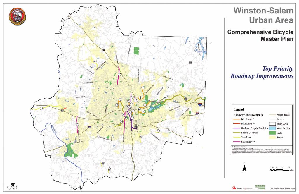
4 In general, short-term projects should be completed within the next five years, medium-term should be completed within 10 years, and long-term should be completed within 20 years. A prioritized list of all the projects is provided in Appendix F Top Priority Projects In addition to the short-term, medium-term, and longterm project phasing, the consultant team has created a list of top-priority action items that should receive immediate attention. These are specific improvements and changes that will facilitate an immediate increase in safety and a timely and orderly start to completing the short-term and medium-term project phases. These action items are listed in the following section, 4.5.2, and are shown on the three maps following that section: Top Priority Bike Route Signage Improvements, Top Priority Roadway Improvements, and Critical Intersections for Improvement. All signed routes shown on the Top Priority Bike Route Signage Improvement map should be addressed immediately. Completion of these actions will result in the creation of a new, modified system of signed bike routes based on the existing routes but with several changes for improving safety. For example, the signs on Summit Street between Fourth and Sixth Streets and the signs on Sixth Street between Summit Street and Trade Street would replace the existing bike routes on Fourth and Fifth Streets in the west part of Downtown Winston-Salem. Below, Table 4 shows the mileage of Top Priority Projects by facility type for all projects and for those within Winston-Salem City limits. On the following page are the top priority action items that include bicycle lanes, shoulders, sidewalks, and other facility types. Table 4. Top-Priority Projects All Top-Priority Projects 1 Top-Priority Projects within Winston-Salem City Limits 6 Facility Type Miles 2 Facility Type Miles 2 Signed bicycle route Signed bicycle route Bicycle lane 10.5 Bicycle lane 10.5 Paved shoulder 11.0 Paved shoulder 0.6 Shared-use path/greenway 14.8 Shared-use path/greenway 6.7 Other on-road bicycle accommodation Other on-road bicycle accommodation Other on-road bicycle facility, but shared-use Other on-road bicycle facility, but shareduse path may be used in the short-term path may be used in the short-term 5 Unknown facility 0.0 Unknown facility 0.0 Total Total All top-priority projects are also included in either the short-term, medium-term, or long-term categories in the table above. Most are short-term projects; some roadways have bike route signs recommended as top-priority projects and other facilities recommended in the medium- or long-term. 2 Centerline miles (facilities on both sides of the road are not counted separately). 3 These figures represent the bicycle routes that are being considered for the public bicycle map. Note that some roadway segments recommended for bicycle routes are also included in the other categories. 4 Other on-road bicycle accommodations include edgelines and shared pavement markings. 5 The long-term goal for roads in this category is to provide on-road facilities for bicyclists. However, a sidepath adjacent to the roadway can be acceptable in the short-term wihen a roadway has high-speed, high-volume traffic and few intersecting roadways and driveways and there is no other option for widening the roadway. Sidepath bikeways in locations with frequent driveways are not a good solution due to conflicts with turning vehicles. If used, these facilities should not be signed as bike routes. NOTE: The GIS database lists this category as "Sidepath" or "Wide Sidewalks". 6 Top-Priority Projects within the City limits are also counted as a part of All Top-Priority Projects. 4-4
5
6 4.5.2 Top Priority Action Items -The numbers next to the items match the numbers on the corresponding map. Bicycle Lanes 1 Salem Avenue: Bicycle lanes between First Street and Main Street 2 Reynolda Road: Bicycle lanes between Stratford Road and Buena Vista Road 3 Reynolds Park Road: Bicycle lanes between Martin Luther King, Jr. Drive and Reynolds Park 4 Old Greensboro Road: Bicycle lanes between Fifth Street and Reidsville Road 5 Stratford Road: Bicycle lanes between Runnymede Road and Reynolda Road 6 Bowen Boulevard: Bicycle lanes between Twenty-Fifth Street and Rosemary Drive 7 Carver School Road: Bicycle lanes between Lansing Drive and New Walkertown Road (except the blocks next to Carver High School where left-turn lanes are provided) 8 Cleveland Avenue: Bicycle lanes between Martin Luther King, Jr. Drive and Fourteenth Street and on-road facilities between Fourteenth Street and Twenty-Fifth Street 9 Liberty Street: Bicycle lanes between Martin Luther King Jr. Drive and Fifth Street 10 Main Street: Bicycle lanes between Fifth Street and Martin Luther King, Jr. Drive and on-road bicycle facilities between Waughtown Street and Clemmonsville Road On-Road Facilities 11 Cassell Street: On-road bicycle facilities between Main Street and Old Lexington Road 12 Patterson Avenue: On-road bicycle facilities between Fourteenth Street and Indiana Avenue 13 Trade Street: On-road bicycle facilities between Fourth Street and Martin Luther King, Jr. Drive; bicycle lanes between Martin Luther King, Jr. Drive and Northwest Boulevard 14 Broad Street: On-road bicycle facilities between Business Interstate 40 and Acadia Avenue 15 Sixth Street: On-road bicycle facilities between Trade Street and Main Street Shoulders 16 Shallowford Road: Shoulders between Williams Road and the Yadkin River (includes bike lanes b/w Williams and Lewisville-Vienna) 17 Old Lexington Road: Shoulders between Hillhaven Drive and Barnes Road 18 Union Cross Road: Shoulders between Ridgewood Road and Sawmill Road 19 Frye Bridge Road: Shoulders between Friedburg Church Road and Sunset Road 20 NC 150: Shoulders between Sunset Road and Community Road 21 Bethania-Tobaccoville Road: Shoulders between Bowens Road and Turfwood Drive Shared-Use Paths (separated from roadways) 22 Piedmont Greenway: Shared-use path east of Salem Lake 23 Brushy Fork Creek Trail (Virginia K. Newell/Ann Massey Trail): Shared-use path between Old Greensboro Road and the Salem Lake Trail (near Reynolds Park Road) 24 Salem Creek Trail Extension: Shared-use path between Market Place Mall and London Lane 25 Peters Creek Greenway Trail: Shared-use path between Reynolda Road and Salem Creek Trail Extension (as an alternative to Peters Creek Parkway for through bicyclists) Sidepaths (adjacent to roadways)* 26 Peters Creek Parkway: Sidepaths on both sides between the interchange with Business Interstate 40 and Clemmonsville Road (as facilities for pedestrians and bicyclists who are accessing destinations on Peters Creek Parkway) 27 University Parkway: Sidepaths on both sides between Silas Creek Parkway and Hanes Mill Road 28 Lewisville-Clemmons Road: Sidepaths on both sides between Styers Ferry Road and Peace Haven Road * On road bicycle facilities should be provided in the longer-term, but sidepaths can be beneficial on high-speed, high-volume roads when there are few intersecting roads and driveways. 4-5

7 4.6 Methods for Developing Facilities This section describes types of transportation facility construction and maintenance projects that can be used to create new bicycle facilities. Note that roadway and transit construction and re-construction projects offer excellent opportunities to incorporate facility improvements for bicyclists. It is much more cost-effective to provide a bicycle facility when these road projects are implemented than to initiate the improvement as a retrofit. In order to take advantage of upcoming opportunities to incorporate bicycle facilities into routine transportation projects, the City of Winston- Salem should continue to track the Metropolitan Transportation Improvement Program (MTIP), repaving schedules, and other lists of projects. As the MTIP is updated in future years, bicycle improvements should be included in all programmed projects Restriping The simplest type of restriping project is the addition of bicycle lanes, edgelines, or shoulder stripes to streets without making any other changes to the roadway. In the Winston-Salem Urban Area, opportunities for this type of improvement are found on some neighborhood collector streets within the City of Winston-Salem that are 30-, 34-, 36-, and 40-feet wide from curb to curb and are not used for on-street parking. Examples include sections of Reynolds Park Road and Carver School Road. Bicycle lanes, edgelines and shoulder stripes can also be added by narrowing the existing travel lanes or removing one or more travel lanes. In some locations where the existing lanes are 12- or 13-feet wide, it may be possible to narrow them to 10 feet. This requires changing the configuration of the roadway during a resurfacing project. Potential locations for this treatment include parts of Linden Street, Indiana Avenue, Liberty Street, and Polo Road Removing parking Some neighborhood collector roadways are wide enough to stripe with bike lanes, but they are used by residents for on-street parking, especially in the evening (e.g., Broad Street near Acadia Ave.; Thurmond St.). In locations like this, removing parking is likely to create considerable controversy and is not recommended unless there is no other solution (unless the parking is never used). In the rare case that removing parking is being considered, the parking should not be removed unless there is a great deal of public support for the bike lanes on that particular roadway, and a full public involvement process with adjacent residents and businesses is undertaken prior to removing parking. If it is not practical to add a bike lane, edgelines and shared lane markings may be considered. On roads where the outside lane and parking area combined are more than 17-feet-wide, 10-foot-wide travel lanes can be striped with an edgeline, leaving the rest of the space on either side for parking. The stripe would help slow motor vehicles and provide extra comfort for bicyclists, especially during the daytime when fewer cars would be parked along the curb. On roads with outside lane and parking areas that are narrower than 17-feet-wide, shared lane markings can be provided every 100 to 200 meters on the right side of the motor vehicle travel lane to increase the visibility of the bike route Repaving Repaving projects provide a clean slate for revising pavement markings. When a road is repaved, the Hawthorne Road, repaved with space for cyclists. 4-6
8 roadway should be restriped to create narrower lanes and provide space for bike lanes and shoulders. In addition, if the space on the sides of the roadway has a relatively level grade and few obstructions, the total pavement width can be widened to include paved shoulders. There are many rural roadways in the Winston-Salem Urban Area where this type of improvement can be made Roadway Construction and Reconstruction Bicycles should be accommodated any time a new road is constructed or an existing road is reconstructed. In the long-term, all roadways should have on-road bicycle facilities. However, sidepaths can be an acceptable solution in the short-term when a road has few driveways and high-speed, high-volume traffic. Roads should be designed according to the revised Thoroughfare Plan cross-sections (see Chapter 5) Bridge Replacement All new or replacement bridges should accommodate bicycles with on-road facilities on both sides of the bridge. If the bridge is in a developed area or an area that may experience development in the future, it should also have wide sidewalks on both sides to accommodate all types of bicyclists and pedestrians. Federal law, as established in the Transportation Equity Act for the 21 st Century (TEA-21), makes the following statements with respect to bridges: In any case where a highway bridge deck is being replaced or rehabilitated with Federal financial participation, and bicyclists are permitted on facilities at or near each end of such bridge, and the safe accommodation of bicyclists can be provided at reasonable cost as part of such replacement or rehabilitation, then such bridge shall be so replaced or rehabilitated as to provide such safe accommodations. (23 U.S.C. Section 217) On urban and suburban bridge projects, bridge shoulders should be a minimum of 5.5-feet wide and sidewalks should be a minimum of 5.5-feet wide if traffic volumes are projected to be less than 15,000 vehicles per day. If traffic volumes are projected to be 15,000 or more vehicles per day, the shoulders should be at least 6.5-feet wide and sidewalks should be at least 7-feet wide. Bridge replacement projects on controlled access freeways where pedestrians and bicyclists are prohibited by law will generally not include facilities to accommodate bicyclists and pedestrians. In cases, however, where a bridge replacement project on a controlled access freeway impacts a noncontrolled access roadway (i.e., a new overpass over an arterial roadway), the project should include the necessary access for pedestrians and bicyclists on the non-limited access roadway (i.e., paved shoulders, sidewalks, and pedestrian/bicycle crossing improvements) Retrofit Roadways with New Bicycle Facilities There may be critical locations in the Bicycle Route Network that have bicycle safety issues or are essential links to destinations. In these locations, it may be justified to add new bicycle facilities before a roadway is scheduled to be repaved or reconstructed. For example, Old Walkertown Road is currently a Forsyth County Bike Route, but it carries heavy, fast traffic and does not have shoulders. Adding five-foot shoulders to this roadway as a retrofit project would raise its Bicycle LOS grade in the area of Ibraham Elementary School from D to B. In some places, it may be relatively easy to add extra pavement for shoulders, but others may require removing trees, moving landscaping or fences, or regrading ditches or hills. Retrofitting roadways with sidepaths creates similar challenges. Improvements in these locations are typically recommended in the longterm Signage and Wayfinding Projects Signage along specific routes or in an entire community can be updated to make it easier for people to find destinations. Bicycle route signs are one example of these wayfinding signs, and they 4-7
9 can be installed along routes independently of other signage projects or as a part of a more comprehensive wayfinding improvement project. 4.7 Bicycle Policies Creation of a successful Bicycle Network will involve more than facility improvements. The long-term success of the bicycle network will also depend on how the City builds facility maintenance and longterm facility planning into its existing maintenance and planning practices. The subsections below detail these critical policy areas Maintenance Regular maintenance of the communityʼs bicycle facilities will be essential to maintain the safety of the facilities and their overall usability. To facilitate the practice of regular maintenance, the City should integrate bicycle facility maintenance into the maintenance routines of the DOT and the Parks and Recreation Department. Types of maintenance required include: Repair of pavement Restriping of lanes/remarking of pavement Replacement or repair of route signs due to damage caused by vandalism or general wear Removal of debris from roadway shoulders, bike lanes, and shared-use paths (including trash and vegetation) Replacement and repair of bicycle parking and storage facilities Many of these maintenance projects are already regularly completed for the area s roadways. They now should be expanded to include the bicycle facilities as well. Off-road bicycle routes may require the attention of separate agencies. Using the Bicycle Advisory Committee, the existing Bicycle planning staff from the City s DOT, and the bulleted list above, the City should develop a standard bicycle maintenance schedule for incorporation into the activities of all the appropriate City agencies Context Sensitive Design Context Sensitive Design changes the thinking and design of transportation planning so that roadways accommodate communities rather than communities accommodating roadways. Many of the principles of Context Sensitive Design are reflected in the planning documents of the MPO, but it is still important that the community establish policy standards that reflect these principles. These policies should ensure that all roadway projects are designed to maximize the safety of the facility user and the safety of the surrounding community. The policies should also require that all transportation facility construction be completed in a manner that is consistent with the communityʼs economic, social, and environmental objectives. In the end, the benefits of embracing this type of approach to transportation planning are more efficient use of transportation construction dollars, better preservation of community resources, increased safety, and improved livability in the community. Continued adherence to the principles of Context Sensitive Design will require the full support of the locally elected officials as well as continued support through state-level transportation actions Future Bicycle Facility Development Elected leaders should allocate sufficient resources on an annual basis to regularly expand the bicycle network and maintain the facilities as they are completed. This will ensure that the bicycle facilities recommended in this document and requested by the residents of the community will come to fruition. There must be commitment to a phased time line of roadway modification and facility construction must be adopted and followed. Regarding bicycle facilities on county and state roads, it will be important to understand how NCDOT and 4-8
10
11 the counties are involved in the approval process for reconstruction, repaving, and restriping projects on different roads in the Winston-Salem Urban Area. In some cases, the recommended facilities in the bicycle plan will not match the cross-sections recommended by the Winston-Salem Urban Area Thoroughfare Plan. If NCDOT or one of the counties has the authority to deny a recommendation from the bicycle plan, it will be important to discuss controversial issues with them during the planning process. The issues could potentially include: Striping 10-foot-wide motor vehicle travel lanes to slow traffic and provide space for bicycle lanes Striping bicycle lanes instead of providing wide outside motor vehicle travel lanes Adding shoulders to roads, which will require regrading the shoulder/ditch area and relocating existing mailboxes Education, Encouragement, Enforcement The recommended facilities will serve Winston-Salem most successfully with the continued support for programs that focus on the three Eʼs of bicycle planning: Education, Encouragement, and Enforcement. Education: Schools should be used to teach children about bicycle safety. Motorists should be taught to expect and work with cyclists who are sharing their travel corridors. Families should be given tools to help them understand how cycling opportunities can improve their lives. Encouragement: Financial incentives and/or public praise can be provided to local businesses who support cycling through their actions. Awards can be created to celebrate advances in the communityʼs bicycle facilities, bicycle ridership, and overall bicycle friendliness. Enforcement: The rights of cyclists to share the road and observance of traffic rules among cyclists must be enforced. Good policies are meaningless if they are not enforced. Winston-Salem has several existing programs in place (section 2.3); building on those programs will enhance awareness of safety issues while promoting the use of the facilities. Programs to start immediately could include: Safe Routes to School (SRTS) programs aim to improve the health of kids and the community by making walking and bicycling to school safer, easier and more enjoyable. Winston- Salem could build on the experiences of other communities while taking advantage of state and federal funding. ( Bicycle Safety Education programs for children and adults could be conducted through police departments, local bike clubs, and other public organizations. Such programs could take place in physical education classes at elementary, middle, and high schools, and through free programs at community centers and parks. Cyclist Awareness Campaigns could be used to advertise the benefits of biking not only for recreation, but also for practical purposes such as getting to work, school, or shopping. Campaigns could also be aimed at drivers to educate them about the safe operation of their vehicles near cyclists. These campaigns could be done through radio, television, and newspaper announcements. General Promotion could take place through enhancement of the City of Winston-Salem s bicycle web page. It could advertise benefits of cycling, explain relevant rules, show bike route plans and recommendations, and provide information about the latest successful projects. Distribution of the Bike Map could also raise awareness of cycling as an option. Education is a critical element within the recommendations of this chapter. Efforts to educate both cyclists and motorists should be undertaken immediately for the facilities to reach their full potential. 4-9
12
13
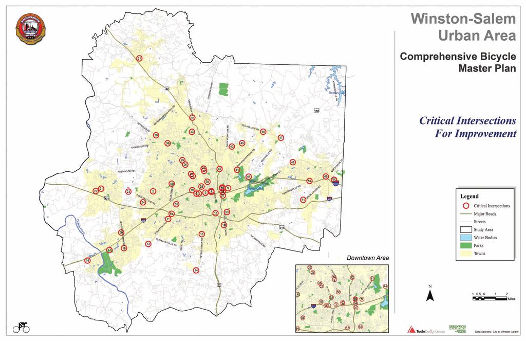
14 Critical Intersection Reference Table 28 Reynolda Rd & Northwest Blvd 1 Hawthorne Rd & First St 29 Reynolda Rd & Shattalon Dr 2 Cloverdale Ave & Business I Reynolda Rd & Bethabara Park Blvd 3 Second St & First St 31 Main St King & Jefferson Church Rd 4 Yorkshire Rd & Silas Creek Pkwy 32 University Pkwy & Hanes Mill Rd 5 Hearthside & Mtn View & Peace Haven Rd 33 University Pkwy & Oak Summit Rd 6 25th Street & University Pkwy 34 University Pkwy & Coliseum Dr 7 Strollway & 2nd St 35 Reynolda Rd & Coliseum Dr 8 Strollway & 1st St 36 University Pkwy & Northwest Blvd 9 Old Greensboro Rd & 3rd St & 5th St 37 Stadium Dr & MLK Jr Dr 10 Stratford & Country Club & Miller 38 MLK Jr Dr & Business I Burke Mill Rd & Atwood Rd & Stratford Rd 39 4th St & MLK Jr Dr 12 Fraternity Church Rd & Stratford Rd 40 5th St & MLK Jr Dr 13 Clemmonsville Rd & Peters Creek Pkwy 41 Carver School Rd & New Walkertown Rd 14 Salisbury Rd & Peters Creek Pkwy 42 Indiana Ave & Liberty St 15 Main St & Silas Creek Pkwy 43 Carver School Rd & Old Walkertown Rd 16 Cassell & Old Lexington & Clemmonsville 44 Old Greensboro Rd & Reidsville Rd 17 Harper Rd & Clemmons Rd 45 Oak Ridge & Dippen & Old Walkertown 18 Clemmons Rd & Lewisville-Clemmons Rd 46 Harley & Salem & Old Walkertown & NC US 158 & NC NC 66 & Reidsville Rd 20 Peace Haven Rd & Lewisville-Clemmons Rd 48 NC 66 & West Mountain St 21 Shallowford Rd & Lewisville-Clemmons Rd 49 East Mountain St & NC 66/NC Williams Rd & Shallowford Rd 50 East Mountain St & Old Greensboro Rd 23 Shallowford & Styers Ferry & Country Clu 51 Union Cross Rd & Sedge Garden Rd 24 Eastwin Dr & Heatherton & Jonestown R 52 Kernersville Rd & Business I Silas Creek Pkwy & Reynolda Rd 53 MLK Jr Dr & Waughtown & Thomasville 26 Wake Forest Rd & Reynolda Rd 54 Stratford Rd & I Stratford Rd & Reynolda Rd 55 Stratford Rd & Silas Creek Pkwy
chapter three new bike network
 chapter three new bike network 3.1 Overview Based on an examination of the existing conditions (Chapter 2) and an understanding of the communityʼs vision and goals for improved cycling opportunities (Chapter
STREET AND HIGHWAY PLAN
 STREET AND HIGHWAY PLAN Introduction The street and highway system in the Winston-Salem Urban Area consists of thousands of miles of traffic carrying facilities, ranging from short local residential streets
RESOLUTION NO ?? A RESOLUTION OF THE CITY OF NEPTUNE BEACH ADOPTING A COMPLETE STREETS POLICY
 RESOLUTION NO. 2018-?? A RESOLUTION OF THE CITY OF NEPTUNE BEACH ADOPTING A COMPLETE STREETS POLICY WHEREAS, safe, convenient, and accessible transportation for all users is a priority of the City of Neptune
Corpus Christi Metropolitan Transportation Plan Fiscal Year Introduction:
 Introduction: The Safe, Accountable, Flexible, Efficient Transportation Equity Act: A Legacy for Users (SAFETEA-LU) has continued the efforts started through the Intermodal Surface Transportation Efficiency
ACTIVE TRANSPORTATION
 ACTIVE TRANSPORTATION Mobility 2040 Supported Goals Improve the availability of transportation options for people and goods. Support travel efficiency measures and system enhancements targeted at congestion
Living Streets Policy
 Living Streets Policy Introduction Living streets balance the needs of motorists, bicyclists, pedestrians and transit riders in ways that promote safety and convenience, enhance community identity, create
MASTER BICYCLE AND PEDESTRIAN PLAN
 VILLAGE OF NORTHBROOK MASTER BICYCLE AND PEDESTRIAN PLAN DRAFT PLAN OPEN HOUSE May 2, 2018 AGENDA 1. Community Engagement 2. Vision and Goals 3. General Structure of Plan 4. Recommendations Overview 5.
CONNECTING PEOPLE TO PLACES
 CONNECTING PEOPLE TO PLACES 82 EAST BENCH MASTER PLAN 07 Introduction The East Bench transportation system is a collection of slow moving, treelined residential streets and major arteries that are the
Recommendations. Implementation
 Recommendations This report documents the development of the Winston-Salem MPO CTP as shown in Figure 2-1. This chapter presents recommendations for each mode of transportation in the MPO. Implementation
Chapter 2. Bellingham Bicycle Master Plan Chapter 2: Policies and Actions
 Chapter 2 Bellingham Bicycle Master Plan Chapter 2: Policies and Actions Chapter 2: Policies and Actions The Bicycle Master Plan provides a road map for making bicycling in Bellingham a viable transportation
Goodlettsville Bicycle and Pedestrian Plan Executive Summary
 Goodlettsville Bicycle and Pedestrian Plan July 2010 In Cooperation with the Nashville Area Metropolitan Planning Executive Organization Summary Introduction Progressive and forward thinking communities
4 Goals, Objectives & Actions
 Chapter4 4 This chapter presents goals, objectives, and recommended actions to support the vision of making Overland Park a safer and easier place to ride a bicycle. 35 4.1 Recommendations Structure The
Madison Urban Area and Dane County. Bicycle Transportation Plan Summary. September Introduction. Bicycle Plan Scope and Planning Process
 Bicycle Transportation Plan Summary Madison Urban Area and Dane County Introduction September 2000 Bicycling is an important mode of transportation in the Madison urban area and countywide that is available
Prince George s County plans, policies, and projects
 Prince George s County plans, policies, and projects Over 250 projects for trails, bikeways, designated bike lanes and sidewalk construction Trail projects that improve access to Metro Sidewalk and trail
Bicycle Master Plan Goals, Strategies, and Policies
 Bicycle Master Plan Goals, Strategies, and Policies Mobilizing 5 This chapter outlines the overarching goals, action statements, and action items Long Beach will take in order to achieve its vision of
Planning Guidance in the 2012 AASHTO Bike Guide
 Planning Guidance in the 2012 AASHTO Bike Guide Presentation by: RJ Eldridge Peter Lagerwey August 22, 2012 WEBINAR 2: PLANNING GUIDANCE IN THE 2012 AASHTO BIKE GUIDE Today s Webinar Significant Updates
NM-POLICY 1: Improve service levels, participation, and options for non-motorized transportation modes throughout the County.
 Transportation PRINCE WILLIAM COUNTY 2008 COMPREHENSIVE PLAN NON-MOTORIZED PLAN CONTENTS Goals, Policies, and Action Strategies Table 4 (Bike Facility Classifications and Descriptions) Table 5 (Bike Facility
City of Waterloo Complete Streets Policy
 City of Waterloo Complete Streets Policy Chris Hodgson P. Eng City of Waterloo Complete Streets Forum 2011 April 28-29 Toronto Waterloo context: Current population Major employers Universities and student
Complete Streets for Louisiana
 Complete Streets for Louisiana Louisiana Transportation Conference 2011 Ellen W. Soll, AICP Planner Burk-Kleinpeter, Inc esoll@bkiusa.com 504.486.5901 x143 What is a Complete Street? What are Complete
REGIONAL BICYCLE AND PEDESTRIAN DESIGN GUIDELINES
 REGIONAL BICYCLE AND PEDESTRIAN DESIGN GUIDELINES November 16, 2011 Deb Humphreys North Central Texas Council of Governments Bicycle and Pedestrian Advisory Committee Snapshot of the Guide 1. Introduction
Bikeway action plan. Bicycle Friendly Community Workshop March 5, 2007 Rochester, MN
 Bikeway action plan Summary The was held on March 5, 2007 at the Rochester Mayo Civic Center. The workshop was hosted by Rochester-Olmsted County Planning Department in collaboration with the League of
City of Novi Non-Motorized Master Plan 2011 Executive Summary
 City of Novi Non-Motorized Master Plan 2011 Executive Summary Prepared by: February 28, 2011 Why Plan? Encouraging healthy, active lifestyles through pathway and sidewalk connectivity has been a focus
CITY OF BLOOMINGTON COMPLETE STREETS POLICY
 CITY OF BLOOMINGTON COMPLETE STREETS POLICY POLICY OBJECTIVE: The City of Bloomington will enhance safety, mobility, accessibility and convenience for transportation network users of all ages and abilities,
U-4918A Research Park Boulevard Transportation Improvements from Rams Drive to Third Street 1.0
 Winston-Salem Urban Area Metropolitan Planning Organization 2035 Fiscally Constrained Long Range Transportation Plan 2015 Street and Highway Project List Mileage Existing Proposed Regional Federal STIP
5. Bicycle & Pedestrian Element. 5.1 Bicycle Transportation. Executive Summary/Key Points
 5. Bicycle & Pedestrian Element Executive Summary/Key Points Providing bicycle and pedestrian transportation options is one of the key elements in building a healthy, livable community. To encourage greater
Cyclists and Bikeways: What s your match? A guide to bikeway options for a variety of cyclists
 Cyclists and Bikeways: What s your match? guide to bikeway options for a variety of cyclists The workshop and this resource were made possible by funding from the Province of Ontario via the Ministry of
BIKE PLAN CONTENTS GATEWAY
 CONTENTS Acknowledgments...vii Great Rivers Greenway District Board of Directors... vii Great Rivers Greenway District Staff... vii Project Consultants... vii Committees... viii Citizens Advisory Committee
General Design Factors
 Chapter 3: 3-1.0 Introduction General Design Factors Mn/DOT s goals include encouraging and accommodating safe bicycling. From a design perspective, these goals are achieved by first having an understanding
West Dimond Blvd Upgrade Jodhpur Street to Sand Lake Road
 West Dimond Blvd Jodhpur St to Sand Lake CSS Transportation Project Summary Municipality of Anchorage Project # 05 005 Project Manager: John Smith, P.E. (MOA PM&E) Project Administrator: Julie Makela,
APPENDIX A: Complete Streets Checklist DRAFT NOVEMBER 2016
 APPENDIX A: Complete Streets Checklist DRAFT NOVEMBER 2016 Complete Streets Checklist MetroPlan Orlando s Complete Streets Checklist is an internal planning tool for staff to further implementation of
Chapter 5 Future Transportation
 Chapter 5 Future Transportation The Future Land Use Plan identifies the desired land use designations. The land uses desired for Crozet depend, in large part, on the success of the transportation system,
What Is a Complete Street?
 Session 5 Charleen Zimmer, AICP, Zan Associates May 5-7, 2010 What Is a Complete Street? May 2010 5-1 Not a Complete Street More of a Complete Street May 2010 5-2 Benefits of Complete Streets Safety for
Hennepin County Bicycle and Pedestrian Planning
 Hennepin County Bicycle and Pedestrian Planning 1 Value of bicycle and sidewalk systems Safety Livability Mobility Health Personal Finances Economic Sustainability Clean Air Recreation Parking and congestion
Physical Implications of Complete Streets Policies
 Presentation Overview Physical Implications of Complete Norm Cox, ASLA, LLA Landscape Architect Ann Arbor, Michigan, 10:45 to Noon What Are Complete Streets? What Matters to Bicyclists and Pedestrians
Who is Toole Design Group?
 2018 AASHTO Bike Guide Status Update NCHRP 15 60 Amalia Leighton Cody, PE, AICP & Kenneth Loen, PE Washington APWA October 4, 2018 Who is Toole Design Group? TDG is a full service engineering, planning
Evolving Roadway Design Policies for Walking and Bicycling
 Evolving Roadway Design Policies for Walking and Bicycling The 2016 Michigan Transportation Planning Conference Kalamazoo, MI July 13, 2016 Title 23 of the Code of Federal Regulations Title 23 was originally
TOWN OF WILLIAMSTON, SC BICYCLE AND PEDESTRIAN MASTER PLAN TOWN OF WILLIAMSTON, SC BICYCLE AND PEDESTRIAN MASTER PLAN
 TOWN OF WILLIAMSTON, SC BICYCLE AND PEDESTRIAN MASTER PLAN Americans Want Choices 55% of Americans would rather drive less & walk more. Transit use is growing faster than population or highway travel.
Non-Motorized Transportation 7-1
 Non-Motorized Transportation 7-1 Transportation facilities no longer mean just accommodating a vehicle powered by a combustion engine. Pedestrian and non-motorized facilities are important modes of travel
Chapter 7. Transportation. Transportation Road Network Plan Transit Cyclists Pedestrians Multi-Use and Equestrian Trails
 Chapter 7 Transportation Transportation Road Network Plan Transit Cyclists Pedestrians Multi-Use and Equestrian Trails 7.1 TRANSPORTATION BACKGROUND The District of Maple Ridge faces a number of unique
CHAPTER 3: Vision Statement and Goals
 Davidson Walks & Rolls: Active Transportation Master Plan CHAPTER 3 Contents: Overview Vision Statement Measurable Goals Public Outreach CHAPTER 3: Vision Statement and Goals Overview The vision statement
Agenda. Overview PRINCE GEORGE S PLAZA METRO AREA PEDESTRIAN PLAN
 PRINCE GEORGE S PLAZA METRO AREA PEDESTRIAN PLAN May 28, 2008 Agenda Welcome and introductions Project overview and issue identification Planning context and strengths Design challenges and initial recommendations
Bicycle and Pedestrian Chapter TPP Update Overview. TAB September 20, 2017
 Bicycle and Pedestrian Chapter TPP Update Overview TAB September 20, 2017 Bicycling & Walking in the Twin Cities Where are we now? The Bike-Pedestrian system Current trends New developments Where are we
APPROVE A RESOLUTION ADOPTING A COMPLETE STREETS POLICY
 STAFF REPORT MEETING DATE: September 13, 2016 TO: FROM: City Council Bob Brown, Community Development Director Russ Thompson, Public Works Director Patrick Filipelli, Management Analyst 922 Machin Avenue
Appendix 3 Roadway and Bike/Ped Design Standards
 Appendix 3 Roadway and Bike/Ped Design Standards OTO Transportation Plan 2040 4/20/2017 Page A3-1 Adopted Standards The adopted OTO Design Standards and Major Thoroughfare Plan are contained herein.
Overview. Illinois Bike Summit IDOT Complete Streets Policy Presentation. What is a Complete Street? And why build them? And why build them?
 Overview Illinois Bike Summit IDOT Complete Streets Policy Presentation Aren Kriks, P.E. District One Bicycle Coordinator and Bureau of Programming Project Engineer History of Complete Streets IDOT Policy
Safe Streets. City of Lake Forest Park. March 21, 2017
 Safe Streets City of Lake Forest Park March 21, 2017 1 01 WELCOME 2 Agenda WELCOME WHAT IS THIS PROJECT? CONTEXT DRAFT CITYWIDE PROJECTS EXERCISE INTRODUCTION 3 02 WHAT IS THIS PROJECT? 4 WHAT IS THIS
5 CIRCULATION AND STREET DESIGN
 5 CIRCULATION AND STREET DESIGN This chapter describes circulation and streetscape improvements proposed for the Northwest Chico Specific Plan Area. It includes detailed design specifications for existing
Proposed. City of Grand Junction Complete Streets Policy. Exhibit 10
 Proposed City of Grand Junction Complete Streets Policy Exhibit 10 1 City of Grand Junction Complete Streets Policy Vision: The Complete Streets Vision is to develop a safe, efficient, and reliable travel
Double the amount of bicycle ridership while at the same time reducing the number of bicycle crashes by one-third.
 CHAPTER 6 Recommended Policies and Action Items To achieve the goals stated in Chapter 1 and guide implementation of the Bicycle Plan, policies and action items have been identified. They are presented
WINSTON-SALEM URBAN AREA MPO BICYCLE & PEDESTRIAN PROGRAM. Greg Errett City of Winston-Salem DOT September 14, 2011
 WINSTON-SALEM URBAN AREA MPO BICYCLE & PEDESTRIAN PROGRAM Greg Errett City of Winston-Salem DOT September 14, 2011 Presentation Outline History MPO Expansion/Changes Current Plans State of Active Transportation
Complete Streets Policy DAVID CRONIN, P.E., CITY ENGINEER
 Complete Streets Policy DAVID CRONIN, P.E., CITY ENGINEER Complete Streets City Commission adopted a Complete Streets policy in 2012 Complete Streets are road networks that are designed for all users:
EXECUTIVE SUMMARY. Vision
 Vision Walking and bicycling in Salt Lake City will be safe, convenient, comfortable, and viable transportation options that connect people to places, foster recreational and economic development opportunities,
Safe Routes to School Action Plan Aberdeen, Idaho
 Background Aberdeen, Idaho is a largely agricultural community of nearly 2,000 people and is located in the southeast portion of the state on the western edge of American Falls Reservoir. The community
GPATS Long-Range Transportation Plan. Complete Streets
 GPATS Long-Range Transportation Plan 5: BICYCLE AND PEDESTRIAN INTRODUCTION Complete Streets As the GPATS region grows, the role the active transportation infrastructure plays in the regional transportation
DRAFT MOVING FORWARD RHODE ISLAND BICYCLE MOBILITY PLAN 2018 PREPARED FOR PREPARED BY IN ASSOCIATION WITH
 RHODE ISLAND MOVING FORWARD BICYCLE MOBILITY PLAN 2018 PREPARED FOR PREPARED BY IN ASSOCIATION WITH T AF CHAPTER 1 D R INTRODUCTION CHAPTER 3 ARTICULATES VISION Bicycling is safe, fun and practical in
CHAPTER 1 INTRODUCTION
 CHAPTER 1 INTRODUCTION Chapter Table of Contents THE 2017 HOUSTON BIKE PLAN 1-1 HOUSTON BIKEWAYS PROGRAM 1-2 HISTORY OF BICYCLE PLANNING IN HOUSTON 1-3 BICYCLE LEVEL OF COMFORT 1-3 EXISTING PLANS, PROGRAMS
Gordon Proctor Director Policy on Accommodating Bicycle and Pedestrian Travel on ODOT Owned or Maintained Facilities
 Approved: Policy: 20-004(P) Responsible Office: Planning Gordon Proctor Director Policy on Accommodating Bicycle and Pedestrian Travel on ODOT Owned or Maintained Facilities I. POLICY STATEMENT: This policy
INDOT Complete Streets Guideline & Policy
 INDOT Complete Streets Guideline & Policy INTRODUCTION The Complete Streets guidelines build upon multiple efforts and promote a multimodal transportation system that is integrated and sustains land use
Active Transportation Facility Glossary
 Active Transportation Facility Glossary This document defines different active transportation facilities and suggests appropriate corridor types. Click on a facility type to jump to its definition. Bike
This page intentionally left blank.
 This page intentionally left blank. COMMUNITY Glenpool Community Overview Glenpool Glenpool is a city of nearly 12,000 residents located in Tulsa County southwest of Tulsa and Jenks. The city is growing
Implementation challenge 2: Is there room for Complete Streets? Does street classification enable Complete Streets?
 Implementation challenge 2: Is there room for Complete Streets? Does street classification enable Complete Streets? 1 Do we have to widen roads to fit everything? 2 There s room; it needs to be recaptured
2. Vision & Goals. Vision. Santa Rosa is a community where walking and bicycling are comfortable and convenient for people of all ages and abilities.
 2. Vision & Goals Overview The goals of the Santa Rosa Bicycle and Pedestrian Master Plan Update reflect the priorities expressed by the community throughout the public outreach phase of this Plan Update.
chapter five facility standards
 chapter five facility standards 5.1 General Guidelines This section of the report provides design guidelines for the development of bicycle and pedestrian facilities. They are based on the best practices
Linking Transportation and Health in Nashville & Middle Tennessee
 Linking Transportation and Health in Nashville & Middle Tennessee Fit Nation New Orleans CPPW Mentoring Grant Built Environment Program May 14, 2011 Local Transportation Planning Framework Federal U.S.
Complete Streets. Designing Streets for Everyone. Sarnia
 Complete Streets Designing Streets for Everyone Sarnia Complete Streets ~ Sarnia ~ 2018 Introduction Our City is made up of a network of streets that we use to go for a walk, cycle to work, drive to the
East Burke Transportation, Safety and Capacity Improvements
 East Burke Transportation, Safety and Capacity Improvements The purpose of this project is to increase mobility and improve safety for pedestrians, cyclists, and motor vehicles along VT Route 114 in the
CITY OF ELKO BICYCLE AND PATHWAY PLAN
 CITY OF ELKO BICYCLE AND PATHWAY PLAN INTRODUCTION: The City of Elko is intended to provide the basic framework for the development of a functional bicycle and pathway system for the community with connections
PRESS RELEASE San Joaquin Council of Governments
 PRESS RELEASE San Joaquin Council of Governments For Immediate Release February 23, 2018 Contact: Nicole Gorham, 235-0582 gorham@sjcog.org SJCOG Board Awards $19.63 Million in Measure K Bicycle, Pedestrian,
TOWN OF PORTLAND, CONNECTICUT COMPLETE STREETS POLICY
 TOWN OF PORTLAND, CONNECTICUT COMPLETE STREETS POLICY I. VISION, GOALS & PRINCIPLES VISION To improve the streets of Portland making them safer and more accessible for all users including pedestrians,
This page intentionally left blank.
 This page intentionally left blank. COMMUNITY Coweta Community Overview Coweta Coweta, a residential community located in Wagoner County, is a suburb of Tulsa situated southeast of the metropolitan area
Chapter VISION, MISSION, AND GOALS AND OBJECTIVES. Vision. Mission. Goals and Objectives CONNECTING COMMUNITIES ACROSS THE ST.
 VISION, MISSION, AND GOALS AND OBJECTIVES Chapter 3 The Plan s vision, mission, and goals and objectives were developed through a series of interactive exercises with the Citizens Advisory Committee (CAC)
Cycle Track Design Best Practices Cycle Track Sections
 Design Best Practices Sections It is along street segments where the separation and protection methods of cycle tracks offer more comfort than conventional bicycle lanes, and are more attractive to a wide
Omaha s Complete Streets Policy
 Omaha s Complete Streets Policy (Adopted August 2015) VISION To create great places and enhance our quality of life, the City of Omaha will provide safe, accessible streets for all users. Complete Streets
DRAFT - CITY OF MEDFORD TRANSPORTATION SYSTEM PLAN Roadway Cross-Sections
 Roadway Cross-Sections Medford s roadway cross-section standards apply to new and reconstructed roads. The crosssections take into consideration roadway function and operational characteristics, including
ARLINGTON COUNTY, VIRGINIA
 ARLINGTON COUNTY, VIRGINIA County Board Agenda Item Meeting of October 15, 2016 DATE: October 7, 2016 SUBJECT: Adoption of amendments to the Master Transportation Plan (MTP) to create a new Pedestrian
PEDESTRIAN ACTION PLAN
 ATTACHMENT 2 CITY OF SANTA MONICA PEDESTRIAN ACTION PLAN CITY OF SANTA MONICA PEDESTRIAN ACTION PLAN This page intentionally left blank EXECUTIVE SUMMARY CHAPTER 1 EXECUTIVE SUMMARY Setting the Stage
Basalt Creek Transportation Refinement Plan Recommendations
 Basalt Creek Transportation Refinement Plan Recommendations Introduction The Basalt Creek transportation planning effort analyzed future transportation conditions and evaluated alternative strategies for
Exhibit 1 PLANNING COMMISSION AGENDA ITEM
 Exhibit 1 PLANNING COMMISSION AGENDA ITEM Project Name: Grand Junction Circulation Plan Grand Junction Complete Streets Policy Applicant: City of Grand Junction Representative: David Thornton Address:
Purpose. Process. Recommendations
 Summary Document Purpose The was developed to increase safety, mobility, and recognition of cycling in the High Country region (Alleghany, Ashe, Avery, Mitchell, Watauga, Wilkes, and Yancey Counties).
Bicycle Facilities Planning
 Bicycle Facilities Planning Overview Types of Cyclists Purpose for Riding Types of Facilities Bike Lanes Bicycle Boulevards Cycle Tracks Intersections Signals Signing and Marking Discussion Types of Bicyclists
City of Gainesville Transportation/Roadway Needs PROJECT SUMMARY
 A1 Roadway Resurfacing $23,846,000 TYPE: Preservation of existing system Roadway resurfacing A2 Signal Replacement $6,000,000 TYPE: Preservation of existing system Replace traffic signals. B1 W 6th St
CHAPTER 7.0 IMPLEMENTATION
 CHAPTER 7.0 IMPLEMENTATION Achieving the vision of the Better Streets Plan will rely on the ability to effectively fund, build and maintain improvements, and to sustain improvements over time. CHAPTER
Driving directions during the closure of Business 40 for the Downtown Health Plaza in Innovation Quarter
 Driving directions during the closure of Business 40 for the Downtown Health Plaza in Innovation Quarter BUSINESS 40 IMPROVEMENT PROJECT AUGUST 31, 2018 DRIVING TO THE DOWNTOWN HEALTH PLAZA DURING BUSINESS
SANTA CLARA COUNTYWIDE BICYCLE PLAN August 2008
 SANTA CLARA COUNTYWIDE BICYCLE PLAN August 2008 To assist VTA and Member Agencies in the planning, development and programming of bicycle improvements in Santa Clara County. Vision Statement To establish,
NJDOT Complete Streets Checklist
 Background The New Jersey Department of Transportation s Complete Streets Policy promotes a comprehensive, integrated, connected multi-modal network by providing connections to bicycling and walking trip
On Road Bikeways Part 1: Bicycle Lane Design
 On Road Bikeways Part 1: Bicycle Lane Design Presentation by: Nick Jackson Bill Schultheiss, P.E. September 04, 2012 FOLLOW THE CONVERSATION ON TWITTER Toole Design Group is live tweeting this webinar
TABLE OF CONTENTS 7.0 THOROUGHFARE PLAN. Analysis of Future Conditions Thoroughfare Plan Proposed Cross-Sections.. 7.
 TABLE OF CONTENTS 7.0 THOROUGHFARE PLAN Analysis of Future Conditions.. 7.2 Thoroughfare Plan.. 7.3 Proposed Cross-Sections.. 7.4 Arterials Minor Arterials Collectors Local Streets Thoroughfare Plan Map
Solana Beach Comprehensive Active Transportation Strategy (CATS)
") Solana Beach Comprehensive Active Transportation Strategy (CATS) 3.0 Goals & Policies The Solana Beach CATS goals and objectives outlined below were largely drawn from the Solana Beach Circulation Element
Solana Beach Comprehensive Active Transportation Strategy (CATS) 3.0 Goals & Policies The Solana Beach CATS goals and objectives outlined below were largely drawn from the Solana Beach Circulation Element
2014 Bellingham Bicycle Master Plan
 2014 Bellingham Bicycle Master Plan Acknowledgements The City of Bellingham is honored by the commitment of the numerous community members and bicycling enthusiasts who participated in the development
2.0 Existing Conditions
 20 2.0 Existing Conditions 2.1 Land Use, Future Growth Patterns, Physical Barriers Geographic Overview Sutter County s land use pattern is characterized by extensive agricultural areas, significant natural
Complete Streets Training. Georgia Municipal Association June 27, 2016
 Complete Streets Training Georgia Municipal Association June 27, 2016 Overview What are CS? GDOT s Policy Case Study 2 What are Complete Streets? According to the National Complete Streets Coalition, complete
Circulation in Elk Grove includes: Motor vehicles, including cars and trucks
 Circulation, as it is used in this General Plan, refers to the many ways people and goods move from place to place in Elk Grove and the region. Circulation in Elk Grove includes: Motor vehicles, including
Transportation Master Plan Advisory Task Force
 Transportation Master Plan Advisory Task Force Network Alternatives & Phasing Strategy February 2016 BACKGROUND Table of Contents BACKGROUND Purpose & Introduction 2 Linking the TMP to Key Council Approved
Clackamas County Comprehensive Plan
 ROADWAYS The County s road system permits the movement of goods and people between communities and regions, using any of a variety of modes of travel. Roads provide access to virtually all property. They
2014 Wisconsin Tribal Transportation Conference. Matt Halada Transportation Planner NE Region
 2014 Wisconsin Tribal Transportation Conference Matt Halada Transportation Planner NE Region Implementing Wisconsin s Pedestrian and Bicycle Accommodations Law (Complete Streets) Tools and methods for
Duwamish Way-finding and CTR Report
 V. North Tukwila When the North Tukwila Manufacturing and Industrial Center was designated in 1992 as part of the region s land use and transportation plan, the plan called for the area to set a light-rail
CITY MANUALS AND STANDARDS REVIEW
 GEORGETOWN SIDEWALK MASTER PLAN CITY MANUALS AND STANDARDS REVIEW RESOURCES AND STANDARDS As part of the Master Plan process, a review and evaluation of current City documents and policies relevant to
5. RUNNINGWAY GUIDELINES
 5. RUNNINGWAY GUIDELINES These guidelines should be considered collectively when making runningway decisions. A runningway is the linear component of the transit system that forms the right-of-way reserved
Chapter 5. Complete Streets and Walkable Communities.
 Chapter 5. Complete Streets and Walkable Communities. 5.1 Description of Complete Streets. Cities throughout the world, and specifically the United States, are coming to embrace a new transportation and
Toward Zero Deaths. Regional SHSP Road Show Meeting. Virginia Strategic Highway Safety Plan. presented by
 Toward Zero Deaths Regional SHSP Road Show Meeting presented by Virginia Strategic Highway Safety Plan December 1, 2016 1 Welcome & Introductions Purpose of the Meeting Objectives & Key Outcomes Agenda»