TABLE OF CONTENTS LIST OF PHOTOGRAPHS EXHIBIT 1 LOCATION MAP... 2 LIST OF TABLES
|
|
|
- Cornelius Barton
- 5 years ago
- Views:
Transcription

1
2 TABLE OF CONTENTS I. INTRODUCTION... 1 II. PURPOSE AND OBJECTIVES... 3 III. STUDY METHODOLOGY... 4 IV. EXISTING CONDITIONS... 5 V. SHARED USE PATH CONCEPT PLAN FEASIBILITY ANALYSIS... 9 VI. FINANCIAL FEASIBILITY VII. DATA COLLECTION REFERENCES LIST OF PHOTOGRAPHS EXHIBIT 1 LOCATION MAP... 2 LIST OF TABLES TABLE 1 APPARENT RIGHT-OF-WAY... 7 TABLE 2 ENGINEER S OPINION OF PROBABLE COSTS (CONCRETE) TABLE 3 ENGINEER S OPINION OF PROBABLE COSTS (ASPHALT) APPENDICES APPENDIX A Photographs APPENDIX B Shared Use Path Concept Plans APPENDIX C National Wetlands Inventory Maps APPENDIX D Soils Maps APPENDIX E Flood Insurance Rate Maps APPENDIX F FDOT Inflation Rates i

3 Introduction Introduction
4 I. INTRODUCTION The City of Deltona has submitted an application to the River to Sea Transportation Planning Organization (R2CTPO) for the review of a feasibility study for a new 6.1-mile shared use path. The intent is to provide a 10-ft ft. wide path where possible. Although not preferred, it may be necessary to further reduce the width to an 8-ft. sidewalk in order to minimize and/or avoid conflicts with utilities and drainage, as well as avoid right-of-way acquisition. The shared use path will follow along the east side of Providence Boulevard through Deltona from the East Central Florida Regional Trail to just south of Beaver Drive. This project will connect four major commercial nodes as well as connect over twentyfour public facilities. It will also provide connectivity to the East Central Florida Regional Trail and the Lakeshore Multi-use Path. See Exhibit 1, Project Location Map. The impetus for this project is based on the need to meet the City s mobility standards in Deltona s Comprehensive Plan, which are to expand connections to commercial, institutional, and recreational nodes for bicycle and pedestrian use. The shared use path will comply with the pedestrian and bicycle standards set forth in Deltona s Land Development Code and the 2010 ADA Standards for Accessible Design. Page 1


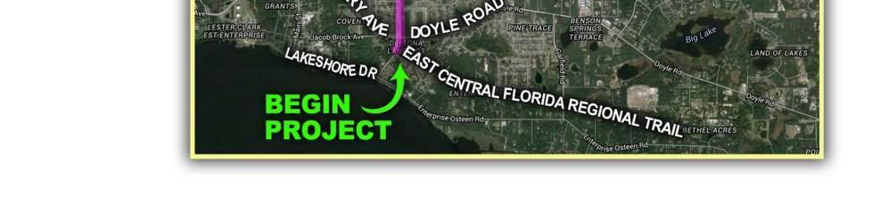
5 Exhibit 1 - Project Location Map Page 2
6 Purpose and Objectives Purpose and Objectives
7 II. PURPOSE AND OBJECTIVE The purpose of this project is to assess the feasibility of constructing a 10-ft - 12-ft. shared use path along Providence Boulevard from the East Central Regional Rail Trail to just south of Beaver Drive. The objective of the study is to determine the conceptual alignment of the shared use path along Providence Boulevard given the many constraints that exist within the potential shared use path alignments. Providing a continuous shared use path along Providence Boulevard will connect over twenty-four public facilities, as well as four commercial nodes for shopping and employment. More specifically, the shared use path will improve the safety for pedestrians and bicyclists using the library complex, Daytona State College, City Hall, a middle school and two elementary schools. This project will benefit not only those residents adjacent to the corridor, but also residents, businesses, and school students within the project area. This study required coordination with several agency representatives and stakeholders that the study team would like to thank for their continuing interest in this project and their assistance: Mr. Stephen Harris River to Sea Transportation Planning Organization Ms. Cheryl Atkins City of Deltona Mr. Scott McGrath City of Deltona Mr. Jerry Mayes City of Deltona Mr. Scott Martin, P.E. Volusia County Page 3

8 Study Methodology Study Methodology
9 III. STUDY METHODOLOGY The following tasks were completed so that a detailed feasibility report can be provided: 1. A project coordination meeting was held with R2CTPO s project manager, Volusia County and the City of Deltona staff for the purpose of scoping the project and obtaining relevant project information. 2. Data collection consisted of reviewing the City s Comprehensive Plan, Land Development Code, and Bicycle and Pedestrian Master Plan. Additionally, aerial photography was obtained as well as right-of-way and parcel lines from Volusia County s Geographic Information System (GIS). The team also reviewed Federal Emergency Management Agency (FEMA) Flood Insurance Rate Maps (FIRM), Map Nos C0620J, 12127C0630J, 12127C0640J, and 12127C0735J, United States Soil Conservation Service Soil Survey maps, and the National Wetlands Inventory maps to gain a better understanding of the project. Additionally, the Lakeshore Drive Shared Use Feasibility Study was reviewed. 3. Three site visits were conducted in the project corridor to assess current constraints. Photographs and aerial maps were used to document the items that would impact constructability such as power and light pole locations, guy wires, other utility features, fencing, drainage features, landscaping, mailboxes, bus stops, large trees, etc. The aerial photography and information collected from our site visits is the foundation for the conceptual design. No survey was performed. 4. Typical sections were developed and concept plans were created from the information collected from the previous tasks. The design criteria used to develop the concept plans are as follows: a Plans Preparation Manual, FDOT b. Manual on Uniform Traffic Control Devices, FHWA c FDOT Design Standards d Florida Green Book e ADA Standards for Accessible Design 5. An Engineer s Opinion of Probable Costs (EOPC) to construct the conceptual design was prepared. The EOPC unit prices were obtained from the FDOT s historical statewide average costs. 6. Preparation of the final report will occur after receipt of comments from the City, R2CTPO, FDOT and Volusia County. Page 4
10 Existing Conditions Existing Conditions
11 IV. EXISTING CONDITIONS Existing conditions were noted during our site visits. The site visits began at south of the East Central Regional Rail Trail and continued north for 6.1 miles to Beaver Drive. Photographs from the site visits are located in Appendix A. The existing speed limit is predominantly 35 MPH, however, from the East Central Regional Rail Trail Drive to DeBary Avenue, the posted speed limit is 30 MPH. There are two school zones within the corridor. The speed limit within these zones is reduced to 20 MPH for a short time period before and after school lets out. There is approximately 3.7 miles of existing sidewalk located on the east side of Providence Boulevard at the following locations: Lakeshore Drive to DeBary Avenue 5-ft. wide Alexander Avenue to the entrance to Deltona Lakes Elementary School varies 4-5-ft. wide Joyner Drive to Howland Boulevard varies 4-5-ft. wide The majority of the existing sidewalk along the east side of Providence Boulevard will be removed in order to make room for the proposed shared use path. See the Concept Plans for exact locations of removal. Please note, the majority of the sidewalk from the northerly Joyner Drive/Providence Boulevard intersection to Beaver Drive is in very poor condition. Much of it is severely cracked, due in large part to being exposed to vehicular traffic because it is located directly adjacent to the roadway paved shoulder. Driveways and Side Streets There are one hundred seventy-four residential driveways and twelve commercial driveways located on the east side of Providence Boulevard within the project limits. The residential driveways are all concrete and the majority of the commercial driveways are asphalt. There are sixty-two side street intersections within the project limits. Thirty-nine of these intersect the east side of the roadway. Of the sixty-two intersections, the following seven are signalized: DeBary Ave/Doyle Road East Normandy Boulevard Saxon Boulevard Tivoli Drive Fort Smith Boulevard Elkcam Boulevard Howland Boulevard Of these seven intersections, only DeBary Avenue/Doyle Road and Saxon Boulevard are ADA compliant. The other intersections will require some improvements along the east side to bring them Page 5
12 into compliance with ADA standards. Only minor ADA improvements, such as detectable warning surfaces have been proposed on the west side of these intersections. Please see the list of all side street intersections below. Magnolia Woods Court Perimeter Drive DeBary Ave/Doyle Road Montego Street Maguire Street Garland Street Fisher Drive (south) Fisher Drive (north) Nardello Drive Anderson Drive Lino Court Chestnut Court Alexander Avenue Tacoma Avenue Fuller Avenue Galloway Avenue Murphy Avenue Tyler Avenue Marshall Street Voyager Street Sacramento Street East Normandy Boulevard La Casita Street Lambert Street Buttercup Terrace Bluebird Terrace Clayton Drive Section Line Trail Saxon Boulevard Wakefield Circle (south) Gold Terrace Wakefield Circle (north) Renton Street Clearfield Street North page Drive Foothill Terrace Lindsey Terrace Fergason Avenue Gainesville Drive Galiano Street Tivoli Drive Alley 494 Alley 498 Dunlap Drive Fort Smith Boulevard Merrick Drive Horseshoe Terrace North Akron Drive Monticello Street East Chapel Drive West Chapel Drive Elkcam Boulevard Alley 484 Giles Street North Acadian Drive Eustace Avenue Joyner Drive (south) Joyner Drive (north) Auburndale Street Barrow Street Beaver Drive Howland Boulevard Page 6
13 Apparent Right-of-Way Table 1 below lists the apparent right-of-way along the project corridor. No additional right-of-way is anticipated for the proposed sidewalk. The apparent right-of-way lines shown on the concept plans were obtained from the Volusia County Geographic Information System (GIS). Table 1 Apparent Right-of-Way Lakeshore Drive to DeBary Avenue/Doyle Road DeBary Avenue/Doyle Road to Saxon Boulevard Saxon Boulevard to East Chapel Drive East Chapel Drive to Deltona Lakes Elementary Entrance Deltona Lakes Elementary Entrance to Eustace Avenue Eustace Avenue to Joyner Drive (southerly connection) Joyner Drive (southerly connection) to Beaver Drive Beaver Drive to Howland Boulevard 80-ft. 100-ft. 80-ft. 90-ft. 100-ft. 110-ft. 80-ft. 210-ft. 100-ft. 110-ft. 80-ft. 100-ft. 60-ft 60-ft. 70-ft. Utilities There are a number of utilities located within the corridor. They are as follows: Brighthouse Networks, LLC Deltona Water Duke Energy FPL Fibernet, LLC Florida Public Utilities AT&T Distribution Sunesys, LLC Centurylink Volusia County Water & Utility Service Drainage and Environmental Permitting During the field assessment, it was noted that, in general, roadway runoff drains outside onto the existing grassed shoulder and then into roadside swales. The roadside swales are often times very poorly defined. Storm and roadway runoff generally sheet flows overland to various low points, swales, and ditches and then makes its way to one of many outfall locations within the project corridor. Page 7
14 Based on the National Wetlands Inventory (NWI) data, there are no wetlands within the project corridor. A wetland assessment should be completed prior to surveying. A Threatened and Endangered (T&E) Species Assessment will also need to be performed to determine if there are any impacts to T&E species habitats. During our site visits, we did not encounter any gopher tortoise burrows. A portion of the project crosses through the Lyonia Preserve, which is scrub jay habitat, however, the proposed sidewalk stays within the apparent right-of-way and does not encroach into the Lyonia Preserve. See Photos 33, 34, and 35. Soils and Floodplains The proposed Providence Boulevard shared use path route traverses 6.1 miles through the City. More than 32 soil types are encountered within the project limits. The vast majority of the soils are Apopka fine sand, Astatula fine sand, Paola fine sand, Orsino fine sand, Paola-Urban land complex and St. Lucie fine sand. All of these soils have depths of more than 80-in. to the water table and are well drained to excessively well drained. The locations and types are depicted on the soils maps found in Appendix D. The majority of the project does not lie within a floodplain. The project corridor does travel through a couple of floodplain areas. They are classified as Zone A, no base flood elevations determined. However, these locations have been altered (filled) by the construction of Providence Boulevard and the surrounding residential homes. Addition of the sidewalk within these areas should not require floodplain compensation. The Flood Insurance Rate Maps can be found in Appendix E. Page 8


15 Shared Use Trail Concept Plan Feasibility Analysis Shared Use Trail Concept Plan Feasibility Analysis
16 V. SHARED USE PATH CONCEPT PLAN FEASIBILITY ANALYSIS The concept for this project is to construct a 10-ft ft. shared use path along the east side of Providence Boulevard. The limits of the project, as submitted in the XU Bicycle/Pedestrian Project application, are from Lakeshore Drive to Howland Boulevard. Based on discussions with the City of Deltona (City) and several site visits, it was determined that, due to limited right-of-way from Joyner Drive (southerly connection) to Howland Boulevard, the shared use path would end at Joyner Drive (southerly connection). Based on additional coordination with the City and the R2CTPO, the begin project limits are from the East Central Regional Rail Trail, rather than Lakeshore Drive. However, the actual project limits will extend to Beaver Drive. This will be discussed in more detail later in this section. The horizontal separation from the vehicular traffic was determined using the following general criteria from the May 2013 Manual of Uniform Minimum Standards for Design, Construction and Maintenance for Streets and Highways (Florida Greenbook). The horizontal separation criteria are as follows: Outside of the right-of-way in a separately dedicated corridor adjacent to the right-of-way At or near the right-of-way line (ideally, 3-ft. of width should be provided behind the sidewalk for above ground utilities) Outside of the minimum required clear zone (10-ft for a collector and a 35 MPH design speed) As far from the edge of the driving lane as practical Additionally, shared use paths should have a 4-ft. minimum separation from above ground hazards. The following text describes the feasibility analysis as a walk-through of the project corridor. The feasibility analysis begins at the East Central Regional Rail Trail. There is an existing 8-ft sidewalk on the east side of Providence Boulevard. The construction of the Lakeshore Drive Multi-use Trail will provide the connection to this sidewalk and will also provide a connection along the east side of Providence Boulevard to the Thornby Park entrance. An 8-ft. wide sidewalk exists along the west side of Providence Boulevard from the Thornby Park entrance to DeBary Avenue/Doyle Road. The sidewalk terminus at the Thornby Park entrance can be seen in Photo 1D. It is proposed that an 8-ft. sidewalk be constructed on the west side of the road, south of the park entrance, terminating just north of Lakeshore Drive (See Photos 1B and 1C) to provide for future connectivity with the Lakeshore Drive Multi-use Trail. Shifting back to the east side of Providence Boulevard, the existing 8-ft. sidewalk extends north to Perimeter Drive. From this point to DeBary Avenue there is an existing 5-ft. sidewalk. An 8-ft. sidewalk is proposed from Perimeter drive north to tie into the existing sidewalk at the DeBary Avenue intersection. A 10-ft. shared use path is not possible within these limits, as it eliminates the sodded strip that provides stormwater conveyance. In order to provide the proposed 8-ft. sidewalk, the back of Page 9
17 sidewalk will remain in the same location and the widening will take place to the west towards the existing edge of pavement. Although the additional 3-ft. of widening encroaches into the grass strip between the existing sidewalk and edge of pavement, the remaining sodded area is sufficient to accommodate the roadway and sidewalk runoff, due to the excessively drained soils at this location (See Photos 1E and Photos 2-5). There is a damaged signal pull box that will need to be replaced (See Photo 6). As the sidewalk approaches DeBary Avenue, it will transition from 8-ft. to match the existing sidewalk and curb cut ramps. This is necessary to avoid impacts to an existing FPL transmission line pole and to avoid shifting the curb cut ramps, which would require removing and restriping the crosswalks within the intersection (See Photo 7). There are a number of ways to remove existing striping, but they all have their limitations and costs. Hydroblasting removes the striping with minimal damage to the pavement, but does not thoroughly remove the striping. The existing striping can still be seen at night and during rain events often times causing confusion for pedestrians and motorists alike. If the striping is milled off, the loop lead-ins for the signals are damaged and have to be replaced. This increases the cost and complexity of the project, as this removal option requires a more detailed maintenance of traffic plan. Based on discussions with the City of Deltona, they prefer that milling and resurfacing be used to remove any existing striping. As the project moves to the north side of DeBary Avenue, similar issues are encountered as it relates to the existing curb cut ramps, however, there is room to widen one of the curb cut ramps to accommodate a 10-ft. shared use path. The pedestrian signal pole will have to be relocated. Photo 8 shows this existing curb cut ramp and pedestrian signal pole. The proposed 8-ft. sidewalk is continued north to Montego Street. A 10-ft. shared use path is proposed starting at Montego Street and continuing until just north of Fisher Drive (northerly connection). The shared use path is generally offset 5-ft. from the edge of pavement. This placement was based on avoidance of numerous telephone and cable pedestals and power poles (See Photos 9-11). It is the intent of this concept design that all mailboxes impacted by the shared use path be relocated/replaced to the front (roadside) of the shared use path. From just north of Fisher Drive (northerly connection) to Alexander Avenue (See Photos 12-24) the shared use path is reduced to an 8-ft. sidewalk. The width is reduced because there is now a paved shoulder adjacent to Providence Boulevard. In order to maintain the 5-ft. offset from the edge of pavement and minimize impacts to the adjacent properties, the width was reduced from 10-ft. to 8-ft. There are a number of drainage structures that are impacted by the proposed path (See Photos 15, 19, and 21). These structures not only pick up Providence Boulevard runoff, but also offsite runoff. Because the shared use path slopes away from the roadway, these inlets have been replaced with back of sidewalk inlets. Roadway runoff will sheet flow across the path. A headwall/gravity wall with handrail will be constructed at the back side of the path and the area behind will be graded to drain to these two back of sidewalk inlets. Starting at the north side of Alexander Avenue and continuing to just north of Voyager Street the 8-ft. sidewalk is widened to a 12-ft. shared use path (See Photos 25-34). The proposed path matches the Page 10
18 existing back of sidewalk and is widened 12-ft. towards the existing edge of pavement. However, the slope of the shared use path is towards the back of sidewalk. This will allow for the creation of a shallow swale to convey runoff. A number of signs, mailboxes and bus stop benches are impacted and require relocation. There are also AT&T pull boxes and water valve covers that will need to be adjusted to grade. Just north of Voyager Street to Saxon Boulevard the shared use path width is reduced to 10-ft. (See Photos 35-53). The proposed path continues to match the existing back of sidewalk and widen towards the Providence Boulevard existing edge of pavement. From Voyager Street to La Casita Street the trail slopes away from the roadway. From La Casita Street to Saxon Boulevard the shared use path slopes towards the existing roadway. As with the majority of the project, numerous mailboxes need to be relocated along with signs and several bus stop benches. There are also AT&T pull boxes and water valve covers that will need to be adjusted to grade. During our site visit, it was noted that there was recent ponding at approximately Station , which is a low point in the roadway. A ditch bottom inlet (DBI) is proposed on the east side of the road and is shown to connect with an existing DBI on the west side of the road to provide a positive outlet for runoff collecting at this location (See Photo 50). The Saxon Boulevard intersection was recently improved to provide ADA compliant curb cut ramps, pedestrian signals, cross walks, etc. The sidewalk at the south side of the intersection is 5-ft. wide (See Photo 54). The 10-ft. shared use path width transitions to match the existing sidewalk in order to avoid impacting the recent improvements. In order to provide a 10-ft. shared use path connection, the recent sidewalk, crosswalk and pedestrian features would have to be re-constructed. Additionally, the concrete strain poles would need to be relocated adding considerable cost to the project. There is existing sidewalk on the northeast side of the Saxon Boulevard/Providence Boulevard intersection (See Photo 55). Immediately north of the Saxon Boulevard intersection there are several constraints. There is an AT&T pull box, AT&T cabinets, water valve and bus stop sign, bench and trash adjacent to the front side of the existing sidewalk (See Photos 56-57). The existing strain pole and power pole are additional constraints. The apparent right-of-way line, as depicted in the concept plans at this location, is incorrect. As stated previously, the right-of-way lines are based on GIS level parcel data and often times does not properly rectify to the aerials. Our site visit confirmed that the right-of-way line is just a couple of feet behind the existing sidewalk. This prevents the sidewalk from being widened to the east and the existing utilities prevent the sidewalk from being widened to the west. As a result, an 8-ft. sidewalk is proposed between the existing edge of pavement and the existing utilities. From this point to Galiano Street, the 8-ft. sidewalk is widened to a 10-ft. shared use path (See Photos 58-76). Within this section, the path is transitioned around existing light poles. At each of the light pole locations dual 6-in. pipes are proposed to provide conveyance of stormwater runoff. This method is utilized at several other locations along the corridor, both at side streets (See Photo 66) and recently Page 11
19 constructed bus stop pads. There are telephone pedestals located in between the light poles that will have to be relocated. Additionally, there are water meter boxes located in the existing sidewalk that will have to be adjusted to match the proposed sidewalk grade. At approximately Station there is an existing DBI (See Photo 61). This DBI has pipes entering from the west and exiting to the east. At this location there is sufficient room to cover this DBI and add two additional DBI s to pick up the roadway and offsite runoff. North of Galiano Street to Tivoli Drive the 10-ft. shared use path width is reduced to an 8-ft. sidewalk. There is an existing ditch and mitered end section (MES) adjacent to the road between Galiano Street and Tivoli Drive (See Photos 77-78) that requires a width reduction and the construction of a gravity wall and handrail. The 8-ft. sidewalk continues from Tivoli Drive to Fort Smith Boulevard (Photos 79-87). The typical section for this section of Providence Boulevard has Type F curb and gutter and a 2.5-ft. 3.0-ft. utility strip. To provide the 8-ft. sidewalk, the proposed sidewalk will be constructed to the back of curb. This results in impacts to a number of signs that will have to be relocated to the back of sidewalk. At some locations (See Photo 85) the trees will need to be trimmed to provide the required line of sight for the relocated signs. One item to note is that the driveway to Deltona Liquor has a steep grade and the sidewalk across this driveway does not meet ADA criteria. This driveway will have to be reconstructed to meet ADA criteria. Due to the steep driveway grade, a temporary construction easement may be required to tie back to existing. It should be noted that if this project is funded through the Local Agency Program (LAP) process, Right-of-Way Certification will be required. Moving north past Fort Smith Boulevard to East Chapel Drive, the 8-ft. sidewalk widens to a 10-ft. shared use path (See Photos 88-97). As with previous sections, the proposed path matches the existing back of sidewalk and widens toward the Providence Boulevard edge of pavement. This allows for the widening of the path, while at the same time provides room to grade a roadside swale to collect and convey runoff from the path and the existing roadway. As the path continues north of East Chapel Drive it widens to 12-ft. The 12-ft. path continues north, matching the existing back of sidewalk until the entrance to Deltona Lakes Elementary School (See Photos ). The 12-ft. shared use path continues from the Deltona Lakes Elementary School driveway to Joyner Drive (southerly connection) (See Photos ). The path is located 4-ft. from the existing right-ofway. Within this section, there are several water valves and a water meter that need to be adjusted to grade. Additionally, there are a couple of DBI s that need to be adjusted. Based on discussions with City Staff, the shared use path is to end at Joyner Drive (southerly connection). This is due to the fact that right-of-way acquisition is required in order to provide an 8-ft. Page 12
20 sidewalk. A 10-ft. 12-ft. shared use path would require considerable right-of-way acquisition and was determined to be infeasible. Based on site visits, it was noted that the existing sidewalk, on both sides of the roadway from Joyner Drive (southerly connection) to Beaver Street, is in very poor condition (See Photos ). More than likely, the poor condition is due to the fact that the sidewalk is located adjacent to the existing paved shoulder and is routinely exposed to vehicular traffic. Based on this assessment, it is recommended that the existing sidewalk be reconstructed with 6 thick concrete, 5-ft. in width on both sides of Providence Boulevard up to the point where the Type F curb and gutter begins, which is approximately at Beaver Drive. From Beaver Drive to Howland Boulevard (See Photos ) there is an existing 5-ft. sidewalk adjacent to the back of the Type F curb and gutter. The sidewalk is in good condition. Due to the limited right-of-way, it is recommended that this sidewalk be left as-is. Based on this, the end project is approximately Beaver Drive. Due to the length of this project, it is anticipated that the project will be broken into phases. Below are possible phasing scenarios for the shared use path: Phase 1 Elkcam Boulevard to Joyner Drive (sidewalk to Beaver Drive) Phase 2 Fort Smith Boulevard to Elkcam Boulevard Phase 3 East Central Regional Rail Trail to East Normandy Boulevard Phase 4 East Normandy Boulevard to Saxon Boulevard Phase 5 Saxon Boulevard to Tivoli Drive Phase 6 Tivoli Drive to Fort Smith Boulevard Based on the concept plan feasibility analysis, the Providence Shared Use Path appears to be feasible based on the following information: 1. All residential driveways within the limits of the shared use path and sidewalk are to be reconstructed with like material. The majority of these driveways are concrete. 2. It is assumed that all utility relocations/adjustments will be at the expense of the utility since they are in the right-of-way by permit. However, a utility relocation contingency item was added to the estimate to account for possible unforeseen City utility relocations 3. Improvements at signalized intersections are on the east side of Providence Boulevard only. This includes the relocation of pedestrian signals but does not include milling and resurfacing and replacement of signal loops. Page 13
21 4. The rutting that is shown in many of the photos is from the USPS trucks. It is not from pedestrian use. 5. All mailboxes will either be relocated or replaced to the front side (road side) of the trail. 6. Clearing and Grubbing is assumed to be from edge of pavement to the apparent right-of-way line. 7. All existing striping is to be removed via milling and resurfacing. 8. A drainage contingency was added to the EOPC to account for unforeseen drainage improvements. Page 14

22 Financial Feasibility Financial Feasibility
23 VI. FINANCIAL FEASIBILITY Table 2 and Table 3 provide the Engineer s Opinion of Probable Costs (EOPC) for the construction of the proposed shared use path. Table 2 assumes the shared use path is constructed of 4-in. thick concrete and Table 3 assumes the shared use path will be constructed of asphalt. The item numbers and units of measure are based on the Florida Department of Transportation (FDOT) Basis of Estimates Manual. The unit prices are derived from the FDOT Statewide Historical Average costs for each pay item. Pay items that have whole dollar values (i.e. - $ ) have been inflated due to the small quantity for that item. In addition, the cost of the asphalt was increased by 25% because of the required hand work to place the asphalt between the many concrete driveways. The cost estimate does not include utility relocation other than the adjustment of water meter and water valve covers, tree removal or permitting fees that may be associated with the final design phase. To adjust for potential future increases in the project s cost estimate, an annual inflationary factor has been applied to the EOPC. Page 15
24 TABLE 2 PROVIDENCE BOULEVARD SHARED USE PATH ENGINEER'S OPINION OF PROBABLE COSTS (CONCRETE) Pay Item Description Unit Quantity Unit Price Estimate MOBILIZATION LS 10.00% $245, $245, MAINTENANCE OF TRAFFIC LS 5.00% $122, $122, SEDIMENT BARRIER LF $1.18 $36, CLEARING & GRUBBING AC $12, $224, A MAILBOX, RELOCATE EA $50.00 $5, B MAILBOX, FURNISH AND INSTALL EA $ $6, REGULAR EXCAVATION CY $4.60 $53, EMBANKMENT CY 5780 $8.79 $50, OPTIONAL BASE GROUP 09 SY 60 $17.90 $1, MILLING EXISTING ASPHALT PAVEMENT (1" AVG. DEPTH) SY 3695 $2.00 $7, SUPER PAVE ASPHALTIC CONC., TRAFFIC C TN 10 $90.37 $ ASPHALT CONCRETE FRICTION COURSE TRAFFIC C, FC-9.5 TN 204 $ $22, CLASS NS CONCRETE CY 184 $ $115, CONC. CLASS I, ENDWALLS CY 5 $1, $6, INLET DRAINAGE, TYPE C, <10' EA 4 $2, $10, INLET DRAINAGE PARTIAL EA 4 $2, $10, INLETS, DITCH BOTTOM, TYPE C MODIFIED- BACK OF SIDEWALK, <10' EA 7 $2, $20, INLETS, DITCH BOTTOM TYPE C MODIFIED- BACK OF SIDEWALK, J BOT, <10' EA 5 $4, $22, ADJUST MANHOLE EA 2 $1, $2, PIPE CULVERT OPTIONAL MATERIAL, ROUND (18") LF 77.0 $ $7, PIPE CULVERT OPTIONAL MATERIAL, ELLIPTICAL (15") LF $85.00 $23, PVC PIPE FOR BACK OF SIDEWALK DRAINAGE, NON STANDARD LF $51.46 $108, MITERED END SECTION SD, ELLIPTICAL, 12"X18" EA 19.0 $1, $22, PIPE HANDRAIL - GUIDERAIL, ALUMINUM LF $34.16 $30, CONCRETE CURB AND GUTTER TYPE F LF 437 $17.30 $7, CONCRETE SIDEWALK AND DRIVEWAYS 4" THICK SY $34.54 $967, CONCRETE SIDEWALK AND DRIVEWAYS 6" THICK SY $42.90 $439, DETECTABLE WARNINGS SF 2659 $30.46 $80, PERFORMANCE TURF (SOD) SY $2.29 $104, CONDUIT, F& I, OPEN TRENCH LF 20 $15.00 $ PULL & SPLICE BOX, F&I, 13" x 24" EA 2 $ $1, PRESTRESSED CONCRETE POLE, F&I, TYPE P-II PEDESTAL EA 2 $1, $3, SINGLE POST SIGN (FURNISH & INSTALL) (UP TO 12 SF) EA 102 $ $32, SINGLE SIGN POST (RELOCATE) EA 46 $ $7, THERMOPLASTIC, WHITE, SOLID, 12" LF 3035 $2.18 $6, THERMOPLASTIC, WHITE, SOLID, 24" LF 744 $4.11 $3, THERMOPLASTIC, YELLOW, SOLID, 6" NM $4, $3, UTILITY FIXTURE - VALVE/METER BOX (ADJUST/MODIFY) EA $ $4,250 PROJECT SUB-TOTAL w/o MOT and Mobilization $2,450,889 PROJECT SUB-TOTAL w/ MOT and Mobilization $2,818,523 N/A DRAINAGE IMPROVEMENT CONTINGENCY LS 5.0% $122,544 N/A UTILITY RELOCATION CONTINGENCY LS 5.0% $122,544 N/A ENGINEERING DESIGN LS 20.0% $563,705 N/A SURVEY (Includes R/W Survey) LS 15.0% $422,778 N/A CEI LS 10.0% $281,852 FDOT INFLATION-ADJUSTED ESTIMATES YEAR 1 INFLATION-ADJUSTED ESTIMATE (2017) TOTAL COST FACTOR $4,331,947 ESTIMATE $4,726,154 YEAR 2 INFLATION-ADJUSTED ESTIMATE (2018) $4,860,444 YEAR 3 INFLATION-ADJUSTED ESTIMATE (2019) $5,003, :19 AM7/8/2016
25 TABLE 3 PROVIDENCE BOULEVARD SHARED USE PATH ENGINEER'S OPINION OF PROBABLE COST (ASPHALT) Pay Item Description Unit Quantity Unit Price Estimate MOBILIZATION LS 10.00% $225, $225, MAINTENANCE OF TRAFFIC LS 5.00% $112, $112, SEDIMENT BARRIER LF $1.18 $36, CLEARING & GRUBBING AC $12, $224, A MAILBOX, RELOCATE EA $50.00 $5, B MAILBOX, FURNISH AND INSTALL EA $ $6, REGULAR EXCAVATION CY $4.60 $53, EMBANKMENT CY 5780 $8.79 $50, TYPE B STABILIZATION (12") SY $3.12 $122, OPTIONAL BASE (BASE GROUP 4) SY $10.94 $321, OPTIONAL BASE GROUP 09 SY 60 $17.90 $1, MILLING EXISTING ASPHALT PAVEMENT (1" AVG. DEPTH) SY 3695 $2.00 $7, ASPHALT CONCRETE FRICTION COURSE TRAFFIC C, FC-9.5 TN 204 $ $22, SUPERPAVE ASPHALTIC CONCRETE (TRAFFIC B) (2") TN $ $345, SUPER PAVE ASPHALTIC CONC., TRAFFIC C TN 10 $90.37 $ CLASS NS CONCRETE CY 184 $ $115, CONC. CLASS I, ENDWALLS CY 5 $1, $6, INLET DRAINAGE, TYPE C, <10' EA 4 $2, $10, INLET DRAINAGE PARTIAL EA 4 $2, $10, INLETS, DITCH BOTTOM, TYPE C MODIFIED- BACK OF SIDEWALK, <10' EA 7 $2, $20, INLETS, DITCH BOTTOM TYPE C MODIFIED- BACK OF SIDEWALK, J BOT, <10' EA 5 $4, $22, ADJUST MANHOLE EA 2 $1, $2, PIPE CULVERT OPTIONAL MATERIAL, ROUND (18") LF 77.0 $ $7, PIPE CULVERT OPTIONAL MATERIAL, ELLIPTICAL (15") LF $85.00 $23, PVC PIPE FOR BACK OF SIDEWALK DRAINAGE, NON STANDARD LF $51.46 $108, MITERED END SECTION SD, ELLIPTICAL, 12"X18" EA 19.0 $11.75 $ PIPE HANDRAIL - GUIDERAIL, ALUMINUM LF $34.16 $30, CONCRETE CURB AND GUTTER TYPE F LF 437 $17.30 $7, CONCRETE SIDEWALK AND DRIVEWAYS 6" THICK SY $42.90 $439, DETECTABLE WARNINGS SF 2659 $30.46 $80, PERFORMANCE TURF (SOD) SY $2.29 $104, CONDUIT, F& I, OPEN TRENCH LF 20 $15.00 $ PULL & SPLICE BOX, F&I, 13" x 24" EA 2 $ $1, PRESTRESSED CONCRETE POLE, F&I, TYPE P-II PEDESTAL EA 2 $1, $3, SINGLE POST SIGN (FURNISH & INSTALL) (UP TO 12 SF) EA 102 $ $32, SINGLE SIGN POST (RELOCATE) EA 46 $ $7, THERMOPLASTIC, WHITE, SOLID, 12" LF 3035 $2.18 $6, THERMOPLASTIC, WHITE, SOLID, 24" LF 744 $4.11 $3, THERMOPLASTIC, YELLOW, SOLID, 6" NM $4, $3, UTILITY FIXTURE - VALVE/METER BOX (ADJUST/MODIFY) EA $ $4,250 PROJECT SUB-TOTAL w/o MOT and Mobilization $2,250,453 $2,588,021 N/A DRAINAGE IMPROVEMENT CONTINGENCY LS 5.0% $112,523 N/A UTILITY RELOCATION CONTINGENCY LS 5.0% $112,523 N/A ENGINEERING DESIGN LS 20.0% $517,604 N/A SURVEY (Includes R/W Survey) LS 15.0% $388,203 N/A CEI LS 10.0% $258,802 YEAR 1 INFLATION-ADJUSTED ESTIMATE (2017) YEAR 2 INFLATION-ADJUSTED ESTIMATE (2018) YEAR 3 INFLATION-ADJUSTED ESTIMATE (2019) FDOT INFLATION-ADJUSTED ESTIMATES PROJECT SUB-TOTAL w/ MOT and Mobilization FACTOR TOTAL COST ESTIMATE $3,977,675 $4,339,644 $4,462,952 $4,594, :19 AM7/8/2016

26 Data Collection References Data Collection References
27 VII. DATA COLLECTION REFERENCES Data collection sources used in the report included the following: City of Deltona, Florida Submittal of XU Bicycle/Pedestrian Project application National Resources Conservation Service, Web Soil Survey, River to Sea TPO, Volusia County Property Appraiser s Land Mapping System Google Maps, Volusia County Geographic Information Services (GIS) FEMA Map Service Center 2012 FDOT Volusia County Aerials, Deltona Land Development Code, May 2013 Manual of Uniform Minimum Standards for Design, Construction and Maintenance for Streets and Highways (Florida Greenbook) 2010 ADA Standards for Accessible Design FDOT Plans Preparation Manual Page 18
FINAL MCDONALD ROAD SIDEWALK FEASIBILITY STUDY
 FINAL MCDONALD ROAD SIDEWALK FEASIBILITY STUDY APRIL 2015 Prepared For: Prepared By: CONTENTS 1 EXECUTIVE SUMMARY... 4 2 INTRODUCTION... 5 PURPOSE AND OBJECTIVES... 5 CITY OF PORT ORANGE... 7 PROJECT HISTORY...
Trail Feasibility. 1. Introduction FINAL. October What s inside?
 VOLUSIA COUNTY MPO CITY OF PORT ORANGE FINAL Trail Feasibility October 2006 What s inside? 1 Introduction 2 Project Purpose & Scope 3 Physical Inventory & Assessment of Right-of- Way 4 Trail Concept Plan
Final Sidewalk Feasibility Study
 Garfield Drive From Anastasia Drive to Elizabeth Place City of South Daytona July 23, 2009 Final Sidewalk Feasibility Study Prepared for: Prepared by: Final Sidewalk Feasibility Study Garfield Drive 2
SR 44 from US 441 / SR 500 to SR 44 / Orange Ave.
 SR 44 from US 441 / SR 500 to SR 44 / Orange Ave. Financial Project ID: 409870-1-52-01 LAKE COUNTY DESIGN ALTERNATIVE STUDY FOR MULTI-USE PATH Prepared for: FLORIDA DEPARTMENT OF TRANSPORTATION District
Chapter 3.9 Timbercrest Elementary School. Volusia County MPO. November 2008
 Chapter 3.9 Timbercrest Elementary School Deltona, FL Volusia County MPO November 2008 Volusia County MPO School Bicycle and Pedestrian Review Study, Phase 3B School Summary Timbercrest Elementary School
CHAPTER 16 PEDESTRIAN FACILITIES DESIGN AND TECHNICAL CRITERIA TABLE OF CONTENTS
 CHAPTER 16 PEDESTRIAN FACILITIES DESIGN AND TECHNICAL CRITERIA TABLE OF CONTENTS Section Title Page 16.1 General... 16-1 16.1.1 AASHTO Reference... 16-1 16.1.2 ADA Requirements... 16-1 16.2 Sidewalks...
Poor pavement condition Substandard Intersections. / Substandard bike/pedestrian/transit accommodations. Driveway access Environmental concerns
 Public Informational Meeting University Avenue (Allen Boulevard Segoe Road) March 23, 2011 City of Madison City of Middleton Village of Shorewood Hills Dane County Existing Roadway Conditions Poor pavement
APPENDIX A: Complete Streets Checklist DRAFT NOVEMBER 2016
 APPENDIX A: Complete Streets Checklist DRAFT NOVEMBER 2016 Complete Streets Checklist MetroPlan Orlando s Complete Streets Checklist is an internal planning tool for staff to further implementation of
CITY OF SOUTH DAYTONA
 CITY OF SOUTH DAYTONA FIVE YEAR WORK PLAN for HALF-CENT SALES TAX FY 2020-2025 Table of Contents Executive Summary Purpose of the Work Program... 3 Project List Magnolia Avenue North Roadway, Drainage
City of Roseville Section 13 Design Standards. _Bikeways January 2016 SECTION 13 BIKEWAYS
 SECTION 13 BIKEWAYS 13-1 GENERAL The City of Roseville bikeway standards are designed to insure that transportation and recreational bikeways are constructed in a manner that would provide a safe and comfortable
Accommodating Pedestrians in the Work Zone
 Accommodating Pedestrians in the Work Zone Guidance for Section C Plan Preparers Some impacts cannot be avoided and those impacts apply to residents, businesses, motorists, and pedestrians alike. However,
Americans with Disabilities Act Transition Plan for Public Right-of-Way Improvements
 Americans with Disabilities Act Transition Plan for Public Right-of-Way Improvements Prepared by: Public Works Department Engineering Division October 2015 Table of Contents Section I Introduction.. 3
SECTION 3 STREET DESIGN
 3.01 GENERAL SECTION 3 STREET DESIGN For purposes of geometric and structural design, streets shall be classified according to the following table. The City Engineer will determine the class of all proposed
CITY OF ROSEVILLE DESIGN STANDARDS
 CITY OF ROSEVILLE DESIGN STANDARDS Section 1 Purpose and Definitions 1-1 Purpose PD 1 1-2 Design Practice PD 1 1-3 Definitions PD 1 Section 2 General Requirements 2-1 Plans by an Appropriate Engineer GR
Reams Road RCA Study. Board of County Commissioners Public Hearing
 Reams Road RCA Study Board of County Commissioners Public Hearing April 24, 2018 Presentation Overview Study Overview Existing Conditions Development of Alternatives Preferred Alternative Public Involvement
ADA on Construction. Guidance for Section C Plan Preparers
 ADA on Construction Guidance for Section C Plan Preparers Some impacts cannot be avoided and those impacts apply to residents, businesses, motorists, and pedestrians alike. However, good planning can minimize
ADA Training Accessible Pedestrian Signal (APS) 2018 MnDOT
 2018 MnDOT") ADA Training Accessible Pedestrian Signal (APS) 2018 MnDOT APS and ADA APS is not currently an ADA Standard and is provided at the discretion of the Title II entity APS is recognized in the MnMUTCD, but
ADA Training Accessible Pedestrian Signal (APS) 2018 MnDOT APS and ADA APS is not currently an ADA Standard and is provided at the discretion of the Title II entity APS is recognized in the MnMUTCD, but
Public Information Meeting. Orange Camp Road. Dr. Martin Luther King Jr. Beltway to I-4. Presented by: Volusia County August 2, 2018
 Public Information Meeting Orange Camp Road Dr. Martin Luther King Jr. Beltway to I-4 Presented by: Volusia County August 2, 2018 1 Project Goals To improve the operations and safety for Orange Camp Road
SUNRAY DRIVE/PERRINE RANCH ROAD FROM WEST OF DARLINGTON ROAD TO GRAND BOULEVARD AND PERRINE RANCH ROAD AT SEVEN SPRINGS BOULEVARD
 SUNRAY DRIVE/PERRINE RANCH ROAD FROM WEST OF DARLINGTON ROAD TO GRAND BOULEVARD AND PERRINE RANCH ROAD AT SEVEN SPRINGS BOULEVARD FINAL ROUTE AND POND STUDY PROJECT NO. C-9570.10 Prepared for: Pasco County
INDEX. Geometric Design Guide for Canadian Roads INDEX
 Acceleration lane, see Lanes, Acceleration Access, 8.1 Access Management and Functional Classification 8.2 Access Management by Design Classification 8.3 Access Configuration 8.4 Building Set-Back Guidelines
Board of Supervisors February 27, 2017
 : Traffic Analysis Results & Draft Conceptual Plan Board of Supervisors February 27, 2017 Transportation Solutions Building Better Communities Presentation Overview Background Summary of Traffic Analysis
Design Criteria. Design Criteria
 F Design Criteria Design Criteria Ministry of Transportation Ministère des Transports DESIGN CRITERIA Page: 1 of 13 WORK PROJECT NO. N/A GO Bloomington Station TYPE OF PROJECT LOCATION Bloomington Road
ADA TRANSITION PLAN. For
 Page 1 of 7 ADA TRANSITION PLAN For PUBLIC WORKS DEPARTMENT 121 SW Port St. Lucie Boulevard Port St. Lucie, FL 34983 Phone: 772-871-5177 Website: www.cityofpsl.com September 2018 Table of Contents 1) Introduction
Gordon Proctor Director Policy on Accommodating Bicycle and Pedestrian Travel on ODOT Owned or Maintained Facilities
 Approved: Policy: 20-004(P) Responsible Office: Planning Gordon Proctor Director Policy on Accommodating Bicycle and Pedestrian Travel on ODOT Owned or Maintained Facilities I. POLICY STATEMENT: This policy
NJDOT Complete Streets Checklist
 Background The New Jersey Department of Transportation s Complete Streets Policy promotes a comprehensive, integrated, connected multi-modal network by providing connections to bicycling and walking trip
Appendix T CCMP TRAIL TRAFFIC & TRANSPORTATION DESIGN STANDARD
 Appendix T CCMP 3.3.4 TRAIL TRAFFIC & TRANSPORTATION DESIGN STANDARD 3.3.4 Trail Traffic and Transportation Design Multi-use trails have certain design standards, which vary depending on the agency that
SECTION 14: LANDSCAPING AND BEAUTIFICATION
 SECTION 14: LANDSCAPING AND BEAUTIFICATION RULE 14.1 GENERAL PROVISIONS 14.1.1 The rules and guidelines contained in this section have been established to provide proper guidelines for the beautification
St. Francis Drive through the City of Santa Fe Corridor Study
 VII. ENGINEERING AND ENVIRONMENTAL EVALUATION TRAIL CONNECTIVITY In the southern portion of the Corridor there is a lack of a sidewalk, trail or bicycle facility within the right-ofway. However, the City
Access requests to County streets and roadways are processed through one of the following methods:
 13.1 GENERAL APPLICATION PROCESS Access requests to County streets and roadways are processed through one of the following methods: A. Planned Developments may set general locations for access points.
ADA Transition Plan. City of Gainesville FY19-FY28. Date: November 5, Prepared by: City Of Gainesville Department of Mobility
 ADA Transition Plan FY19-FY28 Date: November 5, 2018 Prepared by: City Of Gainesville Department of Mobility 1.0 INTRODUCTION 1.1 BACKGROUND The federal statute known as the Americans with Disabilities
WYDOT DESIGN GUIDES. Guide for. Non-NHS State Highways
 WYDOT DESIGN GUIDES Guide for Non-NHS State Highways 2014 GUIDE FOR Non-NATIONAL HIGHWAY SYSTEM (Non-NHS) STATE HIGHWAYS PRESERVATION REHABILITATION RECONSTRUCTION INTRODUCTION This Guide is directed to
Old Dominion Drive (Route 309) Pedestrian Safety Project Phase II. North Glebe Road to 38 th Street N
 Pedestrian Safety Project Phase II. North Glebe Road to 38 th Street N") Old Dominion Drive (Route 309) Pedestrian Safety Project Phase II North Glebe Road to 38 th Street N Prepared: 12/2010 The presentation you are about to review represents a 90 percent completed design.
Old Dominion Drive (Route 309) Pedestrian Safety Project Phase II North Glebe Road to 38 th Street N Prepared: 12/2010 The presentation you are about to review represents a 90 percent completed design.
Roadway Classification Design Standards and Policies. Pueblo, Colorado November, 2004
 Roadway Classification Design Standards and Policies Pueblo, Colorado November, 2004 Table of Contents Page Chapter 1. General Provisions 1.1 Jurisdiction 3 1.2 Purpose and Intent 3 1.3 Modification 3
Application of a Complete Street
 Application of a Complete Street Southbend to Prima Vista Update May 14, 2018 Meeting Agenda Perspective and History Public input received Typical sections being considered Presentation of the 2-lane master
ADA PRESENTATION (CURB RAMPS)
") ADA PRESENTATION (CURB RAMPS) ACECNJ/NJDOT/FHWA DESIGN SUMMIT Warren Howard New Jersey Department of Transportation May 21, 2013 ADA Curb Ramps NJDOT wants curb ramps to be designed & constructed properly
ADA PRESENTATION (CURB RAMPS) ACECNJ/NJDOT/FHWA DESIGN SUMMIT Warren Howard New Jersey Department of Transportation May 21, 2013 ADA Curb Ramps NJDOT wants curb ramps to be designed & constructed properly
West Dimond Blvd Upgrade Jodhpur Street to Sand Lake Road
 West Dimond Blvd Jodhpur St to Sand Lake CSS Transportation Project Summary Municipality of Anchorage Project # 05 005 Project Manager: John Smith, P.E. (MOA PM&E) Project Administrator: Julie Makela,
Chapter 4.3 Enterprise Elementary. Volusia County MPO. March Page 7.0
 Chapter 4.3 Enterprise Elementary Enterprise, FL Volusia County MPO March 2008 Page 7.0 Volusia County MPO Bicycle and Pedestrian School Safety Review Study Introduction Enterprise Elementary School is
WYDOT DESIGN GUIDES. Guide for. NHS Arterial (Non-Interstate)
") WYDOT DESIGN GUIDES Guide for NHS Arterial (Non-Interstate) 2014 GUIDE FOR NATIONAL HIGHWAY SYSTEM (NHS) HIGHWAYS (NHS ARTERIALS, Non-Interstate) PRESERVATION REHABILITATION RECONSTRUCTION INTRODUCTION
WYDOT DESIGN GUIDES Guide for NHS Arterial (Non-Interstate) 2014 GUIDE FOR NATIONAL HIGHWAY SYSTEM (NHS) HIGHWAYS (NHS ARTERIALS, Non-Interstate) PRESERVATION REHABILITATION RECONSTRUCTION INTRODUCTION
Welcome to the Open House
 Leslie Street Between 19 th Avenue and Stouffville Road Addendum to Class Environmental Assessment Study Welcome to the Open House Please sign in at the front desk. March 28, 2017 Richmond Green Sports
Item No. 14 Town of Atherton
 Item No. 14 Town of Atherton CITY COUNCIL STAFF REPORT CONSENT AGENDA TO: THROUGH: FROM: HONORABLE MAYOR AND CITY COUNCIL GEORGE RODERICKS, CITY MANAGER MICHAEL KASHIWAGI, COMMUNITY SERVICES DIRECTOR MARTY
East Downtown Tax Increment Reinvestment Zone (TIRZ) No. 15 Infrastructure Assessment Study
 No. 15 Infrastructure Assessment Study") East Downtown Tax Increment Reinvestment Zone (TIRZ) No. 15 Infrastructure Assessment Study Houston, TX Technical Memorandum April 15 th, 2009 Prepare by: 2950 North Loop West, Ste. 900 Houston, TX 77092
East Downtown Tax Increment Reinvestment Zone (TIRZ) No. 15 Infrastructure Assessment Study Houston, TX Technical Memorandum April 15 th, 2009 Prepare by: 2950 North Loop West, Ste. 900 Houston, TX 77092
MAG Town of Cave Creek Bike Study Task 6 Executive Summary and Regional Significance Report
 Page 1 MAG Town of Cave Creek Bike Study Task 6 Executive Summary and Regional Significance Report August 1, 2012 MAG Project #481 Page 2 Task 6 Executive Summary and Regional Significance Report Introduction
Driveway Design Criteria
 Design Manual Chapter 5 - Roadway Design 5L - Access Management 5L-4 Driveway Design Criteria A. General For efficient and safe operations, access drives and minor public street intersections can be improved
Project Overview. Rolling Road Widening Fairfax County. Get Involved. Design Public Hearing. Contact Information
 Get Involved VDOT representatives will review and evaluate information received as a result of this meeting. Please fill out the comment sheet provided in this brochure if you have any comments or questions.
Non-Motorized Transportation 7-1
 Non-Motorized Transportation 7-1 Transportation facilities no longer mean just accommodating a vehicle powered by a combustion engine. Pedestrian and non-motorized facilities are important modes of travel
INGHAM COUNTY ROAD DEPARTMENT AUSTIN E. CAVANAUGH ADMINISTRATION BUILDING 301 Bush Street, P.O. Box 38, Mason, MI
 INGHAM COUNTY ROAD DEPARTMENT AUSTIN E. CAVANAUGH ADMINISTRATION BUILDING 301 Bush Street, P.O. Box 38, Mason, MI 48854-0038 March 27, 2018 William M. Conklin, P.E. Managing Director FOR IMMEDIATE RELEASE:
Duwamish Way-finding and CTR Report
 V. North Tukwila When the North Tukwila Manufacturing and Industrial Center was designated in 1992 as part of the region s land use and transportation plan, the plan called for the area to set a light-rail
Complete Streets. Designing Streets for Everyone. Sarnia
 Complete Streets Designing Streets for Everyone Sarnia Complete Streets ~ Sarnia ~ 2018 Introduction Our City is made up of a network of streets that we use to go for a walk, cycle to work, drive to the
July 5, Arthur R. Ware, Jr. Elementary School 2017 Safe Routes to School Walkabout Report
 July 5, 2017 Arthur R. Ware, Jr. Elementary School 2017 Safe Routes to School Walkabout Report 1 Walkabout Report Introduction On April 28, 2017, City, School, and SAWMPO staff met to conduct a Safe Routes
Bicycle and Pedestrian Facilities Toolbox (Excerpt from Figure 3.1)
") Appendix B Neighborhood Connections Summaries This Appendix is a supplement to the information presented in Chapter 3 Connect People. The Appendix includes a summary or profile for each of the proposed
Appendix B Neighborhood Connections Summaries This Appendix is a supplement to the information presented in Chapter 3 Connect People. The Appendix includes a summary or profile for each of the proposed
Chapter 4: Funding and Implementation
 Chapter 4: Funding and Implementation 83 84 Cost Estimating Cost estimating is an iterative process. When a project is in the conceptual stage, preliminary cost estimates are also provided conceptually,
APPENDIX L: COST ESTIMATING TOOLS
 APPENDIX L: COST ESTIMATING TOOLS Rural Arterial From LRE MOT * Mobilization * Subtotal Scope Contingency (25%) Total PE Design (15%) CEI (15%) Total Project ** New (2-Lane Roadway) with 5' Paved Shoulders
ADA TRANSITION PLAN 2013
 ADA TRANSITION PLAN 2013 TABLE OF CONTENTS Contents Introduction 1 Purpose 2 Identified Obstacles to the Public Right of Way 3 Criteria for Determining Impediments at Village Facilities 4 Removing Barriers
City of Madison, East Johnson Street North Baldwin Street to First Street Local Street Dane County
 City of Madison, East Johnson Street North Baldwin Street to First Street Local Street Dane County Public Involvement Meeting Thursday, April 28, 2016 6 to 8 P.M. Lapham Elementary School 1045 E. Dayton
Building Great Neighbourhoods BELLEVUE AND VIRGINIA PARK
 Building Great Neighbourhoods BELLEVUE AND VIRGINIA PARK This is Meeting 2 Unfortunately, some residents in Bellevue and Virginia Park received the wrong information for this public open house (Meeting
5. RUNNINGWAY GUIDELINES
 5. RUNNINGWAY GUIDELINES These guidelines should be considered collectively when making runningway decisions. A runningway is the linear component of the transit system that forms the right-of-way reserved
CHAPTER 8 STAKING SIGNALS AND LIGHTING FIELD GUIDE. 8.1 Staking Traffic Control Signal Systems
 CHAPTER 8 STAKING STAKING Correct staking of traffic control signal or lighting systems is critical to the appropriate placement of system components. 8.1 Traffic Control Signal Systems Locating the components
APPENDIX D: Southwest Volusia Regional Transportation Study. Evaluation Criteria FINAL
 D: PROJECT PRIORITIZATION Prioritization of the improvements proposed in the Multimodal Improvement Plan is required in order to determine which projects should be funded first, where the transportation
Chapter 2: Standards for Access, Non-Motorized, and Transit
 Standards for Access, Non-Motorized, and Transit Chapter 2: Standards for Access, Non-Motorized, and Transit The Washtenaw County Access Management Plan was developed based on the analysis of existing
Paul Vraney Bureau of Project Development 02/11/2016
 Paul Vraney Bureau of Project Development 02/11/2016 ADA background & alterations definition Design considerations Provide sufficient layout data Curb ramp selection Maximum curb ramp and gutter slopes
Span-Wire Intersections Study SPAN-WIRE INTERSECTIONS STUDY. City of Naples Streets & Stormwater Department 1
 SPAN-WIRE INTERSECTIONS STUDY City of Naples Streets & Stormwater Department 1 Intersection Traffic Control and Design Feasibility Analysis a.k.a Span-Wire Intersections Study Streets & Stormwater Department
CTH M HIGHWAY PROJECT CTH Q to STH 113
 CTH M HIGHWAY PROJECT CTH Q to STH 113 PUBLIC INFORMATIONAL MEETING #3 Wednesday, May 25, 2005 Town of Westport Administration Building 5387 Mary Lake Road 6:00 p.m. to 8:00 p.m. PUBLIC INFORMATIONAL MEETING
Windy Ridge Elementary School
 Windy Ridge Elementary School SCHOOL ROUTE PLAN For WINDY RIDGE ELEMENTARY SCHOOL LOCATION 54 ORANGE COUNTY Prepared for: ORANGE COUNTY SCHOOL ASSESSMENT PROGRAM ORANGE COUNTY PUBLIC WORKS Traffic Engineering
Meadow Woods Elementary School
 Drag and drop pic and stretch/crop to the limits of the blue rectangle (delete this text box) Meadow Woods Elementary School Drag and drop pic and stretch/crop to the limits of the blue rectangle (delete
IMPLEMENTATION WORKBOOK
 Lawrence Township Bicycle and Pedestrian Planning Assistance Study IMPLEMENTATION WORKBOOK Final Action Plan - Part 2 April 2009 Prepared For: The Township of Lawrence and the New Jersey Department of
APPENDIX L. Design Criteria
 APPENDIX L Design Criteria DRAFT PRELIMINARY DESIGN CRITERIA Page 1 of 18 APPROVALS MANAGER, ENGINEERING CITY OF HAMILTON MANAGER, ENGINEERING REGION OF HALTON DATE This Design Criteria for the New East-West
Chapter 3.3 Horizon Elementary School. Volusia County MPO. June 2009
 Chapter 3.3 Horizon Elementary School Port Orange, FL Volusia County MPO June 2009 Volusia County MPO School Bicycle and Pedestrian Review Study, Phase 3C School Summary Horizon Elementary School is located
Construction Specifications Manual
 Isle of Wight County Pedestrian and Bicycle Master Plan Construction Specifications Manual Adopted August 20, 2009 Introduction The Isle of Wight County Pedestrian and Bicycle Facilities Master Plan was
BPP / SUB
 Development Services Department Project/File: Lead Agency: Site address: Millwell Place Subdivision/ BPP15-0031/ SUB15-0064 This is a preliminary plat application to allow for the development of 68 building
Route 47 (North Main Street) Reconstruction
 Reconstruction") TOWN OF SUNDERLAND Route 47 (North Main Street) Reconstruction Presented by Lou Rabito, P.E. Presented to Town of Sunderland June 11, 2018 Project Overview MassDOT Project No. 607245 Resurfacing and Related
TOWN OF SUNDERLAND Route 47 (North Main Street) Reconstruction Presented by Lou Rabito, P.E. Presented to Town of Sunderland June 11, 2018 Project Overview MassDOT Project No. 607245 Resurfacing and Related
DRAFT. A fifth objective, other considerations, has been added to capture considerations not captured by the four primary objectives.
 TECHNICAL MEMORANDUM Albany - Washington Avenue Traffic Calming Evaluation Matrix of Conceptual Alternatives Date: May 17, 2017 Project #: 17356 To: Aleida Andrino-Chavez From: Laurence Lewis, Sara Muse,
Mark Malone, P.E. SD DOT
 Mark Malone, P.E. SD DOT SD10 Grading & Surfacing From 8 th Ave W to 8 th Ave E 1 mile plus transition lengths Complete Urban Reconstruction Grading, C&G, Storm Sewer, Sidewalk, Concrete Surfacing Railroad
R A M P U P! - City of Tacoma's Curb Ramp Installation Matrix
 R A M P U P! - City of Tacoma's Curb Ramp Installation Matrix DESCRIPTION OF WORK NEW CONSTR. ALTERATION MAINT. COMMENTS STREET PAVING New street paving or overlay through an intersection (Figures 1 &
2010 STANDARD SPECIFICATIONS STANDARD DRAWINGS
 CITY OF REDMOND, OREGON 2010 STANDARD SPECIFICATIONS STANDARD DRAWINGS TABLE OF CONTENTS SECTION 1 TRENCHES TITLE 1-1 Utility Trench 1-2 Water Line & Sewer Line Separation 1-3 RR X-ING Single/Joint Use
City of Margate, Florida. Neighborhood Traffic Management Manual
 City of Margate, Florida Neighborhood Traffic Management Manual Table of Contents Page No. I. INTRODUCTION... 1 II. TRAFFIC CALMING REQUEST AND PROCESSING PROCEDURES... 2 1. COMPLETE AND SUBMIT PROJECT
ADA & Public Rights of Way
 ADA & Public Rights of Way Overview of Current and Up-coming Requirements FDOT Design Training Expo 2012 Orlando, FL Dean Perkins, RA - ADA Coordinator Florida Department of Transportation Office of Design,
ROAD OCCUPANCY PERMIT APPLICATION # Damascus Township, 60 Conklin Hill Road, Damascus, PA Tel Fax
 Instructions: For a driveway access permit, fill in sections 1, 2, 3 and 4, and the appropriate drawings and sign. For a Utility access, fill in sections 1, 2, 3 and 5, and figures 1 and 3. Prepare a detailed
Figure 4-10: Pedestrian Improvements Types of Potential Station Area Improvements - Place-Making Improvements
 INCORPORATE FEATURE PAVIN IN CROSSWALK AND INTERSECTION FIELDS Identifies high-priority pedestrian areas and create a station identity through colorful and interesting patterns ADD CURB EXTENSIONS Extending
Table of Contents. Introduction. Prompt List Arterials and Streets. Prompt List Interchange. Prompt List Intersections. Prompt List Limited Access
 Table of Contents Introduction Prompt List Arterials and Streets Prompt List Interchange Prompt List Intersections Prompt List Limited Access Prompt List MOT Prompt List Pedestrian Bicyclist Prompt List
Readington Road (C.R. 637) Construction
 Construction") Public Information Meeting Thursday, August 2, 2012 Readington Road (C.R. 637) Construction from Dreahook Road to Harlan School Road Branchburg Township, Somerset County Readington Township, Hunterdon
Public Information Meeting Thursday, August 2, 2012 Readington Road (C.R. 637) Construction from Dreahook Road to Harlan School Road Branchburg Township, Somerset County Readington Township, Hunterdon
Paul Huston, P.E., Design-Build Coordinator Chuck Gonderinger, HDR Engineering. Minnesota Department of Transportation (the Department)
") To: From: Paul Huston, P.E., Design-Build Coordinator Chuck Gonderinger, HDR Engineering Date: March 20, 2001 Subject: Roadway Geometric Design Criteria Project: TH 14/218 Design-Build Project, SP 7408-29,
To: From: Paul Huston, P.E., Design-Build Coordinator Chuck Gonderinger, HDR Engineering Date: March 20, 2001 Subject: Roadway Geometric Design Criteria Project: TH 14/218 Design-Build Project, SP 7408-29,
This Chapter sets forth the minimum design, technical criteria and specifications to be used in the preparation of all roadway plans.
 4.1 GENERAL This Chapter sets forth the minimum design, technical criteria and specifications to be used in the preparation of all roadway plans. These Roadway Standards are for new construction and modification
Chapter 3.5 Osteen Elementary School. Volusia County MPO. November 2008
 Chapter 3.5 Osteen Elementary School Osteen, FL Volusia County MPO November 2008 Volusia County MPO School Bicycle and Pedestrian Review Study, Phase 3B School Summary Osteen Elementary School is located
STAKING TRAFFIC CONTROL SIGNAL SYSTEMS
 Locating the components of a traffic control signal is not an exact science; many factors influence the location of the components. These factors include: lane widths, radii, pedestrian curb ramp requirements,
Town of Siler City - Unified Development Ordinance ARTICLE XIV - Streets and Sidewalks
 ARTICLE XIV - Streets and Sidewalks 193 Street Classification (a) In all new subdivisions, streets that are dedicated to public use shall be classified as provided in 193(b) (1) The classification shall
Mid Rivers Mall Drive Multi-Use Path (Rte. N to MO 364)
") Mid Rivers Mall Drive Multi-Use Path (Rte. N to MO 364) Sponsor St Peters Project No. RB19-000022 Project Type Other TOTAL FUNDING Total County Sponsor Federal $1,177,251.00 $238,179.00 $59,546.00 $879,526.00
Mid Rivers Mall Drive Multi-Use Path (Rte. N to MO 364) Sponsor St Peters Project No. RB19-000022 Project Type Other TOTAL FUNDING Total County Sponsor Federal $1,177,251.00 $238,179.00 $59,546.00 $879,526.00
5 CIRCULATION AND STREET DESIGN
 5 CIRCULATION AND STREET DESIGN This chapter describes circulation and streetscape improvements proposed for the Northwest Chico Specific Plan Area. It includes detailed design specifications for existing
Technical Report Culvert A Hydraulic Analysis
 DATE: November 3, 2011 Technical Report Culvert A Hydraulic Analysis TO: FROM: RE: Jim Reiser, P.E. Project Manager Parsons Brinckerhoff, Inc. Kurt Killian, P.E., CFM Parsons Brinckerhoff, Inc. Design
Scenarios. The following slides will show existing pictures that deny access, followed by a retrofitted picture that provides access.
 Scenarios. The following slides will show existing pictures that deny access, followed by a retrofitted picture that provides access. For the following slides assume an overlay project and provide pedestrian
City of Madison, East Johnson Street North Baldwin Street to First Street Local Street Dane County
 City of Madison, East Johnson Street North Baldwin Street to First Street Local Street Dane County Public Involvement Meeting Thursday, November 10, 2016 5:30 to 7 P.M. Festival Foods 810 E. Washington
DRAFT. System Components. Greenway Trails. Introduction. Trail Types. Zebulon Greenway Master Plan
 5 System Components Wakefield Street Photo Simulation showing Sharrows Introduction The Master Plan identifies various system components that, together, create a comprehensive greenway system. These components
RZC Appendix 8A Marymoor Subarea Street Requirements
 RZC Appendix 8A Marymoor Subarea Street Requirements For additional design details for Marymoor Subarea infrastructure, refer to the 2017 Marymoor Subarea Infrastructure Planning Report. STREET REQUIREMENTS
Information on display. Inside this handout. Triangle Area revisions. Project need displays. Preferred alternative on aerial maps
 Public information meeting #4 4 to 7 p.m., September 30, 2009 Hales Corners Welcome Thank you for attending this public information meeting for the WIS 100 Corridor Study. Your interest and comments are
Multimodal Design Guidance. October 23, 2018 ITE Fall Meeting
 Multimodal Design Guidance October 23, 2018 ITE Fall Meeting Introductions Jessica Wilson TDOT Multimodal Division Office of Multimodal Planning Program Supervisor Jessica.L.Wilson@tn.gov Ali Hangul TDOT
Hidden Oaks Elementary School
 Hidden Oaks Elementary School SCHOOL ROUTE PLAN For HIDDEN OAKS ELEMENTARY SCHOOL LOCATION 13 ORANGE COUNTY Prepared for: ORANGE COUNTY SCHOOL ASSESSMENT PROGRAM ORANGE COUNTY PUBLIC WORKS Traffic Engineering
Orange Center Elementary School
 Drag and drop pic and stretch/crop to the limits of the blue rectangle (delete this text box) Orange Center Elementary School Drag and drop pic and stretch/crop to the limits of the blue rectangle (delete
Right-of-Way Standards
 City of Ketchum P.O. Box 2315 480 East Ave. N. Ketchum, ID 83340 Right-of-Way Standards Effective July 2015 Introduction A public right-of-way is defined as improved or unimproved public property dedicated
APPENDIX G: INTERSECTION NEEDS AT OKEECHOBEE BOULEVARD
 APPENDIX G: INTERSECTION NEEDS AT OKEECHOBEE BOULEVARD INTERSECTION NEEDS AT SR 7 and OKEECHOBEE BOULEVARD SR 7 Extension Project Development and Environment (PD&E) Study From Okeechobee Boulevard (SR
AMERICANS WITH DISABILITIES ACT TRANSITION PLAN LEON COUNTY FOR CURB RAMPS AND SIDEWALKS DEPARTMENT OF PUBLIC WORKS. 1 P age
 AMERICANS WITH DISABILITIES ACT TRANSITION PLAN FOR CURB RAMPS AND SIDEWALKS 2015 LEON COUNTY DEPARTMENT OF PUBLIC WORKS 1 P age INTRODUCTION The goal of the Americans with Disabilities Act (ADA) Transition
Chapter 11. Culverts and Bridges Design Checklist for Culvert Design
 Yes No N/A Design Requirements I. GENERAL DESIGN GUIDELINES Chapter 11. Culverts and Bridges A. Culvert design is in accordance with the Culverts chapter of Volume 2 of the UDFCD Manual for additional