Managed Lanes. Steve Schilke, P.E. Major Projects Unit Head District 1. Illinois Traffic Engineering and Safety Conference October 2016
|
|
|
- Isaac Simpson
- 6 years ago
- Views:
Transcription
1 Managed Lanes Steve Schilke, P.E. Major Projects Unit Head District 1 Illinois Traffic Engineering and Safety Conference October 2016
 Express Toll Lane Operations Current")
 High Occupancy")
2 Agenda Managed Lanes Projects I-55 (Stevenson Expressway) Express Toll Lane Operations Current Status I-90 (Jane Addams) Active Traffic Management Systems I-290 (Eisenhower Expressway) High Occupancy Toll Lane 2

3 Upcoming Congestion Management Projects 3


4 I-55 Managed Lanes EXPRESS TOLL LANE

5 I-55 Study Area Communities: 16 System Interchanges: 3 Service Interchanges: 14 Study Limits: I-355 to I-90/I miles N

6 Existing Traffic Characteristics Average Daily Traffic (ADT) Year 2040 (No-Build) 200,000 to 250,000 vehicles per day Current 140,000 to 180,000 vehicles per day Passenger Vehicle Occupancy 1 passenger 83.5% 2 passengers 13.7% 3 or more passengers 2.8% Trucks 13 15% of total volume


7 I-55 Bus-on-Shoulder Program Successes: Since inception in 2011, on-time performance improved to nearly 90% Ridership increased up to 150% Limitations: Buses can only use the shoulder for 18 miles of the 25 mile corridor 35 mph maximum speed limit May only use shoulder when mainline traffic speed is less than 35 mph


8 Project Purpose and Need Mobility and operational efficiency to adapt to changing travel demands Congestion management strategies to improve system performance & travel time reliability New travel choices supporting transit opportunities Sustainable transportation solutions that meets future environmental & economic needs Maximize use of existing facility to recognize funding constraints

9 Concept Alternative Screening Alternatives that Fail to Address Purpose and Need General Purpose Lane: Fails to provide sustainable/reliable transportation Does not provide alternative to stop and go traffic concerns Eliminates Median Bus-on-Shoulder Benefit Truck Only Lane: Does not address congestion management Does not maximize use of existing facility, requires complete reconstruction of facility bridges, interchanges and I-55 Does not provide sustainable transportation solutions Not financially feasible requires additional right-of-way to accommodate increased foot print
10 Managed Lane Alternatives 2 3 $ $ $ $ $ HOV-2+ Only carpools with 2+ passengers are allowed HOV-3+ Only carpools with 3+ passengers are allowed HOT-2+ SOVs can use if they pay a toll; carpools with 2+ passengers travel free. HOT-3+ Carpools with 3+ passengers travel free. SOVs and HOV-2s toll ETL All Vehicles Pay
11 Sketch Level Summary Travel Performance The addition of capacity to I-55 will result in additional traffic use along I-55 and reduce travel on the local roadway system compared to the No-Build condition No-Build (0%) Total Travel Volume Served HOV 2+ (14%) HOV 3+ (4%) HOT 2+ (13%) HOT 3+ (13%) ETL (13%) Person Throughput Increase No-Build (0%) HOT 3+ (11%) HOT 2+ (14%) HOV 3+ (6%) ETL (11%) HOV 2+ (17%)
12 Sketch Level Summary Consumer Benefits Roadway Vehicle Hours Traveled (VHT) Savings No-Build (0%) HOV 2+ (3%) HOT 2+ (3%) HOT 3+ (3%) ETL (4%) HOV 3+ (-1%) Roadway Vehicle Miles Traveled (VMT) Increase No-Build (0%) HOV 2+ (11%) HOT 2+ (11%) HOT 3+ (11%) ETL (11%) HOV 3+ (3%)

13 Preferred Alternative Express Toll Lane (ETL): Best Addresses Corridor Needs Time savings ETL - 10 to 15 minutes time savings in AM and PM Peak Existing Free Lanes - 5 to 10 minutes time savings Person throughput 11-14% Increase Greatest Ability to control congestion Best accommodates Pace bus service Ease of Enforcement Compatible with regional tolling technology
14 Environmental Study Environmental Assessment (EA) dated April 2016 is publicly available for review Public comment period on the EA concluded on June 1, 2016 Errata for the EA was published on June 24, 2016 On July 20, 2016, FHWA issued a FONSI for the Project based on its independent evaluation of the EA.


15 Express Toll Lane Before and After
16 40ft Median Express Toll Lane

17 60ft Median Express Toll Lane
18 Preferred Alternative Improvements Improvement activities to include: New median construction Grading and drainage piping Replacement of overhead signs and associated structures 3 bridge replacements at Lemont Rd, Cicero Ave, and BRC Railroad corridor crossings 16 bridge widenings between Kedzie Ave and I-90/94 Addition of over 11 miles of noise walls Addition of toll collection and active traffic management systems
19 I-55 Managed Lanes OPERATIONS

20 ETL OPERATIONS Simplified signage/driver information Compatible with current tolling technology Compatible with dynamic tolling/congestion pricing strategies Manageable enforcement criteria


21 Managed Lane Access Alternatives Managed Lane Controlled Access Traffic Flow Vehicles can enter/exit managed lanes only in designated areas Buffer areas are approximately ¼ mile long and require an additional 12 feet of width for lane changing maneuvers Access location serve multiple interchanges Specific new managed lane interchange signing required

22 Managed Lane Access Alternatives Managed Lane Continuous Access Traffic Flow Vehicles can freely enter/exit managed lanes directly from general purpose lanes Interchange signing same general purpose lane No or relatively few access restrictions along the 25 mile corridor Driver allowed to operate at their comfort level Managed lane separated from general purpose lanes pavement marking Allows larger median shoulder Current facilities with Continuous Access SR167 - Seattle I California I-35W Minneapolis I-394 Minnesota
23 Project Delivery IDOT is investigating the potential to deliver the Project as a Public-Private Partnership (P3) to achieve Project goals by leveraging private sector expertise The anticipated P3 structure may include: Design-Build-Finance-Operate Maintain (DBFOM) structure Private sector innovation Industry Forum held on September 20 & 21, 2016
24 I-90 Corridor ACTIVE TRAFFIC MANAGEMENT (ATM)
 Completion late 2016")
25 I-90 Corridor 62 miles 130, ,000 VPD Reconstruction/ Widening I miles Active Traffic Management -Barrington Road to I-294 -Bus on Shoulder (left) Completion late
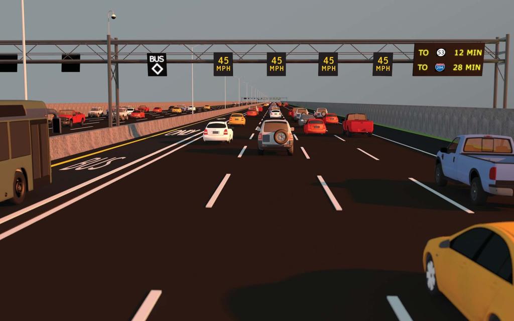
26 Common Corridor Concept Actively Manage All Lanes With ATM Lane-use control signals (LCS) over all lanes and shoulders Gantries spaced approx. every ½ mile Smaller DMS on every gantry 26

27 Lane-Use Control Signals 27
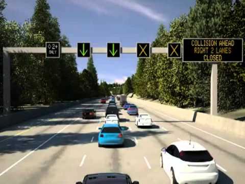
28

29 Dynamic Lane Use Control Warning drivers of upcoming lane closures and directing them to open lanes. Increase safety for drivers and incident responders. Traffic Enforcement 29
30 Speed Harmonization Dynamically changing advisory speeds based on road, traffic, and weather conditions. Maintain traffic flow and reduce risks of rearend collision that is caused by stop-and-go conditions. 30
31

32 Queue Warning Dynamic display of warning signs to alert drivers of downstream congestion and queues. Effectively use available roadway capacity and reduce likelihood of incidents associated with queuing. 32
33 I-290 Eisenhower Expressway HIGH OCCUPANCY TOLL LANE

34 I-290 MAINLINE GEOMETRICS


 6 am to 10 am Resurfacing 2010 Evening (PM) 4 pm to 7 pm 17 hours")
35 Illinois Department of Transportation Division of Highways Region One Interstate Route 290 The Interstate 290 corridor was originally constructed and opened to traffic in the 1950 s and was the first new multi-modal transportation corridor in the US. Interstate 290 has exceeded its life expectancy and is in need of reconstruction. Bridges and roadway over 50-years old Capacity issues resulting in substantial congestion and delays Interstate 290 is a major transportation link between Chicago and the western suburbs and also serves other transportation markets. Peak Traffic Hours Morning (AM) 6 am to 10 am Resurfacing 2010 Evening (PM) 4 pm to 7 pm 17 hours of congestion each weekday LOS based on IDOT April 2009 Loop Counts Original construction (still in place)


36 Purpose & Need Improve Facility Condition PURPOSE AND NEED Improve Access to Jobs Improve Connections Between Travel Modes Improve Mobility Improve Safety

37 Transportation Needs, Alternatives Summary Environmental considerations The communities are the environment Priority stay within existing right of way Environmental effects not a distinguishing factor Stakeholder concerns Access Economic benefits

38 Study Area Transit Transit Providers: - CTA Rail - CTA Bus - Pace Bus - Metra Rail 21% Work Trips vs. 12% Regionally


39 Transportation Needs, Alternatives Summary Alternatives development evaluation Three evaluation rounds, CTA Blue Line Vision Study Engineering considerations Evaluation rounds 1 and 2 conceptual alternatives, travel model Evaluation round 3 geometry Environmental Considerations Communities are the environment

40 ROUND 3 EVALUATION: PERSON THROUGHPUT 2040 Daily Person East-West Throughput: I-290, Arterials, Transit GP Lane HOV 2+ HOT 3+ HOT 3+ & TOLL +25, , , ,500 HOT 3+ provides the greatest person throughput improvement, followed by HOV2+ HOT 3+ best manages added capacity by encouraging HOV3+ vehicles and allowing SOVs who pay tolls when capacity is available HOV 2+ encourages carpools, but does not allow SOVs, which may result in underutilization of added capacity HOT 3+ & TOLL encourages HOV 3+, but results in diversions for those not wanting to pay tolls 40
41 ROUND 3 EVALUATION: ACCESSIBILITY 2040 # of additional Jobs Accessible within 60 minutes from Study Area (compared to 2040 No Build) Additional # of Jobs Accessible GP Lane HOV 2+ HOT 3+ HOT 3+ & TOLL Auto +82, , , ,000 Transit +24, , , ,000 HOT 3+ provides the greatest accessibility improvement, followed by HOV 2+ Improvement related to overall travel time improvements on I-290 and arterials HOT 3+ provides best balance of I-290 and arterial travel time improvements. 41

42 Recommended Preferred Alternative 88 Mannheim Rd. Des Plaines Austin Blvd. Racine Ave. 90/94 Existing Condition 4 lanes 3 lanes 3 lanes 4 lanes 4 lanes I-290 I mi 3.5 mi 2.1 mi 6.1 mi 0.5 mi Preferred Alternative HOT 3+ Express Bus 3 lanes 3 lanes Add 1 lane (HOT 3+) Convert 1 lane (HOT 3+) Blue Line Extension Add 1 lane (HOT 3+) Convert 1 lane (HOT 3+) 3 lanes 3 lanes 42


43 I-290 Mainline Preferred Alternative High Occupancy Toll 3+ and Supporting Transit Supporting Transit: Bus Feeder Service Blue Line Extension to Mannheim Initial service option - bus in managed lane I-290 corridor improvements will enable/leverage transit improvement *The Preferred Alternative is the same for all Maywood access options 43
44 Next Steps Visit website for updates: EisenhowerExpressway.com Overall I-290 Study DEIS Preparation Fall 2016 Public Hearing Winter 2017 Study Completion Summer 2017 Final design, ROW and construction not funded 44
45 QUESTIONS? 45
Corridor Advisory Group and Task Force Meeting #10. July 27, 2011
 Corridor Advisory Group and Task Force Meeting #10 July 27, 2011 1 Agenda Recap CAG/TF #9 Public Meeting #2 Summary Single Mode Alternatives Evaluation Results Next Steps 2 3 CAG/TF #9 Recap CAG /TF #9
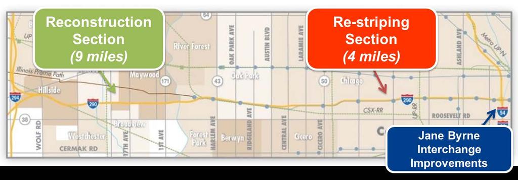
I-290 Phase I Study Area OAK PARK AVE AUSTIN BLVD. Reconstruction Area (9 miles) Oak Park RIDGELAND AVE CENTRAL AVE HARLEM AVE. Cicero.
 Oak Park RIDGELAND AVE CENTRAL AVE HARLEM AVE. Cicero.") RIDGELAND AVE OAK PARK AVE AUSTIN BLVD UP-RR BRC-RR ASHLAND AVE Study Area Map I-290 Phase I Study Area 294 UP RR Metra UP-W Illinois Prairie Path 38 Berkeley WOLF RD Hillside MANNHEIM RD Bellwood 290
RIDGELAND AVE OAK PARK AVE AUSTIN BLVD UP-RR BRC-RR ASHLAND AVE Study Area Map I-290 Phase I Study Area 294 UP RR Metra UP-W Illinois Prairie Path 38 Berkeley WOLF RD Hillside MANNHEIM RD Bellwood 290
Maywood Town Hall Meeting. May 4, 2016
 Maywood Town Hall Meeting May 4, 2016 1 AGENDA Overall I-290 Study Background Maywood Advisory Working Group (AWG) findings to date Noise Wall Update Next Steps 2 Questions? Study team members also available
Active Traffic Management and Part-Time Shoulder Use in Montgomery County, PA
 Active Traffic Management and Part-Time Shoulder Use in Montgomery County, PA PENN STATE TESC SESSION 8B MOVING PENNDOT AND PTC FORWARD DECEMBER 8, 2017 Agenda Define Active Traffic Management and describe
EXECUTIVE SUMMARY... vii 1 STUDY OVERVIEW Study Scope Study Area Study Objectives
 Contents EXECUTIVE SUMMARY... vii 1 STUDY OVERVIEW... 1-1 1.1 Study Scope... 1-1 1.2 Study Area... 1-1 1.3 Study Objectives... 1-3 2 EXISTING CONDITIONS... 2-1 2.1 Existing Freeway Conditions... 2-4 2.1.1
Washington DC Section of ITE Project Briefing
 Washington DC Section of ITE Project Briefing November 5, 2015 Renée Hamilton, VDOT, Deputy District Administrator I-66 Outside the Beltway Improvement Area Project Location Virginia 2 Purpose and Need
I-290 Phase I Study Village of Forest Park November 9, of 25
 I-290 Phase I Study Village of Forest Park November 9, 2015 1 of 25 I-290 Study Area Reconstruction Section (9 miles) Re-striping Section (4 miles) 13 miles West of Mannheim Road to Racine Avenue Connects
MnPASS System Today and the Future
 MnPASS System Today and the Future April 2010 By Nick Thompson Minnesota Department of Transportation Topics Minnesota s Current and Future MnPASS High Occupancy Toll Systems Overview of the MnPASS System
Corridor Advisory Group Meeting #21. October 15, 2015
 Corridor Advisory Group Meeting #21 October 15, 2015 Agenda CAG #20 Recap Study Timeline Round 3 Wrap-Up/Results Air Quality Noise Analysis Environmental Justice Preliminary Preferred Alternative Recommendation
A Federal Perspective on Congestion Pricing. Wayne Berman Federal Highway Administration July 8, 2010
 A Federal Perspective on Congestion Pricing Wayne Berman Federal Highway Administration July 8, 2010 Overview Background on Congestion Pricing Benefits and Experiences of Pricing Case Study Miami I-95
Priced Managed Lanes in America. October 2013
 Priced Managed Lanes in America October 2013 1 Priced Managed Lanes What are they? Where are they? Why do them? When to do them? Common issues Lessons learned What are Priced Managed Lanes? The subset
Transform 66 Project February 4, 2016 Partnering Conference Michigan Department of Transportation American Council of Engineering Companies
 Transform 66 Project February 4, 2016 Partnering Conference Michigan Department of Transportation American Council of Engineering Companies Susan Shaw, PE, CCM, DBIA Megaprojects Director Northern Virginia
Project Mobility - Route 3 South Express Toll Lanes. Industry Day Overview
 Project Mobility - Route 3 South Express Toll Lanes Industry Day Overview October 15, 2014 Today s Agenda Project Mobility Overview Design Alternatives and Construction Estimates Existing Traffic Congestion/Project
395 Express Lanes Extension
 395 Express Lanes Extension January 2016 Building a network of Express Lanes Project overview Add capacity on I-395 with addition of a third HOV lane and active traffic management Generate guaranteed transit
5. RUNNINGWAY GUIDELINES
 5. RUNNINGWAY GUIDELINES These guidelines should be considered collectively when making runningway decisions. A runningway is the linear component of the transit system that forms the right-of-way reserved
STATION #3 INITIAL ALTERNATIVES
 www.dot.il.gov www.eisenhowerexpressway.com STATIO #3 IHB RR Heavy Rail Transit (HRT) High capacity transit mode serving urban areas:» Steel wheeled, high performance electric powered rail vehicles» Right-of-way
I-66 Corridor Improvements Route 15 to I-495. November 2014
 I-66 Corridor Improvements Route 15 to I-495 November 2014 I-66 Corridor: Haymarket to the Beltway = Park and Ride Lots 2 Purpose and Need Improve multimodal mobility along the I-66 corridor by providing
DULLES AREA TRANSPORTATION ASSOCIATION (DATA) February 18, Susan Shaw, P.E., VDOT, Megaprojects Director
 February 18, Susan Shaw, P.E., VDOT, Megaprojects Director") DULLES AREA TRANSPORTATION ASSOCIATION (DATA) February 18, 2015 Susan Shaw, P.E., VDOT, Megaprojects Director I-66 Corridor Conditions Steady population growth Employment growth in activity centers Congestion
DULLES AREA TRANSPORTATION ASSOCIATION (DATA) February 18, 2015 Susan Shaw, P.E., VDOT, Megaprojects Director I-66 Corridor Conditions Steady population growth Employment growth in activity centers Congestion
I-290 Phase 1 Study Alternatives Tool Box.
 I-290 Phase 1 Study Alternatives Tool Box www.dot.il.gov www.eisenhowerexpressway.com I-290 Phase 1 Study Alternatives Tool Box www.dot.il.gov www.eisenhowerexpressway.com Page 1 Table of Contents: Page
State Road 54/56 Tampa Bay s Northern Loop. The Managed Lane Solution Linking I-75 to the Suncoast Parkway
 State Road 54/56 Tampa Bay s Northern Loop The Managed Lane Solution Linking I-75 to the Suncoast Parkway SUNCOAST PARKWAY Both I 75 and the Suncoast Parkway are planning, or in the process of constructing,
Purpose and Need Statement
 Purpose and Need Statement Interstate 55 Interstate 355 (Veterans Memorial Tollway) to I-90/94 (Dan Ryan Expressway) October 2017 1.0 Purpose of the Proposed Action The proposed action is to provide an
Freeway System Considerations
 Session 11 Jack Broz, PE, HR Green May 5-7, 2010 Freeway System Considerations Mainline Transit: Shoulder Operations, BRT, Stations HOV, HOT, UPA Interchanges Exit Ramps Entrance Ramps Bridges Local Crossings
I-25 PEL: CO Springs Denver South Connection. Presentation to Castle Rock Town Council
 I-25 PEL: CO Springs Denver South Connection Presentation to Castle Rock Town Council June 20, 2017 An Important Corridor to Colorado Links the state s two major metropolitan areas and communities between
Transportation Master Plan Advisory Task Force
 Transportation Master Plan Advisory Task Force Network Alternatives & Phasing Strategy February 2016 BACKGROUND Table of Contents BACKGROUND Purpose & Introduction 2 Linking the TMP to Key Council Approved
101 Corridor Managed Lanes
 101 Corridor Managed Lanes TA BOD Meeting May 5, 2016 Agenda Item 11a Presentation Outline 101 Corridor Profile System Deficiencies Background Managed Lanes Proposed Purpose and Need Alternatives Under
What are Managed Lanes?
 Express Lanes What are Managed Lanes? Highway facilities or a set of lanes where operational strategies are proactively implemented and managed in response to changing conditions. http://ops.fhwa.dot.gov/freewaymgmt/managedlanesvideo/index.htm
Defining Purpose and Need
 Advanced Design Flexibility Pilot Workshop Session 4 Jack Broz, PE, HR Green May 5-6, 2010 Defining Purpose and Need In your agency s project development process, when do design engineers typically get
Part-time Shoulder Use Guide
 1 Part-time Shoulder Use Guide FHWA Guide AASHTO SCOD, Baltimore, MD June 2016 DOTs Face Increasing Challenges 2 Performance Based Practical Design 3 PBPD is a decision making approach that helps agencies
Overview of 64 Express Lanes. Secretary of Transportation Aubrey Layne April 12, 2017
 Overview of 64 Express Lanes Secretary of Transportation Aubrey Layne April 12, 2017 2 More Choices for Motorists Coming December 2017 Purpose and Use Our purpose is two-fold: Reduce congestion by making
MCTC 2018 RTP SCS and Madera County RIFP Multi-Modal Project Eval Criteria GV13.xlsx
 MCTC 8 RTP SCS and Madera County RIFP Multi-Modal Project Eval Criteria GV.xlsx Madera County Transportation Commission Regional Transportation Plan / Sustainable Communities Strategy Multi-Modal Project
I-395 Express Lanes Northern Extension Project Crystal City Civic Association September 21, 2016
 I-395 Express Lanes Northern Extension Project Crystal City Civic Association September 21, 2016 Mike Snare, PE, Project Manager Virginia Department of Transportation GEC Michelle Holland, Megaprojects
Managed Lanes: A Popular and Effective Urban Solution. Ed Regan Presented by Susan Buse
 Managed Lanes: A Popular and Effective Urban Solution Ed Regan Presented by Susan Buse Overview of Managed Lanes First ML: SR 91 Orange County, CA 1996 Today About 23 Operating Projects in 9 States Basic
95 th Street Corridor Transportation Plan. Steering Committee Meeting #2
 95 th Street Corridor Transportation Plan Steering Committee Meeting #2 February 18, 2015 PURPOSE OF THE MEETING Update Steering Committee Present Community/Stakeholder Survey Results Present Transportation
PURPOSE AND NEED SUMMARY 54% Corridor Need 1. Corridor Need 2. Corridor Need 3. Corridor Need 4. Corridor Need 5
 SUMMARY PURPOSE AND NEED Chapel Hill Transit ridership has increased Buses operate every 4 minutes and have standing room only Exceeding seated capacity by 12% Corridor Need 1 by more than 20 percent between
Alternatives Public Workshop
 US 1 Express Lanes Project Development & Environment (PD&E) Study Alternatives Public Workshop August 2013 1 Today s Agenda Project Background and Overview Tier 1 Alternatives Development Tier 2 Decision-Making
Northern Virginia Express Lanes Design Challenges and Solutions. IBTTA Maintenance and Roadway Operations Workshop June 25, 2018
 Northern Virginia Express Lanes Design Challenges and Solutions IBTTA Maintenance and Roadway Operations Workshop June 25, 2018 Virginia Express Lanes Overview 60 miles of managed lanes (4 projects) Long
Regional Transportation Needs Within Southeastern Wisconsin
 Regional Transportation Needs Within Southeastern Wisconsin #118274 May 24, 2006 1 Introduction The Southeastern Wisconsin Regional Planning Commission (SEWRPC) is the official areawide planning agency
Durham Region Long Term Transit Strategy
 Durham Region Long Term Transit Strategy An adaptive, safe, reliable, frequent, accessible and desirable transit system that shapes and connects Durham Region and beyond in an economically and environmentally
Today s Agenda. Welcome & Introductions. I-526 Lowcountry Corridor Update. Table Discussions. Next Steps / Conclusion
 SCDOT Turns 100! SCDOT Turns 100! Today s Agenda Welcome & Introductions I-526 Lowcountry Corridor Update Table Discussions Next Steps / Conclusion Project Limits I-526 Lowcountry Corridor Project Description
Managed Lanes: A National Perspective Managed Lane Strategies
 Managed Lanes: A National Perspective Managed Lane Strategies Use the following control strategies to manage a lane(s) to provide a reliable transportation option: Eligibility/occupancy Access control
Bus Rapid Transit Plans
 Twin Cities Region Bus Rapid Transit Plans ULI Minnesota Workshop Connecting Bus Rapid Transit to the Community December 15, 2009 John Levin Director of Service Development Metro Transit Metropolitan Area
Part-time Shoulder Use Guide
 1 Part-time Shoulder Use Guide FHWA Guide AASHTO SCOTE, Savannah GA June 2016 DOTs Face Increasing Challenges 2 Performance Based Practical Design 3 PBPD is a decision making approach that helps agencies
I-25 South Gap Project Monument to Castle Rock
 I-25 South Gap Project Monument to Castle Rock Project Overview Castle Rock Town Council April 3, 2018 by Chuck Attardo I-25 South: Monument to C-470 An Important Corridor to Colorado Links the state s
95 th Street Corridor Transportation Plan. Steering Committee Meeting
 95 th Street Corridor Transportation Plan Steering Committee Meeting August 11, 2014 PROJECT OBJECTIVES Develop a Transportation and Economic Plan for the 95 th Street Corridor Improve public transit efficiency
Making Great Urban Streets Confessions of a Highway Engineer. Timothy R. Neuman.. P.E. Chief Highway Engineer CH2M HILL
 Making Great Urban Streets Confessions of a Highway Engineer Timothy R. Neuman.. P.E. Chief Highway Engineer CH2M HILL Isn t this a Great Street? Characteristics of a Great Street It is a transportation
MnPASS Study II. September 2010
 MnPASS Study II September 2010 final report MnPASS System Study Phase 2 prepared for Minnesota Department of Transportation prepared by Cambridge Systematics, Inc. 100 CambridgePark Drive, Suite 400 Cambridge,
STANLEY STREET December 19, 2017
 STANLEY STREET December 19, 2017 Welcome Mike Wiza, Mayor Scott Beduhn, Director of Public Works Agenda 1. Introduction 2. Existing Roadway Conditions 3. Current Alternative Improvements 4. Summary of
Freeway Improvement Project
 CapCity Corridor History and Milestones CapCity Partners CapCity Origin and Destination analysis Origins and Destinations Destinations based on Origins North of I-80 8% O & D data prepared by SACOG Origins
1. Operate along freeways, either in regular traffic lanes, in high-occupancy vehicle (HOV) lanes, or along the shoulders.
 lanes, or along the shoulders.") Most decisions about whether or not to use transit involve time and cost, and most transit services are slower than travel by private vehicle. However, when transit is faster or nearly as fast as travel
Most decisions about whether or not to use transit involve time and cost, and most transit services are slower than travel by private vehicle. However, when transit is faster or nearly as fast as travel
Highway 17 Transportation Improvement Study
 Final Report Highway 17 Transportation Improvement Study prepared for Santa Cruz County Regional Transportation Commission (SCCRTC) prepared by Planning and Engineering, Inc. 1155 North First Street, Suite
Highway 217 Corridor Study. Phase I Overview Report
 Highway 217 Corridor Study Phase I Overview Report November 3, 24 BACKGROUND AND OVERVIEW Study purpose The Highway 217 Corridor Study is developing multi-modal transportation solutions for traffic problems
Comprehensive Collection of Stakeholder Alternatives by Mode
 2011 Illinois Department of Transportation Comprehensive Collection of Stakeholder Alternatives by Mode October 2009 January 2011 www.dot.il.gov www.eisenhowerexpressway.com FILEY RD FILEY RD IHB RR 2
Planning Study SR 976. Project Advisory Team Meeting May 24, 2017
 ` SR 976 BIRD ROAD/SW 40TH STREET FROM SR 821/HEFT TO SR 5/US-1 Miami-Dade County, Florida FPID No.: 434845-4-22-01 Planning Study Project Advisory Team Meeting May 24, 2017 1 Agenda Introductions Project
The Road Less Traveled: Exploring Congestion Pricing in Chicagoland
 Study conducted by: Illinois Tollway Metropolitan Planning Council Wilbur Smith Associates Study Results July 2010 The Road Less Traveled: Exploring Congestion Pricing in Chicagoland THE ROAD LESS S TRAVELED
Appendix C. NORTH METRO STATION AREA TRAFFIC IMPACT STATEMENT 88th Avenue Station
 Appendix C NORTH METRO STATION AREA TRAFFIC IMPACT STATEMENT 88th Avenue Station Prepared for: Regional Transportation Department and URS Corporation as part of the North Metro EIS David Evans and Associates,
TRB Managed Lanes Conference May 22 24, 2012, Oakland, CA
 HOT LLanes and d TTransit i P f Performance TRB Managed Lanes Conference May 22 24, 2012, Oakland, CA Miami UPA Transit Results (2008 2010 Data) Miami UPA Transit Improvements 2 new routes Dade-Broward
North Coast Corridor:
 North Coast Corridor: Connecting People, Transportation & Environment Legislative Hearing: 11.8.10 1 North Coast Corridor Region s Lifeline A Regional Strategy Mobility, Economy & Environment North Coast
The Future of All Electronic Tolling Brian Patno Raytheon ITS Texas October 26, 2012
 The Future of All Electronic Tolling Brian Patno Raytheon ITS Texas October 26, 2012 Copyright 2012 Raytheon Company. All rights reserved. Customer Success Is Our Mission is a registered trademark of Raytheon
IH 85 EXPRESS LANES ATLANTA, GA USDOT Congestion Reduction Demonstration Program Grant ($110M)
") IH 85 EXPRESS LANES ATLANTA, GA USDOT Congestion Reduction Demonstration Program Grant ($110M) HOV to HOT: 15 miles Convert from 2+ HOV to managed (3+ free) Project includes Express Lane component, new
IH 85 EXPRESS LANES ATLANTA, GA USDOT Congestion Reduction Demonstration Program Grant ($110M) HOV to HOT: 15 miles Convert from 2+ HOV to managed (3+ free) Project includes Express Lane component, new
Part-Time Shoulder Use
 TRANSPORTATION RESEARCH BOARD Part-Time Shoulder Use Thursday, October 12, 2017 2:00-3:30PM ET The Transportation Research Board has met the standards and requirements of the Registered Continuing Education
WELCOME. Stakeholder Involvement Group Meeting #2 Round Lake Public Works October 24, 2018
 WELCOME Stakeholder Involvement Group Meeting #2 Round Lake Public Works October 24, 2018 MEETING AGENDA 1. Welcome and Introductions 2. Study Progress Update 3. Problem Statement 4. Technical Analysis
Initial Alternatives Identification and Evaluation Report. November 2011 APPENDIX B. Summary of Stakeholder Single Mode Suggestions
 Initial Alternatives Identification and Evaluation Report ovember 2011 APPEDIX B Summary of Stakeholder Single Mode Suggestions 2011 Illinois Department of Transportation Summary of Stakeholder Alternatives
Overview. Illinois Bike Summit IDOT Complete Streets Policy Presentation. What is a Complete Street? And why build them? And why build them?
 Overview Illinois Bike Summit IDOT Complete Streets Policy Presentation Aren Kriks, P.E. District One Bicycle Coordinator and Bureau of Programming Project Engineer History of Complete Streets IDOT Policy
INTRODUCTION. The focus of this study is to reduce congestion and improve mobility for all modes of transportation. Figure ES-1 Study Corridor Map
 INTRODUCTION The I-280 Corridor Study is a highway planning study led by Santa Clara VTA, in partnership with the City of Cupertino and in coordination with other stakeholders in the study area. The study
ROADSOADS CONGESTION HAMPTON SYSTEMYSTEM MANAGEMENT. Part II Roadway Congestion Analysis Mitigation Strategies and Evaluation
 HAMPTON ROADSOADS CONGESTION MANAGEMENT SYSTEMYSTEM Part II Roadway Congestion Analysis Mitigation Strategies and Evaluation Presented by: Dwight Farmer, PE Deputy Executive Director, Transportation April
Public Hearing Tarrant County. October 11 th, 2012
 Public Hearing Tarrant County October 11 th, 2012 Public Hearing Agenda Welcome and Project Overview Ms. Maribel P. Chavez, P.E. District Engineer Texas Department of Transportation Fort Worth District
I-105 Corridor Sustainability Study (CSS)
") I-105 Corridor Sustainability Study (CSS) Metro Streets and Freeways Subcommittee March 21, 2019 Gary Hamrick Cambridge Systematics, Inc. I-105 CSS Project History & Background Funded by Caltrans Sustainable
I-105 Corridor Sustainability Study (CSS) Metro Streets and Freeways Subcommittee March 21, 2019 Gary Hamrick Cambridge Systematics, Inc. I-105 CSS Project History & Background Funded by Caltrans Sustainable
CHAPTER 2G. PREFERENTIAL AND MANAGED LANE SIGNS
 2011 Edition - Revision 2 Page 275 Section 2G.01 Scope CHAPTER 2G. PREFERENTIAL AND MANAGED LANE SIGNS 01 Preferential lanes are lanes designated for special traffic uses such as high-occupancy vehicles
THE FUTURE OF THE TxDOT ROADWAY DESIGN MANUAL
 THE FUTURE OF THE TXDOT ROADWAY DESIGN MANUAL Kenneth Mora, P.E. (Design Division) 10/10/2017 Table of contents 1 2 Reduction in FHWA design controlling criteria Innovative Intersection Guidance 3-7 8-42
I-20 ODESSA-MIDLAND CORRIDOR STUDY. Public Meeting for Schematic Design
 I-20 ODESSA-MIDLAND CORRIDOR STUDY Public Meeting for Schematic Design The environmental review, consultation, and other actions required by applicable Federal environmental laws for this project are being,
Interstate 66 Tier 1 Environmental Impact Statement (EIS)
") WELCOME Welcome to the second Citizen Information Meeting for the Tier 1 Environmental Impact Statement (EIS). As an integral part in the environmental study process, the study team is seeking your comments
WELCOME Welcome to the second Citizen Information Meeting for the Tier 1 Environmental Impact Statement (EIS). As an integral part in the environmental study process, the study team is seeking your comments
MOBILITY WORKSHOP. Joint City Council and Transportation Commission May 5, 2014
 MOBILITY WORKSHOP Joint City Council and Transportation Commission May 5, 2014 Review of General Plan M-1 Develop world-class transit system M-3 Maintain/enhance pedestrian-oriented City M-4 Create comprehensive
Maryland State Highway Mobility Report. Morteza Tadayon
 Maryland State Highway Mobility Report Morteza Tadayon Background Mobility is a Key Performance Area (KPA) in the SHA Business Plan SHA adopts a performance based approach Monitors Highway System to identify
Turnpike Projects in Palm Beach County. Palm Beach TPA Update September 20, 2018
 Turnpike Projects in Palm Beach County Palm Beach TPA Update September 20, 2018 Agenda Background Funded Projects Future Project Status Widenings Interchanges Express Lanes Phasing 2 Background 45 Miles
Enhancing Return on Investment for MnPASS Express Lanes
 Enhancing Return on Investment for MnPASS Express Lanes Minnesota s Transportation Conference February 28, 2018 mnpass.org Agenda MnPASS Express Lane Background MnPASS System Update Enhancing Return on
95 Express Annual Operations Report: Fiscal Year
 95 Express Annual Operations Report: Fiscal Year 2014-2015 General The 95 Express Program completed its sixth full Fiscal Year of operations in June 2015. For the FDOT, its Fiscal Year (FY) is from July
Road Diets FDOT Process
 Florida Department of TRANSPORTATION Road Diets FDOT Process Humberto Castillero, PE, PTOE Roadway Design Office Purpose of Guide Develop a statewide lane elimination review process Balance state & local
6/14/2013. Welcome. to the US 75 Corridor Study. Public Meeting. US 75 Corridor Study Area
 Welcome to the US 75 Corridor Study Public Meeting US 75 Corridor Study Area 1 Existing and Future Congestion Levels 2012 2035 A do-nothing approach does not address the severe congestion in the region
I-395 Express Lanes Northern Extension Project Public Hearings
 I-395 Express Lanes Northern Extension Project Public Hearings Susan Shaw, PE, Megaprojects Director Virginia Department of Transportation Amanda Baxter, Special Projects Manager Virginia Department of
DRAFT. Memo. Range of the Alternatives Considered in the EIS
 Memo Date: Friday, December 09, 2016 Project: To: From: Subject: State Route 30 EIS UDOT Vince Izzo This memorandum summarizes the draft State Route (S.R.) 30 Level 1 screening results. A more detailed
Roadways. Roadways III.
 Introduction 97 Roadway Design Principles 98 Safe Speeds 99 Optimizing of Street Space 00 Minimum Lane Widths in the City of Boston 02 Design Features that Reduce Operating Speeds 05 Travel Lanes Transit
Santa Clara I-280 CORRIDOR STUDY
 Santa Clara I-280 CORRIDOR STUDY OCTOBER 2017 PREPARED BY: 1.1 Background The I-280 Corridor Study within Santa Clara County is a high-level highway planning study led by the Santa Clara VTA, in partnership
City of Wayzata Comprehensive Plan 2030 Transportation Chapter: Appendix A
 A1. Functional Classification Table A-1 illustrates the Metropolitan Council s detailed criteria established for the functional classification of roadways within the Twin Cities Metropolitan Area. Table
PERFORMANCE ANALYSIS of The Draft 2015 CLRP
 Item 9 PERFORMANCE ANALYSIS of The Draft CLRP Presentation to the Transportation Planning Board September 16, CLRP Performance Analysis 1 What is the Long-Range Transportation Plan (CLRP)? The CLRP identifies
Bay to Bay Boulevard Complete Streets Project
 Bay to Bay Boulevard Complete Streets Project Dale Mabry Highway to Bayshore Boulevard February 08, 2018 Photo Source: Tampa Bay Times Alessandra Da Pra Meeting Format Introduction Resurfacing Information
Mission Bay Loop (MBL) Public Meeting
 Public Meeting") Mission Bay Loop (MBL) Public Meeting La Scuola Internazionale di San Francisco, November 18, 2014 Frequently Asked Questions 1. When would construction have to start before the SFMTA loses TIGER funds?
Mission Bay Loop (MBL) Public Meeting La Scuola Internazionale di San Francisco, November 18, 2014 Frequently Asked Questions 1. When would construction have to start before the SFMTA loses TIGER funds?
MnPASS System Study Phase 2
 This document is made available electronically by the Minnesota Legislative Reference Library as part of an ongoing digital archiving project. http://www.leg.state.mn.us/lrl/lrl.asp MnPASS Study II September
Design of Turn Lane Guidelines
 Design of Turn Lane Guidelines CTS Transportation Research Conference May 24, 2012 Howard Preston, PE Minnesota Department of Transportation Research Services Office of Policy Analysis, Research & Innovation
Purpose and Need. Chapter Introduction. 2.2 Project Purpose and Need Project Purpose Project Need
 Chapter 2 Purpose and Need 2.1 Introduction The El Camino Real Bus Rapid Transit (BRT) Project (Project) would make transit and other transportation improvements along a 17.6-mile segment of the El Camino
INNOVATIVE INTERSECTION SOLUTIONS. Jay Bockisch, PE, PTOE Senior Associate
 INNOVATIVE INTERSECTION SOLUTIONS Jay Bockisch, PE, PTOE Senior Associate INNOVATIVE INTERSECTION SOLUTIONS Innovative intersection overview Case studies Continuous flow intersection Modern roundabouts
I-105 ExpressLanes Project
 I-105 ExpressLanes Project Public Scoping Meetings March 2018 Introduction to Scoping This process is your opportunity to give us your thoughts on: The purpose and need for the proposed improvements The
ROUTES 55 / 42 / 676 BUS RAPID TRANSIT LOCALLY PREFERRED ALTERNATIVE
 ROUTES 55 / 42 / 676 BUS RAPID TRANSIT LOCALLY PREFERRED ALTERNATIVE April, 2012 1 INTRODUCTION The need for transit service improvements in the Routes 42/55/676 corridor was identified during the Southern
WHAT IFS: Over the course of
 WHAT IFS: Over the course of the 422plus Project certain questions have arisen multiple times at meetings, briefings and on-line at the website. Most of these questions start with WHAT IF. WHAT IF vehicle
JONESBORO HIGHWAY 63 HIGHWAY 18 CONNECTOR STUDY
 JONESBORO HIGHWAY 63 HIGHWAY 18 CONNECTOR STUDY Craighead County May 2007 JONESBORO HIGHWAY 63 HIGHWAY 18 CONNECTOR STUDY Craighead County May 2007 Prepared by Planning and Research Division Arkansas State
Modal Interrelationships: A bicycle lane is proposed between Harrington Ave and Swanns Station Rd.
 DRAFT PROJECT PAGE July 12, 2007 Main St / Broadway Rd (SR 1579) Project Statement Project Recommendation: From Avent Ferry Rd (NC 42) to the Harnett County line, Broadway Rd/Main St is recommended to
Charlotte Region Fast Lanes Study Phase III
 Charlotte Region Fast Lanes Study Phase III Stakeholder Workshop #3 December 13, 2012 Fast Lanes Study, Phases I and II Performed between 2007 and 2009 Evaluated all types of managed lanes (HOV, HOT, truck-only
7.0 FREEWAYS CONGESTION HOT SPOT PROBLEM & IMPROVEMENT PROJECT ANALYSIS & DEFINITION
 7.0 FREEWAYS CONGESTION HOT SPOT PROBLEM & IMPROVEMENT PROJECT ANALYSIS & DEFINITION 7.1 INTRODUCTION & METHODOLOGY FEASIBILITY REPORT Congestion hot spot problem locations have been assessed using the
DESIGN MEMORANDUM WITH DESIGN EXCEPTIONS SP SP
 DRAFT NOT FINAL (Note: document was not finalized due to an eastbound stopping site distance design issue that requires more detailed bridge and roadway design considerations. This discussion starts on
Clackamas County Comprehensive Plan
 ROADWAYS The County s road system permits the movement of goods and people between communities and regions, using any of a variety of modes of travel. Roads provide access to virtually all property. They
Developed by: The American Traffic Safety Services Association (ATSSA) 15 Riverside Parkway, Suite 100 Fredericksburg, VA
 15 Riverside Parkway, Suite 100 Fredericksburg, VA") Addendum Developed by: The American Traffic Safety Services Association (ATSSA) 15 Riverside Parkway, Suite 100 Fredericksburg, VA 22406-1022 800-272-8772 This material is based upon work supported by
Addendum Developed by: The American Traffic Safety Services Association (ATSSA) 15 Riverside Parkway, Suite 100 Fredericksburg, VA 22406-1022 800-272-8772 This material is based upon work supported by