MONTGOMERY COUNTY PLANNING DEPARTMENT THE MARYLAND-NATIONAL CAPITAL PARK AND PLANNING COMMISSION
|
|
|
- Warren Singleton
- 5 years ago
- Views:
Transcription
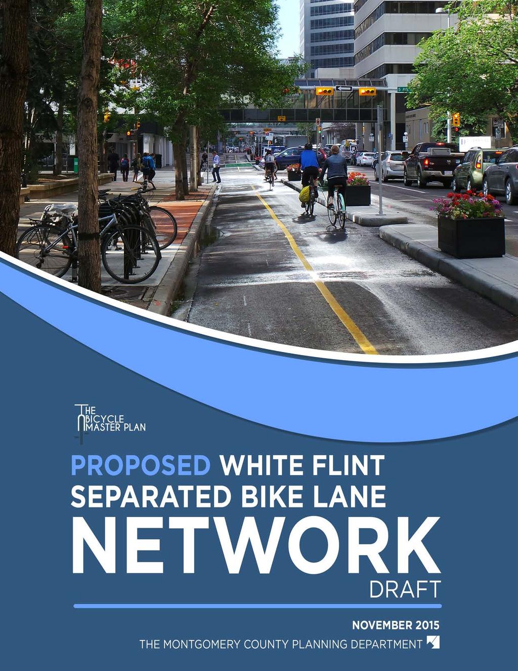
1 MONTGOMERY COUNTY PLANNING DEPARTMENT THE MARYLAND-NATIONAL CAPITAL PARK AND PLANNING COMMISSION MCPB Item No. 5 Date: 12/3/15 Draft White Flint Separated Bike Lanes Network David Anspacher, Functional Planning & Policy, david.anspacher@montgomeryplanning.org, Tom Autrey, Supervisor, Functional Planning and Policy, thomas.autrey@montgomeryplanning.org, Pam Dunn, Chief, Functional Planning and Policy, pamela.dunn@montgomeryplanning.org, Completed: 11/23/15 Recommendation Receive stakeholder input and provide feedback on the Draft White Flint Separated Bike Lane Network. Summary A network of low-stress routes connecting people to the places they want to go without exceeding their tolerance for traffic stress is needed to encourage bicycling as a mainstream mode of travel. The White Flint Separated Bike Lane Network would create a low-stress bicycling network that circulates throughout the Sector Plan area, connecting to the existing Metrorail station, proposed Bus Rapid Transit (BRT) stations, existing bikeways such as the Bethesda Trolley Trail and the Montrose Parkway shared use path, and that facilitates connections to the surrounding residential neighborhoods. Background The Bicycle Master Plan Team is advancing work both in the White Flint Sector Plan area and Life Sciences Center District due to the fast pace of change in these areas so that opportunities to construct segments of a separated bike lane network can be pursued in conjunction with development and capital projects ahead of the Bicycle Master Plan which is expected to be approved in Why are Separated Bike Lanes Needed? Traditionally, bicycle planning in Montgomery County has consisted of two types of bikeways, but each has drawbacks that limit their ability to encourage bicycling, especially in urban areas: Conventional bike lanes are a portion of a roadway that has been designated by striping, signing and pavement markings for exclusive use for bicycling. o Drawback: Many people are deterred from bicycling in conventional bike lanes when traffic volumes or speeds are high, because striping does not offer much protection from traffic. And in urban areas riding in bike lanes can be stressful if the bike lane is blocked by a delivery vehicle or when cars pull in and out of on-street parking. Shared use paths are a paved path that is typically 10 feet wide, designated for shared use by bicycles and pedestrians. 1
 have been embraced in urban areas as a preferred bikeway because they provide dedicated space for")
2 o Drawback: While shared use paths may be a comfortable bikeway type in areas with less activity, they are less comfortable for both bicyclists and pedestrians in activity centers. Over the past five years, separated bike lanes (also known as cycle tracks or protected bike lanes) have been embraced in urban areas as a preferred bikeway because they provide dedicated space for bicycling that is physically separated from motor vehicles and pedestrians. In the Washington DC region separated bike lanes exist on multiple roads, including: District of Columbia: Pennsylvania Avenue, 15 th Street NW, L Street NW, M Street NW, and 1 st Street NE. Arlington: Eads Street and South Hayes Street. The first separated bike lane in Montgomery County opened on Woodglen Drive in White Flint in the fall of The Proposed Network The Woodglen Drive Separated Bike Lane The White Flint Separated Bike Lane Network is shown in the image below. 2

3 Separated bike lanes are proposed on three types of roads: 1. Roads with master-planned bike lanes that would be upgraded to separated bike lanes Roads in this category are already recommended to have bike lanes in the White Flint Sector Plan. Since bike lanes are typically 5.5 to 6 feet wide in Montgomery County and separated bike 3

4 lanes in a high-demand area are recommended to be 7 feet wide to allow passing, up to 1.5 additional feet are needed on each side of the road. (The separation could be provided by relocating the bike lanes on the other side of the landscape panel see image below.) This space can be gained by narrowing the traffic lanes per Bill (the Urban Road Code bill). Upgrading to separated bike lanes on these roads would not require a reduction in the number of travel lanes or an expansion of the master-planned right-of-way. Roads in this category include: Nicholson Lane from Old Georgetown Road to Nebel Street Nebel Street from Randolph Road to Rockville Pike Edson Lane from Rockville Pike to Woodglen Drive Old Georgetown Road from Rockville Pike to Nebel Street 2. Roads with existing bike lanes that would be upgraded to separated bike lanes Roads in this category currently have striped bike lanes even though such lanes were not recommended in the White Flint Sector Plan. They would be upgraded to separated bike lanes. Roads in this category include: Marinelli Road from Executive Blvd to Rockville Pike Security Lane from Woodglen Drive to Rockville Pike 3. Roads without existing or master-planned bike lanes Three additional roads without existing bike lanes or a master plan recommendation for bike lanes would be included in the network of separated bike lanes: Rockville Pike from Edson Lane to Montrose Parkway Woodglen Drive Extended from Nicholson Lane to Marinelli Street Marinelli Road from Rockville Pike to Nebel Street One-Way Separated Bike Lane in Boulder Colorado 4

5 Prioritization Staff was also asked by Council staff to include a prioritization section to help inform funding for White Flint bikeways in the Capital Improvements Program. The recommendations are divided into three tiers on page 9: Tier One includes those bikeways that must be substantially completed to open Stage 2 of the White Flint Sector Plan, as well as those connecting various areas to the White Flint Metrorail Station. Tier Two includes those bikeways that are important for connectivity, but are not required to begin Stage 2 of the Sector Plan. Tier Three includes recommendations that are important to complete as part of the MD 355 BRT transit corridor and are, therefore, longer term recommendations. Comments from the Montgomery County Department of Transportation On September 10, 2015, the Planning Board recommended adding separated bike lanes on four roads in the White Flint West project Mandatory Referral. These included Old Georgetown Road, Hoya Street (now Towne Road), Executive Blvd, and East Jefferson Street, and are included on the map above. Acting Director of the Department of Transportation Al Roshdieh expressed support for the White Flint Separated Bike Lane Network in a letter dated October 5, 2015 (See Attachment A), but requested the following language regarding the White Flint West Phase 2 roads: The Montgomery County Department of Transportation has two projects either under contract for construction or nearing design completion, consistent with the 2010 White Flint Sector Plan, as of the 5
6 publication of this document. The recommendations for separated bike lanes along the following four segments are expressed with the understanding that the associated active projects are not able to incorporate the facilities as proposed within this document without significant delays and greatly increased costs due to complete redesign, which also requires changes in current State Highway Administration policy. For these four segments, MCDOT has indicated that they will continue to proceed under the direction of the 2010 White Flint Sector Plan. The facilities proposed by this document for these four segments will be implemented under separated projects at a future time. Old Georgetown Road from Nicholson Lane to Rockville Pike. Hoya Street from Montrose Parkway to Old Georgetown Road. Executive Blvd west of Old Georgetown Road. Executive Blvd (realigned) from Marinelli Street to Old Georgetown Road. We have incorporated a slightly modified version of this into the document: As of October 2015, tthe Montgomery County Department of Transportation (MCDOT) has two projects either under contract for construction or nearing design completion, consistent with the 2010 White Flint Sector Plan, as of the publication of this document. The recommendations for separated bike lanes along the following four segments are expressed with the understanding from MCDOT that the associated active projects are not able to incorporate the facilities as proposed within this document without significant delays and greatly increased costs due to complete redesign, which also requires changes in current State Highway Administration policy. For these four segments, MCDOT has indicated that they will continue to proceed under the direction of the 2010 White Flint Sector Plan. The facilities proposed by this document for these four segments will be implemented under separated projects at a future time. Current Status The Montgomery County Department of Transportation has agreed to recommend design of the separated bike lane network in the FY Capital Improvements Program. Next Steps The bikeway network recommended in this document and any comments from the Planning Board will be incorporated into a Working Draft of the Bicycle Master Plan in late
7
8
9
10 Proposed White Flint Separated Bike Lane Network (Draft) November 2015 Abstract This draft report includes a proposed separated bike lane network for the White Flint Sector Plan area. Separated bike lanes create a low-stress environment for cyclists because they provide physical separation from both traffic and pedestrians. Source of Copies: montgomeryplanning.org/bikeplan
11 TABLE OF CONTENTS 5 SEPARATED BIKE LANE PROPOSAL 9 PRIORITIZATION 10 TECHNICAL DISCUSSION

12 Indianapolis Cultural Trail
13 Bicycling as a mode of transportation is experiencing a resurgence throughout the United States, especially in urbanized areas. Driven by changing travel patterns, investments in low-stress bicycling infrastructure and popularity of bikeshare programs, the number of trips by bicycling has grown steadily over the past 15 years. Montgomery County continues to make substantial investments in bicycling infrastructure and is well-positioned to emerge as a leader in bicycling among suburban jurisdictions. A high-quality bicycling network is a critical component of achieving a number of County indicators, including non-auto driver mode share (NADMS) goals required in the staging elements of several master plans, and air quality and public health indicators. Furthermore, a separated bicycle network is increasingly a driver of economic activity and potentially a differentiator for the White Flint area. Several surveys reveal that the public increasingly wants to live in walkable and bikeable places with convenient access to amenities and transit. The Montgomery County Planning Department began working on the Bicycle Master Plan in July 2015 with the goal of developing a low-stress bicycle network that can make cycling a mainstream choice for the majority of the County s residents and employees. One critical component of this plan is evaluating bikeway types that were not a part of the planning toolkit when the Countywide Bikeways Functional Master Plan (a precursor to the current Bicycle Master Plan) was approved in These newer types include separated bike lanes (also known as cycle tracks or protected bike lanes), which are preferred in many urban areas because they provide separation from motor vehicles and pedestrians. This separation may be vertical, such as curbs or bollards; horizontal, such as a landscape panel or a parking lane; or a combination of both. Separated bike lanes may be in a one-way or a two-way configuration. PROPOSED WHITE FLINT SEPARATED BIKE LANE NETWORK (DRAFT) 5

14 A two-way separated bike lane on Hornby Street, Vancouver, British Columbia Montgomery County residents and employees are more likely to bicycle in low-stress environments, so improving bicycling throughout the County requires developing safe, low-stress connections between activity centers, transit facilities and neighborhoods. Based on the analysis in this document, the current master-planned bikeway network in White Flint would benefit greatly from modifications to the proposed facilities in order to encourage cycling as a mainstream choice. Due to the pace of development in White Flint, the Planning Department is advancing work in this area of the County so that meaningful opportunities to construct segments of the preferred bike network are not lost before the Bicycle Master Plan is completed. This document identifies an initial phase of the bikeway network. It can be implemented without an amendment to the master plan because it: 1. Can be constructed within the right-of-way recommended in the White Flint Sector Plan. 2. Will have little, if any, additional impact on vehicular traffic in the White Flint area. 3. The Countywide Bikeways Functional Master Plan (page 29) allows for flexibility. The map (right) shows the proposed separated bike lane network. 6 PROPOSED WHITE FLINT SEPARATED BIKE LANE NETWORK (DRAFT)
")
15 PROPOSED SEPARATED BIKE LANE NETWORK PROPOSED WHITE FLINT SEPARATED BIKE LANE NETWORK (DRAFT) 7


16 Two-way separated bike lane in Washington, DC One-way separated bike lane in Temple City, CA (Source: Joe Linton) 8 PROPOSED WHITE FLINT SEPARATED BIKE LANE NETWORK (DRAFT)
17 PRIORITIZATION The table below prioritizes the separated bike lane network for different locations in White Flint according to three tiers. Tier One includes those bikeways that must be substantially completed to open Stage 2 of the White Flint Sector Plan, as well as those connecting various areas to the White Flint Metrorail Station. Tier Two includes those bikeways that are important for connectivity, but are not required to begin Stage 2 of the sector plan. Tier Three includes recommendations that are important to complete as part of the MD 355 bus rapid transit network and are, therefore, longer term recommendations. Of course, there may be opportunities to advance some of the bikeways noted in Tier 2 and Tier 3 (for example, the Montgomery County Department of Transportation s separated bike lane projects on Nebel Street and Woodglen Drive), and this prioritization is not intended to preclude their construction. Tier Limits Rationale Tier One Nicholson Lane Old Georgetown Rd to CSX tracks White Flint Sector Plan Staging Requirement Old Georgetown Road Rockville Pike to Nebel St White Flint Sector Plan Staging Requirement Marinelli Road Executive Blvd to Rockville Pike Connection to White Flint Metrorail Station Marinelli Road Rockville Pike to Nebel St Connection to White Flint Metrorail Station Tier Two Nebel Street Randolph Rd to Rockville Pike North-South Connection Edson Lane Rockville Pike to Woodglen Dr Connects to White Flint Mall / BRT Station Woodglen Drive Ext Nicholson Ln to Marinelli St Extension of North Bethesda Trail Tier Three Rockville Pike Edson Ln to Montrose Pkwy Major North-South Connection Security Lane Woodglen Dr to Rockville Pike Connection to Future BRT Station PROPOSED WHITE FLINT SEPARATED BIKE LANE NETWORK (DRAFT) 9
18 TECHNICAL DISCUSSION The analysis in this report is based on an approach that quantifies the anxiety and danger that bicyclists feel when they ride close to traffic. This level of traffic stress (LTS) methodology was developed in 2012 by the Mineta Transportation Institute and San Jose State University. It assigns a numeric stress level to streets (and other places where people can bicycle, like trails) based on attributes that include traffic speed, traffic volume, number of lanes, frequency of parking turnover, ease of intersection crossings and other characteristics. A quiet residential street with a 25-mileper-hour speed limit presents a low-stress setting for cyclists riding in the roadway, but a six-lane highway with a 40-mile-per-hour speed limit creates a high-stress environment for cyclists who must share the roadway with traffic. The proposed network of separated bike lanes would create a low-stress bicycling environment through much of the White Flint Sector Plan area. Recommendations for separated bike lanes fall into three categories: 1 Upgrade master-planned bike lanes to separated bike lanes Roads in this category are already recommended to have bike lanes in the White Flint Sector Plan. Since bike lanes are typically 5.5 to 6 feet wide in Montgomery County and separated bike lanes in a high-demand area are 7 feet wide, 1.5 additional feet are needed on each side of the road to upgrade to separated bike lanes. This space can be gained by narrowing the traffic lanes per Bill (the Urban Road Code bill). Upgrading to separated bike lanes would not require a reduction in the number of travel lanes or an expansion of the master-planned right-of-way. Roads in this category include: Nicholson Lane from Old Georgetown Road to Nebel Street Nebel Street from Randolph Road to Rockville Pike Edson Lane from Rockville Pike to Woodglen Drive Old Georgetown Road from Rockville Pike to Nebel Street Upgrade existing bike lanes to separated bike lanes Roads in this category currently have striped bike lanes even though such lanes were not recommended in the White Flint Sector Plan. They would be upgraded to separated bike lanes. Roads in this category include: Marinelli Road from Executive Blvd to Rockville Pike 2 Security Lane from Woodglen Drive to Rockville Pike 10 PROPOSED WHITE FLINT SEPARATED BIKE LANE NETWORK (DRAFT)
19 Add separated bike lanes on additional roads Three additional roads would be included in the network of separated bike lanes: Rockville Pike from Edson Lane to Montrose Parkway Woodglen Drive Extended from Nicholson Lane to Marinelli Street 3 Marinelli Road from Rockville Pike to Nebel Street As of October 2015, the Montgomery County Department of Transportation (MCDOT) has two projects either under contract for construction or nearing design completion consistent with the 2010 White Flint Sector Plan. The recommendations for separated bike lanes along the following four segments are expressed with the understanding from MCDOT that the associated active projects are not able to incorporate the facilities as proposed within this document without significant delays and greatly increased costs due to complete redesign, which also requires changes in current State Highway Administration policy. For these four segments, MCDOT has indicated that they will continue to proceed under the direction of the 2010 White Flint Sector Plan. The facilities proposed by this document for these four segments will be implemented under separated projects at a future time. Old Georgetown Road from Nicholson Lane to Rockville Pike. Hoya Street from Montrose Parkway to Old Georgetown Road. Executive Blvd west of Old Georgetown Road. Executive Blvd (realigned) from Marinelli Street to Old Georgetown Road. PROPOSED WHITE FLINT SEPARATED BIKE LANE NETWORK (DRAFT) 11

20 # 1 UPGRADE MASTER- PLANNED BIKE LANES TO SEPARATED BIKE LANES NICHOLSON LANE (OLD GEORGETOWN ROAD TO NEBEL STREET) Nicholson Lane is a major east-west thoroughfare that bisects the White Flint Sector Plan area, extending to the Luxmanor and Old Farm neighborhoods to the west and Randolph Hills and Franklin Park neighborhoods to the east. It is a five-lane road with a posted speed limit of 30 mph. Daily Traffic Volume West of Rockville Pike: 14,800 vehicles (SHA, 2014) East of Rockville Pike: 24,000 vehicles (SHA, 2014) Number of Lanes: 4 through lanes and a continuous center turn lane Posted Speed Limit: 30 mph On-Street Parking: none Nicholson Lane looking west toward Rockville Pike Level of Traffic Stress: An evaluation of Nicholson Lane indicates that it is currently a high-stress cycling environment suitable for about 1-4 percent of residents, due to the high volume and speed of traffic. While the bike lanes recommended in the White Flint Sector Plan would be an improvement over existing conditions, cyclists would still experience a moderate level of stress that would be suitable for only about 10 percent of the population. Therefore, separated bike lanes are needed to create an environment that would appeal to up to 60 percent of adults. The Montgomery County Department of Transportation (MCDOT) has developed a typical section for separated bike lanes on Nicholson Lane, and the lanes will be implemented through a combination of development approvals and a County Capital Improvements Program (CIP) project. Since construction of substantially all of the planned bike facility is required to advance the White Flint Sector Plan to Stage 2, this bikeway should be programmed as a high-priority CIP project. 12 PROPOSED WHITE FLINT SEPARATED BIKE LANE NETWORK (DRAFT)

21 NEBEL STREET (MONTROSE PARKWAY TO ROCKVILLE PIKE) Nebel Street is a master-planned, north-south road along the eastern edge of the White Flint Sector Plan area that is planned to connect Parklawn Drive to the White Flint Mall site. Nicholson Lane is the border between the existing section to the north and the unbuilt section to the south. Daily Traffic Volume: 11,900 vehicles (SHA, 2014) Number of Lanes: 2 through lanes Posted Speed Limit: 30 mph On-Street Parking: low turnover Nebel Street looking south toward Nichoson Lane The existing portion of Nebel Street is located between Randolph Road and Nicholson Lane. It is a two-lane road with a posted speed limit of 30 mph. In this location, Nebel Street is a moderate-stress road for cyclists due to high percent of truck traffic. As the industrial uses are redeveloped, truck traffic will likely become less of a stressor and on-street parking will become more of a stressor to cyclists. MCDOT is currently evaluating several options for this road. The unbuilt portion of Nebel Street will connect Nicholson Lane to Rockville Pike, and will be constructed as part of the redevelopment of White Flint Mall. Traffic Volume: unbuilt Number of Lanes: 2 through-lanes (planned) Posted Speed Limit: to be determined On-Street Parking: likely to be high Level of Traffic Stress: An evaluation of the traffic stress on the existing section of Nebel Street indicates that it is a moderate-stress cycling environment that is suitable for about 10 percent of residents. Installing separated bike lanes on both the existing and planned sections of Nebel Street would create a very low-stress cycling environment, suitable for all adults and older children. PROPOSED WHITE FLINT SEPARATED BIKE LANE NETWORK (DRAFT) 13

 Number of Lanes: 2 through lanes Posted Speed Limit: 30 mph On-Street Parking: none Edson Lane looking east toward Rockville Pike Level of Traffic")
22 EDSON LANE (ROCKVILLE PIKE TO WOODGLEN DRIVE) Edson Lane is a two-block-long master-planned road. While traffic volumes and speeds are lower than other roads in White Flint, separated bike lanes are needed to maintain a separated bikeway connection between the North Bethesda Trail and the Woodglen Drive separated bike lanes on the west to Nebel Street and the White Flint Mall site on the east. Daily Traffic Volume: 4,100 vehicles (SHA, 2013) Number of Lanes: 2 through lanes Posted Speed Limit: 30 mph On-Street Parking: none Edson Lane looking east toward Rockville Pike Level of Traffic Stress: Edson Lane is currently a moderate-stress cycling environment that is suitable for about 10 percent of the population. Installing separated bike lanes would create a very low-stress cycling environment, suitable for all adults and older children. This bikeway would be constructed as a County CIP project. OLD GEORGETOWN ROAD (ROCKVILLE PIKE TO NEBEL STREET) Old Georgetown Road is a two-lane road planned to be widened to four lanes between Rockville Pike and Nebel Street. Daily Traffic Volume: 8,700 vehicles (SHA, 2014) Number of Lanes: 2 through lanes (4 through lanes planned) Posted Speed Limit: 30 mph On-Street Parking: high turnover Old Georgetown Road looking west toward Rockville Pike Level of Traffic Stress: An evaluation of the traffic stress on Georgetown Road east of Rockville Pike indicates that it is a moderate-stress cycling environment that is suitable for about 10% of population. Installing separated bike lanes would create a low-stress cycling environment, suitable for all adults and older children. Since construction of substantially all of the bike facility is required to advance to Stage 2 of the Sector Plan, this bikeway should be programmed as a high-priority CIP project. 14 PROPOSED WHITE FLINT SEPARATED BIKE LANE NETWORK (DRAFT)

23 # 2 UPGRADE EXISTING BIKE LANES TO SEPARATED BIKE LANES MARINELLI STREET (EXECUTIVE BLVD TO ROCKVILLE PIKE) Marinelli Street is a five-lane road that connects cyclists to the White Flint Metrorail station. While the White Flint Sector Plan does not recommend bike lanes on this road, MCDOT was able to stripe bike lanes by narrowing the existing travel lanes and removing some on-street parking. Adding bike lanes improves this road from a high-stress to a moderate-stress cycling environment. Installing separated bike lanes would create a low-stress cycling environment, suitable for all adults and older children. With the extension of the Woodglen Drive separated bike lanes (see below), this bikeway will complete a network of separated bikeways that connects the White Flint Metrorail 1 Station and the Medical Center Metrorail Station to the northern edge of Downtown Bethesda. Daily Traffic Volume: 6,300 vehicles (SHA, 2014) Number of Lanes: 4 through lanes and a continuous center turn lane Posted Speed Limit: 30 mph On-Street Parking: none Marinelli Street looking east toward Rockville Pike This bikeway should be programmed as a high-priority project in the County CIP. 1 A recommendation in the Bethesda Downtown Plan, if implemented, would extend this separated bikeway network to the Bethesda Metrorail Station. PROPOSED WHITE FLINT SEPARATED BIKE LANE NETWORK (DRAFT) 15
 stop at the intersection of Security Lane with Rockville Pike.")
24 SECURITY LANE (WOODGLEN DRIVE TO ROCKVILLE PIKE) Security Lane is a two-lane road that connects the Woodglen Drive separated bike lanes to the center of the White Flint Mall site. The Countywide Transit Corridors Functional Master Plan recommends a bus rapid transit (BRT) stop at the intersection of Security Lane with Rockville Pike. While the White Flint Sector Plan does not recommend bike lanes on this road, MCDOT was able to stripe bike lanes by narrowing the existing travel lanes. This improvement reduces the stress of bicycling on Security Lane. However, due to the high-turnover of on-street parking and frequent blockage by service vehicles, the traffic stress for cyclists remains elevated. Upgrading the bike lanes to separated bike lanes would eliminate this stress and would facilitate access to the planned BRT station. 13-Hour Traffic Volume: 3,500 vehicles (SHA, 2011) Number of Lanes: 2 through lanes Posted Speed Limit: 30 mph On-Street Parking: high turnover Security Lane looking east toward Rockville Pike This is a lower-priority bikeway that should be implemented as a County CIP project. 16 PROPOSED WHITE FLINT SEPARATED BIKE LANE NETWORK (DRAFT)


25 # 3 SEPARATED BIKE LANES ON ADDITIONAL ROADS ROCKVILLE PIKE (Edson Lane to Montrose Parkway) As the major north-south thoroughfare through the White Flint Sector Plan area, Rockville Pike is a high-stress environment for cyclists. The bikeway map and table in the White Flint Sector Plan recommend a shared-use path on Rockville Pike. However, Figure 2 of the Sector Plan (shown below) includes separated bike lanes and page 53 of the Plan calls for on-road bicyclist accommodation. Separated bike lanes are needed to make Rockville Pike a suitable bicycling environment for most adults. Particular attention is needed to reduce the stress level crossing intersections. Daily Traffic Volume: 50,500 vehicles north of Strathmore Ave (SHA, 2013) Number of Lanes: 6 through lanes and turn lanes Posted Speed Limit: 40 mph On-Street Parking: none Rockville Pike looking north An alternative Rockville Pike Typical Section (Figure 2 of the Sector Plan) PROPOSED WHITE FLINT SEPARATED BIKE LANE NETWORK (DRAFT) 17


26 WOODGLEN DRIVE (EDSON LANE TO MARINELLI ROAD) MCDOT constructed two-way separated bike lanes on Woodglen Drive between Edson Lane and Nicholson Lane in The separated bike lanes will be extended to Marinelli Street as part of the Saul Center development project. In conjunction with the recommended Marinelli Street separated bike lanes (see above), this bikeway will complete a network of separated bikeways that connects the White Flint Metrorail Station and the Medical Center Metrorail Station to the northern edge of Downtown Bethesda. 13-Hour Traffic Volume: 5,900 vehicles south of Executive Blvd. (SHA, 2011) Number of Lanes: 2 through lanes Posted Speed Limit: 30 mph On-Street Parking: high turnover Future Location of Woodglen Drive Extended MARINELLI ROAD (ROCKVILLE PIKE TO NEBEL STREET) MCDOT is considering installing bike lanes on Marinelli Road east of Rockville Pike. Doing so would be a good interim step to reduce the stress level of this street from high to moderate. Since Marinelli Street is the route that many cyclists will take to get to the White Flint Metrorail Station, adding separated bike lanes over the long term is critical to creating a low-stress connection to transit. Daily Traffic Volume: 6,600 vehicles (SHA, 2014) Number of Lanes: 4 through lanes and a continuous center turn lane Posted Speed Limit: 30 mph On-Street Parking: low turnover Marinelli Road looking east toward Nebel Street 18 PROPOSED WHITE FLINT SEPARATED BIKE LANE NETWORK (DRAFT)

27 A one-way separated bike lane in Boulder, Colorado (Source: Toole Design Group)
28
Proposed White Flint Separated Bike Lane Network September 2015
 Proposed White Flint Separated Bike Lane Network September 2015 Abstract This report includes a proposed separated bike lane network for the White Flint Sector Plan area. Separated bike lanes create a
MONTGOMERY COUNTY COUNCIL
 MONTGOMERY COUNTY COUNCIL R O C K V I L L E, M A R Y L A N D October 20, 2015 The Honorable Isiah Leggett Montgomery County Executive 101 Monroe Street, 2nd Floor Rockville, MD 20850 Dear County Executive
MONTGOMERY COUNTY PLANNING DEPARTMENT THE MARYLAND-NATIONAL CAPITAL PARK AND PLANNING COMMISSION
 MONTGOMERY COUNTY PLANNING DEPARTMENT THE MARYLAND-NATIONAL CAPITAL PARK AND PLANNING COMMISSION MCPB Item No. 4 Date: 09-10-15 Scope of Work for the Bicycle Master Plan David Anspacher, Planner/Coordinator,
Rolling Out New Bike Facilities Within the North Bethesda & White Flint Area
 Rolling Out New Bike Facilities Within the North Bethesda & White Flint Area Rolling Out New Bike Facilities Within the North Bethesda & White Flint Area Agenda Designing for all Cyclists Background on
Color your stress away
 Color your stress away Learn about the Bicycle Master Plan s comfortable, low-stress bicycling network in Montgomery County. Unwind as you color the bicycling scenes. Check out montgomeryplanning.org/bikeplan
September The State of Bicycling in Montgomery County
 September 2015 The State of Bicycling in Montgomery County The State of Bicycling in Montgomery County Abstract: This report documents the state of bicycling in Montgomery County as of September 2015.
MCPB Item No. 5 Date: White Flint West Transportation, Phase 2, CIP No , Mandatory Referral No. MR
 MONTGOMERY COUNTY PLANNING DEPARTMENT THE MARYLAND-NATIONAL CAPITAL PARK AND PLANNING COMMISSION MCPB Item No. 5 Date: 09-10-15 White Flint West Transportation, Phase 2, CIP No. 501116, Mandatory Referral
APPENDIX D LEVEL OF TRAFFIC STRESS METHODOLOGY
 APPENDIX D LEVEL OF TRAFFIC STRESS METHODOLOGY 01 WHAT IS LEVEL OF TRAFFIC STRESS? When people bicycle on roadways, they encounter varying levels of stress from traffic. A quiet residential street with
SHIFTING GEARS. for a better ride ahead. MONTGOMERY COUNTY DEPARTMENT OF TRANSPORTATION April 5, 2014
 SHIFTING GEARS for a better ride ahead MONTGOMERY COUNTY DEPARTMENT OF TRANSPORTATION April 5, 2014 CYCLING IN THE USA The number of bicyclists is growing rapidly in the United States Transportation &
MONTGOMERY COUNTY PLANNING DEPARTMENT THE MARYLAND-NATIONAL CAPITAL PARK AND PLANNING COMMISSION
 MONTGOMERY COUNTY PLANNING DEPARTMENT THE MARYLAND-NATIONAL CAPITAL PARK AND PLANNING COMMISSION MCPB Item No. 4 Date: 04-17-14 2014 Mobility Assessment Report José Dory, Senior Planner, Functional Planning
MONTGOMERY COUNTY PLANNING DEPARTMENT
 MONTGOMERY COUNTY PLANNING DEPARTMENT THE MARYLAND-NATIONAL CAPITAL PARK AND PLANNING COMMISSION Veirs Mill Corridor Master Plan: Work Session #5 MCPB Item No. Date: 10/04/18 Jessica McVary, Planner Coordinator,
Table #6 VISION CHARACTERISTICS
 Table #6 VISION White Flint is a place to live, work, play, shop, and walk with sufficient density to encourage quality redevelopment. Vibrant streets and consistent streetscapes are important. CHARACTERISTICS
Proposed Bridge Street East Bicycle Lanes Public Open House Thursday, April 27, 2017
 WELCOME Proposed Bridge Street East Bicycle Lanes Public Open House Thursday, April 27, 2017 Purpose of the Open House The purpose of this Open House is to gain public input on the bicycle lanes proposed
Active Transportation Facility Glossary
 Active Transportation Facility Glossary This document defines different active transportation facilities and suggests appropriate corridor types. Click on a facility type to jump to its definition. Bike
Agenda. Overview PRINCE GEORGE S PLAZA METRO AREA PEDESTRIAN PLAN
 PRINCE GEORGE S PLAZA METRO AREA PEDESTRIAN PLAN May 28, 2008 Agenda Welcome and introductions Project overview and issue identification Planning context and strengths Design challenges and initial recommendations
Presentation of Staff Draft March 18, 2013 COUNTYWIDE TRANSIT CORRIDORS FUNCTIONAL MASTER PLAN
 Presentation of Staff Draft March 18, 2013 COUNTYWIDE TRANSIT CORRIDORS FUNCTIONAL MASTER PLAN Public Outreach Fall 2011: Two community meetings/open houses Fall 2012: Three community meetings/open houses
MONTGOMERY COUNTY PLANNING DEPARTMENT THE MARYLAND-NATIONAL CAPITAL PARK AND PLANNING COMMISSION
 MONTGOMERY COUNTY PLANNING DEPARTMENT THE MARYLAND-NATIONAL CAPITAL PARK AND PLANNING COMMISSION Bicycle Master Plan Community Advisory Group Members MCPB Item No. 8 Date: 11/19/15 David Anspacher, Functional
MONTGOMERY COUNTY PLANNING DEPARTMENT
 MONTGOMERY COUNTY PLANNING DEPARTMENT THE MARYLAND-NATIONAL CAPITAL PARK AND PLANNING COMMISSION MCPB Item No. 7 Date: 02-15-2018 Bicycle Master Plan Public Hearing Draft Work Session #1 David Anspacher,
Prince George s County plans, policies, and projects
 Prince George s County plans, policies, and projects Over 250 projects for trails, bikeways, designated bike lanes and sidewalk construction Trail projects that improve access to Metro Sidewalk and trail
9/25/2018. Multi-Modal Level of Service (MMLOS) Bianca Popescu, Transportation Planner
 Bianca Popescu, Transportation Planner") Multi-Modal Level of Service (MMLOS) Bianca Popescu, Transportation Planner 1 What is MMLOS? Is this a nice place to walk? Is this a nice place to bike? Is transit convenient? Bottom line - Are there options
Multi-Modal Level of Service (MMLOS) Bianca Popescu, Transportation Planner 1 What is MMLOS? Is this a nice place to walk? Is this a nice place to bike? Is transit convenient? Bottom line - Are there options
Broad Street Bicycle Boulevard Design Guidelines
 Broad Street Bicycle Boulevard Design Guidelines Building from the strategies introduced in the 2013 Bicycle Transportation Plan and community input received thus far, City Transportation Staff have identified
Regional Transportation Needs Within Southeastern Wisconsin
 Regional Transportation Needs Within Southeastern Wisconsin #118274 May 24, 2006 1 Introduction The Southeastern Wisconsin Regional Planning Commission (SEWRPC) is the official areawide planning agency
Montgomery County Bicycle Master Plan
 Montgomery County Bicycle Master Plan Great Seneca Science Corridor Implementation Advisory Committee March 26, 2015 1 BICYCLE MASTER PLAN Purpose Bring recommendations in line with current best practices
MONTGOMERY COUNTY COUNCIL MEMORANDUM
 MONTGOMERY COUNTY COUNCIL R O C K V I L L E, M A R Y L A N D HANS RIEMER COUNCILMEMBER AT-LARGE MEMORANDUM To: T&E Committee From: Councilmember Hans Riemer Date: March 1, 2016 Re: Funding a Protected
MONTGOMERY COUNTY PLANNING DEPARTMENT THE MARYLAND-NATIONAL CAPITAL PARK AND PLANNING COMMISSION
 MONTGOMERY COUNTY PLANNING DEPARTMENT THE MARYLAND-NATIONAL CAPITAL PARK AND PLANNING COMMISSION SHA CTP Project No. MO891A21, US 29, Fairland Road to Musgrove Road Interchange Improvement, Design Review
2.0 LANE WIDTHS GUIDELINE
 2.0 LANE WIDTHS GUIDELINE Road Engineering Design Guidelines Version 2.0.1 May 2018 City of Toronto, Transportation Services City of Toronto Page 0 Background In early 2014, Transportation Services initiated
EXECUTIVE SUMMARY. Vision
 Vision Walking and bicycling in Salt Lake City will be safe, convenient, comfortable, and viable transportation options that connect people to places, foster recreational and economic development opportunities,
City of Charlottesville Bicycle and Pedestrian Master Plan Update
 City of Charlottesville Bicycle and Pedestrian Master Plan Update September 17, 2014 I. Welcome and meeting overview II. Project status update III. Network overview IV. Break-out groups Pedestrian Network
APPENDIX E BIKEWAY PRIORITIZATION METHODOLOGY
 APPENDIX E BIKEWAY PRIORITIZATION METHODOLOGY INTRODUCTION The network of bikeways recommended in the Bicycle Master Plan is extensive and is likely to be only partially completed during the 25-year life
Telegraph Avenue Complete Streets DRAFT Recommendations. Oakland Public Works Department September 11 and 13, 2014 Open Houses
 Telegraph Avenue Complete Streets DRAFT Recommendations Oakland Public Works Department September 11 and 13, 2014 Open Houses Presentation Overview What are complete streets? What problem are we trying
Bicycle Master Plan Goals, Strategies, and Policies
 Bicycle Master Plan Goals, Strategies, and Policies Mobilizing 5 This chapter outlines the overarching goals, action statements, and action items Long Beach will take in order to achieve its vision of
Columbia Pike Implementation Team (CPIT) Meeting
 Meeting") Columbia Pike Implementation Team (CPIT) Meeting November 30, 2010 Agenda Introductions / Purpose of Meeting Review of project goals Multimodal project: 10% street design between the curbs Discussion Multimodal
Columbia Pike Implementation Team (CPIT) Meeting November 30, 2010 Agenda Introductions / Purpose of Meeting Review of project goals Multimodal project: 10% street design between the curbs Discussion Multimodal
Broad Street Bicycle Boulevard City Council Study Session Summary
 Broad Street Bicycle Boulevard City Council Study Session Summary Overview: On August 15 th, 2017, a City Council Study Session was held to invite community input and request City Council guidance on a
Item No. 14 Town of Atherton
 Item No. 14 Town of Atherton CITY COUNCIL STAFF REPORT CONSENT AGENDA TO: THROUGH: FROM: HONORABLE MAYOR AND CITY COUNCIL GEORGE RODERICKS, CITY MANAGER MICHAEL KASHIWAGI, COMMUNITY SERVICES DIRECTOR MARTY
Off-road Trails. Guidance
 Off-road Trails Off-road trails are shared use paths located on an independent alignment that provide two-way travel for people walking, bicycling, and other non-motorized users. Trails specifically along
MASTER BICYCLE AND PEDESTRIAN PLAN
 VILLAGE OF NORTHBROOK MASTER BICYCLE AND PEDESTRIAN PLAN DRAFT PLAN OPEN HOUSE May 2, 2018 AGENDA 1. Community Engagement 2. Vision and Goals 3. General Structure of Plan 4. Recommendations Overview 5.
WELCOME! Please complete a comment sheet as we value your feedback. 4 pm to 8 pm. September 15, Hosted by: AECOM on behalf of City of Calgary
 WELCOME! Thank you for attending our open house. There will be no formal presentation today so please take the time to read the boards. If you have any questions, please do not hesitate to approach one
MAG Town of Cave Creek Bike Study Task 6 Executive Summary and Regional Significance Report
 Page 1 MAG Town of Cave Creek Bike Study Task 6 Executive Summary and Regional Significance Report August 1, 2012 MAG Project #481 Page 2 Task 6 Executive Summary and Regional Significance Report Introduction
Dr. M.L. King, Jr. Street North Complete Streets Resurfacing Opportunities HOUSING, LAND USE, AND TRANSPORTATION COMMITTEE MARCH 22, 2018
 Dr. M.L. King, Jr. Street North Complete Streets Resurfacing Opportunities HOUSING, LAND USE, AND TRANSPORTATION COMMITTEE MARCH 22, 2018 What s Happening The City plans to mill and resurface Dr. M.L.
PEDESTRIAN ACTION PLAN
 ATTACHMENT 2 CITY OF SANTA MONICA PEDESTRIAN ACTION PLAN CITY OF SANTA MONICA PEDESTRIAN ACTION PLAN This page intentionally left blank EXECUTIVE SUMMARY CHAPTER 1 EXECUTIVE SUMMARY Setting the Stage
City of Gainesville Transportation/Roadway Needs PROJECT SUMMARY
 A1 Roadway Resurfacing $23,846,000 TYPE: Preservation of existing system Roadway resurfacing A2 Signal Replacement $6,000,000 TYPE: Preservation of existing system Replace traffic signals. B1 W 6th St
Living Streets Policy
 Living Streets Policy Introduction Living streets balance the needs of motorists, bicyclists, pedestrians and transit riders in ways that promote safety and convenience, enhance community identity, create
Chapter 5 Future Transportation
 Chapter 5 Future Transportation The Future Land Use Plan identifies the desired land use designations. The land uses desired for Crozet depend, in large part, on the success of the transportation system,
Solana Beach Comprehensive Active Transportation Strategy (CATS)
") Solana Beach Comprehensive Active Transportation Strategy (CATS) 3.0 Goals & Policies The Solana Beach CATS goals and objectives outlined below were largely drawn from the Solana Beach Circulation Element
Solana Beach Comprehensive Active Transportation Strategy (CATS) 3.0 Goals & Policies The Solana Beach CATS goals and objectives outlined below were largely drawn from the Solana Beach Circulation Element
PRINCE GEORGE S PLAZA METRO AREA PEDESTRIAN PLAN
 PRINCE GEORGE S PLAZA METRO AREA PEDESTRIAN PLAN May 28, 2008 Agenda Welcome and introductions Project overview and issue identification Planning context and strengths Design challenges and initial recommendations
ARLINGTON COUNTY, VIRGINIA
 ARLINGTON COUNTY, VIRGINIA County Board Agenda Item Meeting of October 15, 2016 DATE: October 7, 2016 SUBJECT: Adoption of amendments to the Master Transportation Plan (MTP) to create a new Pedestrian
Prioritization of Bicycle Supportive Laws, Regulations and Policies. Recommended Expanded Bicycle-Supportive Programs
 1) Table of Contents, Add these subsections: s Bicycle Facility Classifications General Application Breezeway Network Recommendations Bicycle Parking Short-Term Bicycle Parking Long-Term Bicycle Parking
Preliminary Transportation Analysis
 Preliminary Transportation Analysis Goals of a Robust, Multimodal Transportation Network Safe Accessible/Connected Efficient Comfortable Context-Sensitive Motor Vehicle: Continue to analyze the data to
FEDERAL HIGHWAY ADMINISTRATION APPLICATION
 FEDERAL HIGHWAY ADMINISTRATION APPLICATION REQUEST FOR PERMISSION TO EXPERIMENT WITH A BICYCLE BOX INTERSECTION TREATMENT Submitted by: City of Columbus Department of Public Service Date: June 26, 2009
Arlington s Master Transportation Plan
 Arlington s Master Transportation Plan The Master Transportation Plan (MTP) Adopted in eight parts Goals & Policies element and MTP Map adopted in 2007 Bicycle, Pedestrian and Demand and Systems Management
Welcome! San Jose Avenue Open House August 25, 2015
 Welcome! San Jose Avenue Open House August 25, 2015 Vision Zero The City and County of San Francisco adopted Vision Zero San Francisco Vision Zero High Injury Network as a policy in 2014, committing an
NM-POLICY 1: Improve service levels, participation, and options for non-motorized transportation modes throughout the County.
 Transportation PRINCE WILLIAM COUNTY 2008 COMPREHENSIVE PLAN NON-MOTORIZED PLAN CONTENTS Goals, Policies, and Action Strategies Table 4 (Bike Facility Classifications and Descriptions) Table 5 (Bike Facility
Circulation in Elk Grove includes: Motor vehicles, including cars and trucks
 Circulation, as it is used in this General Plan, refers to the many ways people and goods move from place to place in Elk Grove and the region. Circulation in Elk Grove includes: Motor vehicles, including
CITY OF ALPHARETTA DOWNTOWN MASTER PLAN TRAFFIC EVALUATION
 CITY OF ALPHARETTA DOWNTOWN MASTER PLAN TRAFFIC EVALUATION June 2015 CITY OF ALPHARETTA DOWNTOWN MASTER PLAN TRAFFIC EVALUATION Introduction The Alpharetta Downtown Master Plan was developed in the fall
EUCLID AVENUE PARKING STUDY CITY OF SYRACUSE, ONONDAGA COUNTY, NEW YORK
 EUCLID AVENUE PARKING STUDY CITY OF SYRACUSE, ONONDAGA COUNTY, NEW YORK CITY OF SYRACUSE DEPARTMENT OF PUBLIC WORKS 1200 CANAL STREET EXTENSION SYRACUSE, NEW YORK 13210 DRAFT REPORT DATE: November 13,
HARRISON STREET/OAKLAND AVENUE COMMUNITY TRANSPORTATION PLAN
 HARRISON STREET/OAKLAND AVENUE Community Workshop #4: Draft Plan Review December 3, 2009 D E S I G N, C O M M U N I T Y & E N V I R O N M E N T INTRODUCTIONS Key Project Staff: Alisa Shen, Project Manager,
Bikeway action plan. Bicycle Friendly Community Workshop March 5, 2007 Rochester, MN
 Bikeway action plan Summary The was held on March 5, 2007 at the Rochester Mayo Civic Center. The workshop was hosted by Rochester-Olmsted County Planning Department in collaboration with the League of
12 RECOMMENDATIONS Road Improvements. Short Term (generally the next five years)
") 12 RECOMMENDATIONS Recommendations are based on the technical analysis of existing and future road and active transportation conditions, the results of the review of existing City policies and public feedback.
12 RECOMMENDATIONS Recommendations are based on the technical analysis of existing and future road and active transportation conditions, the results of the review of existing City policies and public feedback.
Exhibit 1 PLANNING COMMISSION AGENDA ITEM
 Exhibit 1 PLANNING COMMISSION AGENDA ITEM Project Name: Grand Junction Circulation Plan Grand Junction Complete Streets Policy Applicant: City of Grand Junction Representative: David Thornton Address:
Comments EXECUTIVE SUMMARY
 Comments 1. Under any Alternatives, MCDOT should provide better at-grade pedestrian crossing of Georgia Avenue and Forest Glen Road, including improved crosswalks with wider medians and adequate signal
Pedestrian, Bicycle and Traffic Calming Strategic Implementation Plan. January 18, 2011
 Pedestrian, Bicycle and Traffic Calming Strategic Implementation Plan January 18, 2011 Tonight s Agenda Receive update on project Provide feedback on two policy issues Complete Streets Policy Project Prioritization
DRAFT - CITY OF MEDFORD TRANSPORTATION SYSTEM PLAN Roadway Cross-Sections
 Roadway Cross-Sections Medford s roadway cross-section standards apply to new and reconstructed roads. The crosssections take into consideration roadway function and operational characteristics, including
Update of the Master Transportation Plan s (MTP) Bicycle Element
 Bicycle Element") Update of the Master Transportation Plan s (MTP) Bicycle Element April 23, 2019 Background & Context Arlington has an established reputation for advanced bicycle infrastructure and planning Bicycling addresses
Update of the Master Transportation Plan s (MTP) Bicycle Element April 23, 2019 Background & Context Arlington has an established reputation for advanced bicycle infrastructure and planning Bicycling addresses
Community Transportation Plan
 Community Transportation Plan Appendix A: Traffic Calming CITY OF DECATUR COMMUNITY TRANSPORTATION PLAN Appendix A: City of Decatur City-wide Residential Traffic Calming Program Process & Procedures The
Public Works and Infrastructure Committee. General Manager, Transportation Services
 STAFF REPORT ACTION REQUIRED Extending the Bay Street Bicycle Lanes Date: May 16, 2013 To: From: Public Works and Infrastructure Committee General Manager, Transportation Services Wards: Toronto Centre
Governance and Priorities Committee Report For the July 2, 2015 Meeting
 CITY OF VICTORIA For the July 2, 2015 Meeting To: Governance and Priorities Committee Date: From: Subject: Brad Dellebuur, A/Assistant Director, Transportation and Parking Services Executive Summary The
MONTGOMERY COUNTY PLANNING DEPARTMENT THE MARYLAND-NATIONAL CAPITAL PARK AND PLANNING COMMISSION
 MONTGOMERY COUNTY PLANNING DEPARTMENT THE MARYLAND-NATIONAL CAPITAL PARK AND PLANNING COMMISSION MCPB Item No. 3 Date: 01-19-12 Worksession: Countywide Transit Corridors Functional Master Plan Larry Cole,
Bridgewater Complete Streets Prioritization Plan and Pedestrian Safety Assessment
 Bridgewater Complete Streets Prioritization Plan and Pedestrian Safety Assessment Presented by Luciano Rabito Manager of Complete Streets Presented to Bridgewater, MA Wednesday, April 26, 2017 6:30 P.M.
AGENDA ITEM G-2 Public Works
 AGENDA ITEM G-2 Public Works STAFF REPORT City Council Meeting Date: 12/6/2016 Staff Report Number: 16-214-CC Regular Business: Approve the Oak Grove University Crane Bike Improvement Concept Plan, authorize
Monterey Road Complete Streets
 Monterey Road Complete Streets Complete Street Objectives Improve livability and economic vitality Enhance pedestrian environment Accommodate bicyclists safely Reduce noise and air pollution Create attractive,
Connecting cyclists to work. Syracuse Metropolitan Transportation Council
 Connecting cyclists to work Syracuse Metropolitan Transportation Council Overview Prepared at request: NYS Department of Transportation (NYSDOT) Project Achievements Target group Purpose Process Recommendations
CITY OF BLOOMINGTON COMPLETE STREETS POLICY
 CITY OF BLOOMINGTON COMPLETE STREETS POLICY POLICY OBJECTIVE: The City of Bloomington will enhance safety, mobility, accessibility and convenience for transportation network users of all ages and abilities,
WALKNBIKE DRAFT PLAN NASHVILLE, TENNESSEE EXECUTIVE SUMMARY NASHVILLE, TENNESSEE
 NASHVILLE, TENNESSEE EXECUTIVE SUMMARY Executive Summary A world-class multi-modal transportation system is essential to a vibrant city and better quality of life. -Mayor Barry The WalknBike plan aims
Perryville TOD and Greenway Plan
 Perryville TOD and Greenway Plan Greenway Glossary Pathway: A bicycle and pedestrian path separated from motorized vehicular traffic by an open space, barrier or curb. Multi-use paths may be within the
Simulation Analysis of Intersection Treatments for Cycle Tracks
 Abstract Simulation Analysis of Intersection Treatments for Cycle Tracks The increased use of cycle tracks also known as protected bike lanes has led to investigations of how to accommodate them at intersections.
Giles Run Connector Road
 Giles Run Connector Road Laurel Hill Adaptive Reuse Area to Laurel Crest Drive South County Federation Meeting June 14, 2016 History Connector road included in the Laurel Hill Comprehensive Plan amendment
Outreach Approach RENEW SF served as the primary liaison with the North Beach community; the Chinatown. Executive Summary
 Executive Summary Executive Summary The Columbus Avenue Neighborhood Transportation Study s objective is to identify changes to transportation infrastructure and policies that could enhance the livability
MONTGOMERY COUNTY PLANNING DEPARTMENT
 MONTGOMERY COUNTY PLANNING DEPARTMENT THE MARYLAND-NATIONAL CAPITAL PARK AND PLANNING COMMISSION MCPB Item No. Date: // Request to File and Approve the White Flint Sector Plan Sectional Map Amendment (H-)
Complete Street Analysis of a Road Diet: Orange Grove Boulevard, Pasadena, CA
 Complete Street Analysis of a Road Diet: Orange Grove Boulevard, Pasadena, CA Aaron Elias, Bill Cisco Abstract As part of evaluating the feasibility of a road diet on Orange Grove Boulevard in Pasadena,
2014/2015 BIKE ROUTE PLAN 83 AVENUE PROTECTED BIKE LANE
 About the Project The City of Edmonton is planning a major bike route on the southside of Edmonton. The Strathcona Bike Route will connect the communities of Strathcona, Garneau and the University area,
Arlington County 10-Year Transit Development Plan & Premium Transit Network Briefing. May 2016
 Arlington County 10-Year Transit Development Plan & Premium Transit Network Briefing May 2016 Overview 10-Year Transit Development Plan Premium Transit Network Columbia Pike service concept Premium amenities
Environment and Public Works Committee Presentation
 Mixed Use Centers Complete Streets Guidelines Project Environment and Public Works Committee Presentation December 10, 2008 Project Objectives: Conduct an inter-departmental and agency process to study
/ ARLINGTON COUNTY, VIRGINIA
 / ARLINGTON COUNTY, VIRGINIA County Board Agenda Item Meeting of September 24, 2016 DATE: August 11, 2016 SUBJECT: Amendment of the Master Transportation Plan (MTP) Streets Element to include new local
TRANSPORTATION & MOBILITY
 TRANSPORTATION & MOBILITY ROADWAY SYSTEM There are approximately 40 miles of roadways in Manitou Springs. For planning purposes, roadways are typically assigned a functional classification which defines
BETHEL ROAD AND SEDGWICK ROAD CORRIDOR STUDY
 DRAFT PLAN City Council Meeting August 14, 2017 STUDY AREA Sedgwick Corridor State Route 160, principal arterial with Class 3 access management designation, commuter and freight route, connection to SR
Most Dangerous Roads for Walking And How States Can Make them Safer. Route 110, Long Island, New York Image by Dougtone
 Most Dangerous Roads for Walking And How States Can Make them Safer Route 110, Long Island, New York Image by Dougtone Tri-State Transportation Campaign February 2013 Introduction Key Findings More than
City of Seattle Edward B. Murray, Mayor
 City of Seattle Edward B. Murray, Mayor Department of Transportation Scott Kubly, Director Eastlake Community Council 117 E Louisa St. #1 Seattle, WA 98102-3278 January 28, 2016 RE: Roosevelt to Downtown
Road Diets FDOT Process
 Florida Department of TRANSPORTATION Road Diets FDOT Process Humberto Castillero, PE, PTOE Roadway Design Office Purpose of Guide Develop a statewide lane elimination review process Balance state & local
CITY OF COCOA BEACH 2025 COMPREHENSIVE PLAN. Section VIII Mobility Element Goals, Objectives, and Policies
 CITY OF COCOA BEACH 2025 COMPREHENSIVE PLAN Section VIII Mobility Element Goals, Objectives, and Policies Adopted August 6, 2015 by Ordinance No. 1591 VIII MOBILITY ELEMENT Table of Contents Page Number
Transportation. Pages E-3 to E-145 PROPOSED FY CAPITAL IMPROVEMENT PLAN (CIP) CCCRC Presentation Thursday, June 14, 2018
 CCCRC Presentation Thursday, June 14, 2018") PROPOSED FY 2019-2028 CAPITAL IMPROVEMENT PLAN (CIP) Pages E-3 to E-145 CCCRC Presentation Thursday, June 14, 2018 in the CIP Continues Arlington s commitment to a transportation system that expands travel
PROPOSED FY 2019-2028 CAPITAL IMPROVEMENT PLAN (CIP) Pages E-3 to E-145 CCCRC Presentation Thursday, June 14, 2018 in the CIP Continues Arlington s commitment to a transportation system that expands travel
Los Altos Hills Town Council - June 18, 2015 Palo Alto City Council June 22, AGENDA ITEM #2.B Presentation
 Los Altos Hills Town Council - June 18, 2015 Palo Alto City Council June 22, 2015 AGENDA ITEM #2.B Presentation Previous Presentations Los Altos Hills Town Council in May 2014 and February 2015 Palo Alto
ABOUT THE PROJECT. DOWNTOWN WEST Transportation Planning Study. Pennsylvania Ave. NW: H Street NW: Farragut. K St. NW. North. I St.
 ABOUT THE PROJECT Downtown West seeks to improve east-west travel for pedestrians and cyclists on Pennsylvania Avenue NW and persons using public transit along H and I Streets NW. K St. NW North I St.
Corpus Christi Metropolitan Transportation Plan Fiscal Year Introduction:
 Introduction: The Safe, Accountable, Flexible, Efficient Transportation Equity Act: A Legacy for Users (SAFETEA-LU) has continued the efforts started through the Intermodal Surface Transportation Efficiency
CONNECTIVITY PLAN. Adopted December 5, 2017 City of Virginia Beach
 CONNECTIVITY PLAN Adopted December 5, 2017 City of Virginia Beach CONTENTS 1.0 Background & Purpose... 2 2.0 Existing Inventory & Analysis... 3 ViBe District Existing Walking Conditions... 4 3.0 ViBe District
Chapter 2. Bellingham Bicycle Master Plan Chapter 2: Policies and Actions
 Chapter 2 Bellingham Bicycle Master Plan Chapter 2: Policies and Actions Chapter 2: Policies and Actions The Bicycle Master Plan provides a road map for making bicycling in Bellingham a viable transportation
Chapter 7. Transportation. Transportation Road Network Plan Transit Cyclists Pedestrians Multi-Use and Equestrian Trails
 Chapter 7 Transportation Transportation Road Network Plan Transit Cyclists Pedestrians Multi-Use and Equestrian Trails 7.1 TRANSPORTATION BACKGROUND The District of Maple Ridge faces a number of unique
City of Novi Non-Motorized Master Plan 2011 Executive Summary
 City of Novi Non-Motorized Master Plan 2011 Executive Summary Prepared by: February 28, 2011 Why Plan? Encouraging healthy, active lifestyles through pathway and sidewalk connectivity has been a focus
Item B1 November 19, 2009
 November 19, 2009 Planning and Development Department Land Use Planning Division DATE: November 19, 2009 STAFF REPORT TO: FROM: SUBJECT: Members of the Transportation Commission Elizabeth Greene Senior
Transportation. Our Parker community. will develop and sustain. a safe, convenient and. efficient transportation. system incorporating
 VISION Our Parker community will develop and sustain a safe, convenient and efficient transportation system incorporating and integrating various modes of travel including automobiles, public transportation,
Crystal City Citizen Review Council Meeting. July 10, 2013
 Crystal City Citizen Review Council Meeting July 10, 2013 Topics to be covered Overview of Crystal City Transportation Projects Capital Program Investments Regional Coordination 9 Program Overview Crystal