Victoria Transit Priority Corridor Plan
|
|
|
- Harold Hudson
- 5 years ago
- Views:
Transcription


1 Options Evaluation Report This report is prepared for the sole use of BC Transit. No representations of any kind are made by Urban Systems Ltd. or its employees to any party with whom Urban Systems Ltd. does not have a contract. Copyright # Fort Street, Victoria, BC V8W 1G2 T: Contact: John Steiner T: F: jsteiner@urbansystems.ca urbansystems.ca
2 Table of Contents Priority Corridor 1.0 Introduction Context Study Process Corridor Overview Douglas Street (Tolmie Avenue to Burdett Avenue) McKenzie Avenue (Highway 17 Finnerty Road) Island Highway (Goldstream Avenue Highway 1) Options Development Strategies to Keep Transit Moving Douglas Street Options McKenzie Avenue Concepts Island Highway Concepts Option Evaluation & Recommendations Evaluation Framework Douglas Street McKenzie Avenue Island Highway Summary Appendices Appendix A - Existing Intersection Turning Movements
3 Page 1 List of Figures Figure 1 - BC Transit s Transit Future 25-Year Network... 3 Figure 2 Existing Douglas Corridor Left Turn Bans... 7 Figure 3 Peak Directional Traffic and Bus Volumes along Douglas Street... 8 Figure 4 Douglas Street Corridor Transit Services... 9 Figure 5 People Movement by Mode along Douglas Street Figure 6 PM Peak-Peak Direction (Northbound) Travel Speeds along Douglas Street. 11 Figure 7 AM Peak-Peak Direction (Southbound) Travel Speeds along Douglas Street. 11 Figure 8 Peak Directional Traffic and Bus Volumes along McKenzie Avenue Figure 9 Existing Transit Services on McKenzie Avenue Figure 10 People Movement by Mode along McKenzie Avenue Figure 11 PM Peak-Peak Direction (Westbound) Travel Speeds along McKenzie Avenue Figure 12 AM Peak-Peak Direction (Eastbound) Travel Speeds along McKenzie Avenue Figure 13 Peak Directional Traffic and Bus Volumes along Island Highway Figure 14 Existing Transit Services on Island Highway Figure 15 Peak Direction-Peak Hour People Movement by Mode along Island Highway Figure 16 PM Peak-Peak Direction (Southbound) Travel Speeds along Island Highway Figure 17 AM Peak-Peak Direction (Eastbound) Travel Speeds along Island Highway 22 Figure 18 Example Transit Priority Improvements Figure 19 - Anticipated Travel Lanes Remaining with LRT Figure 20 Transit Priority Treatments Considered for Each Corridor Figure 21 - Option A General Purpose Traffic Lane Conversion Figure 22 - Potential Left-turn Restrictions Figure 23 - Option B Additional Bus Lane Figure 24 - Option C Concept A (south of Hillside) & Northbound Bus Lane to North Figure 25 - Potential Ultimate Cross-section for McKenzie Avenue Figure 26 - Quadra Street Eastbound and Westbound Bus Queue Jumper Lanes Figure 27 - Eastbound Bus Queue Jumper Lane Cedar Hill Road to Shelbourne Street Figure 28 - Goldstream Avenue Northbound Queue Jumper Lane Options A and B Figure 29 - Hart Road Northbound Queue Jumper Lane Figure 31 - Evaluation Framework Figure 32 - Existing and Project Intersection Levels of Service... 42


4 Page Introduction BC Transit commissioned Urban Systems to examine short-term transit priority improvement options along the Douglas Street, McKenzie Avenue and Island Highway corridors in an effort to support transit ridership growth and to make most effective use of transit resources. This document outlines the overall process, existing corridor characteristics and conditions as well as the options development and evaluation. 1.1 Context Transit serves an important role in supporting and enabling the vibrancy and sustainability of the Greater Victoria region. In 2010, BC Transit worked with the public and agency stakeholders to chart a 25 year course that ensures that transit is well positioned to not only accommodate growth and enhance the customer experience with transit, but to support the environmental, social, and economic goals of the region. BC Transit s Transit Future set a 12% transit mode share target for all trips in the Capital Regional District (CRD) by 2020 a 100% increase from today. To achieve this target, significant capital and operating investments are needed. Making more efficient use of the transit fleet through cost-effective on-street improvements is an excellent means to improve the operations side of the equation through municipal, regional and provincial collaboration. The Transit Future highlights a range of transit service improvements in the region that include a rapid transit network using high capacity rail vehicles and buses, a frequent bus network, a local transit network and various other targeted services. In particular, five corridors were identified as part of the long-term plan for the provision of rapid transit services and dedicated facilities Douglas Street, Highway 1, Island Highway, McKenzie Avenue and Highway 17.

5 Page 3 Figure 1 - BC Transit s Transit Future 25-Year Network The long-term direction reflected in the Transit Future is complemented with a shorter-term action plan to ensure that the system of today is gradually transformed into the future network and that transit ridership and mode share can grow with increases in fleet and services. The planning, design and implementation of transit priority treatments along the planned rapid transit corridors are recognized as a high priority. 1.2 Study Process The Transit is informed by the broader Transit Future as well as the Victoria Regional Rapid Transit Study (2011). Each of these plans highlights the long-term direction for implementing enhanced transit services and facilities throughout the region and in particular linking the Western Communities and Victoria with rapid transit. The Transit is designed to


6 Page 4 develop cost-effective short-term infrastructure strategies for the Douglas Street, McKenzie Avenue, and Island Highway corridors in order to enhance transit services, performance and customer experience as well as support increased ridership growth. While local, regional and provincial agencies have been engaged throughout the process, the recommended transit priority improvements will be shared with public stakeholders for further input and guidance. The development of a preferred short-term plan for each of the corridors occurred in four stages. The first two stages essentially included a review of background, current and future conditions along each of the three corridors in an effort to highlight the challenges for transit. The third stage of the process included the technical development and evaluation of feasible transit priority options that may be
7 Page 5 considered along the corridors. A shortlist of improvements and options were identified and evaluated for each of the corridors and discussed with municipal representatives. Following the technical evaluation of optional concepts, BC Transit presented all corridor options to local area Councils and the general public during the open houses on the Transit Future Bus held between June 5 th and 10 th as well as through on-line surveys.
8 Page Corridor Overview The existing characteristics and conditions as well as the anticipated changes attributed to growth for each corridor are briefly highlighted below. The challenges facing reliability, travel time and overall efficiencies for transit are also highlighted throughout. A 10 year (2023) horizon was chosen for the Douglas Street and Island Highway corridors as these concepts represent interim solutions that will ultimately be replaced by LRT along these corridors. A 20 year (2033) horizon was chosen to assess improvements along the McKenzie Avenue corridor. 2.1 Douglas Street (Tolmie Avenue to Burdett Avenue) The Douglas Street corridor is classified as an arterial road within the city limits south of Tolmie Avenue. To the north, Douglas Street transitions into Highway 1 that serves as the western gateway to Victoria from other parts of the region and Vancouver Island. The following discussion summarizes the physical and travel characteristics of the Douglas Street corridor for the purpose of identifying and evaluating transit priority treatments. The Douglas Street corridor generally supports two travel lanes in each direction, with on-street parking in sections south of Hillside and up to six travel lanes in short segments to the north. South of Tolmie Avenue, Douglas Street has fourteen signalized intersections and several all-day or PM peak period only left-turn bans at some intersections, as shown in Figure 2 Existing Douglas Corridor Left Turn Bans.
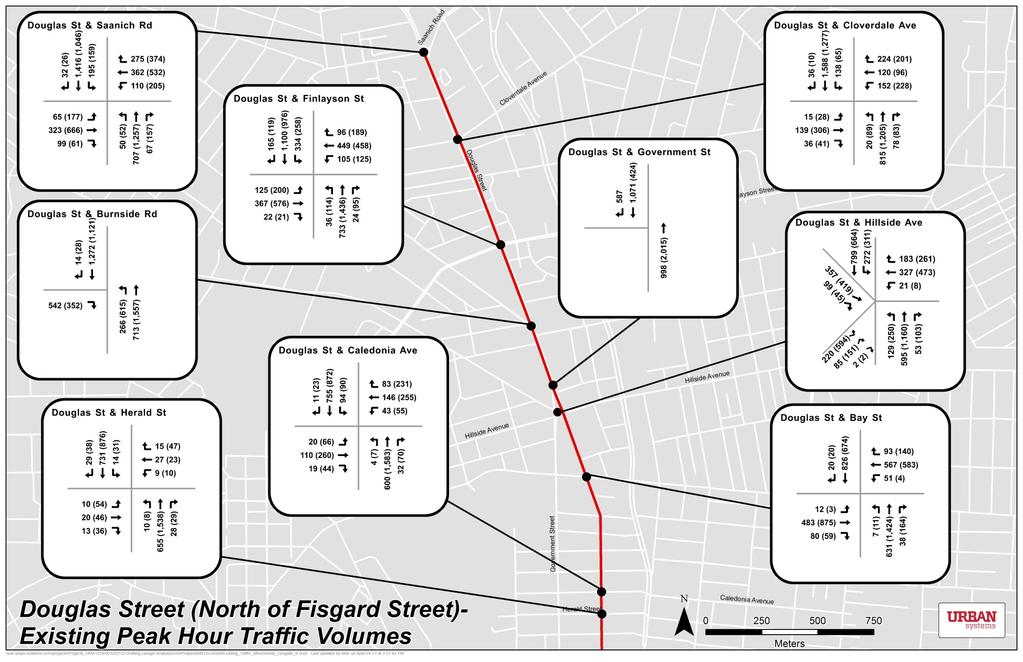
9 Page 7 Figure 2 Existing Douglas Corridor Left Turn Bans Douglas Street carries approximately 35,000 vehicles per day in the heaviest trafficked segment (near the Burnside Road intersection). South of Tolmie Avenue, the Douglas Street corridor supports anywhere from 700 to 1,700 peak direction vehicles per hour in two travel lanes per direction. South of Hillside, existing peak direction traffic volumes of less than 1,100 vehicles per hour could generally be accommodated in one travel lane per direction with moderate traffic diversions to Government or Blanshard Streets.


10 Page 8 Figure 3 Peak Directional Traffic and Bus Volumes along Douglas Street Peak Directional Traffic Volumes Today 2023 Douglas North Douglas Central Douglas South Peak Directional Bus Volumes Today 2023 Douglas North Douglas Central Douglas South BC Transit operates anywhere from five to sixteen routes along the corridor and accounts for less than 5% of all vehicles (see Figure 3 Peak Directional Traffic and Bus Volumes along Douglas Street). As shown in Figure 4, Douglas Street is the principle north-south corridor for transit in Victoria with a increasing number of routes operating along the corridor from the north to south. Most routes operating along the corridor are destined to the core area of Victoria from one of four key portals Highway 1, Highway 17 via Hillside Avenue, Saanich Road, and Johnson Street/Yates Street/Pandora Avenue. Most routes terminate or leave the corridor to the south at Belleville Street or just south of this intersection near Beacon Hill Park.


11 Page 9 Figure 4 Douglas Street Corridor Transit Services South of Hillside, BC Transit operates anywhere from 35 to 80 buses per hour in the peak direction during peak hours. With planned growth and the potential of transit priority lanes along Douglas Street, bus services are expected to increase to as many as 100 buses per hour during the peak within the next ten years. In order to deliver reliable and attractive transit for customers, transit priority treatments are generally required along corridors serving 25 to 30 buses per hour. Along more frequent corridors such as

12 Page 10 Douglas Street, transit only facilities queue jumps and bus only lanes are typically required to maintain and increase services as well as ridership. A majority of people traveling the corridor today are on transit. Today, the Douglas Street corridor serves anywhere from 2,500 to 3,000 people per hour in the peak direction. As shown in Figure 5 People Movement by Mode along Douglas Street, approximately two thirds of all people travelling through the southern segment are doing so on a bus while over one third of all people are on transit in the northern sections. In this regard, the people moving capacity of the corridor can only be enhanced through the provision of additional transit services along with transit priority treatments. Figure 5 People Movement by Mode along Douglas Street Most intersections south of Tolmie operate with moderate delays resulting in average peak period-peak direction vehicle travel speeds ranging from 15km/hr to 30km/hr. All intersections operate at levels of service D or better during the AM and PM peak periods except Hillside Avenue which operates at level of service E during the PM peak period. Figure 6 and Figure 7 below illustrate vehicle speeds for general purpose traffic along the Douglas Street corridor during the peak periods. Those noted areas of delay where vehicle speeds are less than 10-15km/hr affect reliability, travel time and the efficiency of transit and are principally located at the key signalized intersections. As travel demands grow, travel speeds will worsen for all modes if transit priority treatments are not implemented in the short-term. Appendix A summarizes the existing intersection volumes for the Douglas Street corridor.


 Travel")
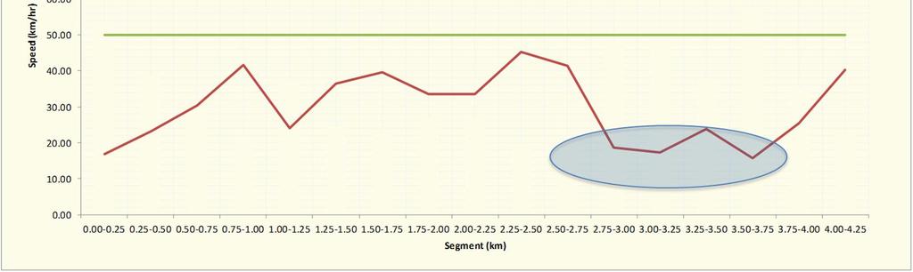
13 Page 11 Figure 6 PM Peak-Peak Direction (Northbound) Travel Speeds along Douglas Street Figure 7 AM Peak-Peak Direction (Southbound) Travel Speeds along Douglas Street

14 Page McKenzie Avenue (Highway 17 Finnerty Road) The McKenzie Avenue corridor is classified as a major road and truck route in the District of Saanich s Official Community (2008). McKenzie Avenue is the primary east-west link between Highways 1 and 17 and the University of Victoria. An interchange at Highway 17 is located at the western extent of the segment with Finnerty Road (UVic) as the eastern extent. The following discussion summarizes the physical and travel characteristics of the McKenzie Avenue corridor for the purpose of identifying and evaluating transit priority treatments. The McKenzie Avenue corridor supports two travel lanes in each direction from Highway 17 to McGill Road and one travel lane in each direction from McGill Road to Finnerty Road, with additional left turn lanes near major intersections. The segment has ten signalized intersections and carries approximately 25,000 vehicles per day in the heaviest trafficked segment (near the Borden Street intersection). The McKenzie Avenue corridor supports anywhere from 1,000 to 1,300 peak direction vehicles per hour in two travel lanes per direction. Two travel lanes per direction are required through most of the segment to accommodate existing and anticipated traffic demand. Figure 8 Peak Directional Traffic and Bus Volumes along McKenzie Avenue Peak Directional Traffic Volumes Today McKenzie West McKenzie East
 serving the McKenzie Avenue corridor increases from west to east towards UVic.")
15 Page 13 Peak Directional Bus Volumes Today McKenzie West McKenzie East BC Transit operates five routes along the corridor between Highway 17 and Shelbourne Street and six routes between Shelbourne Street and Finnerty Road. As shown in Figure 9, the number of bus routes (and total buses) serving the McKenzie Avenue corridor increases from west to east towards UVic. At the western end of the segment, bus routes connect with McKenzie Avenue from either Highway 17 or western McKenzie Avenue. Additional routes enter at Saanich Road, Quadra Street and Shelbourne Street. Most bus routes along the corridor terminate at or near UVic.

16 Page 14 Figure 9 Existing Transit Services on McKenzie Avenue BC Transit operates anywhere from 16 to 23 buses per hour in the peak direction during peak periods. With planned growth, this is expected to rise to as many as 32 buses per hour within the next 20 years. In order to deliver reliable and attractive transit for customers, transit priority treatments are generally required along corridors serving 25 to 30 buses per hour. A large share of people traveling the corridor today is on transit. Today, the McKenzie Avenue corridor serves almost 1,800 people in the peak direction during the AM or PM peak hours. As shown in Figure 10, approximately 25% of all people travelling the corridor during peak hours are on transit. In this regard, the people moving capacity of the corridor can be greatly enhanced through the provision of additional transit services along with transit priority treatments.

17 Page 15 Figure 10 People Movement by Mode along McKenzie Avenue Many intersections in particular, the Cedar Hill Road, Shelbourne Street and Quadra Street signals experience moderate delays during the peak periods. All intersections operate at LOS D or better during the AM and PM peak periods except Quadra Street which operates at LOS E during the AM and PM peak period, and Shelbourne Street which operates at LOS E during the PM peak period. Figure 11 PM Peak-Peak Direction (Westbound) Travel Speeds along McKenzie Avenue and Figure 12 below illustrate vehicle speeds for general purpose traffic along the McKenzie Avenue corridor during the peak periods. Those noted areas of delay affect reliability, travel time and the efficiency of transit and are principally located at the key signalized intersections. As travel demands grow, travel speeds will worsen for all modes if transit priority treatments are not implemented in the short-term. The slowest vehicle speeds are experienced at those intersections with the worst levels of service. Appendix A summarizes the peak intersection volumes for the McKenzie Avenue corridor.


 Travel")
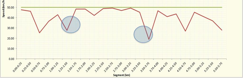
18 Page 16 Figure 11 PM Peak-Peak Direction (Westbound) Travel Speeds along McKenzie Avenue Figure 12 AM Peak-Peak Direction (Eastbound) Travel Speeds along McKenzie Avenue

19 Page Island Highway (Goldstream Avenue Highway 1) Island Highway is an arterial north-south roadway linking the western communities with Highway 1. The corridor was previously the old Trans-Canada Highway alignment. The study segment is located in Colwood and View Royal and is bounded by Goldstream Avenue in the south and Highway 1 at Colwood Interchange in the north. There are no parallel alternatives to Island Highway for through traffic. The following discussion summarizes the physical and travel characteristics of the Island Highway corridor for the purpose of identifying and evaluating transit priority treatments. The Island Highway corridor supports two travel lanes in each direction, with additional left turn lanes at intersections and several two-way left-turn lane segments. The segment has six signalized intersections and carries approximately 38,000 vehicles per day in the heaviest trafficked segment (near the Wale Road/Ocean Boulevard intersection.) The Island Highway corridor supports up to 2,300 vehicles per hour per direction. Two travel lanes per direction are required through the segment to accommodate existing and anticipated traffic demand Figure 13 Peak Directional Traffic and Bus Volumes along Island Highway Peak Directional Traffic Volumes Today Island Highway

20 Page 18 Peak Directional Bus Volumes Island Highway Today 2023 BC Transit operates seven routes along the corridor. The Island Highway corridor is the primary transit link between the western communities and Highway 1, which connects to Douglas Street and central Victoria. As shown in
21 Page 19 Figure 14, while most transit routes enter the segment at the southern extent along Sooke Road, an additional route joins at Goldstream Avenue. At the northern end of the segment, most routes funnel onto Highway 1 to connect to central Victoria. A significant regional transit exchange Western Exchange is located along the corridor at Ocean Boulevard.


22 Page 20 Figure 14 Existing Transit Services on Island Highway BC Transit operates twenty-four buses per hour in the peak direction during peak hours. With planned growth, this is expected to rise to as many as 34 buses per hour within the next 10 years. In order to deliver reliable and attractive transit for customers, transit priority treatments are generally required along corridors serving 25 to 30 buses per hour. A large share of people traveling the corridor today is on transit. Today, the Island Highway corridor carries approximately 2,600 to 3,200 people in the peak direction during the AM or PM peak hours. As shown in Figure 15, nearly 25% of all people travelling the corridor during peak hours are doing so on a bus.

23 Page 21 Figure 15 Peak Direction-Peak Hour People Movement by Mode along Island Highway Some intersections along the corridor experience moderate to heavy levels of delay during the peak periods. All intersections operate at levels of service D or better during the AM and PM peak periods except Goldstream Avenue and Six Mile Road which operate at level of service E during the PM peak period. Figure 16 and Figure 17 below illustrate vehicle speeds for general purpose traffic along the Island Highway corridor during the peak periods. Those noted areas of delay affect reliability, travel time and the efficiency of transit and are principally located at the key signalized intersections. As travel demands grow, travel speeds will worsen for all modes if transit priority treatments are not implemented in the short-term. The slowest vehicle speeds are experienced at those intersections with the worst levels of service. Appendix A summarizes the peak hour intersection volumes for the Island Highway corridor.


 Travel")

24 Page 22 Figure 16 PM Peak-Peak Direction (Southbound) Travel Speeds along Island Highway Figure 17 AM Peak-Peak Direction (Eastbound) Travel Speeds along Island Highway
25 Page Options Development Preliminary concepts were developed that sought to improve bus operations along the three corridors through transit-specific treatments, such as bus lanes or queue jumpers. This section outlines the framework for developing preliminary concepts and introduces the concepts shortlisted for each of the three corridors for further technical evaluation. 3.1 Strategies to Keep Transit Moving Improvements in speed and reliability make transit travel more competitive with automobile travel which contributes to attracting more passengers. Decreased bus running times due to transit priority measures leads to increased operating speed, which can result in fewer buses required to provide the same frequency of service on a given route. Alternately, the same number of buses could be used to provide more frequent service along travel corridors. In the ultimate case, significant travel time reductions allow transit to compete with auto travel and translate into increased transit ridership. To the extent that a high quality of transit service is maintained, employing transit priority measures in key corridors can help defer costs associated with higher-order transit projects. BC Transit employs a range of strategies to provide more attractive service levels and facilities in order to keep transit moving through areas of growing congestion and delay. Through service planning and design, ongoing improvements to the customer experience and efficiency of the system can be made through operational changes such as by simply increasing stop distance and managing boarding and alighting activities. In some cases where sufficient ridership and services are provided, more active measures that include a wide range of traffic signal based measures can be used (transit biased signal progression, provision of transit specific signal phases, and traffic signal phase modification based on transit needs (TSP)). In other corridors where service and ridership is significant and rapid transit services are envisioned, passive measures may be considered that include enhancements targeted at either all modes and that also result in transit improvements (i.e. widening of roadways); provision of exclusive transit operating space (bus ways, dedicated lanes, or queue jump bays); and regulatory exemptions (exemption from turn restrictions or other prohibitions). As illustrated below, the benefits of reallocating or providing additional space for buses on any of the corridors must be weighed against the impacts and with community engagement to build awareness of the trade-offs to keep transit moving.

26 Page 24 Figure 18 Example Transit Priority Improvements Range of potential infrastructure works At this time, BC Transit wants to consider opportunistic and larger scale transit priority treatments such as intersection queue jump lanes and/or bus only lanes along each of the three study corridors. As a first step to implement transit priority treatments along the study corridors, two principles have guided the identification and development of the alternatives as outlined below: Working within the existing ROW. The benefits of any transit priority treatments must exceed the costs over the appropriate period of time. The cost for acquiring land in addition to the capital cost to construct is neither a practical short-term strategy nor likely to result in an attractive benefitcost. In the case of McKenzie Avenue and Island Highway, the constrained rights-of-way and some recent changes minimize any significant widening for transit only lanes and intersection queue jumpers. Conversely, some widening of the Douglas Street corridor for a curb-side operating bus lane could generally be achieved within the existing right-of-way. Maintaining continuity with the long-term vision. Each of the corridors has been slated for rapid transit given the existing and growing travel demands. Light Rail Transit (LRT) is planned between the Western Communities and downtown Victoria operating along the Douglas Street and Island Highway corridors. In the long-term, rapid bus service and facilities are planned for the McKenzie Avenue corridor between Uptown and U-Vic. Although the specific alignment and configuration for LRT has not been determined, the Island Highway corridor is expected to retain four travel lanes to accommodate the highest peak traffic demands among the three corridors. In order to accommodate LRT, the Douglas
27 Page 25 Street corridor would retain four travel lanes in the north, and only two lanes south of Hillside Avenue. Example road cross-sections with potential LRT alignments derived from the Victoria Regional Rapid Transit Study are illustrated below for the purpose of considering long-term provision of travel lanes. BC Transit will continue to work with municipalities to preserve or increase rights-of-way through redevelopment and other property acquisition strategies. Figure 19 - Anticipated Travel Lanes Remaining with LRT (LRT Alignment Not Confirmed)
 along Douglas Street varies across the corridor between Tolmie Avenue and Humboldt Street.")

28 Page 26 The transit priority treatments considered for each corridor are highlighted in Figure 20. Figure 20 Transit Priority Treatments Considered for Each Corridor 3.2 Douglas Street Options The right-of-way (ROW) along Douglas Street varies across the corridor between Tolmie Avenue and Humboldt Street. In the northern sections of the corridor, the ROW width is generally in the range of 30.0m to 31.5m. South of Hillside Avenue, the ROW width is generally near 30.5m. While an additional travel lane can be generally accommodated in most of the corridor within the ROW, widening of the roadway to accommodate buses could not include provisions for bike lanes and wider sidewalks without property impacts. The three optional short-term bus priority treatments considered for Douglas Street between Tolmie Avenue and Humboldt Street/Burdett Avenue are designed to remain within the ROW as briefly described below. A. General Purpose (GP) Traffic Lane Conversion. During peak periods (6am to 9am and 3pm to 6pm), the existing right-side GP lanes would be converted to a bus only lane in both the northbound and southbound directions (see Figure 21 below). North of Finlayson, six lane cross-sections would be converted to four GP travel lanes and two bus only lanes during peak periods. South of Finlayson, the four travel lanes would be converted to two GP travel lanes and two bus only lanes during peak periods. Traffic signal priority systems already in place throughout much of the corridor would be complemented with further investments to equip buses with Automatic
29 Page 27 Vehicle Locators (AVL) communications that allow for bus detection and signal pre-emption to maintain attractive travel speeds and reliability. The existing Douglas Street corridor operation would remain unchanged during midday, evening and weekends. It should be noted that four GP lanes were identified in the long-term for Douglas Street north of Hillside when LRT is implemented. On-street parking would be retained along with bicycle facilities where they exist today. Property access would not be altered. Right-turn lanes would not be altered with the provision of a bus only lane and right-turn movements would be maintained throughout the corridor. In addition to the peak and all day left-turn restrictions that exist along the corridor today between Bay Street and Fort Street, further left-turn restrictions would be implemented during peak periods as illustrated in Figure 22. A new southbound left turn lane would be constructed at Fort Street to accommodate significant demand at this intersection. B. Additional Bus Only Lane. This optional concept includes retaining four GP lanes and two bus only lanes between Tolmie Avenue and Fisgard Street. Existing four lane sections of Douglas Street would be widened to add a bus only lane and GP lanes would be converted where there are six lane cross-sections north of Finlayson as illustrated in Figure 23. South of Fisgard, Douglas Street would remain as a four lane roadway and one GP lane in each direction would be converted to bus only facilities during the peak periods. Traffic signal priority systems already in place throughout much of the corridor would be complemented with further investments to equip buses with Automatic Vehicle Locators (AVL) communications that allow for bus detection and signal preemption to maintain attractive travel speeds and reliability. Similar to Concept A, a bus-only lane in the northbound and southbound directions would remain in operation for the peak periods (6am to 9am and 3pm to 6pm). During the peak periods, existing on-street parking would be restricted in both the northbound and southbound directions. Existing on-street bicycle lanes would be retained along Douglas Street between sections of Bay to Pembroke. In general, right-turn lanes that exist throughout the corridor would be modified to a shared bus and right-turn lane. Curb extensions that narrow the crossing of Douglas Street for pedestrians would be removed. Although the Douglas Street corridor would need to be widened in the long-term with the provision of LRT, four GP travel lanes are not envisioned south of Hillside.


30 Page 28 Figure 21 - Option A General Purpose Traffic Lane Conversion (Tolmie Ave to Burdett Ave)

31 Page 29 Figure 22 - Potential Left-turn Restrictions
32 Page 30 C. GP Traffic Lane Conversion and Additional Northbound Bus Lane North of Hillside. This concept is perhaps most aligned with the longterm vision in that four GP travel lanes are maintained north of Hillside and only two GP lanes in the south (see Figure 24). South of Hillside, this concept is similar to Concept A where right-side GP travel lanes are converted to bus only lanes during the peak periods (6am to 9am and 3pm to 6pm). North of Hillside, two GP lanes would be retained in both directions and a northbound bus only right-side lane would be added to the corridor through to Tolmie Avenue. The existing Douglas Street corridor operation would remain unchanged during midday, evening and weekends. On-street parking would be retained along with bicycle facilities where they exist today. Property access would not be altered and right-turn movements would be permitted. Right-turn lanes would be maintained with the provision of a bus only lane. In addition to the peak and all day left-turn restrictions that exist along the corridor today between Bay Street and Fort Street, additional left-turn restrictions would be implemented during peak periods as was illustrated in Figure 22.

33 Page 31 Figure 23 - Option B Additional Bus Lane (Tolmie Ave to Burdett Ave)
")
34 Page 32 Figure 24 - Option C Concept A (south of Hillside) & Northbound Bus Lane to North (Tolmie Ave to Burdett Ave)
35 Page McKenzie Avenue Concepts The McKenzie Avenue right-of-way (ROW) varies across the corridor between Highway 17 and Finnerty Road. In the eastern areas where McKenzie Avenue is being upgraded, the ROW width is approximately 30.5m to 39.5m. In the central and western sections of the corridor, the ROW will generally vary between 18m and 35m wide. For a bus only lane to be implemented in both directions in addition to maintaining four general purpose travel lanes, sidewalks and bike lanes, a ROW of more than 29m would be required through much of the corridor as conceptually illustrated below wider at intersections. The District of Saanich and BC Transit should work to confirm an ultimate cross-section for rapid transit and other facilities in order to secure property required as redevelopment occurs along McKenzie Avenue. Figure 25 - Potential Ultimate Cross-section for McKenzie Avenue Short-term concepts for the McKenzie Avenue corridor that fit within the ROW include intersection bus queue jumpers where the right-of-way is currently available and where peak period congestion levels contribute to delays for transit. The following discussion highlights the proposed concepts for the transit priority treatments at Quadra Street as well as between Cedar Hill Road and Shelbourne Street. A. Quadra Street Eastbound and Westbound Bus Queue Jumper. Eastbound and westbound queue jumpers are proposed at Quadra Street to allow buses to get ahead of traffic near this highly congested intersection (see Figure 26). Existing cross-sections would be widened near Quadra Street to accommodate the proposed queue jump lanes. The proposed eastbound bus queue jumper would start approximately 150m west of the Quadra Street intersection and merge with traffic on the west side after the existing bus bay. The eastbound queue jump lane

36 Page 34 would be shared with approximately right-turn vehicles during peak hours. The proposed westbound bus queue jump lane would start approximately 200m east of Quadra Street to connect with the existing bus bay. With the more than 280 right-turn vehicles during peak hours and high pedestrian activity levels, a separate westbound right-turn lane is also proposed. Figure 26 - Quadra Street Eastbound and Westbound Bus Queue Jumper Lanes B. Eastbound Bus Queue Jumper Cedar Hill Road to Shelbourne Street. An eastbound bus queue jumper lane is proposed along McKenzie Avenue from west of Cedar Hill Road through to the east side of Shelbourne Street (see C. D. Figure 27). While traffic congestion is heavy near this intersection in both directions of travel, a westbound queue jumper is not proposed due to significant property constraints through this segment. Existing crosssections would be widened through the segment to accommodate the proposed queue jump lane. The proposed eastbound queue jumper would be approximately 400m in length, starting approximately 170m west of Cedar Hill Road and continuing through both the Cedar Hill Road and Shelbourne Street intersections to the existing bus stop bay immediately east of Shelbourne Street. The eastbound queue jumper would be shared with right-turn vehicles that range anywhere from 65 to 125 vehicles per hour at both intersections. There is insufficient right-of-way at this time to acquire lands for a separate right-turn lane at the intersections.
 varies across the corridor between Goldstream Avenue and Highway 1. Overall, the ROW is approximately 25m")
37 Page 35 Figure 27 - Eastbound Bus Queue Jumper Lane Cedar Hill Road to Shelbourne Street 3.4 Island Highway Concepts The Island Highway right-of-way (ROW) varies across the corridor between Goldstream Avenue and Highway 1. Overall, the ROW is approximately 25m to 30.5m. For a bus only lane to be implemented in both directions in addition to maintaining four general purpose travel lanes, auxiliary two-way left turn lanes, sidewalks and bike lanes, a ROW of more than 32m would be required at much of the corridor. Shorter-term concepts for the Island Highway corridor include intersection bus queue jumpers where the right-of-way is currently available and where peak period congestion levels contribute to delays for transit. The following discussion highlights the proposed concepts for the transit priority treatments at Goldstream Avenue, Hart Road, and Colwood Interchange (Old Island Highway signal). A. Goldstream Avenue Northbound Transit Queue Jumper. A northbound transit queue jumper is proposed at Goldstream Avenue. As shown in B. Figure 28, two options are presented for this intersection. Both options involve converting the existing northbound right turn lane to a shared queue jumper/right turn lane. Option A involves a simple relocation of the right GP lane stop bar, allowing transit vehicles to get in front of northbound traffic queues before the Goldstream signal. No intersection reconfiguration or curb line alterations are required for Option A. Option B is a traditional intersection bus queue jump, where an additional bus queue jump lane is extended across the intersection. Option B involves extending the existing right turn lane southwards to begin at Jerome Road, approximately 170m south of Goldstream Avenue. Intersection and curb line modifications would be required for Option B.


.")

38 Page 36 Figure 28 - Goldstream Avenue Northbound Queue Jumper Lane Options A and B C. Hart Road Northbound Queue Jumper Lane. A northbound transit queue jumper is proposed near the Hart Road signal to allow transit vehicles to get ahead of significant northbound queues spilling back from the Six Mile signal. The proposed queue jumper lane ends before the Six Mile signal to avoid costly expansion of Parson s Bridge (see Figure 29). The approximately 300m northbound queue jump lane begins about 150m south of Hart Road, continues through the intersection and terminates about 100m south of Six Mile Road, on the Parson s Bridge. The northbound queue jump lane would be shared with northbound right turning vehicles to Hart Road. Figure 29 - Hart Road Northbound Queue Jumper Lane
39 Page 37


40 Page Option Evaluation & Recommendations 4.1 Evaluation Framework A high level evaluation framework is used to highlight and compare the qualitative and quantitative costs, impacts and benefits of each concept described in Section 3 of the technical report. At this level, the evaluation framework is really intended highlight the benefits and impacts and to provide stakeholders with a comparative evaluation of the bus priority treatments. The four accounts examined within this review along with related measures are briefly described and illustrated below. Figure 30 - Evaluation Framework Transport account considers the impacts and benefits of a proposed concept on the transportation system that include, but are not limited to the transit system, traffic circulation and conditions, bicycle and pedestrian facilities as well as parking where applicable. The specific measures and assumptions are briefly summarized below: o Transit travel time and speed changes are forecast based on current corridor conditions established through GPS surveys in cars as well as on buses travelling each corridor, in addition to an analysis of changing corridor conditions using microsimulation models of intersections.
41 Page 39 o Traffic diversion impacts to accommodate general purpose lane conversions on Douglas Street during peak periods are forecast using the regional transportation model. o Impacts of left-turn restriction at intersections without left-turn lanes where identified on Douglas Street are evaluated based on existing turning movement patterns. o Potential impacts on other modes and parking are identified based on the potential changes to the corridor cross-section and configuration. Environment account highlights any anticipated impacts on environmental areas and landscaping along the corridor (such as trees) as well as the relative differences in GHG emissions by buses between concepts and overall transit ridership. Social account includes any differences on property impacts, driveway access or visual character of the corridor. Economic account represents a financial account highlighting the overall monetary benefits and costs of each concept. The following assumptions are used to calculate individual measures contributing to the financial account: o The capital costs for each concept are also highlighted based on a conceptual level of detail (Class D). This level of cost estimating is typically used to compare options and not for budgeting purposes. o Travel time savings applied to transit customers based on a $10/hour value of time. o Operating cost savings from travel time reductions are estimated based on a $99/hour value of time for the operator. o The economic evaluation has been prepared for a 10 year horizon along Douglas Street and Island Highway as interim treatments and 20 years along McKenzie Avenue as a longer term strategy for bus rapid transit. It should be noted that a shorter or longer term evaluation would simply shift the net present value and B/C ration up or down respectively. o A discount rate of 6% is used for the purpose of the economic analysis.

42 Page Douglas Street While the benefits to transit and relationship to the environmental account are generally very similar for all three Douglas Street corridor concepts, they have very different impacts on other transport and economic metrics. The following discussion highlights the assessment of each concept and their comparative review. i. Transport The transport account is summarized for each of the Douglas Street concepts in Table 1. In general, bus travel time benefits for the customer and operator are very similar for all three concepts. Without a southbound bus only lane north of Hillside Avenue, Concept C will have slightly lower overall travel time reductions through this segment. The proposed reduction of GP travel lanes in Concept A will divert almost 50% of the traffic using the Douglas Street corridor to parallel north-south routes such as Government Street and Blanshard Street in particular. The regional transportation model was used to project an increase of approximately 200 to 300 vehicles per peak hour along several parallel corridors (a 10-20% increase in traffic volumes). While a 20% increase along these parallel routes will increase delays at a few intersections along Blanshard Street north of Bay Street, as illustrated below in Figure 31 (from LOS D/E to LOS F), in general, sufficient capacity exists along parallel routes to accommodate increases of this magnitude.
43 Page 41 Table 1 - Douglas Street Transportation Account Summary CONCEPT A GP Lane Conversion Up to as much as 4 minutes per bus CONCEPT B Additional Bus Lane Up to as much as 4 minutes per bus CONCEPT C NB Only Bus Lane (north) + GP Lane Conversion (South) Up to as much as 4 minutes per bus in NB direction only Reduces capacity for GP traffic Left turn restrictions impacts circulation No impacts on GP traffic Curb extension removal impacts pedestrian crossing times Reduces capacity for GP traffic south of Hillside Left turn restrictions impacts circulation Significant traffic diversion of approximately 50% of traffic to other corridors increase travel time by as much as 5 minutes Removal of on-street parking during peak periods Approximately 25% of traffic south of Hillside diverted to parallel routes increasing travel time by as much as 2.5 minutes Corridor operation is moderate-good (LOS D or better) May consider right-turn restrictions Corridor operation is moderate-good (LOS D or better) No impact on existing pedestrian crossings or buffers No impact on existing pedestrian crossings or buffers No impacts on bike lanes or on-street parking No impacts on bike lanes or on-street parking


44 Page 42 Figure 31 - Existing and Project Intersection Levels of Service Existing Base +20% Additional Traffic Concept B will not divert any traffic to parallel corridors and Concept C will divert traffic south of Hillside where the extent and impacts are considered to be more moderate. Once again, it is generally expected that Douglas Street would be reduced to two GP travel lanes south of Hillside with the implementation of LRT. Existing bicycle and pedestrian facilities would not be impacted with Concept A and C. The additional northbound and southbound bus only lanes in Concept B will result in wider crossings for pedestrians at intersections that are currently equipped with curb extensions throughout much of the downtown and a general narrowing of sidewalks between Hillside and Fisgard.
45 Page 43 Right-side bus only lanes in all concepts will not impact vehicle access and egress to adjacent properties. However, Concept A will require additional left-turn restrictions at some intersections during peak periods with a single GP lane in either direction. ii. Social/Property The social/property account is summarized for each of the Douglas Street concepts in Table 2. Concept A involves no impacts on the corridor and requires pavement markings and signage only. All curbs and curb extensions, lighting, hydro and signage remain in place in Concept A with the exception of the area immediately surrounding the Fort Street intersection (where a new southbound left turn lane is proposed). Concept B involves the widening of the existing roadway to allow for two new lanes in most segments between Tolmie Avenue and Fisgard Street. South of Fisgard Street, Concept B repurposes two of the existing GP lanes as peak-period transit lanes, as in Concept A. Widening the roadway requires the relocation of hydro, light standards, and intersection signal masts and will result in the removal of curb extensions and the narrowing of sidewalks. Concept C requires widening on the east side only between Hillside and Tolmie to provide for a new northbound bus only lane. South of Hillside, Concept C repurposes existing GP lanes as peak-period transit-only lanes, as in Concept A. No private property takings are required for any of the three options. All concepts are generally consistent with long-range community and corridor plans. Table 2 - Douglas Street Social/Property Account Summary CONCEPT A GP Lane Conversion No physical impacts on the corridor Requires pavement markings Consistency with community plans CONCEPT B Additional Bus Lane Widening of road on east and west sides by 1 lane Hydro, light standard, and intersection signal relocation Consistency with community plans CONCEPT C NB Only Bus Lane (north) + GP Lane Conversion (South) Requires widening on east side north of Hillside Avenue Requires pavement markings south of Hillside Avenue Consistency with community plans
46 Page 44 iii. Environment The environmental account is summarized for each of the Douglas Street concepts in Table 3. As Concept A is expected to result in moderate vehicle rerouting and correspondingly, moderate increases in delay on Blanshard Street north of Bay Street, it is anticipated that this concept will result in a modest increase of GHGs for GP traffic. In Concept C, GP lane conversions during the peak would occur south of Hillside only, resulting in moderate traffic diversions and delays as compared with Concept A, and correspondingly lesser increases of GHGs for GP traffic. Concept B does not result in vehicle rerouting and will not result in increased GHGs for GP traffic from the base condition. The widening for the bus only lanes in Concept B will require the removal of trees north of Fisgard Street. All concepts will result in reduced GHG emissions for buses, as they all reduce peak period bus idling and are expected to increase ridership and minimizing growth in vehicle travel. Table 3 - Douglas Street Environment Account Summary CONCEPT A GP Lane Conversion No impacts on environmental areas Modest increase in GHGs for GP traffic Reduced GHG from buses and increased ridership CONCEPT B Additional Bus Lane No impacts on environmental areas Removal of trees north of Fisgard Reduced GHG from buses and increased ridership CONCEPT C NB Only Bus Lane (north) + GP Lane Conversion (South) No impacts on environmental areas Reduced GHGs from buses and increased ridership iv. Economic The economic account is summarized for each of the Douglas Street concepts in Table 4. All concepts assessed exhibit good returns on investments as measured by the net present value and benefit-cost ratio. The impacts on diverted auto trips in Concept A reduces the overall benefits achieved by transit, but still results in a positive NPV and B/C above 1.0. Although Concept C results in some traffic diversion south of Hillside and increased travel time for auto trips, the impacts are significantly less while providing similar transit benefits.
47 Page 45 Table 4 - Douglas Street Economic Account Summary CONCEPT A CONCEPT B CONCEPT C Cost Capital Cost (PV) Maintenance & Rehab Costs (PV) Salvage Value Savings Transit Travel Time Savings (PV) Transit Operating Savings (PV) Auto Travel Time Savings (PV) Auto Operating Savings (PV) Summary $0.38M - $0.07M $15.3M $5.4M -$14.6M -$0.7M $5.90M $0.27M $1.20M $15.3M $5.4M - - $1.1M $0.05M $0.20M $15.2M $5.4M -$2.3M -$0.1M Net Present Value B/C Ratio $5.2M 18.5 $15.7M 4.1 $17.3M McKenzie Avenue The evaluation of the two transit priority treatments considered for the McKenzie Avenue corridor is briefly summarized below. Unlike the Douglas Street corridor evaluation, these concepts are not intended to be viewed as alternatives. The following discussion highlights the assessment of both concept and their comparative review. i. Transport The transport account is summarized for both of the McKenzie Avenue concepts in Table 5. With the significant travel delays at the Quadra Street intersections, eastbound and westbound bus queue jumpers are projected to result in savings of up to 1.5 minutes per bus. Between Cedar Hill and Shelbourne Street, bus travel time savings are slightly more modest with approximately 0.6 minutes per bus. Overall, these transit priority treatments do not affect the delays already experienced at each intersection. Proposed bus queue jumper lanes carry through all intersections and do not require additional signal phases. However, both concepts will result in increased walk times for pedestrian across McKenzie Avenue as the additional bus queue jump lanes increases crossing distance.
48 Page 46 Table 5 - McKenzie Avenue Transportation Account Summary ii. CONCEPT 1 Quadra EB and WB Queue Jumper Up to 1.5 minutes of time savings per bus Limited impacts on intersection operation Increased pedestrian crossing time due to widening Social/Property CONCEPT 2 Cedar Hill Shelbourne EB Queue Jumper Up to 0.6 minutes of time savings per bus Limited impacts on intersection operation Increased pedestrian crossing time due to widening The social/property account is summarized for both of the McKenzie Avenue concepts in Table 6. No private property impacts are anticipated for either of the concepts, however utilities, light standards and signal masts will need to be relocated. Additionally, both concepts will involve sidewalk relocations and for Concept 1, the removal of the north side boulevard at Quadra Street. Table 6 - McKenzie Avenue Social/Community Account Summary CONCEPT 1 Quadra EB and WB Queue Jumper Removal of north side boulevard Sidewalk relocations Utility, light standard, and signal mast relocations CONCEPT 2 Cedar Hill Shelbourne EB Queue Jumper Sidewalk relocations Utility, light standard, and signal relocations iii. Environment The environmental account is summarized for both McKenzie Avenue concepts in Table 7. These bus priority treatments will not impact environmental areas, and have marginal reductions in GHG emissions for buses.
49 Page 47 Table 7 - McKenzie Avenue Environment Account Summary CONCEPT 1 Quadra EB and WB Queue Jumper No localized impacts anticipated Modest GHG reduction from buses CONCEPT 2 Cedar Hill Shelbourne EB Queue Jumper No localized impacts anticipated Modest GHG reduction from buses iv. Economic The economic account is summarized for both the McKenzie Avenue concepts in Table 8. Concept 1 provides positive net present values and a benefit-cost ratio of 1.7, while the benefit-cost ratio of Concept 2 is below 1.0. Table 8 - McKenzie Avenue Economic Account Summary Cost Capital Cost (PV) Maintenance & Rehab Costs (PV) Salvage Value Savings Transit Travel Time Savings (PV) Transit Operating Savings (PV) Summary Net Present Value B/C Ratio CONCEPT 1 Quadra EB and WB Queue Jumper $1.30M $0.04M $0.27M $1.4M $0.5M $0.8M 1.7 CONCEPT 2 Cedar Hill Shelbourne EB Queue Jumper $1.40M $0.03M $0.28M $0.6M $0.27M -$0.3M Island Highway A set of spot-specific conceptual improvements have been prepared for Island Highway. Unlike what was prepared for the Douglas Street corridor, in most cases, a singular concept was developed for key problem segments along the corridor. As a result, concepts are not intended to be viewed as alternatives. The following discussion highlights the assessment of each concept and their comparative review.
50 Page 48 i. Transport The transport account is summarized for each of the Island Highway concepts in Table 9. In general, bus travel time benefits are very modest for all three improvements, with queue jumpers resulting in about minutes of travel time savings per bus at Goldstream and Colwood Interchange and 0.9 minutes near Hart Road-Six Mile. Improvements by and large do not repurpose existing general purpose lane space and are proposed to be mainly constructed in new lane space. All concepts, save concept 1A, increase pedestrian crossing time across Island Highway as an additional queue jump lane increases crossing distance. Additionally, expanding the Hart Road queue jumper (concept 2) onto the Parson s Bridge may result in the narrowing of the northbound cycle lane. All improvements are targeted to decrease transit delays in the AM peak period where traffic flow is predominantly northbound along Island Highway towards Highway 1. Table 9 - Island Highway Transportation Account Summary CONCEPT 1A & B Goldstream NB Queue Jumper Up to 0.4 minutes of time savings per bus Marginal impact on vehicle delays Increased pedestrian crossing time in Concept 1B CONCEPT 2 Six Mile NB Queue Jumper Up to 0.9 minutes of time savings per bus No impacts on GP traffic Increased pedestrian crossing time; potential narrowing of NB cycling facility over Parson s Bridge ii. Social/Property The social/property account is summarized for each of the Island Highway concepts in Table 10. No private property takings are required for any of the three concepts. All concepts are to occur in new lane space which will require the relocation of utilities, light standards, and signal masts. Concept 2 will involve shifting the road westwards through a segment that was recently rehabilitated. The removal and relocation of quadrant islands is required for all but concept 1A. All concepts are in line with long-range plans for the corridor.
51 Page 49 Table 10 - Island Highway Social/Community Account Summary iii. CONCEPT 1A & B Goldstream NB Queue Jumper No property impacts Potential removal of quadrant island (Concept B) Utility and signal relocations Environment CONCEPT 2 Six Mile NB Queue Jumper No property impacts Removal of quadrant island Utility and signal relocations The environmental account is summarized for each of the Island Highway concepts in Table 11. All concepts are not expected to impact environmental areas. All concepts will result in reduced GHG emissions for buses, as they all reduce peak period bus idling and are likely to increase ridership, which should result in fewer vehicles on the road. No increases in vehicle idling are anticipated. Table 11 - Island Highway Environment Account Summary CONCEPT 1A & B Goldstream NB Queue Jumper No impacts on environmental areas Modest GHG reduction from buses CONCEPT 2 Six Mile NB Queue Jumper No impacts on environmental areas Modest GHG reduction from buses iv. Economic The economic account is summarized for each of the Island Highway concepts in Table 12. Only Concept 1A exhibits a benefit-cost ratio over 1 at 2.8, with a net present value of $0.02 M. Concepts 1B and 2 exhibit benefit-cost ratios below 1.0 and negative net present values. Modest returns on investments are derived from the fact that improvements are largely proposed to be built in new lane space and the transit benefits are not significant.
52 Page 50 Table 12 - Island Highway Economic Account Summary Cost Capital Cost (PV) Maintenance & Rehab Costs (PV) Salvage Value Savings Transit Travel Time Savings (PV) Transit Operating Savings (PV) CONCEPT 1A & B Goldstream NB Queue Jumper $0.01M - $0.002M $0.02M $0.01M $0.86M - $0.17M $0.04M $0.02M CONCEPT 2 Six Mile NB Queue Jumper $1.6M $0.01M $0.32M $0.45M $0.15M Summary Net Present Value B/C Ratio $0.02M 2.8 -$0.63M 0.1 -$0.66M 0.5

53 Page Summary BC Transit commissioned Urban Systems to examine short-term transit priority improvement options along the Douglas Street, McKenzie Avenue and Island Highway corridors. The is designed to develop cost-effective short-term infrastructure strategies for the Douglas Street, McKenzie Avenue, and Island Highway corridors in order to enhance transit services, performance and customer experience as well as support increased ridership growth. While local, regional and provincial agencies have been engaged throughout the process, the recommended transit priority improvements have been shared with public stakeholders for further input and guidance. The development of a preferred short-term plan for each of the corridors occurred in four stages. The first two stages essentially included a review of background, current and future conditions along each of the three corridors in an effort to highlight the challenges for transit. The third stage of the process included the technical development and evaluation of feasible transit priority options that may be considered along the corridors. A shortlist of improvements and options were identified and evaluated for each of the corridors and discussed with municipal representatives. Following the technical evaluation of optional concepts, BC Transit presented all corridor options to local area Councils and the general public during the open houses on the Transit Future Bus held between June 5 th and 10 th as well as through on-line surveys. A summary of the improvement strategies and evaluation are briefly highlighted below.
54 Page 52 Douglas Street Summary The three optional short-term bus priority treatments considered for Douglas Street between Tolmie Avenue and Humboldt Street/Burdett Avenue are designed to remain within the ROW as briefly described below. A. General Purpose (GP) Traffic Lane Conversion. During peak periods (6am to 9am and 3pm to 6pm), the existing right-side GP lanes would be converted to a bus only lane in both the northbound and southbound directions. B. Additional Bus Only Lane. This optional concept includes retaining four GP lanes and two bus only lanes between Tolmie Avenue and Fisgard Street. Existing four lane sections of Douglas Street would be widened to add a bus only lane and GP lanes would be converted where there are six lane cross-sections north of Finlayson. South of Fisgard, Douglas Street would remain as a four lane roadway and one GP lane in each direction would be converted to bus only facilities during the peak periods. C. GP Traffic Lane Conversion and Additional Northbound Bus Lane North of Hillside. This concept is perhaps most aligned with the longterm vision in that four GP travel lanes are maintained north of Hillside and only two GP lanes in the south. A summary of the technical evaluation for the Douglas Street corridor options is provided in Table 13 below. McKenzie Avenue Summary Short-term concepts for the McKenzie Avenue corridor that fit within the ROW include intersection bus queue jumpers where the right-of-way is currently available and where peak period congestion levels contribute to delays for transit. The following discussion highlights the proposed concepts for the transit priority treatments at Quadra Street as well as between Cedar Hill Road and Shelbourne Street. A. Quadra Street Eastbound and Westbound Bus Queue Jumper. Eastbound and westbound queue jumpers are proposed at Quadra Street to allow buses to get ahead of traffic near this highly congested intersection.
55 Page 53 Table 13 - Douglas Street Evaluation Summary CONCEPT A GP Lane Conversion Up to as much as 4 minutes per bus Reduces capacity for GP traffic Approximately 50% of traffic diverted to other corridors Left turn restrictions impacts circulation Corridor operation is moderate-good (LOS D or better) No impact on existing pedestrian crossings or buffers No impacts on bike lanes or on-street parking CONCEPT B Additional Bus Lane TRANSPORTATION Up to as much as 4 minutes per bus No impacts on GP traffic Curb extension removal impacts pedestrian crossing times Removal of on-street parking during peak periods May consider right-turn restrictions CONCEPT C NB Only Bus Lane (north) + GP Lane Conversion (South) Up to as much as 4 minutes per bus in NB direction only Reduces capacity for GP traffic south of Hillside Approximately 25% of traffic south of Hillside diverted to parallel routes Left turn restrictions impacts circulation Corridor operation is moderate-good (LOS D or better) No impact on existing pedestrian crossings or buffers No impact on existing pedestrian crossings or buffers PROPERTY / SOCIAL No physical impacts on the corridor Requires pavement markings Consistency with community plans Widening of road on east and west sides by 1 lane Hydro, light standard, and intersection signal relocation Consistency with community plans Requires widening on east side north of Hillside Avenue Requires pavement markings south of Hillside Avenue Consistency with community plans ENVIRONMENTAL No impacts on environmental areas No impacts on environmental areas No impacts on environmental areas Modest increase in GHGs for GP traffic Removal of trees north of Fisgard Reduced GHGs from buses and increased ridership Reduced GHG from buses and increased ridership Reduced GHG from buses and increased ridership ECONOMIC NPV $5.2M B/C 18.5 $15.7M 4.1 $17.3M 19.1
56 Page 54 B. Eastbound Bus Queue Jumper Cedar Hill Road to Shelbourne Street. An eastbound bus queue jumper lane is proposed along McKenzie Avenue from west of Cedar Hill Road through to the east side of Shelbourne Street. A summary of the technical evaluation for the McKenzie Avenue corridor transit priority treatments is provided in Table 14 below. Table 113 McKenzie Avenue Evaluation Summary CONCEPT 2 CONCEPT 1 Cedar Hill Shelbourne EB Quadra EB and WB Queue Jumper Queue Jumper TRANSPORTATION Up to 1.5 minutes of time savings per bus Limited impacts on intersection operation Increased pedestrian crossing time due to widening Removal of north side boulevard Sidewalk relocations Utility, light standard, and signal mast relocations No localized impacts anticipated Modest GHG reduction from buses PROPERTY / SOCIAL ENVIRONMENTAL ECONOMIC Up to 0.6 minutes of time savings per bus Limited impacts on intersection operation Increased pedestrian crossing time due to widening Sidewalk relocations Utility, light standard, and signal relocations No localized impacts anticipated Modest GHG reduction from buses NPV $0.8M B/C 1.7 -$0.3M 0.7 Island Highway Summary Shorter-term concepts for the Island Highway corridor include intersection bus queue jumpers where the right-of-way is currently available and where peak period congestion levels contribute to delays for transit. The following discussion highlights the proposed concepts for the transit priority treatments at Goldstream Avenue, Hart Road, and Colwood Interchange (Old Island Highway signal). A. Goldstream Avenue Northbound Transit Queue Jumper. A northbound transit queue jumper is proposed at Goldstream Avenue. The two options are presented for this intersection involve converting the existing northbound right turn lane to a shared queue jumper/right turn lane. Option A involves a simple relocation of the right GP lane stop bar, allowing transit vehicles to
57 Page 55 get in front of northbound traffic queues before the Goldstream signal. Option B is a traditional intersection bus queue jump, where an additional bus queue jump lane is extended across the intersection. B. Hart Road Northbound Queue Jumper Lane. A northbound transit queue jumper is proposed near the Hart Road signal to allow transit vehicles to get ahead of significant northbound queues spilling back from the Six Mile signal. The proposed queue jumper lane ends before the Six Mile signal to avoid costly expansion of Parson s Bridge. C. Colwood Interchange (Old Island Highway signal) Northbound Queue Jumper Lane. A northbound transit queue jumper lane is proposed near the Old Island Highway signal at Colwood Interchange to allow transit vehicles to get ahead of northbound queues spilling back from the signal and improve transit connections onto the Trans-Canada Highway. A summary of the technical evaluation for the Island Highway transit priority treatments is provided in Table 15 below. Table 15 - Douglas Street Evaluation Summary CONCEPT 1A & B CONCEPT 2 Goldstream NB Queue Jumper Six Mile NB Queue Jumper TRANSPORTATION Up to 0.4 minutes of time savings per bus Marginal impact on vehicle delays Increased pedestrian crossing time in Concept 1B No property impacts Potential removal of quadrant island (Concept B) Utility and signal relocations No impacts on environmental areas Modest GHG reduction from buses NPV $0.015M B/C 2.8 -$0.63M 0.1 PROPERTY / SOCIAL ENVIRONMENTAL ECONOMIC Up to 0.9 minutes of time savings per bus No impacts on GP traffic Increased pedestrian crossing time; potential narrowing of NB cycling facility over Parson s Bridge No property impacts Removal of quadrant island Utility and signal relocations No impacts on environmental areas Modest GHG reduction from buses -$0.66M 0.5
58 Page 56 APPENDIX A EXISTING AM & PM PEAK HOUR TRAFFIC VOLUMES
59 DRAFT

60 T AF R D AM (PM) Peak Hour Volumes

61 T AF R D AM (PM) Peak Hour Volumes

62 T AF R D AM (PM) Peak Hour Volumes
Operational Comparison of Transit Signal Priority Strategies
 Operational Comparison of Transit Signal Priority Strategies Revision Submitted on: November, 0 Author: Adriana Rodriguez, E.I Assistant Engineer Parsons Brinckerhoff 0 South Orange Avenue, Suite 00 Orlando,
Main-McVay Transit Study: Phase 2 Options Definition and High Level Constraints Evaluation
 Main-McVay Transit Study: Phase 2 Options Definition and High Level Constraints Evaluation APRIL 2016 A collaborative study between: For Additional Information or to Comment If you would like additional
Corporate. Report COUNCIL DATE: June 26, 2006 NO: C012 COUNCIL-IN-COMMITTEE. TO: Mayor & Council DATE: June 22, 2006
 Corporate NO: C012 Report COUNCIL DATE: June 26, 2006 COUNCIL-IN-COMMITTEE TO: Mayor & Council DATE: June 22, 2006 FROM: General Manager, Engineering FILE: 0410-20(MoT/Gate) SUBJECT: Surrey Response on
APPENDIX 2 LAKESHORE ROAD TRANSPORTATION REVIEW STUDY EXECUTIVE SUMMARY
 APPENDIX 2 LAKESHORE ROAD TRANSPORTATION REVIEW STUDY EXECUTIVE SUMMARY Appendix 2 City of Mississauga Lakeshore Road FINAL REPORT Transportation Review Study December 2010 EXECUTIVE SUMMARY Study Purpose
Purpose and Need. Chapter Introduction. 2.2 Project Purpose and Need Project Purpose Project Need
 Chapter 2 Purpose and Need 2.1 Introduction The El Camino Real Bus Rapid Transit (BRT) Project (Project) would make transit and other transportation improvements along a 17.6-mile segment of the El Camino
University Hill Transportation Study Technical Memorandum Alternatives Modeling and Analysis May 2007
 Technical Memorandum May 2007 Syracuse Metropolitan Transportation Council Edwards and Kelcey with Wallace Roberts and Todd Alta Planning and Design CONTENTS SECTION ONE- INTRODUCTION...1 SECTION TWO-
5.0 Roadway System Plan
 Southwest Boise Transportation Study Page 16 5.0 Roadway System Plan The Roadway System Plan outlines roadway improvements in the Initial Study Area. It forecasts future deficiencies on the arterial system,
VOLUME 5 Technology and Option Evaluation
 VICTORIA REGIONAL RAPID TRANSIT Victoria / West Shore Link VOLUME 5 Technology and Option Evaluation August 2011 Prepared for BC Transit by SNC-Lavalin Inc McElhanney Consulting Services Ltd Errata 1.
Arterial Transitway Corridors Study. Ave
 Arterial Transitway Corridors Study Ave January 2012 Arterial Transitway Corridors Study Overview Corridor Features and Demographics 11 study corridors, 95 route miles 86,000 daily rides and half of existing
Roadways. Roadways III.
 Introduction 97 Roadway Design Principles 98 Safe Speeds 99 Optimizing of Street Space 00 Minimum Lane Widths in the City of Boston 02 Design Features that Reduce Operating Speeds 05 Travel Lanes Transit
Welcome. If you have any questions or comments on the project, please contact:
 Welcome This drop-in public open house is intended to provide information about the Bay Street bike lanes project. This project proposes a dedicated cycling facility along Bay Street between Aberdeen Avenue
DUNBOW ROAD FUNCTIONAL PLANNING
 DUNBOW ROAD FUNCTIONAL PLANNING Final Report August 3, 216 #31, 316 5th Avenue NE Calgary, AB T2A 6K4 Phone: 43.273.91 Fax: 43.273.344 wattconsultinggroup.com Dunbow Road Functional Planning Final Report
Having held a public hearing, that Council approve:
 3. MODIFICATIONS TO MERIVALE ROAD FROM FALLOWFIELD ROAD TO OLD HIGHWAY 16 TO ACCOMMODATE THE GROWTH WITHIN THE SOUTH MERIVALE BUSINESS PARK - PUBLIC HEARING COMMITTEE RECOMMENDATIONS Having held a public
Southwest Bus Rapid Transit (SW BRT) Functional Planning Study - Executive Summary January 19 LPT ATTACHMENT 2.
 Functional Planning Study - Executive Summary January 19 LPT ATTACHMENT 2.") Southwest Bus Rapid Transit (SW BRT) Functional Planning Study - Executive Summary 2011 January 19 1 of 19 Introduction This executive summary presents the results of the Southwest Bus Rapid Transit (SW
Southwest Bus Rapid Transit (SW BRT) Functional Planning Study - Executive Summary 2011 January 19 1 of 19 Introduction This executive summary presents the results of the Southwest Bus Rapid Transit (SW
Providence Downtown Transit Connector STAKEHOLDER MEETING #2. Stakeholder Meeting #1 October 24, 2016
 Providence Downtown Transit Connector STAKEHOLDER MEETING #2 Stakeholder Meeting #1 October 24, 2016 February 2017 1 AGENDA 1 DTC Goals and Expectations 2 Street Design Concepts 3 Potential Benefits and
McKenzie Interchange Project Fall 2015 Engagement. Appendix 2: Engagement Materials and Feedback Form
 Fall 2015 Engagement Appendix 2: Engagement Materials and Feedback Form Welcome to the McKenzie Interchange Project Open House! Purpose of Open House To provide you with information regarding the project
Chapter 3 BUS IMPROVEMENT CONCEPTS
 Chapter 3 BUS IMPROVEMENT CONCEPTS The purpose of this chapter is to describe potential bus improvement strategies and potential impacts or implications associated with BRT implementation within the existing
In station areas, new pedestrian links can increase network connectivity and provide direct access to stations.
 The Last Mile Planning for Pedestrians Planning around stations will put pedestrians first. Making walking to stations safe and easy is important; walking will be a part of every rapid transit Accessible
Dr. M.L. King, Jr. Street North Complete Streets Resurfacing Opportunities HOUSING, LAND USE, AND TRANSPORTATION COMMITTEE MARCH 22, 2018
 Dr. M.L. King, Jr. Street North Complete Streets Resurfacing Opportunities HOUSING, LAND USE, AND TRANSPORTATION COMMITTEE MARCH 22, 2018 What s Happening The City plans to mill and resurface Dr. M.L.
4. ENVIRONMENTAL IMPACT ANALYSIS 9. TRANSPORTATION AND TRAFFIC
 4. ENVIRONMENTAL IMPACT ANALYSIS 9. TRANSPORTATION AND TRAFFIC 4.9.1 INTRODUCTION The following section addresses the Proposed Project s impact on transportation and traffic based on the Traffic Study
Executive Summary Route 30 Corridor Master Plan
 Route Corridor Master Plan Project Overview The Route Corridor Master Plan is a coordinated multimodal transportation and land use plan for the entire stretch of Route through East Whiteland Township,
Active Transportation Infrastructure Investment A Business Case
 Active Transportation Infrastructure Investment A Business Case In 2016, the Real Estate Foundation awarded the Capital Regional District a $50,000 grant for Shifting Gears: Land Use Change through Active
WHITE PAPER: TRANSIT SERVICE FOR SOUTH SHAGANAPPI
 9/27/2012 TRANSIT PLANNING WHITE PAPER: TRANSIT SERVICE FOR SOUTH SHAGANAPPI 2012 Calgary Transit 1 Table of Contents Purpose... 3 Area of Change... 3 Background... 3 Access to destinations... 5 Connecting
WEST AND SOUTH WEST RING ROAD DOWNSTREAM TRAFFIC IMPACTS
 Page 1 of 9 EXECUTIVE SUMMARY Alberta Transportation ( AT ) is preparing to construct the final sections of the Calgary Ring Road. This includes the South West Ring Road ( SWRR ) (from Lott Creek Blvd
Chapter 5 Future Transportation
 Chapter 5 Future Transportation The Future Land Use Plan identifies the desired land use designations. The land uses desired for Crozet depend, in large part, on the success of the transportation system,
Terwillegar Drive Expressway Draft Concept Plan
 Terwillegar Drive Expressway Draft Concept Plan Anthony Henday Drive to Whitemud Drive November 28 5:00-8:00 p.m. December 1 10:00 a.m. - 3:00 p.m. Let s Talk Today you can: Learn about the new direction
Chapter 7. Transportation. Transportation Road Network Plan Transit Cyclists Pedestrians Multi-Use and Equestrian Trails
 Chapter 7 Transportation Transportation Road Network Plan Transit Cyclists Pedestrians Multi-Use and Equestrian Trails 7.1 TRANSPORTATION BACKGROUND The District of Maple Ridge faces a number of unique
Implementing Complete Streets in Ottawa. Project Delivery Process and Tools Complete Streets Forum 2015 October 1, 2015
 Implementing Complete Streets in Ottawa October 1, 2015 The Essentials Complete Streets Implementation Framework will become part of the routine delivery of City transportation projects Approach uses every
Summary: Mercer County Princeton Avenue & Spruce Street Study January 2009
 Summary: Several recent studies have assessed potential development and redevelopment opportunities in the Mercer Crossing area of Trenton, Ewing, and Lawrence. This Princeton Avenue and Spruce Street
EXECUTIVE SUMMARY OF CALEDON TRANSPORTATION NEEDS STUDY
 EXECUTIVE SUMMARY OF CALEDON TRANSPORTATION NEEDS STUDY The Caledon Transportation Needs Study has been undertaken as a joint project by the Town of Caledon and the Region of Peel to determine the existing
City of Moorhead Committee of the Whole Meeting
 City of Moorhead Committee of the Whole Meeting Corridor Study Limits Center Avenue (Red River to 8th Street) TH 10 (Red River to TH 336) TH 75 (20th Ave S to Main Avenue) 2 Study Need: Project Overview
January Project No
 January 13 2015 Project No. 5070.05 Neil Connelly, Director University of Victoria, Campus Planning and Sustainability PO Box 1700 STN CSC Victoria, BC V8P 5C2 Dear Neil: Re: UVic 2014 Traffic Final Report
Standing Committee on Policy and Strategic Priorities
 POLICY REPORT Report Date: January 15, 2019 Contact: Steve Brown Contact No.: 604.873.9733 RTS No.: 12955 VanRIMS No.: 08-2000-20 Meeting Date: January 30, 2019 TO: FROM: SUBJECT: Standing Committee on
Exhibit 1 PLANNING COMMISSION AGENDA ITEM
 Exhibit 1 PLANNING COMMISSION AGENDA ITEM Project Name: Grand Junction Circulation Plan Grand Junction Complete Streets Policy Applicant: City of Grand Junction Representative: David Thornton Address:
Proposed. City of Grand Junction Complete Streets Policy. Exhibit 10
 Proposed City of Grand Junction Complete Streets Policy Exhibit 10 1 City of Grand Junction Complete Streets Policy Vision: The Complete Streets Vision is to develop a safe, efficient, and reliable travel
Highway 49, Highway 351 and Highway 91 Improvements Feasibility Study Craighead County
 Highway 49, Highway 351 and Highway 91 Improvements Feasibility Study Craighead County Executive Summary March 2015 Highway 49, Highway 351 and Highway 91 Improvements Feasibility Study Craighead County
University of Victoria Campus Cycling Plan Terms of Reference. 1.0 Project Description
 University of Victoria Campus Cycling Plan Terms of Reference 1.0 Project Description The Campus Cycling Plan, a first for the University, will provide a comprehensive and coordinated approach to support
Downtown BRT Corridor Alternatives Review: 1 st, 2 nd, 3 rd and 4 th Avenue. Bus Rapid and Conventional Transit Planning and Design Services
 Downtown BRT Corridor Alternatives Review: 1 st, 2 nd, 3 rd and 4 th Avenue Bus Rapid and Conventional Transit Planning and Design Services City of Saskatoon February 2018 Project Team HDR Corporation
Welcome to the McKenzie Interchange Project Open House!
 Welcome to the McKenzie Interchange Project Open House! Purpose of Open House To provide you with information regarding the project and for you to have the opportunity to share your input on design concepts.
Scottsdale Road/Rural Road Alternatives Analysis (AA) Study. Arizona ITE/IMSA Spring Conference March 7, 2012
 Study. Arizona ITE/IMSA Spring Conference March 7, 2012") Scottsdale Road/Rural Road Alternatives Analysis (AA) Study Arizona ITE/IMSA Spring Conference March 7, 2012 Study Location and Duration Primary Study Corridor (major focus of effort) Rural Road and Scottsdale
Scottsdale Road/Rural Road Alternatives Analysis (AA) Study Arizona ITE/IMSA Spring Conference March 7, 2012 Study Location and Duration Primary Study Corridor (major focus of effort) Rural Road and Scottsdale
Complete Street Analysis of a Road Diet: Orange Grove Boulevard, Pasadena, CA
 Complete Street Analysis of a Road Diet: Orange Grove Boulevard, Pasadena, CA Aaron Elias, Bill Cisco Abstract As part of evaluating the feasibility of a road diet on Orange Grove Boulevard in Pasadena,
North Shore Transportation Improvement Strategy
 North Shore Transportation Improvement Strategy Preliminary, Near-term Recommendation 2016 April Transportation Improvement Strategy (TIS) Comprehensive and Analytical A multi-modal transportation strategy
BETHEL ROAD AND SEDGWICK ROAD CORRIDOR STUDY
 DRAFT PLAN City Council Meeting August 14, 2017 STUDY AREA Sedgwick Corridor State Route 160, principal arterial with Class 3 access management designation, commuter and freight route, connection to SR
Baseline Road Rapid Transit: Bayshore Station to Prince of Wales Drive
 Baseline Road Rapid Transit: Bayshore Station to Prince of Wales Drive Planning and Environmental Assessment Study Consultation Group Meetings May 2014 Presentation Agenda Study Overview Study Progress
102 Avenue Corridor Review
 February 26, 2015 102 Avenue Corridor Review Transportation Association of Canada Road Safety Engineering Award Submission for the City of Edmonton Introduction Transportation Association of Canada Road
Route 7 Corridor Study
 Route 7 Corridor Study Executive Summary Study Area The following report analyzes a segment of the Virginia State Route 7 corridor. The corridor study area, spanning over 5 miles in length, is a multi
2014/2015 BIKE ROUTE PLAN 83 AVENUE PROTECTED BIKE LANE
 About the Project 2014/2015 BIKE ROUTE PLAN The City of Edmonton is planning a major bike route on the south side of Edmonton. This bike route is one part of a plan to provide citizens with transportation
Toronto and East York Community Council. Director, Transportation Services, Toronto and East York District
 No Turn on Red Regulations STAFF REPORT ACTION REQUIRED Date: June 1, 2010 To: From: Toronto and East York Community Council Director, Transportation Services, Toronto and East York District Wards: Trinity
Reference number /VP. Lafayette Downtown Congestion Study - Additional Traffic Analysis
 To James Hinkamp and Tony Coe, City of Lafayette Date January 19, 2017 Copies Reference number 243381/VP From Michael Iswalt and Vanessa Peers File reference 4-05 Subject Lafayette Downtown Congestion
Frequently Asked Questions (FAQ)
") Frequently Asked s (FAQ) Study Process... 2 Rapid Transit Service and Operations... 5 Public Consultation... 8 Business Impacts... 8 Design and Property Impacts... 9 Construction Impacts...12 Traffic,
Frequently Asked s (FAQ) Study Process... 2 Rapid Transit Service and Operations... 5 Public Consultation... 8 Business Impacts... 8 Design and Property Impacts... 9 Construction Impacts...12 Traffic,
CITY OF HAMILTON PLANNING AND ECONOMIC DEVELOPMENT DEPARTMENT Transportation Planning and Parking Division
 CITY OF HAMILTON PLANNING AND ECONOMIC DEVELOPMENT DEPARTMENT Transportation Planning and Parking Division TO: Chair and Members Public Works Committee COMMITTEE DATE: June 18, 2018 SUBJECT/REPORT NO:
5. RUNNINGWAY GUIDELINES
 5. RUNNINGWAY GUIDELINES These guidelines should be considered collectively when making runningway decisions. A runningway is the linear component of the transit system that forms the right-of-way reserved
Mission-Geneva Transportation Study Community Workshop 2 July 8, 2006
 Community Workshop 2 July 8, 2006 Small Group Workbook 1 Basic Improvements on Mission Street Streetscape. Pedestrian-scale lighting; landscaping; community art on utility boxes; more (possibly unique)
PURPOSE AND NEED SUMMARY 54% Corridor Need 1. Corridor Need 2. Corridor Need 3. Corridor Need 4. Corridor Need 5
 SUMMARY PURPOSE AND NEED Chapel Hill Transit ridership has increased Buses operate every 4 minutes and have standing room only Exceeding seated capacity by 12% Corridor Need 1 by more than 20 percent between
Washington DC Section of ITE Project Briefing
 Washington DC Section of ITE Project Briefing November 5, 2015 Renée Hamilton, VDOT, Deputy District Administrator I-66 Outside the Beltway Improvement Area Project Location Virginia 2 Purpose and Need
STONY PLAIN ROAD STREETSCAPE
 Jasper Place Revitalization Strategy: Vision The people involved in the Jasper Place Revitalization Strategy envision: Goal 1: Feeling safe in our community Create a community where feeling safe is common--where
WELCOME TO OPEN HOUSE # 1 June 14, 2017
 Langstaff Road Weston Road to Highway 7 Class Environmental Assessment Study WELCOME TO OPEN HOUSE # 1 June 14, 2017 Please sign in and join our mailing list Purpose of Open House #1 & Study Area York
2.2 TRANSIT VISION 2040 FROM VISION TO ACTION. Emphasize transit priority solutions STRATEGIC DIRECTION
 TRANSIT VISION 2040 FROM VISION TO ACTION TRANSIT VISION 2040 defines a future in which public transit maximizes its contribution to quality of life with benefits that support a vibrant and equitable society,
Transportation Master Plan Advisory Task Force
 Transportation Master Plan Advisory Task Force Network Alternatives & Phasing Strategy February 2016 BACKGROUND Table of Contents BACKGROUND Purpose & Introduction 2 Linking the TMP to Key Council Approved
Executive Summary BEYOND THE B-LINE: RAPID TRANSIT LINE PHASE II - COMMERCIAL DRIVE WEST. Final Draft December 13, Appendix B BROADWAY/LOUGHEED
 BEYOND THE B-LINE: BROADWAY/LOUGHEED RAPID TRANSIT LINE PHASE II - COMMERCIAL DRIVE WEST Appendix B Executive Summary Final Draft December 13, 1999 UMA Lloyd Lindley Davidson Yuen Simpson Architects BROADWAY/LOUGHEED
Regional Transportation Needs Within Southeastern Wisconsin
 Regional Transportation Needs Within Southeastern Wisconsin #118274 May 24, 2006 1 Introduction The Southeastern Wisconsin Regional Planning Commission (SEWRPC) is the official areawide planning agency
Simulation Analysis of Intersection Treatments for Cycle Tracks
 Abstract Simulation Analysis of Intersection Treatments for Cycle Tracks The increased use of cycle tracks also known as protected bike lanes has led to investigations of how to accommodate them at intersections.
3 TRAFFIC CONTROL SIGNAL TIMING AND SYNCHRONIZATION
 Report No. 8 of the Transportation Services Committee Regional Council Meeting of October 20, 2011 3 TRAFFIC CONTROL SIGNAL TIMING AND SYNCHRONIZATION The Transportation Services Committee recommends:
Bellevue Downtown Association Downtown Bike Series
 Bellevue Downtown Association Downtown Bike Series Meeting 2 Franz Loewenherz Andreas Piller Kyle Potuzak Chris Long October 26, 2017 Today s Agenda: 1) Meeting Purpose 2) 9/28 Meeting Recap 3) Candidate
Bus Rapid Transit Plans
 Twin Cities Region Bus Rapid Transit Plans ULI Minnesota Workshop Connecting Bus Rapid Transit to the Community December 15, 2009 John Levin Director of Service Development Metro Transit Metropolitan Area
Public Event 1 Community Workshops
 Public Event 1 Community Workshops Nov. 24 & Dec. 3, 2016 Welcome Workshop Purpose We re looking to you for ideas and insights to help guide future transportation infrastructure planning in the Park Lawn
Sixth Line Development - Transit Facilities Plan
 Memorandum Date: November 13, 2012 To: From: c.c. Subject: Rob Freeman (Freeman Planning) Kevin Phillips Sixth Line Development - Transit Facilities Plan 33016631 This memo was prepared to review the transit
City of Wayzata Comprehensive Plan 2030 Transportation Chapter: Appendix A
 A1. Functional Classification Table A-1 illustrates the Metropolitan Council s detailed criteria established for the functional classification of roadways within the Twin Cities Metropolitan Area. Table
Tonight is an opportunity to learn about the Study and ask questions of the Study Team members.
 Exhibit 1 Welcome Second Open House Tonight is an opportunity to learn about the Study and ask questions of the Study Team members. A first Public Open House was held on September 18th, 2013 which presented
Balancing Operation & Safety for Motorized and Non-Motorized Traffic
 Balancing Operation & Safety for Motorized and Non-Motorized Traffic Brian Willham, PE, PTOE Iowa Director - MOVITE June 30, 2014 Learning Objectives: When & Why should we measure the performance of complete
Clackamas County Comprehensive Plan
 ROADWAYS The County s road system permits the movement of goods and people between communities and regions, using any of a variety of modes of travel. Roads provide access to virtually all property. They
Appendix 1 Transit Network Analysis
 Appendix 1 Transit Network Analysis APPENDIX 1 TRANSIT NETWORK ANALYSIS The purpose of this appendix is to provide an update on the transit network analysis as it pertains to: i. SmartTrack ii. Scarborough
South King County High-Capacity Transit Corridor Study
 HIGH-CAPACITY TRANSIT CORRIDOR STUDY South King County Corridor South King County High-Capacity Transit Corridor Study Corridor Report August 2014 South King County High Capacity Transit Corridor Report
Project Report. South Kirkwood Road Traffic Study. Meadows Place, TX October 9, 2015
 Meadows Place, TX October 9, 2015 Contents 1 Introduction... 1 2 Data Collection... 1 3 Existing Roadway Network... 2 4 Traffic Volume Development... 2 5 Warrant Analysis... 3 6 Traffic Control Alternative
TRASBURG RANSPORTATION
 TRASBURG RANSPORTATION LAN DEVELOPED BY THE TRANSPORTATION PLANNING DIVISION OF THE VIRGINIA DEPARTMENT OF TRANSPORTATION IN COOPERATION WITH THE U.S. DEPARTMENT OF TRANSPORTATION, FEDERAL HIGHWAY ADMINISTRATION
Los Altos Hills Town Council - June 18, 2015 Palo Alto City Council June 22, AGENDA ITEM #2.B Presentation
 Los Altos Hills Town Council - June 18, 2015 Palo Alto City Council June 22, 2015 AGENDA ITEM #2.B Presentation Previous Presentations Los Altos Hills Town Council in May 2014 and February 2015 Palo Alto
PEDESTRIAN ACTION PLAN
 ATTACHMENT 2 CITY OF SANTA MONICA PEDESTRIAN ACTION PLAN CITY OF SANTA MONICA PEDESTRIAN ACTION PLAN This page intentionally left blank EXECUTIVE SUMMARY CHAPTER 1 EXECUTIVE SUMMARY Setting the Stage
ALTERNATIVES SCREENING REPORT
 VAN NESS AVENUE BUS RAPID TRANSIT (BRT) ALTERNATIVES SCREENING REPORT Revised Draft, 3/28/08 San Francisco County Transportation Authority 1 Introduction The San Francisco County Transportation Authority
95 th Street Corridor Transportation Plan. Steering Committee Meeting #2
 95 th Street Corridor Transportation Plan Steering Committee Meeting #2 February 18, 2015 PURPOSE OF THE MEETING Update Steering Committee Present Community/Stakeholder Survey Results Present Transportation
Durham Region Long Term Transit Strategy
 Durham Region Long Term Transit Strategy An adaptive, safe, reliable, frequent, accessible and desirable transit system that shapes and connects Durham Region and beyond in an economically and environmentally
4 DISRUPTION MANAGEMENT PLAN HIGHWAY 7 RAPIDWAY CONSTRUCTION BETWEEN BAYVIEW AVENUE AND WARDEN AVENUE TOWNS OF MARKHAM AND RICHMOND HILL
 4 DISRUPTION MANAGEMENT PLAN HIGHWAY 7 RAPIDWAY CONSTRUCTION BETWEEN BAYVIEW AVENUE AND WARDEN AVENUE TOWNS OF MARKHAM AND RICHMOND HILL The Transportation Services Committee recommends the adoption of
ROUTES 55 / 42 / 676 BUS RAPID TRANSIT LOCALLY PREFERRED ALTERNATIVE
 ROUTES 55 / 42 / 676 BUS RAPID TRANSIT LOCALLY PREFERRED ALTERNATIVE April, 2012 1 INTRODUCTION The need for transit service improvements in the Routes 42/55/676 corridor was identified during the Southern
Circulation in Elk Grove includes: Motor vehicles, including cars and trucks
 Circulation, as it is used in this General Plan, refers to the many ways people and goods move from place to place in Elk Grove and the region. Circulation in Elk Grove includes: Motor vehicles, including
WELCOME. Purpose of the Open House. Update you on the project. Present a draft recommended plan. Receive your input
 WELCOME Purpose of the Open House The Town of Smiths Falls has initiated the Beckwith Street Redevelopment Plan that includes the preparation of a streetscape functional design for the renewal of Beckwith
City of Gainesville Transportation/Roadway Needs PROJECT SUMMARY
 A1 Roadway Resurfacing $23,846,000 TYPE: Preservation of existing system Roadway resurfacing A2 Signal Replacement $6,000,000 TYPE: Preservation of existing system Replace traffic signals. B1 W 6th St
Classification Criteria
 SCHEDULE D TO RECOMMENDED OFFICIAL PLAN AMENDMENT NO. 40 SCHEDULE C-4 Road Criteria Criteria Traffic Service Objective Land Service/Access Typical Daily Traffic Volume Flow characteristics Travel Speed
Municipal Class EA To Address Traffic Congestion On The Ontario Street Corridor (Grand Bend) Public Information Meeting June 4, 2018
 Public Information Meeting June 4, 2018") Municipal Class EA To Address Traffic Congestion On The Ontario Street Corridor (Grand Bend) Public Information Meeting June 4, 2018 Background Agenda Traffic Study Update Class EA Alternatives Bridge
Municipal Class EA To Address Traffic Congestion On The Ontario Street Corridor (Grand Bend) Public Information Meeting June 4, 2018 Background Agenda Traffic Study Update Class EA Alternatives Bridge
DRAFT BUENA VISTA 2020 TRANSPORTATION PLAN
 DRAFT BUENA VISTA 2020 TRANSPORTATION PLAN DEVELOPED BY THE TRANSPORTATION PLANNING DIVISION OF THE VIRGINIA DEPARTMENT OF TRANSPORTATION IN COOPERATION WITH THE U.S. DEPARTMENT OF TRANSPORTATION, FEDERAL
REPORT CONCURRENCE. City Manager. The General Manager concurs with the recommendation of this report.
 COUNCIL REPORT Report No. ENG 08-018 Executive Committee Date: May 0, 018 File No: 5400-1 To: From: Subject: Mayor and Council Purvez Irani, Senior Transportation Engineer Bluejay Street Road Improvements
Figure 1: Vicinity Map of the Study Area
 ARIZONA TEXAS NEW MEXICO OKLAHOMA May 5, 2016 Mr. Anthony Beach, P.E. BSP Engineers 4800 Lakewood Drive, Suite 4 Waco, Texas 76710 Re: Intersection and Access Analysis along Business 190 in Copperas Cove
MONTGOMERY COUNTY PLANNING DEPARTMENT THE MARYLAND-NATIONAL CAPITAL PARK AND PLANNING COMMISSION
 MONTGOMERY COUNTY PLANNING DEPARTMENT THE MARYLAND-NATIONAL CAPITAL PARK AND PLANNING COMMISSION MCPB Item No. 3 Date: 01-19-12 Worksession: Countywide Transit Corridors Functional Master Plan Larry Cole,
WELCOME! Please complete a comment sheet as we value your feedback. 4 pm to 8 pm. September 15, Hosted by: AECOM on behalf of City of Calgary
 WELCOME! Thank you for attending our open house. There will be no formal presentation today so please take the time to read the boards. If you have any questions, please do not hesitate to approach one
Decision on North Waterloo Routing
 Next Steps Decision on North Waterloo Routing Two route variations remain in north Waterloo. The final preferred route will include only one of the two variations. Please consider these two variations
TRAFFIC IMPACT ANALYSIS
 TRAFFIC IMPACT ANALYSIS FOR THE CHAMPAIGN UNIT#4 SCHOOL DISTRICT PROPOSED HIGH SCHOOL (SPALDING PARK SITE) IN THE CITY OF CHAMPAIGN Final Report Champaign Urbana Urbanized Area Transportation Study 6/24/2014
CITY OF VANCOUVER ADMINISTRATIVE REPORT
 CITY OF VANCOUVER ADMINISTRATIVE REPORT Report Date: May 31, 2007 Author: Paul Storer Phone No.: 604.873.7693 RTS No.: 06348 VanRIMS No.: 13-5000-20 Meeting Date: June 12, 2007 TO: FROM: SUBJECT: Standing
ECONOMY PEOPLE ENVIRONMENT
 Report Back on Local Transit Improvements May 29, 2013 ECONOMY PEOPLE ENVIRONMENT Intro Council Requested Report Back Topics Progress on Planning for Broadway Subway False Creek Bridges Local Transit Improvements
FINAL REPORT DECEMBER 2011
 FINAL REPORT DECEMBER 2011 AKNOWLEDGEMENTS SFMTA Staff Erin Miller, Project Manager Timothy Papandreou Jerry Robbins Pamela Stone Mike Sallaberry Chris Dimeling Emily Drennen Suzanne Chen-Harding San
Princeton Avenue and Spruce Street Transportation and Site Access Enhancements Project
 Princeton Avenue and Spruce Street Transportation and Site Access Enhancements Project Mercer County Planning Division AECOM Transportation (formerly DMJM Harris) January 29, 2009 Agenda Project Status
Figure 1: East West Connector Alignment Alternatives Concept Drawing
 Page 2 of 9 Figure 1: East West Connector Alignment Alternatives Concept Drawing The Montebello Drive extension will run north south and connect Wilsonville Road to the Boones Ferry Road to Brown Road
6 Screen 3 Analysis and Results
 6 Screen 3 Analysis and Results Introduction This chapter documents the results of the Screen 3 (final) evaluation and screening process. This chapter contains the following elements: Description of the