Transportation Master Plan DRAFT
|
|
|
- Kory Lloyd
- 5 years ago
- Views:
Transcription


1 Transportation Master Plan DRAFT
2


3 DRAFT FINAL REPORT Transportation Master Plan PREPARED FOR CITY OF REGINA BY IBI GROUP APRIL 2015
4
5 TABLE OF CONTENTS A Introduction... 1 A1 Document Structure... 2 A2 Planning and Policy Context... 3 A3 Plan Development... 4 A4 Public Engagement... 5 A5 Transportation Directions... 7 A6 Guiding Principles... 8 B Current and Future Conditions... 9 B1 Growth Plan... 9 B2 How We Move... 9 B3 How We Will Move B4 How We Invest C Transportation Directions C1 Offer a range of sustainable transportation choices for all C2 Integrate transportation and land use planning C3 Elevate the role of public transit C4 Promote active transportation for healthier communities C5 Optimize road network capacity C6 Invest in an affordable and durable system C7 Support a prosperous Regina and region FINAL DRAFT APRIL 2015 i
6 D Implementation D1 Plan Ownership and Execution D2 Community and Stakeholder Engagement D3 Phasing and Financing D4 Plan Monitoring Appendix A: Maps Appendix B: Framework for Complete Streets Appendix C: Definitions Appendix D: Final Engagement Summary Report Appendix E: Roadway Design Guidelines Appendix F: Draft Pedestrian Grade Separated Crossing Warrant FINAL DRAFT APRIL 2015 ii
7 A Introduction In recent years, Regina has experienced unprecedented growth attracting new residents and new jobs creating a sense of excitement. In addition to this growth, the face of the city and priorities for how the city grows and moves are changing. Regina is home to families who want healthy, active environments for children while minimizing the time they spend commuting. There is a growing population of older adults who want to age in place within walkable and social neighbourhoods. The city welcomes new Canadians who require public transportation options to access employment and community amenities. Vibrant inner city neighbourhoods are being revitalized by young professionals who seek a more urban way of living. Supporting this growth and change requires planning the transportation system to allow all residents access to housing, employment, community, and entertainment opportunities year-round. The City of Regina recently adopted a new Official Community Plan (OCP), entitled Design Regina, which provides the policy framework to guide growth and change in the city over the next 25 years. Design Regina was a multi-year planning project with extensive community engagement regarding physical, environmental, economic, social, and cultural development of the city. Design Regina also provided a unique opportunity to change the way citizens move around the city. Regina s last major Transportation Plan was developed in 1991 and primarily focused on the road network and transit. Though it was updated in 2001, a new multi-modal plan which reflects modern transportation planning best-practices and the renewed vision for the city in Design Regina was needed. As such, the Transportation Master Plan was developed in conjunction with the OCP. Reginans have said they want a transportation system that is people-focused and supports users of all ages, abilities, and modes of transportation. The Transportation Master Plan (TMP) is a comprehensive and multi-modal transportation policy and planning document that will guide the City s policies and strategies for all modes of transportation walking, cycling, transit, automobiles - over the next 25 years. By developing a transportation system that balances all modes and promotes sustainable transportation choices, the City of Regina can promote the development of connected and complete neighbourhoods and create a healthy and vibrant city for all citizens. Improving transportation choices for all citizens requires shifting how the City invests in and manages transportation infrastructure now and in the future. Maximizing the capacity of existing infrastructure will help to meet the needs of a growing population. Improving transit service with express routes and providing safe and attractive walking and cycling environments will connect more people to employment and neighbourhood opportunities. Considering the long-term costs of transportation infrastructure will ensure that investment in new roads and sidewalks is balanced with timely maintenance of existing assets. Shifting the way transportation infrastructure is designed and operated will support the development of complete streets that promote the safety and accessibility of citizens of all ages and abilities. Improving transportation choices also requires an adjustment in expectations for how citizens move balancing the level of service on roadways with what the City can afford to invest and maintain long-term. The TMP provides direction for how to balance investment in transportation infrastructure and provide all citizens with improved transportation choices. FINAL DRAFT APRIL
8 A1 Document Structure A. Introduction illustrates how the TMP supports the City s vision and existing policies, presents the structure of the document including the seven Transportation Directions and guiding principles that inform the goals and policies for multi-modal transportation in Regina. B. Current and Future Conditions provides an overview of the transportation system and trends in the way we move and invest today, as well as highlighting how the TMP will influence the way we move in the future. C. Transportation Directions The TMP is structured around seven Transportation Directions that were developed as part of the planning process. Each direction is broken down into Goal statements with enabling policies and actions. D. Implementation outlines phasing and financing implications for the recommended policies and actions. Appendix A contains a map of the OCP Growth Plan and transportation networks for all modes (walking, cycling, transit, roads). Appendix B includes the Framework for Complete Streets to support the development of streets that are planned, designed, and built for all users. Appendix C contains a glossary that defines key terms used in the TMP. Appendix D includes the final Engagement Summary Report for the TMP. Appendix E includes roadway design guidelines reflecting the recommended directions of the TMP FINAL DRAFT APRIL
9 A2 City Vision Planning and Policy Context In 2007, City Council adopted a new vision statement for Regina: Canada s most vibrant, inclusive, attractive, sustainable community, where people live in harmony and thrive in opportunity. This vision was adopted by Design Regina and informs the OCP and TMP. The TMP focuses on developing the transportation system to balance all modes (walking, cycling, transit, automobiles). This is key to creating vibrant and attractive communities, where residents can access live, work, learn, play opportunities. Investing in affordable and durable infrastructure and maximizing the efficient use of existing infrastructure will also support economic, social, and environmental sustainability within Regina s transportation system. Finally, a central principal of the TMP is to create an inclusive transportation system that is designed to meet the needs of all users regardless of background, age, or ability. Design Regina: Official Community Plan Bylaw No Regina recently adopted a new OCP which directs how the city will grow and change over the next 25 years including how new population growth will be accommodated, how the City will manage public services and environmental impacts, how to contribute to regional interests, and how social and cultural development can be supported. The OCP is the highest level policy document at the City of Regina; all other policies, strategies, and plans must align with the OCP. A key Community Priority developed as part of the OCP is to Create better, more active ways of getting around. While the TMP aligns closely with this Priority, it is informed by all OCP Priorities including Develop complete neighbourhoods, Achieve long term financial viability, and Optimize regional cooperation. The TMP was developed as part of the Design Regina process and is consistent with the objectives and policies of the OCP. As per OCP policy 5.1, the TMP will be the guiding document for transportation policy and planning. Changes to the TMP may trigger the need for OCP policy and map amendments and vice versa. In the near term, updates to City policies and bylaws will be undertaken to support the TMP goals and policies. Regina Transit Investment Plan In 2009, Regina Transit completed a Transit Investment Plan (TIP) to identify short-and longterm transit improvements to respond to changing customer demand and to grow transit ridership. The preferred service alternative, which will guide transit network planning in Regina, is known as the top-down approach which focuses on developing direct transit services that connect the Downtown to activity hubs on the periphery of the city along major corridors. The TMP builds on the transit supportive practices recommended in the TIP including providing transit service that connects neighbourhoods and destinations, increased reliability of transit service through priority measures, improved customer information and fare policies that encourage transit use, and developing a positive image of transit in the city. Downtown Transportation Study The City of Regina recently completed the Downtown Transportation Study (DTS), which examined transportation issues in the downtown and identified opportunities to improve conditions for all users (pedestrians, cyclists, transit riders, automobiles and delivery vehicles). Recommendations from the study included streamlining transit service along 11 th Avenue and improving transit stops, making intersection improvements to address congestion hot spots, increasing universal accessibility, improving streetscaping and wayfinding signage, and providing bike routes that connect to the downtown. The TMP supports the recommendations from the DTS within larger citywide goals and policies (e.g. downtown bike routes are connected to the city-wide network). FINAL DRAFT APRIL

10 A3 Plan Development The process of developing the TMP began in 2012 and was fully integrated with the Design Regina OCP planning and consultation process. After launching the TMP, key Transportation Directions were developed to inform goals and policies included in both the OCP and the TMP. The Directions were presented to the public for feedback and to understand which Directions represented their transportation priorities. The project team worked closely with the development of the OCP, including participating in Design Regina activities, developing transportation-related goals and policies, and assessing growth options from a transportation perspective. Following from the OCP, draft goals, policies, and actions were developed for the TMP along with network maps for all modes. Working with the public, stakeholder groups, and City staff, these policies and networks have been refined and are ready to be finalized. FINAL DRAFT APRIL

11 A4 Public Engagement Throughout the development of the TMP, there has been a high level of public engagement. The engagement process provided a variety of opportunities and methods for citizens to provide their input, suggestions, and feedback. Public input was sought at different stages of plan development including the development of the Transportation Directions, draft goals and policies, as well as during the development of the draft networks. Further information on the public engagement process and citizen feedback is available in the Engagement Summary Reports. A final Engagement Summary Report is attached in Appendix D. Public Open Houses A number of public open house events were held throughout the TMP planning process. An initial series of open house events were held in May 2012 as part of the TMP launch. The public identified priorities they wanted to see reflected within the TMP and provided feedback on the draft Transportation Directions. The next series of open house events, held in October 2013, presented the draft goals and transportation networks to the public. Residents were asked to provide input and feedback on policies and actions they felt would help to achieve the Directions and goals. A final open house was held in April 2014 to present the refined draft goals and policies and draft final networks to the public for comment. FINAL DRAFT APRIL


12 Online Engagement In conjunction with the public open houses, residents were encouraged to provide feedback on the draft Directions, goals, and networks using online surveys. The surveys were publicized on the TMP section of the Design Regina website and responses were encouraged through the Design Regina mailing list. Stakeholder Meetings Meetings with stakeholder groups were held, as the plan was developed, to allow for focused discussions around particular areas of interest. The Community Working Group was comprised of representatives of various community interests and included representatives from advocacy groups, community organizations, school boards, and business members. The Multi-Modal Working Group included representatives from mode-specific organizations, such as rail companies, emergency services, transit, cycling, and car share. The Regional Stakeholders included representatives from government agencies around the Regina region, including Provincial departments and surrounding rural municipalities. The Homebuilders and Community Developers included representatives in the homebuilder and development industry. Meetings were also held with additional stakeholder groups such as representatives from the Knowledge Corridor (e.g. University of Regina, SIAST). Multi-modal Workshops In the summer of 2012, multi-modal workshops were held as part of the engagement program for the TMP. The primary purpose of the workshops was to provide a more intensive look at the challenges and opportunities for three alternative modes of travel: transit, walking, and cycling. The workshops included presentations of current conditions and best practices followed by breakout sessions (transit) or off-site tours (pedestrian and cycling). Attendees at these workshops included City staff, members of the study team, representatives from community and advocacy groups, and the general public. The mix of attendees created interesting dialogues and conversations and an appreciation of different perspectives. Internal Staff Consultation Through the planning process, there has been a high level of consultation with internal staff to ensure that the Transportation Directions, goals, and policies will be feasible, and respond to local conditions, existing policies and procedures. Staff members from planning, transportation engineering, transit, sustainability, emergency services, roadways maintenance, as well as operations were represented and provided valuable feedback during the development of the TMP. FINAL DRAFT APRIL
13 A5 Transportation Directions The TMP is structured around seven Transportation Directions which are the guiding statements for the development of the plan, its goals, policies and strategies, and the transportation networks. The Directions were developed in consultation with the community and encompass all modes and roles of transportation in the city, such as promoting a healthy, vibrant city, improving modal choice, fostering economic prosperity, and creating a sustainable transportation network. The Directions also support the Community Priorities identified in Design Regina. Direction #1: Offer a range of sustainable transportation choices for all. Regina s residents will have a choice of travel modes that complement access by private automobile. Strategies around transit, walking, cycling, and carpooling, combined with programs that educate and maximize existing transportation infrastructure, will offer travel choices that are easy, affordable, sustainable and more enjoyable for all users. Direction #2: Integrate transportation and land use planning. By planning land use and transportation concurrently, Regina can tailor new and existing neighbourhoods to make it easier to get around by all modes. Complete Streets, which feature a range of transportation modes, will help support vibrant, active and Complete Neighbourhoods. Direction #3: Elevate the role of public transit. Public transit will play a pivotal role in Regina s transportation future by becoming a competitive travel choice tightly integrated with our neighbourhoods. Transit will work toward becoming a more accessible system with frequent and reliable service, extended hours, and enhanced customer amenities. The identification of primary transit corridors suitable for express routes will help shape land use. Direction #4: Promote active transportation for healthier communities. Active modes walking, rolling, and cycling will be integral for day-to-day travel and for recreation. Pathways and bikeways will be extended to provide a connected network of green, comfortable, and safe active corridors between key destinations. Educational programs will promote mutual respect among all road users and advocate the benefits of active transportation. Direction #5: Optimize road network capacity. Road network planning will focus on optimizing existing capacity to minimize the need for widening and expansion, reducing infrastructure costs while managing congestion. A hierarchy of road classes will provide city-wide connectivity while minimizing neighbourhood traffic impacts. New and existing roads will be tailored to reflect community context and modern design standards. Direction #6: Invest in an affordable and durable system. Investment in the transportation system will be made based on a long-term outlook through a framework of life cycle costing. Existing infrastructure will be monitored, inspected regularly, and undergo timely maintenance to maximize life span. Maintenance will demonstrate leadership through adopting environmentally responsible procedures and practices. Direction #7: Support a prosperous Regina and region. The transportation network will provide efficient and effective movement of goods and people to support economic growth, particularly in Regina s key employment areas. Regional and intergovernmental partnerships will help to ensure Regina is competitive in a global economy. FINAL DRAFT APRIL
14 A6 Guiding Principles The Guiding Principles represent the broad objectives integrated throughout the TMP. They should continue to be considered during transportation planning and operations. Accessibility The Transportation Master Plan will continue advancing towards an inclusive, universally accessible transportation system that is responsive to changing demographics, mobility needs, and best practices in universal and barrier-free design. Environmental Protection Improvements to the environmental performance of the transportation system through travel reduction, modal shift, alternative fuels, and emissions reduction will be identified to help conserve resources and preserve the environment for future generations. Social Equity Transportation strategies will aim to promote equitable access to mobility, develop safe and healthy communities, and maximize opportunities for all citizens in Regina. Technology Transportation in Regina will take advantage of advances and innovations in technology to improve the efficiency of the network and improve traveler information. Open data would encourage local solutions to local challenges. Fit for Four Seasons The Transportation Master Plan recognizes that Regina is a city with four distinct seasons. Policies and strategies must consider the challenges of, but also the opportunities provided by, the climate. Safety Ensuring the safe movement of people and goods, regardless of travel mode, is paramount within the Transportation Master Plan. FINAL DRAFT APRIL
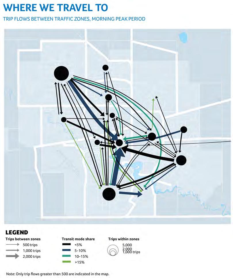
15 B B1 Current and Future Conditions Growth Plan Regina is growing. The OCP Growth Plan will accommodate population growth in the City to 300,000 people. Growth in the city will strengthen existing neighbourhoods, centres, and urban corridors while also supporting growth in new neighbourhoods (Appendix A Growth Plan from the OCP appended for reference). To support intensification, 30% of population growth will be directed to existing urban areas including 10,000 new residents within the City Centre. By focusing transportation planning on improving transportation choice, residents living in existing and new neighbourhoods will be able to meet their needs using a range of transportation choices. B2 How We Move At present, most trips in Regina are made by private vehicles. 85% of all peak period trips are made by car, of which 67% are made in singlepassenger automobiles; 18% of all peak period trips are made as an auto passenger 1. Active modes account for approximately 8% of all peak period trips, while transit accounts for only 3% of all peak period trips, which is low compared to similar Canadian cities 2. The majority of trips are made to access employment and schools during the morning peak period. Morning peak period travel is largely toward the City Centre, however, there are a number of longer trips, including from the northwest across the city and north/south trips made through the middle of the city. Some peak period travel flows to the City Centre have transit mode shares between 5-10% and trips to the University have transit mode shares of 15% or more. Certain lower-volume travel flows also exhibit transit mode shares greater than 15% (e.g. East Central to Ross Industrial, and West to South) 3. As the city grows and changes, travel patterns are also changing. Transit is increasingly becoming an attractive travel choice as the cost of driving and congestion increases. In 2013, improvements to transit service, including the introduction of more express and direct routes as well as scheduling changes, were successful in increasing city-wide transit ridership by 13.8% within the first months of implementation. 1 City of Regina Household Travel Survey Transportation Association of Canada (TAC) Urban Transportation Indicators - Fourth Survey. 3 There may be a degree of random sampling bias in these numbers due to the lower survey sample for these flows. FINAL DRAFT APRIL


16 FINAL DRAFT APRIL

17 Walking and cycling are also playing a greater role in how Reginans get around, particularly in central communities. On-street cycling is growing in popularity due to economic and health benefits and, with new residential opportunities being built in and around the City Centre, more people will be able to walk to work. There are real and perceived challenges with Regina being a "winter city. Walking and transit are frequently seen as unattractive modes and driving is typically perceived as the only viable choice, particularly in winter months. However, many cities across Canada with similar climates are active cities with high transit use. The challenge for Regina is to change attitudes and plan the transportation system to make multiple modes attractive yearround. B3 How We Will Move Regina possesses unique opportunities for multimodal transportation. The city's relative compactness is its greatest opportunity, with a higher proportion of short trips than most cities its size. More than half of all daily trips in the city are less than five kilometres in length, which can be easily travelled by walking, by cycling, or by taking transit. The concentration of employment in the downtown also creates a critical mass for high-quality transit services and increases the effectiveness of transportation demand management (TDM) programs. As the city grows, travel distances and commute times could rise. Providing increased choice of transportation modes and travel options is needed to help keep travel times and costs low. The focus for the TMP is not to penalize vehicle traffic, but instead to improve transportation options for all residents and encourage a multimodal approach to transportation planning. This includes walking, cycling, transit, ridesharing, and vehicle travel. Setting ambitious but achievable targets for sustainable transportation choices, in particular transit, will allow the City to support population and employment growth while maintaining the things residents like about the current transportation system shorter commute times and minimal congestion (Exhibit B-1). FINAL DRAFT APRIL
18 Exhibit B-1: Comparison of transportation today and the vision of the TMP Sustainable Transportation Limited increase in Vehicle Kilometres Travelled Improved Transit Service Safer Cycling and Pedestrian Environments Today Residents have limited options for travelling by other modes walking, cycling, and transit. It takes too long, it s not available, or it s not attractive. Despite being a compact city, most residents drive because transportation options aren t available and uses are spread out. Transit provides a basic level of service that is not as attractive as it can be. Travel times are not competitive with driving. Regina has a great off-street pathway system but riding a bike for day-to-day activities is a challenge. Walking is not seen as a viable option during the winter months (TMP) Residents will have more choice when travelling around the city. Transit will be a competitive alternative to driving. Citizens will be able to walk and cycle within their neighbourhoods and to get to work and school. In the future, sustainable modes (ridesharing, active modes, and transit) will increase from 29% to 36% of all peak period trips. By coordinating transportation and land use policies, the City will be able to limit the growth in vehicle kilometres that citizens travel to reach destinations and community amenities. Transit will provide competitive travel times and attractive service to more destinations and areas of the city. In the future 90% of all residents, secondary and post-secondary schools, and workplaces will be within 400 metres of transit routes and there will be more frequent service. The pathway system will continue to be the backbone to an all-season network, supported by an extensive system of on-street bikeways. The TMP will add ~90km of off-street pathways and ~140km of onstreet bikeways to the City s bike network. Improved sidewalk maintenance and snow clearing will improve accessibility and safety year-round. FINAL DRAFT APRIL
19 B4 How We Invest Historically, a large portion of Regina s transportation budget has been dedicated to roadways including street and bridge infrastructure renewal, traffic control and safety, streetscape development, roadway improvements and safety improvements. Past investment in transit was modest, largely to fund the purchase of replacement buses and vehicles, facilities such as shelters and fareboxes, and general office equipment. Sidewalk construction and repair is included within the roadways budget and construction of pathways and bike lanes are funded through specific annual budget requests. There is currently no dedicated funding for the construction of active transportation facilities. Existing active transportation expenditures consist primarily of asphalt recapping of multiuse pathways. Exhibit B-2 and Exhibit B-3 provide a breakdown of transportation capital and operating expenditures by mode over the last five years as well as the 2014 budget. The primary funding source for transportation capital expenditures is current contributions to capital. Other sources include the Gas Tax Grant (for street and bridge infrastructure renewal), Provincial grants and funding (specific street infrastructure renewal and traffic control and safety projects), Federal transit grant (2009), and Servicing Agreement Fees (SAFs) (directed towards multi-use pathways, streetscape, road network improvements and OCP projects). Per-capita funding for transportation in Regina tends to be lower than other peer cities for all modes (Exhibit B-4). Increasing transportation funding is necessary to allow the City to catch up and improve the condition of aging roadways and sidewalks in addition to investing in new infrastructure. 4 Without dedicated annual funding to improve active transportation facilities, it will continue to be challenging for the City to plan for and develop high quality pedestrian and cycling networks. This is evidenced by the slow development of the City s on-street bike network - the most recent on-street facilities were built in Additionally, since sidewalk construction and repair are funded through roadways, annual budgeting is unpredictable and may be allocated to other projects. Consistent and dedicated funding is essential to support expansion of the sidewalk network (filling missing linkages) and provide consistent repair and maintenance. Investing in all modes is needed to maximize the capacity of existing infrastructure and ensure the City can sustainably accommodate future population growth while minimizing congestion on roadways. The TMP will help to guide future investment to support all modes including balancing investment in new roadways with maximizing the capacity of existing assets. Increased investment in transit will also support an attractive network of direct routes with increased service that makes transit time- and cost- competitive and there will be dedicated funding to consistently develop and improve the City s active transportation networks. 4 City of Regina State of Roadways Infrastructure Report. FINAL DRAFT APRIL
20 Exhibit B-2: Transportation Capital Expenditures ( ) ($000 s) Average Roadways & $33,627 $27,453 $46,894 $33,369 $44,277 $34,818 $36,739 Transportation 1 Transit 2,3 $6,490 $2,910 $4,680 $4,406 $4,440 $8,130 $5,176 Active $0 $0 $195 $3,095 $0 $200 $582 Transportation 4 Multi-modal 5 $0 $500 $1,975 $1,679 $595 $0 $ Fluctuations in 2011 and 2013 were due to major roadway improvement projects. Includes capital programs (street and bridge renewal). Does not include facilities and roadway/traffic fleet costs 2. The higher capital budget in 2014 is for advanced replacement of 15 buses to address fleet reliability and maintenance cost issues. 3. Prior to 2011, transit fleet purchases and replacements were budgeted under the Community & Protective Services; transit and paratransit fleet expenditures are now budgeted as part of Fleet Services under the Corporate Services Division. Values in Exhibit include both budget amounts for Reflects asphalt recapping (capital program); 2012 includes $2.9 million to build the North West Link Multi-Use Pathway. 5. Expenditures noted as multimodal include the development of the OCP, the TMP, the Downtown Transportation and Transit Study, and a small amount allocated in 2013 for parking enforcement ($95,000). Exhibit B-3: Transportation Operating Expenditures ( ) ($000 s) Average Roadways & $24,002 $33,715 $27,624 $29,766 $31,848 $34,658 $30,269 Transportation 1 Transit 2 $23,815 $24,280 $24,730 $26,384 $27,614 $30,520 $26,224 Planning 3 $310 $150 $148 $642 $769 $0 $ Roadways expenditures include administration, operations, street sweeping, winter maintenance, alley maintenance and sweeping, concrete and asphalt services, roadway preservation, asphalt production and field services, traffic engineering, signals and lighting, traffic control and parking, and street lighting. 2. Transit expenditures include conventional transit and paratransit services. 3. Planning operating costs include multi-modal expenditures such as a taxi study, OCP, support services (e.g., modelling) and parking, under the City Planning & Development Division (CP&D). FINAL DRAFT APRIL
21 Exhibit B-4: Transportation investment in Canadian cities (*approximate values) City Population Roadways Capital ($/capita) Transit (Municipal Operating Contribution, $/capita) 5 Active Transportation Capital ($/capita) Regina 6 210,556 $174 $63 $3 Saskatoon 7 246,300 $190 $85 $3 London 8 369,940 $190 $57 $4 Winnipeg 9 675,100 $180 $62 $4 Halifax ,679 $140 $141 $7 Edmonton ,000 $305 $167 $8 5 Canadian Urban Transit Association. Canadian Transit Fact Book Operating Data 6 City of Regina, Based on average Capital expenditures (see Exhibit B-2) 7 City of Saskatoon 2014 Preliminary Corporate Business Plan and Detailed Budget 8 City of London Capital Budget City of Winnipeg 2014 Preliminary Budget; Capital Project Detail 10 City of Halifax Proposed Project Budget 2014/15 11 City of Edmonton Capital Budget FINAL DRAFT APRIL
22 C Transportation Directions C1 Offer a range of sustainable transportation choices for all Policies and actions within this Direction complement the overarching Growth Plan and Infrastructure Policies presented in the OCP and support the Community Priority to Create better, more active ways of getting around. Regina is a relatively compact city, with the majority of built areas within a 5-kilometre distance of the downtown core, a distance that can be easily travelled using active modes of transportation and transit. However, even though many daily trips in Regina are short, historical patterns of land use and development have supported the movement of motor vehicles over other modes. The City can offer sustainable transportation choices by balancing roadway improvements with investments in pedestrian, cycling, and transit facilities to make them more effective and attractive to users. In addition, enhancing transportation choices is important to increase mobility and accessibility for people of all backgrounds and needs. Many low-income families may not be able to afford a vehicle and recent immigrant populations are less likely to have a driver s license. Additionally, aging populations and those with reduced physical mobility are more reliant on transit services and pedestrian infrastructure. Ensuring that the transportation system supports all users and is designed with universal accessibility in mind is important to providing access to employment and community amenities for all citizens. Strategies around transit, walking, cycling, and carpooling, combined with programs that educate and maximize existing transportation infrastructure through travel demand management (TDM), will offer transportation choices that are easy, affordable, sustainable, and more enjoyable for all users. What We Heard About Sustainable Transportation Choices Infrastructure investments favour the use of private motor vehicles over other modes; priority should be placed on investing in infrastructure that benefits all modes Transportation planning needs to be more peoplefocused so all citizens can move through the city with ease and safety People currently choose to drive motor vehicles because it is the most convenient; options should be available that allow people to choose the mode that suits the trip being made Increased visibility and promotion of alternative modes is needed Transportation options should support sustainability more holistically Goal 1: Mode share targets will inform transportation planning and policies. Mode share targets are important to help inform where infrastructure investments should be directed and in what ways the efficient use of infrastructure can be improved. They are also useful for measuring progress and tracking how effective policies and initiatives are at achieving their goals. Setting ambitious long-term targets is important to support the Transportation Directions of the TMP; however, it is equally important to define realistic and achievable interim targets at regular intervals or in conjunction with other milestones. This allows the TMP s policies and actions to be measureable and flexible over time while providing a road map to achieve long-term objectives. A number of considerations were made in setting mode share targets for Regina including current travel behaviour as well as comparison to peer cities that have achieved measureable progress on increasing sustainable mode shares (Quebec FINAL DRAFT APRIL
23 City, Kitchener, Hamilton and Victoria are examples of intermediate size cities that have seen increases in mode shares for active transportation and/or cycling in the last decade). Perhaps most importantly, the mode share targets take into account the objective of providing increased transportation options and balancing trips between modes, and the benefits that go along with this including reduced or deferred road expansion costs and reduced personal transportation costs (e.g. fuel and parking). The mode share targets for Regina are considered modest,and reflect that the TMP is a transitional plan. The mode share targets should be reviewed and adjusted every five years as part of TMP updates. POLICIES AND ACTIONS 1.1 Adopt short-term and long-term mode share targets for city-wide travel by the 300,000 population horizon (Exhibit C-1). Exhibit C-1: City-wide mode share targets for peak period travel TRAVEL MODE CURRENT MODE SHARE SHORT- TERM MODE SHARE TARGET LONG-TERM MODE SHARE TARGET Single- 67% 65% 60% Occupant Drivers Auto 18% 18% 20% Passenger Transit 3% 4% 6% Walking or 8% 9% 10% Cycling Other (taxi and school bus) 4% 4% 4% Current mode share based on 2009 Regina Travel Study, shares are for the AM Peak Period. 1.2 Identify and adopt district-specific mode share targets for trips to downtown and to the University of Regina/SIAST recognizing unique transportation needs and opportunities in these districts, such as the higher potential for sustainable transportation (Exhibit C-2 and Exhibit C-3). Exhibit C-2: Downtown Regina mode share targets TRAVEL MODE CURRENT MODE SHARE LONG-TERM MODE SHARE TARGET Single-Occupant 64% 45% Drivers Auto Passenger 14% 20% Transit 4% 15% Walking or Cycling 17% 20% Current mode share based on 2009 Regina Travel Study Exhibit C-3: University of Regina/SIAST mode share targets TRAVEL MODE CURRENT MODE SHARE LONG-TERM MODE SHARE TARGET Single-Occupant 55% 40% Drivers Auto Passenger 15% 20% Transit 20% 25% Walking or Cycling 10% 15% Current mode share based on University of Regina Master Plan Consider adopting mode share targets for other key districts and trip generators in the city (e.g. Ross Industrial Park, cumulative high school travel). 1.4 Incorporate mode share targets as a planning tool in new developments and in corridor and neighbourhood planning. 1.5 Establish targets for operational and capital investment in transportation, such as transit service hours or new kilometres of bikeways, to help achieve mode share targets. FINAL DRAFT APRIL
24 1.6 Conduct a city-wide travel survey every five years to measure progress toward achieving mode share targets and gauge the success of TMP goals and policies. This will also help to keep the City's travel demand model up to date, and ensure that transportation investments are made wisely and with timely data. The next travel survey should be conducted by 2016 in order to establish a baseline for implementation of the plan and to align with the Statistics Canada Census cycle. 1.7 Lobby the provincial government to enable the City to use provincial funding to invest in other modes of transportation in addition to roadway investments. Goal 2: The transportation system will provide a greater range of multi-modal transportation choices for all seasons. The TMP aims to direct planning and investment across all modes to offer a greater range of choices throughout the city and in all seasons. Providing a higher degree of transportation choice not only makes it easier to get around the city, but it also expands live, work, learn, play opportunities. For the past few decades, planning of and investment in transportation infrastructure in Regina has concentrated on maximizing the efficient movement of automobiles. However, with limited improvements to transit, walking, and cycling, this imbalance has limited transportation choices in some areas of the city. The TMP seeks to rebalance the city s approach to transportation in order to benefit all users. Determining the level of service of a roadway is traditionally oriented toward automobile travel based on traffic volumes, the capacity of the roadway, and delay to motor vehicles. The TMP proposes a new way to evaluate roadways based on a multi-modal level of service (MMLOS) model, which assesses the service level, functionality, and safety of all modes with the goal of balancing multi-modal needs. The MMLOS model recognizes that tradeoffs will be necessary, as increasing the level of service to one mode may have impacts on others. To achieve a greater balance, most MMLOS models score different elements of all modes in order to develop a comprehensive level of service score. It is important that the way in which the various modes and transportation elements are scored is developed for different contexts (e.g. districts with high pedestrian priority, express transit routes). Potential elements to be considered in the development of MMLOS analyses for each mode are shown in Exhibit C-4. FINAL DRAFT APRIL
25 Exhibit C-4: Sample indicators for evaluating Multi-modal Level of Service (MMLOS) Walking Cycling Transit Accessibility Automobiles Trucking and Goods Intersection width (ease Speed differential Availability and Sidewalk provision Volume-to-capacity Safety of crossing) Distance between crossings Conflicts Crossing times Environment/ amenities Maintenance Travel time Safety (compared to adjacent traffic) Degree of separation from adjacent traffic Adjacent parking Facility availability Facility maintenance Conflicts Travel time Amenities Frequency Travel Time Reliability Integration Ratio of transit time to auto time Delay to transit passengers from congestion Amenities Sidewalk accessibility Crossing times Accessible crossing signals Sidewalk Maintenance Paratransit service Safety ratio Vehicle flow Travel time Safety Travel Time Geometric requirements Safety Safety Improving universal accessibility is another important aspect of providing expanded transportation choices for all users. This includes ensuring that pedestrian infrastructure is designed and maintained to provide comfort and safety for residents of all ages and abilities, and providing accessible transit services and paratransit services for customers with disabilities and reduced mobility. Additionally, increasing connectivity between different modes allows citizens more options for how to navigate the city. Providing more transportation choices yearround requires special attention during the winter months when mobility and accessibility are greatly impacted by snowfall and cold temperatures. A winter travel strategy can provide high-level guidance for how the City will coordinate winter roadway, sidewalk, and pathway maintenance including identifying priority corridors for snow clearing, addressing winter accessibility issues, and assessing improvements to transit services. A winter travel strategy would serve to integrate and coordinate existing policies and processes and provide direction for the development of future winter maintenance policies. POLICIES AND ACTIONS 1.8 Establish a cross-divisional internal Transportation Advisory Committee to oversee the implementation of various plans and projects related to the TMP and divisional work plans. 1.9 Ensure that multi-modal transportation is a key part of the City s planning, operations, and processes to expand transportation choice. Justification will be provided where it is not feasible due to such factors as distance, safety, or cost Adopt a lead-by-example policy to meet universal accessibility needs in transportation infrastructure and services (transit, sidewalk and curb ramp design, audible crosswalks) Ensure connectivity between transportation modes. This may include park-and-ride programs, pathway and street connections, bus connections to bike and pedestrian destinations, and filling sidewalk gaps to transit stops. FINAL DRAFT APRIL
26 1.12 Review and update City policies and standards to reflect multi-modal transportation needs for all seasons. For example, acceptable walking distances will take into account the challenges of walking in colder weather Incorporate the concept of a multi-modal level of service (MMLOS) when assessing transportation needs at all levels of planning and develop a standard set of assessment criteria to utilize for MMLOS analysis (see Direction 5 Goal 2) Develop a winter travel strategy that integrates and complements the City s Winter Maintenance Policy and that clearly defines priorities, level of service expectations, and responsibilities for winter transportation for all modes. The strategy will consider: roadway snow-clearing; off-street and on-street cycling routes that will be ploughed through the winter; sidewalk and pathway clearing (including pedestrian spaces such as the City Square plaza); condition of accessibility ramps at public facilities; coordination of pathway and sidewalk clearing (Wascana Centre Authority, City of Regina Parks Dept and Roadways Dept); snow clearing at transit stops; increased enforcement of sidewalk snow clearing by property owners and occupants, where specified in the Clean Property Bylaw (No. 9881); parking bans for on-street snow removal with increased enforcement; warrants for transit shelter locations including the potential installation of heated shelters in key locations; and, other components as identified. 12 Guidance can be found in the TRB National Cooperative Highway Research Program Report 616: Multimodal Level of Service Analysis for Urban Streets ( FINAL DRAFT APRIL
27 Goal 3: A Complete Streets Framework will balance the needs of all users. Complete streets is an approach to designing, planning, operating, and maintaining streets in such a way that users of all ages, abilities, and modes of transportation are taken into account. Design elements can include sidewalks, bikeways, dedicated bus lanes, accessible transit stops, accessible sidewalks and crossings, multiple crossing opportunities, and median refuge islands. Complete streets also reinforce the role of streets as places and increase the comfort of users through urban design improvements including the provision of street trees and plantings, street furniture, adequate lighting, and use of highquality materials. Complete streets are designed to be reflective of neighbourhood context and street function while balancing the needs of all users. Adopting a Complete Streets Policy allows all City staff (planners, engineers, maintenance and operations staff) to consistently design and operate streets with all users in mind and to work with elected officials, stakeholders, and community members to ensure streets provide safe access for all users. Potential benefits of complete streets include: increased safety for all road users, including children, older adults, and persons with disabilities; expanded transportation choices and increased access to live, work, learn, play opportunities; improved affordability of travel; increased support for the development of complete neighbourhoods; improved livability through encouraging active transportation; increased environmental benefits of sustainable modes; and, enhanced economic opportunities through the creation of attractive places to invest and do business. A Complete Streets Policy will support many of the priorities and objectives of the TMP and the OCP. Many aspects of complete streets are integrated throughout the TMP, including through the coordination of land use and transportation planning, support for complete neighbourhoods, the integration of multiple modes within roadway design, and consideration in implementation strategies. The Framework for Complete Streets (Appendix B) identifies policy support for complete streets within the TMP and can be used to support the City in planning and designing complete streets prior to the development of a formal Complete Streets Policy. POLICIES AND ACTIONS 1.15 Create a Complete Streets Policy using the Framework for Complete Streets (Appendix B) that fits the context of Regina to allow planners and engineers to consistently design and operate streets with all users in mind Develop a strategy to identify existing corridors that should be transitioned to complete streets. The strategy will prioritize streets with existing potential to incorporate multiple modes during road reconstruction (e.g. road diets, planting street trees as part of road reconstruction). Coordination between departments will be important to allocate funding for reconstruction projects and reduce overall costs of reconstruction (see Direction 6). 13 Complete Streets for Canada and The National Complete Streets Coalition provide resources to help municipalities draft complete streets policies FINAL DRAFT APRIL
28 1.17 Support the development of complete streets in Regina by: coordinating complete streets and complete neighbourhoods as part of the land use planning process (Direction 2); integrating complete streets principles into existing documents, such as the Development Standards Manual; developing a toolkit for accommodating multiple modes on different classes of streets (e.g., local, collector, arterial) and through the adoption of standard roadway crosssections for new streets (Direction 5); identifying best practices for retrofitting existing streets to accommodate multiple modes; ensuring complete streets are part of the planning, design, and assessment of all new and renewed transportation projects; and, placing a higher priority or preference for options and projects that reflect complete streets principles Establish evaluation criteria (e.g. checklists) and monitor the progress of achieving the objectives of the Complete Streets Policy, once developed. Criteria should include factors such as access to multiple modes of travel and travel safety statistics Review the Complete Streets Policy, once developed, as part of future updates to the TMP to reflect changing travel patterns, needs, and urban contexts. Goal 4: Travel Demand Management will be a key component of sustainable transportation. TDM is the use of policies, programs, and/or services to influence travel behaviour towards more sustainable choices. TDM encompasses a wide range of strategies to encourage travellers to change their travel choices including shifting modes away from single occupant vehicles (SOVs) (e.g. active modes, transit, carpooling), reducing the number of trips they make (e.g. telecommuting), and travelling more efficiently (e.g. travelling outside of peak hours). TDM is a key tool in transportation planning and operations and represents a cost-effective way to ease congestion, expand transportation choice, and reduce the need to expand capacity. TDM measures are diverse and aim to make sustainable modes more attractive and competitive by making them better understood and accepted (e.g. marketing and education), more available (e.g. increased transit service), faster and more direct (e.g. HOV lanes), more reliable (e.g. transit priority measures), safer (e.g. secure pedestrian environments), affordable (e.g. incentives for sustainable travel), and more fun and rewarding (e.g. promoting healthy lifestyles). There are currently a number of existing TDM initiatives within the city (i.e. employer-specific programs, carsharing), however there are still many opportunities to support a shift in travel behaviour. FINAL DRAFT APRIL
29 As part of supporting TDM, many cities have adopted TDM strategies for their municipal corporations and act as leaders to reduce SOV trips and encourage modal shift. Commonly this has included offering reduced fare transit passes to municipal employees, providing preferential parking for carpooling employees, supporting telecommuting, and providing individualized trip planning and ride matching resources. Many cities also hire a municipal TDM coordinator to promote TDM programs within the municipal corporation as well as provide education and outreach to the community. The City of Kitchener recently developed a comprehensive TDM Plan including a TDM program for municipal staff. They estimate the program will reduce the staff SOV mode split by 6.5% over five years (a reduction of approximately 390 vehicle kilometers per employee annually). Taking the lead on TDM strategies will be an effective way for the City of Regina to build in-house experience and promote the benefits of TDM to other large public and corporate employers. Potential benefits of a City TDM program The City of Regina employs approximately 2,000 people. If, on average, employees commute 12km per day, and we assume a similar modal split to the city-wide trend (67% SOV), single occupant vehicle trips by city employees average 80,400km each week. If the single occupant mode split were reduced by 7%, employee vehicle travel would be reduced by approximately 436,800km per year. Benefits could include reduced congestion in hotspots (downtown), reduced demand for parking spaces, environmental benefits of lower emissions, less strain on infrastructure, and health benefits of increased physical activity. Why use Travel Demand Management? It creates efficiencies: TDM minimizes infrastructure needs by reducing the number and length of trips, and by shifting trips away from congested corridors and time periods. It offers increased flexibility and versatility: TDM can be carefully targeted to specific audiences (e.g. seniors), destinations (e.g. a hospital), travel modes (e.g. cyclists), travel corridors (e.g. along a freeway), trip purposes (e.g. school commutes) or timeframes (e.g. festivals). It is easy to implement: TDM initiatives can be planned and delivered quickly, and can be tailored to make the best use of available budgets. POLICIES AND ACTIONS 1.20 Adopt a lead-by-example policy to promote TDM strategies within the City of Regina municipal corporation. TDM strategies that could be pursued by the City include: promoting existing TDM initiatives and activities such as the telecommute program, carpool.ca ride matching service, and Commuter Challenge; providing increased flexibility of work hours to reduce congestion levels at peak periods; providing priority parking stalls for employees who carpool; participating in a corporate carshare program and providing a small fleet of carshare vehicles at City facilities for staff to use for work (e.g. site visits); examining financial incentives for employees who commute by transit and active modes (reduced fare transit passes); and, dedicating resources and support to promote and monitor corporate TDM initiatives. FINAL DRAFT APRIL
30 1.21 Increase the visibility of sustainable modes and provide educational information about TDM. This will include: developing a unique brand under which TDM initiatives in the city will be promoted; providing information about sustainable modes on the City s website and other channels to build awareness and promote TDM programs; and, promoting individualized or community-based marketing efforts to tailor TDM strategies to specific markets or individuals Hire a TDM Coordinator to serve as a resource and liaison for city-wide TDM initiatives Explore the expansion of the Community Grants Program to provide an annual budget for TDM initiatives that encourage local organizations and businesses to pilot or initiate TDM strategies (e.g. printing TDM information brochures, setting up carpool connection website) Monitor and implement, when appropriate, innovative applications of technology that have potential to change travel behaviour, improve transportation options, or increase awareness of TDM Target TDM initiatives to key community partners and institutions that can make a large impact (University of Regina, SIAST, high schools, elementary schools, public sector employees, crown corporation offices, large employers, seniors residences). Strategies could include flexible work hours, employer transit passes, carpool services, reserved parking for high-occupancy vehicles, and carshare programs Partner with community leaders to improve the perception, attitudes, and awareness of alternative modes Encourage more community events and festivals to integrate TDM initiatives in their programming. Build off the success of current event-related TDM initiatives such as the Football Express transit service for Roughrider games, transit shuttles that circulate between pavilions for the Mosaic Cultural Festival, and community bike valet services at the Regina Folk Festival Support advocacy groups and organizations that promote sustainable transportation modes. FINAL DRAFT APRIL
31 C2 Integrate transportation and land use planning Policies and actions within this Direction complement the overarching Land Use and Built Environment Policies presented in the OCP and support the Community Priority to Develop complete neighbourhoods. Land use and transportation are two key aspects of urban development that are naturally linked and influence one another. Land-use planning concerns itself with the development and distribution of land uses (e.g. residential, commercial, industrial) and the creation of destinations (e.g. where people live, work, shop). Transportation planning, meanwhile, looks at how people will access those destinations and land uses. Additionally, residents often make decisions about where to live and work based on how easily they can access employment and education centres as well as community services. Many cities are starting to integrate land use and transportation planning more closely to balance land use objectives, development pressures, and transportation infrastructure needs. Reducing the number and duration of trips residents must make in order to access community amenities, work, school, and home, and supporting multiple modes of transportation is of interest. Long-term opportunities for transportation demand management (TDM) can be found in structuring land use in more efficient forms and orienting development along transit spines. By looking at opportunities to increase density of neighbourhoods and provide better access to community amenities and services, roadway infrastructure and land resources can also be designed and used more efficiently. Regina s older neighbourhoods include a mix of uses and offer local community amenities to residents within a walkable or bikeable distance. However, in the last 40 years, many neighbourhoods have been planned to separate uses. This makes it difficult for residents to conveniently access destinations by modes other than by car. For neighbourhoods and developments that were not initially designed to easily connect residents with destinations or support multiple modes, accessing community amenities and services without a vehicle can be difficult. A lack of coordination between land use and transportation planning has also resulted in some roadways being over-built while others experience high traffic volumes and congestion. The Growth Plan presented in Regina s OCP directs 70% of growth to new neighbourhoods. Intensification of existing areas will comprise the remaining 30% of growth, and will play an increasingly important role in shaping the city s growth pattern (Appendix A). Intensification will be particularly focussed within the City Centre and along certain express transit corridors that are identified as urban corridors. Proposed growth and development needs will be considered in conjunction with improvements to the transportation system in order to provide adequate service to these areas and to ensure that new neighbourhoods are designed to make use of existing transportation infrastructure. The OCP also promotes the development of neighbourhoods that provide access to destinations by multiple modes and encourages new planning and development initiatives that conform to Complete Neighbourhoods Guidelines (mixed-uses, housing variety). Designing complete streets, which feature a range of transportation modes, will help support these vibrant, active complete neighbourhoods. By planning land use and transportation concurrently, Regina can tailor new and existing neighbourhoods to support multiple modes of transportation and allow all citizens to access local employment and community destinations efficiently. FINAL DRAFT APRIL
32 What We Heard About Land Use and Transportation Long-term transportation needs should be considered as part of all developments A number of neighbourhood designs are outdated with indirect roads that are not conducive to walking and biking All neighbourhoods (existing and new) should be designed to support multiple modes of transportation Transportation planning in new neighbourhoods seems like an afterthought; it should be a priority before a neighbourhood is built More direct connections between neighbourhoods (new and existing) are needed Reinvesting in existing rights-of-way can support infill, mixed-uses, and increased density, making transportation systems more efficient Complete streets are successful in complete neighbourhoods; land use and transportation policies need to support each other Land use patterns impact infrastructure needs and costs, supporting multiple transportation modes can reduce infrastructure impacts Goal 1: Transportation and land use planning processes will be coordinated. Regina is growing and the OCP has identified areas for greenfield growth and targets for intensification within existing built areas over the next 25 years. It will be important for long-range land use plans to be realized in conjunction with transportation planning to allow increases in population and employment to be accommodated within existing infrastructure. In addition, transportation infrastructure will need to be planned to meet the capacity needs of new neighbourhoods while still supporting the goals of the OCP and ensuring that roads are designed for multiple modes to move people efficiently. Long range land use and transportation planning should be done with a view to connect new and existing neighbourhoods and grow a cohesive city-wide transportation network over time. In addition to coordinating long-range land use and transportation planning activities, the process through which information about shortterm planning and transportation projects is shared is also important. A comprehensive approach is needed to coordinate transportation planning and land-use planning activities for new neighbourhoods, site developments, and neighbourhood renewal projects. Creating a structure to improve communication between planning, engineering, public works, and operations staff will help to identify projects that overlap or may impact scheduled work. The City s existing database for ongoing infrastructure projects is currently not well supported and there is limited access to this database by all departments. Expanding on this existing database or establishing a new central hub to share information about ongoing projects will help to coordinate work between various departments, allowing for efficiencies and a more integrated approach to land use and transportation planning. FINAL DRAFT APRIL
33 POLICIES AND ACTIONS 2.1 Ensure land use and transportation planning goals are achieved through regular communication, coordination, and collaboration between planning, engineering, operations, and maintenance staff. This can be achieved through: establishing a strategy, and improving existing mechanisms, for clear communication between departments to support coordination regarding upcoming projects; ensuring all appropriate departments are represented in major projects and planning programs; and, developing a central database to provide easy access to information, resources, and other project data between departments. 2.2 Employ integrated land-use forecasting and transportation models as part of long-range planning and engineering activities. 2.3 Ensure long-range development goals identified in the OCP (complete neighbourhoods, mixed-use development) are supported through appropriate transportation investments, such as improved transit and pedestrian infrastructure. 2.4 Update the Zoning Bylaw to provide incentives for development that expands transportation choices and supports the goals of the TMP. Updates may include: increasing density allowances around planned transit nodes and along planned transit corridors; reviewing opportunities to reduce parking space provision, in particular for surface parking lots, within new development (e.g. development near transit, unbundling parking) (see Direction 2 Goal 5); extending the current bonusing agreement framework to include areas outside the downtown; and, expanding the current bonusing agreement framework to include transportation-related services as well as the provision of transportation infrastructure (transit shelters, bike parking, streetscape improvements). 2.5 Use land use planning tools such as secondary plans, concept plans, and site plan approvals to ensure that: land uses support transportation investments and plans including express transit corridors and transit nodes; the design of streets is complimentary to existing land uses (and proposed land uses) during reconstruction; multiple modes of transportation are integrated; and, transportation gaps and needs are identified and addressed. FINAL DRAFT APRIL
34 2.6 Update Map 5 Transportation in the OCP to reflect the TMP transportation networks as part of a future amendment. 2.7 Ensure that the transportation network maps developed through the TMP are updated as secondary and concept plans for new neighbourhoods are approved. 2.8 Develop site design guidelines that support and promote multi-modal transportation. This will include providing active transportation facilities (e.g. bike racks, sidewalk connections to buildings) and connections to transit. Guidance can be found in publications by recognized professional organizations Develop a strategy to protect land for transportation needs, including road rightsof-way and future transit corridors, as part of the land use planning and approvals processes (e.g. identifying easements and land acquisitions through corridor studies). Real Estate staff should be made aware of future corridor requirements to inform where land should be retained by the City or purchased to accommodate future transportation needs. 14 Canadian Institute of Transportation Engineers (CITE) Promoting Sustainable Transportation Through Site Design. Washington DC Goal 2: Transportation will support vibrant, safe, and well-connected complete neighbourhoods. Regina s OCP encourages planning and development initiatives to follow Complete Neighbourhoods Guidelines, which feature a mix of uses (residential, community services, employment). Transportation planning can be used to support the development of complete neighbourhoods through defining neighbourhood structure and ensuring multi-modal accessibility and connectivity to neighbourhood destinations. Additionally, the organization of streets and the design of transportation infrastructure can be used to foster a sense of place, affirm the role of streets as places within neighbourhoods, and ensure that the safety and comfort of users of all ages and abilities are taken into account. Neighbourhood structure and development is greatly defined by road layout and design. Designing street networks in a grid pattern is often referenced as one way to improve the ability of citizens to move through their neighbourhoods efficiently and access community amenities and services. However, in addition to a well-connected street layout, the location of transportation infrastructure and services such as transit nodes can also greatly influence the structure and layout of neighbourhoods and influence the viability of different land uses (e.g. commercial, high-density residential) to be supported within a neighbourhood. Developing transportation infrastructure so as to provide safe and efficient access within neighbourhoods as well as between neighbourhoods greatly supports the development of complete neighbourhoods. Transportation planning that integrates pedestrian connections, cycling connections, and transit routing can provide residents with convenient access to employment centres, community services, and open spaces, allowing them to meet most of their daily needs. Designing roadways with all users in mind and investing in public realm improvements reinforces the role of streets as important public spaces and destinations. Creating safe and vibrant streetscapes contributes to improved quality of life and fosters a sense of place and community. FINAL DRAFT APRIL
35 POLICIES AND ACTIONS 2.10 Update the Subdivision Bylaw to incorporate transportation infrastructure as a mechanism to help define neighbourhood structure (road layout, street length, and block pattern) and support multiple land uses and multiple modes. Elements that may be considered include: the development of neighbourhood street layout patterns and block sizes that provide easy access to employment, services and community amenities by all modes; the location of transit nodes and corridors to support a variety of land uses; and, Easy access from the neighbourhood to the rest of the city Ensure neighbourhood transportation planning provides integration of multiple modes within neighbourhoods and connectivity between adjacent neighbourhoods. This would include: designing safe and accessible pedestrian, cycling, and transit routes within neighbourhoods; providing safe and accessible streets, pedestrian connections, cycling connections, and transit routing between neighbourhoods; and, ensuring residents can access places of employment and community amenities by multiple modes Utilize transportation planning as a mechanism to foster a sense of place, character, and identity within the public realm. This could include: adopting a Complete Streets Policy that ensures all users are considered when designing transportation infrastructure; developing roadway cross-sections and design guidelines that support safe and comfortable routes for all users (bike lanes, pedestrian routes with some separation from vehicle traffic); utilizing the hierarchy of the street network as a positive character defining element in the public realm; and, emphasize the role of streets as key public spaces and destinations by creating neighbourhood streetscaping programs, supporting place making activities, and providing resources to make improvements in the public realm Coordinate complete neighbourhoods and complete streets initiatives as part of ongoing integration of land use and transportation planning in new and existing neighbourhoods. FINAL DRAFT APRIL
36 Goal 3: Existing neighbourhoods and employment areas will have enhanced transportation options. Like many cities, Regina s zoning has typically separated land uses and many residential neighbourhoods have been developed at lower densities. Similarly, roadways constructed 20 years ago were primarily designed to facilitate the efficient movement of motor vehicles. As such, existing neighbourhoods may not meet the mobility needs of all citizens and support longterm planning priorities. Examining ways to improve transportation within existing neighbourhoods is essential to meet the objectives of the TMP. Potential approaches include: Filling gaps in the transportation network to service existing neighbourhoods (improved cycling connections, direct transit routes, location of transit nodes); and, Modern zoning and land use development standards for infill development (e.g. lowered surface parking space requirements for commercial developments, provision of cycling amenities, increased density along transit corridors) Benefits of improving transportation options and services in existing neighbourhoods include better connecting residents with local and city-wide services and community amenities and supporting the transportation and land use objectives of creating complete neighbourhoods. Updates to municipal bylaws and policies, including the Zoning Bylaw and Development Standards Manual (DSM), will be needed to support multiple modes of transportation in existing neighbourhoods. The Zoning Bylaw will need to enable higher density development and mixed uses within existing neighbourhoods and examine ways to integrate multi-modal transportation requirements and exceptions into all zones (such as parking requirements, cycling amenities, site design considerations). Similarly, updates to the DSM, which primarily provides direction for new neighbourhoods, will be needed to include standards and guidelines for infill development and retrofitting existing streets. POLICIES AND ACTIONS 2.14 Update the Zoning Bylaw to enable infill developments of higher densities as well as those that incorporate mixed-uses and to support expanded transportation choices in existing neighbourhoods. Updates may include: increasing density allowances to encourage higher density and transitoriented development at transit nodes and along primary transit and express transit corridors; permitting mixed uses in additional zones; reviewing exceptions to parking standards in additional zones to support infill development; and, expanding bike parking requirements to additional zones (in particular residential zones) Expand existing DSM to include guidance on infill development in order to support enhanced transportation choices in existing neighbourhoods. FINAL DRAFT APRIL
37 2.16 Explore potential interim measures to improve the accommodation of multiple modes within existing neighbourhoods during the process of updating City bylaws and the DSM Ensure that transportation needs are identified and that transportation design is included in the neighbourhood planning process Improve existing transportation infrastructure to support multiple modes of transportation and increase universal accessibility within existing neighbourhoods. This could include: improving sidewalk connections to neighbourhood destinations; increasing transit service; increasing transit amenities; addressing gaps in pedestrian access to transit stops; accommodating cycling infrastructure (potentially through road diets); integrating traffic calming on local streets; including audible pedestrian signals; integrating accessible curb ramp designs, during replacement; improving wayfinding (signage, name blades); enhancing pedestrian environments; and, improving signage and pavement markings standards for crosswalks and bike routes Use cycling, pedestrian, transit, and road networks to identify and address gaps in existing transportation infrastructure and improve connectivity between neighbourhoods Leverage infill development in existing neighbourhoods to address transportation needs and gaps and to expand multi-modal transportation options Update the Transportation Impact Analysis guidelines to include a strategy to monitor the cumulative impacts of infill development projects and establish when a Transportation Impact Analysis should be required for infill projects Incorporate multi-modal transportation considerations into Transportation Impact Analysis requirements for infill projects (e.g. additional bus stop provision) Review applications for roadway/alley closures and city property sales to ensure that existing transportation linkages and opportunities for future linkages are maintained. FINAL DRAFT APRIL
38 Goal 4: New neighbourhoods and employment areas will incorporate multi-modal transportation options. In addition to integrating land use and transportation planning on a city-wide basis, site and subdivision planning also greatly impact the mode of transportation people choose to use. Modern planning practices highlight the importance for new neighbourhoods and development projects to integrate multiple modes in their design and support mobility for all users. Regina s current development review processes require consideration for traffic studies regarding how new neighbourhoods and development projects will impact the road network; however, a more holistic approach to site design that supports the integration of multiple modes to mitigate travel demand is needed. Integrating multi-modal transportation considerations into the planning approvals process can help to promote neighbourhoods and development projects that provide expanded travel options while minimizing impacts on surrounding transportation infrastructure. Land-use goals of mixed uses and increased density can also be supported by considering how to efficiently use existing infrastructure and support multiple modes. Many cities across Canada are starting to integrate TDM into planning approvals processes to reduce trip generation and support expanded transportation choices. Requiring the completion of a TDM plan or checklist ensures that developers identify how single-occupant vehicle (SOV) trips will be reduced and how increased mode choices will be supported within a site or subdivision plan. Accommodating travel demand through transit, walking, cycling, and carpooling within neighbourhoods is encouraged. Checklists can also be scored to weigh certain measures more heavily (e.g. reduced parking provision), with a minimum score required for a development application to proceed. This approach can provide flexibility for developers to choose what strategy best matches the development context. Municipalities have found these tools useful, even if they are non-binding, to increase TDM provision and for developers to promote the sustainable aspects of their projects. The City of Regina is currently updating its Transportation Impact Analysis guidelines and is developing a scorecard evaluation for new neighbourhood developments. Integrating TDM considerations into these development approvals processes can support sustainable transportation choices in a way that does not create unnecessary burden on developers. Supporting multiple modes in new neighbourhoods will also require greater investment in transit and active transportation infrastructure. Currently, Servicing Agreement Fees (SAFs) for new neighbourhoods can be used to fund roadway infrastructure, including bike lanes, sidewalks, pathways, and some transit infrastructure (bus stops, signage). However, new transit vehicles cannot be funded through SAFs, nor can additional service hours to expand transit services into new neighbourhoods. The City will need to examine additional funding mechanisms to support multiple modes as part of new developments and new neighbourhoods. POLICIES AND ACTIONS 2.24 Ensure new neighbourhoods provide direct connections to existing transportation networks (e.g., bike routes, transit) and protect for future neighbourhoods and employment areas to connect to these networks Develop criteria to direct the types of facilities that are to be included on different road classifications (see Direction 4 Goal 3) Ensure new neighbourhoods and employment areas provide direct connections to adjacent neighbourhoods and employment areas. Preserving the existing grid network should be a priority with connections between neighbourhoods occurring on collector streets where possible (see Direction 5 Goal 5). FINAL DRAFT APRIL
39 2.27 Ensure new neighbourhoods and employment areas protect for connections to future neighbourhoods and employment areas. Non-permanent dead end street stubs should be used to protect for future connections in conjunction with phased development. Where current barriers exist (e.g. railway corridors), protecting for future connections is still recommended Ensure infrastructure in new neighbourhoods and employment areas is designed to support universal accessibility (e.g. sidewalk design, curb ramps, crosswalk design, installation of audible pedestrian signals) Update the Zoning Bylaw to enable the development of new neighbourhoods that make efficient use of existing infrastructure and transportation services. This may include: promoting increased density along express transit corridors and within a walkable distance (e.g. 400 metres, or approximately five minutes, is a common suggested walking distance from a transit stop); increasing the provision of mixed-uses in additional zones; reviewing parking standards in neighbourhoods located near planned transit corridors and transit nodes (see Direction 2 Goal 5); and, ensuring the provision of cycling facilities and amenities near employment and community centres, and within new development projects Update the planning approvals process to integrate consideration for multi-modal transportation in site, subdivision, and concept plans. This could include: requiring that Transportation Impact Analyses integrate a multi-modal approach; requiring Transportation Impact Analyses to incorporate transportation and multi-modal needs of a broader area surrounding new neighbourhoods and developments; and, requiring developers to complete a TDM checklist as part of the site/subdivision scorecard currently being developed for new neighbourhoods Develop a strategy to monitor the cumulative impacts of rezoning and subdivision iterations in new neighbourhoods to establish when an updated Transportation Impact Analysis is required Explore the use of financial and other incentive mechanisms (density bonusing, development cost charges, development levies) to promote higher density development near identified express transit corridors and near transit nodes Explore the potential to include additional transportation related items within SAFs as applicable and appropriate. This should be done within the context of future SAF policy review Explore the City s priority with respect to changing eligibility for SAFs to be applied towards other transportation needs under The Planning and Development Act, 2007 (e.g. expansion of transit fleet to serve new neighbourhoods). FINAL DRAFT APRIL
40 Goal 5: Parking policy will be a tool to encourage multi-modal transportation options and achieve land use objectives. Parking is an essential component of both land use and transportation development. Ensuring an adequate supply of parking is important to support the economic health and viability of businesses and residential development projects; however, providing too much can undermine walkability, efforts to promote transit ridership, and impact the quality of the built environment and public realm. Parking minimums that are set too high can result in an over-supply of surface parking, particularly in commercial developments, making it difficult to develop at higher densities. Additionally, as the construction of structured or underground parking is expensive, high minimum parking requirements can impact the economic viability of higher-density, mixed-use projects. When parking is provided, it is common for the provision and cost of parking to be bundled (i.e., included) into the purchase of each unit. This makes parking less flexible: some residents may not have or require a vehicle and others may desire additional spaces. Bundled parking also greatly impacts travel behaviour by introducing a sunk cost that encourages car ownership and use. Unbundling parking selling a parking space separate from a unit will be necessary to achieve transportation objectives in certain parts of Regina, such as City Centre and areas of intensification. Reducing parking standards to reflect urban contexts (i.e. under 1 per unit) is not possible without unbundling. Furthermore, unbundling parking can make housing more affordable by providing an option to purchase a unit without the cost of parking. Parking will be a key tool to achieve the objectives of the TMP. The supply and location of parking can be tailored to support the use of alternative transportation modes and influence travel behavior. Limiting parking supply in high-density residential and employment areas along transit corridors can be an effective way to encourage people to take public transit. Similarly, parking management tools such as pricing strategies in high-demand areas can encourage a higher level of parking turnover and encourage residents to choose modes other than single-occupant vehicles. Adopting new parking standards and unbundling parking are additional tools that Canadian cities (Victoria BC, Markham ON) have used to support land use and transportation objectives, and provide residents with increased transportation choices. Examining new approaches to parking provision (shared parking arrangements with residential uses, cash-in-lieu agreements, and separate title parking) and encouraging high-quality urban design of parking structures will help to improve the management of parking facilities and minimize potential negative impacts. POLICIES AND ACTIONS 2.35 Review parking policies and standards in the Zoning Bylaw to ensure they support transportation goals and objectives. This may include: tailoring parking requirements to specific land use and development contexts or typologies (size of units, number of below market units, occupancy type of units) identifying areas to allow increased flexibility in parking standards (e.g. within 1km of the City Centre); reviewing additional mechanisms to reduce minimum parking requirements, particularly for surface parking lots (e.g. locations within 400m of transit corridors where appropriate, provision of increased bike parking or car sharing facilities); FINAL DRAFT APRIL
41 incorporating parking maximums in areas with high access to multi-modal transportation; reviewing shared parking arrangements to allowed shared parking with residential uses; discouraging the use of off-site caveated parking agreements to meet parking requirements for new developments; directing funds received from cash-inlieu agreements towards parking supply management (e.g. future parking structures, transportation infrastructure); examining cash-in-lieu parking policies for additional areas of the city; ensuring accessible parking requirements are met; and, developing bicycle parking standards for industrial, commercial, institutional, and multi-family residential land uses Examine separate title parking (unbundled) for development projects located near areas identified for intensification, along transit corridors, and near transit nodes Review parking pricing strategies in areas of high demand to encourage parking space turn-over and discourage the use of single occupancy vehicle travel Review land-use classifications and property tax rates for parking infrastructure, in particular for surface parking and ground floor parking, to encourage the development of structured parking Increase resources towards city-wide parking enforcement Pursue policy changes allowing parking revenue to be reinvested into parking and transportation infrastructure (e.g. new parking technologies, parking structures) and programs (e.g. TDM initiatives, winter maintenance practices) Examine the potential for future development of high-density parkade structures to replace surface parking lots in areas with high parking demand (e.g. downtown) Initiate parking studies for areas outside of the downtown that experience parking challenges (e.g. 13 th Avenue, General Hospital, University of Regina) Encourage high-quality urban design and the use of green infrastructure for parking structures to minimize impacts on the public realm (e.g. active at-grade uses, screens and facades, permeable paving materials). FINAL DRAFT APRIL
42 C3 Elevate the role of public transit Policies and actions within this Direction complement the overarching Growth Plan Policies presented in the OCP and support the Community Priority to Create better, more active ways of getting around. Public transit plays an important role in Regina in providing mobility across the city, serving residential neighbourhoods, workplaces, schools, shopping, and other destinations. As the city grows, the role of transit in meeting the city s travel needs will need to increase, particularly for areas of the city where access is constrained by road capacity (e.g. City Centre, downtown). In addition, the changing face of Regina will increase the demand for transit with an aging population, an increase in new Canadians, and the migration of Canadians from other cities where transit use is high. How Regina grows will have an impact on transit demand, as evidenced by the desire to build more walkable, mixed-use, and transit supportive neighbourhoods in the city. Currently, transit plays a modest role in the way Regina gets around the city. In 2013, Regina Transit carried approximately 6.2-million passengers or approximately 32 rides per capita. This is lower than the average of 45 rides per capita for other Canadian cities of approximately the same size. Regina s peak period transit mode share (~3%) is also below the average of similarsized cities, which see between 7% and 10% of trips on transit. Despite the current mode share, Regina has a high potential for transit use compared to many centres across the country. The city s vibrant office and employment environment in the downtown represents the greatest opportunity for transit growth in an area of the city that is very well served by transit. In addition, the University of Regina and SIAST are already major destinations accessed by transit. There exists great potential to increase transit use by employees in the public sector and with large local employers provided the service is attractive and incentives are available that encourage them to commute by transit. In the last few years, numerous improvements have been made to Regina s transit services. In 2009, the City completed its Transit Investment Plan and identified new service standards to set a new direction for the system. This plan led to the implementation of a revised transit network in the summer of 2013, which incorporated more express and direct routes as requested by the citizens of Regina. Improvements in routes and schedules were successful in increasing city-wide transit ridership by 13.8% within the first months of implementation. Regina Transit has also recently renewed its fleet with accessible, lowfloor buses, has recently implemented smart card fare technology, and provides real-time route information through TransitLive. The TMP seeks to elevate the role of public transit in Regina by making it more competitive and attractive to use, by ensuring it is integrated into and accessible by the community, and by developing a positive and strong identity for transit services moving forward. What We Heard About Transit Transit is slow and inconvenient; it does not provide a competitive alternative to driving Existing transit riders are generally satisfied with level of service, but there could be improvements More direct and express service to key destinations can make transit more attractive Increasing awareness and improving customer information is needed Transit plays an important role as a social service, but can play a much greater role in how we move around the city Service should be expanded with more frequent service, improved weekend service, and addressing service gaps, such as to the airport Downtown is important to the transit network but there should also be other nodes and hubs across the city With an aging population and reduced mobility, accessibility on transit and investment in paratransit needs to be considered FINAL DRAFT APRIL
43 Goal 1: Transit will be a reliable and convenient travel choice throughout Regina. In order for transit to be an attractive travel choice it must be competitive with other modes of transportation. Currently in Regina this is a challenge; relatively short travel distances and travel times make it difficult for transit to be competitive with driving. However, as growth in the city inevitably leads to greater congestion, transit could become a more attractive option. Making transit more convenient and reliable can be accomplished across many aspects of a transit trip shortening walking distances to transit stops, reducing waiting times with more frequent service, and increasing the speed of transit trips through transit priority measures. Additionally, while it is unlikely that transit will consistently provide trips faster than vehicle use, other approaches can be taken to provide incentives for citizens to use transit through fare policies and other customer amenities. POLICIES AND ACTIONS 3.1 Utilize transit coverage standards to ensure that 90% of all residents, secondary and post-secondary schools, and workplaces are within 400 metres of neighbourhood transit service and 2 kilometres of express transit service. These standards would maximize access to transit by a short walk to a neighbourhood transit route, which would then provide a short connection to express transit. These distances are based on a radial distance from the transit route; actual walking distance and other barriers should be considered when defining whether or not an area is covered by transit. 3.2 Design the transit system and its routes to provide direct and timecompetitive service. Transit service will be more attractive if travel times are similar to driving. 3.3 Implement transit priority measures, such as bus-only, or High-Occupancy Vehicle (HOV) lanes, intersection priority, and signal priority, to increase service reliability and reduce travel times. Identify and install traffic signals along transit routes at uncontrolled intersections where delays are observed. 3.4 Expand transit service through increased frequencies and/or hours of service, including on weekends and statutory holidays, where appropriate. Encourage use of transit for non-commuting purposes. 3.5 Adopt fare strategies that ensure transit is cost competitive with private vehicle use. The cost of a monthly transit pass should be no more than the average cost of monthly parking in the City Centre and at the University of Regina/SIAST/Innovation Place. FINAL DRAFT APRIL
44 Goal 2: The transit network will be easy-tounderstand and structured around express transit. Making the transit system easier to understand, plan a trip on, and navigate is important for encouraging transit ridership. Many citizens feel that Regina s transit route system is often confusing and hard to understand, creating a major barrier to increased use. The Transit Investment Plan and subsequent route and system changes in 2013 are providing greater clarity to the structure of the network and to individual routes. The TMP encourages continued restructuring of the transit system with the development of a clear network structure as the system grows. The system will be organized around transit nodes and express transit routes which will serve to anchor the transit network and ensure it is tightly integrated with the OCP s growth strategies. POLICIES AND ACTIONS 3.6 Implement the transit network as shown in Appendix A. 3.7 Adopt a transit network hierarchy to provide clear structure and expectations for levels of service and coverage (Exhibit C-5): Neighbourhood transit will provide local service into neighbourhoods, connecting them to local destinations and to primary transit and express transit at transit nodes. Primary transit will serve as the base transit network that maximizes connectivity throughout the city and provides direct service between transit nodes and destinations. Express transit will provide fast, limited-stop service to key destinations, along urban corridors, and following major travel flows. Exhibit C-5: Transit level of service and coverage standards Transit Service Type Service Frequency Neighbourhood Transit Peak periods: minutes Off-peak periods: minutes Primary Transit Peak periods: 15 minutes or better Off-peak periods: minutes Express Transit Peak periods: 30 minutes or better Off-peak periods: 30 minutes or better Average Transit Stop Spacing metres 400 metres 800 metres 3.8 Establish transit nodes that will serve as key transfer points between routes, aligned with destinations and land use. Safe and direct walking and cycling connections to these nodes will need to be developed to improve access to transit. 3.9 Support elevated transit service to areas that are identified for significant intensification within the OCP, including the City Centre and along urban corridors Protect and plan for long-term implementation of higher-order transit, such as bus rapid transit and light rail transit Work with key stakeholders to evaluate potential for long-term regional transit connections. Explore potential for park and ride at the terminus of express transit at regional gateways, for example, at the east end of Victoria Avenue and at the south end of Albert Street, to divert commuters to transit (see Direction 7 Goal 3). FINAL DRAFT APRIL
45 Goal 3: Transit will be aligned with destinations, land uses, and growth. Integrating transit into our neighbourhoods and connecting them to the city s destinations is a simple formula to increase the use of transit. However, transit cannot be attractive with indirect routes and inadequate service coupled with unsupportive land use patterns and built environments. Additionally, transit services must keep pace with growth; increasing population and employment requires greater investment in transit services, fleets, and facilities. Like roads, water, sewers, schools, and parks, transit is a service that should be integrated with growth. Building Regina around transit will be important to make transit more efficient, increase ridership, and set the stage for higher order transit. Increasing the intensity of development and the mix of land uses along major transit corridors and at transit nodes will increase transit potential. POLICIES AND ACTIONS 3.12 Develop a plan to increase and maintain overall investment in transit on a per capita basis, comparable to levels of similar sized Canadian municipalities. Operational subsidies and investments in transit will be kept in pace with population and employment growth to ensure services meet the needs of the community Reinforce and expand the role of transit within and into/from downtown Regina and the City Centre as the primary means to accommodate growth in travel demand. This will include: ensuring connectivity and orientation to transit is a central consideration when planning and approving land use and development in the City Centre; and, exploring opportunities to develop a multi-modal transit hub within the City Centre Orient and locate higher intensity land uses at transit nodes and along express transit and primary transit corridors Proactively protect for, and extend, express transit into growth areas, as warranted, and connect new destinations to transit nodes Ensure that new neighbourhoods and development projects are designed to maximize the coverage and efficiency of neighbourhood transit and connectivity to primary transit and express transit. Regina Transit will review concept plans to achieve these objectives and ensure routes and transit stop locations are satisfactory for the operation of transit and connectivity to surround land use Align land use densities in new and existing neighbourhoods to meet minimum densities for neighbourhood transit service and target higher densities along primary transit and express transit corridors. Suggested density targets, based on best practices for transit-oriented development, are presented in Exhibit C-6. Exhibit C-6: Suggested density targets for transit service Transit Service Type Neighbourhood Transit (peak service every 15 to 30 minutes) Primary Transit and Express Transit (peak service every 15 minutes or better) Rapid transit (Bus Rapid Transit / Light Rail Transit) Suggested Density 22 units per hectare / 50 residents and jobs combined 37 to 45 units per hectare / 80 to 100 residents and jobs combined 72 units per hectare / 160 residents and jobs combined FINAL DRAFT APRIL
46 3.18 Explore partnerships and programs with developers to provide transit service at the earliest opportunity in new neighbourhoods, such as through sponsored or subsidized services Establish and retrofit pedestrian connections from nearby destinations, residences, and workplaces to transit stops with associated maintenance procedures to ensure all-season access Develop a continuous process of transit planning and service improvements to respond to changes in travel demand and change in land uses, with the target of completing a major service review every five years Extend transit service to all major employment and residential areas in the City that currently do not have transit service, as per the service coverage guidelines. Goal 4: Transit will be universally accessible and complemented by paratransit. Transit is especially important for citizens in Regina with disabilities and reduced mobility. With an aging population, mobility challenges and needs are anticipated to increase. Transit will play a key role in meeting these mobility needs. Continued progress to creating a fully accessible transit system including accessible vehicles (conventional fleet fully accessible as of 2014), transit stops, and customer service will be essential. The important role of paratransit services in Regina must also be reinforced to complement the transit system for those who are unable to use conventional transit. POLICIES AND ACTIONS 3.22 Integrate accessibility as part of the overall transit planning process to identify needs and action plans on an ongoing basis. Elements to be considered include fleet accessibility; customer amenities and services; and, accessible transit stops and connecting paths Continue engagement with the City s Accessibility Advisory Committee to identify and address transit accessibility issues Complete an audit of all transit stops to review necessary upgrades for accessibility and proactively work to prioritize and implement identified improvements Maintain the paratransit system to meet the needs of individuals unable to use the conventional transit system Complete a paratransit service plan to identify future needs and required actions and funding implications. FINAL DRAFT APRIL
47 Goal 5: Transit will have a strong and positive identity reflected by a high-quality customer experience. Regina Transit s brand must reflect the positive and essential role it plays in meeting the city s mobility needs. Eliminating the stigma of transit as solely a social service is needed not only to increase the attractiveness of transit for all citizens but to build support for continued and increased investment. This identity must reflect the benefits and value transit provides to residents, businesses, the environment, and the overall sustainability of Regina. A renewed identity and brand for Regina Transit will be supported by a high-quality customer experience including trip planning resources, transit stops, fleet vehicles, and access to destinations. POLICIES AND ACTIONS 3.27 Develop a unique brand and identity for Regina Transit that is positive and reflects the sustainability and future role of transit in the community Use education and promotional campaigns to increase the awareness of transit services, their benefits, and the value to the community. Develop targeted campaigns directed to market segments more likely to take transit, including: newcomers to Canada, including providing information in multiple languages and integrating with newcomer programs; new residents; students; and, seniors Evaluate and adopt on-board and off-board technologies to enhance the quality and availability of customer information and amenities. These may include: real-time service information in advance of the trip and at transit stops; and, amenities such as on-board vehicle stop announcements and wireless internet Develop a toolkit of transit stop amenities, including seating, shelters, garbage receptacles, and customer information. Establish warrants for these amenities and set conditions for further enhancements, such as heated shelters, at major transit stops Continue to improve and increase accessibility of customer service and trip planning tools. Regularly update the transit route and schedule data that is available on the City s Open Data portal Maximize multi-modal opportunities with transit, such as bicycle parking at transit stops and on-bus bike racks Evaluate the potential for the use of loyalty or discount programs to encourage the use of transit. Develop partnerships and explore further expansion of the employer transit pass program; examine the implementation of institutional transit pass programs Utilize the information gathered through the R-Card, Regina Transit s smart fare card, to gain a better understanding of travel patterns, customer needs, and opportunities to encourage ridership Re-invest advertising and ridership revenue from transit towards improvements in transit infrastructure and services. FINAL DRAFT APRIL
48 C4 Promote active transportation for healthier communities. Policies and actions within this Direction complement the policies presented in the OCP and support the Community Priority to Create better, more active ways of getting around. There are many social, environmental, and economic benefits associated with active modes of transportation. Active transportation can be an important aspect of promoting healthy lifestyles and many people view physical activity, particularly when incorporated into daily activities, as important to their overall level of satisfaction. Walking and cycling are both sustainable modes of transportation as their fuel is renewable, they emit no air or noise pollution, and they represent the most efficient uses of space while travelling. Walking is also the most equitable form of transportation because it does not require special equipment and people of all ages and income levels can participate. Currently, the pedestrian mode share in Regina is low only 7% of peak period trips are made as pedestrians. Similarly, only 1% of peak period trips are cycling trips. While active modes may currently represent a small percentage of trips, there is a considerable amount of potential to shift these patterns city-wide. Many trips to run errands, access community services, and commute to work and school are within 1-5km and are easily walkable and bikeable for most residents. In addition, Regina s compact size, flat terrain, and core grid street network provide an ideal starting point from which to promote active modes of transportation. Regina residents have expressed a desire for a transportation system that is balanced between different modes. Therefore the focus for the active transportation policies in the TMP is to make walking and biking efficient and attractive ways to get around the city. The City s existing multi-use pathway network is a key recreational asset running through the city, however there is a need to improve conditions to allow citizens to perceive and choose walking and biking as enjoyable utilitarian modes of transportation. In addition, accessibility and public realm improvements are essential for allowing citizens of all ages, abilities, and income levels to easily and safely navigate the city. Promoting active transportation and making improvements to pedestrian and cycling infrastructure supports the key TMP principles of accessibility, social equity, and environmental protection. Additional information on walking and cycling policies and strategies are provided in the standalone Pedestrian Strategy and Cycling Strategy (currently under development). What We Heard About Walking and Cycling The existing off-street trail system is a key amenity in the city, however connections between neighbourhoods and the trail system need to be improved Walking and cycling are perceived as recreational activities instead of important utilitarian modes of transportation Better cycling infrastructure is needed, including expanding the on-street bikeway network and providing more facilities for cyclists, such as bike parking More education and awareness is needed to help cyclists and motorists safely share the road Filling gaps in the sidewalk network and ensuring consistent snow clearance during the winter will greatly improve the pedestrian network Investment is needed to provide more enjoyable streetscapes with trees to provide shade and wider sidewalks to accommodate mobility devices and other wheeled users FINAL DRAFT APRIL
49 Goal 1: Active modes of transportation will be prioritized in City policies and processes. In order to encourage people to walk and bike, it is important to examine existing policies and bylaws that may support or discourage people to choose active modes. A number of Regina s current policies and processes act as barriers to promoting active transportation as a utilitarian mode of transportation. Outdated design standards that impact accessibility and prioritize vehicle movements can also make pedestrians and cyclists feel unsafe. Updating and enforcing municipal policies and bylaws to support active modes will help to increase the number of citizens who perceive walking and cycling as safe, convenient, and enjoyable ways to move around the city. POLICIES AND ACTIONS 4.1 Integrate the planning and design of active transportation facilities, where appropriate, within secondary planning, concept planning, and site planning processes (see Direction 2 Goal 1). 4.2 Update the Development Standards Manual (DSM) to address active transportationrelated issues. This will include development standards for: the installation of traffic calming measures (raised crossings, curb extensions, shortened curb return radii); the design and location of crosswalk facilities; design measures that improve pedestrian and cyclist comfort (median refuge islands on arterials, buffer space along sidewalks, bike boxes); guidelines for the provision of cycling facilities; and, Identifying the location of future bridges and grade separations (see Appendix F). 4.3 Update the Zoning Bylaw to address active transportation-related issues (see Direction 2). This will include: promoting the development of complete streets; supporting planning of complete neighbourhoods and allowing mixed uses in additional zones; and, developing bike parking standards for additional land uses(industrial, commercial, institutional, multi-family residential). 4.4 Update Transportation Impact Assessment Guidelines to explicitly account for cycling and pedestrian comfort, safety, and convenience. 4.5 Amend the Traffic Bylaw to reduce barriers for those using active modes. This will include: allowing cyclists to travel in dedicated bus lanes; increasing awareness that all motorized vehicles are prohibited from driving or stopping in bike lanes; reviewing locations where cycling is permitted on sidewalks; examining the legal status of other active modes (longboarding, skateboarding, and rollerblading) in the right-of-way; and, removing the list of bike lanes from the Traffic Bylaw in order to streamline the process of implementing bike network expansions and improvements. FINAL DRAFT APRIL
50 Goal 2: Active modes will be promoted as an integral part of how Regina residents get to work and school. Increasing the visibility and profile of active transportation within Regina will go a long way to encouraging more people to choose these modes. Seeing people walk and bike to work and school reinforces the notion that these are safe and efficient ways to access destinations and are not solely for recreation. Support for active modes can be provided through simple trip-planning resources and working with private businesses and community partners to ensure end-of-trip facilities are available, particularly near school and employment nodes. Promoting active modes for utilitarian travel will help to raise the profile of active transportation through the city. POLICIES AND ACTIONS 4.6 Develop a strategy to increase awareness of active transportation mode opportunities and their benefits. This will include: integrating pedestrian and cycling resources into the City s website with maps and information about ongoing initiatives; promoting walking and cycling in City literature; ensuring online and paper cycling network maps are up to date; and, providing information about pedestrian and cycling infrastructure improvements as they are developed. 4.7 Publicize the locations of amenities that benefit active modes (e.g., bike parking, benches), especially those near community destinations (libraries, community centres, leisure centres). This may be presented as an online map or mobile application. 4.8 Expand trip planning resources to include directions to employment nodes, schools, and City facilities. Active transportation directions should also be included in promotional material about City-run events and festivals. 4.9 Encourage employers, business groups, and educational institutions to provide amenities and facilities to promote commuting by active modes (e.g. bike parking, 15 showers 16 ). This will include providing examples of "good" bicycle parking based on best practice guidelines Increase data collection about active modes to monitor changes in mode share split. This may include installing permanent bicycle counters in strategic locations in conjunction with the implementation of new bikeways Provide local walking and cycling groups with resources and opportunities to build awareness around active transportation. This will include providing online feedback forms and user-friendly tools that allow residents to conduct neighbourhood walking and cycling audits to identify needed improvements. 15 Association of Pedestrian and Bicycle Professionals (APBP) Bicycle Parking Guidelines, 2 nd Ed. 16 Transport Canada Bicycle end-of-trip facilities: A guide for Canadian municipalities and employers. FINAL DRAFT APRIL


51 Goal 3: A comprehensive city-wide bikeway network will connect people to destinations and activities. Regina currently has an extensive multi-use pathway system that extends 37 km across the city. Additionally, the city has approximately 17 linear kilometres of on-street bike lanes, which operate mostly as shared lanes. Since 1994, the City has completed a number of bikeway assessments and studies; however, like many municipalities, there have been challenges with turning these plans into a reality. Growth of the city s cycling network has largely relied on extending the off-street trail network. The multi-use pathway network, designated as part of the Trans Canada Trail, is a great asset within the city as it offers pleasant scenery and protected routes for those who cycle recreationally. However, the pathways are unable to support many utilitarian trips, such as commuting to school or work, since the trails do not serve many convenient routes to local destinations. Further, the network does not connect to the north and north-east or southwest areas of the city. Prioritizing filling gaps in the existing network and developing a comprehensive citywide network that features a variety of on-street and off-street facilities (Exhibit C-7) will greatly support shifting both utilitarian and recreational trips towards active modes. The short-term horizon of the TMP prioritizes building on-street facilities and filling gaps in the off-street network (Exhibit C-8). Exhibit C-7: Types of On-Street and Off-Street Bikeways FINAL DRAFT APRIL
52 Exhibit C-8: Short-term bike network projects priority locations Route Type of facility Length Area Woodward Avenue/5th Avenue N (Garnet St N to Winnipeg St) On-street Bike boulevard 2.35 km West/East Rink Avenue (Courtney St to Dalgliesh Dr) On-street Bike boulevard 3.15 km West Cornwall Street (1 st Ave N to 8 th Ave N) On-street Bike boulevard 1.50 km East McDonald Street/Assiniboine Avenue E (Douglas Ave to Ring Road overpass) Toronto Street (South Railway St to College Ave) On-street Bike boulevard 1.10 km East On-street Bike boulevard 1.50 km East 7th Avenue (A.E. Wilson Park to Broad St) On-street Bike lane 4.14 km West/East 12th Avenue (Angus St to Osler St) On-street Bike lane 1.05 km West/East Elphinstone Street (McMurchy Ave to Wascana Creek) On-street Bike lane 5.15 km West Pasqua Street (Parliament Ave to 15 th Ave) On-street Bike lane 2.87 km West Lorne Street (11th Ave to Vic Ave) On-street Bike lane 0.35 km East Albert Street (5 th Ave to College Ave) On-street Shared bus/bike lane 2.30 km West Broad Street (4th Ave to 15th Ave) On-street Shared bus/bike lane 2.30 km East Wascana Parkway (15 th Ave to Hillsdale Dr) On-street - Cycletrack 1.80 km East Wascana Parkway (Hillsdale Dr to Grant Rd) On-street Bike lane upgrade 2.15 km East 15th Avenue (Pasqua St to Arcola Ave pathway) South Storm Channel/Hill Avenue and Parliament Avenue connections to Pasqua Street Arcola Avenue (University Park Dr to Chuka Blvd and various small connections) On-street/ Off-street Bike lane and Multi-use pathway On-street/Off-street Bike lane and Multi-use pathway 4.72 km West/East 0.58 km West Off-street Multi-use pathway 4.1 km East FINAL DRAFT APRIL
53 POLICIES AND ACTIONS 4.12 Expand the current multi-use pathway network to create a system of linked greenways. This will require establishing an evaluation system to determine the location and timing for network expansion (e.g., demand-based, destination-based). Priority should be placed on creating linkages to destinations such as schools and activity centres, and improving connections between the pathway network and onstreet facilities (Appendix A) Prototype and identify a Fix-It List of small improvements to the existing network. This policy will be coordinated with online tools for cyclists to report needed improvements, with an annual budget allocated for improvements. Priority projects will be determined by City staff based on cost-effective opportunities for implementation, risks, and demand Increase the number of on-street bikeways and pathways oriented towards commuters. This will include identifying an initial set of bicycle boulevards in the cycling network and prioritizing their design work as initial pilots. Opportunities for restriping wide roadways to accommodate on-street bike lanes should also be considered (Appendix A) Work with stakeholders to explore potential for constructing multi-use pathways within utility, pipeline, and railway corridors Establish criteria to direct the type of bike facilities that need to be integrated in new secondary, concept, and subdivision plans. These criteria will be reflective of the longterm bicycle network and ensure that new neighbourhoods provide direct connections to the existing network (see Direction 2 Goal 4) Establish bikeway design guidelines for both on-street and off-street routes. This will involve developing preferred standards for lane width, signage & pavement marking, and the design of trail intersections. New guidelines should be developed by looking at publications by recognized professional organizations 17, Review and upgrade existing on-street and off-street cycling facilities to ensure they meet the bikeway design guidelines (see 4.17) once they are developed Develop a comprehensive wayfinding strategy for trail routes and on-street bike routes. This will include: improving existing trail pavilions to clarify routes and connections between the on-street and off-street network; ensuring street name blades along bike routes include a bike logo to identify them as such; and, implementing consistent pavement markings based on the route type (shared lane, separate bike lane) Pursue opportunities to connect the citywide bike network to local and regional trails (e.g., White Butte trails, TransCanada Trail) (see Direction 7 Goal 3). 17 National Association of City Transportation Officials (NACTO) Urban Bikeway Design Guide, 2 nd Ed. 18 Velo Quebec Association Planning and design for pedestrians and cyclists: A technical guide. 3 rd Ed. FINAL DRAFT APRIL
54 Goal 4: Streets throughout the city will be accessible and walkable. Improving the quality and design of sidewalks in Regina to create a consistent and high-quality pedestrian network can support walking yearround. Existing sidewalk width guidelines in the Development Standards Manual (section 5.11) are considered modest, with 1.2-metre wide sidewalks on local streets and cul-de-sacs where provided, and 1.5 metres wide along collectors and arterials. Additionally, the use of outdated design standards for sidewalks and curb ramps has created accessibility issues for residents with reduced mobility and low vision. Increasing minimum sidewalk provisions and increasing the quality of the pedestrian realm will go a long way to improving the comfort and safety of walking and promoting pedestrian activity for citizens of all ages and abilities. Strategies to improve conditions for pedestrians should be context sensitive and directed towards key corridors (arterials, transit routes), around community and city-wide destinations, and within districts with a high pedestrian mode share. Regular inspection and maintenance of existing and new pedestrian assets is also needed to ensure streets are safe and accessible; however, it is important to acknowledge the financial implications of improving sidewalk conditions citywide. Sidewalk maintenance and repair work is largely funded through general revenue and the budget can vary year to year. Strategies to improve the quality of pedestrian infrastructure citywide will need to be integrated as part of an overarching neighbourhood renewal program. POLICIES AND ACTIONS 4.21 Update neighbourhood design standards to support pedestrian culture. This will include revising site design practices to prioritize pedestrian connections within neighbourhoods including connections to transit facilities Update the DSM to identify sidewalk and public realm improvements to support pedestrian comfort. This will include increasing the minimum width of sidewalks on all road classes and developing new standards for street furniture provision (lighting, seating, wayfinding) and street tree placement. FINAL DRAFT APRIL
55 4.23 Update the current inspection and maintenance policies for improvements to sidewalk quality. This will include: examining the current process for surveying sidewalk quality; examining criteria for prioritizing repair work; and, integrating repairs with other transportation infrastructure improvements. This strategy will need to be developed in coordination with a neighbourhood renewal strategy (see Direction 6 Goal 2) Update sidewalk design standards to increase universal accessibility. New guidelines should be developed by looking at publications by recognized professional and governmental organizations 19,20 with particular attention to sidewalk width, quality of materials, and the provision of accessible pedestrian curb ramps Identify missing sidewalk linkages and prioritize the installation of sidewalks on collector and arterial roads, particularly along transit corridors and other high-use pedestrian linkages Update crosswalk design standards to increase safety and accessibility. This should be developed with input from the City s Accessibility Committee and may include: installing of high-visibility crosswalk treatments at busy intersections; installing audible pedestrian signals and countdown pedestrian signals 21 ; installing accessible curb ramps with detectable warnings; increasing enforcement of motor vehicles that park too close to intersections; and, installing pedestrian lead intervals at priority intersections with high pedestrian volumes to increase visibility of pedestrians Integrate capital funding for audible pedestrian signals and countdown pedestrian signals into long-term budgeting Provide effective wayfinding in areas of high pedestrian activity and within the city s pathway system. This can include installing pedestrian wayfinding pillars at major activity nodes (e.g. downtown) and ensuring street name blades are visible from all pedestrian approaches. 19 Federal Highway Administration (FHWA) Accessible sidewalks and street crossings an informational guide. 20 Draft amendment to the Ontario Regulation 191/11: Integrated accessibility standards made under the Accessibility for Ontarians with Disabilities Act, Canadian National Institute for the Blind (CNIB) CNIB Position for Accessible Pedestrian Signals in Canada. FINAL DRAFT APRIL
56 Goal 5: The city will be safe for pedestrians and cyclists in all four seasons. Regina is a winter city and consideration needs to be given to providing safe and accessible walking and cycling routes for citizens year-round. Developing winter cycling and walking networks will allow City staff, businesses, and residents to prioritize corridors for increased sidewalk and street clearing and improve pedestrian and cyclist safety and accessibility. In addition to improving winter conditions for pedestrians and cyclists, overarching safety considerations are essential year-round. Increasing awareness on how all users should share the road and designing sidewalks and pedestrian pathways to increase safety will help to ensure that all citizens can navigate the city safely. POLICIES AND ACTIONS 4.29 Develop a winter maintenance policy for active transportation corridors including off-street and on-street cycling routes where snow clearance will be provided through the winter (see Direction 1 Goal 2) Prioritize snow clearing along priority pedestrian corridors. This policy will be coordinated with increased education and enforcement of the City s Clean Property Bylaw Prioritize street sweeping along bike networks in spring to remove gravel on road shoulders Increase education and awareness about how motor vehicles and cyclists can safely share road space. Materials and resources should be developed with community partners such as SGI, Saskatchewan in Motion, and the health region Integrate Crime Prevention Through Environmental Design (CPTED) considerations into sidewalk, pathway, and pedestrian corridor design Improve underpass conditions to increase safety for active modes including increasing lighting and providing sufficient space to accommodate pedestrians and cyclists on busy arterial roadways. FINAL DRAFT APRIL
57 C5 Optimize road network capacity. Roads are the backbone of Regina s transportation system providing structure to the city s residential neighbourhoods and employment areas. Roads are intended to move people and goods in cars, trucks, buses, on bikes and on foot but they are also places of social interaction. Roads also act as conduits for services such as water, sewers, and other utilities and provide important linkages between green space corridors. Increasingly, there is greater competition for limited road space, particularly as demands for multi-modal transportation conflict with traditional traffic functions of roads and streets. It will be important for the City to make informed trade-offs between competing demands for road space in order to accommodate all users. As Regina grows, the road network will need to be expanded. However, pressures for road expansion must be balanced with the need to maintain and improve the existing road network. Some of the most significant bottlenecks within the existing road network occur where new neighbourhoods have been developed without corresponding investments in the adjacent road network. Given the greater emphasis on intensification of existing urban areas within the OCP, significant investments in transportation infrastructure will be required to incrementally improve existing roads in these areas. Therefore, optimization of roads is a central theme of the road network policies. Policies and actions within this Direction complement the Infrastructure, Financial, and Health and Safety Policies presented in the OCP and support the Community Priority to Develop complete neighbourhoods. What We Heard About Roads Investment in roads has not kept up with growth and now several corridors are congested There are many gaps in the existing road network; fixing these would go a long way to improving mobility Plans for the provincial by-pass should help to reduce pressures on the city s road network Better connections to intermodal facilities are needed, especially to reduce the number of trucks moving through the city Before reducing road capacity or changing the function of roads the implications need to be well understood FINAL DRAFT APRIL
58 Goal 1: A hierarchy of roadway classes will provide city-wide connectivity while minimizing neighbourhood impacts. Roadway classification is an important tool for the planning, design, operation and maintenance of roadways. Roadway classification systems can be used to define the function of roadways, including expected traffic volumes, operating speeds, and modal priorities. Roadway classification is also closely tied with land use and can help inform decisions on land access, access management, connectivity, and adjacent uses. Finally, roadway classifications can also provide a basis for defining right-ofway widths and associated protection policies. Roadway classifications are referenced in a number of municipal documents and policies including within secondary studies, concept plans, the Subdivision Bylaw, the Development Standards Manual, the Standard Construction Specifications Manual, Street Sweeping and Winter Maintenance Policies, and taxation policies. However, there is currently no official classification system for the road network. The OCP includes a strategic transportation network map, including the delineation of arterial and higher class roadways, but defers to the TMP for further refinement of the road network and road classifications. As new neighbourhoods are developed, an updated and comprehensive road classification system will be extremely important as there is a need to address the growing diversity of roadway functions and modes to be accommodated. Additionally, there is a need to define new arterial corridors that maintain the integrity of the existing road network and minimize adverse impacts such as bottle necks and traffic infiltration into existing neighbourhoods. To support the roadway classification system, Roadway Design Standards are included as Appendix E to guide the planning and design of new and retrofitted streets. FINAL DRAFT APRIL
59 POLICIES AND ACTIONS 5.1 Adopt an integrated road network classification system to guide network planning, design, and operations. Roads will be classified by function (Exhibit C-9). 5.2 Adopt new standard roadway crosssections in the Development Standards Manual to ensure new streets are designed with all users in mind (see Direction 1 Goal 3). 5.3 New roadways will be designed to be consistent with the Roadway Design Guidelines (see Appendix E). 5.4 Ensure that the integrity of the existing road network is maintained and that the grid network is extended to new neighbourhoods (see Direction 2 Goal 4, Direction 5 Goal 6). 5.5 Work with the province and regional partners to optimize connectivity to the regional transportation system (see Direction 7 Goal 3). Exhibit C-9: Road Network Classification System Classification Provincial Highway Expressway Arterial Collector Local Alley Primary Function Under the jurisdiction of the province; intended to serve regional and provincial travel. Carry relatively high volumes of traffic through the city in conjunction with other types of roads. Direct access to and from abutting properties is prohibited. Serve travel through the city in conjunction with other roads. Direct access to and from abutting properties is permitted, under rigid controls. Minor arterials may supplement major arterial roadways connecting highways and expressways to local networks. Provide circulation within neighbourhoods and connectivity between local and arterial roadways. Direct access to and from abutting properties is permitted. Major collectors may supplement major arterial roadways connecting highways and expressways to local networks. Direct access to abutting properties is generally permitted with some access controls. Provide direct access to adjacent lands Provide secondary access from a public road to an abutting lot Typical R.O.W. See provincial standards Based on functional study metres metres metres 6-9 metres FINAL DRAFT APRIL
60 Goal 2: Strategies to move the most people effectively will influence roadway and network planning, design, and operations. Traditional transportation planning approaches have focused on sizing roads to accommodate projected demands for single-occupant vehicles (SOVs). However, in some cases, this approach comes at the expense of other modes that may have the potential to carry more people in a given space. Although SOVs are currently the primary mode of travel in Regina, accounting for 67% of peak period trips, there will come a point where there is no longer enough space to accommodate this percentage of trips by single-occupant vehicles. Downtown Regina is reaching this point, and there are limited opportunities to expand road capacity. Traditional approaches for road planning and design focus on the peak hour. The peak hour, or design hour, represents the highest hourly traffic volume over the course of a day. Designing for the peak hour ensures that road capacity meets projected traffic volumes, but it does not account for those who may shift their time of travel slightly into the shoulders of the peak period a phenomenon known as peak spreading. In turn, designing roads to accommodate the peak hour of vehicle travel can result in fewer opportunities to allocate road capacity to active modes or transit. POLICIES AND ACTIONS 5.6 Use Multi-Modal Level of Service (MMLOS) indicators to evaluate person movement capacity of key roadways. This will be used to inform planning and design decisions on the allocation of road space between modes (see Direction 1 Goal 2). 5.7 Plan and design road infrastructure based on 100% capacity during peak hours as opposed to 85% capacity over a single peak hour in order to avoid over-building roads at the expense of other modes. 5.8 Investigate the feasibility of implementing a High-Occupancy Vehicle (HOV) network by converting selected transit-only lanes to transit plus HOVs in combination with a comprehensive network. FINAL DRAFT APRIL
61 Goal 3: Use of existing road network capacity will be maximized before expansion. Accommodating growth in Regina will need to be done through a combination of investment in roadway expansion to connect new neighbourhoods, as well as improvements to maximize the existing roadway network. Expanding roads requires heavy capital investment and increases the amount of infrastructure to be maintained long-term. Operational improvements can provide congestion relief and added roadway capacity with much less investment, such as improved signal timings and shared through-left turn lanes. Shifting trips to other modes, such as transit and active modes, can also help to increase the person-capacity of a roadway (Exhibit C-10). Focusing on maximizing existing roadway capacity prior to expansion will be important for the City to manage transportation infrastructure investment. Exhibit C-10: Approaches to Allocating Road Space (source: Cycling Promotion Fund) POLICIES AND ACTIONS 5.9 Continue to improve upon, and invest in, data collection (including traffic counting and data systems) regarding the use of roads, to inform decisions on the timing and prioritization of road improvements, aiming to ensure cost-effective planning Continue to improve the city s advanced traffic management system (ATMS) with a focus on improving travel time reliability and safety. Next generation ATMS approaches may include centralized traffic control, real time adaptive signal timing plans and incident management Update Winter Maintenance Policy and snow clearing practices on roads to minimize impacts on road capacity (e.g. maintaining driving and turning lanes) Continue to implement localized improvements to address bottlenecks in the existing road network Explore the use of Servicing Agreement Fees to fund measures that optimize road capacity (e.g. changing signal timings, adding two-way left turn lanes) Examine ways to accommodate other modes within existing road right-of-ways without reducing auto capacity (restriping streets and/or narrowing lanes to incorporate bike lanes, for example) (see Direction 1 Goal 3). FINAL DRAFT APRIL
62 Goal 4: Road safety for all users and for all seasons will be paramount. From 2002 to 2011 there was an average of six fatal collisions and 1,281 injury-related collisions per year in the city. When property damage collisions are included, the total increases to an average of 5,100 per year over this period. Data from 2006 show that the number of injuries per 1,000 vehicle kilometers in Regina is similar to Saskatoon and Edmonton, and slightly higher than Winnipeg, Quebec City, and St. John s 22. As the city grows and traffic levels increase, there will be an increasing need to ensure all transportation facilities operate safely. Just as important is the need to address real and perceived safety and security concerns that may be discouraging the use of walking, cycling and transit. POLICIES AND ACTIONS 5.15 Adopt a 4E approach to road safety which defines the broad stakeholder groups responsible for making roads safe engineering, enforcement, education and emergency response Proactively implement safety treatments to address collision hot-spots Implement improvements to address vulnerable road users, including pedestrians and cyclists (see Direction 4 Goal 5). This may include: improved intersection design (e.g. reduced curb radii); safety improvements at crosswalks (e.g. high-visibility crosswalk treatments, countdown pedestrian lights, audible pedestrian signals); traffic calming measures (e.g. curb extensions); improved street lighting; increased separation between motor vehicles and active modes, where warranted; improved underpass conditions (lighting, noise); and, increased education on how all users should share the road Examine updates to existing Winter Maintenance Policy for roads to reflect the need to safely accommodate multiple modes of transportation. Updates may include: parking bans during on-street snow removal; lower allowable snow ridge heights near intersections and on centre medians; lower allowable snow ridge widths on arterial and collector roadways; standards to ensure safe operation of service and emergency vehicles; policies for snow storage on roads that would not qualify for snow removal (e.g. residential roads); off-street and on-street cycling routes that will be ploughed through the winter; maintaining drive lanes and turning lanes; and, shorter time frames for clearing snow ridges. 22 Transportation Association of Canada (TAC) Urban Transportation Indicators, 4 th Survey. FINAL DRAFT APRIL
63 Goal 5: New and existing roads will reflect modern design standards. The OCP places a strong emphasis on the development of complete neighbourhoods. One of the central themes of complete neighbourhoods is the provision of safe, accessible and connected modes of transportation including roads, transit, and cycling and pedestrian infrastructure. Although this is not a new concept, it is important to enshrine the key policies and design tools for complete neighbourhoods in all City documents. The layout of new neighbourhoods and the street hierarchy should support the development of complete neighbourhoods and facilitate ease of movement for multiple modes. Additionally, streets should be designed with all users in mind (complete streets) and reflect modern design and accessibility standards. High-quality design will recognize the role that transportation infrastructure plays in the urban environment and its impact on the city s character and image. Exhibit C-11: Walking Distances for Street Network Designs (source: Translink Transit- Oriented Communities Design Guidelines) POLICIES AND ACTIONS 5.19 Layout new neighbourhoods around a closely spaced grid or modified grid network as this pattern provides the most connectivity and interconnectivity (Exhibit C-11). Ideally the distance between arterial streets should be approximately 800 m 1,600 m and local blocks should ideally be no longer than 150 m. Collector roads should be designed on a 400m grid between arterials Develop and adopt updated cross-sections and design standards for city streets that incorporate modern design standards and reflect complete streets principles. Streets will facilitate multi-modal transportation, while optimizing right-of-way widths and ensuring compatibility with intended land use and built form. Key design considerations are outlined in Exhibit C-12. The Roadway Design Standards can be reviewed in Appendix E. FINAL DRAFT APRIL
64 Exhibit C-12: Design Considerations for All Users by Road Classification Classification Expressway Arterial Collector Local Design Considerations to Support Multi-modal Transportation Pedestrians Cyclists Transit Multi-use parallel to corridor Safe crossings Sidewalks or multi-use pathways separated by boulevards Enhanced crossings Extensive street trees Sidewalks on both sides Traffic calming and street design to maintain speeds 50 km/h Extensive street trees Sidewalks on both sides when adjacent to medium or high density, consideration for nonresidential land uses (e.g. along school routes, playground areas, commercial areas) Extensive street trees Multi-use pathway parallel to corridor Safe crossings Bike lanes, segregated bike lanes, or multi-use pathway Bike lanes or bike boulevards Bike lanes or shared lanes Alleyway Shared space Shared space N/A Design approaches to facilitate express services Incorporation of transit only lanes or HOV lanes Signal priority and enhanced bus stop amenities High connectivity Transit-friendly traffic calming features Pedestrian connections to transit stops 5.21 Ensure the planning and design of pedestrian infrastructure (sidewalks, pathways, crosswalks) reflects modern accessibility standards (see Direction 4, Goal 4) Ensure that Roadway Design Standards (Appendix E) support emergency services and other service vehicles (e.g. minimum travel widths and turning radii on streets and in alleys) Encourage high-quality and aesthetically pleasing design for transportation-related infrastructure, including streetscapes, parking lot and structures, bridges, and gateways Set up a process and framework to review and identify potential low cost modifications to neighbourhood streets that could benefit from design retrofits. For example, a wide collector street that could be re-striped to provide bike lanes Adopt access control strategies that maintain traffic flow while ensuring good connections for pedestrians and cyclists. FINAL DRAFT APRIL
65 Goal 6: The road network will serve new and expanded neighbourhoods. Within the time horizon of this plan, Regina is projected to grow from under 200,000 residents to 300,000, an increase of approximately 50%. Of this growth, approximately 70% will occur in greenfield areas which currently have limited road networks. Despite the emphasis of this plan on optimization of existing infrastructure and promotion of sustainable transportation options, there will be a need to expand the road network. Road expansion will be required to serve new neighbourhoods and to address the impacts of increased demand on the existing network. Many arterial corridors will experience increases in demand due to the development of new neighbourhoods. The development of new roads and expansion of existing roadways will need to be phased to serve new neighbourhoods and protect for future transportation rights of way. As part of the development of the TMP, extensive modeling was carried out using the City s EMME demand forecasting model. This model uses future population and employment forecasts to project travel demands on the city s road network. The model accounts for changes in modal shares resulting from intensification and improved transit services. An iterative approach was used to assess the performance of the road network under future development scenarios, and from this determine which set of improvements best addressed projected deficiencies along a specific corridor. In general, volume-to-capacity ratios of 85% to 100% were used as the threshold for identifying deficiencies. Major roadway projects identified within the short-term horizon of the TMP include a combination of building new roads, widening roads, reconstructions, and intersection improvements (Exhibit C-13). POLICIES AND ACTIONS 5.26 Adopt the future road network shown in Appendix A as the strategic road network In accordance with the pace of development of new neighbourhoods, conduct detailed studies to finalize the alignments and design elements of the proposed road network improvements Protect and acquire lands that are near or adjacent to transportation rights-of-way necessary to ensure overall connectivity within the transportation network. FINAL DRAFT APRIL
66 Exhibit C-13: Short-term roadway projects over $2M ( ). (Note: most short-term roadways projects are required to support new development areas). Project Description Category Area Arcola Ave Intersection Improvements (Park St & University Park Dr) Improvement East Argyle St N Extension (Sanaster Blvd to Rochdale Blvd) New West Chuka Blvd Extension (Arcola Ave to Victoria Ave) New East Chuka Blvd Extension (Victoria Ave to Dewdney Ave) including intersection New East Courtney St Reconstruction (Dewdney Ave to Saskatchewan Dr Extension) New West Dewdney Ave Extension (N/S Grid to Chuka Blvd) New East Dewdney Ave Twinning (Courtney St to west of Pinkie Rd) Widening West Fleet St Twinning (MacRae Bay to Turvey Rd - W.S.) Widening East Gordon Rd Extension (Campbell St to 1/2 way to Courtney St) New West Lewvan Dr and Dewdney Ave Intersection Improvements Improvement West McCarthy Blvd Extension (Diefenbaker Dr to Armor Rd) New West McCarthy Blvd Reconstruction (Wadge St to Rochdale Blvd) Reconstruction West Parliament Ave Extension (James Hill Rd to Campbell St) New West Pasqua St Widening (Ring Road to Rochdale Blvd) Widening West Prince of Wales Dr Reconstruction (Jenkins Dr to Redbear Ave) Reconstruction East Prince of Wales Dr Twinning (Eastgate Dr to Dewdney Ave) Widening East Redbear Ave Extension (Fleet St to Prince of Wales Dr) New East Ring Road Widening (Albert St to McDonald St) Widening East Ring Road Widening (Ross Ave to Dewdney Ave) Widening East Ring Road & Winnipeg St Interchange Interchange East Rochdale Ave Twinning (Vanstone St to Argyle St N) Widening West Saskatchewan Dr Reconstruction (Campbell to Courtney) S1/2 Reconstruction West Saskatchewan Dr & Albert St Intersection (turn lanes) Improvement West Victoria Ave E (Fleet Street to City limits) Widening East Winnipeg St Reconstruction (12th Ave N to North City Limit) Reconstruction East FINAL DRAFT APRIL
67 C6 Invest in an affordable and durable system. Policies and actions within this Direction complement the Financial Policies presented in the OCP and support the Community Priorities to Achieve long-term financial viability and Promote conservation, stewardship and environmental sustainability. Building, maintaining, and operating transportation infrastructure is one of the City's key responsibilities and represents a large proportion of the City's annual capital and operating budgets. While a large proportion of the city's transportation infrastructure is built and funded in coordination with growth and new development, ongoing maintenance and renewal is funded by the tax base and one-time capital grants from higher levels of government. This creates challenges in maintaining a high quality of infrastructure, especially as the city is approaching the end of life for assets that were built or expanded in the last period of rapid growth (1970s and 1980s). Some of these challenges include: the high cost to replace infrastructure; an increase in the amount of infrastructure that needs replacing; the lack of mechanisms to fund transportation infrastructure renewal; downstream pressures of new neighbourhoods and development projects on existing infrastructure; the increasing cost of ongoing maintenance and operational needs; differences in construction and design standards from older infrastructure; and, potential structural or safety implications of delayed repair and maintenance. Transportation infrastructure includes all transportation related assets: roadways sidewalks alleys traffic signals street lighting pavement markings streets signage bike lanes transit vehicles bridges multi-use pathway street furniture (transit shelters, bike parking) These challenges are providing valuable lessonslearned, particularly as the City embarks on a new period of growth and investment in transportation infrastructure. It is important to consider the ongoing affordability and durability of these investments, not only to ensure responsible and effective use of today's limited capital dollars, but to increase tomorrow's ability to maintain the transportation system. An affordable transportation system means: prioritizing investments that maximize efficiency of the network for the least amount of dollars; providing for capital and operating costs over the life of the asset; assessing projects based on a holistic approach that takes into account the social, economic, and environmental costs and benefits; planning and protecting for long-term needs to minimize future costs; identifying revenue tools to reduce dependency on general tax revenues for the maintenance and expansion of transportation infrastructure; and, ensuring equitable and fair access to mobility for all citizens. FINAL DRAFT APRIL
68 A durable transportation system means: building infrastructure that is appropriate and right-sized to identified needs in order to minimize operational and maintenance costs; designing assets to be flexible, with the ability to be expanded or modified to accommodate changes in demand and context; regularly monitoring, developing and implementing processes to maximize the life of assets; utilizing high-quality materials and designs to reduce maintenance or improve operation; and, adopting environmental, construction, and operational practices that maximize the usefulness of assets. What We Heard About Infrastructure Investment Winter weather conditions degrade roadways; regular maintenance is needed to restripe roadways and fill potholes There are gaps in service and roadway quality across the city; more mechanisms to fund maintenance and repair work are needed to compliment the Local Improvement Program Repairs to roads with heavy traffic are important but need to be balanced with repairs on local residential streets Regular preventative maintenance of roadways can prolong the time needed between repaving An environmentally responsible approach to infrastructure is needed to balance affordability with quality New neighbourhoods should be designed to reduce the amount of transportation infrastructure that needs to be maintained Goal 1: A life-cycle costing approach, integrated with social and environmental components, will be used to guide transportation investments. Life-cycle costing is an approach to project costing that takes into account initial capital costs of an asset as well as ongoing maintenance and operational costs. This is a more holistic approach to assessing the financial impacts of a project and, when used to compare different project options, will provide for a more informed decision-making process. Using a life-cycle costing approach will allow the City to better plan long-term capital and operating budgets. New transportation infrastructure is often developed and coordinated as part of new development (new neighbourhoods, infill projects). While the City does not pay to develop these assets, once they pass a warranty period, typically two years, ownership is transferred to the City. Ongoing costs related to operations, maintenance, and repairs are then a municipal responsibility and are covered through general revenue (taxation, utilities, fees). Following from recommendations in the OCP, the City of Regina may require developers to prepare a Fiscal Impact Assessment (FIA) an assessment of the financial impact the development will have on the City once assets (e.g. transportation infrastructure) are transferred to public ownership. FINAL DRAFT APRIL
69 In addition to costs related to operations, maintenance, and repair, decision-making for major transportation investments should also be assessed using a cost-benefit analysis that incorporates costs on a wider range of factors, including: transportation user benefits, including travel time savings and multi-modal level of service; environmental benefits, including reduced greenhouse gas emissions, energy consumption, water retention, and natural area conservation; economic benefits, including jobcreation, impacts of investment; community benefits, including access to multi-modal transportation and improving access to jobs and services; and, health benefits. The recent report on the state of Regina s roadways and bridges highlights the current infrastructure deficit and issues related to roadway maintenance. 23 Improved reporting on life-cycle costs will be essential to continue building awareness of the long-term costs of development and will help decision-makers be more informed. POLICIES AND ACTIONS 6.1 Develop a life-cycle costing strategy to ensure that transportation infrastructure and investments are costed to include ongoing operation, maintenance, and repair costs over the total life of the asset. This strategy will be key for the City to plan for the full cost of capital investments, programs, and services. 6.2 Develop a database resource to assess the life-cycle costs of various transportation infrastructure elements. This will allow the City to provide better information to developers and will also be a useful tool for the City to determine whether existing public assets should be repaired or replaced. 6.3 Develop cost-benefit criteria and require all major transportation investments to undergo cost-benefit analyses to assess transportation, environmental, economic, and community benefits against the lifecycle costs of the project. This approach should be used to assess multiple options for a single project and to identify the opportunities to coordinate multiple projects to reduce overall costs. 6.4 Provide annual reporting to City Council regarding the life-cycle costs (operations, maintenance, repair) of building new infrastructure, as well as for greenfield and infill development. 23 State of Roadways Infrastructure Report City of Regina. FINAL DRAFT APRIL
70 Goal 2: Improved asset management through regular monitoring, inspections, and timely maintenance will maximize the lifespan of existing infrastructure. Management and maintenance of transportation infrastructure will be prioritized and improved to ensure the expected life of assets are realized and that a consistent level of service is provided throughout the city. Prioritizing state-of-goodrepair needs will ensure that adequate resources are available for the maintenance and repair of existing infrastructure in order to reduce the need for premature replacement or new construction. Investing and management of transportation infrastructure is informed by the existing Concrete Policy and Winter Maintenance Policy. The City s Roadways Preservation Department is currently developing a renewal plan for neighbourhood streets to balance repairs to local roads with work on larger arterials. The City of Edmonton has taken a similar approach with their Neighbourhood Renewal Program a long-term strategy to improve transportation infrastructure in existing neighbourhoods. Based on infrastructure condition, renewal of a neighbourhood may include preventative maintenance (e.g. resealing roads), overlay (e.g. repaving roads and addressing trip hazards), or reconstruction (e.g. repaving roads, replacing sidewalks and streetlights). Work is scheduled depending on infrastructure condition, the annual budget, and opportunities to coordinate with other utilities. By combining these approaches, neighbourhoods can be improved quicker and at a lower cost than through reconstruction alone. Improvements to safety and accessibility can also be addressed during renewal and roads can be brought up to a modern design standard over time. Funding is provided through a combination of provincial grants, a property tax levy dedicated to neighbourhood renewal, and cost sharing between the City and residents for local improvements. Adopting a coordinated approach to neighbourhood road renewal, with dedicated funding from property tax revenues, will allow Regina to maximize the life of existing infrastructure while continuing to improve the quality of infrastructure city-wide. Coordinating neighbourhood renewal projects with other scheduled improvements (e.g. utilities) will also help to increase efficiencies and reduce repair and transportation infrastructure renewal costs. POLICIES AND ACTIONS 6.5 Develop a comprehensive asset management strategy to coordinate the management of publicly-owned transportation infrastructure. This strategy will incorporate existing policies (e.g. Concrete Inspection and Maintenance Policies, Winter Maintenance Policy) and may outline: a state-of-good-repair policy that prioritizes timely maintenance and rehabilitation of existing infrastructure ahead of system expansion; standards for existing and new transportation infrastructure to provide a consistent level of service; opportunities where increased investment in maintenance would extend the useful life of an asset; alternative approaches to transportation infrastructure maintenance and management; and, opportunities to coordinate the maintenance and repair of multiple assets. 6.6 Expand on the existing transportation infrastructure asset management database to allow multiple departments to improve coordination of transportation infrastructure projects and to allow ongoing operations, maintenance, and repair work to be coordinated with future capacity upgrades. FINAL DRAFT APRIL
71 6.7 Develop a program for neighbourhood renewal to coordinate improvements to transportation infrastructure city-wide. This could include: coordinating roadway, sidewalk, and structural monitoring and repair/replacement processes; adopting new inspection timelines for existing transportation infrastructure to ensure consistent and timely monitoring; developing a coordinated approach to neighbourhood renewal through a variety of approaches (e.g. preventative maintenance, full reconstruction); pursuing additional funding mechanisms and revenue tools to support neighbourhood renewal; and, examining potential cost savings of coordinating work between various departments. 6.8 Develop new roadway, sidewalk, and structural inspection timelines to ensure existing transportation infrastructure is monitored and routine maintenance is conducted on a timely basis. 6.9 Update current processes and timelines to inspect transportation infrastructure within new developments. This update may include: increased staffing to perform inspections of infrastructure during construction and reconcile work to be completed before assets become public; extending the length of warranty of assets before they become public; exploring different procurement approaches (e.g. design-buildmaintain); and, exploring alternate funding mechanism for future maintenance costs (development fees, time-limited damage deposit/performance bond) Explore the creation of a long-term fleet management strategy for transit vehicles to help meet ridership and growth needs of the system. Issues to be examined will include: investment in new vehicles to support increased ridership and maintain service while vehicles are repaired; investment in a newer fleet that requires fewer repairs; increased staff to complete repair work; funding sources and allocations for transit vehicles; and, life-cycle costing that incorporates costs of time lost during vehicle repairs Streamline tools for citizen-reporting of transportation infrastructure maintenance and repair requests. This will include ways to consolidate reporting from online maps, mobile services, and calls to Service Regina. FINAL DRAFT APRIL
72 Goal 3: Transportation infrastructure will be developed in an orderly and efficient manner. Increased investment in transportation infrastructure will be necessary over the life of the TMP to support continued growth, to rehabilitate, renew, and replace existing infrastructure, and to increase mobility choices in the city. Ensuring that infrastructure is developed in an orderly and efficient manner is important to make sure that capital and maintenance dollars are used wisely and effectively. Protecting for, and phasing in, infrastructure is a key strategy to ensure orderly development and to maximize the life of assets. This is most applicable to new and expanded roadways rightsizing roads to match demand minimizes road space that needs to be maintained and built. There are a number of initiatives the City currently uses with respect to phasing transportation infrastructure. These include: building half of twinned roads and phasing in second sides when warranted; and, installing a single lift of asphalt during the construction of new neighbourhoods and installing the final lift once construction is complete. In some instances, phasing development can also extend the development warranty on transportation infrastructure (e.g. two years for first lift and two years for second lift once completed). Furthermore, it provides opportunities to invest in other projects that can improve the efficiency of the existing transportation network through Transportation Demand Management (TDM) or expanded mode choice. It will be important for Regina to examine additional ways to phase development to maximize the life of assets including staging installation of roads and sidewalks in new neighbourhoods. Increasing the affordability and durability of transportation infrastructure can also be achieved by reducing the impact of development in new neighbourhoods on existing transportation infrastructure. POLICIES AND ACTIONS 6.12 Prioritize transportation investments that optimize the efficiency or capacity of the existing system prior to expansion (see Direction 6 Goal 2) Identify and protect for future transportation needs, such as reserving rights-of-way and strategic property acquisition along transportation corridors Ensure new and expanded transportation infrastructure is developed and phased in accordance with transportation demand and new development (e.g. twinning roadways with when warranted, phased paving) Align maintenance and planned upgrades of existing transportation infrastructure with new infrastructure and redevelopment projects. Coordination with external utility companies should also be explored Develop guidelines to extend the life of existing and new transportation infrastructure during the development of new neighbourhoods. This may include: routing construction vehicles to development sites in a manner that reduces the impact on transportation infrastructure (e.g. temporary gravel access roads to construction sites); installing sidewalks and paving roads after construction is complete; and, staging the installation of sidewalks and paving of roads as neighbourhood traffic increases. FINAL DRAFT APRIL
73 Goal 4: System and infrastructure design, construction, and operation will reflect best practices and standards for sustainable transportation. The TMP encourages the use of high-quality urban design and best practices in the design, construction, and operation of the transportation system. In addition to safety and regulatory compliance, social, economic, and environmental sustainability will be central to transportation policies and practices. In addition to pursuing environmental sustainability, the City must always be cognizant of building what it can afford to maintain longterm. Therefore, examining materials and construction processes that reduce environmental impact, and which are also durable is of interest. In addition, designing transportation infrastructure that is easier and less expensive to maintain should be examined (e.g. painted medians vs. concrete medians). With respect to addressing environmental impacts and reducing costs of transportation infrastructure materials and processes, there are a number of initiatives in which the City of Regina is active in piloting and implementing. These include: using 55,000 tonnes of recycled asphalt and concrete, 15,000 tonnes of recycled slag, and 34,000 tonnes of recycled tarmac planings in municipal projects resulting in reduced hauling distances and emissions, cost savings and revenues, and extending the life of gravel pits; repurposing existing asphalt during repaving projects through the use of dip-in-place methods (recycling asphalt on location); reducing the use of aggregate in concrete through the use of synthetic materials; collecting household Christmas trees and using recycled tree mulch in landscaping projects; planting new trees and maintaining an urban forest of 148,000 trees (over 1.8 million kilograms of CO 2 absorbed annually); installing Silva Cells as part of municipal forestry practices to support tree growth in built up areas (e.g. downtown); and, partnering with schools to use open spaces for winter snow storage to reduce hauling distances and storage costs. FINAL DRAFT APRIL
74 POLICIES AND ACTIONS 6.17 Ensure the design, construction, and operation of new and reconstructed transportation infrastructure complies with relevant legislative and regulatory requirements and follows industry best-practices Explore the use of transportation materials and construction and maintenance procedures that are less energy and environmentally intensive Develop an ecological assessment process to evaluate potential impacts of transportation infrastructure projects, where appropriate. The assessment may include: identifying the location of the natural system, as defined by the OCP; determining if a transportation infrastructure project, alteration, or expansion is likely to have an effect on the natural system; providing recommendations for how to minimize, mitigate, or eliminate impacts to the natural system, including identifying design and construction alternatives; and, ensuring compliance with Provincial environmental impact assessment regulations and approvals processes Explore and continue to implement green initiatives within the transportation system, particularly when long-term benefits from reduced life cycle costs can be realized. Potential initiatives to explore or expand include: LED street lighting; directional street lighting to reduce night sky impacts; permeable paving; increased street trees and plantings to mitigate urban heat impacts; water infiltration and stormwater management practices (e.g. bioswales); and, alternative fuel vehicles Utilize pilot programs to demonstrate and test alternative or leading edge practices and approaches to transportation infrastructure and operations. FINAL DRAFT APRIL
75 Goal 5: Investment in transportation infrastructure will make use of diverse funding sources and delivery approaches. The plans and policies of the TMP will have significant financial impacts both capital and operating for the City. Currently, transportation investments are funded either by development charges and developer Servicing Agreement Fees in new neighbourhoods, by general revenue (property taxes, utility fees, parking tickets), or by project-based funding by provincial and federal governments. As required investments increase, particularly for infrastructure renewal and replacement and for network improvements, increased funding will also be needed. For transportation infrastructure this can be particularly challenging, as there is no user-pay mechanism (aside from transit fares) for the ongoing operation and maintenance of roadways and other transportation infrastructure. Identifying and advocating for long-term, sustained, and predictable funding sources will need to be a key priority. It will also be necessary to explore other approaches for project funding and service delivery, such as public-private partnerships or contracted operation and maintenance. Cost savings may also be achieved through partnerships with other agencies on capital projects for example, replacing utilities at the same time as road reconstruction. These have the potential to reduce the cost of building and maintaining infrastructure, but should be evaluated on a project-by-project basis. POLICIES AND ACTIONS 6.22 Continue to advocate for sustained and predictable investment into transportation infrastructure by higher levels of government Explore alternative project funding models including public-private partnerships (P3s) for the construction and maintenance of major transportation infrastructure projects Examine the potential for cost-sharing agreements where infrastructure is needed to connect with large development projects or where infrastructure serves regional, provincial, and interprovincial travel (see Direction 7 Goal 3) Assess the potential of both conventional and alternative revenue tools to fund transportation infrastructure and programs at the local and city-wide level. This may include: examining the relationship between property taxation and transportation infrastructure (e.g., reflect benefits of locating near multi-modal transportation facilities, wider sidewalks, etc.); utilizing funds from parking levies in high-demand areas (e.g. downtown) to improve parking related issues and to provide improved transportation choice to reduce demand for parking; and, exploring whether the City can receive gas tax revenues for additional initiatives (e.g. carbon sequestration of street trees) as well as the potential to use gas tax revenue for additional transportation infrastructure (signage, streetscaping) Examine cost-sharing agreements between municipal departments and with utility companies where transportation infrastructure projects are coordinated with other improvements (e.g. installation of utility lines, pathway improvements) Increase reporting to City council regarding the long-term funding requirements for transportation infrastructure and available taxation revenue allocated to make improvements. This reporting will help to identify opportunities to address the existing infrastructure gap. FINAL DRAFT APRIL
76 C7 Support a prosperous Regina and region. Policies and actions within this Direction complement the Regional Policies presented in the OCP and support the Community Priorities to Optimize regional cooperation and Foster economic prosperity. As Saskatchewan s capital city, Regina is the centre for provincial government offices, crown corporations, and is home to corporate headquarters for a number of key provincial industries. In recent years, Regina and the surrounding region have experienced unprecedented population and economic growth. The Central Business District and Ross Industrial Park have traditionally been the key employment areas in the city, though a number of offices and employment centres are also located outside of the central city. The OCP has identified a number of new employment areas that will provide additional employment opportunities and support continued economic growth in the city, however, the City Centre will continue to accommodate the highest employment densities in the city. Providing multi-modal connections to existing and planned employment centres, in particular through an efficient transit network, will ensure that these areas are attractive to both workers and businesses. Supporting future economic and population growth will also require a multi-modal approach to transportation planning at the regional level. In addition to local population growth, regional population growth has led to an increase in commuter traffic to the city. While highways are provincial facilities, they serve to connect local employment centres to the regional population. The movement of goods, services, and people within the region is also supported by transportation infrastructure that is the jurisdiction of the province. It will become increasingly important for the City to collaborate and work with the province and surrounding municipalities to ensure the efficient planning and development of regional and provincial transportation infrastructure that supports economic growth within the city and region. In addition to supporting the movement of people and goods within the region, national and international movement of goods and services is important to the economic vitality of the city. The Regina International Airport, located in the city s west end, is a key gateway accommodating both passenger and cargo movement. Railways are another important mode for the transportation of goods to and from the city with both Canadian Pacific (CP) and Canadian National (CN) railway infrastructure extending through the city. Additionally, the recently developed intermodal Global Transportation Hub is a major logistics and distribution centre that connects the region to national and international distribution and shipping networks. Providing efficient connections from these national and international gateways to employment centres in the city and throughout the region is essential to attract business and investment. Continued local and regional economic growth needs to be supported through efficient and safe movement of people, goods and services by a variety of modes. Regina will continue to be a key player in facilitating a coordinated approach to regional transportation planning that will support the safe and efficient mobility of people and goods, as well as the overall economic vitality of the region. What We Heard About Regional Transportation Economic growth and development patterns are shifting key traffic generators away from the central city; access to new employment areas is important Addressing changes in travel demand will require regional transportation strategies Existing regional transportation planning initiatives should continue; communication and coordination between municipalities is key Future regional transportation corridors should be identified and protected (e.g. Regina Bypasses) The governance and funding structure for regional transportation should be reviewed and the establishment of a regional transportation authority should be considered FINAL DRAFT APRIL
77 Goal 1: Goods movement will be safe and efficient. In addition to moving people, transportation networks must be designed to facilitate the efficient movement of goods to support economic development and ensure that local industries remain competitive. Identifying direct and efficient routes for commercial and delivery vehicles, and over-sized vehicles must be balanced with the need to minimize potential impacts on citizens and neighbourhoods. Of particular concern is the movement of dangerous goods and heavy vehicles that may impact the health and comfort of residents. Minimizing impacts from the movement of these goods and vehicles on residents requires a clear routing plan for vehicles as well as signage to communicate these designated routes to citizens. In general, truck traffic should be directed towards highways, urban expressways, and major arterial roadways while smaller delivery vehicles may be permitted in additional areas. The OCP recommends the creation of a regional truck route network for the transportation of heavy, over-sized, and dangerous goods. Regina s existing truck route map is outdated and does not include recent regional developments such as the Global Transportation Hub. Routes to the Regina International Airport and Ross Industrial Park should also be reviewed and updated as needed. A new route map will include guidance on preferred routes for different classes of vehicles to ensure efficient movement and infiltration of goods throughout the city (Exhibit C-14; see Appendix A for draft truck route map). With the increased focus on promoting mixed-use development in the city, the appropriate classification of vehicles to be permitted for deliveries in mixed-use zones may also need additional consideration. POLICIES AND ACTIONS 7.1 Work with the Province, surrounding municipalities, and regional partners to develop a regional truck route network, including the designation of strategic goods routes to support safe and efficient movement of goods and heavy vehicles. The network should identify future municipal and regional roadways and specify which will become designated goods and truck routes once built. The regional truck route network will define: routes where dangerous goods are permitted; routes for pick-up and delivery vehicles; routes for heavy or long combination vehicles; and, truck route areas in industrial districts. 7.2 Ensure truck and dangerous goods routes are clearly signed to reduce infiltration into areas where these vehicles are not permitted. 7.3 Evaluate existing goods movement via railways to identify potential improvements (e.g. safety at roadway crossings). 7.4 Support direct and efficient access to municipal and regional intermodal facilities, including the Global Transportation Hub, intermodal rail yards, Sherwood Industrial Park, and the Regina International Airport. FINAL DRAFT APRIL
 H/LCV and P&D Only P&D Short-term None Gordon Rd (Lewvan Dr to Albert St) H/LCV and P&D Only P&D")
78 Exhibit C-14 Proposed changes to existing truck routes (H/LCV = Heavy or Long Combination Vehicle, P&D = Pickup and Delivery) ROAD CURRENT DESIGNATION PROPOSED DESIGNATION TIME FRAME REQUIREMENT Wascana Pkwy east of Hwy 1 H/LCV and P&D Only P&D Short-term None Albert St (25 th Ave to Hwy 1) H/LCV and P&D Only P&D Short-term None Gordon Rd (Lewvan Dr to Albert St) H/LCV and P&D Only P&D Short-term None 25 th Ave (Lewvan Dr to Campbell St) H/LCV and P&D Route removed (road will be closed) Short-term (approx. 2015) Construction of Parliament Ave to Campbell St. Campbell St (25 th Ave to Hill Ave) Hill Ave (Campbell St to Courtney St) Courtney St (Hill Ave to Dewdney Ave) Dewdney Ave (Courtney St to Albert St) Saskatchewan Dr (Lewvan Dr to Winnipeg St) Courtney St (9 th Ave N to Armor Rd) H/LCV and P&D Only P&D Short-term (approx. 2019) H/LCV and P&D Only P&D Short-term (approx. 2019) H/LCV and P&D Only P&D Short-term (approx. 2019) H/LCV and P&D Only P&D Short-term (approx. 2019) H/LCV and P&D Only P&D Short-term (approx. 2019) H/LCV and P&D Only P&D Short-term (approx. 2019) Construction of the West Regina Bypass and interchanges Construction of the West Regina Bypass and interchanges Construction of the West Regina Bypass and interchanges Construction of the West Regina Bypass and interchanges Construction of the West Regina Bypass and interchanges Construction of the West Regina Bypass and interchanges FINAL DRAFT APRIL
79 Goal 2: Transportation services and infrastructure will support key employment areas in the city and region. Providing for the efficient movement of commuters to existing and future employment and office areas will become increasingly important to support economic growth within the city. In addition to providing a well-maintained roadway network, new employment growth in the city will need to be supported by attractive and efficient transit service including express routes that connect to employment centres. A city-wide active transportation network will also connect to employment and office areas to support commuting by bike or on foot. Transportation studies for employment areas will help to direct transportation investments while district and regional transportation demand management (TDM) strategies can be used to promote the efficient use of existing transportation infrastructure to support employment growth. Investment in efficient, multi-modal transportation systems and services will help to attract investment to employment centres and encourage continued economic development and growth. Downtown Transportation Study The City of Regina recently completed a transportation study for the downtown to identify improvements for all modes of transportation. Recommendations included: streamlining transit service along 11 th Avenue; improved intersection operations to address congestion hot spots; bike lanes to connect the existing network to the downtown; and, streetscape and wayfinding improvements. POLICIES AND ACTIONS 7.5 Encourage an increase in multimodal transportation choices that support new and existing employment areas in Regina and the region, including: efficient and attractive transit service; active transportation connections and amenities; and, Transportation Demand Management (TDM) initiatives (carpooling, parkand-ride opportunities, employer subsidised transit passes, flexible work schedules). 7.6 Increase the attractiveness for investment in key employment areas by providing high-quality multimodal transportation linkages. 7.7 Support continued growth of employment in downtown Regina by incorporating recommendations from the Downtown Transportation Study. 7.8 Identify key employment areas that require transportation studies, similar to that completed for the downtown, to identify future development and transportation investment needs. FINAL DRAFT APRIL
80 Goal 3: Coordination of regional transportation planning and service delivery will continue to be done in partnership with the province, surrounding municipalities, and other regional stakeholders. By supporting the development of a strong regional transportation network in collaboration with provincial and regional partners, Regina can support improvements to regional mobility and connectivity. It will become increasingly important for Regina to act as a leader in identifying regional transportation issues and collaborating with surrounding rural municipalities and the province to address these issues as they arise. Developing a regional transportation strategy will: help identify needed improvements to transportation infrastructure and services; direct future growth; and identify opportunities for cost-sharing of regional transportation infrastructure where feasible. The City will also need to work with regional partners to investigate future opportunities for regional transit connections, active transportation connections, and transportation demand management initiatives. POLICIES AND ACTIONS 7.9 Support a coordinated approach to transportation infrastructure development with surrounding municipalities through the formation of a regional transportation planning committee Participate in the development of a regional transportation plan. The plan will identify, coordinate, and implement regional transportation corridors, infrastructure, and services to support new development and ensure regional connectivity Work with regional partners to develop and update the regional transportation model Work with the Province, surrounding municipalities, and regional partners to identify and protect corridors and rights of way that support future regional transportation needs including, but not limited to, corridors within and around the Joint Planning Area. Joint transportation studies should also be undertaken with the Province, surrounding municipalities, and other regional stakeholders for areas denoted on the maps (Appendix A) Work with regional partners to develop common development standards and design and access guidelines for transportation infrastructure, especially within and around the Transportation Study Area Work with regional partners to develop shared servicing and cost agreements for transportation infrastructure, particularly for routes within Regina that primarily serve regional, provincial, and interprovincial travel Lobby the provincial and federal governments for additional funding of key provincial and interprovincial transportation infrastructure (e.g. provincial highway connectors, regional goods routes, regional commuter routes) Encourage the timely completion of the Regina bypass by the Province by: coordinating city roadway connections to the bypass; and, participating in the design process. FINAL DRAFT APRIL
81 7.17 Initiate a railway study to review the role of railways within and surrounding city and coordinate policies that may be impacted by railway infrastructure. Items to be reviewed will include: land use and development regulations near railways; the location of railway crossings and regulations related to at-grade and grade-separated crossings; anti-whistling policies; the use of railway corridors and buffers for pathways and trails; and, issues related to railway relocation Explore long-term regional transit connections. This may include: park-and-ride opportunities; regional transit services; and, future utilization of regional rail connections for passenger travel Identify opportunities to link the city s pathway network to regional pathways and the Trans Canada Trail for long-distance recreational and commuter travel. Where gaps between networks exist, work with surrounding municipalities to fund and implement connections Support the development of regional TDM initiatives including those targeted to specific destinations (coordinated carpooling to key employment nodes) and markets (flexible work hours) Work with the Regina Airport Authority to reinforce the role of Regina International Airport as one of the city s key regional, national, and international gateways. FINAL DRAFT APRIL
82 D Implementation The TMP is an ambitious plan to change the way Regina moves over the next 25 years by providing increased transportation choices for citizens of all ages and abilities. However, in order for the plan to be realized, there needs to be a strategy to support implementation including the role of both City staff and the community, and the allocation of funding for the recommended plans and programs. Monitoring progress towards implementation is also important. D1 Plan Ownership and Execution As a first step towards implementing the TMP, it will be important to establish a cross-divisional implementation team to take ownership of the plan and be responsible for its execution. A Transportation Advisory Committee (TAC) would be responsible for overseeing the implementation of various plans and projects related to the TMP and integrating them into divisional work plans (see Policy 1.8). Ideally, the TAC would include senior engineers and managers with sponsorship from directors representing various City departments involved in transportation (e.g. planning, engineering, operations, maintenance) and meet quarterly to review departmental priorities as they relate to the TMP and identify projects that should be pursued in the next fiscal year. The TAC would also be responsible for establishing projects funding (through existing budgets or through additional funding opportunities) and communicating priorities to Council. The TMP is intended to be a living document that is regularly reviewed and updated to ensure it meets the needs of Regina s residents and reflects the TMP Directions and Guiding Principles, as well as the Community Priorities outlined in the OCP. On-going review of the TMP will include: an annual review and update to Council regarding progress towards implementation of the policies and plans identified in the TMP (e.g. projects completed, funding allocated); and, a full review of the TMP every five years to ensure it is effective at addressing the city s transportation needs. The five-year review of the TMP should also be completed in conjunction with updates to the OCP to ensure consistency and that transportation related issues in the city are reflected in larger corporate planning policies and decision making. D2 Community and Stakeholder Engagement During the development of the TMP, there was a significant level of community and stakeholder engagement, with many Reginans interested in transportation issues and active in discussion about how the city will move in the future. It is important to ensure that implementation of the TMP also includes ongoing involvement from the community. The annual review of progress towards implementing the TMP should include feedback from the public and stakeholders regarding citywide transportation issues and TMP projects that have been implemented. Existing and future City advisory committees (e.g. Accessibility Advisory, Community Services Advisory, Environmental Advisory) should also be engaged in TMP implementation activities. Communications, education, and marketing materials will also need to be developed to promote initiatives outlined in the TMP (e.g. promoting active modes, transportation demand management, bike network expansion) and inform the community how they can be involved in implementation efforts (e.g. online reporting tools, events, committees). FINAL DRAFT APRIL

83 D3 Phasing and Financing The full implementation horizon for the TMP is 2039, when the city s population is estimated to reach 300,000. Over the next 25 years, the City of Regina will need to provide adequate funding to accommodate population growth by expanding multi-modal transportation networks. Phasing and financing the TMP is presented for the shortterm ( ), medium-term ( ) and long-term ( ) time horizons. These timelines are intended to establish what funding will be needed over the life of the plan (Exhibit D- 1, Exhibit D-2, Exhibit D-3) and inform phasing and implementation activities (Exhibit D-4); they may need to be re-evaluated depending on the pace of development within the city. Costs presented below reflect the gross capital and operating costs that will be needed to finance the TMP over the next 25 years and do not reflect future budget allocations. Based on the City s Interim Phasing and Financing Plan, it is estimated that ~80% of total capital costs for new roadways will be covered through Development Fees and Servicing Agreement Fees as they represent improvements to support new development. Continued investment in Capital Programs (road rehabilitation), maintenance, and operations will also be needed to improve roadway quality and extend the life of existing infrastructure. Kick-starting implementation of the TMP is important to show action on the part of City staff and Council, build momentum, and set a pace for long-term success. Short-term investments and actions in the plan will have an early impact on the transportation network and help build political and public support for future projects. Below is a summary of how financing for the TMP will shape transportation in Regina over the short, medium and long term. Short-term investment (to 2019) Road investments are greatest in the short-term with a balance of widening existing roads, building new roadway infrastructure, and improving intersections and corridors. Investment in transit will focus on establishing consistent funding for transit fleet expansion and providing improved service (operations). Other major projects include building a new transit garage for fleet maintenance. Increased investment in accessibility improvements at transit stops will also be established to complement the accessible fleet. Consistent investment in bikeways will be established and will prioritize expansion of the on-street bike network with approximately 31km of on-street facilities built in the first 5 years of the plan. Approximately 3km of off-street facilities will also be added to the network during this time. FINAL DRAFT APRIL
84 Increased funding will be established to fill gaps in the sidewalk network and connect to transit stops (~4 blocks/year for first 5 years). Funding for sidewalk snow removal and repair will also be a priority with increased funding to improve accessibility and safety. Short-term priorities also include establishing a TDM program, hiring a TDM coordinator, developing the Winter Maintenance Strategy, and updating planning and guideline documents (in conjunction with updates as part of the OCP). Medium-term investment ( ) Investment in roadways will be balanced between new roads, road widening, and upgrades with increased investment to build interchanges and grade separations. There will also be increased funding for winter roadway maintenance. Transit funding will support a consistent schedule for both fleet expansion and replacement. There will be increased investment in establishing express transit corridors and transit nodes. Investment in on-street bicycle facilities will be consistent with approximately 66km of on-street facilities built in the medium term. Increased investment in off-street bicycle facilities will allow 26km of offstreet facilities to be built from Investment in sidewalk infill will increase (~11 blocks/year) with consistent sidewalk snow removal and repair. Long-term investment ( ) Roadway capital investment will largely focus on interchanges and grade separations. Increased investment in roadway operations will support improved roadway winter maintenance. Large increases in transit capital and operating investment will support improved service for both conventional and paratransit customers (including 90% coverage standard for conventional transit). There will also be increased investment in express and priority transit corridors with direct routes and shorter wait times. There will be consistent funding to expand both the on-street and offstreet cycling network (approximately 74km of on-street and 26km of offstreet facilities built from ). The bike network in 2039 will include 189km of on-street and 92km of offstreet facilities. Increased capital investment to fill remaining gaps in the sidewalk network (~11 blocks/year) and improve sidewalk winter maintenance and repair. FINAL DRAFT APRIL
85 Exhibit D-1: Estimated Annual Capital Expenditures Estimated Annual Capital Expenditures for TMP Implementation Capital Budget Component Roadways 1 New Roadways 2 Existing Level of Capital Expenditures ($/yr) Short Term ($/yr) (to 2019) Total Capital Cost Medium Term ($/yr) ( ) Total Capital Cost Long Term ($/yr) ( ) Total Capital Cost $6,390,000 $5,010,000 $2,310,000 Road Widening $7,795,000 $6,495,000 $2,125,000 $12,265,000 Interchanges and Grade Separations $2,600,000 $5,775,000 $9,740,000 Intersection Upgrades and Other 3 $8,900,000 $5,845,000 $1,035,000 Subtotal $12,265,000 $25,685,000 $23,125,000 $15,210,000 Capital Programs 4 $24,475,000 $25,220,000 $27,180,000 $30,025,000 Transit Total $36,740,000 $50,905,000 $50,305,000 $45,235,000 Fleet Expansion 5 - $1,045,000 $955,000 $945,000 Fleet Replacement 6 $3,600,000 $3,280,000 $3,510,000 $3,980,000 Facilities - Shelters, Accessibility Improvements 7 $110,000 $525,000 $525,000 $100,000 Facilities - Transit Projects 8 - $4,000,000 $10,500,000 $6,500,000 Customer Service and Technology 9 $75,000 $75,000 $75,000 $75,000 Active Transportation Total $3,785,000 $8,925,000 $15,565,000 $11,600,000 On-road facilities 10 - $275,000 $175,000 $230,000 Multi-use pathways and Boulevard Trails 11 $530,000 $310,000 $755,000 $800,000 Infill sidewalks 12 $45,000 $255,000 $710,000 $710,000 Other Total $575,000 $840,000 $1,640,000 $1,740,000 TMP Updates, TDM Programs, Complete Streets Policy, Studies and additional staff 13 $790,000 $353,000 $440,000 $440,000 General Notes on Capital Expenditures: Costs are calculated based on 2014$; costs may be subject to change Costs do not denote project funding sources. The City will determine sources of revenue to be used to fund projects (e.g. SAF, taxation, government grants) Existing expenditures are based on the 6-year average of capital budgets ( ), unless otherwise indicated 1. Roadway costs reflect growth related projects and do not reflect all city-wide roadways projects. Average expenditures may shift based on the City's Phasing and Financing Plan in support of the OCP. 2. Includes detailed design costs, property purchase costs (where warranted), and streetscape development costs. Does not include the costs for functional studies. 3. Includes new or modified traffic signals, intersection capacity improvements, corridor improvements, road reconstruction, additional property purchases, paving gravel roads (where warranted) and special studies (e.g. functional studies) 4. Includes street and bridge rehabilitation (Capital Programs), Traffic Control, Safety, and other transportation projects. Street rehabilitation includes repairs/rehabilitation of sidewalks (~$2.5M). Projected estimates based on 1% annual increase (provisional estimate - see separate report from Roadways Preservation). 5. Based on calculated number of vehicles needed to attain peer average rides per service hour and proposed 90% coverage standard FINAL DRAFT APRIL
86 6. Existing expenditure reflects current replacement schedule (replacement schedule of 6 conventional and 6 paratransit buses per year). Shortterm estimates based on Capital Plan average; Medium to long-term based on average plus 1% annual increase. 7. Existing expenditures include budget for pilot accessible transit stop. Includes replacement of existing shelters, improvements to existing shelters (painting), developing and piloting accessible transit stops. 8. Includes multi-departmental facilities projects (transit garage, improvements to future transit nodes) and implementation of express transit corridors. 9. Includes capital to provide new technology (e.g. TransitLive, on-board stop announcements, displays at stops), branding. 10. Current expenditures reflect that funding of bikeways was put on hold pending the completion of the TMP. Future expenditures do not include intersection/crossing/underpass improvements 11. Existing expenditures reflect $2.9M Northwest pathway project and $270,000 for the Parliament Avenue boulevard trail ( ). Medium and long-term projections reflect only 50% of remaining planned pathways. Assume other 50% of remaining pathways would be completed as special projects with additional funding sources; Costs do not include landscaping and furnishings (e.g. benches) and crossing improvements (e.g. railway crossings, bridges) 12. Existing expenditures reflect $225,000 spent in 2010 for sidewalk installation on Ross Ave (cost averaged for to calculate annual expenditure). Short-term = installation of 3km total (~4 blocks/year) and providing short connections to transit stops. Medium to long-term = 1.7km infill annually (exclusions: sidewalks on local roads; roads where multi-use facilities are planned; locations where additional sidewalk connections are not needed (e.g. underpasses with one existing sidewalk)). Also assumes 90% of remaining linkages would be filled with sidewalks constructed on one-side. 13. Additional staff is a Transportation Demand Management coordinator FINAL DRAFT APRIL
87 Exhibit D-2: Estimated Annual Operating Expenditure Estimated Annual Operating Expenditures Required for TMP Implementation Operating Budget Component Roadways Existing Level of Operating Expenditures ($/yr) Short Term ($/yr) (to 2019) Medium Term ($/yr) ( ) Long Term ($/yr) ( ) Existing Roads (including cycling facilities) 1 $29,860,000 $32,135,000 $37,325,000 $45,500,000 New infrastructure 2 $535,000 $525,000 $420,000 Total $29,860,000 $32,670,000 $37,850,000 $45,920,000 Transit Fleet Operations 3 $24,955,000 $32,360,000 $44,710,000 Fleet Maintenance 4 $4,795,000 $5,350,000 $6,075,000 $26,225,000 Premises and Plant Maintenance $185,000 $240,000 $330,000 General and Administration $2,330,000 $3,030,000 $4,190,000 Total $26,225,000 $32,265,000 $40,980,000 $55,305,000 Active Transportation Off-road and Multi-use Pathways 5 $310,000 $330,000 $515,000 $790,000 Sidewalk maintenance 6 $3,910,000 $9,745,000 $10,615,000 $10,750,000 Total $4,220,000 $10,075,000 $11,130,000 $11,540,000 Other Additional staff (TDM Coordinator) 7 $335,000 $100,000 $100,000 $100,000 General Notes on Operating Expenditures: Costs are calculated based on 2014$; costs may be subject to change Costs do not denote project funding sources (e.g. SAF, taxation, provincial and federal grants) Existing expenditures are based on the 6-year average of operating budgets ( ), unless otherwise indicated 1. Projections based on 2% annual increase to account for cost escalation (e.g. fuel cost); Sidewalk winter maintenance costs are not included in this cost (reflected under "Sidewalk maintenance"; Costs associated with winter roadway maintenance will also be refined during the development of the Winter Travel Strategy. 2. Includes new and widened roads including bike facilities (2.5% of Capital (est. 1/2 capital costs for widening projects)), new interchanges and grade separations (2.5% of capital), and new traffic signals ($6,500/signal); Costs associated with winter roadway maintenance will also be refined during the development of the Winter Travel Strategy 3. Includes conventional and paratransit service. Modeled on both total annual transit trips, coupled with peer average rides per service hour and proposed 90% coverage standard. 4. Includes conventional and paratransit vehicles 5. Existing expenditures include recapping of asphalt ($200,000/yr) and snow clearing ($110,000/yr). Recapping is funded as a capital program. Snow clearing covers City-owned multi-use pathways/boulevard trails as well as a number of smaller pathway linkages. Projections scaled with network development, based on 12% recapping annually, and $2,600/km for snow clearing. Includes maintenance and operating of existing and additional pathways. Does not reflect equipment costs; Costs associated with winter maintenance will also be refined during the development of the Winter Travel Strategy; Costs do not include landscaping maintenance. 6. Existing expenditures include winter maintenance ($410,000/yr) and concrete maintenance and utility cuts ($3.5M/yr). Projected values reflect maintenance and operating of existing and additional sidewalks scaled with network development, based on ploughing 6% of network annually (e.g. around public parks and facilities), and concrete maintenance and utility cuts scaling to 3% of network annually by 2019, then 2% of network annually. 7. Existing expenditures include taxi study, OCP, support services (e.g., modeling) and parking, under the City Planning & Development Division (CP&D). FINAL DRAFT APRIL
88 Exhibit D-3: Five year detailed budget FIVE YEAR CAPITAL EXPENDITURES ( ) Year Roadways New Roads $13,300,000 $16,400,000 $2,250, Road Widening $2,880,000 $11,150,000 $15,350,000 $9,200,000 $400,000 Interchanges and Grade Separations $300,000 $575,000 $11,375,000 $375,000 $375,000 Intersection Upgrades and Other $3,120,000 $18,120,000 $16,670,000 $6,170,000 $420,000 Transit Total $19,600,000 $46,245,000 $45,645,000 $15,745,000 $1,195,000 Fleet Replacement $3,700,000 $3,103,000 $3,146,000 $3,206,000 $3,249,000 Facilities $602,000 $602,000 $602,000 $602,000 $20,602,000 Fleet Expansion $1,000,000 $1,110,000 $1,000,000 $1,110,000 $1,000,000 Active Transportation Total $5,302,000 $4,815,000 $4,748,000 $4,918,000 $20,851,000 On-road facilities $191,000 $398,000 $408,000 $374,000 - Off-road facilities $139, $1,420,000 Sidewalks $255,000 $255,000 $255,000 $255,000 $255,000 Other Total $585,000 $653,000 $663,000 $629,000 $1,675,000 TMP Updates, Complete Streets Policy, Studies $215,000 $350,000 $350,000 $350,000 $500, May not reflect current 2015 budget due to timing of TMP approval and budget cycles FINAL DRAFT APRIL
89 Exhibit D-4: Summary of TMP Policies and Actions Policies and Actions (* denotes a targeted action) Timeframe Short Medium Long Partners 24 Level of effort Capital impact ($ - $$$) Operational impact ($-$$$) C.1) Offer a range of sustainable transportation choices for all 1.1 * Adopt intermediate and long-term mode share targets 1.2 * Adopt district-specific mode share targets 1.3 Consider adopting mode share targets for other districts 1.4 Incorporate mode share targets as a planning tool 1.5 Establish targets for operational and capital investment in transportation 1.6 * Conduct a city-wide travel survey every five years 1.7 Lobby province to use funding to invest in all modes 1.8 * Establish a Transportation Advisory Committee 1.9 Ensure multi-modal transportation is part of planning and operations processes 1.10 * Adopt lead-by-example policy to meet universal accessibility needs 1.11 Ensure connectivity between transportation modes 1.12 Update policies and standards to reflect multi-modal needs in all seasons 1.13 Incorporate MMLOS to assess transportation needs 1.14 * Develop winter travel strategy 1.15 * Create a Complete Streets Policy using the Framework for Complete Streets 1.16 Develop strategy to identify corridors to be transitioned to complete streets 1.17 * Support the development of complete streets in Regina 1.18 Establish evaluation criteria and monitor progress towards the objectives of the Complete Streets Policy CP&D, PL LOW - - CP&D, PL LOW - - CP&D, PL LOW - - CP&D, PL LOW - - CP&D, OG, F LOW - - CP&D, C MED $ $ CP&D, OG, F, A PL, CP&D, OG, TR, P CP&D, OG, PL, TR CP&D, OG, PL, C, TR, A CP&D, PL, TR, P LOW - - MED - - LOW $ $ MED - - MED - - CP&D, OG, PL LOW - - CP&D, OG, TR, P CP&D, OG, PL, TR, P CP&D, OG, PL, TR, P, F MED - - MED - - MED - - CP&D, PL, TR LOW - - OG, CP&D, PL, TR, P, F, PK CP&D, OG, PL, TR MED $$ $ LOW City Planning & Development Division (CP&D), Operations Group (OG), Planning (PL), Transit (TR), Parks and Pathways (P), Parking (PK), Finance (F), Communications (C), Administration (A), Regional Partners including the Province (R), Emergency Services (E) FINAL DRAFT APRIL
90 Policies and Actions (* denotes a targeted action) Timeframe Short Medium Long Partners 24 Level of effort Capital impact ($ - $$$) Operational impact ($-$$$) 1.19 Review Complete Streets Policy as part of TMP updates 1.20 Adopt lead-by-example policy to promote TDM within municipal corporation CP&D, PL, TR LOW - - A, F, C LOW Increase visibility of sustainable modes A, C LOW $ Hire TDM Coordinator CP&D, A, F MED $$ Explore budget for Community Grants TDM initiatives 1.24 * Implement technology to support travel behaviour change, increase TDM awareness 1.25 Target TDM initiatives to community partners and institutions 1.26 Partner with community leaders to improve perception/awareness of alternative modes 1.27 Encourage TDM integration with community events 1.28 Support advocacy groups and organizations that promote sustainable modes 2) Integrate transportation and land use planning CP&D, A, F LOW - - CP&D, TR, C, A MED $ - CP&D, TR, C, A LOW - $ CP&D, TR, P, C, A CP&D, TR, P, C, A LOW - - LOW - $ C, A LOW Ensure regular communication/coordination between planning, engineering, operations, and maintenance. 2.2 Employ integrated land-use forecasting and transportation models 2.3 Support OCP long-range development goals through transportation investments 2.4 Update Zoning to incentivize developments that expand transportation choices 2.5 Support goals of TMP within land use planning tools (e.g. secondary plans) 2.6 Update OCP Transportation Map to reflect TMP 2.7 Update TMP maps as new neighbourhood concept plans approved 2.8 Develop site design guidelines that promote multi-modal transportation 2.9 Develop strategy to protect transportation needs as part of land use planning CP&D, OG, PL, P MED - - CP&D, PL LOW - - CP&D, OG, PL, P LOW - - PL LOW - - PL LOW - - PL LOW - - PL LOW - - PL MED - - PL MED - - FINAL DRAFT APRIL
91 Policies and Actions (* denotes a targeted action) Timeframe Short Medium Long Partners 24 Level of effort Capital impact ($ - $$$) Operational impact ($-$$$) 2.10 Update Subdivision Bylaw to use transportation infrastructure to help define neighbourhood structure 2.11 Ensure neighbourhood transportation planning integrates multiple modes and promote connectivity to adjacent neighbourhoods 2.12 Use transportation planning to foster a sense of place and identity in public realm 2.13 Coordinate complete streets and complete neighbourhoods initiatives 2.14 Update Zoning to enable development that expands transportation choices in existing neighbourhoods PL MED - - PL, P LOW - - PL LOW - - CP&D, OG, PL, P LOW - - PL LOW Expand DSM to include guidance on infill CP&D, PL HIGH Explore interim measures to accommodate multiple modes in existing neighbourhoods 2.17 Include transportation needs and design in neighbourhood planning process 2.18 * Improve existing infrastructure to support multiple modes and increase universal accessibility in existing neighbourhoods 2.19 Use transportation networks to identify and address gaps and improve connectivity between neighbourhoods 2.20 Leverage infill development to address transportation gaps and expand options 2.21 Update TIA guidelines to address cumulative impacts of infill development 2.22 Incorporate multi-modal considerations into TIA requirements for infill 2.23 Review applications for roadway/ally closures and City property sales to protect existing and future transportation linkages 2.24 Ensure new neighbourhoods connect to existing networks and protect for future connections 2.25 Develop criteria to direct types of facilities on different road classes 2.26 Ensure new neighbourhoods and employment areas provide direct connections to existing neighbourhoods CP&D, OG, PL MED - - CP&D, OG, PL LOW - - CP&D, OG, PL, P MED $$ $$ CP&D, PL, P LOW - - PL, TR MED - - CP&D, OG, PL, TR CP&D, OG, PL, TR CP&D, PL, TR, F LOW - - LOW - - LOW - - PL LOW - - PL LOW - - FINAL DRAFT APRIL
92 Policies and Actions (* denotes a targeted action) Timeframe Short Medium Long Partners 24 Level of effort Capital impact ($ - $$$) Operational impact ($-$$$) 2.27 Ensure new neighbourhoods and employment areas protect connections to future development 2.28 Ensure new infrastructure supports universal accessibility 2.29 Update Zoning to enable development that makes efficient use of existing transportation infrastructure and services 2.30 Update planning approvals process to integrate multi-modal transportation in site, concept, and subdivision plans 2.31 Develop strategy to monitor cumulative impacts of rezoning in new neighbourhoods to see when new TIA is required 2.32 Explore incentives to promote higher density near identified express transit and nodes 2.33 Explore use of SAFs for additional transportation items 2.34 Explore City s priority to change eligibility of SAFs under Provincial Planning Act 2.35 Review parking policies and standards to support transportation goals and objectives 2.36 Examine separate title parking in intensification areas, along transit corridors 2.37 Review parking pricing in high demand areas 2.38 Review classifications and tax rates for parking infrastructure 2.39 * Increase resources for parking enforcement 2.40 Pursue policy changes for parking revenue to be reinvested in parking and transportation infrastructure and programs 2.41 Examine potential for future parking structures in high demand areas 2.42 * Initiate parking studies for areas with parking challenges 2.43 Encourage high-quality urban design and green infrastructure for parking structures PL LOW - - CP&D, OG, PL, TR, P MED $ $ PL LOW - - PL MED - - CP&D, PL LOW - - PL, TR LOW - - PL MED - - PL LOW - - PL, PK LOW - - PL, PK LOW - - PL, PK LOW - - PL, PK MED - - PK LOW - $$ PK MED - - PL, PK MED - - PL, PK LOW $$ - PL, PK LOW - - FINAL DRAFT APRIL
93 Policies and Actions (* denotes a targeted action) Timeframe Short Medium Long Partners 24 Level of effort Capital impact ($ - $$$) Operational impact ($-$$$) 3) Elevate the role of public transit 3.1 Utilize transit coverage standards to ensure 90% of residents, schools, and workplaces are within 400m of neighbourhood transit and 2km of express transit 3.2 * Design transit service and routes to provide direct and time-competitive service 3.3 * Implement transit priority measures to improve reliability and travel times TR, PL MED - - TR MED - $ TR MED $$ $ 3.4 Expand transit service where appropriate TR LOW $$ $$ 3.5 * Adopt fare strategies to ensure transit is cost competitive TR LOW * Implement the TMP transit network TR HIGH $$$ $$$ 3.7 * Adopt a transit network hierarchy TR MED Establish transit nodes TR, PL HIGH $$$ Support elevated transit service to areas of intensification identified in OCP 3.10 Protect and plan for long-term implementation of higher-order transit 3.11 Evaluate potential for long-term regional transit connections 3.12 Develop a plan to increase and maintain per capita investment in transit 3.13 Reinforce and expand role of transit within and into/from downtown and City Centre 3.14 Locate higher intensity land uses at transit nodes and along transit corridors 3.15 Proactively protect for and extend express transit into growth areas as warranted 3.16 Ensure new neighbourhoods/development projects are designed to maximize coverage and efficiency of transit 3.17 Align land use densities to meet minimum densities for neighbourhood, primary, and express transit 3.18 Explore partnerships and programs to provide transit service at earliest opportunity in new neighbourhoods 3.19 * Establish and retrofit pedestrian connections to transit with maintenance to allow all season access TR, PL LOW - $$ CP&D, TR, PL MED $$ - TR, PL, R MED - - TR, F LOW - - TR, C, A LOW - $ PL LOW - - TR, PL MED $$ - PL LOW - - PL MED - - PL, TR LOW - - TR, CP&D, OG LOW $ $$ FINAL DRAFT APRIL
94 Policies and Actions (* denotes a targeted action) Timeframe Short Medium Long Partners 24 Level of effort Capital impact ($ - $$$) Operational impact ($-$$$) 3.20 Develop a continuous process of transit planning and service improvements; major service review every 5 years 3.21 Extend transit service to major employment and residential areas not currently served 3.22 Integrate accessibility in overall transit planning process 3.23 Continue to ID and address issues with Accessibility Advisory Committee 3.24 * Complete audit of all transit stops to review accessibility upgrades TR MED - - TR MED $$ $$ TR, CP&D, OG LOW - - TR, CP&D, OG LOW - - TR, CP&D, OG MED - $$ 3.25 Maintain paratransit system TR MED $$ $$ 3.26 * Complete paratransit service plan TR MED * Create unique brand for Regina Transit TR, C MED $ $ 3.28 Use education and promotional campaigns to increase awareness of transit services 3.29 Evaluate and adopt on-board and offboard technologies 3.30 * Develop toolkit of transit stop amenities, establish warrants 3.31 Continue to improve and increase accessibility of customer service and trip planning tools 3.32 Maximize multi-modal opportunities with transit 3.33 Evaluate potential for loyalty and discount transit programs 3.34 * Utilize R-Card data to identify opportunities to encourage ridership 3.35 * Re-invest transit advertising and ridership revenue into infrastructure and services TR, C MED $ $ TR, C MED $ $ TR, CP&D, OG MED $$ $ TR, C MED - $ 4) Promote active transportation for healthier communities 4.1 Integrate planning and design of AT facilities within planning processes TR, CP&D, OG, P, PL LOW - - TR LOW - - TR LOW - - TR, F, A LOW - - CP&D, PL LOW * Update DSM to address AT related issues CP&D, PL HIGH * Update Zoning to address AT related issues 4.4 * Update TIA guidelines to explicitly account for cycling and pedestrian impacts 4.5 * Amend Traffic Bylaw to reduce barriers for those using active modes PL LOW - - PL LOW - - PL LOW - - FINAL DRAFT APRIL
95 Policies and Actions (* denotes a targeted action) Timeframe Short Medium Long Partners 24 Level of effort Capital impact ($ - $$$) Operational impact ($-$$$) 4.6 Develop a strategy to increase awareness of AT modes PL, C LOW * Publicize locations of AT amenities CP&D, C LOW - $ 4.8 Expand trip planning resources to include estimated travel times for active modes, include AT in information about City events 4.9 Encourage employers and institutions to provide AT amenities and facilities 4.10 * Increase data collection about active modes, monitor changes in mode split 4.11 Provide walking and cycling groups with resources to increase awareness C LOW - $ C LOW - - CP&D, OG, C MED - $ C, F, A LOW - $ 4.12 * Expand multi-use pathway network CP&D, P HIGH $$$ $$ 4.13 * ID a fix-it list of small network improvements, with online reporting tools 4.14 * Increase the number of on-street bikeways and pathways for commuters 4.15 Explore potential for pathways in utility/railway corridors 4.16 * Establish criteria for bike facilities to be included in plans for new neighbourhoods 4.17 * Establish consistent bikeway design guideline for on-street off-street routes CP&D, OG, P, C LOW $ - CP&D HIGH $$$ $$ PL, CP&D, P LOW - - CP&D, PL, P MED - - CP&D, P MED * Review and upgrade existing facilities CP&D, OG, P MED $$ $$ 4.19 * Develop way-finding strategy for onstreet and off-street routes 4.20 Pursue opportunities to connect bike network to local and regional trails CP&D, P MED $ $ CP&D, R, P LOW Update neighbourhood design standards PL LOW Update DSM to ID sidewalk and public realm improvements for pedestrian comfort 4.23 Update inspection and maintenance policies for sidewalk quality improvements 4.24 Update sidewalk design standards to increase universal accessibility CP&D, PL HIGH - - OG LOW - - CP&D, LOW * ID missing sidewalk linkages CP&D, OG MED - $ 4.26 Update crosswalk design standards to increase safety and accessibility 4.27 Integrate funding for audible and countdown signals into long-term budget CP&D LOW - - CP&D, OG LOW - - FINAL DRAFT APRIL
96 Policies and Actions (* denotes a targeted action) Timeframe Short Medium Long Partners 24 Level of effort Capital impact ($ - $$$) Operational impact ($-$$$) 4.28 * Provide effective wayfinding in areas with high pedestrian activity and on pathways 4.29 Develop winter maintenance policy for AT corridors 4.30 * Priority snow clearing along priority pedestrian corridors 4.31 * Prioritize street sweeping along bike networks 4.32 Increase education and awareness about how all modes can safely share the road 4.33 Integrate CPTED into sidewalk, pathway, and pedestrian corridor design 4.34 * Improve underpass conditions to increase safety for active modes 5) Optimize road network connectivity CP&D, PL, P MED $ $ CP&D, OG, P MED - - OG MED - $$ OG MED - $$ C LOW - - CP&D, PL, P, E LOW - - CP&D, OG MED $$ $$ 5.1 * Adopt road network classification system CP&D, PL LOW * Adopt new standard roadway crosssections 5.3 Ensure the integrity of the existing road network in maintained 5.4 Work with partners to optimize connectivity to regional transportation system 5.5 Use MMLOS indicators to evaluate person movement capacity of key roadways 5.6 Plan and design road infrastructure based on average peak hour volumes 5.7 Investigate feasibility of implementing an HOV network 5.8 Continue to improve upon and invest in data collection about use of roads 5.9 Continue to improve ATMS to improve travel time reliability and safety 5.10 Update Winter Maintenance Policy and snow clearing practices on roads 5.11 * Continue to implement localized improvements to address bottlenecks 5.12 Explore use of SAF for measures that improve road capacity 5.13 Examine accommodation of other modes within existing road network capacity CP&D, PL LOW - - CP&D, PL MED - - CP&D, PL, R MED - - CP&D, OG, TR LOW - - CP&D LOW - - CP&D, OG, TR LOW - - CP&D, OG, TR LOW $ $ OG MED - $ CP&D, OG, TR LOW - - CP&D, OG MED $$ $$ CP&D, PL LOW - - CP&D MED * Adopt 4E approach to road safety CP&D, OG MED * Proactively implement safety treatments to address collision hot-spots CP&D, OG MED $$ $$ FINAL DRAFT APRIL
97 Policies and Actions (* denotes a targeted action) Timeframe Short Medium Long Partners 24 Level of effort Capital impact ($ - $$$) Operational impact ($-$$$) 5.16 * Implement improvements to address vulnerable users 5.17 Examine updates to Winter Maintenance Policy to reflect need to safely accommodate multiple modes 5.18 Layout new neighbourhoods around grid or modified grid 5.19 * Develop updated cross-sections and design standards for city streets, to reflect modern standards and complete streets 5.20 Ensure planning and design of pedestrian infrastructure reflects modern accessibility standards 5.21 Ensure new roadway design standards support emergency services and other service vehicles 5.22 Encourage high-quality, aesthetically pleasing design for transportationrelated infrastructure 5.23 Set up process to facilitate community design charrettes to review and ID lowcost modifications to neighbourhood streets CP&D, OG, TR MED $$ $$ CP&D, OG, TR LOW - - PL LOW - - CP&D, PL MED - - CP&D, OG, P LOW $ - CP&D, OG, E LOW - - CP&D, PL LOW $$ $ CP&D, PL, OG MED * Adopt access control strategies CP&D LOW * Adopt the future road network CP&D MED Conduct detailed studies to finalize alignment and design of proposed road network improvements 5.27 * Protect/acquire lands near or adjacent to transportation rights-of-way needed to ensure connectivity of network 6) Invest in an affordable and durable system CP&D HIGH $$$ $ CP&D, TR, F HIGH $$$ $ 6.1 * Develop life-cycle costing strategy CP&D, OG, F MED * Develop database resource to assess lifecycle costs of transportation infrastructure 6.3 * Develop cost-benefit criteria for major transportation investments 6.4 * Provide annual reporting to City Council regarding life-cycle costs of new infrastructure, greenfield and infill 6.5 * Develop asset management strategy to coordinate management of publiclyowned transportation infrastructure CP&D, OG, PL, TR, P, PK CP&D, OG, PL, TR, P, PK CP&D, OG, PL, TR, P, PK CP&D, OG, TR, P, PK MED - - MED - - LOW - $ MED - - FINAL DRAFT APRIL
98 Policies and Actions (* denotes a targeted action) Timeframe Short Medium Long Partners 24 Level of effort Capital impact ($ - $$$) Operational impact ($-$$$) 6.6 * Expand on existing transportation infrastructure asset management database 6.7 * Develop program for neighbourhood renewal 6.8 * Develop new roadway, sidewalk, and structural inspection timelines (monitoring and maintenance) 6.9 * Update processes and timelines to inspect transportation infrastructure in new developments 6.10 Explore creation of long-term fleet management strategy for transit vehicles 6.11 * Streamline tools for citizen-reporting of maintenance and repair requests 6.12 Prioritize investments that optimize efficiency or capacity of existing system 6.13 * Identify and protect for future transportation needs (ROW, acquisition) 6.14 Ensure new/expanded infrastructure is developed and phased in accordance with transportation demand in new development 6.15 Align maintenance and upgrades of infrastructure with new infrastructure and redevelopment projects 6.16 * Develop guidelines to extend the life of infrastructure during development 6.17 Ensure design, construction, and operations comply with regulatory requirements and best practices 6.18 Explore use of materials and procedures that are less energy/ environmentally intensive 6.19 * Develop ecological assessment process to evaluate potential impacts 6.20 Explore and implement green initiatives 6.21 * Utilize pilot programs to demonstrate and test alternative or leading edge practices 6.22 * Continue to advocate for sustained investment in infrastructure by higher levels of government 6.23 Explore alternative project funding models CP&D, OG, TR, P, PK LOW - - CP&D, OG, PL MED - - OG, P LOW - $ OG, P LOW - - TR LOW - - OG, C LOW $ $ CP&D, OG, TR, P, PL MED - - CP&D, TR, P MED $$ $ CP&D LOW - - CP&D, OG, P, PL MED - - CP&D, OG MED - - CP&D, OG, TR, PL, P CP&D, OG, TR, PL, P, PK LOW - - LOW - - A, CP&D, PL MED - - CP&D, OG, TR, PL, P, PK CP&D, OG, TR, P, PL, PK, C CP&D, OG, TR, PL, A CP&D, OG, TR, PL, P, F LOW $$ $$ LOW $ $ MED - - LOW - - FINAL DRAFT APRIL
99 Policies and Actions (* denotes a targeted action) Timeframe Short Medium Long Partners 24 Level of effort Capital impact ($ - $$$) Operational impact ($-$$$) 6.24 Examine potential for cost-sharing agreements where infrastructure serves regional, provincial, interprovincial travel 6.25 Assess potential of conventional and alternative revenue tools to fund infrastructure and programs 6.26 Examine cost-sharing agreements between municipal departments and with utility companies 6.27 * Increase reporting to City council regarding long-term funding requirements and available taxation revenue 7) Support a prosperous Regina and region 7.1 * Work with province and region to develop a regional truck route network 7.2 * Ensure truck and dangerous goods routes are clearly signed 7.3 Evaluate existing goods movement via railways 7.4 Support direct and efficient access to intermodal facilities 7.5 Encourage increase in multi-modal transportation choices that support new and existing employment areas 7.6 * Provide high-quality multi-modal linkages to key employment areas 7.7 * Incorporate recommendations from the DTS 7.8 * ID key employment areas that require transportation studies 7.9 Support a coordinated approach to infrastructure development through formation of regional transportation planning committee 7.10 * Participate in development of regional transportation plan 7.11 * Work with regional partners to develop and update regional transportation model 7.12 Work with province and regional partners to protect corridors and rights-of-way for future transportation needs and undertake joint transportation studies 7.13 * Work with regional partners to develop common standards and guidelines CP&D, PL, F, R LOW - - CP&D, OG, TR, P, PK LOW - - CP&D, OG, PL LOW - - CP&D, OG, TR, PL, P, PK MED - $ CP&D, PL, R LOW - - CP&D, OG, PL, R MED $ $ CP&D MED - - CP&D, TR LOW - - CP&D, TR LOW - - CP&D, PL MED $$ $$ CP&D, OG, TR, PL, PK MED $$ $$ PL LOW - - CP&D, PL, R LOW - - CP&D, PL, R MED - - CP&D, PL, R MED $ - CP&D, PL, TR, R CP&D, OG, PL, R MED $$ - MED - - FINAL DRAFT APRIL
100 Policies and Actions (* denotes a targeted action) Timeframe Short Medium Long Partners 24 Level of effort Capital impact ($ - $$$) Operational impact ($-$$$) 7.14 * Work with regional partners to develop shared servicing and costing agreements 7.15 * Lobby for additional funding for provincial and interprovincial infrastructure 7.16 Encourage timely completion of Regina bypass CP&D, OG, R MED - - CP&D, OG, TR, PL, R MED - - CP&D LOW * Initiate railway study CP&D LOW $ Explore long-term regional transit connections 7.19 * ID opportunities to link City pathway network to regional pathways 7.20 Support development of regional TDM initiatives 7.21 * Work with Regina Airport Authority to reinforce role as key gateway TR, R LOW - - CP&D, P, R LOW - - CP&D, PL, TR, R MED - - R LOW - - FINAL DRAFT APRIL
101 D4 Plan Monitoring Implementing the TMP will require consistent monitoring to gauge how effective the policies, programs, and infrastructure improvements are at meeting the needs of Regina s citizens and achieving the Directions and Goals outlined in the plan. Establishing performance indicators will allow the City to track changes in mode share, land use patterns, economic sustainability, and how well the transportation system is performing. Proposed performance indicators are identified in Exhibit D-5 and are structured around the Transportation Directions. Some indicators will require additional data collection, and the City may choose to modify some indicators based on available data, funding, and staffing availability. Monitoring of some indicators may be done annually or as localized projects are completed; however, a more comprehensive review of performance indicators should be done in conjunction with the five-year TMP review and update (see D.1). Exhibit D-5: Recommended Performance Measures DIRECTION Offer a range of sustainable transportation choices for all Integrate transportation and land use planning INDICATORS Mode shares for all trips (AM peak period and all day) Mode shares for key districts (e.g. U of R; AM peak period and all day) Mode shares for short-trips (<5km) Vehicle kilometers travelled/capita Number of complete streets projects completed TDM initiatives adopted by City and large employers Population density (population per ha) Employment density (employment per ha) Automobile ownership (automobiles per capita) Residential transit accessibility (proportion of households within 400 m of neighbourhood transit and 2km of rapid transit) Employment transit accessibility (proportion of employment within 400 m of neighbourhood transit and 2km of rapid transit) Elevate the role of public transit Transit mode share (AM peak period and all day) Transit supply (AM peak period and all day; seat km per capita) Transit ridership (rides per capita) Average transit commute time (minutes) Transit service levels (wait times) Paratransit trip accommodations Accessible transit stops (# stops) Promote active transportation for healthier communities Bicycle mode share (AM peak period and all day) Pedestrian mode share (AM peak period and all day) Sidewalk provision (% of collector and arterial roadways with sidewalks, km of missing sidewalks installed) On-street bicycle facilities (km of bike lanes) Off-street bicycle facilities (km of pathways/km 2 of built area) Repair and winter maintenance of sidewalks (% of network repaired annually, % of network ploughed annually) Snow removal on pathways (% of network ploughed as a priority network) FINAL DRAFT APRIL
102 DIRECTION Optimize road network connectivity Invest in an affordable and durable system Support a prosperous Regina and region INDICATORS Average AM peak period auto trip travel time (minutes) Auto occupancy (AM peak period and all day) Collision statistics» Vehicle collisions (injuries and fatalities)» Pedestrian collisions (injuries and fatalities)» Cyclist collisions (injuries and fatalities) Capital investments in transportation ($/capita)» Transit» Roads» Pedestrian facilities» Cycling facilities Operating investment transportation ($/capita)» Transit» Roads» Pedestrian facilities» Cycling facilities» Planning and staffing (Updates to policies, TDM) Service standards to snow clearing (sidewalks and roads) Average age of transportation infrastructure (local roads as well as collector and arterial roads, bridges) Availability of transit vehicles Estimated transportation infrastructure deficit Status of provincial initiatives (e.g. Regina bypass) Regional TDM measures (e.g. telecommuting, mode shares) Average truck travel times Government investment for provincial and interprovincial facilities Regional transportation network development (regional transit, AT network connections) FINAL DRAFT APRIL
103 Appendix A: Maps OCP Growth Plan Transit network Priority bike network Full bike network Roadways Strategic goods routes FINAL DRAFT APRIL 2015

104 NOTE: This map is reflective of the Growth Plan as of July Refer to the Official Community Plan for the most up-to-date version of the Growth Plan.
105 PARK Express Transit Corridor Primary Transit Corridor Potential Primary Transit Corridor Potential Higher-Order Transit Corridor Transit Node Transit I ROCHDALE CROSSING ROCHDALE ROCHDALE- PASQUA NORMANVIEW CROSSING DEWDNEY REGINA INTERNATIONAL AIRPORT PASQUA HOSPITAL STADIUM ALBERT ALBERT City Centre STC GENERAL HOSPITAL COLLEGE DEWDNEY VICTORIA VICTORIA SQUARE MALL ASSINIBOINE FLEET FLEET UNIVERSITY CHUKA ARGYLE NORTHGATE ELPHINSTONE BROAD WINNIPEG WASCANA PARK HENDERSON MCINTOSH ARCOLA VICTORIA EAST SANDRA SCHMIRLER JAMES HILL MCCARTHY SHERWOOD 4 TH AVENUE REGINA 13 TH AVENUE 6 TH AVENUE N. 1 ST AVENUE N. MCDONALD ROSS PRINCE OF WALES ARGYLE GOLDEN MILE PARLIAMENT GORDON WASCANA REHABILITATION SOUTHLAND UNIVERSITY SIAST HARBOUR LANDING Potential Transit Node Other Major Transit Destinations Existing and New Employment Areas (OCP) New Neighbourhoods (OCP) Special Study Areas (OCP) NOTE: - Transit Corridors and Transit Nodes in New Neighbourhoods will be determined through the Concept Plan process. - Details shown on this map may differ from Map 5 - Transportation of the OCP. The OCP will be updated to reflect the TMP in a future amendment. VERSION DATE: February 5, 2015
106 Cycling PRIORITY NETWORK Bike lane I DIEFENBAKER Existing Proposed ON-STREET CYCLING INFRASTRUCTURE COURTNEY 9TH AVE N. DEWDNEY RINK AVE MCCARTHY MCINTOSH SHERWOOD 7TH AVE ROCHDALE 11TH AVE LEWVAN PASQUA PASQUA 13TH AVE ARGYLE ELPHINSTONE REGINA 9TH AVE N. 4TH AVE 15TH AVE MCCALLUM RAE ALBERT SMITH LORNE CORNWALL BROAD 12TH AVE 5TH AVE N. TORONTO WASCANA WINNIPEG 11TH AVE VICTORIA MCDONALD ABBOTT MCDONALD DOUGLAS DEWDNEY PARK HENDERSON NORTH SERVICE FLEET FINES E ARENS ARCOLA PRINCE OF WALES PRI NCE OF WALES WINDSOR PARK WOODLAND GROVE OFF-STREET CYCLING INFRASTRUCTURE Segregated bike lane Bike boulevard Shared bike/bus lane Cyclists allowed on sidewalks Intersection improvement Multi-use pathway/boulevard trail Neighbourhood pathway Destinations: (Major Recreation Facilities, Community Centres, Libraries, Hospitals, High Schools, Cultural Centres, ) Existing and New Employment Areas (OCP) New Neighbourhoods (OCP) Special Study Areas (OCP) QUEEN 25TH AVE 23RD AVE HILLSDALE ASSINIBOINE CHUKA GORDON PARLIAMENT SUNSET RAE ALBERT 31ST MASSEY GRANT GRANT NOTES: - Routes shown are conceptual. During detailed design some routes may need to be altered or moved to adjacent roads. - Some routes on the Full Network may become priority routes if opportunities arise during construction. - Existing routes will be reviewed and improved as part of regular processes. - Cycling routes in New Neighbourhoods will be determined through the Concept Plan process. VERSION DATE: April 16, 2015
107 COURTNEY FAIRWAY VERSION DATE: April 16, 2015 DEWDNEY 9TH AVE N. MCINTOSH ALEXANDRA GORDON 11TH AVE 7TH AVE NW 1ST AVE N. ARGYLE ELPHINSTONE HILL SUNSET PARLIAMENT 25TH AVE REGINA 15TH AVE 13TH AVE 3RD AVE 31ST 23RD AVE GRANT GRANT 2ND AVE 5TH AVE N. 12TH AVE CORNWALL SMITH LORNE 9TH AVE N. HILLSDALE RINK AVE ALBERT ALBERT WINNIPEG 11TH AVE VICTORIA D DEWDNEY DOUGLAS ROSS AVE AR LE ON PARK ROCHDALE TORONTO JUNOR QUEEN QUEEN RAE RAE FLEET HENDERSON ASSINIBOINE NORTH SERVICE A AR CO L NS RE EA FINES PR I N CE OF WALES WO OD HA MS WINDSOR PARK PASQUA MCCARTHY DIEFENBAKER MCDONALD BROAD HAMILTON ROSE MASSEY E OF WALES INC PR OTT ABB N CA AS W A I CHUKA WOODLAND GROVE NOTES: - Routes shown are conceptual. During detailed design some routes may need to be altered or moved to adjacent roads. - Cycling routes in New Neighbourhoods will be determined through the Concept Plan process. Special Study Areas (OCP) New Neighbourhoods (OCP) Existing and New Employment Areas (OCP) Trans Canada Trail connection Neighbourhood pathway Multi-use pathway/boulevard trail OFF-STREET CYCLING INFRASTRUCTURE Intersection improvement Cyclists allowed on sidewalks Shared bike/bus lane Bike boulevard Segregated bike lane Bike lane ON-STREET CYCLING INFRASTRUCTURE FULL NETWORK Cycling
108 Roadway Improvement New Roadways Details shown on this map may differ from Map 5 - Transportation of the OCP. The OCP will be updated to reflect the TMP in a future amendment. Roadways Potential Railway Grade Separation Potential Roadway Interchange ARMOUR Roadway Improvement by others DIEFENBAKER ROCHDALE JUNOR ARGYLE Existing Roadways Railway COURTNEY 9TH AVE N. MCCARTHY MCINTOSH SHERWOOD RING ROAD WINNIPEG 5TH AVE N. MCDONALD FLEET PINKIE 1ST AVE N. Interchange Improvement DEWDNEY NW 7TH AVE LEWVAN 11TH AVE PASQUA ELPHINSTONE 3RD AVE SASKATCHEWAN REGINA 13TH AVE HILL 25TH AVE PARLIAMENT RAE ALBERT ALBERT 2ND AVE 23RD AVE MASSEY BROAD 11TH AVE WASCANA HILLSDALE COLLEGE ROSS AVE DOUGLAS RING ROAD RING ROAD DEWDNEY PARK VICTORIA ASSINIBOINE ARCOLA E ARENS PRINCE OF WALES WINDSOR PARK WOODLAND GROVE CHUKA GRANT GORDON Interchange by others Existing and New Employment Areas (OCP) New Neighbourhoods (OCP) Special Study Areas (OCP) Joint Transportation Study Area (roadway connections to be determined) Joint Transportation Study Area (roadway connections to be determined) Current City Boundary GRANT NOTES: Alignment of new roadways in New Neighbourhoods will be determined through the Concept Plan process. VERSION DATE: February 5, 2015
109 VERSION DATE: 5, 2015 Version Date:February July 2014 MCCARTHY MCCARTHY 11TH AVE DEWDNEY REGINA REGINA 15TH AVE HILL MCCALLUM GORDON SUNSET SUNSET PARLIAMENT PARLIAMENT GOLDEN25TH MILE AVE 9TH AVE N. GRANT GRANT NA CA 23RD AVE W AS SOUTHLAND 31ST 23RD AVE WASCANA REHABILITATION GORDON GENERAL HOSPITAL COLLEGE PARLIAMENT 25TH AVE HILL REGINA 13TH AVE VICTORIA 11TH AVE 2ND AVE GRANT DOUGLAS SIAST UNIVERSITY GRANT COLLEGE DOUGLAS ASSINIBOINE ASSINIBOINE ASSINIBOINE A AR CO L AR CO LA NORTH SERVICE VICTORIA SQUARE MALL VICTORIA VICTORIA VICTORIA A AR CO L NS RE EA EA RE NS FINES WO SCHMIRLER OD HA MS SANDRA VICTORIA EAST t f HENDERSON HENDERSON DEWDNEY DEWDNEY DEWDNEY ROSS AVE ROSS ROSS AVE 5TH AVE 5THN.AVE N. N EWA ATCH 11TH AVE SASK EWAN TCH A K S AVE A S12TH STC 3RD AVE 2ND AVE 1 AVENUE N. ST 5TH AVE 5THN. AVE N. 6TH AVENUE N. City Centre 11TH AVE 7TH AVE NW 4TH AVE 1ST AVE N. 3RD AVE SHERWOOD 13TH AVE 13TH AVENUE STADIUM 13TH AVE PASQUA HOSPITAL DEWDNEY HARBOUR LANDING GORDON REGINA INTERNATIONAL AIRPORT PINKIE NORTHGATE JUNOR WINNIPEG a r D NW 7TH AVE 4TH AVENUE ALEXANDRA COURTNEY LEWVAN 1ST AVE N. PASQUA MCCARTHY MCCARTHY ELPHINSTONE ELPHINSTONE SHERWOOD SHERWO OD QUEEN DEWDNEY PASQUA 9TH 9TH AVE AVE N. N. 9TH AVE N. ROCHDALE ROCHDALE CAMPBELL CROSSING JAMES HILL E QUEEN ALBERT 9TH AVE N. NORMANVIEW DIEFENBAKER ARMOR PASQUA MCINTOSHMCINTOSH L GY AR RAE AS W ALBERT ALBERT RINK RINKAVE AVE ROCHDALE ALBERT ALEXANDRA RAE ALBERT CORNWALL CORNWALL COURTNEY ROCHDALE ARGYLE ROCHDALEPASQUA ARGYLE ARGYLE ELPHINSTONE BROAD BROAD BROAD HAMILTON ROSE FAIRWAY WINNIPEG WINNIPEG A N CA HILLSDALE RAE BROAD MASSEY MASSEY SMITH SMITH LORNE LORNE ALBERT TORONTO ALBERT AS W MASSEY HILLSDALE COURTNEY ROCHDALE MCINTOSH MCINTOSH JUNOR MC DO MCDONALD PARK PARK ROCHDALE CROSSING COURTNEY ARGYLE ARGYLE DIEFENBAKER DIEFENBAKER NMAC D L O LE D NAL ON D AR D MC MCD DO ON NA AL LD D PARK FLEET FLEET FLEET FLEET U N I V ER SI TY PARK PR I N CE OF WALES WINDSOR PARK CHUKA WOODLAND GROVE WOODLAND GROVE WINNIPEG A N CA AS W MCDONALD EO F WALES PR IN C PRINCE OF WALES R I N C E OFPW A INLR RP CEESN I WINDSOR PARK O C FE WAO LEFS S WOODLAND WALEGROVE WOODLAND GROVE P OTT ABB N CA A I CHUKA CHUKA CHUKA Existing Current City Boundary NOTE: Transit Corridors and Transit Nodes in New Neighbourhoods be determined Joint Transportation Study Areadetailed NOTE: Routes shown arewill conceptual. During NOTE: through the Concept Plan process. design some routes may need to be altered or moved Map portrays future changes to Strategic Goods Routes. NOTE: Pedestrian corridors in New Neighbourhoods See Traffic Bylaw #9900 for current maps. NOTE: Alignment ofthrough new roadways in to adjacent roads. will be determined the Concept Plan NOTE: Details shown on may differ process. New Neighbourhoods willthis be map determined Alignment of new truck routes outside the City from Map 5 Transportation of the OCP. detailed NOTE: Routes shown conceptual. During through the Concept Plan process. Cycling routesare in New Neighbourhoods Boundary will Provincial and The OCP willbe bedetermined updated towith reflect TMP design some routes may need bethe altered orprocess. moved will be determined through theto Concept Plan regional partners. in a future amendment. NOTE: Details shown on this map may differ to adjacent roads. from Map 5 - Transportation of the OCP. Proposed routes within the Joint Planning Area will be The OCP will beroutes updated to reflect the TMP NOTE: Cycling in Sherwood New Neighbourhoods determined with the RM of working in a be future amendment. will determined through the Concept Plan process. within the Memorandum of Understanding. Outdoor Spray pads,) Vehicle, Heavy or pools, Long Combination Pick-up & Delivery (all roads within the Interchange by others shaded area are to be considered Heavy or Long Combination Vehicle and Pick-up Existing and New Employment Areas (OCP) Destinations: (Major RecreationAreas Facilities, & Delivery routes) Existing and New Employment (OCP) Community Centres, Libraries, Hospitals, Existing New Employment (OCP) Pickup &and Delivery HighNeighbourhoods Schools, Cultural Centres,Areas ) New (OCP) New Neighbourhoods (OCP) area are to (all roads within the shaded be considered Pickup & Delivery routes) Existing and New Employment New Neighbourhoods (OCP) Areas (OCP) Special Study Areas (OCP) Special Study Areas (OCP) Joint Transportation Study Area (roadway connections to be determined) New Neighbourhoods (OCP) Special Study Areas (OCP) Joint Transportation Joint Transportation Study Study Area Area (roadway and transit connections to be determined) Joint Transportation Study Area (roadway to be determined) Currentconnections City Boundary Special Study Areas (OCP) Joint Transportation Study Area Pick-upNode & Delivery Vehicles Segregated bike lane Transit Shared bike/bus lane Railway Major Pedestrian Destinations (Transit nodes, U of R/SIAST, Hospitals, Bike boulevard Cyclists allowed sidewalks Potential Railwayon Grade Separation Major public facilities, Potential Transit Node Community centres, Truck Route Areas Shared bike/bus lane Shopping centres, High schools) Intersection improvement Unrestricted (including Dangerous Goods) Potential Roadway Interchange Upgrade existing facility (all roads within the shaded area are to Other Major Transit Destinations Minor Pedestrian Destinations be considered Dangerous Goods routes) Intersection improvement Trans Canada Trail connection Interchange Improvement (Libraries, Elementary schools, Pedestrian Corridors Transit Roadway Improvement by others Potential Higher-Order Corridor Heavy or Long Combination Vehicles Neighbourhood pathway Multi-use pathway/boulevard trail (Transit routes, Major and (Pick-up & Delivery Vehicles permitted) local commercial areas, Arterials) Existing Roadways Cyclists allowed on sidewalks Neighbourhood pathway Proposed Segregated bike lane Districts with high pedestrian mode share, Dangerous Goods Roadway Improvement Primary Transit Corridor or pedestrianbike activity lane Bike lane (Heavy or Long Combination Vehicles, Potential New Roadways Corridor Pick-up &Primary DeliveryTransit Vehicles permitted) Multi-use pathway/boulevard trail Bike boulevard Truck RoutesExpress Transit Corridor Goods Routes PRIORITY NETWORK Cycling Strategic Cycling Pedestrians Transit Roadways EXISTING and FULL NETWORK
110
111 APPENDIX B: Framework for Complete Streets FINAL DRAFT APRIL 2015
112
113 Framework for Complete Streets The City of Regina supports the development of Complete Streets in both new and existing neighbourhoods and employment areas. The Framework for Complete Streets is meant to outline Complete Streets concepts and be a first step towards adopting a formal Complete Streets Policy. Drawing from the Transportation Master Plan (TMP), the Framework highlights updates to municipal bylaws, policies, design guidance documents, and operations and maintenance processes as well as new tools and strategies the City can use to support a Complete Streets approach to planning streets. The Framework also identifies the next steps for the City to adopt a formal Complete Streets Policy. What are Complete Streets? A Complete Street is a street where the entire corridor, including adjacent land uses, has been planned, designed, and is operated and maintained to ensure that users of all ages, abilities, and modes of transportation are taken into account. Complete Streets are safe, convenient, and comfortable for all users to move along and across. Complete Streets Approach Traditional street planning and engineering processes have typically taken the approach of starting at the centreline of the road and designing outward. This places priority on vehicular movement over other modes and may lead to streets that do not have sufficient space to accommodate pedestrians, cyclists, or transit safely. A Complete Streets approach to street design starts at the building face and designs inwards, considering how each user can be accommodated. Elements of Complete Streets can include sidewalks, bikeways, dedicated bus lanes, accessible transit stops, accessible sidewalks and crossings, multiple crossing opportunities, and median refuge islands. However, not all of these elements are required for a street to be considered complete. Complete streets should be designed to reflect neighbourhood context and street function while balancing the needs of all users. For example, local streets do not need to include space for transit service but should provide all users with safe access to nearby transit routes (e.g. sidewalks designed to support universal accessibility). Similarly, not all streets will require the installation of a dedicated bike facility; however streets with low traffic volumes may be identified as safe cycling routes to connect to the city-wide network. The process of planning and designing complete streets often requires that trade-offs be made. Increased levels of service for one mode may result it decreased levels of service for another mode, particularly where rights-of-way are constrained. In these instances, developing priority networks for each mode can help to identify routes where different modes may take precedent (e.g. roads that will prioritize cyclists or transit). More importantly, a Complete Streets approach highlights that all users be considered in planning, design, operation, and maintenance processes for all roadways. FINAL DRAFT APRIL 2015 Framework for Complete Streets CS-1


")

114 Examples of Complete Streets (photo credits: top left - New York City DOT, top right IBI Group, bottom left and right - Laurence Lui) FINAL DRAFT APRIL 2015 Framework for Complete Streets CS-2
115 Complete Streets and Regina s OCP and TMP Many aspects of complete streets are supported throughout Regina s OCP and TMP, including the coordination of land use and transportation planning, support for complete neighbourhoods, the integration of multiple modes within roadway design, and consideration in implementation strategies. The OCP Transportation policies support the development of complete streets, in particular: Adopt a complete streets framework for new road construction as well as the renewal of existing streets, where feasible (Policy 5.6). Additionally, a key Community Priority identified within the OCP is the development of complete neighbourhoods. The OCP includes Guidelines for Complete Neighbourhoods (OCP Appendix A) which feature safe, accessible and connected modes of transportation including roads, transit and cycling and pedestrian routes. Complete streets related policies and guidelines within the OCP Guidelines for Complete Neighbourhoods include: Streets, pedestrian paths and bike paths that contribute to a network of fully-connected, safe and accessible routes to all destinations. (OCP - Policy 7.1.7) Guidelines: Sidewalks should be separated from streets by landscaped strips, street trees and curbs, especially in primarily residential areas. Encourage rear-lane access to homes to provide a more enjoyable and safe street space. Avoid long blocks and street walls that limit interconnectivity, and incorporate mid-block walkways into blocks greater than 250m in length. Avoid curvilinear, loop and cul-du-sac street design, as this pattern limits transportation and servicing interconnectivity. Ensure safe, walkable and aesthetically pleasing active transportation connections between districts and neighbourhood hubs, parks, amenities and institutional uses. Ensure that neighbourhoods are well connected to URBAN CENTRES and URBAN CORRIDORS for access to citywide amenities and employment areas. The TMP identifies a number of City policies, guidelines, standards, and processes that should be updated which will allow the City to support the development of Complete Streets. Some of these include: Updating the subdivision bylaw to integrate neighbourhood design and transportation system design (Policy/Action 2.9) Updating the zoning bylaw to support increased transportation choices within new and existing developments (walking, biking, transit) (Policy/Action 2.4, 2.13, 4.3) Using existing networks (transit, cycling, roads) to identify gaps and improve connectivity (Policy/Action 2.18) Expanding and updating the Development Standards Manual and other design standards to improve accessibility standards, pedestrian, cycling, and transit provisions in existing and new neighbourhoods (Policy/Action 2.14, 4.2, 4.22, 4.24, 4.26, 5.20) FINAL DRAFT APRIL 2015 Framework for Complete Streets CS-3
116 Updating existing inspection and maintenance processes (winter maintenance, concrete maintenance) to improve sidewalk quality and universal accessibility (Policy/Action 4.23) Improving existing infrastructure to support multiple modes and improve accessibility in existing neighbourhoods (Policy/Action 2.17) Using secondary plan, concept plan, and site plan processes and approvals to ensure all modes are accommodated within development projects (Policy/Action 2.5, 2.28, 4.1, 4.16) Amending the Traffic Bylaw to reduce barriers for active modes (Policy/Action 4.5) Expanding the city-wide bike network both on-street and off-street (Policy/Action 4.13, 4.15) Adopting a transit network hierarchy to provide improved coverage and make transit an attractive mode choice (Policy/Action 3.7) Improving universal accessibility of transit stops (Policy/Action 3.22) Updating the Transportation Impact Assessment requirements to ensure all modes are accounted for(policy/action 2.21, 4.4) The TMP also identifies a number of new initiatives for the City to undertake which support the planning, design, and operation of complete streets. These include: Adopting a roadway classification system (Policy/Action 5.1) Adopting new standard roadway crosssections to ensure new streets are designed with all users in mind (Policy/Action 5.2, 5.19) Integrating streets as an early part of planning neighbourhood structure (Policy/Action 2.9) Developing Site Design Guidelines that will support and promote multiple modes (Policy/Action 2.7) Using a Multi-Modal Level of Service (MMLOS) to assess the performance of a roadway and inform planning decisions on allocation of right-of-way space for different modes (Policy/Action 1.13, 5.5) Developing a winter travel strategy to identify updates to maintenance and operation of the transportation system to ensure all users are supported in all four seasons (ploughing streets and sidewalks, improving winter access to transit, creating a white network for cycling, developing warrants for heated transit shelters) (Policy/Action 1.14) Developing and updating winter maintenance policies to increase safety and mobility for all modes (Policy/Action 4.29, 4.30, 5.17) Using planning and design of streets to foster a sense of place and identity through placemaking (Policy/Action 2.11) Developing a toolkit of transit stop amenities (Policy/Action 3.31) Establishing consistent bikeway design guidelines (Policy/Action 4.17) Increasing the number of on-street bikeways by creating bike boulevards (Policy/Action 4.14) Examining opportunities to connect the City s bike network to regional trails (Policy/Action 4.20, 7.19) Developing a program for neighbourhood renewal to coordinate improvements city-wide (Policy/Action 6.7) Ensuring infrastructure in new neighbourhoods and employment areas supports universal accessibility (Policy/Action 2.26) FINAL DRAFT APRIL 2015 Framework for Complete Streets CS-4
117 Adopt mode share targets to guide transportation planning (Policy/Action 1.1, 1.4) Pursue improvements for vulnerable users (improved crossings, curb extensions, street lighting, increased separation from vehicles) (Policy/Action 5.16) Examining ways to accommodate other modes within the existing road network capacity (e.g. restriping roads to include bike lanes) (Policy/Action 5.13) Using road reconstruction projects to incorporate facilities for multiple modes and transition to complete streets (Policy/Action 1.16) Encourage high quality urban design and integration of green infrastructure in transportation infrastructure (Policy/Action 2.41, 5.22, 6.20) Creating evaluation criteria to monitor progress to achieving objectives of the Complete Streets Framework (Policy/Action 1.18) Why should Regina develop a Complete Streets Policy? To make the needs of all users the default for everyday transportation planning practices To shift transportation investments so they create better streets opportunistically To make streets better through all initiatives, not just via capital planning To ensure every project creates better streets now with current funding sources To save money by getting it right the first time To gradually create a complete network of roads that serve all users To give City staff political and community support for innovative solutions that help make active living possible To apply solutions across the community and address systematic inequities FINAL DRAFT APRIL 2015 Framework for Complete Streets CS-5
118 Developing an Effective Complete Streets Policy A Complete Streets Policy is different from design guidelines. A Complete Streets Policy provides overarching guidance to ensure that City procedures and practices for streets meet the needs of all users. It helps to change transportation priorities, establish a new ideal and communicate with the public. The National Complete Streets Coalition outlines ten key elements of effective Complete Streets Policies: 1. Sets a vision clearly stating what the community supports and wants from their streets. 2. Includes all users and modes - providing a clear directive to include the needs of all people, regardless of how they travel, into the everyday transportation decision- making process. 3. Applies to all phases of all applicable projects taking advantage of opportunities to increase safety and accommodate all users in all transportation projects. This includes new construction, reconstruction projects, rehabilitation, repair, repaving, major maintenance, and operations projects. 4. Specifies and limits exceptions, with management approval required allowing flexibility for instances where all modes may not need to be accommodated, but ensuring exceptions are not exploited. 5. Emphasizes connectivity using the Complete Streets Policy to create an integrated and connected transportation network that accommodates all users. 6. Is understood by all agencies to cover all roads supporting partnerships between agencies to ensure that all jurisdictions coordinate funding, planning, and development, to create a multimodal network within and between communities. 7. Uses best and latest design standards and are flexible realizing that it is not necessary for municipalities to create their own design guidelines. Instead, communities can utilize the best and latest standards for transportation facility design. 8. Complements the community s context ensuring the Policy is responsive to many types of neighbourhoods and land uses. Mechanisms to adjust the planning approach depending on local context and character are important. 9. Sets appropriate performance measures ensuring compliance with the Policy and measuring success through collecting and reporting appropriate data. Data collection and tracking of performance measures also allows for more informed decision-making in the short and long-term. 10. Includes implementation steps providing direction on implementation and helping to move the Policy past adoption. Implementation also helps maintain momentum towards achieving desired goals, assign oversight to a committee (new or existing), and ensure regular public reporting to show accountability, engage the community, and celebrate successes. FINAL DRAFT APRIL 2015 Framework for Complete Streets CS-6
119 Toward a Complete Streets Policy for Regina Regina is well positioned to adopt a formal Complete Streets Policy. Updates to existing processes and new initiatives highlighted in the TMP provide an opportunity to support complete streets. Adopting a Complete Streets Policy will support all City staff to consistently design, operate, and maintain streets with all users and modes in mind. By working with elected officials, stakeholders, and community members City staff can ensure all streets are safe for all users. Next Steps: 1) Develop and adopt a formal Complete Streets Policy, incorporating the key effective elements, to be adopted by Council to support the development of complete streets. 2) Create a strategy to implement complete streets in all roadway projects. This may include: a. identifying internal and external stakeholders who should be engaged in implementation of complete streets; b. coordinating ongoing updates to municipal policies, standards, and procedures in order to streamline decision making and support consistent implementation of complete streets; c. updating existing design guidelines for streets and rights-of-way, or identifying design guidelines from recognized professional organizations that the City should adopt to implement complete streets; d. developing priority networks for different modes, or creating a toolkit of measures to accommodate multiple modes on different street classes; e. providing education, training, and outreach activities for City staff, Council, and residents to better understand the policy; and, f. creating relevant performance measures to monitor implementation of the policy (e.g. completing three complete streets projects in the first five years). 3) Set firm timelines to jumpstart implementation of the Complete Streets Policy (e.g. timelines for developing new design standards or adopting interim design standards). FINAL DRAFT APRIL 2015 Framework for Complete Streets CS-7
120 Five-year action items to support complete streets implementation Category Overall implementation activities Actions Develop a formal Complete Streets Policy which incorporates the key effective elements to be presented to Council Form a Complete Streets Committee with representation from planning, engineering, maintenance, and operations staff as well as external stakeholders to review roadways projects and ensure they reflect the Complete Streets Policy Identify funding sources to support the development of complete streets Municipal processes to be reviewed Review and coordinate street development processes to streamline decision-making between City departments Initiate Winter Maintenance review Identify priority networks for different modes Conduct regular updates to TMP and OCP to support the development of complete streets Adopt interim design guidelines/standards for rights-of-way (using design guidelines from recognized professional organizations) Updates to municipal plans/ guideline documents Coordinate updates to municipal policies and guideline documents identified in the OCP and TMP to support the development of complete streets, including: o Zoning bylaw o Site Plan Guidelines o Urban Corridor Guidelines o Guidelines for accessibility o Development Standards Manual o Standard Construction Specifications Manual Update urban design guidelines for rights-of-way and develop standard roadway cross-sections Create a toolkit of measures to accommodate multiple modes on different street classes Training for staff, leaders, and the public Provide training opportunities to educate staff about the Complete Streets Policy and how it should inform their work Develop education materials and outreach activities to Council and Residents to understand the Complete Streets Policy Publicize examples of complete streets being implemented (new and retrofitted streets) Performance measures Set complete streets project targets to monitor (e.g. two road diet projects within five years) Reinstate annual collision reporting Track annual budget expenditures by mode FINAL DRAFT APRIL 2015 Framework for Complete Streets CS-8
121 Appendix C: Definitions FINAL DRAFT APRIL 2015
122 access/accessible/ accessibility active transportation age-friendly design alley arterial (major) arterial (minor) barrier-free bike lane bikeway Built or Approved Neighbourhoods bus lane bypass capacity City Centre Collaborative Planning Area A general term used to describe the degree to which an activity, service, or physical environment is available to as many people as possible, regardless of their physical abilities or socio-economic background. From a transportation perspective, this relates to the ease of getting around regardless of physical, cognitive, or other needs. Improving accessibility involves removing economic, physical, cultural, and transportation barriers to participation in programs, projects and facilities. Modes of travel which rely on self-propulsion and include walking, cycling, rollerblading, skateboarding. Also: active modes A design approach to consider user needs regardless of age and in particular, designing for an ageing population A road intended to provide vehicular access to the side or rear of properties. A road that carries major traffic flows between major traffic generators and communities. Residential frontage is not permitted. Direct access is not desirable and median openings are not permitted except at intersections. Parking is not permitted on major arterial streets. A road designed to supplement major arterial roadways to provide connectivity between highways and expressways and local and collector road networks. Direct access to abutting properties is generally permitted with some access controls. To eliminate physical barriers to use or visitation, so that it is accessible to anyone regardless of age or physical ability, and without a need to adaptation. In general, it is a term that describes a design that maximizes accessibility. A type of bikeway, particularly an on-street lane dedicated for use by bicycles only. A facility designed for the movement of bicycles. Can be located on- or off- street. Comprise lands that are predominantly built or approved residential areas that will be subject to additional change through limited intensification in accordance with the Official Community Plan. A lane dedicated for the movement of transit vehicles during a part of, or throughout, the day. Sometimes shared with high-occupancy vehicles, bicycles, and taxis. A road that serves as a diversion route for traffic that is destined to travel around the city. In transportation planning, a limit, usually defined by infrastructure, of the number of vehicles or people that can pass through the infrastructure over a set period of time. The area of Regina that includes the Downtown and surrounding neighbourhoods, or portions of these neighbourhoods, which is planned for 10,000 new residents through intensification. The City Centre area and boundary is depicted on the Growth Plan within the Official Community Plan. See Policy 3.17 of Official Community Plan. collector community amenity A road designed to provide circulation within communities and connectivity between local and arterial roadways. Direct access to and from abutting properties is permitted. A built form or public realm feature, element, or structure that provides a desirable or favourable service or benefit to the local community, and at no cost to the community. FINAL DRAFT APRIL 2015
123 community resources complete neighbourhoods complete street conventional transit system Crime Prevention Through Environmental Design (CPTED) cul-de-sac current contributions to capital cycle track dangerous goods route ecological assessment Existing Approved Employment Areas Express Transit Corridor expressway freeway greenway high-occupancy vehicle (HOV) highway (provincial) industrial street The broad support system provided by the public, private, and community sectors to enhance the quality of life in a community. It includes programs, services, amenities and physical structures such as schools, churches, libraries, parks and other cultural resources. Neighbourhoods which provide easy access to the daily life necessities for people of all ages, abilities and backgrounds. This includes choice of lifestyle, food, housing options, employment, services, retail and amenities, multi-modal transportation, and educational and recreational facilities and programs. A policy and design approach for streets to ensure the provision of safe and comfortable movement by all modes of travel and for users of all ages and abilities. A fixed network of bus routes that provide passenger transportation within the city (i.e. Regina Transit). A set of design principles that reduce opportunities for crime and nuisance activity. Local dead-end streets that are open to traffic on one end and have a turn-around on the other end. General revenue from tax dollars directed towards capital infrastructure projects. A type of bikeway - a lane of travel dedicated for use by bicycles only, physically separated from other traffic (e.g. curb, bollards) A route designated for the movement of dangerous goods, as defined by the City of Regina Traffic Bylaw A detailed and comprehensive evaluation that determines the short- and long-term impacts a development will have on identified natural features and functions. The assessment will also recommend and identify ways to minimize, mitigate, or eliminate these effects and/or compensate for their impacts. Ecological Assessment, if required, must be completed, reviewed and approved prior to a development's/project's implementation. Comprise commercial or industrial lands that are either built or approved to accommodate a full range of employment-related uses. A route designated to be served by a higher level of transit, including express buses with limited stops and/or local buses operating at high frequencies. A road that provides for relatively unimpeded traffic flow at high speeds. Intersections are at-grade and signalized. Direct access to abutting properties is not permitted. A street that provides unimpeded traffic flow at high speeds. All access points are grade separated. Direct access to abutting properties is not permitted. A landscaped pathway or sidewalk along roadways, easements, and parks to allow for extended, safe, unimpeded walking and cycling and other forms of active transportation. Greenways link community destinations together. A vehicle travelling with two or more people, including the driver. Defined in the Highways and Transportation Act, 1997 as a road allowance or road, street, or lane that is: i) subject of a departmental plan; or ii) is prescribed as a provincial highway; and includes a weighing and inspection facility. A road designed primarily to provide access to abutting industrial property. FINAL DRAFT APRIL 2015
124 intermodal intensify/intensification Intensification Area Joint Planning Area local street mixed-use mode share mode share targets mode split Natural Areas Natural Corridors In the goods movement sense, refers to the transportation of goods across multiple modes, such as truck and rail. Construction of new buildings or addition to existing buildings on serviced land within existing built areas through practices of building conversions, infill within vacant or underutilized lots and redevelopment of existing built areas. A specific area where the creation of new development is accommodated within existing buildings or on previously developed land through common practices of building conversions, infill within vacant or underutilized lots and redevelopment of existing built areas. The undeveloped land area within City limits that abuts the R.M. of Sherwood and the area within the R.M. of Sherwood between the City limits and the boundary defined by the Province in their correspondence dated February 22, 2013 and as depicted on Map 3 - Regional Policy Context of the Official Community Plan. Lands within the Global Transportation Hub Authority area and First Nations Reserve Lands are not included within this area given their standing as their own planning authorities. A road designed primarily to provide access to abutting property. Any urban, or suburban development, or a single building, that combines residential with various uses such as commercial, employment, cultural, institutional or industrial where those functions are physically and functionally integrated and provide pedestrian connections, as well as access to multi-modal transportation options. The proportion of trips taken by a particular mode (or type) of travel (e.g. auto, transit, active transportation); also known as mode split Targets established by a planning or policy document for various modes of travel. See mode share. Lands containing environmentally sensitive or ecologically significant natural prairie or naturalized areas, features and elements including wetlands, waterbodies, floodplains, habitat areas, riparian areas, streams, and other core areas within the City of Regina and region. Lands comprising a linear network of private and public open space along natural waterways inclusive of riverbank, floodplain, hillslope, upland interior, upland edge habitat as well as top-of-bank agricultural lands that provide habitat requirements to facilitate movement for a wide range of species. Naturalized Corridors Natural System neighbourhood traffic calming New Employment Areas New Neighbourhoods Critical natural and open space linkages between environmentally sensitive areas and habitat or along watercourses that join to natural corridors and create a connected natural system. Lands containing core natural areas, natural corridors and linkages between them comprised of naturalized corridors, which together form an integrated system of protected areas. See traffic calming. Lands that will accommodate a full range of employment-generating uses primarily industrial or industrial-commercial in nature. Lands that are primarily undeveloped or vacant that will accommodate new residential development with supporting services and amenities. New neighbourhoods are located on the periphery of, or adjacent to, existing areas of the city. FINAL DRAFT APRIL 2015
125 paratransit system park and ride pathway peak period private street public realm rapid transit road diet service street shared-use lane Special Study Area Strategic Goods Route traffic calming Trans Canada Trail transit corridors transit nodes A transit system designed to provide curb-to-curb passenger transportation for persons who are unable to use the conventional transit system due to physical, cognitive, or other needs. Designated parking to allow transit passengers to access transit by car - usually at express bus stops or transit stations and nodes. An off-street facility that is typically shared by active transportation modes (e.g. a type of bikeway). Period(s) of the day when traffic congestion and crowding on public transportation is highest. Often the AM peak and PM peak periods occur during typical daily commute times. A road constructed on private property that has similar features to a public road. Places and spaces that are shared by the public. This includes all public places, open spaces, and streetscapes. Higher-order transit that provides higher capacity and operating speed, typically in a dedicated or exclusive right-of-way. Sometimes a traffic calming measure, a road diet is typically a reduction in vehicular lanes of a roadway to improve safety and to accommodate other modes of travel, through inclusion of bike lanes, expanded sidewalks, or other means. The most common type of road diet is the reduction of a four-lane street to a two-lane street with a shared centre left-turn lane and the addition of bike lanes. A road adjacent to a highway, freeway, expressway, or major arterial, providing direct access to abutting properties. A type of bikeway, particularly a designated lane in which bicycles and other vehicles are encouraged to share road space, typically identified through the use of road markings, known as sharrows. An area, determined by the City, which requires further, more detailed study to determine future land use and phasing or timing of development based on impact to the City. Includes routes designated for the movement of dangerous goods, as defined by the City of Regina Traffic Bylaw 9900, Pickup and Delivery Vehicle Routes and Heavy or Long Combination Vehicle Routes. Physical measures implemented on streets to reduce traffic infiltration and/or speed, usually in residential areas, but also in heavy pedestrian areas. The world's longest network of recreational trails, which will stretch 23,000 kilometres from the Atlantic to the Pacific to the Arctic Oceans once connected. Routes identified with the density and/or ridership to justify higher level of frequency and quality of transit service. Points identified in the transit network that meet one or more of the following: - serves as a major, city-wide destination, such as Downtown or the University of Regina; - a major transfer location between multiple transit routes; and/or, - is adjacent to mixed-use or denser areas. A transit node should also provide for multi-modal connections and have potential for transit-oriented development to serve as anchors for transit in local communities. FINAL DRAFT APRIL 2015
126 transit-oriented development transit priority Transportation Demand Management (TDM) Transportation Impact Assessment transportation system management (TSM) Truck Route Area Urban Corridor urban design wayfinding Higher density development in proximity to transit with design qualities that encourage the use of transit, such as high quality pedestrian environment and a mix of uses. Measureseither physical or operationalto improve the reliability or speed of transit service, particularly in congested areas. Strategies and measures to encourage specific travel behaviours that reduce demand on the transportation network. Some of these measures could include carpooling, providing travel alternatives, encouraging shift to other modes of travel, providing incentives and disincentives. TDM is sometimes referred to as sustainable transportation choices. A report prepared as part of the development application process that requires the applicant to assess the impact of the proposal on the transportation system and identify measures to mitigate the impact. Strategies and measures to optimize the transportation system and the use of existing roadways through intersection and operational improvements to benefit all modes of travel. Areas identified on the Strategic Goods Routes Maps, which denote the types of trucks that are permitted on all roads within the specific area. Dangerous Goods, Heavy or Long Combination, and Pick-up & Delivery Vehicles are allowed on all roads within Unrestricted Truck Route Areas ; Heavy or Long Combination and Pick-up & Delivery Vehicles are allowed on all roads within Heavy or Long Combination and Pick-up & Delivery Truck Route Areas ; and, Pick-up & Delivery Vehicles are allowed on all roads within Pick-up & Delivery Truck Route Areas. The lands around an established or new major road, urban arterial or transit corridor that have the potential to provide a focus for higher density or mid-rise, mixed-use development that facilitate active transportation modes. Urban corridors link new neighbourhoods with the city centre and with each other. Urban design is the process of planning, designing and constructing buildings, public spaces, sites, neighbourhoods and cities to give them form, shape, and character. Urban design combines key aspects of urban planning, architecture and landscape architecture to create beautiful and functional places. It involves understanding the inter-relationships between the natural system, the physical built environment, economic forces, and social context of a particular site or area. A system that assists travelers in orienting, navigating, and moving through an environment through the use of visual or other measures, including signage. FINAL DRAFT APRIL 2015
127 Appendix D: Final Engagement Summary Report FINAL DRAFT APRIL 2015
128
129 TRANSPORTATION MASTER PLAN Final Engagement Summary This document is a review of public and stakeholder engagement during the development of Regina s Transportation Master Plan (TMP). Engagement for the TMP took place over four phases: TMP launch and public open houses to review draft Transportation Directions; Multi-modal Workshops; Public open houses to review draft TMP goals and networks; and, Final public open house to review draft policies/actions and refined networks. Stakeholder meetings occurred during each phase of engagement. This report provides a review of the events and activities and summarizes the key themes of input received. Individual engagement summaries are also available on the Design Regina website. ENGAGEMENT PROCESS The public and stakeholder engagement process for the TMP is shown in the exhibit below. Engagement activities took place throughout the development of the TMP from 2012 to The final phase of public engagement occurred in the spring of PLAN LAUNCH Official Community Plan Approval December 2013 Launch Open Houses May 2012 Transportation Directions Multi-Modal Workshops July 2012 Plan and Policy Development TMP Goals and Networks Open Houses October 2013 Plan Finalization and Recommendations Final Public Open Houses Spring 2014 Stakeholder Meetings Stakeholder Meetings Stakeholder Meetings Stakeholder Meetings Plan Approval Spring Fall TMP Website Updates

130 TRANSPORTATION MASTER PLAN Phase One: TMP Launch & Open Houses The objective of the first phase of engagement was: To introduce the Transportation Master Plan process to the public and stakeholders; To present the draft Transportation Directions for comment; and, To receive input on overarching and local transportation issues and ideas for consideration in the development of the plan. ENGAGEMENT ACTIVITIES Public Open Houses As part of the launch activities for the TMP, a series of open houses were held at four locations throughout Regina. The purpose of these open houses were to introduce the Transportation Master Plan process to the public, present the draft Transportation Directions for feedback and comment, and to gain an understanding of citizen attitudes, opinions, and ideas for the future of transportation in the city. The open houses took place at shopping centres to reach a broader audience and gain a greater cross-section of input. Because of the open nature of the open house venues at shopping centres, attendance was gauged by the number of contacts made with members of the public. A contact was defined as an individual who stopped and viewed the materials presented and was greeted by a project team member. Many contacts did not specifically attend for the open house and instead were passing by while shopping or for other purposes. The result is a high proportion of contacts made with nontraditional audiences. The open houses took place at the following locations: May 23, 2012 (Cornwall Centre) May 24, 2012 (Northgate Mall) May 25, 2012 (Southland Mall) May 26, 2012 (Victoria Square Mall) OVER 800 MEMBERS OF THE PUBLIC ENGAGED OVER FOUR DAYS The project team received a tremendous positive response to the open houses in both the number of contacts made and the quality of citizen input. Overall, the open houses were seen to be an effective launch of the Transportation Master Plan.


131 Stakeholder Sessions Meetings were held to introduce the Transportation Master Plan process to four stakeholder groups and provide an opportunity for representatives to share their initiatives and issues: The Community Working Group comprises of representatives of various community interests and included representatives from advocacy groups, community organizations, school boards, and business members; The Multi-Modal Working Group included representatives from various mode-specific organizations, such as emergency services, transit, cycling, and car share. The intent of this working group is to have focused conversations on the needs of different modes in Regina; The Regional Stakeholders included representatives from government agencies around the Regina region, including Provincial departments and surrounding rural municipalities; and, The Homebuilders and Community Developers included representatives in the homebuilder and development industry. We re happy to see you come out to us, instead of making us come out to you. Comment by open house attendee Online Consultation The third engagement channel for the first stage of the TMP was an online survey to solicit feedback on the draft Transportation Directions. The survey was publicized on the TMP section of the Design Regina website and responses were encouraged through the Design Regina mailing list. The survey focused on gauging support for and providing feedback to the draft Transportation Directions. For each direction, respondents were asked to indicate their attitude through a five-point Likert scale (strongly agree, agree, neither, disagree, strongly disagree) followed by an open-ended comment field to provide feedback. A total of 274 responses were received to the online survey, with a total of 171 respondents completing the survey in full.


132 WHAT WE HEARD Transportation Master Plan Process Based on discussions with citizens and other attendees at the public open houses and the stakeholder meetings, there is a high level of anticipation for the outcomes of a Transportation Master Plan. Many participants expressed support for conducting the TMP and even more were supportive of developing the plan in coordination with the Official Community Plan (OCP). There is a high level of understanding and comprehension of transportation issues and land use connections amongst the public at the open houses, which could be attributed to the high degree of engagement as part of the Design Regina process. A universal opinion among those who participated in this first stage of engagement was the desire for the Plan to result in action and tangible results, especially in addressing acute transportation issues. Many feel that many plans are made, but not implemented. Transportation Directions At the open houses and in the online survey, participants were asked to express their attitudes toward each of the seven draft Transportation Directions. The purpose of this was twofold: to encourage participants to read all the directions and to make a critical decision on which directions best reflect their values and vision. Open House At the open houses, attendees were asked to choose three of the seven Transportation Directions that they felt were important or a priority to them. The Transportation Directions related to transit and active transportation were most important to attendees of the open houses across the city. Prioritizing transit was greatest at the open houses at Cornwall Centre and Northgate Mall, while maintenance was a major priority for attendees at Southland Mall. Online Survey The online survey used a five-point scale to gauge attitudes toward the Transportation Directions, asking respondents to indicate their level of agreement, or disagreement, to the statement. Most attendees supported the intent of each of the Transportation Directions. It became understood that the Transportation Directions are meant to be the guiding statements of the plan, which direct the development of policies and actions. The responses provided a high degree of support or agreement with the Transportation Directions, with over 70% of respondents either agreeing or strongly agreeing with each of the seven directions. Support was greatest for the directions relating to public transit and active transportation, where over 50% of survey respondents strongly agreed with the statement. Respondents disagreed most with the direction related to road network capacity, with 10% disagreeing or strongly disagreeing; however, a fairly significant number did not decide either way, which may reflect that the direction intent could be clarified.


133 Roads There were many comments received on the road network, which is not unexpected given the high proportion of Regina residents who drive as their primary mode of transportation. Many respondents feel that the road network has not kept up with the pace of growth, particularly in the past several years. Key themes in comments related to the road network include: Major corridors are heavily congested during peak periods; Road widening, such as on Saskatchewan Drive east of Broad Street, are long overdue; Gaps in the road network impact connectivity and closing them could alleviate congestion at some locations; Many expressed the need for the Southeast Bypass; some expressed hope that it is built further out beyond planned growth areas; Road connections and truck bypasses to the Global Transportation Hub need to be built or improved, residents near Dewdney Avenue concerned for increased truck traffic; Concerns regarding conversion to two-way streets and the closure of 12th Avenue at City Square plaza in downtown Regina. However, there were supporters of recent changes as well and feel that changes have not had an opportunity to settle, but are concerned by constant changes to traffic flow downtown as a result of construction; and, Traffic signal synchronization and timing is perceived as an opportunity for improvement to create more efficient flow of vehicular traffic. Transit Transit is seen by most members of the public as an essential element of the TMP. Improving the transit system is a high priority, as reflected in the prioritization of the Transportation Directions. While many of the citizens consulted do not currently take transit, most understand the opportunities transit provides to improve the transportation network. Comments received regarding transit include: Transit is perceived by non-transit users as slow and inconvenient. Many claimed that they gave transit a try, but the service did not provide a competitive alternative to driving; Conversely, most transit riders indicated that they feel that while there could be improvements, they generally are satisfied with the level of service provided by Regina Transit; Common theme between riders and non-riders:»» More direct and express service between key destinations; and,»» Improved customer information or awareness of transit tools. Transit is seen by many as a social service and not a competitive or attractive mobility choice. However, new residents from countries or cities with better transit systems view transit differently, which could represent an opportunity to increase role of transit in Regina; Improving service with higher frequencies, shorter travel times, and better Sunday service were priorities. Transit service to the airport for travellers and employees seen as a major gap; Developing a major transit hub downtown and in other areas of the city is seen as a way to shift from the downtown focus of the route network, which some riders felt is inconvenient; and, Some stakeholders and attendees expressed concern that there is not enough priority placed on improving paratransit, especially given the aging population and demand for the service.


134 Walking and Cycling Improving walking and cycling environments in Regina are also seen as a priority for many stakeholders and members of the public during this stage of engagement on the Transportation Directions. There is recognition that the city is compact, flat, and destinations are often within walking or cycling distance; however, many feel that streets and roads are not conducive to walking and cycling. The benefits of walking and cycling are clear to most more active streets, healthier lifestyles, and less reliance on cars. Common themes on walking and cycling include: The existing off-street trail system was universally praised and seen as a key amenity in the city, particularly in the Wascana Creek trail system and the recreational opportunities in Wascana Centre. However, linkages and connections from communities to the trail system were seen a major gap; Walking and cycling are perceived, especially outside of downtown, as recreational activities. Increasing walking and cycling for utilitarian purposes should be a priority in the TMP; Many attendees expressed the need for more and better cycling infrastructure including expanding the on-street bikeway network, improving connections to trails, and providing more facilities for cyclists, such as bike parking; There needs to be improved education and awareness for both cyclists and motorists on how to share the road; Winter maintenance was a common concern for the pedestrian network, with many sidewalks not cleared of snow; There was concern about the health of children in neighbourhoods where they no longer walk or cycle to school; Filling in gaps in the sidewalk network, for example, when they are only on one side of the road, is seen as a priority; and, Focus on improving the pedestrian realm, including better streetscaping, more shade, wider sidewalks to accommodate mobility devices and other wheeled users.
135 Stakeholder Group Feedback Community Working Group Twelve representatives attended the Community Working Group meeting. Four themes emerged from the discussion: Greater consideration of the baby boomer generation and the implications of an aging population to mobility in the city. This includes greater demand for transit and the need for universal accessibility and mobility; Improving transit throughout Regina as an attractive travel choice. Transit often does not meet the travel needs for most people, especially when compared to the speed and convenience of driving. With shifts in demographics and housing types/occupancy, transit has the potential to play a key role in how people move; Recognition that Regina is a winter city with unique challenges resulting from cold and snowy environments. This includes planning transportation for all four seasons and providing a high standard of maintenance of roadways and sidewalks, and emphasizing improved snow clearing policy and practice; and, Reviewing the governance structure for transportation and transit in Regina and throughout the region should be considered in the TMP. This includes reviewing funding mechanisms and considering the implementation of a transportation authority on a regional scale. Multi-Modal Working Group Eleven representatives from various groups attended the Multi-Modal Working Group meeting. Three key themes emerged from the discussion: Improving accessibility should be a priority, including specific measures related to improving paratransit and conventional transit services; Leverage technological change to improve travel choice and operations. Group members have observed that rapid changes in technology have changed how people approach mobility, such as the increasing use of GPS, real-time information, and cellular data and smart phones; Balancing needs on roadways is seen as a key priority, with a focus on moving people efficiently regardless of mode. Much discussion focused on improving transit; however, there was recognition that conditions for cycling and walking must also be improved. Group members believed that although automobile use will remain high, it should not come at the expense of other mode choices. Regional Stakeholders Working Group Six representatives attended the Regional Stakeholders meeting, including from the Ministry of Highways and Infrastructure, Ministry of Government Relations, the South Central Transportation Planning Committee, the RM of Edenwold, and the Regina Regional Opportunities Commission (RROC). This meeting focused on a discussion of overall regional transportation initiatives and issues and identifying opportunities for greater regional coordination. Key points of discussion included: Continued regional coordination within existing frameworks, such as the South Central Transportation Planning Committee and initiatives under the Ministry of Government Relations and Ministry of Highways and Infrastructure. Recognition that bottom-up approaches have a greater chance for success and there was appreciation for the inclusion of a Regional Stakeholders Group as part of the TMP process; Changing urban patterns and shifts in key traffic generators will change travel demand. Recent economic growth shifting jobs out of Regina, such as the Global Transportation Hub and planned potash mines and other heavy industry which are locating in adjacent RMs. Traditional inbound flows to Regina may shift in the future as people may start commuting out of Regina to these new job centres. There is a need to protect for transportation corridors that may not be needed now, but even far in the future, for example, to accommodate rapid transit; and, Achieving balance between land use objectives and transportation infrastructure needs. There is recognition of the development pressures that result from expanding transportation infrastructure, particularly in the outskirts of the city, where, for example, a new bypass may create development pressures similar to how the Victoria East and Ring Road corridors have developed. Coordinating land use and transportation planning is seen to be of high importance.

 or an off-site tour (pedestrian and cycling).")

136 TRANSPORTATION MASTER PLAN Phase Two: Multi-Modal Workshops The objective of the second phase of engagement was: To engage members of the public, representatives of community and advocacy groups, members of the study team, and City staff in a discussion about multi-modal transportation in the city and share information; and, To provide a more intensive look at the challenges opportunities for three alternative modes of travel: transit, walking, and cycling Multi-Modal Workshops held as part of the TMP TRANSIT July 23, 2012 PEDESTRIAN July 24, 2012 CYCLING July 25, 2012 The structure of each workshop included a presentation of current conditions and best practices followed by either a break-out session (transit) or an off-site tour (pedestrian and cycling). Participants were encouraged to provide their input and ideas which provided the study team a deeper understanding of existing conditions and opportunities. Each workshop was attended by City staff, members of the study team, representatives from community and advocacy groups, and the general public. The mix of attendees created interesting dialogues and conversations and an appreciation of different perspectives.


137 Transit Workshop The Transit Workshop began with a presentation by IBI Group on travel patterns, a summary of the existing transit system and how it performs in elation to peer cities, and an overview of current best practices and initiatives by transit agencies across Canada. The purpose of the presentation was to provide context and inspiration for the breakout sessions in the latter half of the workshop. As part of the preparations for the Transit Workshop, attendees received a Regina Transit R-Card in advance of the workshop with a challenge to use the transit system, either to attend the workshop, go to work/school, or to run an errand. The goal was to ensure that all attendees have experience with the transit system, even if they do not regularly use transit (or at all). The first discussion segment of the Transit Workshop focused on the experiences of the attendees in using the existing system and to identify strengths and challenges. Generally, participants felt that the transit system provides a basic level of service to meet the mobility needs of the city; however, there are many opportunities to improve or enhance transit. Improving travel time competitiveness and making the system more easy to use emerged as two themes in this discussion. The second half of the workshop started with a presentation of potential strategies and actions that could be taken to improve transit and paratransit in Regina as part of the Transportation Master Plan, including short term measures, transit corridors and nodes, transit supportive land use, and image, marketing and communications. This presentation was followed by a breakout session where attendees were split into three groups with the task to identify potential transit nodes and corridors as well as top priorities for transit in the TMP. Maps from Breakout Sessions Showing Potential Transit Nodes and Corridors NORTH SOUTH EAST
138 Transit Workshop THOUGHTS FROM DISCUSSION #1 Transit Today I m a winter transit user (cycle in summer); I don t take transit in summer because it s not as fast Sometimes it is a quicker walk home than waiting for the bus and riding the bus takes. As a senior, I don t know when the bus is coming, I just hop on. Unless you carry multiple route maps or have a smart phone, it s not a very user friendly way to know when to expect the bus. It s a great service for those with phones, but not for those without. Need to make transit trips competitive if a car trip is 10 minutes, then transit must be within 10 minutes of that in order to be competitive. It s hard with kids and family to take Transit because carrying stuff is difficult. There also needs to be some sort of alternative to Transit for emergency ride home service for the instances where something comes up and you need to get somewhere urgently perhaps some collaboration with taxis or car-share. Trip frequency is a barrier. If the bus was coming all the time, you don t need to worry about schedules and it s easier to use. Not for all routes, but for important ones. I take paratransit to work and conventional transit for non-work trips. All the buses I used on my homework assignment were low-floor and the drivers were great very helpful. It s rare that people know the exact address of their destination, which makes the Trip Planner hard to use. There are many glitches and it should be smart enough to just type in a business name and know the address. I knew that if I walked four blocks to Albert Street it would get me onto a more direct route with less wait and no transfer. This was faster and easier, even with two kids. The Trip Planner would be better if it could recommend those types of suggestions to save time. For my homework assignment I wanted to try the Sunday service from Hillsdale to Harbour Landing and also use the bike rack. Transfer location was inconvenient going from Hillsdale to Harbour Landing. SUMMARY OF DISCUSSION #2 Transit Tomorrow Nodes and Corridors Albert Street Key nodes: Northgate Mall, Southland Mall, Downtown Feed local services from northwest Broad Street/Wascana Parkway Key nodes: University of Regina, SIAST, First Nations University, Downtown Potential as a bypass corridor of Albert for pointto-point express routes Victoria Avenue Main transit corridor to east end Important to get pedestrian environment right, especially in retail areas Arcola Avenue Potential corridor for point-to-point express routes Alternative/supplementary to Victoria Avenue Regina Avenue to Airport Identified to provide a connection to the airport Priorities More frequent service Improved weekend, evening, and holiday service Service reflective of target markets, like later service to accommodate night classes at the university Build transit-friendly neighbourhoods; transform auto-dependent uses to transitsupportive uses Improved amenities such as signs, improved/ heated shelters and real-time customer information Improve branding of transit Telebus or demand-responsive transit in lowdemand area Maintain affordability of the system Advance universal accessibility of the transit network, improve paratransit services


139 Pedestrian Workshop The Pedestrian Workshop was divided into two components: a classroom portion and an off-site tour portion. The classroom portion began with group introductions and each attendee gave one example for what is good and bad about the pedestrian system in Regina. This was followed by a comprehensive presentation by IBI Group s active transportation lead, Norma Moores. The presentation provided an overview of design considerations for pedestrian infrastructure from sidewalks, to intersections, and crossing treatments. Attendees provided input and posed questions at various points during the presentation. The second half of the workshop involved an offsite walking tour of various pedestrian conditions in and around downtown Regina. Participants were encouraged to point out conditions that were positive and negative as well as ideas on how to improve barriers. Several stops were made on the walking tour to provide an opportunity for more discussion, such as the intersection of Dewdney Avenue and Broad Street. The workshop concluded after the walking tour returned to City Hall, where concluding statements were made and participants shared one take away from the day s workshop.

140 Pedestrian Workshop OPENING DISCUSSION The good and bad of walking in Regina The Good Pleasant to walk in trails and downtown There are sidewalks in most areas Victoria Park walking trails an escape in the downtown Destinations are generally walkable in the downtown with good walking environment Great tree canopy throughout older areas of the city Trails around Wascana Park and throughout the city Quiet walking environments in some areas such as Hillsdale and Whitmore Park New trails in Lakeview are a welcome addition, glad to see that trails are part of new neighbourhoods too Many subdivisions allow kids to have shortcuts and crosswalks to school Direct walkway connectors make it easier to walk around newer communities Wascana Park trails are lit, safe at night and cleared of snow in the winter Signalized pedestrian corridors are good for safety Downtown is compact Many parts of the city are pleasant for jogging, walking The Bad Accessibility and design of the pedestrian environment is not consistent and in some areas challenging Sidewalks to and from transit stops Missing sidewalks Poorly designed sidewalks - example of 12th Avenue and Hamilton, curbs too high Icy sidewalks and poor winter maintenance Lack of driver respect for pedestrians Night time safety Too quiet in some areas, lack of passive surveillance, eyes on the street Outside of downtown, visually unappealing Gaps in key areas in sidewalks, sometimes near schools Too much focus on leisure walking and not enough on destination walking Unprotected crosswalks on busy streets, Albert Street and near University of Regina as examples Industrial areas, such as near Winnipeg Street, and newer subdivisions often lack infrastructure Trails leading to the university can be improved Expensive to maintain sidewalks Brick sidewalks create uneven conditions Need for more funding of infrastructure
141 Pedestrian Workshop WORKSHOP DISCUSSION NOTES Sidewalks Prefer more sidewalk on one side in more locations than sidewalk on both sides in fewer locations. However, this was seen to be more acceptable in areas with low traffic volumes. Consistency is most important. BEAT did a North Central walking study and found it was not well maintained in that area, and it s hard for strollers too, not just wheelchairs Where there are no sidewalks (e.g. Pasqua Street) there is no shoulder to use and it feels unsafe. There are lots of destinations along this street and could be a well used pedestrian route if it had sidewalk. While there is a well-established design for curb ramps for Regina, there is an opportunity to adopt modern standards like tactile strips on ramps and improved designs. TMP should look at adopting best practices and US standards where there are no Canadian standards. Ontario is close to approving new standards for accessibility of the built environment, which should be monitored for applicability in Regina. If the sidewalk is less than 1.8m wide, it s good to have passing areas like boulevards or paver/decorative strips adjacent to the main concrete walk. One big issues with sidewalks is snow, especially for those with mobility issues snow clearing, piled up windrows, icy patches. Intersections and Crossings Participants thought that local fundraising, for example, through a school PTA, to fund crosswalk improvements could be an opportunity, even as a pilot project HAWK (high intensity active crosswalk)needs a lot of driver and pedestrian education but is good for higher speed roads. It is going to be piloted on Wascana Parkway as part of the safety corridor study done last year. Education will be key. Median refuges are handy for people when crossing busy/wide streets some notable ones that people use are on Prince of Wales Drive, College Avenue, Rochdale Boulevard. On-street parking makes it hard to cross because of low visibility of pedestrians Speed limits are sometimes disregarded by people on non-school days, even though they are in effect at all times. More enforcement and education needed. Developers are starting to work together with the City in new developments to build curb extensions right from the start in new developments even though there are currently no requirements or standards in place requiring them to do so. TMP is the process to establish design standards at a policy level in order to see them implemented in the future. City is currently removing or re-designing channelized right turn lanes where ever possible during construction projects where they exist in order to meet accessibility needs for audible signals. Soon all the downtown intersections will have audible signals, then gradually expand to other areas of the city. The City will be instituting new policy that requires that any new intersections with traffic signals will require audible signals. Pavement Markings Zebra stripe crosswalks are much more expensive to install than standard transverse crosswalk striping. Even when using thermoplastic pavement markings, they wear down fast because of the snow graders in winter. In Regina, crosswalk stripes are less than 200mm, but would like to see them increased to at least mm to improve visibility. Convenience Diagonal intersections are inconvenient for parents with strollers in addition to those in mobility devices. Countdown signals will be installed at all new traffic signal locations - Downtown Transportation Study will look at policy for downtown intersections Maintenance & Winter City should have policies that require pedestrian and cycling consideration in detour plans More shelters and places of rest in winter would be nice, but this is harder to do in the suburbs. Mobility challenges are the most important part of winter walking it s not too bad for most people, but for those using mobility devices it is very difficult In Regina most people don t buy a house close to work so you can walk there, so most people aren t close enough to be able to walk to work. Residential areas don t have as much cover from the wind as areas closer to downtown. Opportunity seen in younger generation to change the culture and expectations around walking - start by encouraging parents to let kids walk to school.


142 Cycling Workshop The Cycling Workshop, similar to the Pedestrian Workshop, was also divided into a classroom portion and an off-site tour portion. The classroom portion began with group introductions and each attendee gave one example for what is good and bad about the cycling in Regina, followed by a presentation by Norma Moores on the different types of bikeways, their applicability, and design considerations. Following the presentation, attendees were led on a biking tour through central areas of Regina. The tour route went through the gamut of cycling conditions in the city, including on-street bike lanes, off-street paths, mixed traffic, and alleyways. The tour also routed through a number of locations identified by the cycling community and City staff as gaps or barriers to cycling, including missing connections and challenging intersections. Several stops were made along the route to discuss challenges, opportunities, and conditions during the ride. The most common theme from the discussion was the opportunity for quick wins by addressing gaps in the cycling network, such as trail accesses and missing connections. The workshop concluded after the cycling tour returned to City Hall, where concluding statements were made and participants shared one take away from the day s workshop.

143 Cycling Workshop OPENING DISCUSSION The good and bad of cycling in Regina The Good Low volume (relatively) of many streets in the city Geography of the city - flatness - conducive for cycling Ease of getting around, short distances Winter road maintenance in some areas, such as Wascana Park, is good Side streets are safest due to low auto volumes Winds - when they are at your back Most on-street routes are comfortable Winter cycling is feasible in Regina Multi-use trails and paths are great Many incentives cycle - trails Great for recreational cycling in the city Scenic bike paths along the creek Easy to get anywhere by bike Easy to ride three of four seasons of the year More people are cycling - clubs are growing Wascana Parkway bike lanes Having a supportive Council that expands and maintains pathway network Bike Regina - advocating for better cycling The Bad Many missing links and gaps in the trail and bikeway network - opportunities for quickwins Cultural issues between cars and bikes, and between cyclists Education of motorists is key Other cyclists who disobey the rules of the road Too many choke points that remain unresolved - railway crossings, Ring Road, creek crossings, bridges and overpasses Northeast sector often ignored for cyclists Difficult to buy bikes and safety equipment - few stores Recreational trails are great for their purpose, but not for utilitarian cycling Lack of integration between mobility options Not enough data on cycling Need a helmet bylaw Not enough amenities such as bike parking, lockers, change rooms Need more kids walking/biking to school Road conditions make it difficult to ride Intersections - cars are too cautious, treat cyclists as pedestrians Transitions from paths to street, linkages beyond paths
144 Cycling Workshop WORKSHOP DISCUSSION NOTES Bike Boulevards and Sharrows Attendees support idea of bike boulevards/side street routes Guidance signage (with no pavement markings) would even be better than nothing, to help people navigate good routes Albert St underpass should allow cyclists on sidewalk as well Hard to wait at traffic signals at major streets as a cyclist Going west to east from Cathedral to downtown is hard because of the one-way streets - the only EB one-way is 14th Ave and it s the only intersection on Albert St with no traffic signals. Enforcement of parking is needed to keep cars away from the intersection so cyclists don t need to nose out into traffic just to see around the parked cars Only a handful of people have tried using sharrow bike routes in other cities. Uncertain if supersharrows would be applicable in Regina Shared Lanes Most people are comfortable to moderately comfortable using City s existing shared-use lanes. It s easier because cars are getting smaller so taking up less of the shared lane Frustration over cyclists not following rules of road; people need to use more common sense Suggestion that shared use lane would be good for Kramer Blvd Separated Bike Lanes Need to ensure construction detours consider routes for cyclists and pedestrians Lorne & Smith Street lanes City needs to trim trees because they are starting to obscure the signs Which side should a bike lane go on the left side or right side of the street? Which side of parked cars passenger or driver? Seemed to be mixed support. Bus routes are a consideration to make it easier for buses. Buffer between bike lane and parking lane good idea to buffer door zone Some treatments (eg. painted buffers) substantially increase painting costs. Federal government requires water-based paint now instead of oil-based, which has shorter life spans and requires more frequent application. HOV lanes and Bus-bike racks Shared bus and bike lanes were supported by almost everyone. People already do it, even though it contradicts the Traffic Bylaw, so we should just make it legal to do since many are comfortable doing it already. Buses are more respectful about sharing space than drivers are. Some people just stay behind a bus the whole way instead of trying to pass in the traffic lane. Allowing bicycles to use bus lanes could be an easy quick win for TMP. Bus drivers are always helpful to get bikes on the racks. However, many feel uncomfortable using bike racks on buses like you are holding everyone up. Safety and Licencing There are a lot of stolen bikes in Regina Regina is one of very few Cities that require bicycle licenses, though very few people actually do this. Perhaps if it was required by bicycle sellers to do at the time of a bicycle sale? End of Trip Facilities Few people in attendance have showers at work for their use; this is a big thing for some people Downtown Neighbourhood Plan tries to incentivize end of trip facilities, but there are no major requirements currently in place Miscellaneous More signage is needed Need more education for most effectiveness Wayfinding bigger signs are better, maybe different colours, possibly with bike symbols on good bike route streets People want more system maps on the trails Why are bike lanes listed in the Traffic Bylaw every time a new route is to be added or modified it would technically have to go to Council for approval. Consider changing this if possible for greater flexibility in implementing routes.

145 TRANSPORTATION MASTER PLAN Phase Three: Draft Goals and Networks The objective of the third phase of engagement was: To update the public and stakeholders on the progress of the Transportation Master Plan; To present the draft goals and receive input on potential policies and actions to achieve goals and Transportation Directions; and, To present and receive feedback on draft roadway, transit, and cycling networks.


146 ENGAGEMENT ACTIVITIES Public Open Houses The purpose of the public open houses held during this phase of engagement was to present the draft goals and transportation networks to the public for the first time. Each open house included a combination of approaches to inform and receive input, including: information panels to provide background on the process, context, and draft content of the plan; the ability to provide spontaneous feedback using stickies for suggested policies and actions to achieve the draft goals; project team members to answer questions and record input; and, traditional comment forms to provide written responses. Two open houses were held during this phase of engagement on Thursday, October 24, 2013: 11:00 a.m. to 2:00 p.m. at Cornwall Centre 5:00 p.m. to 8:00 p.m. at RCMP Heritage Centre Approximately 285 contacts were made at Cornwall Centre and 26 attendees were recorded at the RCMP Heritage Centre. Stakeholder Sessions For this phase of engagement, the stakeholder meetings were consolidated into two sessions at which members of previous working groups were invited to attend. These sessions focused on presenting the draft goals and transportation networks and provided an opportunity for in-depth review and feedback. Both sessions were held at the Queensbury Convention Centre on October 23, One was held in the early afternoon and a second in the early evening. A total of 35 attendees were present at the two sessions. Online Engagement The draft goals and networks were also placed onto Talk Regina, the online consultation portal developed for the Design Regina process. Site visitors were encouraged to review the draft goals and provide feedback on them and suggested policies and actions to consider in developing the draft TMP. A TMP Question-and-Answer section also provided an opportunity for visitors to ask questions that would be followed up by a member of the engagement team. In November 2013, Talk Regina recorded approximately 725 unique visitors to the site, generating over 2,200 page views.

147 KEY FEEDBACK THEMES Overall, feedback received through the open houses, stakeholder meetings, and online engagement was constructive and positive. Attendees provided useful considerations, ideas, and suggestions for the project team as it continues to develop the draft policies and actions for the Transportation Master Plan. Some of the key themes of feedback are summarized below. Better Transit Overwhelmingly, attendees at the open houses, stakeholder meetings, and online engagement identified better transit as a priority for the Transportation Master Plan. Improving transit service with more direct and express routes, expanded hours, and more frequent service would encourage more people to use the system. There were continuing concerns with transit operations within downtown Regina and the conflicts with other traffic and impacts on surrounding businesses. However, most attendees saw transit as playing an important role for travel to and from downtown. Other important policies and strategies were also raised, such as sidewalk connections to transit stops, accessibility on transit, and improved branding and customer information. Address Winter Travel This phase of engagement occurred at the start of Regina s winter and how residents get around in the cold and the snow was top of mind for many attendees. Greater enforcement of snow removal on sidewalks, especially in core areas of the city and near bus stops, is seen as a priority. Other suggestions related to winter transportation included clearing pathways of snow in the winter, providing heated transit shelters, and better communication of snow removal policies. Common terms used in Open House Stickies Feedback:

148 KEY FEEDBACK THEMES Expand the cycling network Most attendees appreciated the inclusion of a comprehensive network for cycling, in particular, the defining of a priority cycling network for near-term implementation. Improving local connections to city-wide pathway networks is seen as a priority, as are routes to major destinations such as downtown and the university. Significant input was received by the public and stakeholder groups, such as Bike Regina, on adjustments to the draft cycling networks. Improved accessibility Accessibility of the transportation network is a high priority for many in Regina and recognized to be a pressing priority today and in the future as our population ages. Providing travel choices for persons with disabilities, which includes an accessible conventional transit system, paratransit, and a barrier-free built environment, is important. Short-term initiatives, such as accessible pedestrian signals, more and better designed curb ramps, and sidewalk maintenance were also suggested. Manage roadway congestion People travelling around Regina by car are concerned that travel times are increasing as congestion and traffic volumes grow. Bottlenecks and missing links in the roadway network are cited as key concerns. Major regional projects, such as the Regina Bypass are seen as imperative projects to help improve traffic flow. Timely maintenance and renewal Ensuring that our roadways, structures, sidewalks, and vehicles are well maintained is perceived as a priority; in some instances, was seen as a higher priority than expanding the network to accommodate growth. Common feedback included better monitoring and reporting of infrastructure, quicker responses to complaints, and a clear system for prioritizing repairs.

149 TRANSPORTATION MASTER PLAN Phase Four: Draft Policies and Refined Networks The objective of the fourth phase of engagement was: To update the public and stakeholders on the progress of the TMP; To present the draft goals and policies and receive input on priorities and suggested refinements to the policies; and, To present and receive feedback on draft roadway, transit, and cycling networks.


150 ENGAGEMENT ACTIVITIES Public Open House The purpose of the public open house held during this phase of engagement was to present the draft policies and transportation networks to the public. The open house included a combination of approaches to inform residents and receive input, including: information panels to provide background on the process, context, and draft content of the plan; project team members available to answer questions and record input; and, traditional comment forms to provide detailed comments and allow residents to map their ideas. The open house was held on Tuesday, April 22, 2014 from 11:00 a.m. to 6:00 p.m. at the Cornwall Centre. The open house was well attended with approximately 360 members of the public attending throughout the day. Some attended specifically for the open house while others were passing by while at work or shopping. A TMP at a glance handout was also provided for those who wished to review and provide comments at a later date. Stakeholder Sessions For this phase of engagement, meetings and drop-in sessions were again held with the stakeholder groups: Community and Multi-modal Stakeholders Knowledge Corridor Representatives Regional Stakeholders Homebuilders and Community Developers The focus of these meetings was to present the draft policies and transportation networks and provided an opportunity for discussion, in-depth review, and feedback. A total of 33 attendees were present at the stakeholder sessions. Online Engagement The draft policies and networks were also available through the Design Regina website and residents were invited to provide feedback through an online survey. The survey was publicized on the TMP section of the Design Regina website and through the Design Regina mailing list. Visitors could review the draft policies organized by Transportation Direction, indicate their level of support, and provide comments and suggestions. Visitors could also comment on the draft cycling, transit, and roadways maps. 59 people visited the survey, with approximately 10 respondents completing the survey in full.
151 FEEDBACK THEMES Feedback received during the open house, stakeholder meetings, and online engagement was constructive with positive suggestions for refining the networks and policies. This feedback is helpful for the project team to finalize the policies and networks for the TMP and develop an implementation strategy. Key themes from the feedback that was received are summarized below. Implementation and expectations As the TMP is nearing completion, many comments centered around plan implementation and managing expectations for the future. Residents were excited by many elements of the plan and wanted to ensure the City pursues actions in the TMP in a way that will be sustainable longterm. Balancing durability and affordability of infrastructure will be key. There was also an understanding among attendees that as a growing city, expectations for travelling in Regina will need to change. Travelling by some modes may take a little longer in the future, but by maximizing use of the existing roadway and balancing the needs of all modes, residents of all ages and abilities will have improved transportation options. Four seasons for all modes Attendees again highlighted that Regina is a winter city and wanted to ensure that the City plans for all four seasons. Residents support improvements to walking, cycling, and transit but highlighted concerns with feasibility and how to make these modes attractive and safe during winter months. Providing more transit shelters, shortening wait times for transit service, ploughing some on-street bikeways while using others for snow storage, and ensuring walkways are cleared of snow would provide greater transportation choices for residents year-round. In particular, attendees noted the need for increased promotion and enforcement of snow clearing policices for residents, businesses, and public facilities to support year-round accessibility.

152 FEEDBACK THEMES Improved transit service Many attendees supported the need for improved transit for all users - this included increased service, improved trip-planning resources and amenities, and continued improvements to accessibility. Feedback on the transit network, organized around transit corridors and nodes, was generally supportive and a number of attendees were pleased to see the identification of potential higher order transit corridors to inform future transit planning and investment. Neighbourhood renewal Attendees were interested in policies and actions in the TMP that directed balanced investment in improving local roads with major roadway projects. Common feedback included the need to improve transportation infrastructure in existing communities through both preventative maintenance as well as reconstruction. Filling pot holes and improving sidewalk quality were seen as important short-term actions. Land use and transportation Feedback was generally supportive of the increased focus on coordinating land use and transportation planning as Regina grows. There was overall support for creating better roadway connections both within neighbourhoods as well as between neighbourhoods. Increasing safety for all modes, including reducing traffic speeds within neighbourhoods, was also highlighted by some. Roadway improvements Continued progress by the City and province towards development of the Regina bypass was welcomed by many attendees. While some expressed concern that particular high-traffic roadways were not identified for short-term improvements, development of new roadways that will provide additional connections and reduce congestion were supported.
153 Appendix E: Roadway Design Guidelines FINAL DRAFT APRIL 2015
154 Typical Local Residential Roadway Design Guidelines: for Roadways fronted by Low Density Housing Standard Dimension (m) Quantity Comment Buffer Street trees may be considered in the buffer Sidewalk Single sidewalk is required along one side of roadways greater than 159m in length with low density housing Parking Lane Two parking lanes are typical along most residential roadways Traveled Lane Traveled Width 11 NA ROW 17 NA - Accommodates typical 11.0m street width for Roadways fronted by Medium Density Housing Standard Dimension (m) Quantity Comment Buffer Trees may be considered in the buffer or on adjacent property Sidewalk Two sidewalks are required along roadways greater with medium density housing Parking Lane Two parking lanes are typical along most residential roadways Traveled Lane Traveled Width 11 NA ROW 18 NA - Accommodates typical 11.0m street width for Roadways fronted by High Density Housing Standard Dimension (m) Quantity Comment Buffer Trees are to be planted on the adjacent property as per the zoning bylaw Sidewalk Two sidewalks are required along roadways greater with high density housing Parking Lane Two parking lanes are typical along most residential roadways Traveled Lane Traveled Width 11 NA ROW 18 NA - Accommodates typical 11.0m street width Notes: Variations from these guidelines will be considered at the request of the City of Regina Boulevards, Bike Lanes, Left Turn Lanes, Right Turn Lanes and Medians are typically not provided along Local Residential Roadways In the case of a discrepancy between the Development Standards Manual and above guidelines the most current guidelines should be used.
155 Variations in Local Residential Road Guidelines Standard Dimension (m) Comment Buffer Minimum When there is a boulevard Maximum 3 - When there is no boulevard - Provides room for trees Sidewalk - Sidewalk not required along roadways less than 160m in length and Minimum 0 fronted by low density housing - A minimum of 1 sidewalk must be provided along gateways and 1.5 entrances to communities, regardless of length - Sidewalks are required in-front of super mail boxes Maximum 2.25 to Sidewalks of 2.25m to 3.0m may be required when adjacent to transit terminals, schools or other high pedestrian generators Alternate 2.4 to Multi-use pathway can be substituted in place of a sidewalk. The pathway can be located in the boulevard or in an adjacent municipal or environmental reserve Boulevard - Narrow boulevards would typically be grassed and trees would Minimum 0.5 to 2.2 be planted along the adjacent property Alternate Minimum requirement for trees Maximum Maximum width Bike Lane Maximum +1.5 to Where required, increase curb lane by 1.5m to 1.8m per side Parking Lane - Parking will not be permitted when adjacent to a bulb-outs. (Bulbouts Minimum 0 may be considered downstream from intersections with collector and arterial roadways) - Parking lane is required adjacent to Super Mailboxes Alternate 2.5 (x1) - Single parking lane permitted in the following conditions: along streets with low density housing flanking both sides through a municipal or an environmental reserve along roadways with Low Density (R1) housing on one side of the street provided the other side of the street has rear alley parking and is not high density Traveled Lane Alternate Along streets with one parking lane Maximum When adjacent to a bulb-out Left Turn Lane Alternate 3.0 to Site specific Right Turn Lane Alternate 3.0 to Site specific Median Alternate 3.5 to Site specific Traveled Width Minimum Between bulb-outs Alternate Parking on one side (see parking lanes above) Maximum Varies - Might vary if bike lanes or a non-typical cross section ROW Minimum Along streets with parking on one side Maximum 19 to 21 - Along streets with bike lanes, greenways, boulevards or medians Notes: The above is a list of variations that will be considered by City Staff in the Local Residential Roadway Design Guidelines In the case of a discrepancy between the Development Standards Manual and above guidelines the most current guidelines should be used.


156 REPRESENTATIVE ROADWAY CROSS-SECTIONS Local Roadway Fronted by Low-Density Housing Local Roadway Fronted by Medium-Density Housing
Transportation Master Plan April 2017 i
 Transportation Master Plan April 2017 i City of Regina Policy Title Transportation Master Plan (TMP) Version Version 2.1, April 2017 Policy 2017-1-CPD Tracking # Link to the This master plan provides further
Transportation Master Plan Advisory Task Force
 Transportation Master Plan Advisory Task Force Network Alternatives & Phasing Strategy February 2016 BACKGROUND Table of Contents BACKGROUND Purpose & Introduction 2 Linking the TMP to Key Council Approved
City of Novi Non-Motorized Master Plan 2011 Executive Summary
 City of Novi Non-Motorized Master Plan 2011 Executive Summary Prepared by: February 28, 2011 Why Plan? Encouraging healthy, active lifestyles through pathway and sidewalk connectivity has been a focus
Proposed. City of Grand Junction Complete Streets Policy. Exhibit 10
 Proposed City of Grand Junction Complete Streets Policy Exhibit 10 1 City of Grand Junction Complete Streets Policy Vision: The Complete Streets Vision is to develop a safe, efficient, and reliable travel
Chapter 7. Transportation. Transportation Road Network Plan Transit Cyclists Pedestrians Multi-Use and Equestrian Trails
 Chapter 7 Transportation Transportation Road Network Plan Transit Cyclists Pedestrians Multi-Use and Equestrian Trails 7.1 TRANSPORTATION BACKGROUND The District of Maple Ridge faces a number of unique
2. Context. Existing framework. The context. The challenge. Transport Strategy
 Transport Strategy Providing quality connections Contents 1. Introduction 2. Context 3. Long-term direction 4. Three-year priorities 5. Strategy tree Wellington City Council July 2006 1. Introduction Wellington
Climate Change Action Plan: Transportation Sector Discussion Paper: Cycling
 Climate Change Action Plan: Transportation Sector Discussion Paper: Cycling ontario.ca/climatechange Contents 1. Minister of Transportation s message... 3 2. Introduction... 5 3. Sector Overview and Support
Chapter 2. Bellingham Bicycle Master Plan Chapter 2: Policies and Actions
 Chapter 2 Bellingham Bicycle Master Plan Chapter 2: Policies and Actions Chapter 2: Policies and Actions The Bicycle Master Plan provides a road map for making bicycling in Bellingham a viable transportation
NOTES FROM JUNIOR COUNCIL ORIENTATION SESSION HELD ON MONDAY, JANUARY 22, 2018, AT 3:30 PM IN COUNCIL CHAMBERS, CITY HALL
 CITY OF KAMLOOPS Junior Council Meeting Agenda March 12, 2018, at 3:30 pm in Council Chambers, 7 Victoria Street West, Kamloops, BC Page 1. APPROVAL OF THE AGENDA 2. MINUTES Attachment Recommendation:
Active Transportation Infrastructure Investment A Business Case
 Active Transportation Infrastructure Investment A Business Case In 2016, the Real Estate Foundation awarded the Capital Regional District a $50,000 grant for Shifting Gears: Land Use Change through Active
How To Encourage More Efficient Transportation in Brazilian Cities
 How To Encourage More Efficient Transportation in Brazilian Cities Todd Litman Victoria Transport Policy Institute Presented Seminar on Discouraging The Use Of Cars São Paulo, Brazil 3 September 2013 Creating
AMATS Complete Streets Policy
 AMATS Complete Streets Policy Table of Contents: Section 1. Definition of Complete Streets Section 2. Principles of Complete Streets Section 3. Complete Streets Policy Section 4. Consistency Section 5.
University of Victoria Campus Cycling Plan Terms of Reference. 1.0 Project Description
 University of Victoria Campus Cycling Plan Terms of Reference 1.0 Project Description The Campus Cycling Plan, a first for the University, will provide a comprehensive and coordinated approach to support
Welcome. Background. Goals. Vision
 Welcome The formal Public Information Centre (PIC) for the Transportation Master Plan How We GO will be held in early 2017. At that time we will present the recommended transportation system for Niagara
APPENDIX B. TDM Existing Conditions
 APPENDIX B TDM Existing Conditions SCARBOROUGH CENTRE TMP TRANSPORTATION DEMAND MANAGEMENT INTRODUCTION Scarborough Centre has grown into a mixed-use hub for population, transportation, and employment
Public Consultation Centre
 Region of Waterloo Transportation Master Plan Update Public Consultation Centre See the Information Package on how to contact the Project Team and complete the Comment Sheet www.regionofwaterloo.ca/en/exploring-the-region/transportation-master-plan.aspx
Exhibit 1 PLANNING COMMISSION AGENDA ITEM
 Exhibit 1 PLANNING COMMISSION AGENDA ITEM Project Name: Grand Junction Circulation Plan Grand Junction Complete Streets Policy Applicant: City of Grand Junction Representative: David Thornton Address:
WELCOME. City of Greater Sudbury. Transportation Demand Management Plan
 WELCOME City of Greater Sudbury Transportation Demand Management Plan Public Consultation Session St. Andrew s Place, Activity Hall 111 Larch Street Wednesday September 13, 2017 6:00 to 8:00 pm Welcome
Tonight is for you. Learn everything you can. Share all your ideas.
 Strathcona Neighbourhood Renewal Draft Concept Design Tonight is for you. Learn everything you can. Share all your ideas. What is Neighbourhood Renewal? Creating a design with you for your neighbourhood.
Appendix A-K Public Information Centre 2 Materials
 Appendix A-K Public Information Centre 2 Materials Our Rapid Transit Initiative Make an impact on the future of transit Join the discussion on Rapid Transit in London You re invited to a Public Information
CITY OF BLOOMINGTON COMPLETE STREETS POLICY
 CITY OF BLOOMINGTON COMPLETE STREETS POLICY POLICY OBJECTIVE: The City of Bloomington will enhance safety, mobility, accessibility and convenience for transportation network users of all ages and abilities,
PEDESTRIAN ACTION PLAN
 ATTACHMENT 2 CITY OF SANTA MONICA PEDESTRIAN ACTION PLAN CITY OF SANTA MONICA PEDESTRIAN ACTION PLAN This page intentionally left blank EXECUTIVE SUMMARY CHAPTER 1 EXECUTIVE SUMMARY Setting the Stage
Moving Cambridge. City of Cambridge Transportation Master Plan Public Consultation Centre. March 7, :00 8:00 PM.
 City of Cambridge Transportation Master Plan Public Consultation Centre March 7, 2018 5:00 8:00 PM Region of Waterloo City of Cambridge Transportation Master Plan Public Consultation Centre March 7, 2018
TOWN OF PORTLAND, CONNECTICUT COMPLETE STREETS POLICY
 TOWN OF PORTLAND, CONNECTICUT COMPLETE STREETS POLICY I. VISION, GOALS & PRINCIPLES VISION To improve the streets of Portland making them safer and more accessible for all users including pedestrians,
Chapter 4 Transportation Strategies to Support Growth
 City of Brantford Chapter 4 Transportation Strategies to Support Growth TABLE OF CONTENTS 4.1 DESIGNING A TRANSPORTATION STRATEGY... 1 4.2 STRATEGIES TO INCREASE SUPPLY... 2 4.2.1 Optimizing the Existing
CONNECTING PEOPLE TO PLACES
 CONNECTING PEOPLE TO PLACES 82 EAST BENCH MASTER PLAN 07 Introduction The East Bench transportation system is a collection of slow moving, treelined residential streets and major arteries that are the
Nomination. Halton Region in Context
 Transportation Association of Canada Sustainable Urban Transportation Award Nomination of: Region of Halton Regional Transportation Master Plan Study March 2005 Nominated by: Nomination The TAC Sustainable
Kelowna On the Move. Pedestrian and Bicycle Master Plan
 Kelowna On the Move Pedestrian and Bicycle Master Plan Executive Summary April 2016 Purpose of the Plan The Pedestrian and Bicycle Master Plan identifies infrastructure, planning, and policy requirements
City of Hamilton s Transportation Master Plan (TMP) Public Consultation 3 December 2015
 Public Consultation 3 December 2015") City of Hamilton s Transportation Master Plan (TMP) Public Consultation 3 December 2015 McPhail Transportation Planning Services Ltd. AGENDA 6:00 7:00 pm Viewing Boards / Q & A with the Team 7:00 7:50
City of Hamilton s Transportation Master Plan (TMP) Public Consultation 3 December 2015 McPhail Transportation Planning Services Ltd. AGENDA 6:00 7:00 pm Viewing Boards / Q & A with the Team 7:00 7:50
2.2 TRANSIT VISION 2040 FROM VISION TO ACTION. Emphasize transit priority solutions STRATEGIC DIRECTION
 TRANSIT VISION 2040 FROM VISION TO ACTION TRANSIT VISION 2040 defines a future in which public transit maximizes its contribution to quality of life with benefits that support a vibrant and equitable society,
Living Streets Policy
 Living Streets Policy Introduction Living streets balance the needs of motorists, bicyclists, pedestrians and transit riders in ways that promote safety and convenience, enhance community identity, create
Bicycle Master Plan Goals, Strategies, and Policies
 Bicycle Master Plan Goals, Strategies, and Policies Mobilizing 5 This chapter outlines the overarching goals, action statements, and action items Long Beach will take in order to achieve its vision of
ACTIVE TRANSPORTATION
 ACTIVE TRANSPORTATION Mobility 2040 Supported Goals Improve the availability of transportation options for people and goods. Support travel efficiency measures and system enhancements targeted at congestion
Solana Beach Comprehensive Active Transportation Strategy (CATS)
") Solana Beach Comprehensive Active Transportation Strategy (CATS) 3.0 Goals & Policies The Solana Beach CATS goals and objectives outlined below were largely drawn from the Solana Beach Circulation Element
Solana Beach Comprehensive Active Transportation Strategy (CATS) 3.0 Goals & Policies The Solana Beach CATS goals and objectives outlined below were largely drawn from the Solana Beach Circulation Element
CPC Parking Lot Riverside Drive. Transportation Rationale
 CPC Parking Lot Transportation Rationale Prepared By: NOVATECH Suite 200, 240 Michael Cowpland Drive Ottawa, Ontario K2M 1P6 September 2015 Novatech File: 114093 Ref: R-2015-153 Table of Contents 1.0 INTRODUCTION...
RESOLUTION NO ?? A RESOLUTION OF THE CITY OF NEPTUNE BEACH ADOPTING A COMPLETE STREETS POLICY
 RESOLUTION NO. 2018-?? A RESOLUTION OF THE CITY OF NEPTUNE BEACH ADOPTING A COMPLETE STREETS POLICY WHEREAS, safe, convenient, and accessible transportation for all users is a priority of the City of Neptune
ATTACHMENT 4 - TDM Checklist. TDM Checklist Overview
 ATTACHMENT 4 - TDM Checklist TDM Checklist Overview The proposed checklist rates developments on the degree to which they are TDM and transit supportive. Points are assigned based on the level of transit
Thank you for this opportunity to discuss with you how we can work together to make our streets more complete.
 Thank you for this opportunity to discuss with you how we can work together to make our streets more complete. 1 2 3 Thank you for this opportunity to discuss with you how we can work together to make
Discussion Paper 1 June 2014 Current State of Transportation in Burlington
 Discussion Paper 1 June 2014 Current State of Transportation in Burlington www.burlington.ca/goyourway Discussion Paper 1: Current State of Transportation in Burlington The City of Burlington is developing
Corporate. Report COUNCIL DATE: June 26, 2006 NO: C012 COUNCIL-IN-COMMITTEE. TO: Mayor & Council DATE: June 22, 2006
 Corporate NO: C012 Report COUNCIL DATE: June 26, 2006 COUNCIL-IN-COMMITTEE TO: Mayor & Council DATE: June 22, 2006 FROM: General Manager, Engineering FILE: 0410-20(MoT/Gate) SUBJECT: Surrey Response on
City of Toronto Complete Streets Guidelines
 Round One This is a summary of the Complete Streets Guidelines Survey posted on June 18 th, 2015 and live until July 2 nd, 2015. The survey was designed to solicit feedback on the draft Complete Streets
Environment and Public Works Committee Presentation
 Mixed Use Centers Complete Streets Guidelines Project Environment and Public Works Committee Presentation December 10, 2008 Project Objectives: Conduct an inter-departmental and agency process to study
WALKNBIKE DRAFT PLAN NASHVILLE, TENNESSEE EXECUTIVE SUMMARY NASHVILLE, TENNESSEE
 NASHVILLE, TENNESSEE EXECUTIVE SUMMARY Executive Summary A world-class multi-modal transportation system is essential to a vibrant city and better quality of life. -Mayor Barry The WalknBike plan aims
CITY OF COCOA BEACH 2025 COMPREHENSIVE PLAN. Section VIII Mobility Element Goals, Objectives, and Policies
 CITY OF COCOA BEACH 2025 COMPREHENSIVE PLAN Section VIII Mobility Element Goals, Objectives, and Policies Adopted August 6, 2015 by Ordinance No. 1591 VIII MOBILITY ELEMENT Table of Contents Page Number
WELCOME. Purpose of the Open House. Update you on the project. Present a draft recommended plan. Receive your input
 WELCOME Purpose of the Open House The Town of Smiths Falls has initiated the Beckwith Street Redevelopment Plan that includes the preparation of a streetscape functional design for the renewal of Beckwith
Transportation Assessment
 Transportation Assessment Midtown Open House February 10, 2018 Overview Midtown in Focus Overview & Purpose of Today Transportation Assessment overview Summary of Transportation work to date Review & Analysis
Perryville TOD and Greenway Plan
 Perryville TOD and Greenway Plan Greenway Glossary Pathway: A bicycle and pedestrian path separated from motorized vehicular traffic by an open space, barrier or curb. Multi-use paths may be within the
Executive Summary Route 30 Corridor Master Plan
 Route Corridor Master Plan Project Overview The Route Corridor Master Plan is a coordinated multimodal transportation and land use plan for the entire stretch of Route through East Whiteland Township,
Corpus Christi Metropolitan Transportation Plan Fiscal Year Introduction:
 Introduction: The Safe, Accountable, Flexible, Efficient Transportation Equity Act: A Legacy for Users (SAFETEA-LU) has continued the efforts started through the Intermodal Surface Transportation Efficiency
Welcome! Public Open House on UBC s Transportation Plan
 1 Welcome! Public Open House on UBC s Transportation Plan Public open house hours: to When it comes to on-campus transportation, what do you think is working well and what are some opportunities for improvement?
Service Business Plan
 Service Business Plan Service Name Transportation Planning Service Type Public Service Owner Name Kaylan Edgcumbe Budget Year 2019 Service Owner Title Service Description Manager of Transportation Planning
5. Pedestrian System. Accomplishments Over the Past Five Years
 5. Pedestrian System Accomplishments Over the Past Five Years The Alamo Area Metropolitan Planning Organization (MPO) and its partner agencies recognize the importance of improving pedestrian mobility.
ACTIVE TRANSPORTATION/NONMOTORIZED TRANSPORTATION
 ACTIVE TRANSPORTATION/NONMOTORIZED TRANSPORTATION BACKGROUND Active transportation, also known as nonmotorized transportation, is increasingly recognized as an important consideration when planning and
Pocatello Regional Transit Master Transit Plan Draft Recommendations
 Pocatello Regional Transit Master Transit Plan Draft Recommendations Presentation Outline 1. 2. 3. 4. What is the Master Transit Plan? An overview of the study Where Are We Today? Key take-aways from existing
City of Ottawa s Complete Streets Approach to Transportation Projects
 City of Ottawa s Complete Streets Approach to Transportation Projects Presentation to Stakeholders Date: May 5, 2015 Presentation Overview Purpose of the study Proposed definition of Complete Streets for
Public Consultation Centre For. Transportation Master Plan Update. Information Package
 Public Consultation Centre For Transportation Master Plan Update Information Package Date Location Hours Tuesday, September 12, 2017 Wednesday, September 13, 2017 Tuesday, September 19, 2017 Cambridge
Berkeley Strategic Transportation Plan A-76
 Berkeley Strategic Transportation Plan A-76 Appendices 1. A Team Effort 2. Where We ve Been A-11 Berkeley Strategic Transportation Plan Alameda County Transportation Plan Alameda County will be served
4 Ridership Growth Study
 Clause 4 in Report No. 15 of Committee of the Whole was adopted, without amendment, by the Council of The Regional Municipality of York at its meeting held on November 16, 2017. 4 Ridership Growth Study
Shifting Gears for a Healthier City
 Shifting Gears for a Healthier City Mississauga s Cycling Master Plan is an ambitious strategy that sets out to transform Mississauga into a city that is conducive to cycling for daily transportation needs.
TOWARDS A BIKE-FRIENDLY CANADA A National Cycling Strategy Overview
 TOWARDS A BIKE-FRIENDLY CANADA A National Cycling Strategy Overview NationalCyclingStrategFrameworkv3.indd 1 Potential for this modal shift can be found in municipalities of all sizes, in every population
Building a Toronto that Moves
 Building a Toronto that Moves Image courtesy of the City of Toronto Setting Election Priorities for Walking, Cycling & Public Transit Toronto is a fast-paced, dynamic city. It s a city that moves except
EXECUTIVE SUMMARY. Vision
 Vision Walking and bicycling in Salt Lake City will be safe, convenient, comfortable, and viable transportation options that connect people to places, foster recreational and economic development opportunities,
Typical Rush Hour Commute. PennyforTransportation.com
 Typical Rush Hour Commute In the News Overview of the Plan Collaborative plan with projects in every community Prioritizing connectivity and congestion relief Dedicated transportation-specific funding;
2015 Florida Main Street Annual Conference. Complete Streets Equal Stronger Main Streets
 WHAT ARE COMPLETE STREETS? CASE STUDIES COMPLETING YOUR MAIN STREET 2015 Florida Main Street Annual Conference St. Petersburg, Florida August 19, 2015 WHAT ARE COMPLETE STREETS? CASE STUDIES COMPLETING
COUNCIL POLICY NAME: COUNCIL REFERENCE: 06/119 06/377 09/1C 10llC 12/1C INDEX REFERENCE: POLICY BACKGROUND
 COUNCIL POLICY NAME: COUNCIL ADVISORY COMMITTEES - TERMS OF REFERENCE ISSUED: APRIL 3, 2006 AMENDED: NOVEMBER 27, 2006 NOVEMBER 23, 2009 JANUARY 11, 2010 DECEMBER 17, 2012 POLICY COUNCIL REFERENCE: 06/119
Appendix 1 Transit Network Analysis
 Appendix 1 Transit Network Analysis APPENDIX 1 TRANSIT NETWORK ANALYSIS The purpose of this appendix is to provide an update on the transit network analysis as it pertains to: i. SmartTrack ii. Scarborough
CLOSED. The draft concept design has been broken down into 5 categories for the purpose of this survey:
 Old Strathcona s neighbourhood renewal process is now at the draft concept design phase. Over the last several months, the city has been gathering local knowledge and resident input that has been used
WELCOME TO OPEN HOUSE # 1 June 14, 2017
 Langstaff Road Weston Road to Highway 7 Class Environmental Assessment Study WELCOME TO OPEN HOUSE # 1 June 14, 2017 Please sign in and join our mailing list Purpose of Open House #1 & Study Area York
CITY OF VAUGHAN EXTRACT FROM COUNCIL MEETING MINUTES OF OCTOBER 30, 2012
 CITY OF VAUGHAN EXTRACT FROM COUNCIL MEETING MINUTES OF OCTOBER 30, 2012 Item 31, Report No. 39, of the Committee of the Whole, which was adopted without amendment by the Council of the City of Vaughan
COMPLETE STREETS POLICY Exhibit A to Ordinance
 CITY OF WENATCHEE COMPLETE STREETS POLICY Exhibit A to Ordinance 2016-24 Prepared and Reviewed By: City of Wenatchee Community & Economic Development Department City of Wenatchee Public Works Department
WEST AND SOUTH WEST RING ROAD DOWNSTREAM TRAFFIC IMPACTS
 Page 1 of 9 EXECUTIVE SUMMARY Alberta Transportation ( AT ) is preparing to construct the final sections of the Calgary Ring Road. This includes the South West Ring Road ( SWRR ) (from Lott Creek Blvd
York Region Population and Employment Growth
 March 1, 2016 1 York Region Population and Employment Growth York Region needs to comply with The Provincial Growth Plan and new forecasts introduced to 2036 and 2041 2 Regional Official Plan Review York
CHAPTER 7.0 IMPLEMENTATION
 CHAPTER 7.0 IMPLEMENTATION Achieving the vision of the Better Streets Plan will rely on the ability to effectively fund, build and maintain improvements, and to sustain improvements over time. CHAPTER
May 12, 2016 Metro Potential Ballot Measure Issue Brief: Local Return
 Summary: Local return is an important revenue source for cities to maintain their local transportation infrastructure. Most cities use their local return to operate small bus systems and repave streets,
March Maidstone Integrated Transport Strategy Boxley Parish Council Briefing Note. Context. Author: Parish Clerk 2 March 2016
 Context. Author: Parish Clerk 2 The Draft Integrated Transport Policy (DITS) sets out a vision and objectives, and identifies a detailed programme of interventions to support the Maidstone Borough Local
REGIONAL BICYCLE AND PEDESTRIAN DESIGN GUIDELINES
 REGIONAL BICYCLE AND PEDESTRIAN DESIGN GUIDELINES November 16, 2011 Deb Humphreys North Central Texas Council of Governments Bicycle and Pedestrian Advisory Committee Snapshot of the Guide 1. Introduction
Kitchener Integrated Transportation Master Plan
 Final Report Kitchener Integrated Transportation Master Plan TRANSPORTATION S ROLE IN A COMPLETE AND HEALTHY KITCHENER June 2013 Table of Contents Executive Summary: Implementation Measures... 1 1. Travel
Complete Streets. Designing Streets for Everyone. Sarnia
 Complete Streets Designing Streets for Everyone Sarnia Complete Streets ~ Sarnia ~ 2018 Introduction Our City is made up of a network of streets that we use to go for a walk, cycle to work, drive to the
SCARBOROUGH CENTRE TRANSPORTATION MASTER PLAN (SCTMP)
") SCARBOROUGH CENTRE TRANSPORTATION MASTER PLAN (SCTMP) Public Consultation Meeting #2 May 10 th, 2017 Presentation Outline 1 Project Schedule and Background 2 Draft Evaluation of Alternatives 3 Preliminary
SCARBOROUGH CENTRE TRANSPORTATION MASTER PLAN (SCTMP) Public Consultation Meeting #2 May 10 th, 2017 Presentation Outline 1 Project Schedule and Background 2 Draft Evaluation of Alternatives 3 Preliminary
SUPPORTING DOCUMENTATION PROPOSED TRAILS DEVELOPMENT AND IMPLEMENTATION PLAN
 SUPPORTING DOCUMENTATION PROPOSED TRAILS DEVELOPMENT AND IMPLEMENTATION PLAN Prepared For: Prepared By: Town of Rocky Mountain House Recreation, Parks and Community Services 1 INTRODUCTION 1.1 Purpose
July 23, Transit Workshop
 Agenda 1. Introductions 2. Presentation: Public Transit in Regina Review of Practices Elsewhere 3. Discussion #1: Transit Today 4. Break 5. Discussion #2: Transit Tomorrow Corridors, Service, and Amenities
CITY OF SAINT JOHN TRAFFIC CALMING POLICY
 CITY OF SAINT JOHN TRAFFIC CALMING POLICY VERSION: 1.0 April 10, 2012 Pedestrians, Cyclists and Motorists Sharing Street Spaces CONTENTS INTRODUCTION... 3 POLICY GOAL... 3 POLICY OBJECTIVES... 3 GUIDING
Develop a Multi-Modal Transportation Strategy (Theme 6)
") DEVELOP A MULTI-MODAL TRANSPORTATION STRATEGY (THEME 6) WHY IS THIS THEME ADDRESSED? Develop a Multi-Modal Transportation Strategy (Theme 6) Statement of Ideal Reduce resident and visitor reliance on single
DEVELOP A MULTI-MODAL TRANSPORTATION STRATEGY (THEME 6) WHY IS THIS THEME ADDRESSED? Develop a Multi-Modal Transportation Strategy (Theme 6) Statement of Ideal Reduce resident and visitor reliance on single
WELCOME! To the Centennial Neighbourhoods Secondary Plan and Transportation Management Plan Information Centre. City of Hamilton
 WELCOME! To the Centennial Neighbourhoods Secondary Plan and Transportation Management Plan Information Centre City of Hamilton Public Information Centre #2 Dec 1, 2015 CENTENNIAL NEIGHBOURHOODS SECONDARY
Building a Liveable Ottawa 2031 Preliminary Policy Proposals
 Building a Liveable Ottawa 2031 Preliminary Policy Proposals 2A Official Plan Transportation Master Plan Infrastructure Master Plan Cycling Plan Pedestrian Plan January 29 2013 ottawa.ca/liveableottawa
Governance and Priorities Committee Report For the July 2, 2015 Meeting
 CITY OF VICTORIA For the July 2, 2015 Meeting To: Governance and Priorities Committee Date: From: Subject: Brad Dellebuur, A/Assistant Director, Transportation and Parking Services Executive Summary The
TRAVEL PLAN: CENTRAL EUROPEAN UNIVERSITY CAMPUS REDEVELOPMENT PROJECT TRAVEL PLAN. Central European University Campus Redevelopment Project.
 TRAVEL PLAN Central European University Campus Redevelopment Project Page 1 Table of Contents Introduction... 3 Background... 7 Building Users... 7 Transportation in Community Consultation... 7 Summary
Centennial Neighbourhoods Transportation Management Plan Summary of Phase 1 Consultation. Overview of Issues
 1 Centennial Neighbourhoods Transportation Management Plan Summary of Phase 1 Consultation The Centennial Neighbourhoods Transportation Management Plan (CNTMP) is being undertaken to support the Secondary
South King County High-Capacity Transit Corridor Study
 HIGH-CAPACITY TRANSIT CORRIDOR STUDY South King County Corridor South King County High-Capacity Transit Corridor Study Corridor Report August 2014 South King County High Capacity Transit Corridor Report
CHAPTER 1 INTRODUCTION
 CHAPTER 1 INTRODUCTION Chapter Table of Contents THE 2017 HOUSTON BIKE PLAN 1-1 HOUSTON BIKEWAYS PROGRAM 1-2 HISTORY OF BICYCLE PLANNING IN HOUSTON 1-3 BICYCLE LEVEL OF COMFORT 1-3 EXISTING PLANS, PROGRAMS
City of Birmingham Draft Multi-modal Transportation Plan
 City of Birmingham Draft Multi-modal Transportation Plan City Commission Public Hearing Monday, November 25, 2013 7:30 pm Norman Cox, PLA, ASLA The Greenway Collaborative, Inc. Ann Arbor, Michigan The
Chapter 5. Complete Streets and Walkable Communities.
 Chapter 5. Complete Streets and Walkable Communities. 5.1 Description of Complete Streets. Cities throughout the world, and specifically the United States, are coming to embrace a new transportation and
Appendix A-2: Screen 1 Alternatives Report
 Appendix A-2: Screen 1 Alternatives Report SCREEN 1 ALTERNATIVES REPORT Western & Ashland Corridors Bus Rapid Transit (BRT) Project Prepared for Chicago Transit Authority 567 West Lake Street Chicago,
Town of Babylon Sustainable Complete Streets Policy
 Town of Babylon Sustainable Complete Streets Policy Steve Bellone, Supervisor Adopted July 14, 2010 1 Table of Contents Vision... 3 Policy Statement... 3 Definition... 3 Road Users... 4 Network... 4 Roads...
o n - m o t o r i z e d transportation is an overlooked element that can greatly enhance the overall quality of life for the community s residents.
 N o n - m o t o r i z e d transportation is an overlooked element that can greatly enhance the overall quality of life for the community s residents. 84 Transportation CHAPTER 11 INTRODUCTION Transportation
Cherry Creek Transportation and Land Use Forum September 25, 2013 Meeting Summary
 Cherry Creek Transportation and Land Use Forum September 25, 2013 Meeting Summary I. LEAD-IN TO SMALL GROUP DISCUSSION, POLLING AND STEERING COMMITTEE/TECHNICAL TASK FORCE DISCUSSION The meeting began
Implementing Complete Streets in Ottawa. Project Delivery Process and Tools Complete Streets Forum 2015 October 1, 2015
 Implementing Complete Streets in Ottawa October 1, 2015 The Essentials Complete Streets Implementation Framework will become part of the routine delivery of City transportation projects Approach uses every
City of Waterloo Complete Streets Policy
 City of Waterloo Complete Streets Policy Chris Hodgson P. Eng City of Waterloo Complete Streets Forum 2011 April 28-29 Toronto Waterloo context: Current population Major employers Universities and student
Classification Criteria
 SCHEDULE D TO RECOMMENDED OFFICIAL PLAN AMENDMENT NO. 40 SCHEDULE C-4 Road Criteria Criteria Traffic Service Objective Land Service/Access Typical Daily Traffic Volume Flow characteristics Travel Speed
Purpose and Need. Chapter Introduction. 2.2 Project Purpose and Need Project Purpose Project Need
 Chapter 2 Purpose and Need 2.1 Introduction The El Camino Real Bus Rapid Transit (BRT) Project (Project) would make transit and other transportation improvements along a 17.6-mile segment of the El Camino