Investigating reproduction and abundance of bighead carp (Hypophthalmichthys nobilis) and silver carp (H. molitrix) in the Greenup pool, Ohio River
|
|
|
- Marlene Parrish
- 5 years ago
- Views:
Transcription


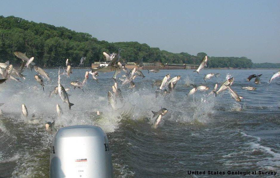
1 Investigating reproduction and abundance of bighead carp (Hypophthalmichthys nobilis) and silver carp (H. molitrix) in the Greenup pool, Ohio River Nathan Fleshman Dr. Thomas Jones Photo: USGS Photo: USGS

2 Bighead and Silver Carp Native to southern China and eastern Russia Introduced to the southern US in 1970s Kolar et al., 2007 Flooding aided their escape into MRB
3 Life History Filter feed up to 20% body weight daily Rapid growth rates (12+ inches in first year) High fecundity (50, ,000+ eggs per female) (Schrank and Guy 2002; Williamson and Garvey 2005) Tolerant Can travel great distances

4

5 61.8 miles long
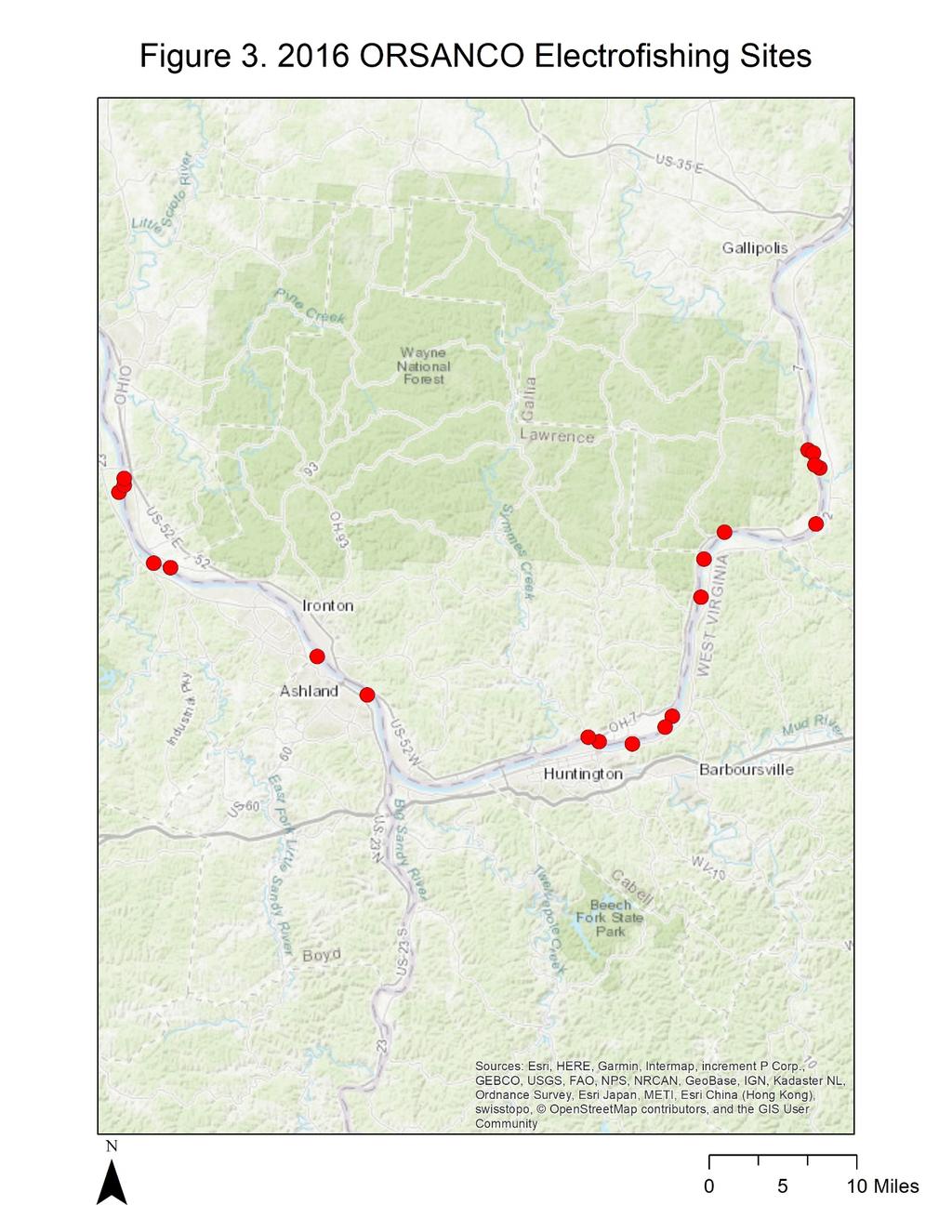
6 Objectives Investigate the relative abundance and reproductive potential of Asian carp in the Greenup pool Evaluate fish communities in the Greenup pool Build a historical record of the Greenup pool Compare netting methods
 5 in. mesh x 5.5 ft./17 ft. wide x 150 ft.")
7 Methods Gillnetting WVDNR Sites and Protocol (Ohio River Basin Asian Carp Control Strategy Framework) 5 in. mesh x 5.5 ft./17 ft. wide x 150 ft. long 2 hour sets w/ 5 minute runs every 30 minutes
8 Methods Gillnetting Experimental gill nets at ORSANCO electrofishing sites from 2011 and 2016 surveys Float line Flow 7.62cm wide Marker buoys Sampling 15 sites from each survey (30 sites total) Shore 2.43m deep 12 hour sets 2.54cm 5.08cm 7.62cm 10.15cm 12.70cm Anchor line Anchor

9

10 Methods Quatrefoil Light Traps Sets of 4 at ORSANCO sites (12 hours) 500 micron mesh Cyalume TM green 12-hour glowsticks In water 1m deep, spaced 5m apart
11 ORSANCO Fish Data 2006/2011/ Species Richness = 40 Total Abundance = 1, Species Richness = 47 Total Abundance = 4, Species Richness = 45 Total Abundance = 3,666
12 2006 Fish Diversity Black Buffalo Bluegill Bluntnose Minnow Brown Bullhead Channel Catfish Channel Darter Channel Shiner Common Carp Emerald Shiner Flathead Catfish Freshwater Drum Gizzard Shad Golden Redhorse Green Sunfish Highfin Carpsucker Largemouth Bass Logperch Longear Sunfish Longnose Gar Morone Sp Quillback Redear Sunfish River Carpsucker River Darter River Redhorse Sauger Silver Chub Silver Lamprey Silver Redhorse Slenderhead Darter Smallmouth Bass Smallmouth Buffalo Smallmouth Redhorse Spotfin Shiner Spotted Bass Spotted Sucker Striped Bass Walleye White Bass White Crappie
13 Black Buffalo Black Crappie Bluegill Bluntnose Minnow Bowfin Bullhead Minnow Channel Catfish Channel Shiner Common Carp Emerald Shiner Flathead Catfish Freshwater Drum Gizzard Shad Golden Redhorse Green Sunfish Hybrid Striper Largemouth Bass Lepomis Hybrid Lepomis sp Logperch Longear Sunfish Longear X Green Sunfish Longnose Gar Mooneye Morone Sp Moxostoma sp Northern Hog Sucker Orangespotted Sunfish Pumpkinseed Quillback Redear Sunfish River Carpsucker River Redhorse River Shiner Rock Bass Sauger Silver Chub Silver Redhorse Smallmouth Bass Smallmouth Buffalo Smallmouth Redhorse Spotfin Shiner Spotted Bass Spotted Sucker Walleye White Bass White Crappie 2011 Fish Diversity
14 Bigmouth Buffalo Black Buffalo Black Crappie Black Redhorse Bluegill Bluntnose Minnow Bullhead Minnow Channel Catfish Channel Darter Channel Shiner Common Carp Creek Chub Emerald Shiner Flathead Catfish Freshwater Drum Gizzard Shad Golden Redhorse Green Sunfish Highfin Carpsucker Hybrid Striper Largemouth Bass Logperch Longear Sunfish Longnose Gar Micropterus sp Mooneye Morone Sp Northern Hog Sucker Orangespotted Sunfish Paddlefish Quillback Redear Sunfish River Carpsucker River Redhorse River Shiner Sauger Silver Chub Silver Lamprey Silver Redhorse Smallmouth Bass Smallmouth Buffalo Smallmouth Redhorse Spotfin Shiner Spottail Shiner Spotted Bass Spotted Sucker White Bass White Crappie 2016 Fish Diversity
15 Phelps et al Table 3 A qualitative comparison of change in fish communities within floodplain lakes. Phelps et al Silver Carp negatively affect Bigmouth Buffalo and Gizzard Shad Both exhibited decreased relative abundance and condition in response to increased Silver Carp relative abundance
16 Unpublished Data Dashields Pool 112 fish of 20 species were captured during 217 net hours RC Byrd Pool 75 fish of 17 species were captured during 69 net hours Cumulative species Cumulative species Species Area Curve Dashields Pool Net Hour Species Area Curve RC Byrd Pool Net Hour
17 Length-Weight Relationships When there are more than 10 fish of the same species the trend lines have shown good fit (R 2 >0.84) Weight (g) Length Weight Relationship for Smallmouth Buffalo in the RC Byrd Pool R² = Total Length (mm)
18
19 References Kolar CS, Chapman DC, Courtenay Jr WR and Jennings DP Asian Carps of the Genus Hypophthalmichthys (Pisces,Cyprinidae) a Biological Synopsis and Risk Assessment. American Fisheries society. Bathesda, MD USA. Marchetti MP, Esteban E, Limm M, and Kurth R Evaluating Aspects of Larval Light Trap Bias and Specificity in the Northern Sacramento River System: Do Size and Color Matter? ORFMT (Ohio River Fisheries Management Team) Ohio River Basin Asian Carp Control Strategy Framework. Phelps QE, Tripp SJ, Bales KR, James D, Hrabik RA, and Herzog DP Incorporating basic and applied approaches to evaluate the effects of invasive Asian Carp on native fishes: A necessary first step for integrated pest management. PLoS ONE 12(9): e Schrank SJ, and Guy CS Age, growth, and gonadal characteristics of adult bighead carp, Hypophthalmichthys nobilis, in the lower Missouri River. Environmental Biology of Fishes 64: Williamson CJ, and Garvey JE Growth, Fecundity, and Diets of Newly Established Silver Carp in the Middle Mississippi River. Transactions of the American Fisheries Society,134(6),
20 Questions?
Lake St. Clair Fish Community and Fishery
 Lake St. Clair Fish Community and Fishery Megan Belore Ontario Ministry of Natural Resources and Forestry Mike Thomas Michigan Department of Natural Resources Fish Community Fish Community Mixture of warm
THE LONG-TERM ILLINOIS RIVER FISH POPULATION MONITORING PROGRAM
 T E C H N I C A L R E P O R T THE LONG-TERM ILLINOIS RIVER FISH POPULATION MONITORING PROGRAM Project F-101-R-20 Annual Report to the Illinois Department of Natural Resources Michael A. McClelland and
Thunder Bay River Assessment Appendix. Appendix 2
 Appendix 2 Known past and present fish distributions in the River system. Distribution of fishes were compiled from Bailey et al. (2003) and from records located at the Michigan Department of Natural Resources
Little Calumet River Rapid Response Fish Identification and Enumeration Branch Summary Report
 Little Calumet River Rapid Response Fish Identification and Enumeration Branch Summary Report Introduction A rotenone rapid response was completed on a 2.6-mile section of the Little Calumet River immediately
Penny Road Pond Population Survey
 Located in Barrington Hills on the south side of Penny Rd. west of Old Sutton Rd. This small 7 acre pond has a maximum depth of 4.6 feet and is connected to Spring Creek. The fish population of Penny Road
Big Bend Lake Population Survey
 Big Bend Lake Survey Located in Des Plaines on East River Rd. just south of Golf Rd. This 27 acre body of water has a depth of 27.8 feet; however because it is connected to the Des Plaines River by a spillway,
Great Lakes Coastal Wetland Communities: Vulnerabilities to Climate Change and Response to Adaptation Strategies
 Great Lakes Coastal Wetland Communities: Vulnerabilities to Climate Change and Response to Adaptation Strategies CCAF Wetlands Study Investigators: Susan Doka Fisheries & Oceans, Great Lakes Lab for Fisheries
Job 1 Part JOB 1, PART 2: SUMMARY OF CONOWINGO DAM WEST FISH LIFT OPERATIONS, 2009
 2.0 JOB 1, PART 2: SUMMARY OF CONOWINGO DAM WEST FISH LIFT OPERATIONS, 2009 Lawrence M. Miller Normandeau Associates U. S. Fish and Wildlife Service 1921 River Road Harrisburg, Pennsylvania Drumore, Pennsylvania
Rolling Knolls Pond Population Survey
 Located near the town of Elgin on the west side of Rohrssen Rd. between Illinois Route 58 and U.S.- 20. This small 1.8 acre pond has a maximum depth of 7.5 feet and is occasionally influenced by Poplar
INVASIVE CARP SAMPLING REPORT JANUARY DECEMBER 2016 MINNESOTA DEPARTMENT OF NATURAL RESOURCES DIVISION OF FISH AND WILDLIFE SECTION OF FISHERIES
 INVASIVE CARP SAMPLING REPORT JANUARY DECEMBER 2016 MINNESOTA DEPARTMENT OF NATURAL RESOURCES DIVISION OF FISH AND WILDLIFE SECTION OF FISHERIES UPPER MISSISSIPPI RIVER, POOLS 1-5 LOWER ST. CROIX RIVER,
The relationship between the spatial distribution of common carp and their environmental DNA in a small lake
 The relationship between the spatial distribution of common carp and their environmental DNA in a small lake Jessica Eichmiller*, Przemyslaw Bajer, and Peter Sorensen Department of Fisheries, Wildlife,
Quemahoning Reservoir
 Pennsylvania Fish & Boat Commission Biologist Report Quemahoning Reservoir Somerset County May 2011 Trap Net, Gill Net and Electrofishing Survey Quemahoning Reservoir is an 899 acre impoundment located
INVASIVE CARP SAMPLING REPORT JANUARY DECEMBER 2013 MINNESOTA DEPARTMENT OF NATURAL RESOURCES DIVISION OF FISH AND WILDLIFE SECTION OF FISHERIES
 INVASIVE CARP SAMPLING REPORT JANUARY DECEMBER 2013 MINNESOTA DEPARTMENT OF NATURAL RESOURCES DIVISION OF FISH AND WILDLIFE SECTION OF FISHERIES UPPER MISSISSIPPI RIVER, POOL 2 LOWER ST. CROIX RIVER, BELOW
Bode Lake - South Population Survey
 Bode Lake - South Survey Located in Hoffman Estates on the north side of Bode Rd. 1 mile west of Barrington Rd. Bode Lake is made up of two lakes along Poplar Creek; the larger and deeper Bode Lake South
Methods for Evaluating Shallow Water Habitat Restoration in the St. Clair River
 Methods for Evaluating Shallow Water Habitat Restoration in the St. Clair River Objectives Document fish use of restoration sites Spawning Presence of larvae, juvenile, and adult fish Quantify differences
SUMMARY REPORT FOR LAKE ST. MALO FISHERIES ASSESSMENT. Prepared for the St. Malo and District Wildlife Association
 SUMMARY REPORT FOR LAKE ST. MALO FISHERIES ASSESSMENT Prepared for the St. Malo and District Wildlife Association Presented by August 25, 2014 Study dates thus far: Date Tasks February 16 Fishing derby;
MISSISSIPPI LEGISLATURE REGULAR SESSION 2007
 MISSISSIPPI LEGISLATURE REGULAR SESSION 2007 By: Representative Robinson (84th) To: Wildlife, Fisheries and Parks HOUSE BILL NO. 911 (As Sent to Governor) 1 2 3 4 5 6 7 8 9 10 11 12 13 14 15 16 17 18 19
MISSISSIPPI MAKEOVER A Plan for Restoration, Just Around the Bend
 MISSISSIPPI MAKEOVER A Plan for Restoration, Just Around the Bend Interim Report Card 2013 Project coordinated by the Dakota County Soil and Water Conservation District and sponsored by the Minnesota Pollution
Elk Lake, Antrim and Grand Traverse counties T. 28, 29 N., R. 8, 9 W., Sec. many. Lake surveys. began at 40 feet
 Elk Lake, Antrim and Grand Traverse counties T. 28, 29 N., R. 8, 9 W., Sec. many Physical and chemical data surveyed August 1931 Temperature ( F) Secchi disk (feet) 9. 6 Surface 74 Bottom 45 PH 8.0 Thermocline
Busse Reservoir South Lateral Pool Population Survey
 Busse Reservoir South Lateral Pool Survey Located in Elk Grove Village south of Higgins Rd. between RT 53/I-290 and Arlington Heights Rd. Busse Reservoir is comprised of three pools making up a total of
SUMMARY OF CONOWINGO DAM WEST FISH LIFT OPERATIONS 2012
 SUMMARY OF CONOWINGO DAM WEST FISH LIFT OPERATIONS 2012 Michael L. Hendricks Pennsylvania Fish and Boat Commission 1735 Shiloh Rd. State College, Pa 16801 INTRODUCTION The shore-based trapping device at
REEL FACTS. Regulations. Limblines Fishing with limblines and set hooks is prohibited at Lake Washington.
 Lake Washington 19 REEL FACTS Nathan Aycock Fisheries Biologist NathanA@mdwfp.state.ms.us (61) 432-2 General Information: Lake Washington is a 3, acre oxbow lake of the Mississippi River. It is one of
Caro Impoundment, Tuscola County
 Caro Impoundment is a 200 acre impoundment of the Cass River located one mile south of the Village of Caro in Tuscola County. Caro Dam, originally constructed in 1906 for water supply to Michigan Sugar
Pearl River 2018 Middle Reach REEL FACTS Dustin Rodgers Fisheries Biologist
 Pearl River 1 Middle Reach REEL FACTS Dustin Rodgers Fisheries Biologist dustinr@mdwfp.state.ms.us General Information: The Pearl River contains the third largest drainage basin in Mississippi. A variety
LAKE DIANE Hillsdale County (T8-9S, R3W, Sections 34, 3, 4) Surveyed May Jeffrey J. Braunscheidel
 Surveyed May Jeffrey J. Braunscheidel") Michigan Department of Natural Resources Status of the Fishery Resource Report No. 2003-4, 2003 LAKE DIANE Hillsdale County (T8-9S, R3W, Sections 34, 3, 4) Surveyed May 2001 Jeffrey J. Braunscheidel Environment
Michigan Department of Natural Resources Status of the Fishery Resource Report No. 2003-4, 2003 LAKE DIANE Hillsdale County (T8-9S, R3W, Sections 34, 3, 4) Surveyed May 2001 Jeffrey J. Braunscheidel Environment
Schiller Pond Population Survey
 Located in the town of Schiller Park on Irving Park Rd. just west of Cumberland Ave. This small 6 acre pond has a maximum depth of 6.3 feet. In addition to largemouth bass and bluegill, Schiller Pond is
Sag Quarry - West Population Survey
 Located in Lemont on RT 83 and Archer Ave. just north of 111 th St. Like Sag Quarry East, this lake is an old limestone quarry, 14 acres in size and with a maximum depth of 10.3 feet. The species found
Fisheries Survey of Saratoga Lake
 Fisheries Survey of Saratoga Lake 7- Mark D. Cornwell Kevin Poole State University of New York College of Agriculture & Technology Department of Fisheries & Wildlife Cobleskill, NY ABSTRACT: This survey
An Assessment of the Fish Community in Lake Acworth
 An Assessment of the Fish Community in Lake Acworth By John Damer Fisheries Biologist Georgia Department of Natural Resources Wildlife Resources Division Fisheries Section Calhoun, GA 30701 July 2008 Introduction
Moon Lake 2019 REEL FACTS Nathan Aycock - Fisheries Biologist (601)
") Moon Lake 19 REEL FACTS Nathan Aycock - Fisheries Biologist NathanA@mdwfp.state.ms.us (61) 43- General Information: Moon Lake is a,3 acre oxbow lake of the Mississippi River. The primary inflow to the
Moon Lake 19 REEL FACTS Nathan Aycock - Fisheries Biologist NathanA@mdwfp.state.ms.us (61) 43- General Information: Moon Lake is a,3 acre oxbow lake of the Mississippi River. The primary inflow to the
Onondaga Lake Fishery: 2011 Fact Sheet
 October, 2011 Onondaga County Department of Water Environment Protection SUNY College of Environmental Science and Forestry Joanne M. Mahoney, County Executive Tom Rhoads, P.E., Commissioner Onondaga Lake
Moon Lake 2018 REEL FACTS Nathan Aycock - Fisheries Biologist (601)
") Moon Lake 18 REEL FACTS Nathan Aycock - Fisheries Biologist NathanA@mdwfp.state.ms.us (61) 43- General Information: Moon Lake is a,3 acre oxbow lake of the Mississippi River. The primary inflow to the
Moon Lake 18 REEL FACTS Nathan Aycock - Fisheries Biologist NathanA@mdwfp.state.ms.us (61) 43- General Information: Moon Lake is a,3 acre oxbow lake of the Mississippi River. The primary inflow to the
I L L I N 0 PRODUCTION NOTE. University of Illinois at Urbana-Champaign Library Large-scale Digitization Project, 2007.
 I L L I N S UNIVERSITY OF ILLINOIS AT URBA-CHAMPAIGN PRODUCTION NOTE University of Illinois at Urbana-Champaign Library Large-scale Digitization Project, 7. Uf'HS cft, Natural History Survey Library Illinois
Alcona Dam Pond Alcona County (T25N, R5E, Sections various) Surveyed June 6-12 and September 16, 2003
 Surveyed June 6-12 and September 16, 2003") Michigan Department of Natural Resources Status of the Fishery Resource Report No. 2004-6, Year 2004 Alcona Dam Pond Alcona County (T25N, R5E, Sections various) Surveyed June 6-12 and September 16, 2003
Michigan Department of Natural Resources Status of the Fishery Resource Report No. 2004-6, Year 2004 Alcona Dam Pond Alcona County (T25N, R5E, Sections various) Surveyed June 6-12 and September 16, 2003
Introduction: JadEco, LLC PO BOX 445 Shannon, IL 61078
 Introduction: was contacted to collected data on the fishery for Lake Holiday. AC Electroshocking was conducted at 2 locations on September 28, 2015. Fish population data was collected for a total of 100
Pickwick Lake 2018 REEL FACTS Trevor Knight Fisheries Biologist (662)
") Pickwick Lake 218 REEL FACTS Trevor Knight Fisheries Biologist trevork@mdwfp.state.ms.us (662) 84-5176 General Information: Covering 43,1 acres, Pickwick Lake, which borders Alabama, Tennessee, and Mississippi,
Pickwick Lake 218 REEL FACTS Trevor Knight Fisheries Biologist trevork@mdwfp.state.ms.us (662) 84-5176 General Information: Covering 43,1 acres, Pickwick Lake, which borders Alabama, Tennessee, and Mississippi,
JadEco, LLC PO BOX 445 Shannon, IL 61078
 Introduction: With the assistance of Lake Holiday staff and volunteers, we were able to conduct an AC electrofishing survey on May 8, 27. Water temperatures were 2.3 C (8.5 F) and water clarity was decent
O&Mbuited Gwk k Fu\m w Kowm. Tke [Iwvmty $ Komm ftfwewtt o( HahmJt Hufottj cud State BfoCogM Suwey
 O&Mbuited Gwk k Fu\m w Kowm Tke [Iwvmty $ Komm ftfwewtt o( HahmJt Hufottj cud State BfoCogM Suwey UNIVERSITY OF KANSAS PUBLICATIONS MUSEUM OF NATURAL HISTORY The Public Education Series is intended to
JOB 1, PART 2. SUMMARY OF CONOWINGO DAM WEST FISH LIFT OPERATIONS 2011
 JOB 1, PART 2. SUMMARY OF CONOWINGO DAM WEST FISH LIFT OPERATIONS 2011 Michael L. Hendricks Pennsylvania Fish and Boat Commission 1735 Shiloh Rd. State College, Pa 16801 INTRODUCTION The shore-based trapping
Rat Cove and Brookwood Point littoral fish survey, 2002
 Rat Cove and Brookwood Point littoral fish survey, 2 Katie Wayman 1 INTRODUCTION During the summer of 2, efforts to monitor the Otsego Lake littoral fish community continued with trap netting at both Rat
I L L I N 0 I S PRODUCTION NOTE. University of Illinois at Urbana-Champaign Library Large-scale Digitization Project, 2007.
 I L L I N I S UNIVERSITY OF ILLINOIS AT URBANA-CHAMPAIGN PRODUCTION NOTE University of Illinois at Urbana-Champaign Library Large-scale Digitization Project, 7. ILLINOIS NT A TITD A I LIIC T'tRDY i- U
HOT SPRINGS VILLAGE LAKES
 HOT SPRINGS VILLAGE LAKES BILL STAGGS PUBLIC WORKS DIRECTOR BRADLEY J. MEREDITH LAKES ECOLOGY & FISHERIES MANAGER Photos by Bradley J. Meredith and Katy Harmon LAKES IMPROVEMENT PLAN STAFFING CAPITAL IMPROVEMENTS
BA1 BA2 BA3 BA4 BA5 BA6 CP1 CP2 CP3 CP4 CP5 CP6
 Table 1: Results of fish collections within or adjacent to the Boyne Secondary Plan Area conducted by C. Portt and Associates. Station locations are provided in Figure 1. Stations BA1-BA6 were collected
Delaware River Seine Survey: 2012 Sampling Summary
 Delaware River Seine Survey: 2012 Sampling Summary Fish and Wildlife employees pull in the seine net From June 18 to November 21, 2012, biologists conducted the Delaware River Seine Survey. Over the course
Fish community assessment in the Harpeth River prior to the removal of the dam at Franklin, TN
 Fish community assessment in the Harpeth River prior to the removal of the dam at Franklin, TN Submitted to Dorie Bolze, Harpeth River Watershed Association By Frank Fiss and Nathan Singer, Tennessee Wildlife
Tahquamenon River Assessment Appendix
 DNR DEPARTMENT OF NATURAL RESOURCES MICHIGAN STATE OF MICHIGAN DEPARTMENT OF NATURAL RESOURCES SR45 Appendix February 2008 Tahquamenon River Assessment Appendix James R. Waybrant and Troy G. Zorn www.michigan.gov/dnr/
McGinty Slough Population Survey
 Located in Lemont, north of 131 st St and west of Will-Cook Rd. and is 38 acres with a depth of 8.2 feet. This lake is walk in access only, to access the lake walk the multi-use trail ether from 131 st
Maple Lake Population Survey
 Maple Lake Survey Located in Willow Springs approximately 1 mile west of Willow Springs Rd. (104 th Ave.) at Wolf Rd. and 95 th St. Constructed in the 1920 s this 60 acre lake drops down to 20.4 feet in
Tampier Lake Population Survey
 Located in Palos Park on 131 st St. between Wolf and Will-Cook Rd. s. Tampier Lake has 131 acres of fishable water, with a maximum depth of 9.4 feet. Walleye, northern pike, largemouth bass and channel
Wampum Lake Population Survey
 Wampum Lake Survey Located in Thornton on Thornton-Lansing Rd. 1½ mile west of Torrence Ave. Wampum Lake is 35 acres is size and has a maximum depth of 14.1 feet. Northern pike, largemouth bass, bluegill,
Arizona Game and Fish Department Region VI Fisheries Program
 Arizona Game and Fish Department Region VI Fisheries Program Saguaro Lake Fish Survey Report April 18 th 21 st, 2016 Author: Bryant Dickens Report Date: July 7, 2016 The Arizona Game and Fish Department
Conewago Creek Initiative. Fish Survey Report for the Conewago Creek
 Conewago Creek Initiative Fish Survey Report for the Conewago Creek A compilation of historic fish survey data from 97, 973, 7, for three locations along the Conewago Creek Prepared by Kristen Kyler for
2010 Fishing Opener Prognosis. Central Region
 2010 Fishing Opener Prognosis Central Region Hinckley PINE COUNTY Pokegama, Cross, Island, Oak and North and South Big Pine Lakes are typically the best lakes for targeting walleye in Pine County. They
S UNIVERSITY OF ILLINOIS AT URBANA-CHAMPAIGN
 ILLINOI S UNIVERSITY OF ILLINOIS AT URBANA-CHAMPAIGN PRODUCTION NOTE University of Illinois at Urbana-Champaign Library Large-scale Digitization Project, 2007. NATURAL HISTORY ILLINOIS t T A nr "ru Ar'Im
MIDDLE FORK RESERVOIR Wayne County 2004 Fish Management Report. Christopher C. Long Assistant Fisheries Biologist
 MIDDLE FORK RESERVOIR Wayne County 2004 Fish Management Report Christopher C. Long Assistant Fisheries Biologist FISHERIES SECTION INDIANA DEPARTMENT OF NATURAL RESOURCES DIVISION OF FISH AND WILDLIFE
SKIATOOK LAKE MANAGEMENT PLAN
 SKIATOOK LAKE MANAGEMENT PLAN Background Skiatook Lake impounds Hominy Creek, 5 miles west of Skiatook in Osage County, Oklahoma (Figure 1). Skiatook Lake covers 10,540 surface acres and was constructed
Rouge Fish Surveys
 Rouge Fish Surveys 2011-16 Friends of the Rouge January 2017 Partially funded by the Areas of Concern Program Office of the Great Lakes (OGL), DEQ Additional data provided by MDNR and MDEQ Fall 2016 Sampling
Indiana Administrative Code Page IAC Aquaculture permit Authority: IC Affected: IC Sec. 17. (a) A person must not
 A person must not") Indiana Administrative Code Page 71 312 IAC 9-10-17 Aquaculture permit Affected: IC 14-22-27 Sec. 17. (a) A person must not import, raise, sell, or transport fish into or within Indiana without an aquaculture
Indiana Administrative Code Page 71 312 IAC 9-10-17 Aquaculture permit Affected: IC 14-22-27 Sec. 17. (a) A person must not import, raise, sell, or transport fish into or within Indiana without an aquaculture
Profile of the Current Non-Asian Carp Commercial Fishing Industry on the Illinois River
 Profile of the Current Non-Asian Carp Commercial Fishing Industry on the Illinois River Rob Maher Illinois Department of Natural Resources Division of Fisheries Commercial Fishing Project Manager Historic
EVALUATION OF THE FISH COMMUNITY AND GAME FISH POPULATIONS IN SUGAR CREEK (MONTGOMERY AND PARKE COUNTIES)
") EVALUATION OF THE FISH COMMUNITY AND GAME FISH POPULATIONS IN SUGAR CREEK (MONTGOMERY AND PARKE COUNTIES) 2000 Fish Management Report Douglas C. Keller Fisheries Biologist FISHERIES SECTION INDIANA DEPARTMENT
EVALUATION OF THE FISH COMMUNITY AND GAME FISH POPULATIONS IN SUGAR CREEK (MONTGOMERY AND PARKE COUNTIES) 2000 Fish Management Report Douglas C. Keller Fisheries Biologist FISHERIES SECTION INDIANA DEPARTMENT
Tunica Cutoff 2018 REEL FACTS Keith Meals Fisheries Biologist
 Tunica Cutoff 218 REEL FACTS Keith Meals Fisheries Biologist keithm@mdwfp.state.ms.us General Information: Tunica Cutoff was created by the US Army Corps of Engineers (COE) in 1942 when a bend in the Mississippi
Archer Lake 2011 Survey Report Prepared by Brian Gunderman
 Archer Lake 211 Survey Report Prepared by Brian Gunderman Introduction Archer Lake is a 64 acre lake located about miles southeast of the city of Coldwater. Archer Lake is part of the Coldwater-Marble
Regulations. Grabbling season May 1 July 15; only wooden structures allowed.
 Enid Reservoir 218 REEL FACTS Keith Meals, Arthur Dunn, Stanley Turner Fisheries Biologists keithm@mdwfp.state.ms.us, ArthurD@mdwfp.state.ms.us, StanleyT@mdwfp.state.ms.us General Information: Enid Reservoir
Green Lake Population Survey
 Located next to the Green Lake Aquatic Center in Calumet City on the north side of 159 th St, east of Torrence Ave. Size can be deceiving; this 5 acre lake is the deepest lake in the District with a maximum
FINAL PERFORMANCE REPORT
 FINAL PERFORMANCE REPORT Federal Aid Grant No. F13AF01308 (T-70-1) An Assessment of Impacts of Bighead Carp on Species of Greatest Conservation Need in the Neosho and Spring Rivers Oklahoma Department
Ross Barnett Reservoir 2019
 Ross Barnett Reservoir 19 Reel Facts Ryan Jones Fisheries Biologist Ryan.Jones@wfp.ms.gov (1) 89-31 General Information: Ross Barnett Reservoir is a 33, acre impoundment of the Pearl River. It consists
Tips for Identifying Common Fish Species in the Bush River
 Tips for Identifying Common Fish Species in the Bush River Juvenile Largemouth bass Spot Threadfin shad Juvenile White perch The Herrings (Family Clupeidae) Alewife American shad Blueback herring Atlantic
STUDY PERFORMANCE REPORT
 STUDY PERFORMANCE REPORT State: Michigan Project No.: F-81-R-6 Study No.: 230695 Title: Northern Lake Huron, coolwater fish community assessment. Period Covered: October 1, 2004 to September 30, 2005 Study
Regulations. Grabbling season May 1 July 15; only wooden structures allowed.
 Arkabutla Reservoir 219 REEL FACTS Keith Meals, Arthur Dunn, Stanley Turner Fisheries Biologists keithm@wfp.ms.gov, ArthurD@wfp.ms.gov, StanleyT@wfp.ms.gov General Information: Arkabutla Reservoir is one
May Biological and Habitat Study of the Olentangy River, 2005 and City of Delaware Dam Removals
 May 2010 Biological and Habitat Study of the Olentangy River, 2005 and 2009 City of Delaware Dam Removals HUC 05060001 10 07 Delaware Run-Olentangy River Delaware County, Ohio OHIO EPA Technical Report
Waubee Lake Kosciusko County Fish Management Report 2006
 Waubee Lake Kosciusko County Fish Management Report 2006 Jed Pearson, fisheries biologist Fisheries Section Indiana Department of Natural Resources Division of Fish and Wildlife I.G.C.-South, Room W273
Fisheries Survey of White Rapids Flowage, Marinette County Wisconsin during Waterbody Identification Code
 Fisheries Survey of White Rapids Flowage, Marinette County Wisconsin during 25 Waterbody Identification Code 6343 Michael Donofrio Fisheries Supervisor Wisconsin Department of Natural Resources Peshtigo,
Arrowhead Lake Population Survey
 Located in Palos Heights at 135 th St, east of Harlem Ave. Arrowhead Lake is a 13 acre body of water with a maximum depth of 12.6 feet. Fish species found in this lake include largemouth bass, bluegill,
Proposed Changes to Bag and Size Limits Minnesota/Wisconsin Border Waters of the Mississippi River
 Proposed Changes to Bag and Size Limits Minnesota/Wisconsin Border Waters of the Mississippi River The Minnesota and Wisconsin DNRs are jointly reviewing fishing regulations on Pools 3-9 of the Mississippi
Pennsylvania Fish & Boat Commission Biologist Report. Wilmore Dam. Cambria County. May 2011 Trap Net, Electrofishing and Hoop Net Survey
 Pennsylvania Fish & Boat Commission Biologist Report Wilmore Dam Cambria County May 2011 Trap Net, Electrofishing and Hoop Net Survey Wilmore Dam is a 195 acre impoundment located in central Cambria County
Regulations. Grabbling season May 1 July 15; only wooden structures allowed.
 Sardis Reservoir 218 REEL FACTS Keith Meals, Arthur Dunn, Stanley Turner Fisheries Biologists keithm@mdwfp.state.ms.us, ArthurD@mdwfp.state.ms.us, StanleyT@mdwfp.state.ms.us General Information: Sardis
Conewago Creek Initiative
 Conewago Creek Initiative The Conewago Creek Revisited Fish Survey Report A compilation of historic fish survey data from 197, 1973, 7, 1, and 15 for three locations along the Conewago Creek Prepared by
Fish Survey of Goose Lake (ID # ), Ramsey County, Minnesota in 2012
, Ramsey County, Minnesota in 2012") Softshell Turtle from Goose Lake, July 2012 Fish Survey of Goose Lake (ID #62-0034), Ramsey County, Minnesota in 2012 Survey Dates: July 16-18, 2012 MnDNR Permit Number: 18362 Prepared for: VLAWMO and
Softshell Turtle from Goose Lake, July 2012 Fish Survey of Goose Lake (ID #62-0034), Ramsey County, Minnesota in 2012 Survey Dates: July 16-18, 2012 MnDNR Permit Number: 18362 Prepared for: VLAWMO and
Michigan Dept. of Natural Resources Status of the Fishery Resource Report Page 1
 Michigan Dept. of Natural Resources 2012-132 Status of the Fishery Resource Report Page 1 Hamlin Lake Mason County Big Sable River watershed, surveyed 2010 Mark A. Tonello, Senior Fisheries Biologist,
Lake information report
 Lake information report: Minnesota DNR Page of 5 Lake information report jf Prinlable senior Name: Spring Nearest Town: Spring Lake (Scott) Primary County: Scott Survey Date: 08/02/200 Inventory Number:
10000 Bluntnose minnow. White sucker Blacknose shiner. Northern pike Carp Silver shiner Tadpole madtom
 10000 Bluntnose minnow Common shiner umber of individuals 1000 100 potfin shiner chub hite sucker Blacknose shiner Bluegill Blacknose dace Hornyhead chub Rock bass and shiner chub pottail shiner Golden
LAKE ONTARIO FISH COMMUNITIES AND FISHERIES: 2013 ANNUAL REPORT OF THE LAKE ONTARIO MANAGEMENT UNIT
 LAKE ONTARIO FISH COMMUNITIES AND FISHERIES: 2013 ANNUAL REPORT OF THE LAKE ONTARIO MANAGEMENT UNIT LAKE ONTARIO FISH COMMUNITIES AND FISHERIES: 2013 ANNUAL REPORT OF THE LAKE ONTARIO MANAGEMENT UNIT
HUBBARD LAKE Alcona County (T27N, R7E; T28N, R7E) Surveyed May and September Tim A. Cwalinski
 Surveyed May and September Tim A. Cwalinski") Michigan Department of Natural Resources Status of the Fishery Resource Report No. 2003-1, 2003 HUBBARD LAKE Alcona County (T27N, R7E; T28N, R7E) Surveyed May and September 1996 Tim A. Cwalinski Environment
Michigan Department of Natural Resources Status of the Fishery Resource Report No. 2003-1, 2003 HUBBARD LAKE Alcona County (T27N, R7E; T28N, R7E) Surveyed May and September 1996 Tim A. Cwalinski Environment
Rob Tewes Senior Aquatic Biologist; ORSANCO. The Ohio River Valley Water Sanitation Commission (ORSANCO) Biological and Research Programs
 Biological and Research Programs") Rob Tewes Senior Aquatic Biologist; ORSANCO Background The Ohio River has been subject to invasions from exotic aquatic species since at least the mid to late 1800 s when Common Carp began gaining a foot-hold
Rob Tewes Senior Aquatic Biologist; ORSANCO Background The Ohio River has been subject to invasions from exotic aquatic species since at least the mid to late 1800 s when Common Carp began gaining a foot-hold
Cedar Lake Comprehensive Survey Report Steve Hogler and Steve Surendonk WDNR-Mishicot
 Cedar Lake- 2006 Comprehensive Survey Report Steve Hogler and Steve Surendonk WDNR-Mishicot ABSTRACT Cedar Lake is a 142 acre lake located in the southwest corner of Manitowoc County. It is a seepage lake
Ross Barnett Reservoir 2018
 Ross Barnett Reservoir 18 Reel Facts Ryan Jones Fisheries Biologist Ryanj@mdwfp.state.ms.us (61) 89-341 General Information: Ross Barnett Reservoir is a 33, acre impoundment of the Pearl River. It consists
Regulations. Grabbling season May 1 July 15; only wooden structures allowed.
 Sardis Reservoir 19 REEL FACTS Keith Meals, Arthur Dunn, Stanley Turner Fisheries Biologists keithm@wfp.ms.gov, ArthurD@wfp.ms.gov, StanleyT@wfp.ms.gov General Information: Sardis Reservoir is one of four
Lake Butte des Morts Commercial Seining Project Report
 Lake Butte des Morts Commercial Seining Project Report Adam Nickel, Winnebago Gamefish (excluding sturgeon) Biologist, 22 December 2014 Conducting comprehensive fish surveys on the Upriver Lakes, including
Michigan Dept. of Natural Resources Status of the Fishery Resource Report Page 1. Weber Lake Cheboygan County, T34N, R3W, Sec.
 Michigan Dept. of Natural Resources 2012-143 Status of the Fishery Resource Report Page 1 Weber Lake Cheboygan County, T34N, R3W, Sec. 31 Neal Godby, Fisheries Biologist Environment Weber Lake is a 28.5-acre
MARTINDALE POND Wayne County 2004 Fish Management Report. Christopher C. Long Assistant Fisheries Biologist
 MARTINDALE POND Wayne County 2004 Fish Management Report Christopher C. Long Assistant Fisheries Biologist Fisheries Section Indiana Department of Natural Resources Division of Fish and Wildlife I.G.C.
Lake Ontario Fish Communities and Fisheries: 2017 Annual Report of the Lake Ontario Management Unit
 Lake Ontario Fish Communities and Fisheries: 2017 Annual Report of the Lake Ontario Management Unit Cover Photos: (Left) MNRF s Ontario Explorer on Lake Ontario (Right top) Walleye equipped with acoustic
Regulations. Grabbling season May 1 July 15; only wooden structures allowed.
 Grenada Reservoir 218 REEL FACTS Keith Meals, Arthur Dunn, Stanley Turner Fisheries Biologists keithm@mdwfp.state.ms.us, ArthurD@mdwfp.state.ms.us, StanleyT@mdwfp.state.ms.us General Information: Grenada
Three Rivers Smallmouth Bass, Walleye, and Sauger Southwestern Pennsylvania
 Pennsylvania Fish & Boat Commission Biologist Report Three Rivers Smallmouth Bass, Walleye, and Sauger Southwestern Pennsylvania June 2011 Dams Tailwaters Surveys The Three Rivers are a greatly altered
STUDY PERFORMANCE REPORT
 STUDY PERFORMANCE REPORT State: Michigan Project No.: F-81-R-5 Study No.: 230466 Title: Fish community status in Saginaw Bay, Lake Huron Period Covered: October 1, 2003 to September 30, 2004 Study Objective:
Pascagoula River Marsh 2018 REEL FACTS Stephen Brown Fisheries Biologist
 Pascagoula River Marsh 218 REEL FACTS Stephen Brown Fisheries Biologist stephenb@mdwfp.state.ms.us General Information: The Pascagoula River marsh is 25 acres of tidal creeks, canals, bays, and streams
Lake Ontario Fish Communities and Fisheries: 2016 Annual Report of the Lake Ontario Management Unit
 Lake Ontario Fish Communities and Fisheries: 216 Annual Report of the Lake Ontario Management Unit Cover Photos: (Left) MNRF s Ontario Explorer departing the Toronto Harbour, July 17, 216 (Right top) Ontario
Trip Report: Eagle Creek, Arizona
 Trip Report: Eagle Creek, Arizona 15-17 June 2009 Participants: Abraham Karam, Brian Kesner, and Mike Childs Native Fish Lab Marsh & Associates, LLC 5016 South Ash Avenue Suite 108 Tempe, Arizona 85282
FISH COMMUNITIES AND FISHERIES OF THE THOUSAND ISLANDS AND MIDDLE CORRIDOR
 St. Lawrence River Discussion Paper FISH COMMUNITIES AND FISHERIES OF THE THOUSAND ISLANDS AND MIDDLE CORRIDOR Issues Below is a synopsis of fish community issues and proposed management approaches. More
NEVADA DEPARTMENT OF WILDLIFE STATEWIDE SPORT FISHERIES MANAGEMENT
 NEVADA DEPARTMENT OF WILDLIFE STATEWIDE SPORT FISHERIES MANAGEMENT FEDERAL AID JOB PROGRESS REPORT F-20-50 2014 Urban Sport Fisheries SOUTHERN REGION NEVADA DEPARTMENT OF WILDLIFE, FISHERIES DIVISION ANNUAL
Fish Communities in Five West Coast Spring-fed Rivers. Brandon Simcox, Eric Johnson, Amanda Schworm, Bill Pouder
 Fish Communities in Five West Coast Spring-fed Rivers Brandon Simcox, Eric Johnson, Amanda Schworm, Bill Pouder Project Overview FWC/SWFWMD partnership 3-yr funded project (thru June 2017) 5 spring-fed