Methods for Evaluating Shallow Water Habitat Restoration in the St. Clair River
|
|
|
- Lucy Lawrence
- 5 years ago
- Views:
Transcription


1 Methods for Evaluating Shallow Water Habitat Restoration in the St. Clair River
2 Objectives Document fish use of restoration sites Spawning Presence of larvae, juvenile, and adult fish Quantify differences between restoration and control sites Species abundances and composition Juvenile fish abundance
3 ConnectingChannels Multiple Uses St. Marys River Economic, Ecological, and Societal Value St. Lawrence River St. Clair- Detroit River System Niagara River


4 Habitat Loss In The St. Clair River Riparian Development Dimitry Gorsky- USFWS Channelization


5 Impacts to Fish Loss of low velocity shallow water riparian habitat Nursery areas for developing fishes Habitat for small fishes Largemouth Bass Burbot Smallmouth Bass Bluegill Credit: City of Marysville
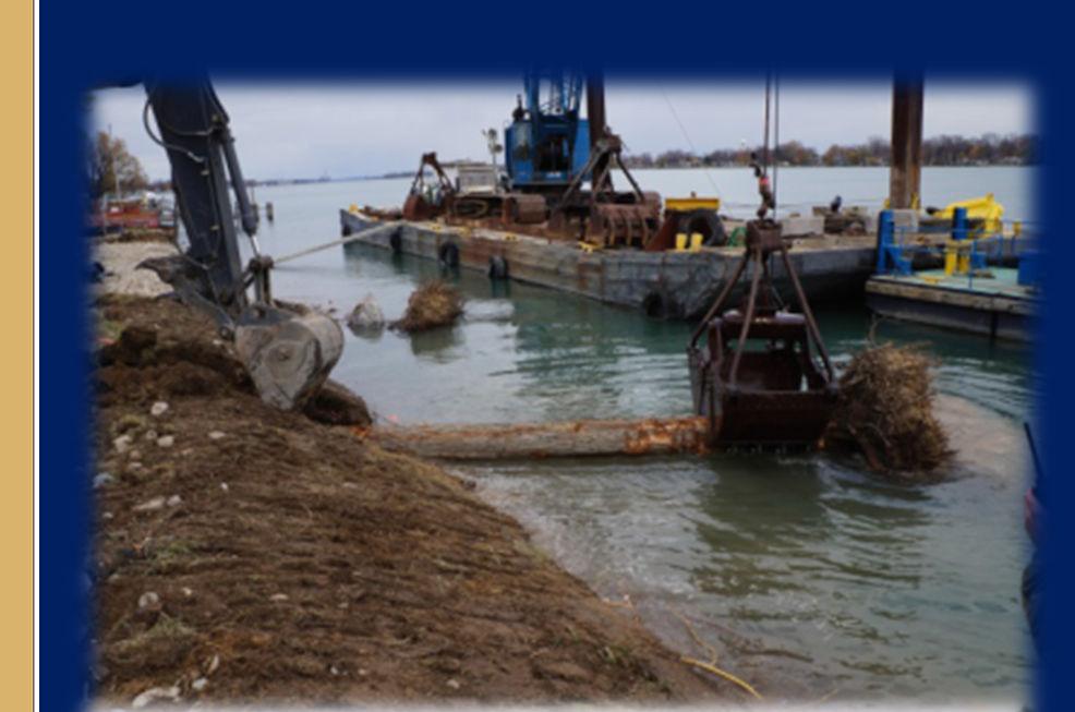
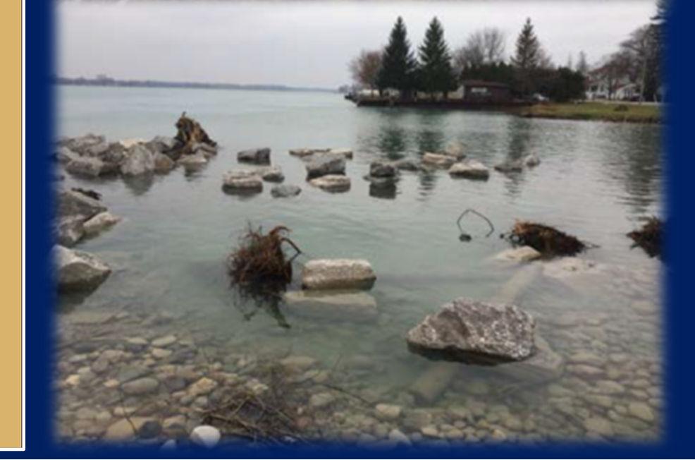
6 Shoreline Restoration


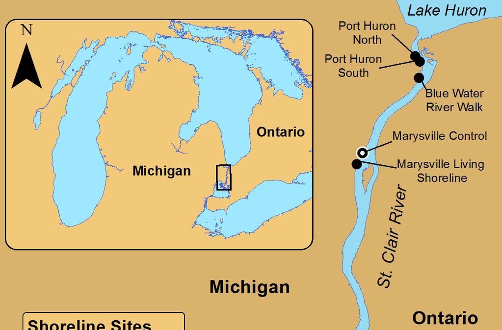
7 NearshoreRestoration Sites Port Huron North 93m of shoreline Mixed rock added Native shrubs and grasses planted Port Huron South 150m of shoreline Seawall removed Large woody debris added


8 NearshoreRestoration Sites Blue Water River Walk 1,300m of shoreline softened Mixed rock and large woody debris added Native plants and river walk incorporated Pumping for Fish Eggs Marysville Living Shoreline 400m of shoreline softened Mixed rock and large woody debris added Native plants and river walk incorporated


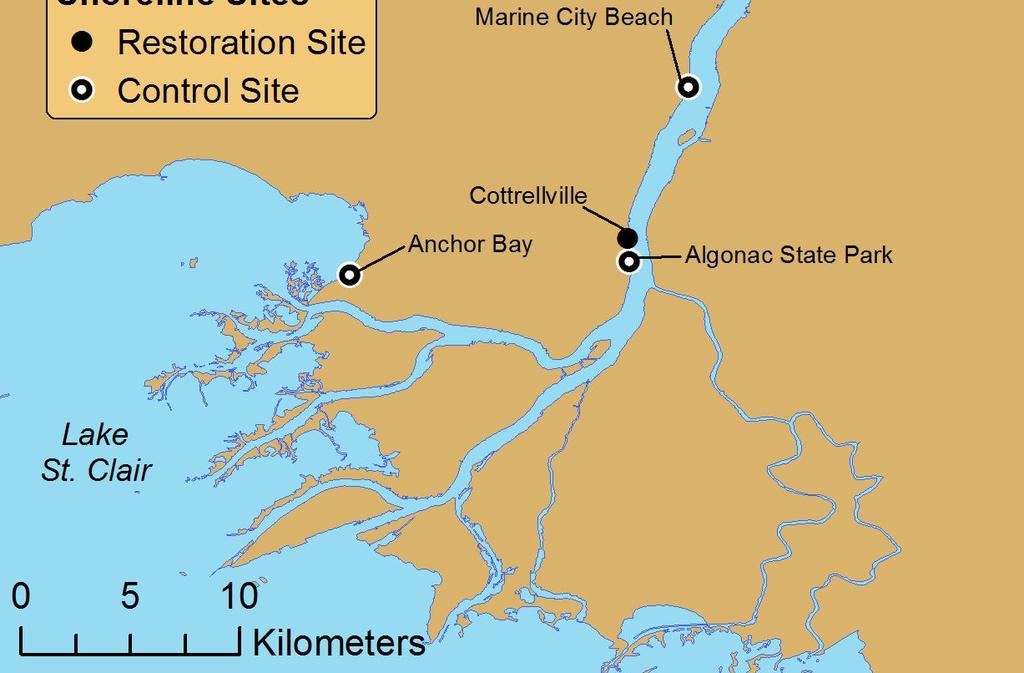
9 NearshoreRestoration Sites Cottrellville 152 m of shoreline softened Cobble and large woody debris added Native shrubs and grasses planted

10 Restoration Objectives Provide: Nursery habitat Habitat for small fishes Are they working? Limited pre-restoration data Community level assessment Assess multiple life stages


11 NearshoreControl Sites Shallow water areas with public access Mixture of riprap and sandy shoreline Marysville Control Marine City Beach Algonac State Park


12 Assessment Techniques Eggs Egg mats Egg pumping Larvae Light traps Larval Fish Light Traps Processing Light Traps Setting Egg Mats

13 Assessment Techniques Small and juvenile fishes Minnow traps Backpack Electrofishing Adult fishes Gillnets Processing Minnow Traps Minnow Trap Backpack Electrofishing Setting Gillnet
14 Sampling Limitations Site Egg Mat Egg Pump Light Trap Minnow Trap Port Huron North x x x x Port Huron South x x Backpack Electrofishing Gillnet Blue Water River Walk x x x x x x Marysville Control x x x x Marysville Living Shoreline Marine City Beach x x x x x x Cottrellville x x x x x x Algonac State Park x x x x x Anchor Bay x x x


15 Eggs and Larvae Egg mats and pumping 3 seasons Over 300 samples 11 eggs collected Light traps 2-4 fish families observed Catch dominated by gobies


16 Fish Use Of Restoration Sites Rainbow Darter Pugnose Minnow Brown Trout Rainbow Trout Mudpuppy
17 More Species Captured With Backpack Electrofishing Restoration Site Control Site Minnow Trap Gillnet Backpack Electrofishing


18 Quantifying Differences 1. Do species abundances differ between restoration and control sites? 2. Does species composition differ between site types? 3. Does juvenile abundance differ between site types? GALLERY.NANFA.ORG
19 Species and Groups of Interest SCDRS Initiative indicator species and groups Suckers Non-native species Rare, threatened, endangered (RTE) species Smallmouth bass Yellow perch Species, genera, families Based on number of individuals collected Adults and juveniles
 Yellow perch (Adult) Panfish(Adult & Juv.) Minnows Darters Mottled sculpin Other species Non-native species Yellow Perch Panfish(Juv.")
20 Species and Groups of Interest Electrofishing Minnow Traps Gillnets Suckers Non-native species RTE species Smallmouth bass (Juv.) Yellow perch (Adult) Panfish(Adult & Juv.) Minnows Darters Mottled sculpin Other species Non-native species Yellow Perch Panfish(Juv.) Minnows Other species Suckers Yellow perch (Adult) Other species
 Effort accounted for within model Allows relative abundance estimates Assess species")
21 Statistical Models Generalized linear models: Similar to ANOVA Poisson distribution Count data Inference on catch per unit effort (CPUE) Effort accounted for within model Allows relative abundance estimates Assess species composition
 Yellow perch (Adult) Panfish(Adult & Juv.")
22 Species and Groups of Interest Electrofishing Suckers Non-native species RTE species Smallmouth bass (Juv.) Yellow perch (Adult) Panfish(Adult & Juv.) Minnows Darters Mottled sculpin Other species Backpack Electrofishing
23 Greater CPUE at Restoration Sites Backpack Electrofishing
24 Greater CPUE at Restoration Sites Backpack Electrofishing
25 Assessing Species Composition Species CPUE Total CPUE Relative Abundance
26 Difference in Relative Abundances Backpack Electrofishing <- Control Restoration ->
27 Difference in Relative Abundances Backpack Electrofishing <- Control Restoration ->

28 Species and Groups of Interest Minnow Traps Non-native species Yellow Perch Panfish(Juv.) Minnows Other species Minnow Trap
29 Similar Abundances at Between Site Types Minnow Trap CPUE Relative Abundance
 Other species")
30 Species and Groups of Interest Gillnets Suckers Yellow perch (Adult) Other species Gillnets
31 Similar Abundances at Between Site Types Gillnets CPUE Relative Abundance
32 Quantifying Differences 1. Do species abundances differ between restoration and control sites? 2. Does species composition differ between site types? 3. Does juvenile abundance differ between site types? GALLERY.NANFA.ORG


33 Are Juvenile Fishes More Abundant at Restoration Sites? Native juvenile fishes pooled Differences assessed with Poisson models
34 Conclusions Backpack electrofishing most effective at sampling structurally complex habitats Higher resolution and power to detect differences More individuals and species collected Shoreline restoration beneficial to a suite of species and function as nursery areas Despite few eggs and larvae being collected Shoreline restoration sites had net positive effects for native fishes


35 Acknowledgements Ethan Acromite Dustin Bowser Dana Castle Zach Fyke Emily Galassini Rob Hunter Scott Jackson Ellen O Neil Jake Maeger Stacy Provo Brian Schmidt Hayley Schroeder Paige Wigren Nathan Williams Carson Prichard Jenny Sutherland Ryan Young Maegan Stapleton Sean Zera Amanda Bryant


36 Questions?
37 Mudpuppy Use Of Shoreline Sites Restoration Site Control Site 33 bi-monthly samples 37,116 trap hours

38 Smallmouth Bass Use Of Shoreline Sites Restoration Site Control Site 11 monthly samples 26 hours shocked
39 Yellow Perch Use Of Shoreline Sites Restoration Site Control Site Restoration Site Control Site 11 monthly samples 26 hours shocked 33 bi-monthly samples 37,116 trap hours
40 Sensitive Species Use Of Shoreline Sites River Redhorse Restoration Site Control Site Pugnose Minnow Restoration Site Control Site Northern Madtom 10 monthly samples 26 hours shocked 9 monthly samples Standard 45.6 m long net 2.5, 3.8, 5.1, 6.4, 7.6, 10.2 cm mesh sizes
41 Gear Effectiveness Backpack electrofishing collected: More individuals More species Moderate CI


42 Unique Species By Gear Minnow Traps Central Mudminnow Longear Sunfish Mimic Shiner Pumpkinseed Sunfish Troutperch Electrofishing Fathead Minnow Golden Shiner Longnose Dace Pugnose Minnow Stonecat Troutperch Three-Spine Stickleback Spotted Sucker Gillnets Brindled Madtom Common Carp Creek Chub Freshwater Drum Muskellunge Northern Madtom Silver Lamprey Spotted Sucker Walleye White Bass
 = + Relative abundance: =")
43 Models Generalized linear models: ~ ~ (, ) = + Relative abundance: = /

 = + Effect of")
44 Assessing Catch per Unit Effort # collected Catch per unit effort (CPUE) ~ ~ (, ) = + Effect of restoration

45 Assessing Species Composition Relative abundance estimate = / Total fish CPUE estimate Species CPUE estimate


46 Shoreline Alterations Credit: Dave Bennion Historic US Wetlands Extent Credit: Dave Bennion Modern US Wetlands Extent


47 Assessing Species Composition
Lake St. Clair Fish Community and Fishery
 Lake St. Clair Fish Community and Fishery Megan Belore Ontario Ministry of Natural Resources and Forestry Mike Thomas Michigan Department of Natural Resources Fish Community Fish Community Mixture of warm
Thunder Bay River Assessment Appendix. Appendix 2
 Appendix 2 Known past and present fish distributions in the River system. Distribution of fishes were compiled from Bailey et al. (2003) and from records located at the Michigan Department of Natural Resources
Desmond Shoreline Restoration
 Desmond Shoreline Restoration Gregory A.D. Final Project Report Prepared by: Kathy Johnson Gregory A.D. June 1, 2014 Kathy@GregoryAD.com 1 Report Contents Report Contents... 1 Project Introduction... 2
SUMMARY REPORT FOR LAKE ST. MALO FISHERIES ASSESSMENT. Prepared for the St. Malo and District Wildlife Association
 SUMMARY REPORT FOR LAKE ST. MALO FISHERIES ASSESSMENT Prepared for the St. Malo and District Wildlife Association Presented by August 25, 2014 Study dates thus far: Date Tasks February 16 Fishing derby;
Restoration of Spawning Habitat for Native Fish in the Central Great Lakes
 Restoration of Spawning Habitat for Native Fish in the Central Great Lakes D. H. B E N N I O N 1, E. R O S E M A N 1, B. M A N N Y 1, G. K E N N E D Y 1, J. B O A S E 2, J C R A I G 1 1 U S G S - G R E
Tahquamenon River Assessment Appendix
 DNR DEPARTMENT OF NATURAL RESOURCES MICHIGAN STATE OF MICHIGAN DEPARTMENT OF NATURAL RESOURCES SR45 Appendix February 2008 Tahquamenon River Assessment Appendix James R. Waybrant and Troy G. Zorn www.michigan.gov/dnr/
Investigating reproduction and abundance of bighead carp (Hypophthalmichthys nobilis) and silver carp (H. molitrix) in the Greenup pool, Ohio River
 and silver carp (H. molitrix) in the Greenup pool, Ohio River") Investigating reproduction and abundance of bighead carp (Hypophthalmichthys nobilis) and silver carp (H. molitrix) in the Greenup pool, Ohio River Nathan Fleshman Dr. Thomas Jones Photo: USGS Photo: USGS
Investigating reproduction and abundance of bighead carp (Hypophthalmichthys nobilis) and silver carp (H. molitrix) in the Greenup pool, Ohio River Nathan Fleshman Dr. Thomas Jones Photo: USGS Photo: USGS
Elk Lake, Antrim and Grand Traverse counties T. 28, 29 N., R. 8, 9 W., Sec. many. Lake surveys. began at 40 feet
 Elk Lake, Antrim and Grand Traverse counties T. 28, 29 N., R. 8, 9 W., Sec. many Physical and chemical data surveyed August 1931 Temperature ( F) Secchi disk (feet) 9. 6 Surface 74 Bottom 45 PH 8.0 Thermocline
Caro Impoundment, Tuscola County
 Caro Impoundment is a 200 acre impoundment of the Cass River located one mile south of the Village of Caro in Tuscola County. Caro Dam, originally constructed in 1906 for water supply to Michigan Sugar
Great Lakes Coastal Wetland Communities: Vulnerabilities to Climate Change and Response to Adaptation Strategies
 Great Lakes Coastal Wetland Communities: Vulnerabilities to Climate Change and Response to Adaptation Strategies CCAF Wetlands Study Investigators: Susan Doka Fisheries & Oceans, Great Lakes Lab for Fisheries
Quemahoning Reservoir
 Pennsylvania Fish & Boat Commission Biologist Report Quemahoning Reservoir Somerset County May 2011 Trap Net, Gill Net and Electrofishing Survey Quemahoning Reservoir is an 899 acre impoundment located
Indiana Administrative Code Page IAC Aquaculture permit Authority: IC Affected: IC Sec. 17. (a) A person must not
 A person must not") Indiana Administrative Code Page 71 312 IAC 9-10-17 Aquaculture permit Affected: IC 14-22-27 Sec. 17. (a) A person must not import, raise, sell, or transport fish into or within Indiana without an aquaculture
Indiana Administrative Code Page 71 312 IAC 9-10-17 Aquaculture permit Affected: IC 14-22-27 Sec. 17. (a) A person must not import, raise, sell, or transport fish into or within Indiana without an aquaculture
HUBBARD LAKE Alcona County (T27N, R7E; T28N, R7E) Surveyed May and September Tim A. Cwalinski
 Surveyed May and September Tim A. Cwalinski") Michigan Department of Natural Resources Status of the Fishery Resource Report No. 2003-1, 2003 HUBBARD LAKE Alcona County (T27N, R7E; T28N, R7E) Surveyed May and September 1996 Tim A. Cwalinski Environment
Michigan Department of Natural Resources Status of the Fishery Resource Report No. 2003-1, 2003 HUBBARD LAKE Alcona County (T27N, R7E; T28N, R7E) Surveyed May and September 1996 Tim A. Cwalinski Environment
Alcona Dam Pond Alcona County (T25N, R5E, Sections various) Surveyed June 6-12 and September 16, 2003
 Surveyed June 6-12 and September 16, 2003") Michigan Department of Natural Resources Status of the Fishery Resource Report No. 2004-6, Year 2004 Alcona Dam Pond Alcona County (T25N, R5E, Sections various) Surveyed June 6-12 and September 16, 2003
Michigan Department of Natural Resources Status of the Fishery Resource Report No. 2004-6, Year 2004 Alcona Dam Pond Alcona County (T25N, R5E, Sections various) Surveyed June 6-12 and September 16, 2003
Michigan Dept. of Natural Resources Status of the Fishery Resource Report Page 1. Weber Lake Cheboygan County, T34N, R3W, Sec.
 Michigan Dept. of Natural Resources 2012-143 Status of the Fishery Resource Report Page 1 Weber Lake Cheboygan County, T34N, R3W, Sec. 31 Neal Godby, Fisheries Biologist Environment Weber Lake is a 28.5-acre
Report prepared for: Prepared by: January 2002 BEAK Ref
 AQUATIC ENVIRONMENTAL STUDY KANATA WEST CONCEPT PLAN Report prepared for: ROBINSON CONSULTANTS Prepared by: BEAK INTERNATIONAL INCORPORATED 14 Abacus Road Brampton, Ontario L6T 5B7 January 2002 BEAK Ref.
Cedar Lake Comprehensive Survey Report Steve Hogler and Steve Surendonk WDNR-Mishicot
 Cedar Lake- 2006 Comprehensive Survey Report Steve Hogler and Steve Surendonk WDNR-Mishicot ABSTRACT Cedar Lake is a 142 acre lake located in the southwest corner of Manitowoc County. It is a seepage lake
Fish Survey of Arctic Lake (ID # ), Scott County, Minnesota in 2012
, Scott County, Minnesota in 2012") Snapping Turtle from Arctic Lake, September 2012 Fish Survey of Arctic Lake (ID #70-0085), Scott County, Minnesota in 2012 Survey Dates: September 18-20, 2012 MnDNR Permit Number: 18362 Prepared for: Shakopee
Snapping Turtle from Arctic Lake, September 2012 Fish Survey of Arctic Lake (ID #70-0085), Scott County, Minnesota in 2012 Survey Dates: September 18-20, 2012 MnDNR Permit Number: 18362 Prepared for: Shakopee
Crooked Lake Oakland County (T4N, R9E, Sections 3, 4, 9) Surveyed May James T. Francis
 Surveyed May James T. Francis") Michigan Department of Natural Resources Status of the Fishery Resource Report No. 2004-1, 2004 Crooked Lake Oakland County (T4N, R9E, Sections 3, 4, 9) Surveyed May 2002 James T. Francis Environment Crooked
Michigan Department of Natural Resources Status of the Fishery Resource Report No. 2004-1, 2004 Crooked Lake Oakland County (T4N, R9E, Sections 3, 4, 9) Surveyed May 2002 James T. Francis Environment Crooked
Job 1 Part JOB 1, PART 2: SUMMARY OF CONOWINGO DAM WEST FISH LIFT OPERATIONS, 2009
 2.0 JOB 1, PART 2: SUMMARY OF CONOWINGO DAM WEST FISH LIFT OPERATIONS, 2009 Lawrence M. Miller Normandeau Associates U. S. Fish and Wildlife Service 1921 River Road Harrisburg, Pennsylvania Drumore, Pennsylvania
Fisheries and Lake Management Planning. CAP Mtg Nov21,2012 Brett Tregunno Aquatic Biologist, Kawartha Conservation
 Fisheries and Lake Management Planning CAP Mtg Nov21,2012 Brett Tregunno Aquatic Biologist, Kawartha Conservation Outline Aquatic Habitat Types Fish Communities Significance of Resource Current Management
The relationship between the spatial distribution of common carp and their environmental DNA in a small lake
 The relationship between the spatial distribution of common carp and their environmental DNA in a small lake Jessica Eichmiller*, Przemyslaw Bajer, and Peter Sorensen Department of Fisheries, Wildlife,
FISH COMMUNITIES AND FISHERIES OF THE THOUSAND ISLANDS AND MIDDLE CORRIDOR
 St. Lawrence River Discussion Paper FISH COMMUNITIES AND FISHERIES OF THE THOUSAND ISLANDS AND MIDDLE CORRIDOR Issues Below is a synopsis of fish community issues and proposed management approaches. More
Co-operative Freshwater Ecology Unit 2004 Program
 Co-operative Freshwater Ecology Unit 2004 Program Nordic Fish Survey (2003 + 2004) A survey of fish communities present in 25 Sudbury lakes was performed using the international standard Nordic Method.
Current Status and Management Recommendations for the Fishery in the Cloverleaf Chain of Lakes
 Current Status and Management Recommendations for the Fishery in the Cloverleaf Chain of Lakes Jason Breeggemann Senior Fisheries Biologist Wisconsin Department of Natural Resources Outline DNR fisheries
Onondaga Lake Fishery: 2011 Fact Sheet
 October, 2011 Onondaga County Department of Water Environment Protection SUNY College of Environmental Science and Forestry Joanne M. Mahoney, County Executive Tom Rhoads, P.E., Commissioner Onondaga Lake
FY 2010 ANNUAL PROJECT REPORT PROJECT NUMBER: FR- 115
 COLORADO RIVER RECOVERY PROGRAM RECOVERY PROGRAM FY 21 ANNUAL PROJECT REPORT PROJECT NUMBER: FR- 1 I. Project Title: Cumulative Effects of Flaming Gorge Dam Releases, since 1996, on the Fish Community
Fisheries Survey of White Rapids Flowage, Marinette County Wisconsin during Waterbody Identification Code
 Fisheries Survey of White Rapids Flowage, Marinette County Wisconsin during 25 Waterbody Identification Code 6343 Michael Donofrio Fisheries Supervisor Wisconsin Department of Natural Resources Peshtigo,
LAKE ONTARIO FISH COMMUNITIES AND FISHERIES: 2013 ANNUAL REPORT OF THE LAKE ONTARIO MANAGEMENT UNIT
 LAKE ONTARIO FISH COMMUNITIES AND FISHERIES: 2013 ANNUAL REPORT OF THE LAKE ONTARIO MANAGEMENT UNIT LAKE ONTARIO FISH COMMUNITIES AND FISHERIES: 2013 ANNUAL REPORT OF THE LAKE ONTARIO MANAGEMENT UNIT
Tittabawassee River Assessment. Miles. Gladwin Smallwood Impoundment. Harrison. Clare. Midland. Mt. Pleasant. St. Louis. Saginaw.
 Warmouth Lepomis gulosus feeding - clear lakes and impoundments and very low-gradient streams - abundant aquatic vegetation - silt-free water - mucky substrate often covered with organic debris spawning
Minnesota Department of Natural Resources Division of Fish and Wildlife Section of Fisheries. Stream Survey Report. Three Mile Creek 2011
 Minnesota Department of Natural Resources Division of Fish and Wildlife Section of Fisheries Stream Survey Report Three Mile Creek 2011 By Joseph D. Stewig Montrose Area Fisheries Office TABLE OF CONTENTS
FY 2013 ANNUAL PROJECT REPORT PROJECT NUMBER: _125
 COLORADO RIVER RECOVERY PROGRAM RECOVERY PROGRAM FY 2013 ANNUAL PROJECT REPORT PROJECT NUMBER: _125 I. Project Title: Evaluation of smallmouth bass and northern pike management in the middle Yampa River.
Michigan Dept. of Natural Resources Status of the Fishery Resource Report Page 1
 Michigan Dept. of Natural Resources 2012-132 Status of the Fishery Resource Report Page 1 Hamlin Lake Mason County Big Sable River watershed, surveyed 2010 Mark A. Tonello, Senior Fisheries Biologist,
BIG TWIN LAKE Kalkaska County (T28N, R05W, Section 18, and T28N, R06W, Section 13) Surveyed May 1999
 Surveyed May 1999") Michigan Department of Natural Resources Status of the Fishery Resource Report No. 2001-1, Year 2001 BIG TWIN LAKE Kalkaska County (T28N, R05W, Section 18, and T28N, R06W, Section 13) Surveyed May 1999
Michigan Department of Natural Resources Status of the Fishery Resource Report No. 2001-1, Year 2001 BIG TWIN LAKE Kalkaska County (T28N, R05W, Section 18, and T28N, R06W, Section 13) Surveyed May 1999
Lower Dolores River Corridor Planning Meeting Jim White Colorado Division of Wildlife
 Lower Dolores River Corridor Planning Meeting Jim White Colorado Division of Wildlife Objectives Overview of cold and warm water fishes in the Dolores River including: Flow and Fish Management Distribution
10000 Bluntnose minnow. White sucker Blacknose shiner. Northern pike Carp Silver shiner Tadpole madtom
 10000 Bluntnose minnow Common shiner umber of individuals 1000 100 potfin shiner chub hite sucker Blacknose shiner Bluegill Blacknose dace Hornyhead chub Rock bass and shiner chub pottail shiner Golden
Delaware River Seine Survey: 2012 Sampling Summary
 Delaware River Seine Survey: 2012 Sampling Summary Fish and Wildlife employees pull in the seine net From June 18 to November 21, 2012, biologists conducted the Delaware River Seine Survey. Over the course
Preakness Brook - FIBI098
 Preakness Brook - FIBI098 Preakn ess B rook Preakness " ( FIBI098 Naachtpunkt Brook 202 80 IBI Ratings FIBI Sampling Location Excellent Small Streams (1st and 2nd Order) Good Fair Large Streams (3rd Order
Fisheries Survey of Saratoga Lake
 Fisheries Survey of Saratoga Lake 7- Mark D. Cornwell Kevin Poole State University of New York College of Agriculture & Technology Department of Fisheries & Wildlife Cobleskill, NY ABSTRACT: This survey
Columbia Lake Dam Removal Project
 Columbia Lake Dam Removal Project The Columbia Lake dam located 1/4 mile upstream of the Paulins Kill River's confluence with the Delaware River in Knowlton Township, Warren County has been proposed for
Rolling Knolls Pond Population Survey
 Located near the town of Elgin on the west side of Rohrssen Rd. between Illinois Route 58 and U.S.- 20. This small 1.8 acre pond has a maximum depth of 7.5 feet and is occasionally influenced by Poplar
Reflections on a Decade of Habitat Restoration Efforts in the St. Clair Detroit Rivers System
 Reflections on a Decade of Habitat Restoration Efforts in the St. Clair Detroit Rivers System Jennifer Read University of Michigan Water Center & Ed Roseman US Geological Survey On behalf of the Reef Team
Fish Community. Fish Habitat, Streams and Rivers
 Clear, Ston(e)y and White Lake Plan Fish Community The lakes support a cool/warm water fishery including muskellunge, walleye, largemouth and smallmouth bass, yellow perch, pumpkinseed, rockbass, blue
FY 2012 ANNUAL PROJECT REPORT PROJECT NUMBER: 125
 COLORADO RIVER RECOVERY PROGRAM RECOVERY PROGRAM FY 2012 ANNUAL PROJECT REPORT PROJECT NUMBER: 125 I. Project Title: Evaluation of smallmouth bass and northern pike management in the middle Yampa River.
Success and Potential Impacts of Rock Ramp Fish Passages in the Saginaw Bay Watershed
 Success and Potential Impacts of Rock Ramp Fish Passages in the Saginaw Bay Watershed Tracy Galarowicz, Ph.D. Department of Biology Institute of Great Lakes Research Central Michigan University Central
Who is developing this NAAHP?
 National Aquatic Animal Health Plan and Viral Hemorrhagic Septicemia (VHS) North Carolina Aquaculture Conference Atlantic City, NC February 9, 2007 Dr. Gary Egrie Who is developing this NAAHP? The Joint
COLORADO RIVER RECOVERY PROGRAM RECOVERY PROGRAM FY 2015 ANNUAL PROJECT REPORT PROJECT NUMBER: 160
 COLORADO RIVER RECOVERY PROGRAM RECOVERY PROGRAM FY 215 ANNUAL PROJECT REPORT PROJECT NUMBER: 16 I. Project Title: Assessment of Stocked Razorback Sucker Reproduction in the Lower Green and Lower Colorado
Archer Lake 2011 Survey Report Prepared by Brian Gunderman
 Archer Lake 211 Survey Report Prepared by Brian Gunderman Introduction Archer Lake is a 64 acre lake located about miles southeast of the city of Coldwater. Archer Lake is part of the Coldwater-Marble
Little Calumet River Rapid Response Fish Identification and Enumeration Branch Summary Report
 Little Calumet River Rapid Response Fish Identification and Enumeration Branch Summary Report Introduction A rotenone rapid response was completed on a 2.6-mile section of the Little Calumet River immediately
FISH ASSEMBLAGE ASSESSMENT
 Relicensing Study 3.3.11 FISH ASSEMBLAGE ASSESSMENT Updated Study Report Summary Northfield Mountain Pumped Storage Project No. 2485) and Turners Falls Hydroelectric Project No. 1889) Prepared for: Prepared
Lake Ontario Fish Communities and Fisheries: 2016 Annual Report of the Lake Ontario Management Unit
 Lake Ontario Fish Communities and Fisheries: 216 Annual Report of the Lake Ontario Management Unit Cover Photos: (Left) MNRF s Ontario Explorer departing the Toronto Harbour, July 17, 216 (Right top) Ontario
NJ DIVISION OF FISH AND WILDLIFE Bureau of Freshwater Fisheries
 NJ DIVISION OF FISH AND WILDLIFE Bureau of Freshwater Fisheries 2015 Warmwater Reproduction Checks (Shoreline Seining) Alloway Lake (Salem) A seining survey was completed at Alloway Lake (120 acres) on
Cold-transitional Small River
 Cold-transitional Small River A Brief Ecological Description of this Michigan River Type Cold-transitional Small River segments are defined (by the Michigan Department of Natural Resources, Fisheries Division)
Pennsylvania Fish & Boat Commission Biologist Report. Wilmore Dam. Cambria County. May 2011 Trap Net, Electrofishing and Hoop Net Survey
 Pennsylvania Fish & Boat Commission Biologist Report Wilmore Dam Cambria County May 2011 Trap Net, Electrofishing and Hoop Net Survey Wilmore Dam is a 195 acre impoundment located in central Cambria County
JadEco, LLC PO BOX 445 Shannon, IL 61078
 Introduction: With the assistance of Lake Holiday staff and volunteers, we were able to conduct an AC electrofishing survey on May 8, 27. Water temperatures were 2.3 C (8.5 F) and water clarity was decent
2014 Threatened and Endangered Fish Survey of. East Loon Lake and West Loon Lake. Lake County, Illinois
 2014 Threatened and Endangered Fish Survey of East Loon Lake and West Loon Lake Lake County, Illinois Prepared by Integrated Lakes Management 120 LeBaron St. Waukegan, IL 60085. Chris Ryan Chris Rysso
Fashion a Michigan Fish
 4ENVIRONMENTAL SCIENCE Fashion a Michigan Fish Key Concept: Adaptations Grade Level: 1 7 Education Subject: Science Success Indicator: After participating in this activity, learners will be able to: Classify
BA1 BA2 BA3 BA4 BA5 BA6 CP1 CP2 CP3 CP4 CP5 CP6
 Table 1: Results of fish collections within or adjacent to the Boyne Secondary Plan Area conducted by C. Portt and Associates. Station locations are provided in Figure 1. Stations BA1-BA6 were collected
Bode Lake - South Population Survey
 Bode Lake - South Survey Located in Hoffman Estates on the north side of Bode Rd. 1 mile west of Barrington Rd. Bode Lake is made up of two lakes along Poplar Creek; the larger and deeper Bode Lake South
Lake Ontario Fish Communities and Fisheries: 2017 Annual Report of the Lake Ontario Management Unit
 Lake Ontario Fish Communities and Fisheries: 2017 Annual Report of the Lake Ontario Management Unit Cover Photos: (Left) MNRF s Ontario Explorer on Lake Ontario (Right top) Walleye equipped with acoustic
LAKE DIANE Hillsdale County (T8-9S, R3W, Sections 34, 3, 4) Surveyed May Jeffrey J. Braunscheidel
 Surveyed May Jeffrey J. Braunscheidel") Michigan Department of Natural Resources Status of the Fishery Resource Report No. 2003-4, 2003 LAKE DIANE Hillsdale County (T8-9S, R3W, Sections 34, 3, 4) Surveyed May 2001 Jeffrey J. Braunscheidel Environment
Michigan Department of Natural Resources Status of the Fishery Resource Report No. 2003-4, 2003 LAKE DIANE Hillsdale County (T8-9S, R3W, Sections 34, 3, 4) Surveyed May 2001 Jeffrey J. Braunscheidel Environment
Importance of Temperature and Flow for Fish in Connecticut Streams
 Importance of Temperature and Flow for Fish in Connecticut Streams Chris Bellucci, CT DEEP Water Monitoring and Assessment Program Climate Change Conference, Litchfield, CT September 23, 2016 Today s Talk
Michigan Department of Natural Resources Status of the Fishery Resource Report Page 1
 Michigan Department of Natural Resources 2008-59 Status of the Fishery Resource Report Page 1 Bowens Manistee County, (T24N R16W Sec. 11, 12, 13, 14, 15, 24, and 30). Last surveyed 2008 Mark A. Tonello
Introduction: JadEco, LLC PO BOX 445 Shannon, IL 61078
 Introduction: was contacted to collected data on the fishery for Lake Holiday. AC Electroshocking was conducted at 2 locations on September 28, 2015. Fish population data was collected for a total of 100
Busse Reservoir South Lateral Pool Population Survey
 Busse Reservoir South Lateral Pool Survey Located in Elk Grove Village south of Higgins Rd. between RT 53/I-290 and Arlington Heights Rd. Busse Reservoir is comprised of three pools making up a total of
LAKE ONTARIO FISH COMMUNITIES AND FISHERIES: 2007 ANNUAL REPORT OF THE LAKE ONTARIO MANAGEMENT UNIT
 LAKE ONTARIO FISH COMMUNITIES AND FISHERIES: 2007 ANNUAL REPORT OF THE LAKE ONTARIO MANAGEMENT UNIT LAKE ONTARIO FISH COMMUNITIES AND FISHERIES: 2007 ANNUAL REPORT OF THE LAKE ONTARIO MANAGEMENT UNIT
Beaver Brook - FIBI047 Hope
 Beaver Brook - FIBI047.-,80 Silve r Lake Mud dy Br ook % Hope Honey Run Beaver Brook FIBI047 #S #S FIBI Sampling Location Small Streams (1st and 2nd Order) Large Streams (3rd Order and Above) N 0 1 2 3
Site 4 PEESHOO. Approx. Head = 10 m Design Flow = 70 m 3 /s Capacity = 6 MW. Peeshoo. Kabinakagami River. Rogers Road HWY 11.
 Kabinakagami River Site 4 PEESHOO Rogers Road Peeshoo Approx. Head = 10 m Design Flow = 70 m 3 /s Capacity = 6 MW N 0 2 4 6 HWY 11 Kilometers Site 4 - PEESHOO Looking Downstream Looking Downstream Site
Trip Report: Eagle Creek, Arizona
 Trip Report: Eagle Creek, Arizona 15-17 June 2009 Participants: Abraham Karam, Brian Kesner, and Mike Childs Native Fish Lab Marsh & Associates, LLC 5016 South Ash Avenue Suite 108 Tempe, Arizona 85282
Fish Survey of Goose Lake (ID # ), Ramsey County, Minnesota in 2012
, Ramsey County, Minnesota in 2012") Softshell Turtle from Goose Lake, July 2012 Fish Survey of Goose Lake (ID #62-0034), Ramsey County, Minnesota in 2012 Survey Dates: July 16-18, 2012 MnDNR Permit Number: 18362 Prepared for: VLAWMO and
Softshell Turtle from Goose Lake, July 2012 Fish Survey of Goose Lake (ID #62-0034), Ramsey County, Minnesota in 2012 Survey Dates: July 16-18, 2012 MnDNR Permit Number: 18362 Prepared for: VLAWMO and
Michigan Department of Natural Resources Status of the Fishery Resource Report Page 1
 Michigan Department of Natural Resources 2007-33 Status of the Fishery Resource Report Page 1 Grand Sable Lake Alger County, T49N, R14W, Sec. Many Lake Superior watershed, last year surveyed 2004 James
Exploring the relationship between native smallmouth bass and invasive mussels in the Huron Erie Corridor
 Exploring the relationship between native smallmouth bass and invasive mussels in the Huron Erie Corridor Nick Popoff Michigan Department of Natural Resources What is a Fishery? Fish Peop le Habitat Fishery
LAKE MANAGEMENT PLAN
 LAKE MANAGEMENT PLAN Region Area DOW Number County DOW Lake Name Acreage 2 Duluth F213 69-0041 St. Louis Bassett DOW: 436 Plan: 442 Long Range Goal: Manage for walleye with a gillnet catch rate greater
Montgomery Parks Biological Monitoring in the Anacostia Watershed of Montgomery County RESOURCE ANALYSIS SECTION
 Montgomery Parks Biological Monitoring in the Anacostia Watershed of Montgomery County PARK PLANNING & STEWARDSHIP Doug Redmond, Natural Resources Manager Montgomery County Department of Parks September
An ecological framework for fish habitat restoration in the Huron-Erie Corridor
 An ecological framework for fish habitat restoration in the Huron-Erie Corridor Darryl W. Hondorp, Bruce A. Manny, David Bennion, & Edward F. Roseman March 16, 2011 Questions & scenarios How does the bathymetric
STUDY PERFORMANCE REPORT
 STUDY PERFORMANCE REPORT State: Michigan Project No.: F-81-R-6 Study No.: 230695 Title: Northern Lake Huron, coolwater fish community assessment. Period Covered: October 1, 2004 to September 30, 2005 Study
REEL FACTS. Regulations. Limblines Fishing with limblines and set hooks is prohibited at Lake Washington.
 Lake Washington 19 REEL FACTS Nathan Aycock Fisheries Biologist NathanA@mdwfp.state.ms.us (61) 432-2 General Information: Lake Washington is a 3, acre oxbow lake of the Mississippi River. It is one of
Holderness. The Three Watersheds within the Newfound Lake Drainage Dorchester. Groton Plymouth. Ashland. Hebron. Canaan. Bridgewater.
 Background Brook trout are the only native stream dwelling trout species in New Hampshire, having a historic range that extended from Georgia to eastern Canada. It is believed that wild brook trout were
Little Flat Brook - FIBI065
 Little Flat Brook - FIBI065 Beerskill Cre ek 15 FIBI065 Little Flat Br ook Layton 15 FIBI Sampling Location Small Streams (1st and 2nd Order) Large Streams (3rd Order and Above) SUMMARY OF RESULTS FIBI065
I. Project Title: Upper Yampa River northern pike management and monitoring
 COLORADO RIVER RECOVERY PROGRAM FY 217 ANNUAL PROJECT REPORT RECOVERY PROGRAM PROJECT NUMBER: 98b I. Project Title: Upper Yampa River northern pike management and monitoring II. Bureau of Reclamation Agreement
Status of the Lake St. Clair Fish Community and Sport Fishery,
 STATE OF MICHIGAN DEPARTMENT OF NATURAL RESOURCES Number 2067 April 1, 2004 Status of the Lake St. Clair Fish Community and Sport Fishery, 1996-2001 Michael V. Thomas and Robert C. Haas www.michigan.gov/dnr/
An Assessment of the Fish Community in Lake Acworth
 An Assessment of the Fish Community in Lake Acworth By John Damer Fisheries Biologist Georgia Department of Natural Resources Wildlife Resources Division Fisheries Section Calhoun, GA 30701 July 2008 Introduction
WISCONSIN DEPARTMENT OF NATURAL RESOURCES FISH MANAGEMENT ACTIVITIES DELAVAN LAKE SPRING 2012
 WISCONSIN DEPARTMENT OF NATURAL RESOURCES FISH MANAGEMENT ACTIVITIES DELAVAN LAKE SPRING 212 Electrofishing and fyke net surveys were conducted on Delavan Lake March 2-May 3, 212. Fyke netting and electrofishing
NEVADA DEPARTMENT OF WILDLIFE STATEWIDE FISHERIES MANAGEMENT
 NEVADA DEPARTMENT OF WILDLIFE STATEWIDE FISHERIES MANAGEMENT FEDERAL AID JOB PROGRESS REPORTS F-2-49 213 RYE PATCH RESERVOIR WESTERN REGION NEVADA DEPARTMENT OF WILDLIFE, FISHERIES DIVISION ANNUAL PROGRESS
Invasive Fish in the Cariboo Region. Russell Bobrowski Fisheries Biologist, BC Gov Cariboo Region Dec 19, 2017
 Invasive Fish in the Cariboo Region Russell Bobrowski Fisheries Biologist, BC Gov Cariboo Region Dec 19, 2017 Cariboo - Fishery Combination of productive lake and river fisheries 700 lakes with known game
SUMMARY OF CONOWINGO DAM WEST FISH LIFT OPERATIONS 2012
 SUMMARY OF CONOWINGO DAM WEST FISH LIFT OPERATIONS 2012 Michael L. Hendricks Pennsylvania Fish and Boat Commission 1735 Shiloh Rd. State College, Pa 16801 INTRODUCTION The shore-based trapping device at
WNY PRISM Partners Meeting: Using edna to Detect and Monitor Invasive Species in New York State
 WNY PRISM Partners Meeting: Using edna to Detect and Monitor Invasive Species in New York State Rod Getchell, Fina Casey, Jim Casey, Dave MacNeill, and Donna Cassidy-Hanley Aquatic Animal Health Program
Conewago Creek Initiative. Fish Survey Report for the Conewago Creek
 Conewago Creek Initiative Fish Survey Report for the Conewago Creek A compilation of historic fish survey data from 97, 973, 7, for three locations along the Conewago Creek Prepared by Kristen Kyler for
JOB 1, PART 2. SUMMARY OF CONOWINGO DAM WEST FISH LIFT OPERATIONS 2011
 JOB 1, PART 2. SUMMARY OF CONOWINGO DAM WEST FISH LIFT OPERATIONS 2011 Michael L. Hendricks Pennsylvania Fish and Boat Commission 1735 Shiloh Rd. State College, Pa 16801 INTRODUCTION The shore-based trapping
I Region I Area I DOW Number / County I DOW Lake Name I Acreage I
 LAKE MANAGEMENT PLAN 814 Bp I Region I Area I DOW Number / County I DOW Lake Name I Acreage I I I # I f 2 Duluth F213 690036 St Louis Salo DOW:149 Plan: 137 Long Range Goal: Manage for walleye with a gillnet
2011 Haha Lake Northern Pike Control
 2011 Haha Lake Northern Pike Control Prepared By: Christin Davis Ministry of Forests, Lands, and Natural Resource Operations #401-333 Victoria Street Nelson, BC V1L 4K3 Summary In 2005, northern pike (Esox
I. Project Title: Monitoring effects of Flaming Gorge Dam releases on the Lodore and Whirlpool Canyon fish communities
 COLORADO RIVER RECOVERY PROGRAM FY 216 ANNUAL PROJECT REPORT RECOVERY PROGRAM PROJECT NUMBER: FR-1 I. Project Title: Monitoring effects of Flaming Gorge Dam releases on the Lodore and Whirlpool Canyon
Name That Fish : Identify living things using an existing classification key, and explain the rationale used.
 Outcome: 6-1-04: Identify living things using an existing classification key, and explain the rationale used. Materials: writing utensil Teacher Instructions: 1. Make a class set of pages 2-4. 2. Instruct
THE LONG-TERM ILLINOIS RIVER FISH POPULATION MONITORING PROGRAM
 T E C H N I C A L R E P O R T THE LONG-TERM ILLINOIS RIVER FISH POPULATION MONITORING PROGRAM Project F-101-R-20 Annual Report to the Illinois Department of Natural Resources Michael A. McClelland and
Penny Road Pond Population Survey
 Located in Barrington Hills on the south side of Penny Rd. west of Old Sutton Rd. This small 7 acre pond has a maximum depth of 4.6 feet and is connected to Spring Creek. The fish population of Penny Road
Schiller Pond Population Survey
 Located in the town of Schiller Park on Irving Park Rd. just west of Cumberland Ave. This small 6 acre pond has a maximum depth of 6.3 feet. In addition to largemouth bass and bluegill, Schiller Pond is
feeding - clear moderate-sized shallow streams with moderate vegetation spawning - nests in gravel, sand, or hard rock substrate
 orthern longear sunfish (Lepomis peltastes) feeding - clear moderate-sized shallow streams with moderate vegetation - rocky substrates - little to no current spawning - nests in gravel, sand, or hard rock
5B. Management of invasive species in the Cosumnes and Mokelumne River Basins
 5B. Management of invasive species in the Cosumnes and Mokelumne River Basins Cosumnes River The Cosumnes River basin has a number of distinct habitat types that require different management strategies
I. Project Title: Monitoring effects of Flaming Gorge Dam releases on the Lodore and Whirlpool Canyon fish communities
 COLORADO RIVER RECOVERY PROGRAM FY 213 ANNUAL PROJECT REPORT RECOVERY PROGRAM PROJECT NUMBER: FR-11 I. Project Title: Monitoring effects of Flaming Gorge Dam releases on the Lodore and Whirlpool Canyon
Current projects for Fisheries Research Unit of Minnesota Department of Natural Resources
 Current projects for Fisheries Research Unit of Minnesota Department of Natural Resources MAJOR RESOURCE ISSUES IN THE DIVISION OF FISHERIES Status of Fish Populations To effectively manage fish populations,