HABITAT RESTORATION USING DREDGED MATERIAL PLACEMENT
|
|
|
- William Garrison
- 5 years ago
- Views:
Transcription


 and should not be construed as an official Department of")
1 HABITAT RESTORATION USING DREDGED MATERIAL PLACEMENT WITHIN THE LOWER COLUMBIA RIVER AT WOODLAND ISLANDS, WA Hans Moritz Matt Fraver Logan Negherbon Mike 255Turaski Kate 255Wells Valerie Ringold Louis Landre Jon Gornick Jarod Norton Jessica Stokke Ann Hodgson US Army Corps of Engineers - Portland District Image from PC Trask COLUMBIA RIVER ESTUARY CONFERENCE Resilience within a Shifting Environment APRIL 2018 The views, opinions and findings contained in this report are those of the authors(s) and should not be construed as an official Department of the Army position, policy or decision, unless so designated by other official documentation.

2 BACKGROUND & MOTIVATION 77% of the intertidal and riparian areas of Columbia River estuary have been lost from the pre-settlement condition due to: diking, filling, and hydrology modification.
 CHALLENGE: Provide Reliable")
3 LCR NAVIGATION CHANNEL Each Year, 6 to 8 million CY of sand is dredged from the LCR deep draft navigation channel (RM 6 to 105). Distribution of Dredged Material Placement during : Upland = 12-19% * Shoreline = 9-14% Inwater = % * UPLAND placement could increase to 50% (2003 CRCD EIS) CHALLENGE: Provide Reliable Navigation within the LCR while sustaining.. - Sediment Resources - Morphology - Ecology SOLUTION = Judicious Placement of Dredged Sediment - Fisheries and other river functions that depend on sediment
4 Consider the Past at Woodland Islands CRM 85-86

5 N Woodlands WA Woodland Islands WA CRM 85 Across river from St. Helens, OR St Helens An area of continuous navigation improvement since 1870s.


6 Evolution of the Woodland Islands ( ) Pile Dike Construction Dredged Material Placement
 Dredged")

7 Evolution of the Woodland Islands ( ) Dredged Material Placement Evolution of Placed Dredged Material


8 Evolution of the Woodland Islands ( ) Evolution of Placed Dredged Material

9 Island D Island C Island B Island A Shorefast Island WOODLAND ISLANDS, WA CRM 85 Present Condition
 Woodland")


.")


10 Large Cottonwood Core #4 15 APR 2016 Button (local prominent topo expression) Woodland Bay Tidal slough within Island A View to North Core #3 Core #4 near Big Cottonwood tree. Top 6 inches of core was brown loose river overwash sand. Below 6 inches, material is progressively more grey coarse sand (dredged material). Core #4 Island A Core #3 Below first inch, material becomes progressively more brown sand-based. At 24 inches below surface; material is grey coarse sand (dredged material). Core #3 Island A Core #3 taken on Island A, near tidal slough. Top 1 inch of core was fines-sandy material mix. View to West Rising river stage (11 to 12 ft NAVD) was producing inbound flow to island interior.


11 Proposed Project: Woodland Islands Habitat Restoration N St Helens RM 86 Located near CRM 85 along WA shore Proximity to major confluences Moderate area for restoration (~30 ac) Close to productive shoal Relatively protected Existing islands provide shelter from river thalweg Existing pile dike network adds sheltering effect Area is aggrading Existing habitats on site demonstrate potential Lack of major real estate obstacles
12 Planning Objectives for the Woodland Islands Conduct CAP Section 204 study (beneficial use of dredged material). Apply a 50-year planning horizon: Increase habitat for juvenile salmonids at Woodland Islands site Increase habitat for yellow warblers Increase flood refugia for juvenile and adult salmon at the Woodland Islands site Increase floodplain habitat complexity at the Woodland Islands site Increase the extent of quality riparian habitat at the Woodland Islands site Yellow warblers migrate through and nest within the LCR floodplains. Managing yellow warbler habitat to increase the regional population represents a significant habitat restoration objective. Alternatives Optimized using CE/ICA with HEP = Construct 2 Futures within Woodland Bay using 400,000 cy of sand dredged from St. Helens Bar. Project features will add terrain within elevation zone 0 ft to 14 ft NAVD. Features will be graded and planted.
13 Cost-Effectiveness / Incremental Cost Analysis USACE IWR Output (average-annual habitat units)
 = 250 Kcy Upstream Feature (US) = 150 Kcy Additional Measures Implement complex grading")
14 DS Alternative L (Preferred) Base Measure: placement of 400 kcy dredged material. US Downstream Feature (DS) = 250 Kcy Upstream Feature (US) = 150 Kcy Additional Measures Implement complex grading and additional planting of vegetation.
15 Elevation (feet NAVD) Terrain Area vs. Elevation for Existing Condition and Proposed Project Upland and Forested (zone where persistent invasive flora can establish) FWP terrain in year 2020 = 400 Kcy of dredged sand placement with grading and plantings will re-distribute open water to more productive habitat types. Polygons are zones created under FWP. medial daily max WSE = 9.5 to 12.4 ft NAVD Aquatic Vegetation Zone (velocity sheltered areas) Deeper Water (during high flow) Shallow Water (during low flow) Marsh Intertidal Zone Existing (FWOP) terrain in 2020 Scrub-Shrub wetland fringe wetland median daily min WSE = 5 to 11 ft NAVD Existing Condition With Project 0 CRD = 4.14 ft NAVD OHW = ft NAVD Terrain Area below given elevation (ACRES)
16 Acreage Distribution of Habitat Acreage Types: by Elevation With-Project Zone vs. Existing Condition for Future without Project vs. Future with Project NO Effect of Sea Level Rise or Changed Hydrology Salmonids = +8 acre Warblers = +11 acres FWP deep, below 0' submerged, 0 to 5' intertidal/sand, 5 to 9' marsh, 9 to 11' shrub, 11 to 14' FWOP FWOP = future without project, FWP = future with project ACRES
17 Acreage Distribution of Habitat Acreage Types: by Elevation With-Project Zone vs. Existing Condition for Future without Project vs. Future with Project 2 ft Sea Level Rise at MCR = 1.2 ft Stage Increase at RM 86 Salmonids = +11 acre Warblers = +8 acres FWP deep, below 1.2' submerged, 1.2 to 6.2' intertidal, 6.2 to 10.2' marsh, 10.2 to 12.2' shrub, 12.2 to 15.2' FWOP FWOP = future without project, FWP = future with project ACRES
18 Acreage by Elevation Zone Acreage Distribution of Habitat Types: With-Project vs. Existing Condition for Future without Project vs. Future with Project 15% Flow Increase for 0.5 AEP = 1.9 ft Stage Increase at RM 86 and 2 ft Sea Level Rise at MCR = 1.2 ft Stage Increase at RM 86 Salmonids = +15 acre Warblers = +2.5 acres FWP deep, below 3.1' submerged, 3.1 to 8.1' intertidal, 8.1 to 12.1' marsh, 12.1 to 14.1' shrub, 14.1 to 17.1' FWOP ACRES
19 HYDRAULIC RESPONSE present climate
20 Domain for the Lower Columbia River AdH model Pacific Cowlitz River River Ocean Astoria Woodland Islands AdH 2-D hydrodynamic model extends 33 km offshore from Mouth of Columbia River and 241 km inland to Bonneville Dam. Lewis River Model was run for Existing Condition and With-Project: - DEC 1995 to MAR APR to JUL 1997 (presenting today) Assess Floodway encroachment Assess Effects on WA shore Assess Feature Stability/Circulation Willamette River Portland Washougal River Sandy River Bonneville Dam
. Islands are individual denoted as A to D. 1 ft = 0.3048 meter.")
21 RM 85 Woodland WA DS project feature D Embayment D US project feature C 1a C 1a B B A A St Helens OR RM feet Figure H2a. Existing Condition Terrain elevation, background image obtained with river stage at 3.4 m NAVD (11 ft NAVD or 7 ft CRD). Islands are individual denoted as A to D. 1 ft = meter. River bed elevations < -3 m (-9.8 ft) NAVD are shown as purple. Figure H2b. Proposed With-Project Terrain Modification, spanning -1.8 to 4.1 m NAVD (-5.9 to ft NAVD). Project features shown as upstream (US) and downstream (DS), to be created using controlled placement of sand dredged from the FNC near RM 86.5.
22 Flow within Mainstem Columbia River, Kcfs Flow within Woodland Islands Back Bay, Kcfs Flow within Mainstem Columbia River vs. Woodland Island Embyament Mainstem Flow > 20x Woodland Embayment Flow /10/1997 4/25/1997 5/10/1997 5/25/1997 6/9/1997 6/24/1997 Date 0
23 River Stage at RM 85, ft, NAVD River Flow at RM 85, CFS River FLOW and STAGE Affecting Woodland Islands During APR-JUL ,000 River Flow Components Affecting Woodland Islands (RM 85) during 1 APR to 14 JUL , , , , , , , , , , ,000 50,000 FWP project features completely inundated when total river flow at RM 85 > 380 KCFS highest elevation of modified terrain, for FWP condition = 13.5 ft NAVD , , , , Mar 14-Apr 28-Apr 12-May 26-May 9-Jun 23-Jun 7-Jul 1 CMS = 35.3 CFS 1 ft = meter Columbia River flow at The Dalles: 2-yr flow at TD = 365 Kcfs, 10-yr flow at TD = 510 Kcfs, 100-yr flow at TD = 680 Kcfs. Peak Flow of Columbia River at BON during JUNE 1997 (570 kcfs) had an AEP of 0.03 (35-year POR) Total Observed River Flow at RM 85 Observed Columbia River Flow at BON-RM 147 ADH Model River Stage at RM 85, ft, NAVD Date CRD = 4.14 ft NAVD OHW = ft NAVD
24 DIFF - WSE, ft Water Surface Elevation, WSE, ft, NAVD Verification that Woodland Island Project Does NOT Affect Increase in River Stage APR-JUL AdH Model Estimate for WSE at Woodlands Islands, WA Columbia River Mile 85, Interior Embayment highest elevation of modified terrain, for the FWP condition = 13.5 ft NAVD Residual SPIKES are due to small differences in time incremnet ( seconds) for model output between "existing condition" and "restoration initiative " 0.4 MCY Restoration Initiative Existing Condition WSE Difference (Mod-Exist) Floodway not impacted if project-effected WSE <= 0.01 ft increase, compared to existing condition Apr 7-May 21-May 4-Jun 18-Jun Date ft = meter OHW = 13.0 ft NAVD 0 CRD = 4.14 ft NAVD OHW = ft NAVD
.")
. RIGHT.")
25 Existing - Velocity RM 85 Woodland WA 1 m/sec = 3.28 ft/sec DS project feature D D US project feature C C B B St Helens OR A 2000 feet A LEFT. Existing Condition Currents HIGH River Flow Event, with Columbia River flow at RM 85 reaching 610 kcfs (17.3 kcms). Current speed within the mainstem Columbia River > 0.90 m/sec. Both figures are a snapshot of river current vectors simulated by AdH model for 1200 on 15 JUN 1997 (model TS=1812 hrs). RIGHT. FWP River Currents River stage was at the Woodland Island project site was 20.3 ft (6.2 m) NAVD inundating proposed FWP features by 6 ft (1.8 m) PEAK of 1997 Flood Event (610 Kcfs)

26 1 m/sec = 3.28 ft/sec D D C C B B LEFT. Existing Condition Currents Ebb Tide during LOW riverine flow. Columbia River flow at RM 85 was about 100 Kcfs (2.8 kcms). Current speed within the mainstem Columbia River > 0.30 m/sec. River stage was at 6.7 ft and falling to 6.0 ft NAVD. A A RIGHT. FWP River Currents Ebb Tide during LOW riverine flow. Both figure H3a and H3b are snapshots of river current vectors simulated by AdH model for 1400 on 13 JUL 1997 (model TS=2486 hrs). EBB TIDE during Summer Low Flow (100 Kcfs)

27 D D C C B B LEFT. Existing Condition Currents Flood Tide during LOW riverine flow. Columbia River flow at RM 85 was about 100 Kcfs (2.8 kcms). Current speed within the mainstem Columbia River > 0.15 m/sec. River stage was at 8.1 ft and rising to 8.7 ft NAVD. A 1 m/sec = 3.28 ft/sec 1 m/sec = 3.28 ft/sec A RIGHT. FWP River Currents Flood Tide during LOW riverine flow. Both figure H3a and H3b are snapshots of river current vectors simulated by AdH model for 2000 on 12 JUL 1997 (model TS=2468 hrs). FLOOD TIDE during Summer Low Flow (100 Kcfs)

28 RM 85 D RM 85 D C C B 4 3 1a B 1 RM 86 A 7 LEFT. Areas affected by an INCREASE in river current magnitude due to project implementation, as compared to existing condition. 1 m/s = 3.28 ft/s. This graphic shows the maximum increase in current between existing condition and FWP. RIGHT. Areas affected by REDUCTION in river current magnitude due to project implementation, as compared to present condition. This graphic shows the maximum decrease in current between existing condition and FWP. AREAS OF MAXIMUM VELOCTY CHANGE APR-JUL 1997
29 DIFF in Current, m/s Depth-Averaged Current Magnitude, m/s APR-JUL AdH Model Estimate of Project-Affected Change in River Current at Woodlands Islands, WA Point #1 - POSITIVE change location ADH - Existing Condition ADH - with 0.4 MCY Project Diff (Mod-Exist) Mobility Range when current begins to transport sand (15-35 cm/sec) Apr 4-May 18-May 1-Jun 15-Jun 29-Jun 13-Jul Date 1997
30 DIFF in Current, m/s Depth-Averaged Current Magnitude, m/s 0.7 APR-JUL AdH Model Estimate of Project-Affected Change in River Current at Woodlands Islands, WA Point #4 - POSITIVE change location ADH - Existing Condition ADH - with 0.4 MCY Project Diff (Mod-Exist) Mobility Range when current begins to transport sand (15-35 cm/sec) Apr 4-May 18-May 1-Jun 15-Jun 29-Jun 13-Jul Date 1997
31 RM 85 D C B 3 4 A 7 RM 86 Areas affected by REDUCTION in river current magnitude due to project implementation, as compared to present condition. This graphic shows the maximum decrease in current between existing condition and FWP.
32 DIFF in Current, m/s Depth-Averaged Current Magnitude, m/s APR-JUL AdH Model Estimate of Project-Affected Change in River Current at Woodlands Islands, WA Point #1 - NEGATIVE change location ADH - Existing Condition ADH - with 0.4 MCY Project Diff (Mod-Exist) Mobility Range when current begins to transport sand (15-35 cm/sec) Apr 4-May 18-May 1-Jun 15-Jun 29-Jun 13-Jul Date
33 DIFF in Current, m/s Depth-Averaged Current Magnitude, m/s 0.80 APR-JUL AdH Model Estimate of Project-Affected Change in River Current at Woodlands Islands, WA Point #3 - NEGATIVE change location ADH - Existing Condition ADH - with 0.4 MCY Project Diff (Mod-Exist) Mobility Range when current begins to transport sand (15-35 cm/sec) Apr 4-May 18-May 1-Jun 15-Jun 29-Jun 13-Jul Date 1997
34 HABITAT RESTORATION USING DREDGED MATERIAL PLACEMENT WITHIN THE LOWER COLUMBIA RIVER AT WOODLAND ISLANDS, WA Conclusions Proposed Action is Based on Previous Experiences - RIDM Optimized Plan Restores Salmonid and Avian Habitats Moderate Scale Project Occurs within a Diverse LCR Reach Project is Resilient to Potential Climate Change Effects Project Not Expected to Negatively Affect Adjacent Properties Project Expected to Provide Added Ecological Function The views, opinions and findings contained in this report are those of the authors(s) and should not be construed as an official Department of the Army position, policy or decision, unless so designated by other official documentation.

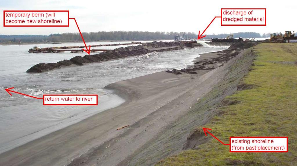
35 IMPLEMENTATION Targeted placement of 400,000 CY of sand dredged from the St. Helens Bar using the hydraulic dredge Oregon. pumping capacity 30,000-40,000 gallons/day = 20,000-60,000 cy sand/day
36


37 Low pressure discharge of dredged material-water mixture at shore interface: Traditional shoreline placement best for making low relief features (sand bars) with high enough elevation that shore equipment can grade
Response of a Newly Created Marsh-Wetland Affected by Tidal Forcing, Upland Discharge, and Groundwater Interaction
 Response of a Newly Created Marsh-Wetland Affected by Tidal Forcing, Upland Discharge, and Groundwater Interaction Mouth of Columbia River, Cape Disappointment State Park, Washington 12 Hans R. Moritz
X.B WETLANDS ROGUE RIVER ESTUARY
 X.B WETLANDS ROGUE RIVER ESTUARY The Rogue River has a drainage area of 5,100 square miles, yet the estuary of the Rogue River is one of the smallest in Oregon, measuring approximately 1,880 acres during
APPENDIX C. Fluvial and Tidal Hydraulics Report
 APPENDIX C Fluvial and Tidal Hydraulics Report BUENA VISTA LAGOON ENHANCEMENT PROJECT FLUVIAL AND TIDAL HYDRAULICS ANALYSES Prepared for: SANDAG 401 B Street, Suite 800 San Diego, California 92101 Contact:
RESILIENCE THROUGH RESTORATION
 RESILIENCE THROUGH RESTORATION RECLAMATION DISTRICT NO. 1601 TWITCHELL ISLAND SAN JOAQUIN RIVER SETBACK LEVEE PROJECT TWITCHELL ISLAND BASICS Nearly 12 miles of levee Storm drainage facilities Protects
APPENDIX D W-19 FLUVIAL AND TIDAL HYDRAULIC, SEDIMENTATION, WATER QUALITY AND SEA LEVEL RISE MODELING STUDIES
 APPENDIX D W-19 FLUVIAL AND TIDAL HYDRAULIC, SEDIMENTATION, WATER QUALITY AND SEA LEVEL RISE MODELING STUDIES Final EIR November 2018 Appendices Executive Summary Background: The San Dieguito Lagoon W19
Modeling Historic Columbia River Flood Impacts
 Modeling Historic Columbia River Flood Impacts Columbia River Estuary Workshop May 30, 2014 Present by: Lumas Helaire; Graduate Student, Portland State University Andrew Mahedy; Graduate Student, Portland
Louisiana CPRA SJB Group, Baton Rouge Coastal Engineering Consultants U.S. Army Corps of Engineers Federal and State PDT Members
 Louisiana CPRA SJB Group, Baton Rouge Coastal Engineering Consultants U.S. Army Corps of Engineers Federal and State PDT Members Project Setting and Background Island Restoration Plans Pre-Screening Analysis
CALCASIEU SALINITY STRUCTURES. HYDRODYNAMIC MODELING (To Support Design of Salinity Barriers)
") CALCASIEU SALINITY STRUCTURES HYDRODYNAMIC MODELING (To Support Design of Salinity Barriers) Presentation Overview 1 2 3 4 5 Project Overview and CEA Circulation Modeling Vessel Hydrodynamics Modeling
CALCASIEU SALINITY STRUCTURES HYDRODYNAMIC MODELING (To Support Design of Salinity Barriers) Presentation Overview 1 2 3 4 5 Project Overview and CEA Circulation Modeling Vessel Hydrodynamics Modeling
Puget Sound Nearshore Ecosystem Restoration Project Restore America s Estuaries Conference 2012 Tampa, FL
 Restore America s Estuaries Conference 2012 Tampa, FL presented by: Theresa Mitchell, WA Dept. of Fish & Wildlife Nearshore General Investigation Change Analysis: Comparison of historical and current
FACT SHEET MCGREGOR LAKE RESTORATION HABITAT PROJECT POOL 10, UPPER MISSISSIPPI RIVER, WISCONSIN ENVIRONMENTAL MANAGEMENT PROGRAM
 FACT SHEET MCGREGOR LAKE RESTORATION HABITAT PROJECT POOL 10, UPPER MISSISSIPPI RIVER, WISCONSIN ENVIRONMENTAL MANAGEMENT PROGRAM LOCATION McGregor Lake is located within a mid-river island in Pool 10
Emergent Sandbar Habitat Program Middle Missouri River
 Emergent Sandbar Habitat Program Middle Missouri River Jeremiah Szynskie, P.E. Hydrologic Engineering Branch Introduction Main Stem System Dam Closures Fort Peck 1937 Fort Randall 1952 Garrison - 1953
Southwest Washington Littoral Drift Restoration Project: Design, Construction, and Monitoring
 Southwest Washington Littoral Drift Restoration Project: Design, Construction, and Monitoring J Jessica i St Stokke kk USACE Portland District October 28, 2010 WEDA Pacific Meeting Monterey, CA US Army
Evaluation of Placement Alternatives for Matagorda Ship Channel Bottleneck Removal
 Evaluation of Placement Alternatives for Matagorda Ship Channel Bottleneck Removal James Rosati III Ashley E. Frey CPT Grays Harbor, WA Wood Wood chips Flour Other CMS Shark River Inlet, NJ US Army Corps
MOREHEAD CITY HARBOR, NC. Dredged Material Management Plan (DMMP)
") MOREHEAD CITY HARBOR, NC Dredged Material Management Plan (DMMP) Public Meeting/Info Session 15 January 2014 US Army Corps of Engineers Morehead City Harbor DMMP Presentation Topics Morehead City Harbor
MOREHEAD CITY HARBOR, NC Dredged Material Management Plan (DMMP) Public Meeting/Info Session 15 January 2014 US Army Corps of Engineers Morehead City Harbor DMMP Presentation Topics Morehead City Harbor
LIFE HISTORY DIVERSITY AND RESILIENCE
 LIFE HISTORY DIVERSITY AND RESILIENCE SPRING CHINOOK IN THE WILLAMETTE RIVER BASIN Kirk Schroeder Brian Cannon Luke Whitman Paul Olmsted Oregon Department of Fish and Wildlife Corvallis Research Lab Thanks
Eulachon: State of the Science and Science to Policy Forum
 Eulachon: State of the Science and Science to Policy Forum August 27, 2015 Robert Anderson Eulachon Recovery Coordinator National Marine Fisheries Service FCRPS, Dams, and Water Management in the Columbia
Assateague Island National Seashore North End Restoration Project Timeline
 Assateague Island National Seashore North End Restoration Project Timeline Date Event Some information provided in the Project Introduction document. Detailed events are available in a timeline compiled
Tanya M. Beck. Kelly Legault. Research Physical Scientist Coastal & Hydraulics Lab, ERDC Vicksburg, MS
 Inlet And Adjacent Shoreline Processes at Cascading Time Scales Using the Coastal Modeling System and GenCade Tanya M. Beck Research Physical Scientist Coastal & Hydraulics Lab, ERDC Vicksburg, MS Kelly
Oregon Estuaries defined: (Goal 16)
") Bob Bailey, Manager, Oregon Coastal Management Program Oregon Estuaries defined: (Goal 16) includes estuarine water, tidelands, tidal marshes, and submerged lands. Estuaries extend upstream to the head
Bob Bailey, Manager, Oregon Coastal Management Program Oregon Estuaries defined: (Goal 16) includes estuarine water, tidelands, tidal marshes, and submerged lands. Estuaries extend upstream to the head
CHAPTER 4 DESIRED OUTCOMES: VISION, GOALS, AND OBJECTIVES
 CHAPTER 4 DESIRED OUTCOMES: VISION, GOALS, AND OBJECTIVES Vision One of the first steps in developing this Plan was articulating a vision - a clear statement of what the Plan strives to achieve and what
Fish Habitat Restoration and Monitoring in Southeast Washington. Andy Hill Eco Logical Research, Inc.
 Fish Habitat Restoration and Monitoring in Southeast Washington Andy Hill Eco Logical Research, Inc. Fish Habitat Restoration and Monitoring in Southeast Washington Talk overview: Restoration projects
Big Spring Creek Habitat Enhancement and Fishery Management Plans
 Big Spring Creek Habitat Enhancement and Fishery Management Plans November 5, 2012 Big Spring Events and Activities Center Newville, PA Charlie McGarrell Regional Habitat Biologist Pennsylvania Fish and
Simulating Streams Through Culverts in Mat-Su, Alaska
 Simulating Streams Through Culverts in Mat-Su, Alaska Project Managers Bill Rice, P.E., USFWS Hydrologist Mary Price, USFWS Fishery Biologist The Team Approach US Fish and Wildlife Service Bill Rice, P.E.,
OKANAGAN RIVER RESTORATION INITIATIVE - FAQ
 OKANAGAN RIVER RESTORATION INITIATIVE - FAQ Initiative background: The health of the q awsitk w (Okanagan River) has been severely impacted by the channelization works that occurred in the mid-1950 s.
Follets Island Nearshore Beach Nourishment Project
 Coast & Harbor Engineering A division of Hatch Mott MacDonald Follets Island Nearshore Beach Nourishment Project Arpit Agarwal, P.E. April 1, 2016 Project Site!"#$% &'(% &)*+% )#,'-+% Shoreline Erosion
Water Resources Report RKLD Annual Meeting July 30, 2016
 Water Resources Report RKLD Annual Meeting 2016 July 30, 2016 Topics Hydrology Report Indianford Dam trash rack cleanout performance Experimental Project update Review of PAS project Twin floods- 1 to
The Blue Heron Slough Conservation Bank
 1 The Blue Heron Slough Conservation Bank CONSERVATION BANKING July 19-23, 2010 CASE STUDY SERIES The Blue Heron Slough Conservation Bank (Washington) I. OVERVIEW & BACKGROUND: Location: Snohomish River
FISHERIES BLUE MOUNTAINS ADAPTATION PARTNERSHIP
 FISHERIES A warming climate, by itself, substantially affects the hydrology of watersheds in the Blue Mountains. Among the key hydrologic changes projected under all scenarios for the 2040s and beyond
100-YEARS OF SHOAL EVOLUTION AT THE MOUTH OF THE COLUMBIA RIVER: IMPACTS ON CHANNEL, STRUCTURES, AND SHORELINES
 100-YEARS OF SHOAL EVOLUTION AT THE MOUTH OF THE COLUMBIA RIVER: IMPACTS ON CHANNEL, STRUCTURES, AND SHORELINES Hans R. Moritz, 1 Heidi P. Moritz, 2 Jessica R. Hays, 3 and Heather R. Sumerell 4 Abstract:
Restoring the Kootenai: A Tribal Approach to Restoration of a Large River in Idaho
 Restoring the Kootenai: A Tribal Approach to Restoration of a Large River in Idaho Susan Ireland, Kootenai Tribe of Idaho Future of our Salmon Conference Technical Session August 2016 Healthy Floodplains,
Request Number IR1-12: Flow Passage. Information Request
 Request Number IR1-12: Flow Passage Information Request Provide additional information about the 100 metre flow passage channel scenario between the Westshore Terminals and the proposed Project terminal
Sediment Management Plan Rehoboth Bay
 Sediment Management Plan Rehoboth Bay STAC Meeting November 16, 2007 Goals of the Study Improve planning for future dredging needs Reduce the dependency on dredging Study Tasks Environmental data Historical
PLAQUEMINES PARISH BARRIER ISLAND RESTORATION & SUSTAINABILITY. MVD/Gulf Coast Regional Dredging Meeting November 5, 2013
 PLAQUEMINES PARISH BARRIER ISLAND RESTORATION & SUSTAINABILITY MVD/Gulf Coast Regional Dredging Meeting November 5, 2013 OVERVIEW 1. Barrier Island Restoration Projects in Plaquemines Parish 2. Plaquemines
Environmental. Effects of Dredging
 Envi~onmental Effects of Dredging Technical Notes THE VALUE OF GRAVEL DISPOSAL MOUNDS IN RIVER SIDE CHANNELS FOR FRESHWATER MUSSELS PURPOSE: This note provides information on the value of gravel disposal
Ecology of Place: What salmon need Eric Beamer Skagit River System Cooperative. November 2010
 Ecology of Place: What salmon need Eric Beamer Skagit River System Cooperative November 2010 Acknowledgements NOAA Fisheries NW Fisheries Science Center Tim Beechie George Pess Correigh Greene Talk overview
Conservation and Restoration Florida s Coastal Marshes: An Overview of MESS. Jeff Beal, Kent Smith, Erin McDevitt, Maria Merrill
 Conservation and Restoration Florida s Coastal Marshes: An Overview of MESS Jeff Beal, Kent Smith, Erin McDevitt, Maria Merrill FWC s MESS: -Marine/Estuarine Subsection -within Aquatic Habitat Conservation
Modeling changes to the historic Lower Columbia River Estuary using Delft3D. Drew Mahedy Lumas Helaire Stefan Talke David Jay May 30, 2014
 Modeling changes to the historic Lower Columbia River Estuary using Delft3D Drew Mahedy Lumas Helaire Stefan Talke David Jay May 30, 2014 Comparison: Historic and Modern LCRE US Coastal Survey, 1868 Historic
11426 Moorage Way P.O. Box 368 LaConner, WA Phone: Fax:
 Skagit River System Cooperative 11426 Moorage Way P.O. Box 368 LaConner, WA 98257-368 Phone: 36-466-7228 Fax: 36-466-447 www.skagitcoop.org BULL TROUT USE OF SWINOMISH RESERVATION WATERS Eric Beamer, Rich
Puget Sound Shorelines. Waves and coastal processes. Puget Sound shorelines: Effects of beach armoring
 Puget Sound Shorelines Puget Sound shorelines: Effects of beach armoring Waves and coastal processes Factors affecting wave energy hitting the coast Processes transporting sediment along coastlines What
OFFICE OF STRUCTURES MANUAL FOR HYDROLOGIC AND HYDRAULIC DESIGN CHAPTER 11 APPENDIX B TIDEROUT 2 USERS MANUAL
 OFFICE OF STRUCTURES MANUAL FOR HYDROLOGIC AND HYDRAULIC DESIGN CHAPTER 11 APPENDIX B TIDEROUT 2 USERS MANUAL APRIL 2011 APRIL 2011 Page 1 Preface TIDEROUT 2, Build 1.22 dated June 29, 2006 is the current
Ocean and Plume Science Management Uncertainties, Questions and Potential Actions (Work Group draft 11/27/13)
") Ocean and Plume Science Management Uncertainties, Questions and Potential Actions (Work Group draft 11/27/13) (The work group thinks the following four questions should form a logic path, but that logic
Ocean and Plume Science Management Uncertainties, Questions and Potential Actions (Work Group draft 11/27/13) (The work group thinks the following four questions should form a logic path, but that logic
2015 Adult Returns and 2016 Expectations Columbia River Preliminary Draft December 14, 2015
 2015 Adult Returns and 2016 Expectations Columbia River Preliminary Draft December 14, 2015 Adult Returns 2015 Results 2016 Expectations Willamette Spring (includes jacks) 55,400 predicted return to CR
APPENDIX M DREDGED MATERIAL MANAGEMENT PLAN (DMMP) FINAL INTEGRATED FEASIBILITY REPORT AND ENVIRONMENTAL ASSESSMENT
 FINAL INTEGRATED FEASIBILITY REPORT AND ENVIRONMENTAL ASSESSMENT") APPENDIX M DREDGED MATERIAL MANAGEMENT PLAN (DMMP) Brazos Island Harbor, Texas Channel Improvement Study FINAL INTEGRATED FEASIBILITY REPORT AND ENVIRONMENTAL ASSESSMENT This page is intentionally left
APPENDIX M DREDGED MATERIAL MANAGEMENT PLAN (DMMP) Brazos Island Harbor, Texas Channel Improvement Study FINAL INTEGRATED FEASIBILITY REPORT AND ENVIRONMENTAL ASSESSMENT This page is intentionally left
SUMMARY OF MOVEMENT AND HABITAT USED BY TAGGED BROOK TROUT IN THE MAIN BRANCH AND NORTH BRANCH AU SABLE RIVER DURING SUMMER Data Submitted to:
 SUMMARY OF MOVEMENT AND HABITAT USED BY TAGGED BROOK TROUT IN THE MAIN BRANCH AND NORTH BRANCH AU SABLE RIVER DURING SUMMER 2014 Data Submitted to: Anglers of the Au Sable Submitted by: Dr. Mark R. Luttenton
Impact of Dredging the Lower Narrow River on Circulation and Flushing
 Impact of Dredging the Lower Narrow River on Circulation and Flushing Craig Swanson Ph.D. Swanson Environmental Alex Shaw Ocean Engineering, URI Prof. Malcolm L. Spaulding Ocean Engineering, URI 29 January
Study Update Tailrace Slough Use by Anadromous Salmonids
 Study Update Tailrace Slough Use by Anadromous Salmonids Goals and Objectives Identify what anadromous salmonids use the tailrace slough by: Life Stage (Juvenile, migrating and spawning adults) Timing
Juvenile chum migration patterns in the lower Columbia River and estuary
 Juvenile chum migration patterns in the lower Columbia River and estuary Curtis Roegner Dan Bottom Kristen Homel Thanks to the many NOAA and CE colleagues! * Columbia River Estuary Workshop 214 * Collapse
PNWA Conference Update
 PNWA Conference Update COLONEL Jose Aguilar District Commander Portland District 2 October, 2014 US Army Corps of Engineers Projects Mouth of the Columbia (MCR) Jetties Columbia River Status Coastal Dredging
Mouth of the Columbia River Jetties Three-Phase Construction Plan
 Mouth of the Columbia River Jetties Three-Phase Construction Plan Project Overview October 9, 2012 US Army Corps of Engineers MCR Jetties Major Rehabilitation Sand Island pile dikes 1930-1935 Columbia
CHAPTER 134 INTRODUCTION
 CHAPTER 134 NEW JETTIES FOR TUNG-KANG FISHING HARBOR, TAIWAN Chi-Fu Su Manager Engineering Department Taiwan Fisheries Consultants, Inc. Taipei, Taiwan INTRODUCTION Tung-Kang Fishing Harbor, which is about
Nearshore Dredged Material Placement Pilot Study at Noyo Harbor, CA
 1 Nearshore Dredged Material Placement Pilot Study at Noyo Harbor, CA Noyo Cove N 2011 National Conference on Beach Preservation Technology 9-11, February 2011 Lihwa Lin, Honghai Li, Mitchell Brown US
JAP Additional Information Sheet
 JAP Additional Information Sheet Block 15: Purpose and Need The USACE purpose of the project is to provide a safe and reliable whitewater park for the recreational public in a city park, which will provide
Hydraulic Modeling Analysis
 Final Report Photograph: http://www.newington-dover.com Newington to Dover, New Hampshire Prepared for: Vanasse Hangen Brustlin, Inc. 6 Bedford Farms Drive, Suite 607 Bedford, New Hampshire 03110-6532
Impacts of breakwaters and training walls
 Across the eastern seaboard of Australia, breakwaters and training walls have instigated fundamental perturbations to coastal and estuary processes. This has induced long-term changes to foreshore alignments,
Design and Construction of Living
 Design and Construction of Living Shorelines A course for living shorelines professionals September 29, 2010 This course made possible by a grant from the Virginia Coastal Zone Management Program NOAA
2017 Adult Returns and 2018 Expectations Columbia River Updated Draft January 11, 2018
 Willamette Spring 2017 Adult Returns and 2018 Expectations Columbia River Updated Draft January 11, 2018 2017 Results 2018 Expectations 38,100 predicted adult return to CR (19% wild) 50,774 actual adult
FACT SHEET I. LOCATION
 STEAMBOAT ISLAND HABITAT REHABILITATION AND ENHANCEMENT PROJECT (HREP) SCOTT COUNTY, IOWA, UPPER MISSISSIPPI RIVER RESTORATION-ENVIRONMENTAL MANAGEMENT PROGRAM ROCK ISLAND DISTRICT FACT SHEET I. LOCATION
Shoalwater Bay Shorline Erosion Dredging
 Shoalwater Bay Shorline Erosion Dredging ROSS ISLAND SAND & GRAVEL CO. Saving the Tokeland Penninsula Willapa Bay & Tokeland Penninsula Southwestern Washington Coast Shoalwater Bay Historic View Settlements
MEMORANDUM. July 2, Council members. Tony Grover, Fish and Wildlife Division Director SUBJECT:
 Bill Bradbury Chair Oregon Henry Lorenzen Oregon W. Bill Booth Idaho James A. Yost Idaho Jennifer Anders Vice Chair Montana Pat Smith Montana Tom Karier Washington Phil Rockefeller Washington July 2, 2013
ABSTRACT. KEY WORDS: Navigation safety; numerical modeling; waves; current; sediment transport; channel infilling; morphology change.
 The 25th (2015) International Polar and Engineering Conference Li, H., L. Lin, Z. Demirbilek, T. M. Beck, and H. R. Moritz (2015). Wave-Current Conditions and Navigation Safety at an Inlet Entrance. The
DELAWARE S VULNERABLE COASTAL AREAS. DELAWARE INLAND BAYS and DELAWARE BAY RECONNAISSANCE STUDY
 DELAWARE S VULNERABLE COASTAL AREAS and the DELAWARE INLAND BAYS and DELAWARE BAY RECONNAISSANCE STUDY Kimberly K. McKenna, PG Delaware Dept. of Natural Resources & Environmental Control Division of Watershed
Kootenai River Habitat Restoration Program. Kootenai Tribe of Idaho - January 27, 2014 Presentation for Kootenai Valley Resource Initiative
 Kootenai River Habitat Restoration Program Kootenai Tribe of Idaho - January 27, 2014 Presentation for Kootenai Valley Resource Initiative Decline of native species Kootenai River White Sturgeon ENDANGERED
SHORE PROTECTION AND HABITAT CREATION AT SHAMROCK ISLAND, TEXAS ABSTRACT
 SHORE PROTECTION AND HABITAT CREATION AT SHAMROCK ISLAND, TEXAS M. Cameron Perry, P.E., and Daniel J. Heilman, P.E. Coastal Engineer Shiner Moseley & Associates., Inc. 555 N. Carancahua Corpus Christi,
Estuarine Shoreline Stabilization
 Estuarine Shoreline Stabilization Property Owner s Guide to Determining the Most Appropriate Stabilization Method Estuarine shorelines are dynamic features that experience continued erosion. Land is lost
Culvert Design for Low and High Gradient Streams in the Midwest. Dale Higgins, Hydrologist Chequamegon-Nicolet National Forest
 Culvert Design for Low and High Gradient Streams in the Midwest Dale Higgins, Hydrologist Chequamegon-Nicolet National Forest Overview Culvert Design Considerations Hydraulic Terms Culvert Impacts Low
Monitoring of Downstream Fish Passage at Cougar Dam in the South Fork McKenzie River, Oregon February 8, By Greg A.
 Monitoring of Downstream Fish Passage at Cougar Dam in the South Fork McKenzie River, Oregon 1998- February 8, 2 By Greg A. Taylor Oregon Dept. of Fish & Wildlife 315 E. Main Street Springfield, OR 97478
RE: Hurricane Matthew Beach Damage Assessment and Recommendations [CSE 2416]
![RE: Hurricane Matthew Beach Damage Assessment and Recommendations [CSE 2416]](/thumbs/83/87675702.jpg "RE: Hurricane Matthew Beach Damage Assessment and Recommendations [CSE 2416]") October 25, 2016 Iris Hill Town Administrator Town of Edisto Beach 2414 Murray St Edisto Beach SC 29438 RE: Hurricane Matthew Beach Damage Assessment and Recommendations [CSE 2416] Dear Iris, Hurricane
October 25, 2016 Iris Hill Town Administrator Town of Edisto Beach 2414 Murray St Edisto Beach SC 29438 RE: Hurricane Matthew Beach Damage Assessment and Recommendations [CSE 2416] Dear Iris, Hurricane
Effect of Hydrodynamics on Sediment Transport near a Coastal Inlet
 ICHE 2014, Hamburg - Lehfeldt & Kopmann (eds) - 2014 Bundesanstalt für Wasserbau ISBN 978-3-939230-32-8 Effect of Hydrodynamics on Sediment Transport near a Coastal Inlet H. Li, M. Brown, J. Rosati & Z.
Nome Harbor Page 2 of 12
 Nome Harbor Nome Harbor Page 2 of 12 Condition of Improvements 30 December 2015 Nome Harbor, Alaska (CWIS No. 010422, 012270, 072742, 087755) Authorization (1) Rivers and Harbors Act, 8 August 1917 (House
Mid-Columbia Fisheries Enhancement Group Annual Report Fiscal Year 06: July 1, 2005 June 30, 2006
 Mid-Columbia Fisheries Enhancement Group Annual Report Fiscal Year 06: July 1, 2005 June 30, 2006 Mission Statement The mission of the Mid-Columbia Fisheries Enhancement Group is to restore self-sustaining
Trout Unlimited Comments on the Scope of Environmental Impact Statement for the Constitution Pipeline Project, Docket No. PF12-9
 October 9, 2012 Kimberly D. Bose, Secretary Federal Energy Regulatory Commission 888 First Street, NE, Room 1A Washington, DC 20426 RE: Trout Unlimited Comments on the Scope of Environmental Impact Statement
Rehabilitation of Grimes Creek, a Stream Impacted in the Past by Bucket-lined Dredge Gold Mining, Boise River Drainage, July 2008 to August 2011.
 Rehabilitation of Grimes Creek, a Stream Impacted in the Past by Bucket-lined Dredge Gold Mining, Boise River Drainage, July 2008 to August 2011. Pam Harrington TU,1020 W. Main Street Suite 440, Boise,
Coastal Sediment Transport Modeling Ocean Beach & San Francisco Bight, CA
 1 Coastal Sediment Transport Modeling Ocean Beach & San Francisco Bight, CA Honghai Li and Lihwa Lin Engineering Research and Development Center U.S. Army Corps of Engineers Frank Wu, Lisa Andes, and James
APPENDIX L DETAILED ANALYSIS OF EAST AND LATERAL RUNWAY SAFETY AREA ALTERNATIVES ON TIDAL CHANNEL GEOMORPHOLOGY
 APPENDIX L DETAILED ANALYSIS OF EAST AND LATERAL RUNWAY SAFETY AREA ALTERNATIVES ON TIDAL CHANNEL GEOMORPHOLOGY MEMORANDUM TO: Sheri Ellis (SWCA), Patti Sullivan (FAA), Allan Heese (JNU), Randy Vigil (ACOE),
Hydrodynamic Modeling of Tides and Hurricane Storm Surge for Pre- and Post-Dredging Conditions in the Lower St. Johns River, Florida
 Hydrodynamic Modeling of Tides and Hurricane Storm Surge for Pre- and Post-Dredging Conditions in the Lower St. Johns River, Florida Matthew V. Bilskie 1 1 PhD Student, University of Central Florida, Department
OREGON AND WASHINGTON DEPARTMENTS OF FISH AND WILDLIFE JOINT STAFF REPORT - WINTER FACT SHEET NO.
 OREGON AND WASHINGTON DEPARTMENTS OF FISH AND WILDLIFE JOINT STAFF REPORT - WINTER FACT SHEET NO. 3a Columbia River Compact/Joint State Hearing February 21, 2018 Fisheries under consideration: Mainstem
North Shore of Long Island, Feasibility Study
 North Shore of Long Island, Asharoken New York Asharoken, Feasibility Study Asharoken, NY Public Meeting June 30, 2015 US Army Corps of Engineers US Army Corps of Engineers New York BUILDING STRONG BUILDING
Climate Change Adaptation and Stream Restoration. Jack Williams;
 Climate Change Adaptation and Stream Restoration Jack Williams; jwilliams@tu.org 1 Goals for this presentation Develop strategies for adapting streams to climate impacts by Thinking like a watershed Understanding
For next Thurs: Jackson et al Historical overfishing and the recent collapse of coastal ecosystems. Science 293:
 For next Thurs: Jackson et al. 2001. Historical overfishing and the recent collapse of coastal ecosystems. Science 293: 629-637. Resource: means of supplying a want or deficiency, from French resourdre
Sussex County, DE Preliminary Study Overview
 Sussex County, DE Preliminary Study Overview Coastal study scope: 102 miles of entire County shoreline Revised 102 panels for coastal study Riverine study scope: 14 streams, 67.1 miles, within the Nanticoke
VIMS CCRM Coastal Management Decision Tools. Decision Tree for Undefended Shorelines and Those with Failed Structures
 VIMS CCRM Coastal Management Decision Tools Decision Tree for Undefended Shorelines and Those with Failed Structures Center for Coastal Resources Management Virginia Institute of Marine Science Gloucester
Warm-up # 7 A day 5/17 - B day 5/18 UPDATE YOUR TABLE OF CONTENTS
 Warm-up # 7 A day 5/17 - B day 5/18 UPDATE YOUR TABLE OF CONTENTS Question: List all examples of surface water on Earth. Answer: Rivers and streams, lakes and reservoirs, (ponds) wetlands, estuaries and
Washington State Fish Passage Barrier Removal Projects. Casey Kramer, PE WSDOT State Hydraulics Engineer
 Washington State Fish Passage Barrier Removal Projects Casey Kramer, PE WSDOT State Hydraulics Engineer 2014 National Hydraulic Engineering Conference Iowa City, IA August 20 th, 2014 WSDOT Fish Passage
What happens to Oregon s tidal wetlands with sea level rise?
 What happens to Oregon s tidal wetlands with sea level rise? Laura Brophy Estuary Technical Group Institute for Applied Ecology Corvallis, OR Laura@appliedeco.org Project maps future tidal wetlands, predicts
Incorporating Geomorphic Processes and Sediment Dynamics into Salmonid Habitat Restoration Design
 Salmonid Restoration Federation 35 th Annual Salmonid Restoration Conference Davis, CA Incorporating Geomorphic Processes and Sediment Dynamics into Salmonid Habitat Restoration Design Concurrent Session:
1-32 NOME HARBOR, ALASKA (CWIS NOS , 87755, & 10422) Condition of Improvement 30 September 2009
 Condition of Improvement 30 September 2009") NOME HARBOR 1-32 NOME HARBOR, ALASKA (CWIS NOS. 72742, 87755, & 10422) Condition of Improvement 30 September 2009 AUTHORIZATION: (1) Rivers and Harbors Act, 8 August 1917 (House Doc. 1932, 64th Congress,
NOME HARBOR 1-32 NOME HARBOR, ALASKA (CWIS NOS. 72742, 87755, & 10422) Condition of Improvement 30 September 2009 AUTHORIZATION: (1) Rivers and Harbors Act, 8 August 1917 (House Doc. 1932, 64th Congress,
Albeni Falls Dam Downstream Water Temperature Study Interim Results
 Albeni Falls Dam Downstream Water Temperature Study Interim Results Amy Reese, Chief Water Management Section Seattle District June 24, 2014 US Army Corps of Engineers What we hope to cover today Albeni
2018 Adult Returns and 2019 Expectations Columbia River Revised Draft December 12, 2018
 Willamette Spring 2018 Adult Returns and 2019 Expectations Columbia River Revised Draft December 12, 2018 2018 Results 2019 Expectations 53,820 predicted adult return to CR (20% wild) 37,441 actual adult
Tidal Energy from the Severn Estuary: Opportunities and Challenges
 Co-financed with the support of the European Union 1 ERDF Atlantic Area Programme Investing in our common future Tidal Energy from the Severn Estuary: Opportunities and Challenges Prof Roger Falconer,
Louisiana s 2012 Coastal Master Plan BARRIER SHORELINE MORPHOLOGY MODEL
 Louisiana Coastal Protection & Restorat coastal.louisiana.gov Louisiana s 2012 Coastal Master Plan PREDICTIVE MODELING: committed to our coast BARRIER SHORELINE MORPHOLOGY MODEL Dallon Weathers, University
ALTERNATIVES FOR COASTAL STORM DAMAGE MITIGATION AND FUNCTIONAL DESIGN OF COASTAL STRUCTURES
 The University of the West Indies Organization of American States PROFESSIONAL DEVELOPMENT PROGRAMME: COASTAL INFRASTRUCTURE DESIGN, CONSTRUCTION AND MAINTENANCE A COURSE IN COASTAL DEFENSE SYSTEMS I CHAPTER
PROJECT OVERVIEW PROJECT AREA. FAHCE Fish Habitat Restoration Plan EIR
 PROJECT OVERVIEW PROJECT AREA FISH AND AQUATIC HABITAT COLLABORATIVE EFFORT (FAHCE) Fish Habitat Restoration Plan Project Area PROJECT OVERVIEW DOCUMENTS A Settlement Agreement Regarding Water Rights of
Planning Considerations for Nearshore Placement of Mixed Dredged Sediments
 Planning Considerations for Nearshore Placement of Mixed Dredged Sediments PURPOSE: Dredging planning and management decisions are based on a combination of engineering and economic factors tempered by
Staying in Tune with South Florida s Water Cycle for Scientists, Managers, and Policy Makers in 5 Minutes per Week
 Staying in Tune with South Florida s Water Cycle for Scientists, Managers, and Policy Makers in 5 Minutes per Week Robert Sobczak (Big Cypress Nat l Pres), Todd Hopkins (FWS), Kevin Kotun (Everglades National
New Orleans Municipal Yacht Harbor
 New Orleans Municipal Yacht Harbor Marina Schematic Design Update 601 Poydras St., Suite 1860 New Orleans, LA, 70130 504-648-3560 Post-Katrina Municipal Yacht Harbor: Introduction The MYH was an approximate
ALTERNATIVES FOR COASTAL STORM DAMAGE MITIGATION
 ALTERNATIVES FOR COASTAL STORM DAMAGE MITIGATION Dave Basco Old Dominion University, Norfolk, Virginia, USA National Park Service Photo STRUCTURAL (changes to natural, physical system) hardening (seawalls,
Ninilchik Harbor Page 2 of 11
 Ninilchik Harbor Ninilchik Harbor Page 2 of 11 Condition of Improvements 31 December 2017 Ninilchik Harbor, Alaska (CWIS No. 012640, 087345) Authorization Rivers and Harbors Act, 3 July 1958 (P.L. 85-500
ST. LOUIS SECTION PROJECT OF THE YEAR AWARD
 ST. LOUIS SECTION PROJECT OF THE YEAR AWARD Originality and Innovation The St. Louis Harbor Project is located in the Upper Mississippi River between the entrance to the Chain of Rocks Canal at River
Minnesota Department of Natural Resources Division of Fish and Wildlife Section of Fisheries. Stream Survey Report. Luxemburg Creek.
 Minnesota F-29-R(P)-24 Area 315 Study 3 March 2016 Minnesota Department of Natural Resources Division of Fish and Wildlife Section of Fisheries Stream Survey Report Luxemburg Creek 2015 Mark Pelham Sauk
EVALUATING THE EFFECTS OF BIVALVE SHELLFISH AQUACULTURE AND ITS ECOLOGICAL ROLE IN THE ESTUARINE ENVIRONMENT IN THE UNITED STATES
 EVALUATING THE EFFECTS OF BIVALVE SHELLFISH AQUACULTURE AND ITS ECOLOGICAL ROLE IN THE ESTUARINE ENVIRONMENT IN THE UNITED STATES Brett Dumbauld USDA Agricultural Research Service, Hatfield Marine Science