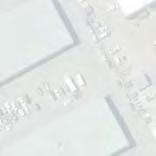
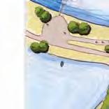
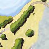
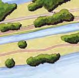
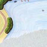
J.A. and Kathryn Albertson Family Foundation Boise Whitewater Park Phase II Final Environmental Review Figure 5. Temporary Construction Measures McMil
|
|
|
- Maximillian Neal
- 5 years ago
- Views:
Transcription
1
2
3
4
5

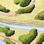
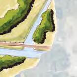
6 J.A. and Kathryn Albertson Family Foundation Boise Whitewater Park Phase II Final Environmental Review Figure 5. emporary Construction Measures McMillen Jacobs Associates 10 November 22, 2017


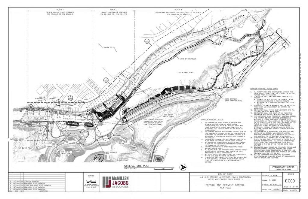
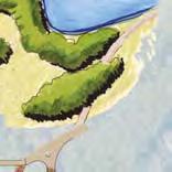
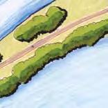
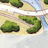
7 LOCAION MAP NS IN-WAER WORK PROJEC LIMIS PROJEC LOCAION ESHER SIMPLO PARK AERIAL PHOO NS VICINIY MAP LA/LONG / (WGS84) SECION 5, OWNSHIP 3N, RANGE 2E AND SECION 32, OWNSHIP 4N, RANGE 2E NS PRELIMINARY NO FOR CONSRUCION McMILLEN JACOBS ASSOCIAES J.A. AND KAHRYN ALBERSON FAMILY FOUNDAION BOISE WHIEWAER PARK PHASE II - JAP WELAND AND WAER IMPACS LOCAION MAP, VICINIY MAP AND AERIAL PHOO ADA COUNY, IDAHO RW GA 11/13/17 1


8 W G G PRELIMINARY NO FOR CONSRUCION McMILLEN JACOBS ASSOCIAES J.A. AND KAHRYN ALBERSON FAMILY FOUNDAION BOISE WHIEWAER PARK PHASE II - JAP WELAND AND WAER IMPACS OVERALL SIE KEY PLAN RW GA 11/13/17 2


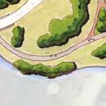
9 SEE SHEE 4 PRELIMINARY NO FOR CONSRUCION McMILLEN JACOBS ASSOCIAES J.A. AND KAHRYN ALBERSON FAMILY FOUNDAION BOISE WHIEWAER PARK PHASE II - JAP WELAND AND WAER IMPACS SIE PLAN 1 RW GA 11/13/17 3


10 SEE SHEE 5 SEE SHEE 3 PRELIMINARY NO FOR CONSRUCION McMILLEN JACOBS ASSOCIAES J.A. AND KAHRYN ALBERSON FAMILY FOUNDAION BOISE WHIEWAER PARK PHASE II - JAP WELAND AND WAER IMPACS SIE PLAN 2 RW GA 11/13/17 4
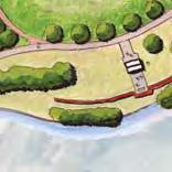
11 SEE SHEE 4 PRELIMINARY NO FOR CONSRUCION McMILLEN JACOBS ASSOCIAES J.A. AND KAHRYN ALBERSON FAMILY FOUNDAION BOISE WHIEWAER PARK PHASE II - JAP WELAND AND WAER IMPACS SIE PLAN 3 RW GA 11/13/17 5


12 SEE SHEE 7 SEE SHEE 8 PRELIMINARY NO FOR CONSRUCION McMILLEN JACOBS ASSOCIAES J.A. AND KAHRYN ALBERSON FAMILY FOUNDAION BOISE WHIEWAER PARK PHASE II - JAP WELAND AND WAER IMPACS SIE PLAN 5 RW GA 11/13/17 6
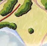
13 SEE SHEE 7 PRELIMINARY NO FOR CONSRUCION McMILLEN JACOBS ASSOCIAES J.A. AND KAHRYN ALBERSON FAMILY FOUNDAION BOISE WHIEWAER PARK PHASE II - JAP WELAND AND WAER IMPACS SIE PLAN 6 RW GA 11/13/17 7

14 SEE SHEE 6 PRELIMINARY NO FOR CONSRUCION McMILLEN JACOBS ASSOCIAES J.A. AND KAHRYN ALBERSON FAMILY FOUNDAION BOISE WHIEWAER PARK PHASE II - JAP WELAND AND WAER IMPACS SIE PLAN 7 RW GA 11/13/17 8

15 PRELIMINARY NO FOR CONSRUCION McMILLEN JACOBS ASSOCIAES J.A. AND KAHRYN ALBERSON FAMILY FOUNDAION BOISE WHIEWAER PARK PHASE II - JAP WELAND AND WAER IMPACS SUMMARY OF IMPACS RW GA 11/13/17 9


16 Reach 1 Excavate Side Channel Select Stands of rees to Remain for Islands Photograph 1 Looking South along area proposed for new side channel and islands. Excavate Side Channel Select Stands of rees to Remain for Islands Photograph 2 Looking South along area proposed for new side channel and islands. J.A. and Kathryn Albertson Family Foundation Boise Whitewater Park Phase II Joint Application for Permits

17 Remove Concrete Abutment and Regrade Bank Photograph 3 Looking at concrete abutment to be removed and bank regraded. J.A. and Kathryn Albertson Family Foundation Boise Whitewater Park Phase II Joint Application for Permits


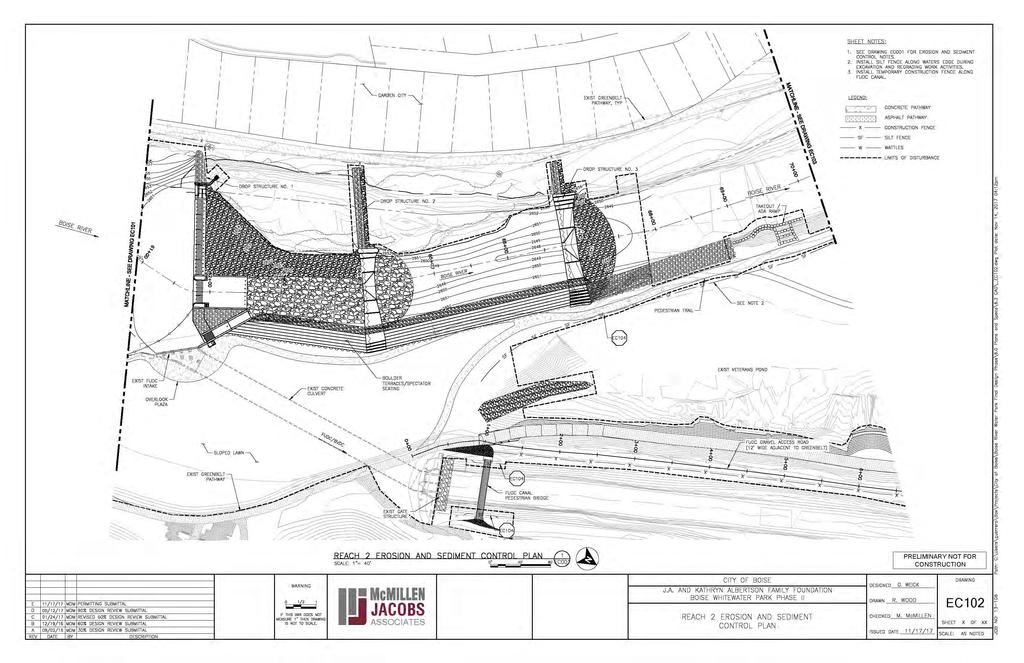
18 Reach 2 FUDC Diversion to be Replaced with Drop Structure 1 Photograph 4 Looking east at FUDC Diversion to be replaced with drop structure 1. Construct Boulder errace Construct Drop Structure 2 Photograph 5 Looking north at location for drop structure 2 and the eroded right river bank to be stabilized with a boulder terrace. J.A. and Kathryn Albertson Family Foundation Boise Whitewater Park Phase II Joint Application for Permits


19 Construct Boulder errace Photograph 6 Looking northeast at eroded right bank to be replaced with a boulder terrace. Construct Drop Structure 3 Photograph 7 Looking west at location for drop structure 3. J.A. and Kathryn Albertson Family Foundation Boise Whitewater Park Phase II Joint Application for Permits


20 Photograph 8 Looking at existing side channel along left bank. Construct Access Ramp 1 Photograph 9 Looking along right bank at location for access ramp 1 into the Boise River. J.A. and Kathryn Albertson Family Foundation Boise Whitewater Park Phase II Joint Application for Permits


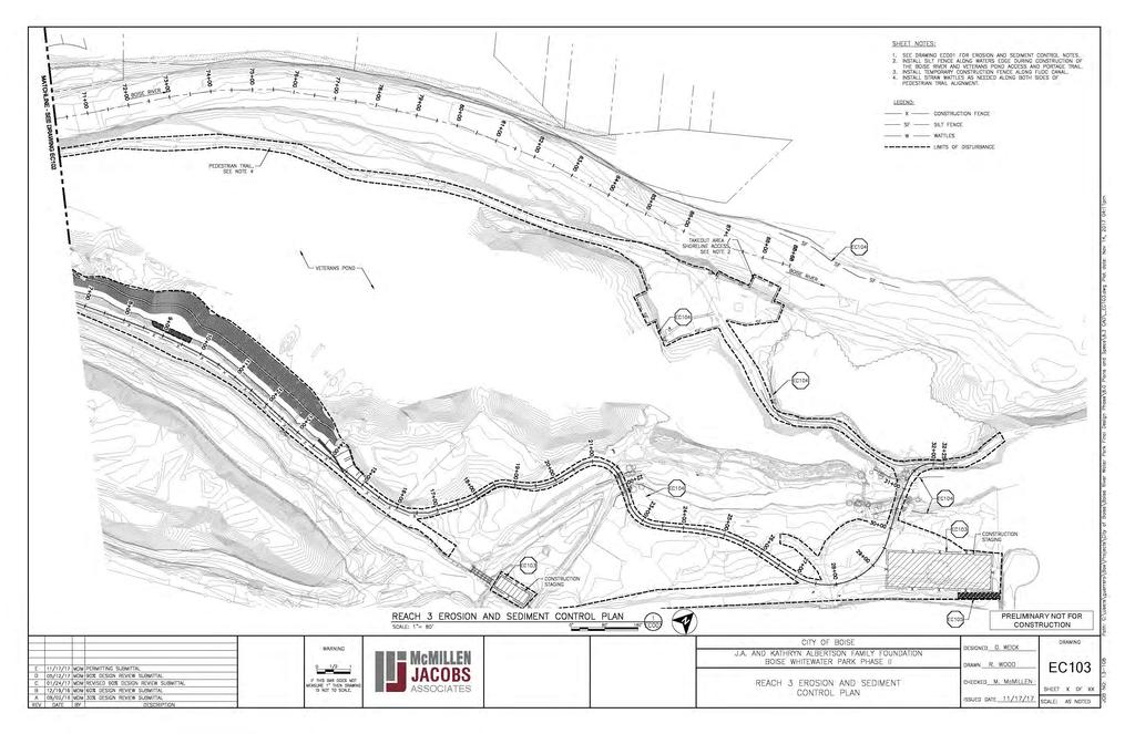
21 Reach 3 Construct Access Ramp 2 Photograph 10 Looking along right bank at location for access ramp 2 into the Boise River. Construct Access Ramp 3 Photograph 11 Looking northeast at location for access ramp 3 into Veteran s Pond. J.A. and Kathryn Albertson Family Foundation Boise Whitewater Park Phase II Joint Application for Permits


22 Photograph 12 Looking at Bridge 1 to be replaced. Photograph 13 Looking at Bridge 2 to be realigned. J.A. and Kathryn Albertson Family Foundation Boise Whitewater Park Phase II Joint Application for Permits


")


")


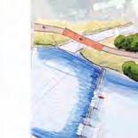
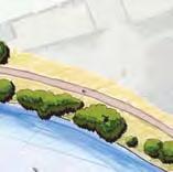


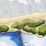
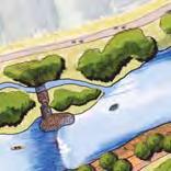
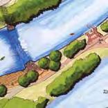
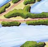


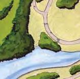

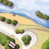
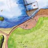

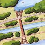


23 1309 E 3RD A VE, ROOM 2 3 DURANGO, CO REACH 1 ESHER SIMPLO PARK INERFACE REACH 2 PRIMARY WHIEWAER FEAURES REACH 3 RIVER / POND ACCESS PEDESRIAN RAIL BOISE RIVER BOISE RIVER GREENBEL (MAIN COMMUER ROUE) GARDEN CIY BOISE RIVER PARK-PHASE 1 EMERGENCY ACCESS (UNDER BRIDGE) BOISE RIVER EXISING PEDESRIAN BRIDGE BOISE RIVER GREENBEL PARKING LO WADING AREA ISLAND EXISING FARMER S UNION INAKE SRUCURE ISLAND SRUCURE #1 WAVE FEAURE EXISING SIDE CHANNEL BOULDER ERRACES/ SPECAOR SEAING SRUCURE #2 SRUCURE #3 VEERAN S POND BOISE RIVER GREENBEL (MAIN COMMUER ROUE) RELOCAED PEDESRIAN BRIDGE AKE-OU AREA/ SHORELINE ACCESS PEDESRIAN RAIL QUINN S POND FARMER S UNION CANAL NEW BOISE RIVER GREENBEL O FOLLOW EXISING PAHWAY ALIGNMEN VEERAN S PARK PORAGE PAHWAY ESHER SIMPLO POND II CONROL BUILDING GRAVEL SHORELINE W/ RIPARIAN PLANINGS EXISING ESHER SIMPLO PARK SHORELINE ACCESS EXISING CHANGING ROOM ESHER SIMPLO POND I EXISING DROP OFF EXISING PICNIC SHELER OVERLOOK PLAZA SLOPED LAWN AKE-OU PEDESRIAN BRIDGE/PORAGE (OPIONAL) EXISING DOCK/ FISHING PIER BOISE RIVER GREENBEL (MAIN COMMUER ROUE)
JAP Additional Information Sheet
 JAP Additional Information Sheet Block 15: Purpose and Need The USACE purpose of the project is to provide a safe and reliable whitewater park for the recreational public in a city park, which will provide
J.A. and Kathryn Albertson Family Foundation Boise Whitewater Park Ph II User Group Meeting 01/23/2018 Presented by: John Tensen P.E.
 J.A. and Kathryn Albertson Family Foundation Boise Whitewater Park Ph II User Group Meeting 01/23/2018 Presented by: John Tensen P.E., Project Manager Kelly Burrows, Development Coordinator Morton McMillen,
Platform Plaza Vertical Circulation Bus Load/Unload. Bus Layover Ticketing/Information Ancillary Area Bike Storage
 SOUND RANSI LYNNWOOD LINK EXENSION x362'-" x376'-" x374'-" PROEC EXISING ARWORK DURING CONSRUCION ALERNAE FIRE ACCESS LANE PROPERY OWNED Y SOUND RANSI POENIAL LIGH RAIL EXENSION O EVERE HOV PARKING ACCESS
Boise Whitewater Park Ph II
 Boise Whitewater Park Ph II Public Information Meeting 11/2/2016 Presented by: John Tensen P.E., City Engineer Morton McMillen, P.E., McMillen Jacobs Scott Shipley, P.E., S2O Design Walker Christensen-
SCARBORO GOLF AND COUNTRY CLUB CHANNEL RESTORATION UNDER SCARBOROUGH GOLF COURSE RD CONTRACT NO. 18ECS-LU-01SM
 RANSPORAION ENGINEERING AND CONSRUCION SERVICES SCARBORO GOLF AND COUNRY CLUB CHANNEL RESORAION UNDER SCARBOROUGH GOLF COURSE RD SIE 2 CONRAC NO. 18ECS-LU-01SM DRAWING INDEX IEM CIY DWG No. DISCIPLINE
Portage Bay Park Design Commission Review 4: 90% Design Development January 5, 2017
 to be updated to reflect base bid condition Portage Bay Park Design Commission Review 4: 90% Design Development January 5, 2017 Previous Site Plan POTENTIAL PARK CONNECTION & MID-BLOCK CROSSING BOAT STREET
Hope Mills Lake Recreational Improvement Plan. Lake Advisory Committee
 Hope Mills Lake Recreational Improvement Plan Phase I Phase II Phase III This Phase is the time period prior to impoundment of the Lake. These items must be accomplished prior to the Lake level rising
REACTIVATION AND RIPARIAN RESTORATION PROJECT THREE CREEKS CONFLUENCE OPEN SPACE: PRELIMINARY DESIGN CONCEPT #1 J O R D A N R I V E R 900 WEST
 JORDAN RIVER PARKWAY TRAIL DECORATED SHIPPING CONTAINER STORAGE COMMUNITY ART SPACE / EVENT VENUE STALL PARKING LOT / EVENT STAGING "THREE CREEKS OPEN SPACE" SIGN 9 FISHING PIER PLAZA FOOT BRIDGE OVER
Scarlett Road Bridge & Road Improvements Lambton Park Community School - Gymnasium Tuesday November 28 th, 2017
 Scarlett Road Bridge & Road Improvements Lambton Park Community School - Gymnasium Tuesday November 28 th, 2017 PROJECT LOCATION 2 SCARLETT ROAD BRIDGE Constructed in 1912, the bridge carries 4 active
RLRC COMMUNITIES EAST GRAND FORKS AREA CHARACTER THE RED LAKE RIVER & THE RED RIVER OF THE NORTH CONFLUENCE EAGLE POINT BOAT LAUNCH DESIGN
 AREA CHARACTER THE RED LAKE RIVER & THE RED RIVER OF THE NORTH CONFLUENCE EAGLE POINT BOAT LAUNCH DESIGN DESIGN DETAILS 135 AREA CHARACTER East Grand Forks a city of 7,501 people is located across the
Lewis River Hydroelectric Projects Settlement Agreement Lewis River Recreation Coordination Committee (LRC) Meeting Agenda
 Meeting Agenda") Lewis River Hydroelectric Projects Settlement Agreement Lewis River Recreation Coordination Committee (LRC) Meeting Agenda Date & Time: Wednesday, February 24, 2016 9:30 AM 11:30 AM Place: Merwin Hydro
Lewis River Hydroelectric Projects Settlement Agreement Lewis River Recreation Coordination Committee (LRC) Meeting Agenda Date & Time: Wednesday, February 24, 2016 9:30 AM 11:30 AM Place: Merwin Hydro
HARBOR INFRASTRUCTURE INVENTORIES Fairport Harbor, OH
 HARBOR INFRASTRUCTURE INVENTORIES Fairport Harbor, OH Harbor Location: Fairport Harbor is located at the mouth of the Grand River on the southern shore of Lake Erie in the city of Fairport, OH, approximately
Bill Turnblad, Community Development Director City of Stillwater Leif Garnass, PE, PTOE, Senior Associate Joe DeVore, Traffic Engineer
 Memorandum SRF No. 16 94 To: From: Bill Turnblad, Communiy Developmen Direcor Ciy of Sillwaer Leif Garnass, PE, PTOE, Senior Associae Joe DeVore, Traffic Engineer Dae: November 9, 16 Subjec: Downown Plan
UNDERWATER BRIDGE INSPECTION REPORT STRUCTURE NO MSAS 123 (2 ND AVE. SW) OVER THE CANNON RIVER CITY OF FARIBAULT, RICE COUNTY
 OVER THE CANNON RIVER CITY OF FARIBAULT, RICE COUNTY") UNDERWATER BRIDGE INSPECTION REPORT STRUCTURE NO. 66546 MSAS 123 (2 ND AVE. SW) OVER THE CANNON RIVER CITY OF FARIBAULT, RICE COUNTY SEPTEMBER 13, 2012 PREPARED FOR THE MINNESOTA DEPARTMENT OF TRANSPORTATION
UNDERWATER BRIDGE INSPECTION REPORT STRUCTURE NO. 66546 MSAS 123 (2 ND AVE. SW) OVER THE CANNON RIVER CITY OF FARIBAULT, RICE COUNTY SEPTEMBER 13, 2012 PREPARED FOR THE MINNESOTA DEPARTMENT OF TRANSPORTATION
AGENDA REQUEST. September 7, 2010 Timothy Litchet
 AGENDA REQUEST AGENDA HEADING: New Business BY Neighborhood and Developmen Services Originaing Deparmen COMMISSION MEETING DATE: Sepember 7, 2010 Timohy Liche Deparmen Head Commissioner Turner Presener
Trans-Canada Highway 1 RW Bruhn Bridge Replacement
 Trans-Canada Highway 1 RW Bruhn Bridge Replacement May 2016 RW Bruhn Bridge Project Objectives Improve safety, traffic flow and movement of goods Improve safety for pedestrians and cyclists Replace the
Appendix 10B Photographs (Including Historical Images)
") Lower Lee (Cork City) Drainage Scheme in association with Appendix 10B Photographs (Including Historical Images) Environmental Impact Statement APPENDIX 10B: PHOTOGRAPHS (INCLUDING HISTORICAL IMAGES) Plate
Lower Lee (Cork City) Drainage Scheme in association with Appendix 10B Photographs (Including Historical Images) Environmental Impact Statement APPENDIX 10B: PHOTOGRAPHS (INCLUDING HISTORICAL IMAGES) Plate
George Washington Bridge Restoring the George Construction Program Supplemental Information on Bicycle and Pedestrian Access
 George Washington Bridge Restoring the George Construction Program Supplemental Information on Bicycle and Pedestrian Access The replacement of the George Washington Bridge suspender ropes is part of the
Midtown Rail Station Accessibility Assessment N4
 Midtown Rail Station Accessibility Assessment N4 Joel Anders, Arnaud Huguet, and Alex Poznanski 15 August 2012 Table of Contents EXECUTIVE SUMMARY... 1 MISSION STATEMENT... 2 INTRODUCTION... 2 CROSSWALKS
WELCOME! PURPOSE OF WORKSHOP
 20.02.27 WELCOME! On behalf of he (), we welcome you o his Public Workshop for he grade separaed inersecion a US 113 and SR /SR in Georgeown. This projec is par of he US 113 Corridor Improvemen Plan, which
Lynnwood Link Extension. Shoreline & Seattle Open House
 Lynnwood Link Extension Shoreline & Seattle Open House Presentation Overview Introductions Project description and schedule Construction preview Station design & updates Permits Open house guide Current
A BETTER WAY THRU ROCKAWAY
 A BETTER WAY THRU ROCKAWAY Projec Underway is a communiy redevelopmen iniiaive focused on convering a negleced and underuilized roadway ha spans five linear miles along he Rockaway Peninsula ino a safer
Investigation of Cultural and Environmental History on the Hudson River Superfund Site, NY February 2011
 Investigation of Cultural and Environmental History on the Hudson River Superfund Site, NY February 2011 Summary Waterline Design / Pre-construction Phase I Archeological Survey Phase II Archaeological
UNDERWATER BRIDGE INSPECTION REPORT STRUCTURE NO OVER THE STRAIGHT RIVER DISTRICT 6 - RICE COUNTY
 UNDERWATER BRIDGE INSPECTION REPORT STRUCTURE NO. 66513 14 th STREET (MSAS NO. 103) OVER THE STRAIGHT RIVER DISTRICT 6 - RICE COUNTY PREPARED FOR THE MINNESOTA DEPARTMENT OF TRANSPORTATION BY COLLINS ENGINEERS,
Assessment of Soil Erosion at a DC Park Facility Spring Valley Park NW Washington, DC
 Assessment of Soil Erosion at a DC Park Facility Spring Valley Park NW Washington, DC Annual Progress Report for FY 2004 Prepared by: Principal Investigators: Inder Bhambri, Ph.D., PE Philip Brach, Ph.D.,
Mid Rivers Mall Drive Multi-Use Path (Rte. N to MO 364)
") Mid Rivers Mall Drive Multi-Use Path (Rte. N to MO 364) Sponsor St Peters Project No. RB19-000022 Project Type Other TOTAL FUNDING Total County Sponsor Federal $1,177,251.00 $238,179.00 $59,546.00 $879,526.00
Mid Rivers Mall Drive Multi-Use Path (Rte. N to MO 364) Sponsor St Peters Project No. RB19-000022 Project Type Other TOTAL FUNDING Total County Sponsor Federal $1,177,251.00 $238,179.00 $59,546.00 $879,526.00
Downtown Redevelopment Project Update
 Downtown Redevelopment Project Update The redevelopment project will begin the week of September 4, 2017. It is anticipated that construction will be approximately 565 days, depending on weather. 8-1-18
PREPARE TO LAUNCH! DESIRED LAUNCH CHARACTERISTICS Updated April User Accessibility. Site Location Appropriateness
 DESIRED LAUNCH CHARACTERISTICS Updated April 2018 User Accessibility Site Location Appropriateness Cost Considerations / Trade-offs Environmentallyfriendly There are four primary questions to answer in
Committed to Service
 Development Services Department Committed to Service TO: FROM: Ada County Highway District Commissioners Mindy Wallace, AICP Planner III COMISSION HEARING: January 27, 2016 SUBJECT: Syringa Valley Specific
Appendix G Whitewater Recreation Flow Study Plan
 Appendix G Whitewater Recreation Flow Study Plan Study Plan Whitewater Recreation Flow Study Grandfather Falls Hydroelectric Project FERC Project No. 1966 March 2013 An Integrys Energy Group Company Section
UNDERWATER BRIDGE INSPECTION REPORT METRO DISTRICT - ANOKA COUNTY
 UNDERWATER BRIDGE INSPECTION REPORT STRUCTURE NO. 02545 CR NO. 116 OVER THE RUM RIVER METRO DISTRICT - ANOKA COUNTY SEPTEMBER 9, 2012 PREPARED FOR THE MINNESOTA DEPARTMENT OF TRANSPORTATION BY COLLINS
FY 2006 TRANSPORTATION CAPITAL PROGRAM
 Eden Lane Bridge over Whippany River NS9908 The existing structure was built in 1972 as a temporary single-span structure. The bridge consists of simply supported steel acrow panel trusses and is supported
CHAPTER 8 STAKING SIGNALS AND LIGHTING FIELD GUIDE. 8.1 Staking Traffic Control Signal Systems
 CHAPTER 8 STAKING STAKING Correct staking of traffic control signal or lighting systems is critical to the appropriate placement of system components. 8.1 Traffic Control Signal Systems Locating the components
Stevens Creek Corridor
 O F F I C E O F T H E D I R E C T O R O F P U B L I C W O R K S Stevens Creek Corridor Creek Restoration Project Volume Three Project Update: Creek Photos, Before & After BY GAIL SEEDS - PROJECT MANAGER,
HARBOR INFRASTRUCTURE INVENTORIES Harbor Beach Harbor, Michigan
 HARBOR INFRASTRUCTURE INVENTORIES Harbor Beach Harbor, Michigan Harbor Location: Harbor Beach Harbor is located on the west shore of Lake Huron about 60 miles north of Port Huron, MI. Authority: Rivers
MBTA Key Bus Route Improvement Program
 B Bus oues ommuniy eeing pril/ay 2012 B ey Bus oue mprovemen Program he B is commied o improving your bus riding experience. ver he course of wo years, he B is planning and implemening a series of enhancemens
Eelgrass and Macroalgae Presence/Absence Preliminary Surveys BHP Proposed Grays Harbor Potash Export Facility A Task 400
 Memorandum 40600-HS-MEM-55036 Revision 0 Date: 26 July 2018 Subject: Eelgrass and Macroalgae Presence/Absence Preliminary Surveys BHP Proposed Grays Harbor Potash Export Facility A17.0202.00 Task 400 INTRODUCTION
Components of a Barrage
 Components of a Barrage Definition The only difference between a weir and a barrage is of gates, that is the flow in barrage is regulated by gates and that in weirs, by its crest height. Barrages are costlier
UNDERWATER BRIDGE INSPECTION REPORT DISTRICT 4 - OTTER TAIL COUNTY
 UNDERWATER BRIDGE INSPECTION REPORT STRUCTURE NO. L0885 TWP NO. 970 OVER THE OTTER TAIL RIVER DISTRICT 4 - OTTER TAIL COUNTY PREPARED FOR THE MINNESOTA DEPARTMENT OF TRANSPORTATION BY COLLINS ENGINEERS,
North Diversion Channel Physical Modeling:
 North Diversion Channel Physical Modeling: Bike Notch Implementation Between Vineyard Arroyo Confluence to Osuna Bridge August 29, 2011 Prepared for Albuquerque Metropolitan Arroyo Flood Control Authority
HARBOR INFRASTRUCTURE INVENTORIES Caseville Harbor, Michigan
 HARBOR INFRASTRUCTURE INVENTORIES Caseville Harbor, Michigan Harbor Location: Caseville Harbor is located at the mouth of the Pigeon River on the east shore of Saginaw Bay, about 17 miles southwest of
UNDERWATER BRIDGE INSPECTION REPORT STRUCTURE NO CSAH 4 OVER THE BEAVER RIVER ST. LOUIS COUNTY
 UNDERWATER BRIDGE INSPECTION REPORT STRUCTURE NO. 7635 CSAH 4 OVER THE BEAVER RIVER ST. LOUIS COUNTY JUNE 18, 2012 PREPARED FOR THE MINNESOTA DEPARTMENT OF TRANSPORTATION BY COLLINS ENGINEERS, INC. JOB
Priority 1: Ala Wai Pedestrian and Bicycle Safety and Mobility Project
 Priority 1: Ala Wai Pedestrian and Bicycle Safety and Mobility Project The full application can be found here: http://www.oahumpo.org/wp-content/uploads/2015/05/alawai_application.pdf Description The Ala
Duke Street (Route 236) Over I Bridge Plan & Elevation
 Over I Bridge Plan & Elevation") Duke Street (Route 236) Over I-395 - ridge Plan & Elevation ity of Alexandria Exist. sign structure supports on bridge fascia to be removed in 395 express lanes project Abutment A Sta. 102+03.02 E 41-1"
Duke Street (Route 236) Over I-395 - ridge Plan & Elevation ity of Alexandria Exist. sign structure supports on bridge fascia to be removed in 395 express lanes project Abutment A Sta. 102+03.02 E 41-1"
 Development Services Department Project/File: Lead Agency: Site address: Applicant: Memory Ranch / KPP15-0003 / 15-02-AN / 15-01-S The applicant is requesting annexation of approximately 10 acres, rezoning
Creation of Fish and Wildlife Habitat on the Closed Salmon Harbour Mine in Minto, NB
 Creation of Fish and Wildlife Habitat on the Closed Salmon Harbour Mine in Minto, NB M. Coleman 1, R. Rutherford 2, RA Currie 3 1 NB Power 2 Thaumas Environmental Consultants Ltd 3 RA Currie Ltd. Location
Committed to Service
 Committed to Service Sherry R. Huber, President Rebecca W. Arnold, Vice President John S. Franden, Commissioner Carol A. McKee, Commissioner Sara M. Baker, Commissioner To: From: ACHD Commissioners, Director,
WYDOT DESIGN GUIDES. Guide for. Non-NHS State Highways
 WYDOT DESIGN GUIDES Guide for Non-NHS State Highways 2014 GUIDE FOR Non-NATIONAL HIGHWAY SYSTEM (Non-NHS) STATE HIGHWAYS PRESERVATION REHABILITATION RECONSTRUCTION INTRODUCTION This Guide is directed to
4/20/17. #32 - Coastal Erosion Case Histories - Lake Michigan
 Writing Assignment Due Monday by 11:59 pm #32 - Coastal Erosion Case Histories - Lake Michigan See main class web pages for detailed instructions Submit papers Illinois Compass No copying: Compass will
East Downtown Tax Increment Reinvestment Zone (TIRZ) No. 15 Infrastructure Assessment Study
 No. 15 Infrastructure Assessment Study") East Downtown Tax Increment Reinvestment Zone (TIRZ) No. 15 Infrastructure Assessment Study Houston, TX Technical Memorandum April 15 th, 2009 Prepare by: 2950 North Loop West, Ste. 900 Houston, TX 77092
East Downtown Tax Increment Reinvestment Zone (TIRZ) No. 15 Infrastructure Assessment Study Houston, TX Technical Memorandum April 15 th, 2009 Prepare by: 2950 North Loop West, Ste. 900 Houston, TX 77092
UNDERWATER BRIDGE INSPECTION REPORT STRUCTURE NO CSAH NO. 7 OVER THE SNAKE RIVER DISTRICT 1 - PINE COUNTY
 UNDERWATER BRIDGE INSPECTION REPORT STRUCTURE NO. 58506 CSAH NO. 7 OVER THE SNAKE RIVER DISTRICT 1 - PINE COUNTY PREPARED FOR THE MINNESOTA DEPARTMENT OF TRANSPORTATION BY COLLINS ENGINEERS, INC. JOB NO.
RESILIENCE THROUGH RESTORATION
 RESILIENCE THROUGH RESTORATION RECLAMATION DISTRICT NO. 1601 TWITCHELL ISLAND SAN JOAQUIN RIVER SETBACK LEVEE PROJECT TWITCHELL ISLAND BASICS Nearly 12 miles of levee Storm drainage facilities Protects
State Street Transit and Traffic Operational Plan June Æa «44 «55. Installation of Bus Bays. Land Use Activities
 State Street Transit and Traffic Operational Plan June 2011 FLOATING FEATHER RD $+ «16 PALMER LN Intersection Expansions SH 16 Extension Roadway Improvements èé Signalized Intersection $+ Intersection
MVS. Electronic fan speed controller for DIN rail. Key features. Article codes Technical specifications. Area of use
 MVS Elecronic fan speed conroller for DIN rail The MVS elecronic speed conrollers conrol he speed of single-phase volage conrollable elecric moors ( VAC / 5 6 z) according o a sandard inpu conrol signal.
STAKING TRAFFIC CONTROL SIGNAL SYSTEMS
 Locating the components of a traffic control signal is not an exact science; many factors influence the location of the components. These factors include: lane widths, radii, pedestrian curb ramp requirements,
The Hydraulic Design of an Arced Labyrinth Weir at Isabella Dam
 Utah State University DigitalCommons@USU International Symposium on Hydraulic Structures Jun 28th, 1:30 PM The Hydraulic Design of an Arced Labyrinth Weir at Isabella Dam E. A. Thompson Sacramento District
Shared Use Facili es. Mul -Use Trails. Chapter 3 Design Elements BICYCLE/PEDESTRIAN MULTI USE TRAILS
 Shared Use Facili es "Shared Use" or "Mul -Use" facili es are those where bicyclists share a facility with pedestrians and other non-motorized modes of travel such as equestrians, cross country skiers,
Cross-Vane Plan View FIN-UP Habitat Consultants, Inc. 220 Illinois Avenue Manitou Springs, CO (719) P.
 P.") STREAM CHANNEL STRUCTURE DRAWINGS ISIONS W (Channel Width) (Varies) Thalweg & Flow Direction Individually Placed Footer Rocks 5' to 6' by 2' thick (Min. 2 rows of footer rocks placed tightly together with
STREAM CHANNEL STRUCTURE DRAWINGS ISIONS W (Channel Width) (Varies) Thalweg & Flow Direction Individually Placed Footer Rocks 5' to 6' by 2' thick (Min. 2 rows of footer rocks placed tightly together with
A Summary of Recommendations and Strategies for Trout Conservation on the Lower Boise River, Idaho.
 A Summary of Recommendations and Strategies for Trout Conservation on the Lower Boise River, Idaho. Completed for Ted Trueblood Chapter of Trout Unlimited By Candy Weast (Hammond) Albertson College of
Rutledge Park Water Play Feature and Washroom Building. A Quadra Cedar Hill Community Association partnership with Saanich Parks and Recreation
 Rutledge Park Water Play Feature and Washroom Building A Quadra Cedar Hill Community Association partnership with Saanich Parks and Recreation Background 1997 Background 1998 Background 2013 Issues Community
TECHNICAL MEMORANDUM 002 EMORANNO. 001
 TECHNICAL MEMORANDUM 002 EMORANNO. 001 To: Jack Synder, P.E. EES Consulting From: Mort McMillen, P.E. Paul Larson, SE Date: October 13, 2010 Project: Cc: Taylor Bowen Subject: Technical Memorandum (TM)
Committed to Service
 Development Services Department Committed to Service January 19, 2016 TO: FROM: SUBJECT: ACHD Board of Commissioners Mindy Wallace, AICP Planner III Kirsten Subdivision/BPP15-0023 Executive Summary: The
ODOT construction cost is $51,000,000. State assumes and bears 100 percent of the cost of improvement.
 1. I 271 WIDENING & RESURFACING - PID 89458 Project consists of major reconstruction, widening and bridge deck replacement. Project will accomplish widening from 4 to 6 lanes, including redecking and widening
UNDERWATER BRIDGE INSPECTION REPORT STRUCTURE NO CSAH 133 OVER A DITCH ST. LOUIS COUNTY
 UNDERWATER BRIDGE INSPECTION REPORT STRUCTURE NO. 7780 CSAH 133 OVER A DITCH ST. LOUIS COUNTY SEPTEMBER 27, 2012 PREPARED FOR THE MINNESOTA DEPARTMENT OF TRANSPORTATION BY COLLINS ENGINEERS, INC. JOB NO.
HUNTER S POINT - NAMPA, ID GOLF COURSE AND SUBDIVISION FOR SALE
 HUNTER S POINT - NAMPA, ID GOLF COURSE AND SUBDIVISION FOR SALE Hunter s Point is a planned unit development with 613 approved residential units and a 150 acre, 18 hole golf course located in Nampa, ID.
State Street and Pierce Park Lane Intersection Concept Report
 State Street and Pierce Park Lane Intersection Prepared for September 2017 Prepared by CITATION Parametrix. 2017. State Street & Pierce Park Lane Intersection. Prepared by Parametrix, Boise, ID. September
Minam Curve. Project Location OR82: Minam Curve Project Wallowa Lake Hwy No. 010 (OR 82) Umatilla. Wallowa
 Umatilla. Wallowa") 31.99 29 W AL LO W A LA KE 3 3.98 82 Minam Curve Umatilla Union County: Union USGS Quad: Minam TRS: T1N, R41E, Sections 6 and 7 OREGON EPARTMENT OF TRANSPORTATION 1:24, ISCLAIMER:.25.5.5 X:\Projects\OR82_Minam_Curve_and_Slope_Stabilization_KN\OR82_Minam_Curve_KN1747\Environmental\maps
31.99 29 W AL LO W A LA KE 3 3.98 82 Minam Curve Umatilla Union County: Union USGS Quad: Minam TRS: T1N, R41E, Sections 6 and 7 OREGON EPARTMENT OF TRANSPORTATION 1:24, ISCLAIMER:.25.5.5 X:\Projects\OR82_Minam_Curve_and_Slope_Stabilization_KN\OR82_Minam_Curve_KN1747\Environmental\maps
UNDERWATER BRIDGE INSPECTION REPORT STRUCTURE NO B WABASHA STREET SOUTH BOUND (MASA 235 SB)
") UNDERWATER BRIDGE INSPECTION REPORT STRUCTURE NO. 62555B WABASHA STREET SOUTH BOUND (MASA 235 SB) OVER THE MISSISSIPPI RIVER CITY OF ST. PAUL OCTOBER 31, 2012 PREPARED FOR THE MINNESOTA DEPARTMENT OF TRANSPORTATION
UNDERWATER BRIDGE INSPECTION REPORT STRUCTURE NO. 62555B WABASHA STREET SOUTH BOUND (MASA 235 SB) OVER THE MISSISSIPPI RIVER CITY OF ST. PAUL OCTOBER 31, 2012 PREPARED FOR THE MINNESOTA DEPARTMENT OF TRANSPORTATION
Non-Motorized Overpass at SR 5/US1
 Non-Motorized Overpass at SR 5/US1 And SR 97/SW th Street (Bird Road) Executive Summary March 9, 17 Prepared By: MARLIN Engineering Inc 17 NW th Avenue, Ste. 1 Plantation, FL 33313 P: 35.77.7575 www.marlinengineering.com
WELCOME. Empress Street and Overpass Reconstruction and Rehabilitation Study Public Open House. Please participate today by:
 1 WLCOM mpress Sree and Overpass Reconsrucion and Rehabiliaion Sudy Public Open House CF Polo Park Shopping Cenre S John Ambulance Way STUDY ARA mpress S S Mahews asway mpress S as ss re mp S The Home
R & E Grant Application 13 Biennium
 R & E Grant Application 13 Biennium Project #: 13-068 Project Information R&E Project $68,220.00 Request: Match Funding: $185,400.00 Total Project: $253,620.00 Start Date: 8/2/2014 End Date: 6/30/2015
4APNOIPF Vh, YII PTC CITY COUNCIL AGENDA REPORT. Honorable Mayor and City Council Members. 8K TH 63 River Crossing Bridge Replacement Project
 City of RE 4APNOIPF Vh, X` W\ YII PTC ING, CITY COUNCIL AGENDA REPORT Council Meeting Date: September 26, 2016 To: From: Agenda Item: Honorable Mayor and City Council Members Ron Rosenthal, Engineering
LSU RISK ASSESSMENT FORM Please read How to Complete a Risk Assessment before completion
 Please read How o Complee a Risk Assessmen before compleion EVENT OR ACTIVITY BEING RISK ASSESSED (add name of even where relevan) NAME OF DEPARTMENT Squad Training Neball DATE OF COMPLETION OF RISK ASSESSMENT
Reef Ball Designed Reefs Beaches, Turks and Caicos Final Report
 Reef Ball Designed Reefs Beaches, Turks and Caicos Final Report The Beaches Reef Ball Designed Reef Project has now been completed and being utilized by Beaches clients. As per the proposal submitted,
Feasibility Study for Restoration of Titlow Lagoon Fish Passage. South Puget Sound Salmon Enhancement Group
 Feasibility Study for Restoration of Titlow Lagoon Fish Passage South Puget Sound Salmon Enhancement Group January 2010 Feasibility Study for Restoration of Titlow Lagoon Fish Passage Prepared for South
HARBOR INFRASTRUCTURE INVENTORIES Marquette Harbor, Michigan
 HARBOR INFRASTRUCTURE INVENTORIES Marquette Harbor, Michigan Harbor Location: Marquette Harbor is located in Marquette Bay on the south shore of Lake Superior, 160 miles west of Sault Ste. Marie, MI and
CITY OF MADISON PROPOSED PROJECT. Wingra Park Shoreline Repair
 CITY OF MADISON PROPOSED PROJECT Wingra Park Shoreline Repair Wingra Park Current Shoreline Wingra Shoreline Wingra Shoreline Wingra Shoreline Wingra Shoreline Wingra Shoreline Concrete Abutment + Wooden
Fish Passage Assessment Report Mare Brook Culverts
 Fish Passage Assessment Report Mare Brook Culverts Fish Passage Assessment Component of Mare Brook Watershed Assessment and Community Engagement Project Prepared for: FB Environmental Associates 97A Exchange
Sustainable Decision Making (SDM) (Foundation and Higher Tier)
 (Foundation and Higher Tier)") GENERAL CERTIFICATE OF SECONDARY EDUCATION GEOGRAPHY B Sustainable Decision Making (SDM) (Foundation and Higher Tier) B561/01/02/RB RESOURCE BOOKLET *B523590611* This resource booklet should be available
GENERAL CERTIFICATE OF SECONDARY EDUCATION GEOGRAPHY B Sustainable Decision Making (SDM) (Foundation and Higher Tier) B561/01/02/RB RESOURCE BOOKLET *B523590611* This resource booklet should be available
Brooklyn Boulevard (County Road 152) Reconstruction Project Phase I. OPEN HOUSE June 20, 2017
 Reconstruction Project Phase I. OPEN HOUSE June 20, 2017") Brooklyn Boulevard (County Road 152) Reconstruction Project Phase I OPEN HOUSE June 20, 2017 Brooklyn Boulevard (County Road 152) Phase I Project Partners Project Lead Other Project Partners include Brooklyn
Brooklyn Boulevard (County Road 152) Reconstruction Project Phase I OPEN HOUSE June 20, 2017 Brooklyn Boulevard (County Road 152) Phase I Project Partners Project Lead Other Project Partners include Brooklyn
FRANKLIN RANCH COMMUNITY PARK
 HIGHLIGHTS OF AMENITIES ATHLETIC FIELDS Baseball/Softball - Field 1 Fence distance - 315 left field, 375 center field, 315 right field Base distance able to place bases at 50, 60, 65, 70, 80, 90 (This
RI Regulatory Setbacks & Buffers: Coastal Management Issues
 RI Regulatory Setbacks & Buffers: Coastal Management Issues New England Onsite Wastewater Training Program @ URI OWT 155 - November 29, 2012 James Boyd - Coastal Policy Analyst Photo: October 30, 2012
Does DFO Need to Review My Project?
 Working Together for Responsible Erosion & Sediment Control Workshop Does DFO Need to Review My Project? June 6, 2014 Fisheries Protection Program Department of Fisheries and Oceans Amendments to the Fisheries
Thursday September 28, 2006
 Center for Riverine Science and Stream Re-naturalization Field Trip Guide Fourth Annual National Conference Assessing Stream Restoration Success: Developing Sustainable Ecological and Physical Systems
APPENDIX D ALTERNATIVES SCREENING TECHNICAL MEMORANDUM
 Earthquake Ready Burnside Bridge DRAF Feasibility Report APPENDIX D ALERNAIVES SCREENING ECHNICAL MEMORANDUM Attachment A: Alternatives Evaluated Attachment B: Screening Criteria and Ratings Attachment
Clay Street Bridge Replacement Project
 Clay Street Bridge Replacement Project Frequently Asked Questions (FAQs) The project is located in downtown Placerville on Clay Street between US Highway 50 and Main Street and Cedar Ravine Road. The proposed
LaSalle Park Marina Wave Break
 LaSalle Park Marina Wave Break Federal and Municipal Environmental Assessment Background History of the Marina and LaSalle Park The LaSalle Park Marina is located in LaSalle Park at the foot of LaSalle
Appendix K Pedestrian Bridge Feasibility Report. Rehabilitation and Restoration of the Longfellow Bridge
 Appendix K Pedestrian Bridge Feasibility Report Rehabilitation and Restoration of the Longfellow Bridge Pedestrian Bridge Feasibility Report Longfellow Bridge Rehabilitation and Restoration Boston, Massachusetts
UNDERWATER BRIDGE INSPECTION REPORT DISTRICT 4 - OTTER TAIL COUNTY
 UNDERWATER BRIDGE INSPECTION REPORT STRUCTURE NO. L0885 TWP NO. 970 OVER THE OTTER TAIL RIVER DISTRICT 4 - OTTER TAIL COUNTY PREPARED FOR THE MINNESOTA DEPARTMENT OF TRANSPORTATION BY COLLINS ENGINEERS,
Hunters Point Naval Shipyard Environmental Remediation Program Overview
 NAVFAC Southwest Hunters Point Naval Shipyard Environmental Remediation Program Overview Bayview Hunters Point Mr. Derek Robinson, BRAC Environmental Coordinator Introductions and Overview Derek Robinson
Hydrographic Surveying Methods, Applications and Uses
 Definition: Hydrographic Surveying Methods, Applications and Uses It is the branch of surveying which deals with any body of still or running water such as a lake, harbor, stream or river. Hydrographic
SECTION VII ROADWAY AND SITE IMPROVEMENTS
 SECTION VII ROADWAY AND SITE IMPROVEMENTS TOC-VII.1 of 4 TABLE OF CONTENTS ROADWAY AND SITE IMPROVEMENTS No. Title I-1 Alley Intersection (Commercial Areas) I-2 Valley Gutter For 90 Intersection I-3 Typical
13 August 14, 2013 Public Hearing
 13 August 14, 2013 Public Hearing APPLICANT/ PROPERTY OWNER: POCAHONTAS LANDING, L.L.C. STAFF PLANNER: Ray Odom REQUEST: Condition Use Permit (Non-Commercial Marina) ADDRESS / DESCRIPTION6: Terminus of
MIDDLE FORK RESERVOIR Wayne County 2006 Fish Management Report. Christopher C. Long Assistant Fisheries Biologist
 MIDDLE FORK RESERVOIR Wayne County 2006 Fish Management Report Christopher C. Long Assistant Fisheries Biologist Fisheries Section Indiana Department of Natural Resources Division of Fish and Wildlife
Inspection Modifications Recommend increasing the culvert size to a 48" squashed pipe. Discussion Board Decision
 4:00 310 Business Agenda: MEETING CALLED TO ORDER: THOSE PRESENT: GUESTS: 310 INSPECTION REPORTS ~ READY FOR DECISION: Inspection Date 8 /13/2014 Application GD-036-14 Applicant River Landing, LLC Landowner
UNDERWATER BRIDGE INSPECTION REPORT DISTRICT 1 PINE COUNTY
 UNDERWATER BRIDGE INSPECTION REPORT STRUCTURE NO. 58551 CSAH NO. 41 OVER THE KETTLE RIVER DISTRICT 1 PINE COUNTY JULY 28, 2012 PREPARED FOR THE MINNESOTA DEPARTMENT OF TRANSPORTATION BY COLLINS ENGINEERS,
Huntington District. For More Information Contact (304)
") Zoar Levee & Diversion Dam are located in the Muskingum River Basin highlighted in green to left. The Muskingum River Basin is the site of Ohio s first multiple purpose water management and land conservation
Zoar Levee & Diversion Dam are located in the Muskingum River Basin highlighted in green to left. The Muskingum River Basin is the site of Ohio s first multiple purpose water management and land conservation
WELCOME. Empress Street and Overpass Reconstruction and Rehabilitation. Please participate today by: Viewing the story boards about the study
 1 WLCOM mpress Sree and Overpass Reconsrucion and Rehabiliaion 2018 Consrucion 2019 Riverbank Sabilizaion 2019/2020 Consrucion CF Polo Park Shopping Cenre und sbo und. ea sbo. we S. John Ambulance Way
Lake Michigan Coastal Communities Trail Towns Master Plan. St. Joseph
 Lake Michigan Coastal Communities Trail Towns Master Plan St. Joseph Local officials and community stakeholders in St. Joseph have identified two potential access sites for improvement along the St. Joseph
City of Pittsfield Harbormaster APPLICATION FOR AN INDIVIDUAL MOORING PERMIT
 City of Pittsfield Harbormaster APPLICATION FOR AN INDIVIDUAL MOORING PERMIT INSTRUCTIONS: This application may only be used for requests to place lake moorings. This application must be completed in its