|
|
|
- Piers Watts
- 5 years ago
- Views:
Transcription
1
2
3
4
5


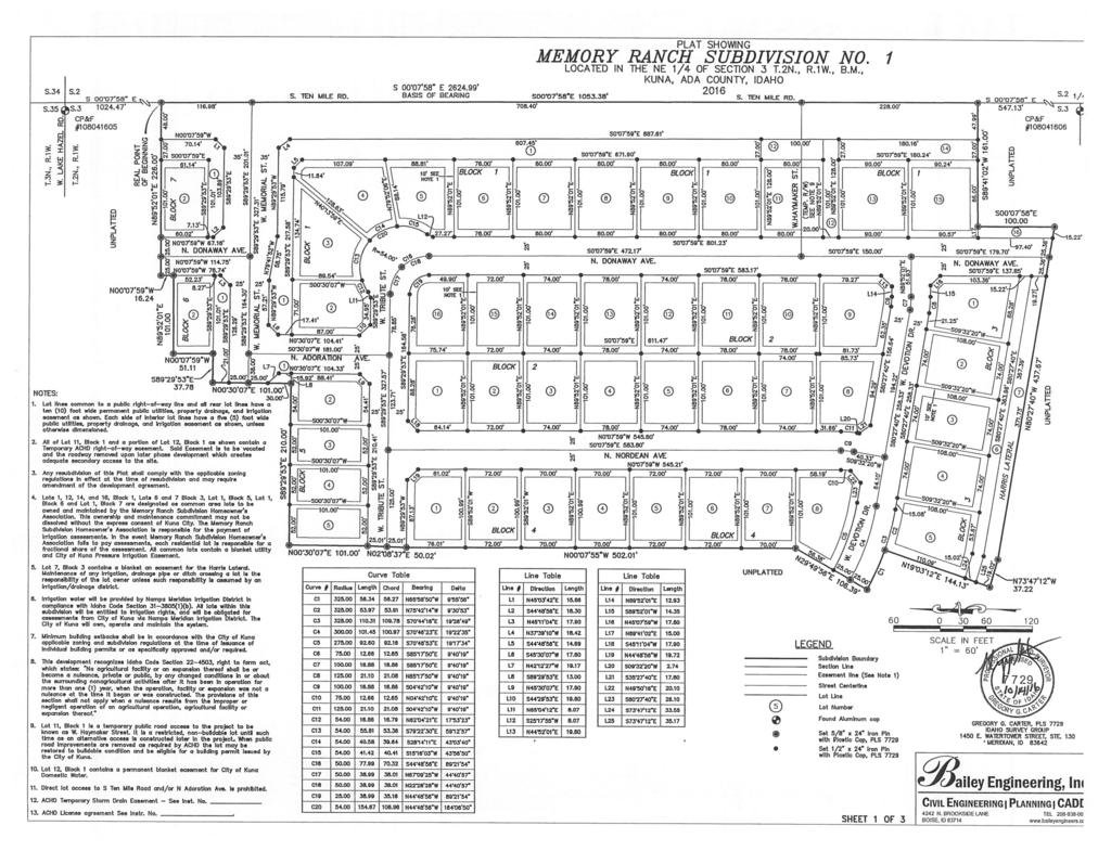
6 Development Services Department Project/File: Lead Agency: Site address: Applicant: Memory Ranch / KPP / AN / S The applicant is requesting annexation of approximately 10 acres, rezoning of approximately 135 acres to R-6, and subdivision of approximately 67 acres as part of Memory Ranch Subdivision. The proposed subdivision will include 261 residential lots and 20 common lots, located near the southwest corner of Lake Hazel Road and Ten Mile Road. City of Kuna SWC of Ten Mile Road and Lake Hazel Road Jane Suggs Suggs Community Solutions 200 Louisa St. Boise, ID Representative: Trilogy Development 2358 S. Titanium Pl. Meridian, ID Staff Contact: Austin Miller Planner I Phone: amiller@achdidaho.org A. Findings of Fact 1. Description of Application: The applicant is requesting annexation of approximately 10 acres, rezoning of approximately 135 acres to R-6, and subdivision of approximately 67 acres as part of Memory Ranch subdivision. The proposed subdivision will include 261 residential lots and 20 common lots, located near the southwest corner of Lake Hazel Road and Ten Mile Road. 2. Description of Adjacent Surrounding Area: Direction Land Use Zoning North Rural-Urban Transition RUT South Rural Residential RR East Rural Residential RR West Rural Residential RR 3. Site History: ACHD has not previously reviewed this site for a development application. 4. New Center Lane Miles: The proposed development includes approximately 1.8 lane miles of new public road. 1 Memory Ranch / KPP / S
7 5. Impact Fees: There will be an impact fee that is assessed and due prior to issuance of any building permits. The assessed impact fee will be based on the impact fee ordinance that is in effect at that time. 6. Capital Improvements Plan/ Integrated Five Year Work Plan: The intersection of Ten Mile Road and Amity Road is scheduled in the IFYWP to be reconstructed as a roundabout in Lake Hazel Road is listed in the CIP to be widened to 5-lanes from Ten Mile Road to Black Cat Road between 2027 and Ten Mile Road is listed in the CIP to be widened to 5-lanes from Columbia Road to Lake Hazel Road between 2027 and The intersection of Lake Hazel Road and Ten Mile Road is listed in the CIP to be reconstructed as a dual-lane roundabout with a southbound right turn bypass lane between 2022 and The intersection of Ten Mile Road and Amity Road is listed in the CIP to be widened to 7-lanes on the north leg, 7-lanes on the south, 7-lanes east, and 7-lanes on the west leg, and signalized between 2027 and B. Traffic Findings for Consideration 1. Trip Generation: This development is estimated to generate 2,494 vehicle trips per day; 196 vehicle trips per hour in the AM peak hour and 263 vehicle trips per hour in the PM peak hour, based on the traffic impact study. 2. Traffic Impact Study Thompson Engineers prepared a traffic impact study for the proposed Memory Ranch Subdivision. Below is an executive summary of the findings as presented by Thompson Engineers. The following executive summary is not the opinion of ACHD staff. ACHD has reviewed the submitted traffic impact study for consistency with ACHD policies and practices, and may have additional requirements beyond what is noted in the summary. ACHD Staff comments on the submitted traffic impact study can be found below under staff comments. Proposed Development: The project is a residential development of approximately 262 single family dwelling units. The final site plan was not finalized at the time of this report. The site is expected to access the transportation system via Lake Hazel Road ad Ten Mile Road. Future connectivity will be provided to the southwest. Study Area: The area of influence is anticipated to be west Ada County, Idaho, including the City of Kuna. The primary impact will be along Lake Hazel toad and Ten Mile Road. The study area will include the following intersections. Ten Mile Road and Lake Hazel Road Linder Road and Lake Hazel Road Amity Road and Ten Mile Road Conclusions: Below are the findings of the report: The site will access the transportation system via Lake hazel road, and Ten mile Road. The intersection of Lake Hazel Road and Linder Road will operate at acceptable levels of service under background and total traffic conditions in the build out year. The critical peak hour is in the PM peak hour. 2 Memory Ranch / KPP / S
8 The intersection of Ten Mile Road and Amity Road will operate at unacceptable levels of service under background and total traffic conditions in the build out year as an all way stop controlled intersection. The critical peak hour is in the PM peak hour. The ACHD Five Year Improvement plan includes reconstruction of this intersection to a roundabout. As a roundabout, the intersection will operate at an acceptable level of service in both the background and total traffic conditions. If we add traffic from approved off site developments to the existing traffic at the intersection of Ten Mile and Amity, we estimate that the intersection will operate at a poor LOS F. However, the subdivisions have not yet been approved and may not be at full build out prior to In the PM peak hour, the intersection will operate at LOS F with an additional 25 vehicles in the southbound through movement and 12 additional vehicles in the northbound through movement. The AM Peak hour has much more capacity available. Since the roundabout is a scheduled project, this intersection will only operate at a poor level of service for a year or two. The intersection of Lake Hazel Road and Ten mile Road will operate at acceptable levels of service under background and total traffic condition in the build out year as an all way stop controlled intersection. The critical peak hour is in the PM peak hour. Ten Mile Road is expected to operate at an acceptable better than LOS D in the build out year based on the ACHD policy of arterial roads. Lake Hazel Road is expected to operate at an acceptable better than LOS D in the build out year based on the ACHD policy for arterial roads. Lake Hazel Road is identified as a future primary east-west arterial roadway. The proposed site plan provides good circulation. Only one road is anticipated to exceed 1,000 vpd and there are no front-on houses on this segment. This road should be constructed to collector standards. The site access point on Lake Hazel road is approximately ¼ mile form Ten Mile Road, and is in conformance with ACHD access standards. The north site access point on Ten Mile road is approximately 1,000 feet south of Lake Hazel Road, and is in conformance with ACHD access standards. The south access point on Ten Mile Road is approximately 900 feet south of the north entrance, and is in conformance with ACHD access standards. This access is intended to be temporary, and will be closed upon the extension of the east-west mid mile collector road at Ten Mile Road. 3. Condition of Area Roadways Traffic Count is based on Vehicles per hour (VPH) Roadway Frontage Functional Classification PM Peak Hour Traffic Count PM Peak Hour Level of Service Principal Better than Lake Hazel Rd. 2,2010-feet 54 Arterial E Better than Ten Mile Rd. 1,660-feet Minor Arterial 308 D * Acceptable level of service for a two-lane principal arterial is E (690 VPH). * Acceptable level of service for a two-lane minor arterial is D (550 VPH). Existing Plus Project Better than E Better than D 4. Average Daily Traffic Count (VDT) Average daily traffic counts are based on ACHD s most current traffic counts. The average daily traffic count for Lake Hazel Road west of Ten Mile Road was 640 on January 26, The average daily traffic count for Ten Mile Road north of Columbia Road was 3,680 on February 28, Memory Ranch / KPP / S
9 C. Findings for Consideration 1. Ten Mile Road and Amity Road Intersection a. TIS Findings: Under background and total traffic conditions in the build out year, the intersection of Ten Mile Road and Amity Road will operate at unacceptable levels of service as an all way stop controlled intersection. The critical peak hour is in the PM peak hour. The ACHD Five Year Improvement plan includes reconstruction of this intersection to a roundabout. As a roundabout, the intersection will operate at an acceptable level of service in both the background and total traffic conditions. With traffic added from approved and proposed developments in the area, it is estimated that the intersection will operate at LOS F. However, not all of the subdivisions included in this TIS have been approved and may not be fully built out prior to In the PM peak hour, the intersection will operate at LOS F with an additional 25 vehicles in the southbound through movement and 12 additional vehicles in the northbound through movement. The AM Peak hour has much more capacity available. Since the roundabout is a scheduled project, this intersection will only operate at a poor level of service for a year or two, IF all of the approved and proposed developments are built out. PM Peak Hour Intersection Analysis Summary (assuming roundabout in 2019) LOS Summary PM Peak Hour Conditions Existing Background Total Delay s/v v/c LOS Delay s/v v/c LOS Delay s/v v/c LOS Amity/Ten Mile 43.2 E 16.2 C 18.9 C NB Approach C B B SB Approach F C D EB Approach C B B WB Approach D B B b. Policy: Level of Service Standards The TIS shall evaluate the potential impact of a specific development on the existing system. Acceptable level of service standards for each roadway segment and/or intersection evaluated shall be in accordance with Table 2 and Table 3. For all roadway segments the minimum acceptable projected level of service shall be LOS E for Principal Arterials and LOS D for Minor Arterials and Collectors. The acceptable level of service for all intersections should be based on a maximum Volume to Capacity (V/C) ratio of.90. The projected traffic shall include the background traffic and the projected site traffic. 4 Memory Ranch / KPP / S
10 c. Applicant Proposal: The applicant is not proposing any improvements to the intersection of Ten Mile Road and Amity Road, which is located one mile north of the site. d. Staff Comments/Recommendations: The Ten Mile Road and Amity Road intersection is listed in the adopted IFYWP and the draft for the updated IFYWP to be reconstructed as a roundabout in The intersection is currently operating at capacity. The intersection will operate at LOS F under current conditions and with the proposed development traffic added. Typically, when a roadway or intersection adjacent to a development is at or above an acceptable level of service staff recommends that improvements be made to mitigate the additional traffic to be generated by the development, or that the developer wait until ACHD makes improvements, as scheduled in the CIP or IFYWP. The southbound thru movement is the only leg of the intersection that operates at LOS F. In this case, improvements include the reconstruction of the Ten Mile Road and Amity Road intersection. However, given timing of the development build out (estimated ) in relation to the intersection project (2019), and the costs associated with reconstructing the intersection (in excess of $1,200,000), accompanied with the aforementioned fact that the intersection is currently at capacity, it should not be necessary for the applicant to construct the improvements. Additionally, rightof-way acquisition is necessary for construction of the project, and because the intersection is located one mile north of the site, the applicant does not control or own parcels adjacent to the intersection project. Staff recommends a waiver of District Policy Level of Service Standards due to the reasons previously discussed. This allows the project to move forward with the understanding that the intersection of Ten Mile Road and Amity Road will be reconstructed in 2019, consistent with the IFYWP. 2. Lake Hazel Road a. Existing Conditions: Lake Hazel Road is improved with 2-travel lanes and no curb, gutter or sidewalk abutting the site. There is 26-feet of pavement (13-feet from centerline), within 50- feet of right-of-way for Lake Hazel Road (25-feet from centerline). 5 Memory Ranch / KPP / S
11 b. Policy: Arterial Roadway Policy: District Policy states that the developer is responsible for improving all street frontages adjacent to the site regardless of whether or not access is taken to all of the adjacent streets. Master Street Map and Typology Policy: District Policy states that the design of improvements for arterials shall be in accordance with District standards, including the Master Street Map and Livable Streets Design Guide. The developer or engineer should contact the District before starting any design. Street Section and Right-of-Way Width Policy: District Policies & state that the standard 5-lane street section shall be 72-feet (back-of-curb to back-of-curb) within 96-feet of right-of-way. This width typically accommodates two travel lanes in each direction, a continuous center left-turn lane, and bike lanes on a minor arterial and a safety shoulder on a principal arterial. Right-of-Way Dedication: District Policy states that The District will provide compensation for additional right-of-way dedicated beyond the existing right-of-way along arterials listed as impact fee eligible in the adopted Capital Improvements Plan using available impact fee revenue in the Impact Fee Service Area. No compensation will be provided for right-of-way on an arterial that is not listed as impact fee eligible in the Capital Improvements Plan. The District may acquire additional right-of-way beyond the site-related needs to preserve a corridor for future capacity improvements, as provided in Section Sidewalk Policy: District Policy requires a concrete sidewalk at least 5-feet wide to be constructed on both sides of all arterial streets. A parkway strip at least 6-feet wide between the back-of-curb and street edge of the sidewalk is required to provide increased safety and protection of pedestrians. Consult the District s planter width policy if trees are to be placed within the parkway strip. Sidewalks constructed next to the back-of-curb shall be a minimum of 7-feet wide. Detached sidewalks are encouraged and should be parallel to the adjacent roadway. Meandering sidewalks are discouraged. A permanent right-of-way easement shall be provided if public sidewalks are placed outside of the dedicated right-of-way. The easement shall encompass the entire area between the rightof-way line and 2-feet behind the back edge of the sidewalk. Sidewalks shall either be located wholly within the public right-of-way or wholly within an easement. Frontage Improvements Policy: District Policy states that the developer shall widen the pavement to a minimum of 17-feet from centerline plus a 3-foot wide gravel shoulder adjacent to the entire site. Curb, gutter and additional pavement widening may be required (See Section ). ACHD Master Street Map: ACHD Policy Section requires the Master Street Map (MSM) guide the right-of-way acquisition, arterial street requirements, and specific roadway features required through development. This segment of Arterial Road is designated in the MSM as a Residential Mobility Arterial with 5-lanes within 100-feet of right-of-way. c. Applicant Proposal: The applicant is proposing to dedicate 50-feet of right-of way from centerline on Ten Mile Road abutting the site, and proposing to improve Lake Hazel Road with detached sidewalk. d. Staff Comments/Recommendations: The applicant should be required to dedicate 50-feet of right-of-way from centerline on Lake Hazel Road abutting the site. The applicant should be required to widen the pavement to a minimum of 17-feet from centerline plus a 3-foot wide 6 Memory Ranch / KPP / S
12 gravel shoulder, and should construct a 5-foot wide (minimum) detached concrete sidewalk along Lake Hazel Road abutting the site. 3. Ten Mile Road a. Existing Conditions: Ten Mile Road is improved with 2-travel lanes and no curb, gutter or sidewalk abutting the site. There is 26-feet of pavement (13-feet from centerline), within 50- feet of right-of-way for Ten Mile Road (25-feet from centerline). b. Policy: Arterial Roadway Policy: District Policy states that the developer is responsible for improving all street frontages adjacent to the site regardless of whether or not access is taken to all of the adjacent streets. Master Street Map and Typology Policy: District Policy states that the design of improvements for arterials shall be in accordance with District standards, including the Master Street Map and Livable Streets Design Guide. The developer or engineer should contact the District before starting any design. Street Section and Right-of-Way Width Policy: District Policies & state that the standard 5-lane street section shall be 72-feet (back-of-curb to back-of-curb) within 96-feet of right-of-way. This width typically accommodates two travel lanes in each direction, a continuous center left-turn lane, and bike lanes on a minor arterial and a safety shoulder on a principal arterial. Right-of-Way Dedication: District Policy states that The District will provide compensation for additional right-of-way dedicated beyond the existing right-of-way along arterials listed as impact fee eligible in the adopted Capital Improvements Plan using available impact fee revenue in the Impact Fee Service Area. No compensation will be provided for right-of-way on an arterial that is not listed as impact fee eligible in the Capital Improvements Plan. The District may acquire additional right-of-way beyond the site-related needs to preserve a corridor for future capacity improvements, as provided in Section Sidewalk Policy: District Policy requires a concrete sidewalk at least 5-feet wide to be constructed on both sides of all arterial streets. A parkway strip at least 6-feet wide between the back-of-curb and street edge of the sidewalk is required to provide increased safety and protection of pedestrians. Consult the District s planter width policy if trees are to be placed within the parkway strip. Sidewalks constructed next to the back-of-curb shall be a minimum of 7-feet wide. Detached sidewalks are encouraged and should be parallel to the adjacent roadway. Meandering sidewalks are discouraged. A permanent right-of-way easement shall be provided if public sidewalks are placed outside of the dedicated right-of-way. The easement shall encompass the entire area between the rightof-way line and 2-feet behind the back edge of the sidewalk. Sidewalks shall either be located wholly within the public right-of-way or wholly within an easement. Frontage Improvements Policy: District Policy states that the developer shall widen the pavement to a minimum of 17-feet from centerline plus a 3-foot wide gravel shoulder adjacent to the entire site. Curb, gutter and additional pavement widening may be required (See Section ). ACHD Master Street Map: ACHD Policy Section requires the Master Street Map (MSM) guide the right-of-way acquisition, arterial street requirements, and specific roadway features required through development. This segment of Ten Mile Road is designated in the MSM with 5-lanes. 7 Memory Ranch / KPP / S
13 c. Applicant Proposal: The applicant is proposing to dedicate 50-feet of right-of way from centerline on Ten Mile Road abutting the site, and proposing to improve Ten Mile Road with detached sidewalk. d. Staff Comments/Recommendations: The applicant should be required to dedicate 48-feet of right-of-way from centerline on Ten Mile Road abutting the site, and should widen the pavement to a minimum of 17-feet from centerline plus a 3-foot wide gravel shoulder, and construct a 5-foot wide (minimum) detached concrete sidewalk along Ten Mile Road abutting the site. 4. Internal Local Streets a. Existing Conditions: There are no roads constructed internal to the site. b. Policy: Local Roadway Policy: District Policy states that the developer is responsible for improving all local street frontages adjacent to the site regardless of whether or not access is taken to all of the adjacent streets. Street Section and Right-of-Way Policy: District Policy states that right-of-way widths for all local streets shall generally not be less than 50-feet wide and that the standard street section shall be 36-feet (back-of-curb to back-of-curb). The District will consider the utilization of a street width less than 36-feet with written fire department approval. Standard Urban Local Street 36-foot to 33-foot Street Section and Right-of-way Policy: District Policy states that the standard street section shall be 36-feet (back-of-curb to back-of-curb) for developments with any buildable lot that is less than 1 acre in size. This street section shall include curb, gutter, and minimum 5-foot concrete sidewalks on both sides and shall typically be within 50-feet of right-of-way. The District will also consider the utilization of a street width less than 36-feet with written fire department approval. Most often this width is a 33-foot street section (back-of-curb to backof-curb) for developments with any buildable lot that is less than 1 acre in size. Continuation of Streets Policy: District Policy states that an existing street, or a street in an approved preliminary plat, which ends at a boundary of a proposed development shall be extended in that development. The extension shall include provisions for continuation of storm drainage facilities. Benefits of connectivity include but are not limited to the following: Reduces vehicle miles traveled. Increases pedestrian and bicycle connectivity. Increases access for emergency services. Reduces need for additional access points to the arterial street system Promotes the efficient delivery of services including trash, mail and deliveries. Promotes appropriate intra-neighborhood traffic circulation to schools, parks, neighborhood commercial centers, transit stops, etc. Promotes orderly development. Sidewalk Policy: District Policy states that five-foot wide concrete sidewalk is required on both sides of all local street, except those in rural developments with net densities of one dwelling unit per 1.0 acre or less, or in hillside conditions where there is no direct lot frontage, in which case a sidewalk shall be constructed along one side of the street. Some local jurisdictions may require wider sidewalks. The sidewalk may be placed next to the back-of-curb. Where feasible, a parkway strip at least 8-feet wide between the back-of-curb and the street edge of the sidewalk is recommended to 8 Memory Ranch / KPP / S
14 provide increased safety and protection of pedestrians and to allow for the planting of trees in accordance with the District s Tree Planting Policy. If no trees are to be planted in the parkway strip, the applicant may submit a request to the District, with justification, to reduce the width of the parkway strip. Detached sidewalks are encouraged and should be parallel to the adjacent roadway. Meandering sidewalks are discouraged. A permanent right-of-way easement shall be provided if public sidewalks are placed outside of the dedicated right-of-way. The easement shall encompass the entire area between the rightof-way line and 2-feet behind the back edge of the sidewalk. Sidewalks shall either be located wholly within the public right-of-way or wholly within an easement. Landscape Medians Policy: District policy states that landscape medians are permissible where adequate pavement width is provided on each side of the median to accommodate the travel lanes and where the following is provided: The median is platted as right-of-way owned by ACHD. The width of an island near an intersection is 12-feet maximum for a minimum distance of 150-feet. Beyond the 150-feet, the island may increase to a maximum width of 30-feet. At an intersection that is signalized or is to be signalized in the future, the median width shall be reduced to accommodate the necessary turn lane storage and tapers. The Developer or Homeowners Association shall apply for a license agreement if landscaping is to be placed within these medians. The license agreement shall contain the District s requirements of the developer including, but not limited to, a hold harmless clause; requirements for maintenance by the developer; liability insurance requirements; and restrictions. Vertical curbs are required around the perimeter of any raised median. Gutters shall slope away from the curb to prevent ponding. c. Applicant s Proposal: The applicant is proposing to construct the internal local roads as 36- foot street sections within 52-feet of right-of way, complete with curb, gutter and 5-foot wide sidewalk. Memory Way south of Lake Hazel Road is proposed to be constructed as a 54-foot street section within 80-feet of right-of-way, including a landscape median, vertical curb, gutter, and sidewalk. Memory Way tapers to the standard 36-foot street section north of Remembrance Drive. Memorial Street between Ten Mile Road and Donaway Avenue is proposed as a 50-foot street section within 70-feet of right-of-way, including a landscape median, vertical curb, gutter, and sidewalk. The applicant is proposing to construct knuckles throughout the site. The knuckles are all proposed to have 48-foot radii. d. Staff Comments/Recommendations: The applicant s proposal meets district policy and should be approved as proposed. Landscape medians should be platted as right-of-way owned by ACHD. The medians are approved up to the 12-foot maximum width. Vertical curbs are required around the perimeter of any raised median. Gutters shall slope away from the curb to prevent ponding. The applicant should be required to provide 21-foot wide travel lanes on each side of the medians, as proposed. 9 Memory Ranch / KPP / S
15 A license agreement is required for all landscaping within ACHD right-of-way. The license agreement shall contain the District s requirements of the developer including, but not limited to, a hold harmless clause; requirements for maintenance by the developer; liability insurance requirements; and restrictions. 5. Roadway Offsets a. Existing Conditions: There are no public roads constructed internal to the site. b. Policy: Local Street Intersection Spacing on Principal Arterials: District policy states that new local streets should not typically intersect arterials. Local streets should typically intersect collectors. If it is necessary, as determined by ACHD, for a local street to intersect an arterial, the minimum allowable offset shall be 1,320-feet as measured from all other existing roadways as identified in Table 1b ( ). Local Street Intersection Spacing on Minor Arterials: District policy states that new local streets should not typically intersect arterials. Local streets should typically intersect collectors. If it is necessary, as determined by ACHD, for a local street to intersect an arterial, the minimum allowable offset shall be 660-feet as measured from all other existing roadways as identified in Table 1a ( ). Collector Offset Policy: District policy states that the optimum spacing for new signalized collector roadways intersecting arterial roadways is one half-mile. Local Offset Policy: District policy , requires local roadways to align or offset a minimum of 330-feet from a collector roadway (measured centerline to centerline). District policy , requires local roadways to align or provide a minimum offset of 125- feet from any other street (measured centerline to centerline). c. Applicant s Proposal: The applicant is proposing to locate Memory Way to intersect Lake Hazel Road approximately 1,300-feet west of Ten Mile Road (measured centerline to centerline). The applicant is proposing to locate Memorial Street to intersect Ten Mile Road approximately 1,000-feet south of Lake Hazel Road, and Haymaker Street to temporarily intersect Ten Mile Road approximately 1,900-feet south of Lake Hazel Road (measured centerline to centerline). All internal roads are proposed to align with or offset all other roads at distances greater than 125-feet. d. Staff Comments/Recommendations: Memory Way is proposed to intersect Lake Hazel Road approximately ¼ mile west of Ten Mile Road. This location should be approved as proposed. Memorial Street intersecting Ten Mile Road meets District policy and should be approved as proposed. The applicant has proposed to construct Haymaker Road as a 36-foot wide temporary access road onto Ten Mile Road, located approximately 1,900-feet south of Lake Hazel Road (measured centerline to centerline). The temporary access is proposed to provide additional access to the development and is proposed to be closed once the planned future collector street is constructed. Staff is supportive of the applicant s proposal and recommends that a temporary right-of-way easement be provided for the 36-foot wide temporary access road. The easement would be released after the planned future collector is constructed. 10 Memory Ranch / KPP / S
16 6. Stub Streets a. Existing Conditions: There are no public roads existing internal to the site or stubbed to the site. b. Policy: Stub Street Policy: District policy states that stub streets will be required to provide circulation or to provide access to adjoining properties. Stub streets will conform with the requirements described in Section , except a temporary cul-de-sac will not be required if the stub street has a length no greater than 150-feet. A sign shall be installed at the terminus of the stub street stating that, "THIS ROAD WILL BE EXTENDED IN THE FUTURE. In addition, stub streets must meet the following conditions: A stub street shall be designed to slope towards the nearest street intersection within the proposed development and drain surface water towards that intersection; unless an alternative storm drain system is approved by the District. The District may require appropriate covenants guaranteeing that the stub street will remain free of obstructions. Temporary Dead End Streets Policy: District policy requires that the design and construction for cul-de-sac streets shall apply to temporary dead end streets. The temporary cul-de-sac shall be paved and shall be the dimensional requirements of a standard cul-de-sac. The developer shall grant a temporary turnaround easement to the District for those portions of the cul-de-sac which extend beyond the dedicated street right-of-way. In the instance where a temporary easement extends onto a buildable lot, the entire lot shall be encumbered by the easement and identified on the plat as a non-buildable lot until the street is extended. c. Applicant Proposal: The applicant is proposing to construct 3 stub streets. Donaway Avenue is proposing to stub to the northeast corner of the site, as well as the southeast corner of the site abutting the Harris lateral canal. Salutation Street is proposed to stub west of the site along the Harris Lateral canal. d. Staff Comments/Recommendations: The applicant s proposal should be approved as proposed. The applicant should be required to provide a road trust deposit for half the cost of the extension of Donaway Avenue over Harris Lateral. Typically when a stub street is proposed to stub to a canal and the site s property line extends to the middle of the canal the applicant is required to provide a road trust deposit for half the cost of the extension of the street over the canal, as is the case with Salutation Street and Donaway Avenue. In lieu of providing a road trust deposit for Salutation Street, the applicant has the option to enter into a Development Agreement (DA) which would require the construction of the bridge crossing of the Harris Lateral when the parcel on the west side of the canal develops. The option for the DA in lieu of the road trust deposit is because the applicant owns the property on both sides of the canal at the proposed Salutation Street crossing. The parcel west of the canal that the bridge would connect to is large enough (approximately 60 acres) to fund the bridge construction. Staff recommends that the applicant and ACHD enter into a DA which would be recorded against the approximately 60 acre parcel west of Harris Lateral. This will ensure that a bridge is constructed when the parcel west of the canal develops regardless of who owns the property at that time. 11 Memory Ranch / KPP / S
17 The DA should identify that when the parcel to the west of the canal develops that the bridge crossing of Harris Lateral will be constructed. The applicant should be required to provide a preliminary design for the bridge crossing to show that grades will work as part of plan approval for Salutation Street. In order to ensure the bridge is constructed when the parcel west of the Harris Lateral develops, the DA must be in place and all conditions of the DA satisfied prior to signature of the first final plat within Memory Ranch Subdivision. 7. Tree Planters Tree Planter Policy: Tree Planter Policy: The District s Tree Planter Policy prohibits all trees in planters less than 8-feet in width without the installation of root barriers. Class II trees may be allowed in planters with a minimum width of 8-feet, and Class I and Class III trees may be allowed in planters with a minimum width of 10-feet. 8. Landscaping Landscaping Policy: A license agreement is required for all landscaping proposed within ACHD right-of-way or easement areas. Trees shall be located no closer than 10-feet from all public storm drain facilities. Landscaping should be designed to eliminate site obstructions in the vision triangle at intersections. District Policy requires a 40-foot vision triangle and a 3-foot height restriction on all landscaping located at an uncontrolled intersection and a 50-foot offset from stop signs. Landscape plans are required with the submittal of civil plans and must meet all District requirements prior to signature of the final plat and/or approval of the civil plans. 9. Other Access Lake Hazel Road and Ten Mile Road are classified as arterial roadways. Other than the access specifically approved with this application, direct lot access is prohibited to these roadways and should be noted on the final plat. D. Site Specific Conditions of Approval 1. Dedicate 50-feet of right-of-way from centerline on Lake Hazel Road abutting the site. 2. Dedicate 48-feet of right-of-way from centerline on Ten Mile Road abutting the site. 3. Widen the pavement of Lake Hazel Road and Ten Mile Road abutting the site to a minimum of 17-feet from centerline plus a 3-foot wide gravel shoulder. 4. Construct a minimum of 5-foot wide detached concrete sidewalk along Lake Hazel Road and Ten Mile Road abutting the site. 5. Construct the internal local roads as 36-foot street sections within 50-feet of right-of way, complete with curb, gutter and 5-foot wide sidewalk. Memory Way south of Lake Hazel Road is to be constructed as a 54-foot street section within 80- feet of right-of-way, including a landscape median, vertical curb, gutter, and sidewalk. Memory Way tapers to the standard 36-foot street section north of Remembrance Drive. Right-of-way at the northern portion of Memory Way should extend to the western property line, allowing access to the western parcel for future development. Memorial Street between Ten Mile Road and Donaway Avenue is to be a 50-foot street section within 70-feet of right-of-way, including a landscape median, vertical curb, gutter, and sidewalk. 6. Construct Haymaker Road as a 36-foot wide temporary access road onto Ten Mile Road, located approximately 1,900-feet south of Lake Hazel Road (measured centerline to ceterline). The temporary access is proposed to provide additional access to the development and is proposed to be closed once the planned future collector street is constructed. Staff recommends that a 12 Memory Ranch / KPP / S
18 temporary right-of-way easement be provided for Haymaker Street, the 36-foot wide temporary access road. The easement would be released after the planned future collector is constructed. 7. Landscape medians should be platted as right-of-way owned by ACHD. The medians are approved up to the 12-foot maximum width. Vertical curbs are required around the perimeter of any raised median. Gutters shall slope away from the curb to prevent ponding. Provide 21-foot wide travel lanes on each side of the medians. 8. Stub Donaway Avenue to the northeast corner of the site. A sign shall be installed at the terminus of the stub street stating that, "THIS ROAD WILL BE EXTENDED IN THE FUTURE." 9. Provide a road trust deposit for half the cost of the extension of Donaway Avenue over Harris Lateral. Road will be extended sign 10. The applicant and ACHD shall enter into a Development Agreement which would be recorded against the approximately 60 acre parcel west of Harris Lateral, for the bridge extension of Salutation Street spanning Harris Lateral. This will ensure that a bridge is constructed when the parcel west of the canal develops regardless of who owns the property at that time. A sign shall be installed at the terminus of the stub street stating that, "THIS ROAD WILL BE EXTENDED IN THE FUTURE." 11. A license agreement is required for all landscaping within ACHD right-of-way. 12. Payment of impacts fees are due prior to issuance of a building permit. 13. Comply with all Standard Conditions of Approval. E. Standard Conditions of Approval 1. All proposed irrigation facilities shall be located outside of the ACHD right-of-way (including all easements). Any existing irrigation facilities shall be relocated outside of the ACHD rightof-way (including all easements). 2. Private Utilities including sewer or water systems are prohibited from being located within the ACHD right-of-way. 3. In accordance with District policy, , the applicant may be required to update any existing non-compliant pedestrian improvements abutting the site to meet current Americans with Disabilities Act (ADA) requirements. The applicant s engineer should provide documentation of ADA compliance to District Development Review staff for review. 4. Replace any existing damaged curb, gutter and sidewalk and any that may be damaged during the construction of the proposed development. Contact Construction Services at (with file number) for details. 5. A license agreement and compliance with the District s Tree Planter policy is required for all landscaping proposed within ACHD right-of-way or easement areas. 6. All utility relocation costs associated with improving street frontages abutting the site shall be borne by the developer. 7. It is the responsibility of the applicant to verify all existing utilities within the right-of-way. The applicant at no cost to ACHD shall repair existing utilities damaged by the applicant. The applicant shall be required to call DIGLINE ( ) at least two full business days prior to breaking ground within ACHD right-of-way. The applicant shall contact ACHD Traffic Operations in the event any ACHD conduits (spare or filled) are compromised during any phase of construction. 8. Utility street cuts in pavement less than five years old are not allowed unless approved in writing by the District. Contact the District s Utility Coordinator at (with file numbers) for details. 13 Memory Ranch / KPP / S
19 9. All design and construction shall be in accordance with the ACHD Policy Manual, ISPWC Standards and approved supplements, Construction Services procedures and all applicable ACHD Standards unless specifically waived herein. An engineer registered in the State of Idaho shall prepare and certify all improvement plans. 10. Construction, use and property development shall be in conformance with all applicable requirements of ACHD prior to District approval for occupancy. 11. No change in the terms and conditions of this approval shall be valid unless they are in writing and signed by the applicant or the applicant s authorized representative and an authorized representative of ACHD. The burden shall be upon the applicant to obtain written confirmation of any change from ACHD. 12. If the site plan or use should change in the future, ACHD Planning Review will review the site plan and may require additional improvements to the transportation system at that time. Any change in the planned use of the property which is the subject of this application, shall require the applicant to comply with ACHD Policy and Standard Conditions of Approval in place at that time unless a waiver/variance of the requirements or other legal relief is granted by the ACHD Commission. F. Conclusions of Law 1. The proposed site plan is approved, if all of the Site Specific and Standard Conditions of Approval are satisfied. 2. ACHD requirements are intended to assure that the proposed use/development will not place an undue burden on the existing vehicular transportation system within the vicinity impacted by the proposed development. G. Attachments 1. Vicinity Map 2. Site Plan 3. Utility Coordinating Council 4. Development Process Checklist 5. Request for Reconsideration Guidelines 14 Memory Ranch / KPP / S

20 VICINITY MAP 15 Memory Ranch / KPP / S

21 SITE PLAN 16 Memory Ranch / KPP / S
22 Ada County Utility Coordinating Council Developer/Local Improvement District Right of Way Improvements Guideline Request Purpose: To develop the necessary avenue for proper notification to utilities of local highway and road improvements, to help the utilities in budgeting and to clarify the already existing process. 1) Notification: Within five (5) working days upon notification of required right of way improvements by Highway entities, developers shall provide written notification to the affected utility owners and the Ada County Utility Coordinating Council (UCC). Notification shall include but not be limited to, project limits, scope of roadway improvements/project, anticipated construction dates, and any portions critical to the right of way improvements and coordination of utilities. 2) Plan Review: The developer shall provide the highway entities and all utility owners with preliminary project plans and schedule a plan review conference. Depending on the scale of utility improvements, a plan review conference may not be necessary, as determined by the utility owners. Conference notification shall also be sent to the UCC. During the review meeting the developer shall notify utilities of the status of right of way/easement acquisition necessary for their project. At the plan review conference each company shall have the right to appeal, adjust and/or negotiate with the developer on its own behalf. Each utility shall provide the developer with a letter of review indicating the costs and time required for relocation of its facilities. Said letter of review is to be provided within thirty calendar days after the date of the plan review conference. 3) Revisions: The developer is responsible to provide utilities with any revisions to preliminary plans. Utilities may request an updated plan review meeting if revisions are made in the preliminary plans which affect the utility relocation requirements. Utilities shall have thirty days after receiving the revisions to review and comment thereon. 4) Final Notification: The developer will provide highway entities, utility owners and the UCC with final notification of its intent to proceed with right of way improvements and include the anticipated date work will commence. This notification shall indicate that the work to be performed shall be pursuant to final approved plans by the highway entity. The developer shall schedule a preconstruction meeting prior to right of way improvements. Utility relocation activity shall be completed within the times established during the preconstruction meeting, unless otherwise agreed upon. Notification to the Ada County UCC can be sent to: 50 S. Cole Rd. Boise 83707, or Visit iducc.com for notification information. 17 Memory Ranch / KPP / S
23 Development Process Checklist Items Completed to Date: Submit a development application to a City or to Ada County The City or the County will transmit the development application to ACHD The ACHD Planning Review Section will receive the development application to review The Planning Review Section will do one of the following: Send a No Review letter to the applicant stating that there are no site specific conditions of approval at this time. Write a Staff Level report analyzing the impacts of the development on the transportation system and evaluating the proposal for its conformance to District Policy. Write a Commission Level report analyzing the impacts of the development on the transportation system and evaluating the proposal for its conformance to District Policy. Items to be completed by Applicant: For ALL development applications, including those receiving a No Review letter: The applicant should submit one set of engineered plans directly to ACHD for review by the Development Review Section for plan review and assessment of impact fees. (Note: if there are no site improvements required by ACHD, then architectural plans may be submitted for purposes of impact fee assessment.) The applicant is required to get a permit from Construction Services (ACHD) for ANY work in the right-ofway, including, but not limited to, driveway approaches, street improvements and utility cuts. Pay Impact Fees prior to issuance of building permit. Impact fees cannot be paid prior to plan review approval. DID YOU REMEMBER: Construction (Non-Subdivisions) Driveway or Property Approach(s) Submit a Driveway Approach Request form to ACHD Construction (for approval by Development Services & Traffic Services). There is a one week turnaround for this approval. Working in the ACHD Right-of-Way Four business days prior to starting work have a bonded contractor submit a Temporary Highway Use Permit Application to ACHD Construction Permits along with: a) Traffic Control Plan b) An Erosion & Sediment Control Narrative & Plat, done by a Certified Plan Designer, if trench is >50 or you are placing >600 sf of concrete or asphalt. Construction (Subdivisions) Sediment & Erosion Submittal At least one week prior to setting up a Pre-Construction Meeting an Erosion & Sediment Control Narrative & Plan, done by a Certified Plan Designer, must be turned into ACHD Construction to be reviewed and approved by the ACHD Stormwater Section. Idaho Power Company Vic Steelman at Idaho Power must have his IPCO approved set of subdivision utility plans prior to Pre-Con being scheduled. Final Approval from Development Services is required prior to scheduling a Pre-Con. 18 Memory Ranch / KPP / S
24 Request for Appeal of Staff Decision 1. Appeal of Staff Decision: The Commission shall hear and decide appeals by an applicant of the final decision made by the Development Services Manager when it is alleged that the Development Services Manager did not properly apply this section , did not consider all of the relevant facts presented, made an error of fact or law, abused discretion or acted arbitrarily and capriciously in the interpretation or enforcement of the ACHD Policy Manual. a. Filing Fee: The Commission may, from time to time, set reasonable fees to be charged the applicant for the processing of appeals, to cover administrative costs. b. Initiation: An appeal is initiated by the filing of a written notice of appeal with the Secretary of Highway Systems, which must be filed within ten (10) working days from the date of the decision that is the subject of the appeal. The notice of appeal shall refer to the decision being appealed, identify the appellant by name, address and telephone number and state the grounds for the appeal. The grounds shall include a written summary of the provisions of the policy relevant to the appeal and/or the facts and law relied upon and shall include a written argument in support of the appeal. The Commission shall not consider a notice of appeal that does not comply with the provisions of this subsection. c. Time to Reply: The Development Services Manager shall have ten (10) working days from the date of the filing of the notice of appeal to reply to the notice of the appeal, and may during such time meet with the appellant to discuss the matter, and may also consider and/or modify the decision that is being appealed. A copy of the reply and any modifications to the decision being appealed will be provided to the appellant prior to the Commission hearing on the appeal. d. Notice of Hearing: Unless otherwise agreed to by the appellant, the hearing of the appeal will be noticed and scheduled on the Commission agenda at a regular meeting to be held within thirty (30) days following the delivery to the appellant of the Development Services Manager s reply to the notice of appeal. A copy of the decision being appealed, the notice of appeal and the reply shall be delivered to the Commission at least one (1) week prior to the hearing. e. Action by Commission: Following the hearing, the Commission shall either affirm or reverse, in whole or part, or otherwise modify, amend or supplement the decision being appealed, as such action is adequately supported by the law and evidence presented at the hearing. 19 Memory Ranch / KPP / S
BPP / SUB
 Development Services Department Project/File: Lead Agency: Site address: Millwell Place Subdivision/ BPP15-0031/ SUB15-0064 This is a preliminary plat application to allow for the development of 68 building
BOI / DRH S. 13 th Street Mixed use office/retail development with residential dormitory
 Jim D. Hansen, President Sara M. Baker, Vice President Rebecca W. Arnold, Commissioner Kent Goldthorpe, Commissioner Paul Woods, Commissioner October 21, 2015 To: Rick Nesser ISS River Partners, LLC 8312
 Development Services Department Project/File: Lead Agency: Site address: Fall Creek Subdivision (MPP-12-016) This is a preliminary plat application to subdivision approximately 110 acres into 296 residential
Development Services Department
 Kent Goldthorpe, President Paul Woods, Vice President Rebecca W. Arnold, Commissioner Sara M. Baker, Commissioner Jim D. Hansen, Commissioner July 21, 2016 Development Services Department To: From: ACHD
ACHD Board of Commissioners Stacey Yarrington, Planner III Tandem Ridge/ EPP / PP-07-16/ RZ-12-16/ CPA-01-16/ A-07-16
 Development Services Department DATE: December 14, 2016 TO: FROM: SUBJECT: ACHD Board of Commissioners Stacey Yarrington, Planner III Tandem Ridge/ EPP16-0012/ PP-07-16/ Executive Summary: This is an annexation,
 Development Services Department Project/File: Lead Agency: Site address: Aralar Park/SUB13-00048 This is a preliminary plat application to construct 55 buildable lots and 6 common lots on 12.67 acres.
BPP / SUB /CAR /PUD
 Development Services Department Project/File: Lead Agency: Site address: Roe Street Townhomes/ BPP16-0023/ SUB16-00046/CAR16-00023/PUD16-00022 This is a rezone, preliminary plat, and planned unit development
Development Services Department
 Kent Goldthorpe, President Paul Woods, Vice President Rebecca W. Arnold, Commissioner Sara M. Baker, Commissioner Jim D. Hansen, Commissioner July 28, 2016 Development Services Department To: From: ACHD
Committed to Service
 Development Services Department Committed to Service January 19, 2016 TO: FROM: SUBJECT: ACHD Board of Commissioners Mindy Wallace, AICP Planner III Kirsten Subdivision/BPP15-0023 Executive Summary: The
Committed to Service. Development Services. February 21, ACHD Commission. Mindy Wallace, AICP
 Committed to Service Sara M. Baker, President Rebecca W. Arnold, Vice President Jim D. Hansen, Commissioner Kent Goldthorpe, Commissioner Paul Woods, Commissioner February 21, 2018 Development Services
Committed to Service
 Committed to Service Paul Woods, President Rebecca W. Arnold, Vice President Sara M. Baker, Commissioner Jim D. Hansen, Commissioner Kent Goldthorpe, Commissioner September 19, 2017 Development Services
Committed to Service
 Committed to Service Kent Goldthorpe, President Paul Woods, Vice President Rebecca W. Arnold, Commissioner Sara M. Baker, Commissioner Jim D. Hansen, Commissioner May 24, 2017 Development Services TO:
Committed to Service
 Committed to Service Sara M. Baker, President Rebecca W. Arnold, Vice President Jim D. Hansen, Commissioner Kent Goldthorpe, Commissioner Paul Woods, Commissioner February 21, 2018 Development Services
Committed to Service
 Development Services Department Committed to Service June 30, 2014 TO: FROM: SUBJECT: ACHD Board of Commissioners Christy Little Planning Review Supervisor Victory Middle School/MCUP-14-003 DATE: July
Roadway Classification Design Standards and Policies. Pueblo, Colorado November, 2004
 Roadway Classification Design Standards and Policies Pueblo, Colorado November, 2004 Table of Contents Page Chapter 1. General Provisions 1.1 Jurisdiction 3 1.2 Purpose and Intent 3 1.3 Modification 3
Committed to Service
 Committed to Service Paul Woods, President Rebecca W. Arnold, Vice President Sara M. Baker, Commissioner Jim D. Hansen, Commissioner Kent Goldthorpe, Commissioner January 16, 2018 Development Services
2. Caven Ridge Estates Subdivision No. 1 adds 0.54 centerline miles to the ACHD roadway system.
 Kent Goldthorpe, President Paul Woods, Vice President Rebecca W. Arnold, Commissioner Sara M. Baker, Commissioner Jim D. Hansen, Commissioner October 12, 2016 Development Services Department To: From:
Committed to Service
 Development Services Department Committed to Service TO: FROM: Ada County Highway District Commissioners Mindy Wallace, AICP Planner III COMISSION HEARING: January 27, 2016 SUBJECT: Syringa Valley Specific
Subdivision Staff Report
 Subdivision Staff Report Subdivision Name Plano Road Subdivision File Number SUB07-00065 Approval Preliminary Plat Lead Agency Boise City Annexation Date Pending (CAR07-00042/DA) Comp. Plan Does Not Comply
This Chapter sets forth the minimum design, technical criteria and specifications to be used in the preparation of all roadway plans.
 4.1 GENERAL This Chapter sets forth the minimum design, technical criteria and specifications to be used in the preparation of all roadway plans. These Roadway Standards are for new construction and modification
December 2, ACHD Board of Commissioners. Lauren Watsek Planner I. PUD (Deep Green Condominiums) Executive Summary:
 Executive Summary:") Development Services Department December 2, 2013 TO: FROM: SUBJECT: ACHD Board of Commissioners Lauren Watsek Planner I PUD13-00013 (Deep Green Condominiums) Executive Summary: The applicant is requesting
Development Services Department December 2, 2013 TO: FROM: SUBJECT: ACHD Board of Commissioners Lauren Watsek Planner I PUD13-00013 (Deep Green Condominiums) Executive Summary: The applicant is requesting
2. The applicant is Corey Barton Homes, Inc. and the principal for the applicant is Corey D. Barton, President.
 Kent Goldthorpe, President Paul Woods, Vice President Rebecca W. Arnold, Commissioner Sara M. Baker, Commissioner Jim D. Hansen, Commissioner February 25, 2016 Development Services Department To: ACHD
T A B L E OF C O N T E N T S
 T A B L E OF C O N T E N T S PART III SUBDIVISION REGULATIONS OF THE DEPARTMENT OF PUBLIC WORKS, C & C D PAGE PAGE Responsibility for Development of Streets......... 29 Right-of-Way Widths...... 37 Purpose...........
SECTION 3 STREET DESIGN
 3.01 GENERAL SECTION 3 STREET DESIGN For purposes of geometric and structural design, streets shall be classified according to the following table. The City Engineer will determine the class of all proposed
Development Services Department
 Development Services Department Project/File: Lead Agency: Site address: Harris Ranch Specific Area Plan Text Amendments/ZOA14-00001 The applicant is requesting approval of a text amendment application
Access requests to County streets and roadways are processed through one of the following methods:
 13.1 GENERAL APPLICATION PROCESS Access requests to County streets and roadways are processed through one of the following methods: A. Planned Developments may set general locations for access points.
Street Paving and Sidewalk Policy
 City Commission Policy 600 Street Paving and Sidewalk Policy DEPARTMENT: Public Works DATE ADOPTED: June 7, 1995 DATE OF LAST REVISION: December 10, 2014 Policy No. 600.01 AUTHORITY: PASS City of Tallahassee-Leon
5.0 Roadway System Plan
 Southwest Boise Transportation Study Page 16 5.0 Roadway System Plan The Roadway System Plan outlines roadway improvements in the Initial Study Area. It forecasts future deficiencies on the arterial system,
MAJOR THOROUGHFARE PLAN
 MAJOR THOROUGHFARE PLAN Adopted by City Commission On November 21, 2005 Per Resolution No. 4420 Amendment to the Comprehensive Community Development Plan City of Hobbs City of Hobbs MAJOR THOROUGHFARE
Town of Siler City - Unified Development Ordinance ARTICLE XIV - Streets and Sidewalks
 ARTICLE XIV - Streets and Sidewalks 193 Street Classification (a) In all new subdivisions, streets that are dedicated to public use shall be classified as provided in 193(b) (1) The classification shall
CHAPTER 16 PEDESTRIAN FACILITIES DESIGN AND TECHNICAL CRITERIA TABLE OF CONTENTS
 CHAPTER 16 PEDESTRIAN FACILITIES DESIGN AND TECHNICAL CRITERIA TABLE OF CONTENTS Section Title Page 16.1 General... 16-1 16.1.1 AASHTO Reference... 16-1 16.1.2 ADA Requirements... 16-1 16.2 Sidewalks...
TRAFFIC STUDY GUIDELINES Clarksville Street Department
 TRAFFIC STUDY GUIDELINES Clarksville Street Department 9/1/2009 Introduction Traffic studies are used to help the city determine potential impacts to the operation of the surrounding roadway network. Two
TOWN OF CHAPEL HILL POLICY AND PROCEDURES FOR TRAFFIC CALMING MEASURES
 TOWN OF CHAPEL HILL POLICY AND PROCEDURES FOR TRAFFIC CALMING MEASURES (Adopted by the Town Council on June 30, 2004) (Revised December 6, 2010) (Revised February 8, 2016) POLICY AND PROCEDURES FOR TRAFFIC
4APNOIPF Vh, YII PTC CITY COUNCIL AGENDA REPORT. Honorable Mayor and City Council Members. 8K TH 63 River Crossing Bridge Replacement Project
 City of RE 4APNOIPF Vh, X` W\ YII PTC ING, CITY COUNCIL AGENDA REPORT Council Meeting Date: September 26, 2016 To: From: Agenda Item: Honorable Mayor and City Council Members Ron Rosenthal, Engineering
Citizens Handbook for Requesting Traffic Calming Devices
 Citizens Handbook for Requesting Traffic Calming Devices January 19, 2015 Table of Contents 1. PURPOSE... - 1-2. DEFINITIONS... - 2-3. GENERAL INFORMATION... - 3-3.1. ELIGIBILITY REQUIREMENTS... - 3-3.2.
WYDOT DESIGN GUIDES. Guide for. Non-NHS State Highways
 WYDOT DESIGN GUIDES Guide for Non-NHS State Highways 2014 GUIDE FOR Non-NATIONAL HIGHWAY SYSTEM (Non-NHS) STATE HIGHWAYS PRESERVATION REHABILITATION RECONSTRUCTION INTRODUCTION This Guide is directed to
Recommended Roadway Plan Section 2 - Land Development and Roadway Access
 Recommended Roadway Plan Section 2 - Land Development and Roadway Access SECTION 2 Land Development and Roadway Access 2.1 Land Use and Access Management The Federal Highway Administration (FHWA) defines
County of Greenville South Carolina. Traffic Calming Program Neighborhood Traffic Education Program and Speed Hump Program
 County of Greenville South Carolina Traffic Calming Program Neighborhood Traffic Education Program and Speed Hump Program (rev) August 2008 I. PURPOSE The potential negative impacts from vehicular traffic
WYDOT DESIGN GUIDES. Guide for. NHS Arterial (Non-Interstate)
") WYDOT DESIGN GUIDES Guide for NHS Arterial (Non-Interstate) 2014 GUIDE FOR NATIONAL HIGHWAY SYSTEM (NHS) HIGHWAYS (NHS ARTERIALS, Non-Interstate) PRESERVATION REHABILITATION RECONSTRUCTION INTRODUCTION
WYDOT DESIGN GUIDES Guide for NHS Arterial (Non-Interstate) 2014 GUIDE FOR NATIONAL HIGHWAY SYSTEM (NHS) HIGHWAYS (NHS ARTERIALS, Non-Interstate) PRESERVATION REHABILITATION RECONSTRUCTION INTRODUCTION
GWINNETT COUNTY DEPARTMENT OF TRANSPORTATION
 GWINNETT COUNTY DEPARTMENT OF TRANSPORTATION 1 of 7 June 20, 2007 GENERAL: The following guidelines shall be used in the determination of the requirement for left turn lanes for development projects and
COUNTY OF SONOMA PERMIT AND RESOURCE MANAGEMENT DEPARTMENT 2550 Ventura Avenue, Santa Rosa, CA (707) FAX (707)
 FAX (707)") COUNTY OF SONOMA PERMIT AND RESOURCE MANAGEMENT DEPARTMENT 2550 Ventura Avenue, Santa Rosa, CA 95403 (707) 565-1900 FAX (707) 565-1103 DATE: February 17, 2012 TO: Board of Supervisors FROM: Blake Hillegas,
COUNTY OF SONOMA PERMIT AND RESOURCE MANAGEMENT DEPARTMENT 2550 Ventura Avenue, Santa Rosa, CA 95403 (707) 565-1900 FAX (707) 565-1103 DATE: February 17, 2012 TO: Board of Supervisors FROM: Blake Hillegas,
Summary: Mercer County Princeton Avenue & Spruce Street Study January 2009
 Summary: Several recent studies have assessed potential development and redevelopment opportunities in the Mercer Crossing area of Trenton, Ewing, and Lawrence. This Princeton Avenue and Spruce Street
Committed to Service
 Development Services Department Committed to Service November 4, 2014 TO: FROM: SUBJECT: ACHD Board of Commissioners Mindy Wallace, AICP Planner III Village Charter School/ BOI14-0105/CUP14-00046/DRH14-000324
REMOVE BARRIERS TO, ENCOURAGE CREATION OF AND PROVIDE GUIDELINES FOR SAFE ROUTES (ALL DISTRICTS)
") Ordinance 2009-98 AN ORDINANCE OF THE BOARD OF SUPERVISORS OF PIMA COUNTY, ARIZONA; RELATING TO ZONING; AMENDING THE PIMA COUNTY ZONING CODE TITLE 18 BY AMENDING SECTION 18.03.020 (DEFINITIONS) TO ADD
Ordinance 2009-98 AN ORDINANCE OF THE BOARD OF SUPERVISORS OF PIMA COUNTY, ARIZONA; RELATING TO ZONING; AMENDING THE PIMA COUNTY ZONING CODE TITLE 18 BY AMENDING SECTION 18.03.020 (DEFINITIONS) TO ADD
Clackamas County Comprehensive Plan
 ROADWAYS The County s road system permits the movement of goods and people between communities and regions, using any of a variety of modes of travel. Roads provide access to virtually all property. They
Access Management Standards
 Access Management Standards Section 1: Application of Access Standards This chapter describes the Department's access management standards for access connections on the county roadway system. The standards
DRAFT - CITY OF MEDFORD TRANSPORTATION SYSTEM PLAN Roadway Cross-Sections
 Roadway Cross-Sections Medford s roadway cross-section standards apply to new and reconstructed roads. The crosssections take into consideration roadway function and operational characteristics, including
Information on display. Inside this handout. Triangle Area revisions. Project need displays. Preferred alternative on aerial maps
 Public information meeting #4 4 to 7 p.m., September 30, 2009 Hales Corners Welcome Thank you for attending this public information meeting for the WIS 100 Corridor Study. Your interest and comments are
MUNICIPALITY OF ANCHORAGE Traffic Department MEMORANDUM
 MUNICIPALITY OF ANCHORAGE DATE: MEMORANDUM TO: FROM: SUBJECT: Anchorage Contractors, Builders, Designers, and Land Owners Robert E. Kniefel, P.E., Municipal Traffic Engineer Municipal Driveway Standards
Driveway Design Criteria
 Design Manual Chapter 5 - Roadway Design 5L - Access Management 5L-4 Driveway Design Criteria A. General For efficient and safe operations, access drives and minor public street intersections can be improved
INTRODUCTION THOROUGHFARE SYSTEM CLASSIFICATIONS
 INTRODUCTION The thoroughfare plan will assist public officials in the development of a specialized system for efficient and safe movement of vehicular traffic while minimizing potential conflicts with
Highway 49, Highway 351 and Highway 91 Improvements Feasibility Study Craighead County
 Highway 49, Highway 351 and Highway 91 Improvements Feasibility Study Craighead County Executive Summary March 2015 Highway 49, Highway 351 and Highway 91 Improvements Feasibility Study Craighead County
Bradford s Landing. Preliminary Plan Abandonment AB753 & AB754 MONTGOMERY COUNTY PLANNING DEPARTMENT
 Bradford s Landing Preliminary Plan 120170060 Abandonment AB753 & AB754 1 Overview Staff recommends Approval of Preliminary Plan 120170060 with revised conditions and Adoption of the Resolution. 244 lots
Poor pavement condition Substandard Intersections. / Substandard bike/pedestrian/transit accommodations. Driveway access Environmental concerns
 Public Informational Meeting University Avenue (Allen Boulevard Segoe Road) March 23, 2011 City of Madison City of Middleton Village of Shorewood Hills Dane County Existing Roadway Conditions Poor pavement
TRAFFIC IMPACT STUDY CRITERIA
 Chapter 6 - TRAFFIC IMPACT STUDY CRITERIA 6.1 GENERAL PROVISIONS 6.1.1. Purpose: The purpose of this document is to outline a standard format for preparing a traffic impact study in the City of Steamboat
Villages of Pasadena Hills Financial Plan UPDATED Spring 2012 DRAFT
 36 37 38 39 40 41 42 43 44 45 46 Appendix B (Unchanged from January 2009 Adoption) 47 Projects Approved Prior to VOPH Comprehensive Plan Amendment Ashley Groves Chapel Creek Chapel Hill Farmington Hills
CHAPTER 4 TRANSPORTATION IMPACT STUDY TABLE OF CONTENTS
 CHAPTER 4 TRANSPORTATION IMPACT STUDY TABLE OF CONTENTS Section Title Page 4.1 Introduction... 4-1 4.1.1 General... 4-1 4.1.2 Applicant Responsibility... 4-1 4.1.3 Capacity and Safety Issues... 4-1 A.
State Street and Pierce Park Lane Intersection Concept Report
 State Street and Pierce Park Lane Intersection Prepared for September 2017 Prepared by CITATION Parametrix. 2017. State Street & Pierce Park Lane Intersection. Prepared by Parametrix, Boise, ID. September
5.0 ROADWAY DESIGN 5.1 INTRODUCTION
 SECTION 5 5.0 ROADWAY DESIGN 5.1 INTRODUCTION In the design of roadways, it is essential to account for all the components that may affect the efficiency and safety of the roadway network. The four (4)
Access Management Regulations and Standards
 Access Management Regulations and Standards Efficient highway operation Reasonable property access Concept of Access Management The way to manage access to land development while simultaneously preserving
SECTION 1 - TRAFFIC PLANNING
 SECTION 1 - TRAFFIC PLANNING 1.1 TRAFFIC OPERATIONS 1.1.1 Roadway Functional Classification The Multnomah County Comprehensive Framework Plan s Policy 34: Trafficways and the Functional Classification
PROJECT NO. 093 MA 199 H C. FEDERAL NO. xxxx WIKIEUP-WICKENBURG-PHOENIX HIGHWAY TEGNER STREET, ALTERNATIVE 10 PROJECT IMPROVEMENT
 PROJECT NO. 093 MA 199 H 5807 01C FEDERAL NO. xxxx WIKIEUP-WICKENBURG-PHOENI HIGHWAY TEGNER STREET, ALTERNATIVE 10 PROJECT IMPROVEMENT (INTERSECTION IMPROVEMENT) US 93/US 60 FINAL PROJECT ASSESSMENT April
SAN FRANCISCO MUNICIPAL TRANSPORTATION AGENCY BOARD OF DIRECTORS. RESOLUTION No
 SAN FRANCISCO MUNICIPAL TRANSPORTATION AGENCY BOARD OF DIRECTORS RESOLUTION No. 15-031 WHEREAS, Transportation Code Division II, Section 909 authorizes the Director of Transportation to install and permit
Classification Criteria
 SCHEDULE D TO RECOMMENDED OFFICIAL PLAN AMENDMENT NO. 40 SCHEDULE C-4 Road Criteria Criteria Traffic Service Objective Land Service/Access Typical Daily Traffic Volume Flow characteristics Travel Speed
Ordinance No ORDINANCE NUMBER 238
 Ordinance No. 238 1 ORDINANCE NUMBER 238 BY THE ADA COUNTY HIGHWAY DISTRICT BOARD OF COMMISSIONERS: SARA M. BAKER, REBECCA W. ARNOLD, JIM D. HANSEN, KENT GOLDTHORPE, PAUL WOODS AN ORDINANCE AMENDING TITLE
4.11 TRANSPORTATION/CIRCULATION
 4.11 TRANSPORTATION/CIRCULATION This section was developed using information from a Traffic Analysis Report prepared for the project by OEG, Inc. (2010), the Paradiso del Mare Ocean and Inland Estates
4.0 ACCESS CONTROL PLAN - SH 14 (JEFFERSON STREET/RIVERSIDE AVENUE)
") 4.1 Existing Conditions Roadway Physical Characteristics Typical Sections Jefferson Street 4.0 ACCESS CONTROL PLAN - SH 14 (JEFFERSON STREET/RIVERSIDE AVENUE) The existing typical cross-section for SH
4.1 Existing Conditions Roadway Physical Characteristics Typical Sections Jefferson Street 4.0 ACCESS CONTROL PLAN - SH 14 (JEFFERSON STREET/RIVERSIDE AVENUE) The existing typical cross-section for SH
5. RUNNINGWAY GUIDELINES
 5. RUNNINGWAY GUIDELINES These guidelines should be considered collectively when making runningway decisions. A runningway is the linear component of the transit system that forms the right-of-way reserved
Table 1: Recommended Interim Improvement and Long Term Improvement/ROW Preservation Proposed Improvements. Recommended Interim Improvement
 Rebecca W. Arnold, President Sara M. Baker, Vice President John S. Franden, Commissioner Carol A. McKee, Commissioner Mitchell Jaurena, Commissioner June 19, 2012 Planning & Programming Department TO:
RZC Appendix 8A Marymoor Subarea Street Requirements
 RZC Appendix 8A Marymoor Subarea Street Requirements For additional design details for Marymoor Subarea infrastructure, refer to the 2017 Marymoor Subarea Infrastructure Planning Report. STREET REQUIREMENTS
Inspector MUST Sign and Date Each Inspection
 Work Area: Applicant: Mercer County Department of Transportation - Highways Division Application and Permit for Road Work in Mercer County, New Jersey NO. East Windsor Ewing Hamilton Hopewell Lawrence
TRAFFIC CALMING GUIDE FOR TORONTO CITY OF TORONTO TRANSPORTATION SERVICES DIVISION
 TRAFFIC CALMING GUIDE FOR TORONTO CITY OF TORONTO TRANSPORTATION SERVICES DIVISION CITY OF TORONTO TRANSPORTATION SERVICES DIVISION 2016 TRAFFIC CALMING GUIDE FOR TORONTO TABLE OF CONTENTS Introduction
10.0 CURB EXTENSIONS GUIDELINE
 10.0 CURB EXTENSIONS GUIDELINE Road Engineering Design Guidelines Version 1.0 March 2017 City of Toronto, Transportation Services City of Toronto Page 0 Background In early 2014, Transportation Services
Americans with Disabilities Act Transition Plan for Public Right-of-Way Improvements
 Americans with Disabilities Act Transition Plan for Public Right-of-Way Improvements Prepared by: Public Works Department Engineering Division October 2015 Table of Contents Section I Introduction.. 3
Fleur Drive Reconstruction
 Fleur Drive Reconstruction October 29, 2018 1 Agenda: Fleur Drive Reconstruction Project Scope & Cost Overview Fleur Drive Cross Section Elements - Travel Lane Widths - Sidewalk Widths - Parkway Widths
Public Involvement Outreach Requirements for Public Information Open House Meeting: C.N , HSIP-5003(12) 132 nd and West Center Road, Omaha
 132 nd and West Center Road, Omaha") To: NDOR Environmental From: Randy McCart, HDR Date: 4 April 2017 RE: Public Involvement Summary Report, HSIP-5003(12) 132 nd and West Center Road, Omaha; C.N. 22629 Public Involvement Outreach Requirements
To: NDOR Environmental From: Randy McCart, HDR Date: 4 April 2017 RE: Public Involvement Summary Report, HSIP-5003(12) 132 nd and West Center Road, Omaha; C.N. 22629 Public Involvement Outreach Requirements
Welcome to the Public Meeting. Red Hill Business Park South Transportation Master Plan Addendum. December 4, :00 p.m. to 8:00 p.m.
 Welcome Welcome to the Transportation Master Plan Addendum December 4, 2012 6:00 p.m. to 8:00 p.m. Please sign-in Background PIC#1 Public Information Centre #1 (PIC#1) was held on June 25, 2012. Feedback
ARTICLE 24 TRANSPORTATION MANAGEMENT REGULATIONS
 ARTICLE 24 TRANSPORTATION MANAGEMENT REGULATIONS SECTION 2400 Intent To promote effective modes of transportation including safe and reasonable access between public roadways and adjacent land, transit
Design Criteria. Design Criteria
 F Design Criteria Design Criteria Ministry of Transportation Ministère des Transports DESIGN CRITERIA Page: 1 of 13 WORK PROJECT NO. N/A GO Bloomington Station TYPE OF PROJECT LOCATION Bloomington Road
4.0 TRAFFIC IMPACT STUDIES
 SECTION 4 4.0 TRAFFIC IMPACT STUDIES 4.1 TRAFFIC IMPACT STUDY REQUIREMENTS The City has established Traffic Impact Study (TIS) requirements for the purpose of ensuring that both the quantitative and qualitative
Access Management Regulations and Standards for Minor Arterials, Collectors, Local Streets
 Access Management Regulations and Standards for Minor Arterials, Collectors, Local Streets September 2009 Paul Grasewicz Access Management Administrator Concept of Access Management The way to manage access
INDUSTRIAL BUILDING 3009 HAWTHORNE ROAD CITY OF OTTAWA TRANSPORTATION OVERVIEW REVISED. Prepared for: Canada Inc.
 INDUSTRIAL BUILDING 3009 HAWTHORNE ROAD CITY OF OTTAWA TRANSPORTATION OVERVIEW REVISED Prepared for: 7849648 Canada Inc. Octiober 1, 2015 114-598 Overview_2.doc D. J. Halpenny & Associates Ltd. Consulting
City of Elizabeth City Neighborhood Traffic Calming Policy and Guidelines
 City of Elizabeth City Neighborhood Traffic Calming Policy and Guidelines I. Purpose: The City of Elizabeth City is committed to ensure the overall safety and livability of residential neighborhoods. One
Access Management Regulations and Standards
 Access Management Regulations and Standards January 2014 Efficient highway operation Reasonable property access Concept of Access Management The way to manage access to land development while preserving
Table of Contents City of Shelbyville Unified Development Ordinance
 City of Shelbyville Unified Development Ordinance 2012, Bradley E. Johnson, AICP Table of Contents 1: Ordinance Foundation 1.01 Title... 1-2 1.02 Unified Development Ordinance... 1-2 1.03 Defined Words...
11/28/2016 VIA
 11/28/2016 VIA EMAIL Ethan Meltzer, Assistant Planner City of Sacramento Community Development Department 300 Richards Blvd., 3 rd Floor Sacramento, Ca 95811 RE: Natomas Corporate Center Commercial Building
Paul Huston, P.E., Design-Build Coordinator Chuck Gonderinger, HDR Engineering. Minnesota Department of Transportation (the Department)
") To: From: Paul Huston, P.E., Design-Build Coordinator Chuck Gonderinger, HDR Engineering Date: March 20, 2001 Subject: Roadway Geometric Design Criteria Project: TH 14/218 Design-Build Project, SP 7408-29,
To: From: Paul Huston, P.E., Design-Build Coordinator Chuck Gonderinger, HDR Engineering Date: March 20, 2001 Subject: Roadway Geometric Design Criteria Project: TH 14/218 Design-Build Project, SP 7408-29,
David Hung, Associate Planner City of Sacramento Community Development Department 300 Richards Boulevard, 3 rd Floor Sacramento, CA
 June 13, 2016 VIA EMAIL David Hung, Associate Planner City of Sacramento Community Development Department 300 Richards Boulevard, 3 rd Floor Sacramento, CA 959811 RE: Fire Station 14 (DR16-128) Dear Mr.
City of Vestavia Hills Traffic Calming Policy for Residential Streets
 City of Vestavia Hills Traffic Calming Policy for Residential Streets PURPOSE: The purpose of the Traffic Calming Policy for Residential Streets is to address safety concerns related to vehicular traffic
Meadowlake Ranch Traffic Impact Analysis (LSC #184600) August 27, 2018
 August 27, 2018") LSC TRANSPORTATION CONSULTANTS, INC. 545 East Pikes Peak Avenue, Suite 210 Colorado Springs, CO 80903 (719) 633-2868 FAX (719) 633-5430 E-mail: lsc@lsctrans.com Website: http://www.lsctrans.com Traffic
LSC TRANSPORTATION CONSULTANTS, INC. 545 East Pikes Peak Avenue, Suite 210 Colorado Springs, CO 80903 (719) 633-2868 FAX (719) 633-5430 E-mail: lsc@lsctrans.com Website: http://www.lsctrans.com Traffic
WHEREAS delivery trucks also pass through the Narrows, into the northern parking lot, to loading docks in the back of the building.
 CEDAR-ISLES-DEAN NEIGHBORHOOD ASSOCIATION ( CIDNA ) RESOLUTION OPPOSING A DRUG STORE DRIVE THRU, AND COMMENDING DORAN COMPANIES FOR PROPOSING MITIGATING AMENITIES INCLUDING NEW LANDSCAPING AND A DEDICATED
9.1 FUNCTIONAL HIGHWAY SYSTEMS IN URBANIZED AREAS Principal Arterial Interstate Principal Arterial Non-Interstate
 Greater Bozeman Area Transportation Plan (2007 Update) Chapter 9: Recommended Major Street Network & Roadway Typical Sections 9.1 FUNCTIONAL HIGHWAY SYSTEMS IN URBANIZED AREAS The discussion in this Chapter
West Dimond Blvd Upgrade Jodhpur Street to Sand Lake Road
 West Dimond Blvd Jodhpur St to Sand Lake CSS Transportation Project Summary Municipality of Anchorage Project # 05 005 Project Manager: John Smith, P.E. (MOA PM&E) Project Administrator: Julie Makela,
TRASBURG RANSPORTATION
 TRASBURG RANSPORTATION LAN DEVELOPED BY THE TRANSPORTATION PLANNING DIVISION OF THE VIRGINIA DEPARTMENT OF TRANSPORTATION IN COOPERATION WITH THE U.S. DEPARTMENT OF TRANSPORTATION, FEDERAL HIGHWAY ADMINISTRATION
Peer Review of Highlands Neighborhood Traffic and Pedestrian Safety Plan
 FINAL REPORT March 14, 2017 Prepared for: Ada County Highway District Prepared by: SIX MILE ENGINEERING, PA Executive Summary The (Highlands Safety Plan) developed by the Ada County Highway District (ACHD)
ADA Transition Plan. City of Gainesville FY19-FY28. Date: November 5, Prepared by: City Of Gainesville Department of Mobility
 ADA Transition Plan FY19-FY28 Date: November 5, 2018 Prepared by: City Of Gainesville Department of Mobility 1.0 INTRODUCTION 1.1 BACKGROUND The federal statute known as the Americans with Disabilities
QUICKIE C STORE AND GAS BAR 1780 HERON ROAD OTTAWA, ONTARIO TRANSPORTATION BRIEF. Prepared for:
 QUICKIE C STORE AND GAS BAR 1780 HERON ROAD OTTAWA, ONTARIO TRANSPORTATION BRIEF Prepared for: Quickie Convenience Stores Larny Holdings Ltd. c/o PBC Group April 15, 2015 115-615 Report_1.doc D. J. Halpenny
APPENDIX G: INTERSECTION NEEDS AT OKEECHOBEE BOULEVARD
 APPENDIX G: INTERSECTION NEEDS AT OKEECHOBEE BOULEVARD INTERSECTION NEEDS AT SR 7 and OKEECHOBEE BOULEVARD SR 7 Extension Project Development and Environment (PD&E) Study From Okeechobee Boulevard (SR
9 Leeming Drive Redevelopment Ottawa, ON Transportation Brief. Prepared By: Stantec Consulting Ltd.
 9 Leeming Drive Redevelopment Ottawa, ON Transportation Brief Prepared By: Stantec Consulting Ltd. TIA GUIDELINES CHECKLIST Report Context Municipal Address Comment: Section 1.1 Location relative to major
STATEMENT of POLICY and PROCEDURE
 SCHEDULE B to BY-LAW NO. 96-2013 STATEMENT of POLICY and PROCEDURE No. Responsibility: Roads Date: October 21, 2013 Policy: Road Design Standards Revised: Approved by: By-law No. 96-2013 Pages: 6 Purpose: