|
|
|
- Elijah Watts
- 5 years ago
- Views:
Transcription
1
2
3
4
5


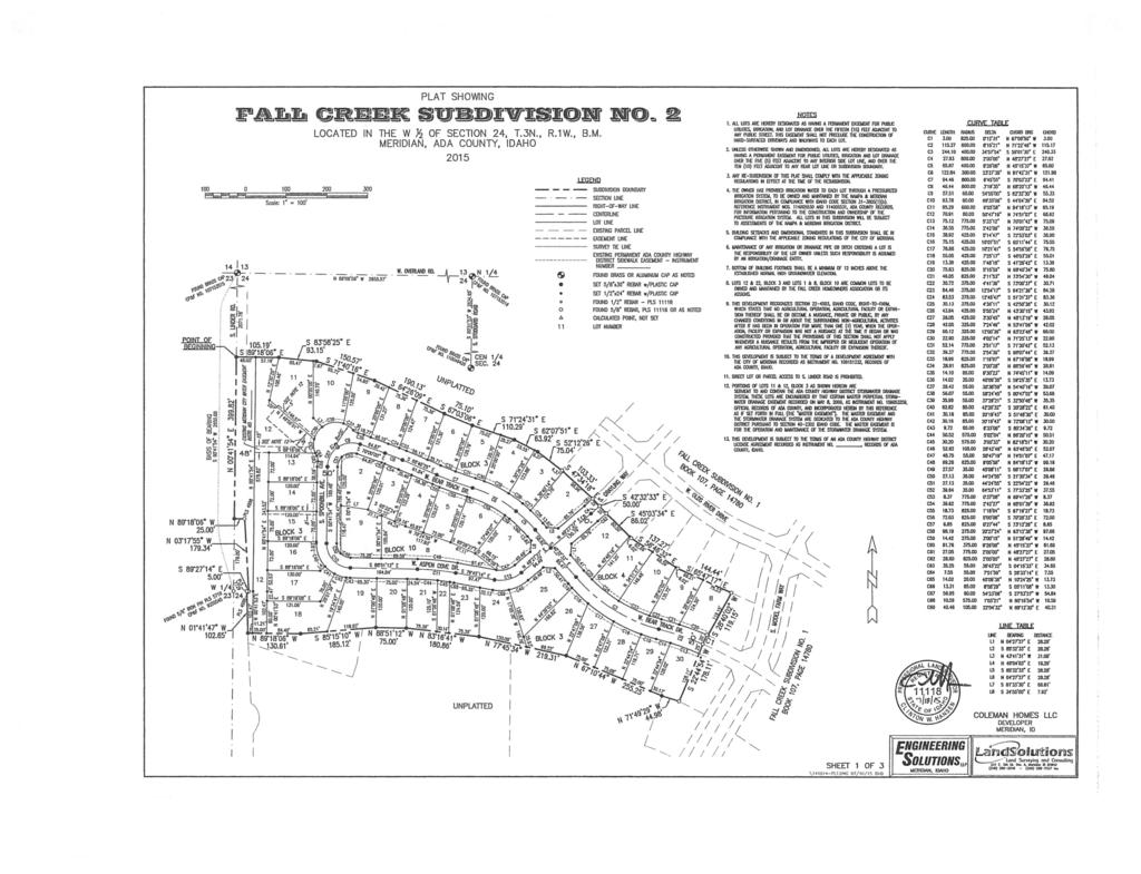
6 Development Services Department Project/File: Lead Agency: Site address: Fall Creek Subdivision (MPP ) This is a preliminary plat application to subdivision approximately 110 acres into 296 residential lots and 32 common lots. The site is located on the west side of Linder Road approximately ¼ mile south of Overland Road in Meridian, Idaho. City of Meridian S. Linder Road Commission Consent Agenda Hearing: March 6, 2013 Applicant: Thomas M. Coleman Coleman Homes, LLC 1859 S. Topaz Way, Ste. 200 Meridian, ID Representative: Becky McKay Engineering Solutions, LLP 1029 N. Rosario Street, Ste. 100 Meridian, ID Staff Contact: Jarom Wagoner Phone: jwagoner@achdidaho.org Tech Review: February 19, 2013 A. Findings of Fact 1. Description of Application: The applicant is proposing to subdivide approximately 110 acres into 296 residential lots and 32 common lots. 2. Description of Adjacent Surrounding Area: Direction Land Use Zoning North Rural Urban Transition Zone RUT South Estate Residential Zone R1 East Medium low-density Residential District R-4 West Medium low-density Residential District R-4 3. Site History: ACHD Commission previously reviewed this site as Bear Creek West Subdivision (MPP ) in January of That request was to divide approximately 115 acres into 321 residential lots and 34 common lots. The requirements of this staff report differ from those of the prior action due to the length of time that has passed and to comply with District Policy 7200, which was updated in January of Fall Creek
7 4. Impact Fees: There will be an impact fee that is assessed and due prior to issuance of any building permits. The assessed impact fee will be based on the impact fee ordinance that is in effect at that time. 5. Capital Improvements Plan (CIP)/Five Year Work Plan (FYWP): There are currently no roadways, bridges or intersections in the general vicinity of the project that are currently in the Five Year Work Program. Linder Road is listed in the Capital Improvements Plan to be widened to 5-lanes from Victory Road to Overland Road between 2027 and B. Traffic Findings for Consideration 1. Trip Generation: This development is estimated to generate 2,833 additional vehicle trips per day (none existing); 299 additional vehicle trips per hour in the PM peak hour (none existing), based on the traffic impact study. 2. Traffic Impact Study Engineering Solutions prepared a traffic impact study for the proposed Fall Creek Subdivision. Below is an executive summary of the findings as presented by Engineering Solutions. The following executive summary is not the opinion of ACHD staff. ACHD has reviewed the submitted traffic impact study for consistency with ACHD policies and practices, and may have additional requirements beyond what is noted in the summary. ACHD Staff comments on the submitted traffic impact study can be found below under staff comments. Executive Summary The proposed Fall Creek Subdivision is a residential development located south of Overland Road and between Stoddard Road and Linder Road in Meridian, Idaho. This project is planned to include 296 single-family homes on acres. A development application was submitted in 2005 as Bear Creek West Subdivision. The original preliminary plat expired and the project was never constructed. The new site plan has a revised number of lots, and this traffic analysis is an update of that original analysis. The following are the principal conclusions of the traffic analysis for the Fall Creek development. 1) The proposed development is projected to generate an average daily traffic (ADT) volume of 2,833 vehicles, of which the a.m. and p.m. peak hour traffic is 222 and 299 vehicles per hour respectively. 2) As a result of the site build-out, traffic on the area roadways is expected to increase in the vicinity. Traffic on Overland Road may increase by 1,332 trips per day west of Linder Road and 1,077 trips per day east of Stoddard Road. Traffic on Linder Road may increase by 1,700 trips per day south of Overland Road. Traffic on Stoddard Road may increase by 708 trips per day south of Overland Road. 3) The intersection of Overland Road and Linder Road is currently a two-way stop controlled intersection. The stop control is on the Linder Road approach. Overland Road provides four travel lanes plus an added left turn lane. Linder Road is a two lane roadway that adds a left turn lane at the Overland Road intersection. This intersection currently operates at LOS B and A during the a.m. and p.m. peak hours, respectively. For the Year 2017 background condition (i.e., regional growth but without the site-generated traffic), the intersection is forecast to operate at LOS B during the a.m. and p.m. peak hours. No improvements are needed to accommodate the existing or background traffic volumes. 2 Fall Creek
8 For the Year 2017 build out condition (i.e., background regional growth plus the site-generated traffic), the intersection is forecast to operate at LOS B during the a.m. and p.m. peak hours. No additional improvements are needed to accommodate the build out traffic volumes. 4) The intersection of Overland Road and Stoddard Road is currently a signal controlled intersection. Overland Road provides four travel lanes plus an added left turn lane. Stoddard Road is a two lane roadway that adds a left turn lane at the Overland Road intersection. This intersection currently operates at LOS C during the a.m. and p.m. peak hours. For the Year 2017 background condition (i.e., regional growth but without the site-generate traffic), the intersection is forecast to operate at LOS C during the a.m. and p.m. peak hours. No improvements are needed to accommodate the existing or background traffic volumes. For the Year 2017 build out condition (i.e., background regional growth plus the site-generated traffic), the intersection is forecast to operate at LOS C during the a.m. and p.m. peak hours. No additional improvements are needed to accommodate the build out traffic volumes. 5) The site plan shows that Kodiak Drive is a planned collector roadway and will create a new site access on Linder Road. The intersection does not exist but will be created with the Fall Creek Subdivision. The west approach to the intersection was constructed by the Southridge project. Under build out conditions the intersection will operate at LOS B and A during the a.m. and p.m. peak hours, respectively. This intersection meets current ACHD policy for an added southbound left turn lane (see Appendix). This intersection does not meet current ACHD policy for an added northbound right turn lane (see Appendix). 6) The site plan shows that Kodiak Drive is a planned collector roadway and will create a new site access on Stoddard Road. The east approach to this intersection was created with the adjacent Bear Creek Subdivision. The LDS church has installed a short portion of the west leg of Kodiak Drive collector. (I believe they installed one-half plus 12 feet.) The Fall Creek Subdivision will add the fourth (eastbound) approach. Under build-out conditions, the intersection will operate at LOS A and B during the a.m. and p.m. peak hours, respectively. This intersection does not meet current ACHD policy for an added northbound left turn lane (see Appendix). This intersection does not meet current ACHD policy for an added southbound right turn lane (see Appendix). 7) The forecast peak hour build-out volumes (Year 2017) for Overland Road, Linder Road and Stoddard Road are all lower than the planning development thresholds in the vicinity of the project. None of the study area roadways require further expansion to accommodate the site generated traffic volumes. 8) Kodiak Drive is planned as a residential collector. Traffic volumes exceed 1,000 ADT but there is no front-on housing. None of the internal residential streets exceed 1,000 ADT in areas with front-on housing. 9) This project is expected to generate approximately $902,000 in impact fee revenues to the Ada County Highway District under the requirements of Ordinance ) The conclusions of this report are consistent with the recent traffic study submitted for the adjacent Wal-Mart site. Following are the transportation-related improvements needed to accommodate the traffic volumes generated by the Fall Creek development: Construct a southbound left turn lane for Linder Road at the new Kodiak Drive intersection. No other traffic-related improvements have been identified with this analysis. 3 Fall Creek
9 Staff Comments/Recommendations: ACHD has completed a review of the required traffic impact study and has found it to be in compliance with ACHD Policy and standards. As such staff agrees with the study and the recommendation to construct a southbound left-turn lane on Linder Road at the new Kodiak Drive intersection. 3. Condition of Area Roadways Traffic Count is based on Vehicles per hour (VPH) Roadway Linder Road Stoddard Road Frontage 2,600 feet Functional Classification PM Peak Hour Traffic Count Minor Arterial feet Collector 114 PM Peak Hour Level of Service Better than D Better than D Existing Plus Project Future Level of Service Better than D Better than D * Acceptable level of service for a two-lane minor arterial is D (550 VPH). * Acceptable level of service for a three-lane collector is D (530 VPH). 4. Average Daily Traffic Count (VDT) Average daily traffic counts are based on ACHD s most current traffic counts. The average daily traffic count for Linder Road south of Overland Road was 1,900 on December 3, The average daily traffic count for Stoddard Road south of Overland Road was 2,600 on December 3, C. Findings for Consideration 1. South Meridian Transportation Plan The South Meridian Transportation Plan (SMTP) is a long range planning tool developed to plan for future growth in the South Meridian Area by identifying future roadway, intersection, and corridor needs. The SMTP provides a framework for future roadway improvements based on the land use designations. The plan also investigates alternative transportation solutions including pedestrian and bicycle pathways. The plan was created in collaboration the City of Meridian and was adopted by the ACHD Commission in May of Staff Comments/Recommendations: The South Meridian Transportation Plan identifies a midmile collector roadway to be constructed through the site, providing a connection from Linder Road to Stoddard Road. The applicant is proposing to construct this roadway, aligning with American Fork Drive to the west and Kodiak Drive to the east. 2. Linder Road a. Existing Conditions: Linder Road is improved with 2-travel lanes, and no curb, gutter or sidewalk abutting the site. There is 72 feet of right-of-way for Linder Road (25 feet from centerline). b. Policy: Arterial Roadway Policy: District Policy states that the developer is responsible for improving all street frontages adjacent to the site regardless of whether or not access is taken to all of the adjacent streets. Master Street Map and Typology Policy: District Policy states that the design of improvements for arterials shall be in accordance with District standards, including the Master 4 Fall Creek
10 Street Map and Livable Streets Design Guide. The developer or engineer should contact the District before starting any design. Street Section and Right-of-Way Width Policy: District Policies & state that the standard 5-lane street section shall be 72 feet (back-of-curb to back-of-curb) within 96 feet of right-of-way. This width typically accommodates two travel lanes in each direction, a continuous center left-turn lane, and bike lanes on a minor arterial and a safety shoulder on a principal arterial. Sidewalk Policy: District Policy requires a concrete sidewalk at least 5-feet wide to be constructed on both sides of all arterial streets. A parkway strip at least 6-feet wide between the back-of-curb and street edge of the sidewalk is required to provide increased safety and protection of pedestrians. Consult the District s planter width policy if trees are to be placed within the parkway strip. Sidewalks constructed next to the back-of-curb shall be a minimum of 7 feet wide. Detached sidewalks are encouraged and should be parallel to the adjacent roadway. Meandering sidewalks are discouraged. A permanent right-of-way easement shall be provided if public sidewalks are placed outside of the dedicated right-of-way. The easement shall encompass the entire area between the rightof-way line and 2 feet behind the back edge of the sidewalk. Sidewalks shall either be located wholly within the public right-of-way or wholly within an easement. ACHD Master Street Map: ACHD Policy Section requires the Master Street Map (MSM) guide the right-of-way acquisition, arterial street requirements, and specific roadway features required through development. This segment of Linder Road is designated in the MSM as a Residential Arterial with 5-lanes and on-street bike lanes, a 70-foot street section within 96 feet of right-of-way. c. Applicant Proposal: The applicant is proposing to dedicate 48 feet of right-of-way from the centerline of Linder Road, abutting the site. The applicant is proposing to construct a 5-foot wide meandering sidewalk along Linder Road, abutting the site. d. Staff Comments/Recommendations: The applicant s proposal meets District Policy and should be approved, as proposed. The applicant should be required to construct the sidewalk a minimum of 42 feet from the centerline of Linder Road (measured to near edge of sidewalk). District Policy states that detached sidewalks should be parallel to the adjacent roadway and that meandering sidewalks are discouraged. The applicant should provide the District with a permanent right-of-way easement for any portion of the sidewalk located outside of the right-of-way. 3. Stoddard Road a. Existing Conditions: Stoddard Road is improved with 3-travel lanes, and no curb, gutter, or sidewalk abutting the site. There is 58 feet of right-of-way for Stoddard Road (29 feet from centerline). b. Policy: Collector Street Policy: District Policy states that the developer is responsible for improving all collector frontages adjacent to the site or internal to the development as required below, regardless of whether access is taken to all of the adjacent streets. Master Street Map and Typologies Policy: District Policy states that if the collector street is designated with a typology on the Master Street Map, that typology shall be considered for the required street improvements. If there is no typology listed in the Master Street Map, then standard street sections shall serve as the default. 5 Fall Creek
11 Street Section and Right-of-Way Policy: District Policy states that the standard right-of-way width for collector streets shall typically be 50 to 70 feet, depending on the location and width of the sidewalk and the location and use of the roadway. The right-of-way width may be reduced, with District approval, if the sidewalk is located within an easement; in which case the District will require a minimum right-of-way width that extends 2 feet behind the back-of-curb on each side. The standard street section shall be 46 feet (back-of-curb to back-of-curb). This width typically accommodates a single travel lane in each direction, a continuous center left-turn lane, and bike lanes. Sidewalk Policy: District Policy requires a concrete sidewalk at least 5 feet wide to be constructed on both sides of all collector streets. A parkway strip at least 6 feet wide between the back-of-curb and street edge of the sidewalk is required to provide increased safety and protection of pedestrians. Consult the District s planter width policy if trees are to be placed within the parkway strip. Sidewalks constructed next to the back-of-curb shall be a minimum of 7 feet wide. Detached sidewalks are encouraged and should be parallel to the adjacent roadway. Meandering sidewalks are discouraged. A permanent right-of-way easement shall be provided if public sidewalks are placed outside of the dedicated right-of-way. The easement shall encompass the entire area between the rightof-way line and 2 feet behind the back edge of the sidewalk. Sidewalks shall either be located wholly within the public right-of-way or wholly within an easement. ACHD Master Street Map: ACHD Policy Section requires the Master Street Map (MSM) guide the right-of-way acquisition, collector street requirements, and specific roadway features required through development. This segment of Stoddard Road is designated in the MSM as a Residential Collector with 2 lanes and on-street bike lanes, a 47-foot street section within 69 feet of right-of-way. c. Applicant Proposal: The applicant is proposing to construct Stoddard Road as one-half of a 46-foot street section with vertical curb, gutter, and 5-foot wide detached concrete sidewalk within 35 feet of right-of-way. d. Staff Comments/Recommendations: The applicant s proposal meets District Policy and should be approved, as proposed. The applicant should provide the District with a permanent right-of-way easement for any portion of the sidewalk located outside of the right-of-way. 4. Kodiak Drive a. Existing Conditions: The site has no internal collector streets. b. Policy: Collector Street Policy: District Policy states that the developer is responsible for improving all collector frontages adjacent to the site or internal to the development as required below, regardless of whether access is taken to all of the adjacent streets. Master Street Map and Typologies Policy: District Policy states that if the collector street is designated with a typology on the Master Street Map, that typology shall be considered for the required street improvements. If there is no typology listed in the Master Street Map, then standard street sections shall serve as the default. Street Section and Right-of-Way Policy: District Policy states that the standard right-of-way width for collector streets shall typically be 50 to 70 feet, depending on the location and width of the sidewalk and the location and use of the roadway. The right-of-way width may be reduced, with District approval, if the sidewalk is located within an easement; in 6 Fall Creek
12 which case the District will require a minimum right-of-way width that extends 2 feet behind the back-of-curb on each side. The standard street section shall be 46 feet (back-of-curb to back-of-curb). This width typically accommodates a single travel lane in each direction, a continuous center left-turn lane, and bike lanes. Residential Collector Policy: District Policy states that the standard street section for a collector in a residential area shall be 36 feet (back-of-curb to back-of-curb). The District will consider a 33-foot or 29-foot street section with written fire department approval and taking into consideration the needs of the adjacent land use, the projected volumes, the need for bicycle lanes, and on-street parking. Sidewalk Policy: District Policy requires a concrete sidewalk at least 5 feet wide to be constructed on both sides of all collector streets. A parkway strip at least 6 feet wide between the back-of-curb and street edge of the sidewalk is required to provide increased safety and protection of pedestrians. Consult the District s planter width policy if trees are to be placed within the parkway strip. Sidewalks constructed next to the back-of-curb shall be a minimum of 7 feet wide. Detached sidewalks are encouraged and should be parallel to the adjacent roadway. Meandering sidewalks are discouraged. A permanent right-of-way easement shall be provided if public sidewalks are placed outside of the dedicated right-of-way. The easement shall encompass the entire area between the rightof-way line and 2 feet behind the back edge of the sidewalk. Sidewalks shall either be located wholly within the public right-of-way or wholly within an easement. Landscape Medians Policy: District Policy states that landscape medians are permissible where adequate pavement width is provided on each side of the median to accommodate the travel lanes and where the following is provided: The median is platted as right-of-way owned by ACHD. The width of an island near an intersection is 12-feet maximum for a minimum distance of 150-feet. Beyond the 150-feet, the island may increase to a maximum width of 30-feet. At an intersection that is signalized or is to be signalized in the future, the median width shall be reduced to accommodate the necessary turn lane storage and tapers. The Developer or Homeowners Association shall apply for a license agreement if landscaping is to be placed within these medians. The license agreement shall contain the District s requirements of the developer including, but not limited to, a hold harmless clause; requirements for maintenance by the developer; liability insurance requirements; and restrictions. Vertical curbs are required around the perimeter of any raised median. Gutters shall slope away from the curb to prevent ponding. ACHD Master Street Map: ACHD Policy Section requires the Master Street Map (MSM) guide the right-of-way acquisition, collector street requirements, and specific roadway features required through development. A new collector roadway was identified on the MSM with the street typology of Residential Collector. The new collector roadway should align with Kodiak Road on the east side of Stoddard Road and continue through the property stubbing to the west. The Residential Collector typology as depicted in the Livable Street Design Guide recommends a 2-lane roadway, a 36-foot street section within 50 feet of right-of-way. c. Applicant Proposal: The applicant is proposing to construct Kodiak Drive as a 36-foot wide residential collector with vertical curb, gutter, 8-foot wide planter strip, 5-foot wide detached sidewalk, and no front-on housing. 7 Fall Creek
13 The applicant is proposing to construct a 12-foot wide landscape median beginning at the intersection of Kodiak Drive and Linder Road and running east for approximately 70 feet. d. Staff Comments/Recommendations: The applicant s proposal to construct Kodiak Drive as a 36-foot wide residential collector roadway meets District Policy and should be approved, as proposed. The applicant should be required to construct the entire street section of Kodiak Drive from Linder Road to Stoddard Road, including the segment that borders the Meridian School District site to the north, as proposed. The right-of-way for Kodiak Drive must extend to the property line of the Meridian School District site to the north. The applicant should be required to plat the landscape median as right-of-way owned by ACHD. The landscape median will be restricted to a maximum width of 12 feet as required by District Policy The applicant should apply for a licensing agreement with the District for any landscaping located within the median. 5. Internal Local Streets a. Existing Conditions: The site has no internal streets. b. Policy: Local Roadway Policy: District Policy states that the developer is responsible for improving all local street frontages adjacent to the site regardless of whether or not access is taken to all of the adjacent streets. Street Section and Right-of-Way Policy: District Policy states that right-of-way widths for all local streets shall generally not be less than 50-feet wide and that the standard street section shall be 36-feet (back-of-curb to back-of-curb). The District will consider the utilization of a street width less than 36-feet with written fire department approval. Sidewalk Policy: District Policy states that a five-foot wide concrete sidewalk is required on both sides of all local streets, except those in rural developments with net densities of one dwelling unit per 1.0 acre or less, or in hillside conditions where there is no direct lot frontage, in which case a sidewalk shall be constructed along one side of the street. Some local jurisdictions may require wider sidewalks. The sidewalk may be placed next to the back-of-curb. Where feasible, a parkway strip at least 8 feet wide between the back-of-curb and the street edge of the sidewalk is recommended to provide increased safety and protection of pedestrians and to allow for the planting of trees in accordance with the District s Tree Planting Policy. If no trees are to be planted in the parkway strip, the applicant may submit a request to the District, with justification, to reduce the width of the parkway strip. Detached sidewalks are encouraged and should be parallel to the adjacent roadway. Meandering sidewalks are discouraged. A permanent right-of-way easement shall be provided if public sidewalks are placed outside of the dedicated right-of-way. The easement shall encompass the entire area between the rightof-way line and 2 feet behind the back edge of the sidewalk. Sidewalks shall either be located wholly within the public right-of-way or wholly within an easement.). Cul-de-sac Streets Policy: District Policy requires cul-de-sacs to be constructed to provide a minimum turning radius of 45 feet; in rural areas or for temporary cul-de-sacs the emergency service providers may require a greater radius. Landscape and parking islands may be constructed in turnarounds if a minimum 29-foot street section is constructed around the island. The pavement width shall be sufficient to allow the turning around of a standard AASHTO SU design vehicle without backing. The developer shall provide written approval from the appropriate fire department for this design element. 8 Fall Creek
14 The District will consider alternatives to the standard cul-de-sac turnaround on a case-by-case basis. This will be based on turning area, drainage, maintenance considerations and the written approval of the agency providing emergency fire service for the area where the development is located. Landscape Medians Policy: District Policy states that landscape medians are permissible where adequate pavement width is provided on each side of the median to accommodate the travel lanes and where the following is provided: The median is platted as right-of-way owned by ACHD. The width of an island near an intersection is 12 feet maximum for a minimum distance of 150 feet. Beyond the 150 feet, the island may increase to a maximum width of 30 feet. At an intersection that is signalized or is to be signalized in the future, the median width shall be reduced to accommodate the necessary turn lane storage and tapers. The Developer or Homeowners Association shall apply for a license agreement if landscaping is to be placed within these medians. The license agreement shall contain the District s requirements of the developer including, but not limited to, a hold harmless clause; requirements for maintenance by the developer; liability insurance requirements; and restrictions. Vertical curbs are required around the perimeter of any raised median. Gutters shall slope away from the curb to prevent ponding. c. Applicant s Proposal: The applicant is proposing to construct the internal local streets as 36- foot street sections with rolled curb, gutter, 8-foot wide planter strip, and 5-foot wide detached concrete sidewalks within 50 feet of right-of-way. The applicant is proposing to construct 3 cul-de-sac turnarounds within the site with a turning radius of 50 feet. The applicant is proposing to construct 3 landscape medians. They are located as follows: 12-foot wide landscape median along Sockeye Way from its intersection with Kodiak Drive and running north for approximately 100 feet. 12-foot wide landscape median along Brook Trout Avenue from its intersection with Kodiak Drive and running south for approximately 100 feet. 12-foot wide landscape median along Model Farm Way from its intersection with Kodiak Drive and running west for approximately 60 feet. d. Staff Comments/Recommendations: The applicant s proposal meets District Local Streets Policy and should be approved, as proposed. The applicant should provide a permanent right-of-way easement for the detached sidewalks located outside of the right-of-way. The applicant s proposal meets District Cul-de-sac Streets Policy and should be approved, as proposed. The applicant should be required to provide a minimum turning radius of 45 feet. The applicant should be required to plat the medians as right-of-way owned by ACHD. The landscape medians will be restricted to a maximum width of 12 feet as required by District Policy The applicant should apply for a licensing agreement with the District for any landscaping located within the medians. 6. Roadway Offsets a. Existing Conditions: There are no existing roadway offsets internal to the development b. Policy: Collector Street Intersection Spacing on Minor Arterials: District Policy states that the minimum allowable offset for an unsignalized collector street intersecting a principal arterial shall be 1,320 feet as measured from all other existing roadways as identified in Table 1a. 9 Fall Creek
15 Local Offset Policy: District Policy , requires local roadways to align or offset a minimum of 330 feet from a collector roadway (measured centerline to centerline). District Policy , requires local roadways to align or provide a minimum offset of 125 feet from any other street (measured centerline to centerline). c. Applicant s Proposal: The applicant is proposing to construct Kodiak Drive, a collector roadway, to intersect Linder Road in alignment with American Fork Drive approximately ¼ mile south of Overland Road, and to continue thru the development intersecting with Stoddard Road in alignment with Kodiak Drive to the east approximately ½ mile south of Overland Road. The applicant is proposing all of the internal local streets to offset a minimum of 125-feet. d. Staff Comments/Recommendations: The applicant s proposal meets District Collector and Local Roadway Offset Policies, and should be approved as proposed. 7. Stub Streets a. Existing Conditions: There is one stub street (Kodiak Drive) to the site. The stub street is located on the west side of Stoddard Road approximately ½ mile south of Overland Road. b. Policy: Stub Street Policy: District Policy states that stub streets will be required to provide circulation or to provide access to adjoining properties. Stub streets will conform with the requirements described in Section , except a temporary cul-de-sac will not be required if the stub street has a length no greater than 150 feet. A sign shall be installed at the terminus of the stub street stating that, "THIS ROAD WILL BE EXTENDED IN THE FUTURE. In addition, stub streets must meet the following conditions: A stub street shall be designed to slope towards the nearest street intersection within the proposed development and drain surface water towards that intersection; unless an alternative storm drain system is approved by the District. The District may require appropriate covenants guaranteeing that the stub street will remain free of obstructions. Temporary Dead End Streets Policy: District Policy requires that the design and construction for cul-de-sac streets shall apply to temporary dead end streets. The temporary cul-de-sac shall be paved and shall be the dimensional requirements of a standard cul-de-sac. The developer shall grant a temporary turnaround easement to the District for those portions of the cul-de-sac which extend beyond the dedicated street right-of-way. In the instance where a temporary easement extends onto a buildable lot, the entire lot shall be encumbered by the easement and identified on the plat as a non-buildable lot until the street is extended. c. Applicant Proposal: The applicant is proposing to continue Kodiak Drive into the site as a residential collector connecting with Linder Road to the west. The applicant is proposing to construct one new stub street (Sockeye Way) internal to the development located approximately 850 feet east of Linder Road and 1,650 feet south of Overland Road (between Lot 26 Block 1 and Lot 15 Block 4). d. Staff Comments/Recommendations: The applicant s proposal meets District Stub Streets Policy and should be approved, as proposed. The applicant should be required to install a sign at the terminus of the stub street stating that, THIS ROAD WILL BE EXTENDED IN THE FUTURE. 10 Fall Creek
16 8. Tree Planters Tree Planter Policy: Tree Planter Policy: The District s Tree Planter Policy prohibits all trees in planters less than 8-feet in width without the installation of root barriers. Class II trees may be allowed in planters with a minimum width of 8-feet, and Class I and Class III trees may be allowed in planters with a minimum width of 10-feet. 9. Landscaping Landscaping Policy: A license agreement is required for all landscaping proposed within ACHD right-of-way or easement areas. Trees shall be located no closer than 10-feet from all public storm drain facilities. Landscaping should be designed to eliminate site obstructions in the vision triangle at intersections. District Policy requires a 40-foot vision triangle and a 3-foot height restriction on all landscaping located at an uncontrolled intersection and a 50-foot offset from stop signs. Landscape plans are required with the submittal of civil plans and must meet all District requirements prior to signature of the final plat and/or approval of the civil plans. 10. Other Access Linder Road is classified as a minor arterial roadway; Stoddard Road is classified as a collector roadway. Direct lot access is prohibited to these roadways and should be noted on the final plat. D. Site Specific Conditions of Approval 1. Dedicate 48 feet of right-of-way from the centerline of Linder Road, abutting the site. The right-ofway purchase and sale agreement and deed must be completed and signed by the applicant prior to issuance of a building permit (or other required permits). Allow up to 30 business days to process the right-of-way dedication after receipt of all requested material. The District will purchase the right-of-way which is in addition to the existing right-of-way from available Corridor Preservation Funds. 2. Construct a southbound left-turn lane on Linder Road at the new Kodiak Drive intersection. Coordinate the design and location of the left-turn lane with District Traffic Services and Development Review staff. 3. Construct a 5-foot wide detached concrete sidewalk located a minimum of 42 feet from the centerline of Linder Road, abutting the site. Provide a permanent right-of-way easement for any portion of the sidewalk located outside of the right-of-way. 4. Dedicate 35 feet of right-of-way from the centerline of Stoddard Road, abutting the site. 5. Construct Stoddard Road as one-half of a 46-foot street section with vertical curb, gutter, and 5- foot wide detached concrete sidewalk abutting the site, as proposed. Provide the District with a permanent right-of-way easement for any portion of the sidewalk located outside of the right-ofway. 6. Construct Kodiak Drive as a 36-foot residential collector with vertical curb, gutter, 8-foot wide planter strips, and 5-foot wide detached sidewalks within 50 feet of right-of-way, as proposed. Kodiak Drive shall intersect Linder Road in alignment with American Fork Drive approximately ¼ mile south of Overland Road, and continue east thru the development intersecting with Stoddard Road in alignment with Kodiak Drive approximately ½ mile south of Overland Road. Provide the District with a sidewalk easement for any segment of the sidewalk located outside of the right-ofway. Parking and front-on housing are prohibited on Kodiak Drive. The right-of-way for Kodiak Drive shall extend to the property line of the Meridian School District site to the north. 7. Construct the internal local streets as 36-foot street sections with rolled curb, gutter, 8-foot wide planter strip, and 5-foot wide detached concrete sidewalks within 50 feet of right-of-way. Provide the District with a permanent right-of-way easement for the detached sidewalks. 11 Fall Creek
17 8. Construct 3 cul-de-sacs turnarounds with a minimum turning radius of 50 feet, as proposed. 9. All of the landscape medians are restricted to a maximum width of 12 feet and shall be dedicate right-of-way owned by ACHD. The applicant shall d apply for a licensing agreement with the District for any landscaping located within the medians. 10. Construct one stub street to the north, Sockeye Way, located approximately 850 feet east of Linder Road and 1,650 feet south of Overland Road (between Lot 26 Block 1 and Lot 15 Block 4), as proposed. Install a sign at the terminus of the roadway stating, THIS ROAD WILL BE EXTENDED IN THE FUTURE. 11. Direct lot access is prohibited to Linder Road, Stoddard Road, and Kodiak Drive. This access restriction shall be noted on the final plat. 12. Payment of impacts fees are due prior to issuance of a building permit. 13. Comply with all Standard Conditions of Approval. E. Standard Conditions of Approval 1. Any existing irrigation facilities shall be relocated outside of the ACHD right-of-way. 2. Private sewer or water systems are prohibited from being located within the ACHD right-ofway. 3. In accordance with District Policy, , the applicant may be required to update any existing non-compliant pedestrian improvements abutting the site to meet current Americans with Disabilities Act (ADA) requirements. The applicant s engineer should provide documentation of ADA compliance to District Development Review staff for review. 4. Replace any existing damaged curb, gutter and sidewalk and any that may be damaged during the construction of the proposed development. Contact Construction Services at (with file number) for details. 5. A license agreement and compliance with the District s Tree Planter policy is required for all landscaping proposed within ACHD right-of-way or easement areas. 6. All utility relocation costs associated with improving street frontages abutting the site shall be borne by the developer. 7. It is the responsibility of the applicant to verify all existing utilities within the right-of-way. The applicant at no cost to ACHD shall repair existing utilities damaged by the applicant. The applicant shall be required to call DIGLINE ( ) at least two full business days prior to breaking ground within ACHD right-of-way. The applicant shall contact ACHD Traffic Operations in the event any ACHD conduits (spare or filled) are compromised during any phase of construction. 8. Utility street cuts in pavement less than five years old are not allowed unless approved in writing by the District. Contact the District s Utility Coordinator at (with file numbers) for details. 9. All design and construction shall be in accordance with the ACHD Policy Manual, ISPWC Standards and approved supplements, Construction Services procedures and all applicable ACHD Standards unless specifically waived herein. An engineer registered in the State of Idaho shall prepare and certify all improvement plans. 10. Construction, use and property development shall be in conformance with all applicable requirements of ACHD prior to District approval for occupancy. 11. No change in the terms and conditions of this approval shall be valid unless they are in writing and signed by the applicant or the applicant s authorized representative and an 12 Fall Creek
18 authorized representative of ACHD. The burden shall be upon the applicant to obtain written confirmation of any change from ACHD. 12. If the site plan or use should change in the future, ACHD Planning Review will review the site plan and may require additional improvements to the transportation system at that time. Any change in the planned use of the property which is the subject of this application, shall require the applicant to comply with ACHD Policy and Standard Conditions of Approval in place at that time unless a waiver/variance of the requirements or other legal relief is granted by the ACHD Commission. F. Conclusions of Law 1. The proposed site plan is approved, if all of the Site Specific and Standard Conditions of Approval are satisfied. 2. ACHD requirements are intended to assure that the proposed use/development will not place an undue burden on the existing vehicular transportation system within the vicinity impacted by the proposed development. G. Attachments 1. Vicinity Map 2. Site Plan 3. Utility Coordinating Council 4. Development Process Checklist 5. Request for Reconsideration Guidelines 13 Fall Creek

19 Vicinity Map 14 Fall Creek

20 Site Plan 15 Fall Creek
21 Ada County Utility Coordinating Council Developer/Local Improvement District Right of Way Improvements Guideline Request Purpose: To develop the necessary avenue for proper notification to utilities of local highway and road improvements, to help the utilities in budgeting and to clarify the already existing process. 1) Notification: Within five (5) working days upon notification of required right of way improvements by Highway entities, developers shall provide written notification to the affected utility owners and the Ada County Utility Coordinating Council (UCC). Notification shall include but not be limited to, project limits, scope of roadway improvements/project, anticipated construction dates, and any portions critical to the right of way improvements and coordination of utilities. 2) Plan Review: The developer shall provide the highway entities and all utility owners with preliminary project plans and schedule a plan review conference. Depending on the scale of utility improvements, a plan review conference may not be necessary, as determined by the utility owners. Conference notification shall also be sent to the UCC. During the review meeting the developer shall notify utilities of the status of right of way/easement acquisition necessary for their project. At the plan review conference each company shall have the right to appeal, adjust and/or negotiate with the developer on its own behalf. Each utility shall provide the developer with a letter of review indicating the costs and time required for relocation of its facilities. Said letter of review is to be provided within thirty calendar days after the date of the plan review conference. 3) Revisions: The developer is responsible to provide utilities with any revisions to preliminary plans. Utilities may request an updated plan review meeting if revisions are made in the preliminary plans which affect the utility relocation requirements. Utilities shall have thirty days after receiving the revisions to review and comment thereon. 4) Final Notification: The developer will provide highway entities, utility owners and the UCC with final notification of its intent to proceed with right of way improvements and include the anticipated date work will commence. This notification shall indicate that the work to be performed shall be pursuant to final approved plans by the highway entity. The developer shall schedule a preconstruction meeting prior to right of way improvements. Utility relocation activity shall be completed within the times established during the preconstruction meeting, unless otherwise agreed upon. Notification to the Ada County UCC can be sent to: 50 S. Cole Rd. Boise 83707, or Visit iducc.com for notification information. 16 Fall Creek
22 Development Process Checklist Items Completed to Date: Submit a development application to a City or to Ada County The City or the County will transmit the development application to ACHD The ACHD Planning Review Section will receive the development application to review The Planning Review Section will do one of the following: Send a No Review letter to the applicant stating that there are no site specific conditions of approval at this time. Write a Staff Level report analyzing the impacts of the development on the transportation system and evaluating the proposal for its conformance to District Policy. Write a Commission Level report analyzing the impacts of the development on the transportation system and evaluating the proposal for its conformance to District Policy. Items to be completed by Applicant: For ALL development applications, including those receiving a No Review letter: The applicant should submit one set of engineered plans directly to ACHD for review by the Development Review Section for plan review and assessment of impact fees. (Note: if there are no site improvements required by ACHD, then architectural plans may be submitted for purposes of impact fee assessment.) The applicant is required to get a permit from Construction Services (ACHD) for ANY work in the right-ofway, including, but not limited to, driveway approaches, street improvements and utility cuts. Pay Impact Fees prior to issuance of building permit. Impact fees cannot be paid prior to plan review approval. DID YOU REMEMBER: Construction (Non-Subdivisions) Driveway or Property Approach(s) Submit a Driveway Approach Request form to ACHD Construction (for approval by Development Services & Traffic Services). There is a one week turnaround for this approval. Working in the ACHD Right-of-Way Four business days prior to starting work have a bonded contractor submit a Temporary Highway Use Permit Application to ACHD Construction Permits along with: a) Traffic Control Plan b) An Erosion & Sediment Control Narrative & Plat, done by a Certified Plan Designer, if trench is >50 or you are placing >600 sf of concrete or asphalt. Construction (Subdivisions) Sediment & Erosion Submittal At least one week prior to setting up a Pre-Construction Meeting an Erosion & Sediment Control Narrative & Plan, done by a Certified Plan Designer, must be turned into ACHD Construction to be reviewed and approved by the ACHD Stormwater Section. Idaho Power Company Vic Steelman at Idaho Power must have his IPCO approved set of subdivision utility plans prior to Pre-Con being scheduled. Final Approval from Development Services is required prior to scheduling a Pre-Con. 17 Fall Creek
23 Request for Reconsideration of Commission Action 1. Request for Reconsideration of Commission Action: A Commissioner, a member of ACHD staff or any other person objecting to any final action taken by the Commission may request reconsideration of that action, provided the request is not for a reconsideration of an action previously requested to be reconsidered, an action whose provisions have been partly and materially carried out, or an action that has created a contractual relationship with third parties. a. Only a Commission member who voted with the prevailing side can move for reconsideration, but the motion may be seconded by any Commissioner and is voted on by all Commissioners present. If a motion to reconsider is made and seconded it is subject to a motion to postpone to a certain time. b. The request must be in writing and delivered to the Secretary of the Highway District no later than 3:00 p.m. on the day prior to the Commission s next scheduled regular meeting following the meeting at which the action to be reconsidered was taken. Upon receipt of the request, the Secretary shall cause the same to be placed on the agenda for that next scheduled regular Commission meeting. c. The request for reconsideration must be supported by written documentation setting forth new facts and information not presented at the earlier meeting, or a changed situation that has developed since the taking of the earlier vote, or information establishing an error of fact or law in the earlier action. The request may also be supported by oral testimony at the meeting. d. If a motion to reconsider passes, the effect is the original matter is in the exact position it occupied the moment before it was voted on originally. It will normally be returned to ACHD staff for further review. The Commission may set the date of the meeting at which the matter is to be returned. The Commission shall only take action on the original matter at a meeting where the agenda notice so provides. e. At the meeting where the original matter is again on the agenda for Commission action, interested persons and ACHD staff may present such written and oral testimony as the President of the Commission determines to be appropriate, and the Commission may take any action the majority of the Commission deems advisable. f. If a motion to reconsider passes, the applicant may be charged a reasonable fee, to cover administrative costs, as established by the Commission. 18 Fall Creek
BPP / SUB
 Development Services Department Project/File: Lead Agency: Site address: Millwell Place Subdivision/ BPP15-0031/ SUB15-0064 This is a preliminary plat application to allow for the development of 68 building
Development Services Department
 Kent Goldthorpe, President Paul Woods, Vice President Rebecca W. Arnold, Commissioner Sara M. Baker, Commissioner Jim D. Hansen, Commissioner July 21, 2016 Development Services Department To: From: ACHD
 Development Services Department Project/File: Lead Agency: Site address: Aralar Park/SUB13-00048 This is a preliminary plat application to construct 55 buildable lots and 6 common lots on 12.67 acres.
BOI / DRH S. 13 th Street Mixed use office/retail development with residential dormitory
 Jim D. Hansen, President Sara M. Baker, Vice President Rebecca W. Arnold, Commissioner Kent Goldthorpe, Commissioner Paul Woods, Commissioner October 21, 2015 To: Rick Nesser ISS River Partners, LLC 8312
 Development Services Department Project/File: Lead Agency: Site address: Applicant: Memory Ranch / KPP15-0003 / 15-02-AN / 15-01-S The applicant is requesting annexation of approximately 10 acres, rezoning
ACHD Board of Commissioners Stacey Yarrington, Planner III Tandem Ridge/ EPP / PP-07-16/ RZ-12-16/ CPA-01-16/ A-07-16
 Development Services Department DATE: December 14, 2016 TO: FROM: SUBJECT: ACHD Board of Commissioners Stacey Yarrington, Planner III Tandem Ridge/ EPP16-0012/ PP-07-16/ Executive Summary: This is an annexation,
BPP / SUB /CAR /PUD
 Development Services Department Project/File: Lead Agency: Site address: Roe Street Townhomes/ BPP16-0023/ SUB16-00046/CAR16-00023/PUD16-00022 This is a rezone, preliminary plat, and planned unit development
Committed to Service
 Committed to Service Paul Woods, President Rebecca W. Arnold, Vice President Sara M. Baker, Commissioner Jim D. Hansen, Commissioner Kent Goldthorpe, Commissioner September 19, 2017 Development Services
Committed to Service
 Development Services Department Committed to Service January 19, 2016 TO: FROM: SUBJECT: ACHD Board of Commissioners Mindy Wallace, AICP Planner III Kirsten Subdivision/BPP15-0023 Executive Summary: The
Committed to Service. Development Services. February 21, ACHD Commission. Mindy Wallace, AICP
 Committed to Service Sara M. Baker, President Rebecca W. Arnold, Vice President Jim D. Hansen, Commissioner Kent Goldthorpe, Commissioner Paul Woods, Commissioner February 21, 2018 Development Services
Development Services Department
 Kent Goldthorpe, President Paul Woods, Vice President Rebecca W. Arnold, Commissioner Sara M. Baker, Commissioner Jim D. Hansen, Commissioner July 28, 2016 Development Services Department To: From: ACHD
Committed to Service
 Committed to Service Kent Goldthorpe, President Paul Woods, Vice President Rebecca W. Arnold, Commissioner Sara M. Baker, Commissioner Jim D. Hansen, Commissioner May 24, 2017 Development Services TO:
Committed to Service
 Committed to Service Sara M. Baker, President Rebecca W. Arnold, Vice President Jim D. Hansen, Commissioner Kent Goldthorpe, Commissioner Paul Woods, Commissioner February 21, 2018 Development Services
Committed to Service
 Development Services Department Committed to Service June 30, 2014 TO: FROM: SUBJECT: ACHD Board of Commissioners Christy Little Planning Review Supervisor Victory Middle School/MCUP-14-003 DATE: July
2. Caven Ridge Estates Subdivision No. 1 adds 0.54 centerline miles to the ACHD roadway system.
 Kent Goldthorpe, President Paul Woods, Vice President Rebecca W. Arnold, Commissioner Sara M. Baker, Commissioner Jim D. Hansen, Commissioner October 12, 2016 Development Services Department To: From:
Committed to Service
 Committed to Service Paul Woods, President Rebecca W. Arnold, Vice President Sara M. Baker, Commissioner Jim D. Hansen, Commissioner Kent Goldthorpe, Commissioner January 16, 2018 Development Services
Roadway Classification Design Standards and Policies. Pueblo, Colorado November, 2004
 Roadway Classification Design Standards and Policies Pueblo, Colorado November, 2004 Table of Contents Page Chapter 1. General Provisions 1.1 Jurisdiction 3 1.2 Purpose and Intent 3 1.3 Modification 3
Subdivision Staff Report
 Subdivision Staff Report Subdivision Name Plano Road Subdivision File Number SUB07-00065 Approval Preliminary Plat Lead Agency Boise City Annexation Date Pending (CAR07-00042/DA) Comp. Plan Does Not Comply
December 2, ACHD Board of Commissioners. Lauren Watsek Planner I. PUD (Deep Green Condominiums) Executive Summary:
 Executive Summary:") Development Services Department December 2, 2013 TO: FROM: SUBJECT: ACHD Board of Commissioners Lauren Watsek Planner I PUD13-00013 (Deep Green Condominiums) Executive Summary: The applicant is requesting
Development Services Department December 2, 2013 TO: FROM: SUBJECT: ACHD Board of Commissioners Lauren Watsek Planner I PUD13-00013 (Deep Green Condominiums) Executive Summary: The applicant is requesting
Committed to Service
 Development Services Department Committed to Service TO: FROM: Ada County Highway District Commissioners Mindy Wallace, AICP Planner III COMISSION HEARING: January 27, 2016 SUBJECT: Syringa Valley Specific
2. The applicant is Corey Barton Homes, Inc. and the principal for the applicant is Corey D. Barton, President.
 Kent Goldthorpe, President Paul Woods, Vice President Rebecca W. Arnold, Commissioner Sara M. Baker, Commissioner Jim D. Hansen, Commissioner February 25, 2016 Development Services Department To: ACHD
This Chapter sets forth the minimum design, technical criteria and specifications to be used in the preparation of all roadway plans.
 4.1 GENERAL This Chapter sets forth the minimum design, technical criteria and specifications to be used in the preparation of all roadway plans. These Roadway Standards are for new construction and modification
Town of Siler City - Unified Development Ordinance ARTICLE XIV - Streets and Sidewalks
 ARTICLE XIV - Streets and Sidewalks 193 Street Classification (a) In all new subdivisions, streets that are dedicated to public use shall be classified as provided in 193(b) (1) The classification shall
SECTION 3 STREET DESIGN
 3.01 GENERAL SECTION 3 STREET DESIGN For purposes of geometric and structural design, streets shall be classified according to the following table. The City Engineer will determine the class of all proposed
Street Paving and Sidewalk Policy
 City Commission Policy 600 Street Paving and Sidewalk Policy DEPARTMENT: Public Works DATE ADOPTED: June 7, 1995 DATE OF LAST REVISION: December 10, 2014 Policy No. 600.01 AUTHORITY: PASS City of Tallahassee-Leon
T A B L E OF C O N T E N T S
 T A B L E OF C O N T E N T S PART III SUBDIVISION REGULATIONS OF THE DEPARTMENT OF PUBLIC WORKS, C & C D PAGE PAGE Responsibility for Development of Streets......... 29 Right-of-Way Widths...... 37 Purpose...........
GWINNETT COUNTY DEPARTMENT OF TRANSPORTATION
 GWINNETT COUNTY DEPARTMENT OF TRANSPORTATION 1 of 7 June 20, 2007 GENERAL: The following guidelines shall be used in the determination of the requirement for left turn lanes for development projects and
Development Services Department
 Development Services Department Project/File: Lead Agency: Site address: Harris Ranch Specific Area Plan Text Amendments/ZOA14-00001 The applicant is requesting approval of a text amendment application
TRAFFIC STUDY GUIDELINES Clarksville Street Department
 TRAFFIC STUDY GUIDELINES Clarksville Street Department 9/1/2009 Introduction Traffic studies are used to help the city determine potential impacts to the operation of the surrounding roadway network. Two
MAJOR THOROUGHFARE PLAN
 MAJOR THOROUGHFARE PLAN Adopted by City Commission On November 21, 2005 Per Resolution No. 4420 Amendment to the Comprehensive Community Development Plan City of Hobbs City of Hobbs MAJOR THOROUGHFARE
Access requests to County streets and roadways are processed through one of the following methods:
 13.1 GENERAL APPLICATION PROCESS Access requests to County streets and roadways are processed through one of the following methods: A. Planned Developments may set general locations for access points.
CHAPTER 16 PEDESTRIAN FACILITIES DESIGN AND TECHNICAL CRITERIA TABLE OF CONTENTS
 CHAPTER 16 PEDESTRIAN FACILITIES DESIGN AND TECHNICAL CRITERIA TABLE OF CONTENTS Section Title Page 16.1 General... 16-1 16.1.1 AASHTO Reference... 16-1 16.1.2 ADA Requirements... 16-1 16.2 Sidewalks...
5.0 Roadway System Plan
 Southwest Boise Transportation Study Page 16 5.0 Roadway System Plan The Roadway System Plan outlines roadway improvements in the Initial Study Area. It forecasts future deficiencies on the arterial system,
DRAFT - CITY OF MEDFORD TRANSPORTATION SYSTEM PLAN Roadway Cross-Sections
 Roadway Cross-Sections Medford s roadway cross-section standards apply to new and reconstructed roads. The crosssections take into consideration roadway function and operational characteristics, including
4APNOIPF Vh, YII PTC CITY COUNCIL AGENDA REPORT. Honorable Mayor and City Council Members. 8K TH 63 River Crossing Bridge Replacement Project
 City of RE 4APNOIPF Vh, X` W\ YII PTC ING, CITY COUNCIL AGENDA REPORT Council Meeting Date: September 26, 2016 To: From: Agenda Item: Honorable Mayor and City Council Members Ron Rosenthal, Engineering
Citizens Handbook for Requesting Traffic Calming Devices
 Citizens Handbook for Requesting Traffic Calming Devices January 19, 2015 Table of Contents 1. PURPOSE... - 1-2. DEFINITIONS... - 2-3. GENERAL INFORMATION... - 3-3.1. ELIGIBILITY REQUIREMENTS... - 3-3.2.
State Street and Pierce Park Lane Intersection Concept Report
 State Street and Pierce Park Lane Intersection Prepared for September 2017 Prepared by CITATION Parametrix. 2017. State Street & Pierce Park Lane Intersection. Prepared by Parametrix, Boise, ID. September
TOWN OF CHAPEL HILL POLICY AND PROCEDURES FOR TRAFFIC CALMING MEASURES
 TOWN OF CHAPEL HILL POLICY AND PROCEDURES FOR TRAFFIC CALMING MEASURES (Adopted by the Town Council on June 30, 2004) (Revised December 6, 2010) (Revised February 8, 2016) POLICY AND PROCEDURES FOR TRAFFIC
Recommended Roadway Plan Section 2 - Land Development and Roadway Access
 Recommended Roadway Plan Section 2 - Land Development and Roadway Access SECTION 2 Land Development and Roadway Access 2.1 Land Use and Access Management The Federal Highway Administration (FHWA) defines
Villages of Pasadena Hills Financial Plan UPDATED Spring 2012 DRAFT
 36 37 38 39 40 41 42 43 44 45 46 Appendix B (Unchanged from January 2009 Adoption) 47 Projects Approved Prior to VOPH Comprehensive Plan Amendment Ashley Groves Chapel Creek Chapel Hill Farmington Hills
WYDOT DESIGN GUIDES. Guide for. Non-NHS State Highways
 WYDOT DESIGN GUIDES Guide for Non-NHS State Highways 2014 GUIDE FOR Non-NATIONAL HIGHWAY SYSTEM (Non-NHS) STATE HIGHWAYS PRESERVATION REHABILITATION RECONSTRUCTION INTRODUCTION This Guide is directed to
Committed to Service
 Development Services Department Committed to Service November 4, 2014 TO: FROM: SUBJECT: ACHD Board of Commissioners Mindy Wallace, AICP Planner III Village Charter School/ BOI14-0105/CUP14-00046/DRH14-000324
SECTION 1 - TRAFFIC PLANNING
 SECTION 1 - TRAFFIC PLANNING 1.1 TRAFFIC OPERATIONS 1.1.1 Roadway Functional Classification The Multnomah County Comprehensive Framework Plan s Policy 34: Trafficways and the Functional Classification
County of Greenville South Carolina. Traffic Calming Program Neighborhood Traffic Education Program and Speed Hump Program
 County of Greenville South Carolina Traffic Calming Program Neighborhood Traffic Education Program and Speed Hump Program (rev) August 2008 I. PURPOSE The potential negative impacts from vehicular traffic
CHAPTER 4 TRANSPORTATION IMPACT STUDY TABLE OF CONTENTS
 CHAPTER 4 TRANSPORTATION IMPACT STUDY TABLE OF CONTENTS Section Title Page 4.1 Introduction... 4-1 4.1.1 General... 4-1 4.1.2 Applicant Responsibility... 4-1 4.1.3 Capacity and Safety Issues... 4-1 A.
REMOVE BARRIERS TO, ENCOURAGE CREATION OF AND PROVIDE GUIDELINES FOR SAFE ROUTES (ALL DISTRICTS)
") Ordinance 2009-98 AN ORDINANCE OF THE BOARD OF SUPERVISORS OF PIMA COUNTY, ARIZONA; RELATING TO ZONING; AMENDING THE PIMA COUNTY ZONING CODE TITLE 18 BY AMENDING SECTION 18.03.020 (DEFINITIONS) TO ADD
Ordinance 2009-98 AN ORDINANCE OF THE BOARD OF SUPERVISORS OF PIMA COUNTY, ARIZONA; RELATING TO ZONING; AMENDING THE PIMA COUNTY ZONING CODE TITLE 18 BY AMENDING SECTION 18.03.020 (DEFINITIONS) TO ADD
MUNICIPALITY OF ANCHORAGE Traffic Department MEMORANDUM
 MUNICIPALITY OF ANCHORAGE DATE: MEMORANDUM TO: FROM: SUBJECT: Anchorage Contractors, Builders, Designers, and Land Owners Robert E. Kniefel, P.E., Municipal Traffic Engineer Municipal Driveway Standards
WYDOT DESIGN GUIDES. Guide for. NHS Arterial (Non-Interstate)
") WYDOT DESIGN GUIDES Guide for NHS Arterial (Non-Interstate) 2014 GUIDE FOR NATIONAL HIGHWAY SYSTEM (NHS) HIGHWAYS (NHS ARTERIALS, Non-Interstate) PRESERVATION REHABILITATION RECONSTRUCTION INTRODUCTION
WYDOT DESIGN GUIDES Guide for NHS Arterial (Non-Interstate) 2014 GUIDE FOR NATIONAL HIGHWAY SYSTEM (NHS) HIGHWAYS (NHS ARTERIALS, Non-Interstate) PRESERVATION REHABILITATION RECONSTRUCTION INTRODUCTION
TRAFFIC IMPACT STUDY. Creekside Thornton, Colorado. For. August 2015 November 2015 Revised: August Prepared for:
 TRAFFIC IMPACT STUDY For Creekside Thornton, Colorado August 215 November 215 Revised: August 216 Prepared for: Jansen Strawn Consulting Engineers 45 West 2 nd Avenue Denver, Colorado 8223 Prepared by:
DRAFT. Corridor study. Honeysuckle Road. October Prepared for the City of Dothan, AL. Prepared by Gresham, Smith and Partners
 DRAFT Corridor study Honeysuckle Road October 2017 Prepared for the City of Dothan, AL Prepared by TABLE OF CONTENTS SECTION I... 1 STUDY SUMMARY... 1 INTRODUCTION... 1 CONCLUSIONS... 5 SECTION II... 7
4.0 TRAFFIC IMPACT STUDIES
 SECTION 4 4.0 TRAFFIC IMPACT STUDIES 4.1 TRAFFIC IMPACT STUDY REQUIREMENTS The City has established Traffic Impact Study (TIS) requirements for the purpose of ensuring that both the quantitative and qualitative
POLICY REVIEW SUMMARY
 E POLICY REVIEW SUMMARY The project team reviewed planning and design standards for each community in the region. The following tables summarize the relevant code in these documents that pertains to the
ARTICLE 24 TRANSPORTATION MANAGEMENT REGULATIONS
 ARTICLE 24 TRANSPORTATION MANAGEMENT REGULATIONS SECTION 2400 Intent To promote effective modes of transportation including safe and reasonable access between public roadways and adjacent land, transit
Provides an extension of a road to the subdivision boundary or parcel to facilitate the continuity of possible adjacent development.
 SECTION 2 - ROADWAYS 2-1 Continuity of the Public Road System The continuity of a publicly maintained system is a prerequisite to the addition of any street into the County road system. A road or street
Driveway Design Criteria
 Design Manual Chapter 5 - Roadway Design 5L - Access Management 5L-4 Driveway Design Criteria A. General For efficient and safe operations, access drives and minor public street intersections can be improved
4.11 TRANSPORTATION/CIRCULATION
 4.11 TRANSPORTATION/CIRCULATION This section was developed using information from a Traffic Analysis Report prepared for the project by OEG, Inc. (2010), the Paradiso del Mare Ocean and Inland Estates
4.0 ACCESS CONTROL PLAN - SH 14 (JEFFERSON STREET/RIVERSIDE AVENUE)
") 4.1 Existing Conditions Roadway Physical Characteristics Typical Sections Jefferson Street 4.0 ACCESS CONTROL PLAN - SH 14 (JEFFERSON STREET/RIVERSIDE AVENUE) The existing typical cross-section for SH
4.1 Existing Conditions Roadway Physical Characteristics Typical Sections Jefferson Street 4.0 ACCESS CONTROL PLAN - SH 14 (JEFFERSON STREET/RIVERSIDE AVENUE) The existing typical cross-section for SH
Poor pavement condition Substandard Intersections. / Substandard bike/pedestrian/transit accommodations. Driveway access Environmental concerns
 Public Informational Meeting University Avenue (Allen Boulevard Segoe Road) March 23, 2011 City of Madison City of Middleton Village of Shorewood Hills Dane County Existing Roadway Conditions Poor pavement
Inspector MUST Sign and Date Each Inspection
 Work Area: Applicant: Mercer County Department of Transportation - Highways Division Application and Permit for Road Work in Mercer County, New Jersey NO. East Windsor Ewing Hamilton Hopewell Lawrence
Roads that are intended to be included in the VDOT system of maintained roadways must meet the standards and specifications prescribed by the VDOT.
 SECTION 1 - GENERAL 1-1 Purpose This Manual has been prepared to promote uniform design procedures for designers and technicians in the development of property and roads in the County of Henrico, Virginia.
Section 7 Complete Green Street Guidelines DRAFT
 Section 7 Complete Green Street Guidelines DRAFT 1 Section: 7.0 COMPLETE GREEN STREET GUIDELINES These guidelines serve as options to mitigate the environmental impact of a project as well as guide the
5.0 ROADWAY DESIGN 5.1 INTRODUCTION
 SECTION 5 5.0 ROADWAY DESIGN 5.1 INTRODUCTION In the design of roadways, it is essential to account for all the components that may affect the efficiency and safety of the roadway network. The four (4)
Access Management Regulations and Standards for Minor Arterials, Collectors, Local Streets
 Access Management Regulations and Standards for Minor Arterials, Collectors, Local Streets September 2009 Paul Grasewicz Access Management Administrator Concept of Access Management The way to manage access
Geometric Design Tables
 Design Manual Chapter 5 - Roadway Design 5C - Geometric Design Criteria 5C-1 Geometric Design Tables A. General The following sections present two sets of design criteria tables - Preferred Roadway Elements
Access Management Regulations and Standards
 Access Management Regulations and Standards Efficient highway operation Reasonable property access Concept of Access Management The way to manage access to land development while simultaneously preserving
The procedures to be followed in undertaking Non-Emergency work depend on the degree of traffic disruption caused by the work.
 APPENDIX G TRAFFIC CONTROL GUIDELINES FOR UTILITY WORK WITHIN ROADWAY RIGHTS- OF-WAY JUNE 2001 Scope of Guidelines These traffic control guidelines cover work performed by utility companies and/or their
10.0 CURB EXTENSIONS GUIDELINE
 10.0 CURB EXTENSIONS GUIDELINE Road Engineering Design Guidelines Version 1.0 March 2017 City of Toronto, Transportation Services City of Toronto Page 0 Background In early 2014, Transportation Services
Anne Arundel County BICYCLE, PEDESTRIAN, TRANSIT ASSESSMENT GUIDELINES
 Anne Arundel County BICYCLE, PEDESTRIAN, TRANSIT ASSESSMENT GUIDELINES December 2018 TABLE OF CONTENTS I. Executive Summary 3 II. When Is A Bicycle Pedestrian Transit Assessment (BPTA) Required? 4 III.
Information on display. Inside this handout. Triangle Area revisions. Project need displays. Preferred alternative on aerial maps
 Public information meeting #4 4 to 7 p.m., September 30, 2009 Hales Corners Welcome Thank you for attending this public information meeting for the WIS 100 Corridor Study. Your interest and comments are
TRAFFIC CALMING GUIDE FOR TORONTO CITY OF TORONTO TRANSPORTATION SERVICES DIVISION
 TRAFFIC CALMING GUIDE FOR TORONTO CITY OF TORONTO TRANSPORTATION SERVICES DIVISION CITY OF TORONTO TRANSPORTATION SERVICES DIVISION 2016 TRAFFIC CALMING GUIDE FOR TORONTO TABLE OF CONTENTS Introduction
City of Edinburg Department of Public Works 415 W. University Dr. Edinburg, TX (956) SPEED HUMPS INSTALLATION POLICY
 SPEED HUMPS INSTALLATION POLICY") City of Edinburg Department of Public Works 415 W. University Dr. Edinburg, TX 78541 (956) 388-8210 SPEED HUMPS INSTALLATION POLICY A. GENERAL Speed humps are an effective and appropriate device for safely
City of Edinburg Department of Public Works 415 W. University Dr. Edinburg, TX 78541 (956) 388-8210 SPEED HUMPS INSTALLATION POLICY A. GENERAL Speed humps are an effective and appropriate device for safely
INDEX. Geometric Design Guide for Canadian Roads INDEX
 Acceleration lane, see Lanes, Acceleration Access, 8.1 Access Management and Functional Classification 8.2 Access Management by Design Classification 8.3 Access Configuration 8.4 Building Set-Back Guidelines
COUNTY OF SONOMA PERMIT AND RESOURCE MANAGEMENT DEPARTMENT 2550 Ventura Avenue, Santa Rosa, CA (707) FAX (707)
 FAX (707)") COUNTY OF SONOMA PERMIT AND RESOURCE MANAGEMENT DEPARTMENT 2550 Ventura Avenue, Santa Rosa, CA 95403 (707) 565-1900 FAX (707) 565-1103 DATE: February 17, 2012 TO: Board of Supervisors FROM: Blake Hillegas,
COUNTY OF SONOMA PERMIT AND RESOURCE MANAGEMENT DEPARTMENT 2550 Ventura Avenue, Santa Rosa, CA 95403 (707) 565-1900 FAX (707) 565-1103 DATE: February 17, 2012 TO: Board of Supervisors FROM: Blake Hillegas,
Peer Review of Highlands Neighborhood Traffic and Pedestrian Safety Plan
 FINAL REPORT March 14, 2017 Prepared for: Ada County Highway District Prepared by: SIX MILE ENGINEERING, PA Executive Summary The (Highlands Safety Plan) developed by the Ada County Highway District (ACHD)
Clackamas County Comprehensive Plan
 ROADWAYS The County s road system permits the movement of goods and people between communities and regions, using any of a variety of modes of travel. Roads provide access to virtually all property. They
Appendix 3 Roadway and Bike/Ped Design Standards
 Appendix 3 Roadway and Bike/Ped Design Standards OTO Transportation Plan 2040 4/20/2017 Page A3-1 Adopted Standards The adopted OTO Design Standards and Major Thoroughfare Plan are contained herein.
New Measure A Expenditure Categories DEFINITIONS OF ELIGIBLE EXPENDITURES Adopted March 8, 2007
 New Measure A Expenditure Categories DEFINITIONS OF ELIGIBLE EXPENDITURES Adopted March 8, 2007 City Street and County Road Maintenance Program The preservation and keeping of public street and road rights-of-way
Welcome to the Public Meeting. Red Hill Business Park South Transportation Master Plan Addendum. December 4, :00 p.m. to 8:00 p.m.
 Welcome Welcome to the Transportation Master Plan Addendum December 4, 2012 6:00 p.m. to 8:00 p.m. Please sign-in Background PIC#1 Public Information Centre #1 (PIC#1) was held on June 25, 2012. Feedback
3.1 TRAFFIC CALMING PROCESS SUMMARY
 SECTION 3 3.0 TRAFFIC CALMING 3.1 TRAFFIC CALMING PROCESS SUMMARY Traffic calming is a means in which to reduce speeds and minimize vehicular traffic on local neighborhood streets. Citizen involvement
TRAFFIC IMPACT STUDY CRITERIA
 Chapter 6 - TRAFFIC IMPACT STUDY CRITERIA 6.1 GENERAL PROVISIONS 6.1.1. Purpose: The purpose of this document is to outline a standard format for preparing a traffic impact study in the City of Steamboat
Central Arkansas Regional Transportation Study Area ROADWAY DESIGN STANDARDS And Implementation Procedures
 Central Arkansas Regional Transportation Study Area ROADWAY DESIGN STANDARDS And Implementation Procedures These standards have been prepared for the use of all jurisdictions to incorporate into their
Bradford s Landing. Preliminary Plan Abandonment AB753 & AB754 MONTGOMERY COUNTY PLANNING DEPARTMENT
 Bradford s Landing Preliminary Plan 120170060 Abandonment AB753 & AB754 1 Overview Staff recommends Approval of Preliminary Plan 120170060 with revised conditions and Adoption of the Resolution. 244 lots
APPENDIX B SUBDIVISION STREET DESIGN GUIDE. SECTION B 1 INTRODUCTION Introduction...B-1
 APPENDIX B SUBDIVISION STREET DESIGN GUIDE SECTION B 1 INTRODUCTION Introduction...B-1 SECTION B 2 DESIGN REQUIREMENTS Projected Traffic/Capacity Analysis...B-2 Functional Classification...B-3 SECTION
Urban Planning and Land Use
 Urban Planning and Land Use 701 North 7 th Street, Room 423 Phone: (913) 573-5750 Kansas City, Kansas 66101 Fax: (913) 573-5796 Email: planninginfo@wycokck.org www.wycokck.org/planning To: From: City Planning
Classification Criteria
 SCHEDULE D TO RECOMMENDED OFFICIAL PLAN AMENDMENT NO. 40 SCHEDULE C-4 Road Criteria Criteria Traffic Service Objective Land Service/Access Typical Daily Traffic Volume Flow characteristics Travel Speed
APPENDIX G: INTERSECTION NEEDS AT OKEECHOBEE BOULEVARD
 APPENDIX G: INTERSECTION NEEDS AT OKEECHOBEE BOULEVARD INTERSECTION NEEDS AT SR 7 and OKEECHOBEE BOULEVARD SR 7 Extension Project Development and Environment (PD&E) Study From Okeechobee Boulevard (SR
City of Elizabeth City Neighborhood Traffic Calming Policy and Guidelines
 City of Elizabeth City Neighborhood Traffic Calming Policy and Guidelines I. Purpose: The City of Elizabeth City is committed to ensure the overall safety and livability of residential neighborhoods. One
PROJECT NO. 093 MA 199 H C. FEDERAL NO. xxxx WIKIEUP-WICKENBURG-PHOENIX HIGHWAY TEGNER STREET, ALTERNATIVE 10 PROJECT IMPROVEMENT
 PROJECT NO. 093 MA 199 H 5807 01C FEDERAL NO. xxxx WIKIEUP-WICKENBURG-PHOENI HIGHWAY TEGNER STREET, ALTERNATIVE 10 PROJECT IMPROVEMENT (INTERSECTION IMPROVEMENT) US 93/US 60 FINAL PROJECT ASSESSMENT April
Committed to Service
 Committed to Service Sherry R. Huber, President Rebecca W. Arnold, Vice President John S. Franden, Commissioner Carol A. McKee, Commissioner Sara M. Baker, Commissioner To: From: ACHD Commissioners, Director,
Item No. 14 Town of Atherton
 Item No. 14 Town of Atherton CITY COUNCIL STAFF REPORT CONSENT AGENDA TO: THROUGH: FROM: HONORABLE MAYOR AND CITY COUNCIL GEORGE RODERICKS, CITY MANAGER MICHAEL KASHIWAGI, COMMUNITY SERVICES DIRECTOR MARTY
Third Street Bridge & Corridor Project
 Third Street Bridge & Corridor Project Preparation for the FY2018 budget to commence October 1, 2017, includes funding to address a project that has been considered since 1994. The Third Street bridge
Town of Clarkstown Traffic Calming Program. Table of Contents
 Town of Clarkstown Traffic Calming Program Table of Contents I. INTRODUCTION a. Purpose & Intent b. Key to Successful Projects c. What is Traffic Calming? II. Definitions III. Street Classification IV.
Fleur Drive Reconstruction
 Fleur Drive Reconstruction October 29, 2018 1 Agenda: Fleur Drive Reconstruction Project Scope & Cost Overview Fleur Drive Cross Section Elements - Travel Lane Widths - Sidewalk Widths - Parkway Widths
5. RUNNINGWAY GUIDELINES
 5. RUNNINGWAY GUIDELINES These guidelines should be considered collectively when making runningway decisions. A runningway is the linear component of the transit system that forms the right-of-way reserved
Access Management Standards
 Access Management Standards Section 1: Application of Access Standards This chapter describes the Department's access management standards for access connections on the county roadway system. The standards
Atwood Avenue Fair Oaks Avenue Cottage Grove Road
 Atwood Avenue Fair Oaks Avenue Cottage Grove Road Agenda Purpose Review project scope & goals Present design alternatives Gather feedback Answer Questions Format Open House Presentation Q&A Open House
CONNECTIVITY PLAN. Adopted December 5, 2017 City of Virginia Beach
 CONNECTIVITY PLAN Adopted December 5, 2017 City of Virginia Beach CONTENTS 1.0 Background & Purpose... 2 2.0 Existing Inventory & Analysis... 3 ViBe District Existing Walking Conditions... 4 3.0 ViBe District
ADA TRANSITION PLAN. For
 Page 1 of 7 ADA TRANSITION PLAN For PUBLIC WORKS DEPARTMENT 121 SW Port St. Lucie Boulevard Port St. Lucie, FL 34983 Phone: 772-871-5177 Website: www.cityofpsl.com September 2018 Table of Contents 1) Introduction
HILLSIDE DISTRICT PLAN White Paper
 HILLSIDE DISTRICT PLAN White Paper ROADWAY CLASSIFICATION July 31, 2007 REPORT CONTENTS Overview p.1 Existing Context & Regulatory Framework p.1 Roadway Classification p.3 Street Typology Additions to
a 20 year period. separate phases of development with staggered years)
") Proposed: Approximately 2,000 acres located at along SH 130 at FM 973 Mixed Use project consisting of : Residential i Approximately 2,800 single family detached units Approximately 2,000 attached units
Proposed: Approximately 2,000 acres located at along SH 130 at FM 973 Mixed Use project consisting of : Residential i Approximately 2,800 single family detached units Approximately 2,000 attached units