Committed to Service. Development Services. February 21, ACHD Commission. Mindy Wallace, AICP
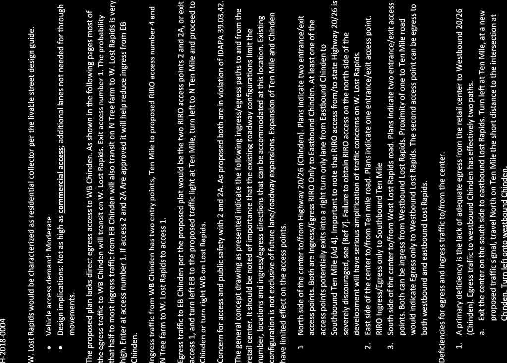
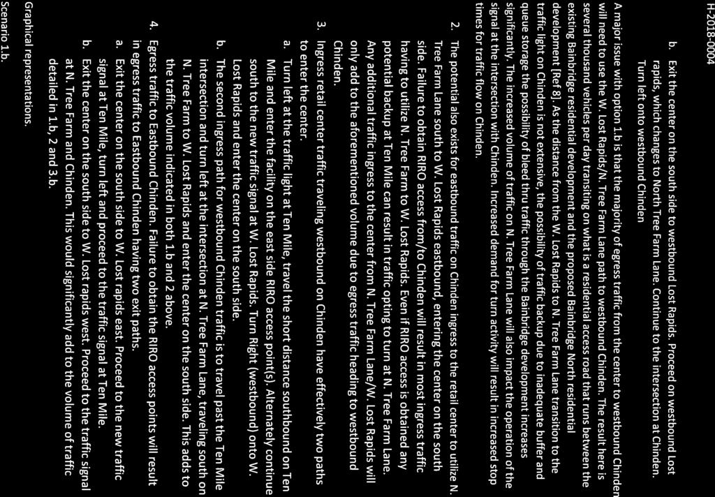
|
|
|
- Allison McLaughlin
- 5 years ago
- Views:
Transcription


1 Committed to Service Sara M. Baker, President Rebecca W. Arnold, Vice President Jim D. Hansen, Commissioner Kent Goldthorpe, Commissioner Paul Woods, Commissioner February 21, 2018 Development Services TO: FROM: ACHD Commission Mindy Wallace, AICP SUBJECT: Lost Rapids Subdivision Staff Report for February 28, 2018 Commission Meeting Executive Summary This is a preliminary plat application to allow for the development of a 15 lot mixed use subdivision consisting of 1 multifamily residential lot, 13 commercial lots, and 1 other lot on approximately 32 acres. This subdivision is proposed to be constructed in phases with the first phase consisting of a Costco Wholesale store and fueling station. The applicant and staff are in agreement on all findings for consideration and site specific conditions of approval and this item is on the regular agenda to allow testimony from area property owners. Recommendation Staff recommends approval of the staff report, as written. Attachment(s): Staff Report Letter from Area Property Owners COMPASS Checklist

2 Development Services Department Project/File: Lead Agency: Site address: Lost Rapids Subdivision/MPP /H PP This is a preliminary plat application to allow for the development of a 15 lot mixed use subdivision consisting of 1 multifamily residential lot, 13 commercial lots, and 1 other lot on approximately 32 acres. City of Meridian S/W/C Chinden Boulevard and Ten Mile Road Commission Hearing: February 28, 2018 Regular Agenda Applicant: Trevor Gasser GFI Meridian Investments II, LLC 74 East 500 South, STE 200 Bountiful, UT Mike Wardle Brighton Investments, LLC West Explorer Drive, STE 200 Boise, ID Representative: Kelly Kehrer KM Engineering 9233 West State Street Boise, ID Staff Contact: A. Findings of Fact Mindy Wallace, AICP Phone: mwallace@achdidaho.org 1. Description of Application: This is a preliminary plat application to allow for the development of a 15 lot mixed use subdivision consisting of 1 multifamily residential lot, 13 commercial lots, and 1 other lot on approximately 32 acres. This subdivision is proposed to be constructed in phases with the first phase consisting of a Costco Wholesale store and fueling station. 1 DRAFT Lost Rapids Subdivision
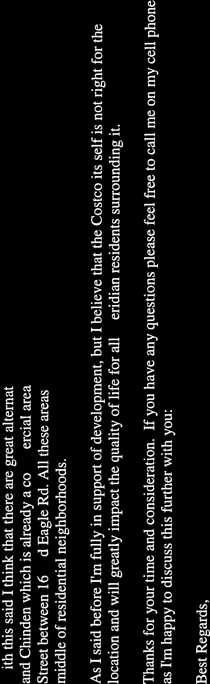
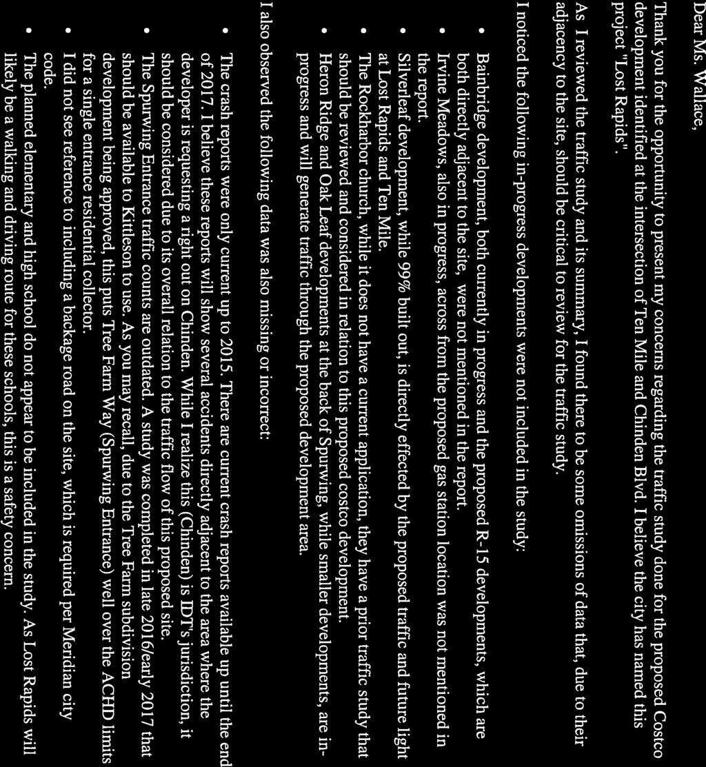
3 2. Description of Adjacent Surrounding Area: Direction Land Use Zoning North Single family residential R-4/R-15 South Church/Single family residential L-O/R-8 East Single family residential R-8 West Single family residential R-8 3. Site History: ACHD previously approved a portion of this site in 2015, as Citadel Storage at Ten Mile Subdivision, consisting of a 2 lot commercial subdivision to allow for the development of self-storage units. The requirements of this staff report differ from the previous report due to the change in proposed land uses. 4. Transit: Transit services are not available to serve this site. 5. New Center Lane Miles: The proposed development includes 0 centerline miles of new public road. 6. Impact Fees: There will be an impact fee that is assessed and due prior to issuance of any building permits. The assessed impact fee will be based on the impact fee ordinance that is in effect at that time. 7. Capital Improvements Plan (CIP)/ Integrated Five Year Work Plan (IFYWP): Ten Mile Road is scheduled in the IFYWP to be widened to 5-lanes from Ustick to McMillan Road in Ten Mile Road is scheduled in the IFYWP to be widened to 5-lanes from McMillan Road to Chinden Boulevard in Black Cat Road is listed in the CIP to be widened to 3-lanes from McMillan Road to Chinden Boulevard between 2026 and McMillan Road is listed in the CIP to be widened to 3-lanes from Black Cat Road to Ten Mile Road between 2031 and The intersection of Chinden Boulevard and Black Cat Road is listed in the CIP to be widened to 5-lanes on the north leg, 5-lanes on the south, 6-lanes east, and 6-lanes on the west leg, and signalized between 2026 and The intersection of McMillan Road and Black Cat Road is listed in the CIP to be widened to multi-lane roundabout between 2026 and B. Traffic Findings for Consideration 1. Trip Generation: This development (Costco, retail pad sites, multi-family) is estimated to generate 11,635 vehicle trips per day, 315 weekday AM peak hour trips, 1,096 weekday PM peak hour trips, and 1,485 Saturday midday peak hour trips, based on the traffic impact study. Of those trips, the Costco Wholesale store is estimated to generate 7,255 vehicle trips per day, 97 weekday AM peak hour trips, 739 weekday PM peak hour trips, and 1,019 Saturday midday peak hour trips. 2. Traffic Impact Study Kittelson & Associates prepared a traffic impact study (TIS) for the proposed Lost Rapids Development. The executive summary can be found as attachment 4. Below is a list of recommendations and mitigation measures as recommended in the analysis. ACHD has reviewed the submitted traffic impact study for consistency with ACHD policies and practices, and may have additional requirements beyond what is noted in the summary. ACHD staff comments on the submitted traffic impact study can be found below under staff comments. 2 DRAFT Lost Rapids Subdivision
4 Staff Comments/Recommendations: ACHD Traffic Services and Planning Review staff has reviewed and generally agree with the findings and recommendations of the submitted traffic impact study. The traffic study notes that the following intersections and roadway segments will exceed acceptable level of service standards in 2018 with the traffic generated by the development. Intersections: Chinden Boulevard/Black Cat Road Chinden Boulevard/Tree Farm Way Chinden Boulevard/Ten Mile Road Chinden Boulevard/Linder Road Ten Mile Road/Lost Rapids Drive Roadway Segments: Ten Mile Road Chinden Boulevard to Milano Drive Chinden Boulevard State Highway 16 to Linder Road To mitigate the impacts of the traffic generated by the Phase 1 development the applicant has proposed the following improvements: Intersections: Chinden Boulevard/Black Cat Road o Signalize the intersection Chinden Boulevard/Tree Farm Way o Widen Chinden Boulevard to 4 lanes between Linder Road and Tree Farm Way Chinden Boulevard/Ten Mile Road o Widen Chinden Boulevard to 4 lanes between Linder Road and Tree Farm Way Chinden Boulevard/Linder Road o Widen Chinden Boulevard to 4 lanes between Linder Road and Tree Farm Way Ten Mile Road/Lost Rapids Drive o Roadway Segments: Signalize the intersection Ten Mile Road Chinden Boulevard to Milano Drive o Widen Ten Mile Road to 5 lanes between Chinden Boulevard and Milano Drive Chinden Boulevard o Widen Chinden Boulevard to 4 lanes between Linder Road and Tree Farm Way A Sales Tax Anticipation Revenue Reimbursement Agreement (STAR Agreement) is proposed with ITD and ACHD to fund the improvements, see Finding for Consideration 1 below. The traffic study notes that all of the study intersections are anticipated to operate at an acceptable level of service with the construction of the proposed improvements. The widening of Ten Mile Road to 5 lanes between Chinden Boulevard and Milano Drive and Chinden Boulevard to 4 lanes between State Highway 16 and Linder Road will result in both roadways operating at an acceptable level of service. 3 DRAFT Lost Rapids Subdivision
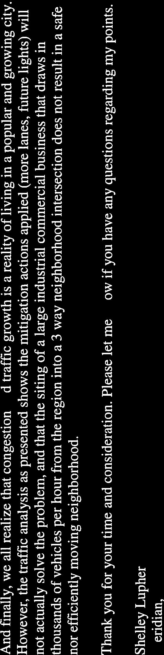
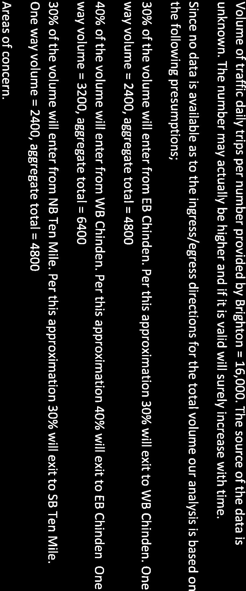
5 If the STAR agreement with ITD and ACHD does not occur, then an updated traffic impact study should be provided which shows the impact of the proposed development and proposed mitigation. The traffic impact study notes that the widening of Ten Mile Road to 5 lanes between Chinden Boulevard and Milano Drive and the signalization of the Chinden Boulevard/Black Cat Road and Ten Mile Road/Lost Rapids intersections are necessary to serve the site. If the proposed STAR agreement with ITD and ACHD does not occur, or improvements to the Chinden Boulevard/Black Cat Road intersection are removed from the agreement, then prior to ACHD s signature on the first final plat, the applicant should be required to enter into Cooperative Development Agreements (CDA) with ACHD for the signalization of the Ten Mile Road/Black Cat Road intersection to make the improvements as listed in ACHD s CIP and make interim improvement to Ten Mile Road, as listed in Finding for Consideration 4 below. 3. Trip Distribution A trip distribution analysis was included as part of the traffic impact study. The COMPASS 2040 regional travel demand model, Costco customer travel patterns, and the site plan were used in determining the trip distribution pattern. The study estimates that 39% of the site generated traffic will travel on Ten Mile Road, 60% will travel Chinden Boulevard and 1% will access the site from within the existing Bainbridge Subdivision. The exhibit below represents the trip distribution pattern presented in the traffic impact study and further defines the trip distribution. Staff Comments/Recommendations: Staff has reviewed and agrees with the trip distribution analysis presented in the traffic impact study. 4 DRAFT Lost Rapids Subdivision
6 4. Condition of Area Roadways Traffic Count is based on Vehicles per hour (VPH) Roadway **Chinden Boulevard Frontage Functional Classification * Acceptable level of service for a two-lane minor arterial is E (575 VPH). * Acceptable level of service for a three-lane minor arterial is E (720 VPH) * Acceptable level of service for a two-lane collector is D (425 VPH). ** ACHD does not set level of service thresholds for State Highways. *** Will operate at acceptable level of service with improvements identified in Finding for Consideration 4 below. 5. Average Daily Traffic Count (VDT) Average daily traffic counts are based on ACHD s most current traffic counts. The average daily traffic count for Ten Mile Road south of Chinden Boulevard was 7,692 on 2/14/18. The average daily traffic count for Black Cat Road south of Chinden Boulevard was 1,675 on 2/14/18. The average daily traffic count for McMillan Road west of Ten Mile Road was 3,229 on 2/14/18. The average daily traffic count for Lost Rapids Drive west of Ten Mile was 690 on 2/14/18. C. Findings for Consideration PM Peak Hour Traffic Count 1. Off-Site Improvements/STAR Agreement Applicant s Proposal: A STAR Agreement to fund on and off-site improvements to serve the site is being worked on by ITD. At this time staff from both ACHD and ITD are working on the proposed STAR agreement, because the proposal includes improvements to ACHD roads through the agreement. The following off-site system improvements are proposed to be constructed with the STAR Agreement: Widen Chinden Boulevard to 4 lanes between Linder Road and SH-16, with signal upgrades. o Phase 1 widening from Linder Road to Tree Farm Way. o Phase 2 widening from Tree Farm Way to SH-16. Signalization of the Chinden Boulevard/Black Cat Road intersection. PM Peak Hour Level of Service 1,135-feet Expressway N/A N/A Ten Mile Road 1,430-feet Minor Arterial 590 *** F Black Cat Road N/A Minor Arterial 120 McMillan Road N/A Minor Arterial 450 Lost Rapids Drive 1,175 Collector 30 Better than E Better than D Better than D 5 DRAFT Lost Rapids Subdivision
7 Widening of Ten Mile Road to 5-lanes between Chinden Boulevard and Milano Drive. Signalization of the Ten Mile Road/Lost Rapids Drive intersection. 2. Chinden Boulevard/US Chinden Boulevard is under the jurisdiction of the Idaho Transportation Department (ITD). The applicant, City of Meridian and ITD should work together to determine if additional right-of-way or improvements are necessary on Chinden Boulevard. Applicant s Proposal: The applicant has proposed to construct 2 driveways onto Chinden Boulevard between Tree Farm Way and Ten Mile Road. The driveways are proposed to be located 615 and 1,160-feet west of Ten Mile Road. Staff Comments/Recommendations: Comply with requirements of ITD and City of Meridian for the Chinden Boulevard frontage. Submit to the District a letter from ITD regarding said requirements prior to District approval of the final plat or plans approval, whichever occurs first. On October 18, 2017 ITD issued a letter approving the 2 proposed access points onto Chinden Boulevard (see attachment 3) with conditions. The driveway located 615-feet west of Ten Mile Road will be restricted to right-in/right-out only. ITD has required the construction of a right deceleration lane for this driveway. The driveway located 1,160-feet west of Ten Mile has been approved as a temporary left-in/rightin/right-out only driveway. ITD has required the construction of a center left turn lane and right deceleration lane for this driveway. The driveway will be limited to right-in/right-out only when Chinden Boulevard is widened to 3 lanes in the eastbound direction. ITD s approval of the driveways also conditioned the widening of Chinden Boulevard to 4 lanes between Tree Farm Way and Linder Road and signalization of Chinden Boulevard/Black Cat Road intersection and other improvements to Chinden Boulevard identified in the submitted traffic impact study. 3. Chinden Boulevard/Black Cat Road Intersection The traffic impact study notes that the Chinden Boulevard/Black Cat Road intersection already exceeds acceptable LOS E and will need to be improved with an interim signal. Or, as an alternative, the applicant will need to wait for ACHD to make improvements to the intersection, as listed in the CIP. This intersection is currently scheduled in ACHD s CIP to be improved with the widening and signalization of the intersection between 2026 and If the applicant moves forward with the development of the Lost Rapids Subdivision before ACHD improves the intersection the applicant could signalize and widen the Chinden Boulevard/Black Cat Road intersection to a 3 X 3 intersection as an interim condition until ACHD moves forward with the full intersection widening project listed in the CIP. Or, if right-of-way is available, the applicant could request to enter into a cooperative development agreement (CDA) with the District to complete the full intersection widening project as identified in ACHD's CIP. The applicant should be required to improve the Chinden Boulevard/Black Cat Road intersection prior to ACHD's signature on the first final plat. As such, the applicant should be required to enter into a Cooperative Development Agreement with the District to improve the Chinden Boulevard/Black Cat Road intersection, as noted in the District s CIP, or with interim system improvements at the intersection which includes the installation of a traffic signal and turn lanes. The Cooperative Development Agreement should include the intersection construction, as well as allocation of costs. ACHD will only provide reimbursement for the costs of permanent intersection improvements consistent with the CIP. Interim improvements are not eligible for reimbursement and all costs would be the responsibility of the applicant. 6 DRAFT Lost Rapids Subdivision
8 In order to ensure the intersection will be improved when warranted, the following items must be in place prior to plans acceptance for the final plat necessitating the improvements. Cooperative Development Agreement; Financial surety provided by the applicant meeting the terms of the Cooperative Development Agreement; Dedication of all of the right-of-way necessary to complete the intersection project. If all of the right-of-way necessary to construct the Chinden Boulevard/Black Cat Road intersection as listed in the CIP is not available or able to be acquired, then the applicant will be required to install an interim signal prior to ACHD s signature on the first final plat. Additionally, the applicant will need to obtain plan approval and enter into a signal agreement with ACHD. The signal agreement should include requirements that the intersection be designed as a 3 X 3 intersection with three 12-foot wide travel lanes: one receiving lane, one dedicated left turn lane, and one thru/right lane on each approach; that the applicant is responsible for all costs associated with the hardware, design, and installation of the interim signal, and that interim improvements are not eligible for reimbursement by ACHD. In order to ensure the Chinden Boulevard/Black Cat Road intersection will be improved when warranted, the following items must be in place prior to plans acceptance for the final plat which necessitates the improvement based on the findings of the updated traffic impact study: Signal Agreement Full design and approved plans for the intersection 4. Ten Mile Road a. Existing Conditions: Ten Mile Road is improved with 2 to 5-travel lanes, vertical curb, and no curb, gutter or sidewalk abutting the site. There is 88 to 50-feet of right-of-way for Ten Mile Road (48 to 25-feet from centerline). b. Policy: Arterial Roadway Policy: District Policy states that the developer is responsible for improving all street frontages adjacent to the site regardless of whether or not access is taken to all of the adjacent streets. Master Street Map and Typology Policy: District Policy states that the design of improvements for arterials shall be in accordance with District standards, including the Master Street Map and Livable Streets Design Guide. The developer or engineer should contact the District before starting any design. Street Section and Right-of-Way Width Policy: District Policies & state that the standard 5-lane street section shall be 72-feet (back-of-curb to back-of-curb) within 96-feet of right-of-way. This width typically accommodates two travel lanes in each direction, a continuous center left-turn lane, and bike lanes on a minor arterial and a safety shoulder on a principal arterial. Right-of-Way Dedication: District Policy states that the District will provide compensation for additional right-of-way dedicated beyond the existing right-of-way along arterials listed as impact fee eligible in the adopted Capital Improvements Plan using available impact fee revenue in the Impact Fee Service Area. No compensation will be provided for right-of-way on an arterial that is not listed as impact fee eligible in the Capital Improvements Plan. 7 DRAFT Lost Rapids Subdivision
9 The District may acquire additional right-of-way beyond the site-related needs to preserve a corridor for future capacity improvements, as provided in Section Sidewalk Policy: District Policy requires a concrete sidewalk at least 5-feet wide to be constructed on both sides of all arterial streets. A parkway strip at least 6-feet wide between the back-of-curb and street edge of the sidewalk is required to provide increased safety and protection of pedestrians. Consult the District s planter width policy if trees are to be placed within the parkway strip. Sidewalks constructed next to the back-of-curb shall be a minimum of 7-feet wide. Detached sidewalks are encouraged and should be parallel to the adjacent roadway. Meandering sidewalks are discouraged. A permanent right-of-way easement shall be provided if public sidewalks are placed outside of the dedicated right-of-way. The easement shall encompass the entire area between the rightof-way line and 2-feet behind the back edge of the sidewalk. Sidewalks shall either be located wholly within the public right-of-way or wholly within an easement. Frontage Improvements Policy: District Policy states that the developer shall widen the pavement to a minimum of 17-feet from centerline plus a 3-foot wide gravel shoulder adjacent to the entire site. Curb, gutter and additional pavement widening may be required (See Section ). Minor Improvements Policy: District Policy states that minor improvements to existing streets adjacent to a proposed development may be required. These improvements are to correct deficiencies or replace deteriorated facilities. Included are sidewalk construction or replacement; curb and gutter construction or replacement; replacement of unused driveways with curb, gutter and sidewalk; installation or reconstruction of pedestrian ramps; pavement repairs; signs; traffic control devices; and other similar items. ACHD Master Street Map: ACHD Policy Section requires the Master Street Map (MSM) guide the right-of-way acquisition, arterial street requirements, and specific roadway features required through development. This segment of Ten Mile Road is designated in the MSM as a Residential Mobility Arterial with 5-lanes and on-street bike lanes, a 72-foot street section within 96-feet of right-of-way. c. Applicant Proposal: The applicant is proposing to dedicate 48-feet of right-of-way from the centerline of Ten Mile Road where necessary and to widen Ten Mile Road to 5-lanes with bike lanes, planter strips, and detached concrete sidewalks from Chinden Boulevard to Milano Drive. d. Staff Comments/Recommendations: Staff is supportive of the proposal to utilize the STAR agreement to widen Ten Mile Road to 5 lanes between Chinden Boulevard and Milano Drive, ahead of ACHD s roadway widening project scheduled in the IFYWP for widening in As part of the STAR Agreement, the applicant should be required to enter into a Cooperative Development Agreement (CDA) with ACHD for the widening of Ten Mile Road to 5 lanes between Chinden Boulevard and Milano Drive, prior to ACHD s signature on the first final plat. The Cooperative Development Agreement should include the roadway construction, contract requirements, as well as allocation of costs. ACHD will only provide reimbursement for the costs of permanent roadway improvements consistent with the IFYWP and CIP. Interim improvements are not eligible for reimbursement and all costs would be the responsibility of the applicant. In order to ensure the roadway will be improved when warranted, the following items must be in place prior plans acceptance for the final plat necessitating the improvements. 8 DRAFT Lost Rapids Subdivision
10 Cooperative Development Agreement; Financial surety provided by the applicant meeting the terms of the Cooperative Development Agreement; Dedication of all of the right-of-way necessary to complete the road widening project. If the widening of this section of Ten Mile Road is removed from the STAR agreement or if the construction of the proposed improvements isn t feasible due to the of timing of ACHD roadway construction projects in the area, then consistent with ACHD policy, the following improvements should be constructed. Dedicate right-of-way to total 48-feet from the centerline of Ten Mile Road where it currently doesn t exist abutting the site. Construct a 5-foot wide detached concrete sidewalk located a minimum of 41-feet from the centerline of Ten Mile Road abutting the site. Provide a permanent right-of-way easement for detached sidewalks located outside of the dedicated right-of-way. Construct a center left turn lane and dedicated right turn lane on Ten Mile Road for the temporary full access driveway located 660-feet north of Lost Rapids Drive. Install a signal at the Ten Mile Road/Lost Rapids Drive intersection. The applicant should be required to enter into a signal agreement with ACHD for the design, construction, and installation of the signal. The signal agreement should note that the intersection should be designed to provide a 3 X 4 intersection with three 12-foot wide travel lanes; one receiving lane, one dedicated left turn lane, and one thru/right lane on the north, south, and east approach, and with four 12-foot wide travel lanes on the west approach; one receiving lane, one dedicated left turn lane, one thru lane, and one dedicated right lane. The dedicated right turn lane on the west approach is due to the volume of right turns anticipated to occurring during peak hours. The applicant is responsible for all costs associated with the hardware, design, and installation of the signal. 5. Lost Rapids Drive a. Existing Conditions: Lost Rapids Drive is improved with 2-travel lanes, vertical curb, gutter, bike lanes, 8-foot wide planter strips, and 5-foot wide detached sidewalks abutting the site. There are center landscape islands on Lost Rapids Drive near the intersection of Ten Mile Road. There is 69 to 93-feet of right-of-way for Lost Rapids Drive (34.5 to 42.5-feet from centerline). b. Policy: Collector Street Policy: District policy states that the developer is responsible for improving all collector frontages adjacent to the site or internal to the development as required below, regardless of whether access is taken to all of the adjacent streets. Master Street Map and Typologies Policy: District policy states that if the collector street is designated with a typology on the Master Street Map, that typology shall be considered for the required street improvements. If there is no typology listed in the Master Street Map, then standard street sections shall serve as the default. Street Section and Right-of-Way Policy: District policy states that the standard right-of-way width for collector streets shall typically be 50 to 70-feet, depending on the location and width of the sidewalk and the location and use of the roadway. The right-of-way width may be reduced, with District approval, if the sidewalk is located within an easement; in which case the District will require a minimum right-of-way width that extends 2-feet behind the back-of-curb on each side. 9 DRAFT Lost Rapids Subdivision
11 The standard street section shall be 46-feet (back-of-curb to back-of-curb). This width typically accommodates a single travel lane in each direction, a continuous center left-turn lane, and bike lanes. Residential Collector Policy: District policy states that the standard street section for a collector in a residential area shall be 36-feet (back-of-curb to back-of-curb). The District will consider a 33-foot or 29-foot street section with written fire department approval and taking into consideration the needs of the adjacent land use, the projected volumes, the need for bicycle lanes, and on-street parking. Sidewalk Policy: District policy requires a concrete sidewalks at least 5-feet wide to be constructed on both sides of all collector streets. A parkway strip at least 6-feet wide between the back-of-curb and street edge of the sidewalk is required to provide increased safety and protection of pedestrians. Consult the District s planter width policy if trees are to be placed within the parkway strip. Sidewalks constructed next to the back-of-curb shall be a minimum of 7-feet wide. Detached sidewalks are encouraged and should be parallel to the adjacent roadway. Meandering sidewalks are discouraged. A permanent right-of-way easement shall be provided if public sidewalks are placed outside of the dedicated right-of-way. The easement shall encompass the entire area between the rightof-way line and 2-feet behind the back edge of the sidewalk. Sidewalks shall either be located wholly within the public right-of-way or wholly within an easement. Minor Improvements Policy: District Policy states that minor improvements to existing streets adjacent to a proposed development may be required. These improvements are to correct deficiencies or replace deteriorated facilities. Included are sidewalk construction or replacement; curb and gutter construction or replacement; replacement of unused driveways with curb, gutter and sidewalk; installation or reconstruction of pedestrian ramps; pavement repairs; signs; traffic control devices; and other similar items. ACHD Master Street Map: ACHD Policy Section requires the Master Street Map (MSM) guide the right-of-way acquisition, collector street requirements, and specific roadway features required through development. This segment of Lost Rapids/Tree Farm Way is designated in the MSM as a Residential Collector Typology with 2-lanes and on-street bike lanes, a 36-foot street section within 54-feet of right-of-way. c. Applicant Proposal: The applicant hasn t proposed any improvements to Lost Rapids Drive abutting the site, except for the signalization of the Lost Rapids Drive/Ten Mile Road intersection d. Staff Comments/Recommendations: Lost Rapids Drive is already improved with 2 travel lanes, bike lanes, curb, gutter, and detached concrete sidewalks. Therefore no additional right-of-way dedication or street improvements should be required as part of this application. Consistent with ACHD s Minor Improvement Policy, the applicant should be required to replace any broken or deteriorated portions of curb, gutter, and sidewalk on Lost Rapids Drive abutting the site. To accommodate the signalization of the Lost Rapids/Ten Mile Road intersection, the applicant should be required to remove the existing center landscape island on Lost Rapids Drive at the Ten Mile Road intersection. When the multifamily portion of the site develops, install "NO PARKING" signs on Lost Rapids Drive abutting the site. 10 DRAFT Lost Rapids Subdivision
12 6. Driveways 6.1 Ten Mile Road a. Existing Conditions: There is one existing driveway onto Ten Mile Road from the site. The driveway is located approximately 480-feet south of Chinden Boulevard in alignment with Everest Street, an existing public street located on the east side of Ten Mile Road.. b. Policy Access Points Policy: District Policy states that all access points associated with development applications shall be determined in accordance with the policies in this section and Section Access points shall be reviewed only for a development application that is being considered by the lead land use agency. Approved access points may be relocated and/or restricted in the future if the land use intensifies, changes, or the property redevelops. Access Policy: District policy states that direct access to minor arterials is typically prohibited. If a property has frontage on more than one street, access shall be taken from the street having the lesser functional classification. If it is necessary to take access to the higher classified street due to a lack of frontage, the minimum allowable spacing shall be based on Table 1a under District policy , unless a waiver for the access point has been approved by the District Commission. Driveway Location Policy: District policy requires driveways located on minor arterial roadways from a signalized intersection with a single left turn lane shall be located a minimum of 330-feet from the nearest intersection for a right-in/right-out only driveway and a minimum of 660-feet from the intersection for a full-movement driveway. District policy requires driveways located on minor arterial roadways from a signalized intersection with a dual left turn lane shall be located a minimum of 330-feet from the nearest intersection for a right-in/right-out only driveway and a minimum of 710-feet from the intersection for a full-movement driveway. Successive Driveways: District policy Table 1a, requires driveways located on minor arterial roadways with a speed limit of 40 MPH to align or offset a minimum of 330-feet from any existing or proposed driveway. Driveway Width Policy: District policy restricts high-volume driveways (100 VTD or more) to a maximum width of 36-feet and low-volume driveways (less than 100 VTD) to a maximum width of 30-feet. Curb return type driveways with 30-foot radii will be required for high-volume driveways with 100 VTD or more. Curb return type driveways with 15-foot radii will be required for low-volume driveways with less than 100 VTD. Driveway Paving Policy: Graveled driveways abutting public streets create maintenance problems due to gravel being tracked onto the roadway. In accordance with District policy, , the applicant should be required to pave the driveway its full width and at least 30- feet into the site beyond the edge of pavement of the roadway and install pavement tapers in accordance with Table 2 under District Policy Cross Access Easements/Shared Access Policy: District Policy states that cross access utilizes a single vehicular connection that serves two or more adjoining lots or parcels so that the driver does not need to re-enter the public street system. c. Applicant s Proposal: The applicant has proposed to close the existing driveway onto Ten Mile Road and to construct one new driveway onto Ten Mile Road. This driveway is proposed to serve as the primary access for Costco delivery trucks and other local venders and it proposed to be located 660-feet north of Lost Rapids Drive and 400-feet south of Everest Street, an existing public street located on the east side of Ten Mile Road. 11 DRAFT Lost Rapids Subdivision
13 d. Staff Comments/Recommendations: The applicant s proposal for the driveway meets ACHD Access Management policy, which allows ACHD to consider an additional driveway on a Minor Arterial roadway based on analysis provided in a District approved TIS. The applicant has indicated that the driveway is proposed to serve as the primary access for Costco delivery trucks and other local venders, and the TIS notes that Costco receives 12 to 17 trucks per day ranging from local delivery trucks, depot trucks, and fuel trucks. The proposed driveway would keep the delivery truck trips off of Lost Rapids Drive, which is a concern of area residents. The TIS notes that without the driveway onto Ten Mile Road, the Chinden Boulevard/Ten Mile intersection and the Ten Mile Road/Lost Rapids Drive intersection will exceed acceptable level of service standards. The location of the driveway meets ACHD s Driveway Location and Successive Driveway policies; when driveways are allowed on minor arterial roadways. The driveway should be approved, as a temporary full access driveway. The driveway should be 36 to 40-feet wide and be constructed as a curb return type driveway with a 30-foot radii and should be paved its entire width at least 30-feet into the site beyond the edge of pavement of Ten Mile Road. The temporary full access driveway may be restricted in the future as traffic conditions warrant as determined by ACHD. 6.2 Lost Rapids Drive a. Existing Conditions: There are no driveways onto Lost Rapids Drive from the site. b. Policy: Access Policy: District Policy states that all access points associated with development applications shall be determined in accordance with the policies in this section and Section Access points shall be reviewed only for a development application that is being considered by the lead land use agency. Approved access points may be relocated and/or restricted in the future if the land use intensifies, changes, or the property redevelops. District Policy states that the primary function of a collector is to intercept traffic from the local street system and carry that traffic to the nearest arterial. A secondary function is to service adjacent property. Access will be limited or controlled. Collectors may also be designated at bicycle and bus routes. Driveway Location Policy (Signalized Intersection): District policy requires driveways located on collector roadways near a signalized intersection to be located outside the area of influence; OR a minimum of 440-feet from the signalized intersection for a fullaccess driveway and a minimum of 220-feet from the signalized intersection for a rightin/right-out only driveway. Dimensions shall be measured from the centerline of the intersection to the centerline of the driveway Driveway Location Policy (Stop Controlled Intersection): District policy requires driveways located on collector roadways near a STOP controlled intersection to be located outside of the area of influence; OR a minimum of 150-feet from the intersection, whichever is greater. Dimensions shall be measured from the centerline of the intersection to the centerline of the driveway. Successive Driveways: District policy Table 1, requires driveways located on collector roadways with a speed limit of 25 MPH and daily traffic volumes greater than 100 VTD to align or offset a minimum of 245-feet from any existing or proposed driveway. Driveway Width Policy: District policy restricts high-volume driveways (100 VTD or more) to a maximum width of 36-feet and low-volume driveways (less than 100 VTD) to a maximum width of 30-feet. Curb return type driveways with 30-foot radii will be required for 12 DRAFT Lost Rapids Subdivision
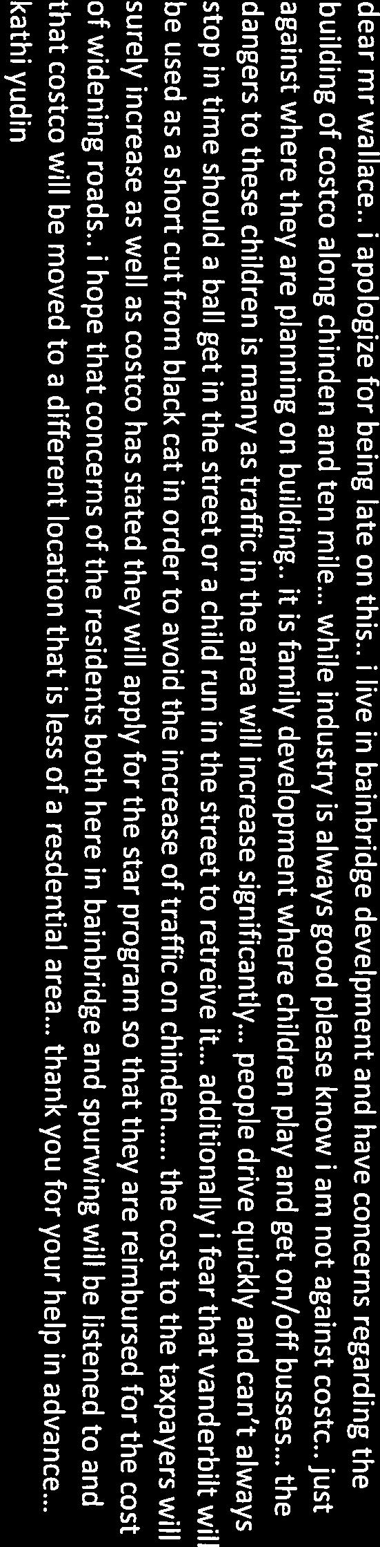
14 high-volume driveways with 100 VTD or more. Curb return type driveways with 15-foot radii will be required for low-volume driveways with less than 100 VTD. Driveway Paving Policy: Graveled driveways abutting public streets create maintenance problems due to gravel being tracked onto the roadway. In accordance with District policy, , the applicant should be required to pave the driveway its full width and at least 30- feet into the site beyond the edge of pavement of the roadway and install pavement tapers in accordance with Table 2 under District Policy c. Applicant s Proposal: The applicant has proposed to construct two driveways onto Lost Rapids Drive. One driveway is proposed to be located 350-feet west of Ten Mile Road, aligned centerline to centerline with an existing driveway on the south side of the roadway across from the site, and the second driveway is proposed to be located 700-feet west of Ten Mile Road, and is proposed to align centerline to centerline with a public street on the south side of the roadway. d. Staff Comments/Recommendations: The applicant's proposal meets ACHD policy and should be approved, as proposed. The driveways should be 36-feet wide and be constructed as a curb return type driveway with a 30-foot radii and should be paved its entire width at least 30-feet into the site beyond the edge of pavement of Lost Rapids Drive. 7. Neighborhood Concerns Residents in the area have raised several concerns regarding the development of the proposed Costco Wholesale store. Those concerns include the request for a variance to the City of Meridian to allow 2 driveways onto Chinden Boulevard/US 20-26, traffic on Chinden Boulevard/US 20-26, and increases in traffic on Ten Mile Road and Lost Rapids Drive. Chinden Boulevard is under the jurisdiction of the Idaho Transportation Department (ITD); as such ACHD has no jurisdiction over access or level of service on Chinden Boulevard. ITD has already approved the 2 driveways on to Chinden Boulevard, and required the widening of the state highway to mitigate the impacts of the proposed Lost Rapids Subdivision. The City of Meridian will need to approve a variance of their Unified Development Code to allow for the 2 driveways to be constructed. As part of this development, the applicant has proposed to widen Ten Mile Road to 5-lanes between Chinden Boulevard and Milano Drive. This improvement is proposed to be funded through a STAR Agreement and will improve the level of service and function of Ten Mile Road. If this improvement isn't made by the applicant, then interim improvements to Ten Mile Road are required as noted in Finding for Consideration 3 above and ACHD would widen this section of Ten Mile Road to 5 lanes in 2022, as scheduled in the IFYWP. Lost Rapids drive is classified as a collector roadway, and is improved with 2 travel lanes, bike lanes, curb, gutter, and detached sidewalks abutting the site. Lost Rapids Drive has a current PM peak hour traffic count of 30. ACHD policy allows up to 425 vehicle trips in the PM hour. Based on the traffic impact study at build out of the Costco Wholesale Store, Lost Rapids Drive is anticipated to carry approximately 170 vehicles in the PM peak hour operating at 40% of its available capacity. 8. Tree Planters Tree Planter Policy: Tree Planter Policy: The District s Tree Planter Policy prohibits all trees in planters less than 8-feet in width without the installation of root barriers. Class II trees may be allowed in planters with a minimum width of 8-feet, and Class I and Class III trees may be allowed in planters with a minimum width of 10-feet. 13 DRAFT Lost Rapids Subdivision
15 9. Landscaping Landscaping Policy: A license agreement is required for all landscaping proposed within ACHD right-of-way or easement areas. Trees shall be located no closer than 10-feet from all public storm drain facilities. Landscaping should be designed to eliminate site obstructions in the vision triangle at intersections. District Policy requires a 40-foot vision triangle and a 3-foot height restriction on all landscaping located at an uncontrolled intersection and a 50-foot offset from stop signs. Landscape plans are required with the submittal of civil plans and must meet all District requirements prior to signature of the final plat and/or approval of the civil plans. 10. Other Access Ten Mile Road classified as minor arterial roadway, Lost Rapids Drive is classified as collector roadway. Other than the access specifically approved with this application, direct lot access is prohibited to these roadways and should be noted on the final plat. D. Site Specific Conditions of Approval 1. Comply with requirements of ITD and City of Meridian for the Chinden Boulevard/US frontage. 2. Enter into a Cooperative Development Agreement (CDA) with ACHD for the widening of Ten Mile Road to 5 lanes between Chinden Boulevard and Milano Drive, prior to ACHD s signature on the first final plat. The Cooperative Development Agreement should include the roadway construction, contract requirements, as well as allocation of costs. ACHD will only provide reimbursement for the costs of permanent roadway improvements consistent with the IFYWP and CIP. Interim improvements are not eligible for reimbursement and all costs would be the responsibility of the applicant. In order to ensure the roadway will be improved when warranted, the following items must be in place prior plans acceptance for the final plat necessitating the improvements. Cooperative Development Agreement; Financial surety provided by the applicant meeting the terms of the Cooperative Development Agreement; Dedication of all of the right-of-way necessary to complete the road widening project. 3. If the STAR Agreement does not occur prior to ACHD's signature on the first final plat enter into a Cooperative Development Agreement with the District to improve the Chinden Boulevard/Black Cat Road intersection, as listed in the ACHD's CIP. The Cooperative Development Agreement shall include the intersection construction, as well as allocation of costs. ACHD will only provide impact fee credit for impact fee eligible costs of permanent intersection improvements consistent with CIP. 4. In order to ensure the Chinden Boulevard/Black Cat Road intersection will be improved when warranted, the following items must be in place prior plans acceptance for the final plat necessitating the improvements. Cooperative Development Agreement; Financial surety provided by the applicant meeting the terms of the Cooperative Development Agreement; Dedication of all of the right-of-way necessary to complete the intersection project. 5. If the widening of Ten Mile Road to 5 lanes between Chinden Boulevard and McMillan Road is removed from the STAR agreement or if the construction of the proposed improvements is not 14 DRAFT Lost Rapids Subdivision
16 feasible due to of timing of ACHD roadway construction projects in the area, then the following improvements shall be constructed. Dedicate right-of-way to total 48-feet from the centerline of Ten Mile Road. Construct a 5-foot wide detached concrete sidewalk located a minimum of 41-feet from the centerline of Ten Mile Road abutting the site. Provide a permanent right-of-way easement for detached sidewalks located outside of the dedicated right-of-way. Construct a center left turn lane and dedicated right turn lane on Ten Mile Road for the temporary full access driveway located 660-feet north of Lost Rapids Drive. Install a signal at the Ten Mile Road/Lost Rapids Drive intersection. The applicant should be required to enter into a signal agreement with ACHD for the design, construction, and installation of the signal. The signal agreement should note that the intersection should be designed to provide a 3 X 4 intersection with three 12-foot wide travel lanes; one receiving lane, one dedicated left turn lane, and one thru/right lane on the north, south, and east approach, and with four 12-foot wide travel lanes on the west approach; one receiving lane, one dedicated left turn lane, one thru lane, and one dedicated right lane. The applicant is responsible for all costs associated with the hardware, design, and installation of the signal. 6. Replace any broken or deteriorated portions of curb, gutter, and sidewalk on Lost Rapids Drive abutting the site. 7. Remove the existing center landscape island on Lost Rapids Drive at the Ten Mile Road intersection. 8. When the multifamily portion of the site develops, install "NO PARKING" signs on Lost Rapids Drive abutting the site. 9. Close the existing driveway onto Ten Mile Road from the site located 480-feet south of Chinden Boulevard. 10. Construct a 36 to 40-foot wide temporary full access driveway onto Ten Mile Road located 660- feet north of Lost Rapids Drive, as proposed. Construct the driveway as a curb return type driveway with a 30-foot radii and pave the driveway its entire width at least 30-feet into the site beyond the edge of pavement of Ten Mile Road. This driveway may be restricted in the future as traffic conditions warrant as determined by ACHD. 11. Construct one driveway onto Lost Rapids Drive located 350-feet west of Ten Mile Road, aligned centerline to centerline with an existing driveway on the south side Lost Rapids Drive. Construct the driveway as a curb return type driveway with a 30-foot radii and pave the driveway its entire width at least 30-feet into the site beyond the edge of pavement of Lost Rapids Drive. 12. Construct one driveway onto Lost Rapids Drive located 700-feet west of Ten Mile Road, align centerline to centerline with a public street on the south side Lost Rapids Drive. Construct the driveway as a curb return type driveway with a 30-foot radii and pave the driveway its entire width at least 30-feet into the site beyond the edge of pavement of Lost Rapids Drive. 13. Other than access approved as part of this application, direct lot access to Ten Mile Road and Lost Rapids Drive is prohibited and shall be noted on the final plat. 14. Payment of impact fees is due prior to issuance of a building permit. 15. Comply with all Standard Conditions of Approval. E. Standard Conditions of Approval 15 DRAFT Lost Rapids Subdivision
17 1. All proposed irrigation facilities shall be located outside of the ACHD right-of-way (including all easements). Any existing irrigation facilities shall be relocated outside of the ACHD right-of-way (including all easements). 2. Private Utilities including sewer or water systems are prohibited from being located within the ACHD right-of-way. 3. In accordance with District policy, , the applicant may be required to update any existing non-compliant pedestrian improvements abutting the site to meet current Americans with Disabilities Act (ADA) requirements. The applicant s engineer should provide documentation of ADA compliance to District Development Review staff for review. 4. Replace any existing damaged curb, gutter and sidewalk and any that may be damaged during the construction of the proposed development. Contact Construction Services at (with file number) for details. 5. A license agreement and compliance with the District s Tree Planter policy is required for all landscaping proposed within ACHD right-of-way or easement areas. 6. All utility relocation costs associated with improving street frontages abutting the site shall be borne by the developer. 7. It is the responsibility of the applicant to verify all existing utilities within the right-of-way. The applicant at no cost to ACHD shall repair existing utilities damaged by the applicant. The applicant shall be required to call DIGLINE ( ) at least two full business days prior to breaking ground within ACHD right-of-way. The applicant shall contact ACHD Traffic Operations in the event any ACHD conduits (spare or filled) are compromised during any phase of construction. 8. Utility street cuts in pavement less than five years old are not allowed unless approved in writing by the District. Contact the District s Utility Coordinator at (with file numbers) for details. 9. All design and construction shall be in accordance with the ACHD Policy Manual, ISPWC Standards and approved supplements, Construction Services procedures and all applicable ACHD Standards unless specifically waived herein. An engineer registered in the State of Idaho shall prepare and certify all improvement plans. 10. Construction, use and property development shall be in conformance with all applicable requirements of ACHD prior to District approval for occupancy. 11. No change in the terms and conditions of this approval shall be valid unless they are in writing and signed by the applicant or the applicant s authorized representative and an authorized representative of ACHD. The burden shall be upon the applicant to obtain written confirmation of any change from ACHD. 12. If the site plan or use should change in the future, ACHD Planning Review will review the site plan and may require additional improvements to the transportation system at that time. Any change in the planned use of the property which is the subject of this application, shall require the applicant to comply with ACHD Policy and Standard Conditions of Approval in place at that time unless a waiver/variance of the requirements or other legal relief is granted by the ACHD Commission. F. Conclusions of Law 1. The proposed site plan is approved, if all of the Site Specific and Standard Conditions of Approval are satisfied. 2. ACHD requirements are intended to assure that the proposed use/development will not place an undue burden on the existing vehicular transportation system within the vicinity impacted by the proposed development. 16 DRAFT Lost Rapids Subdivision
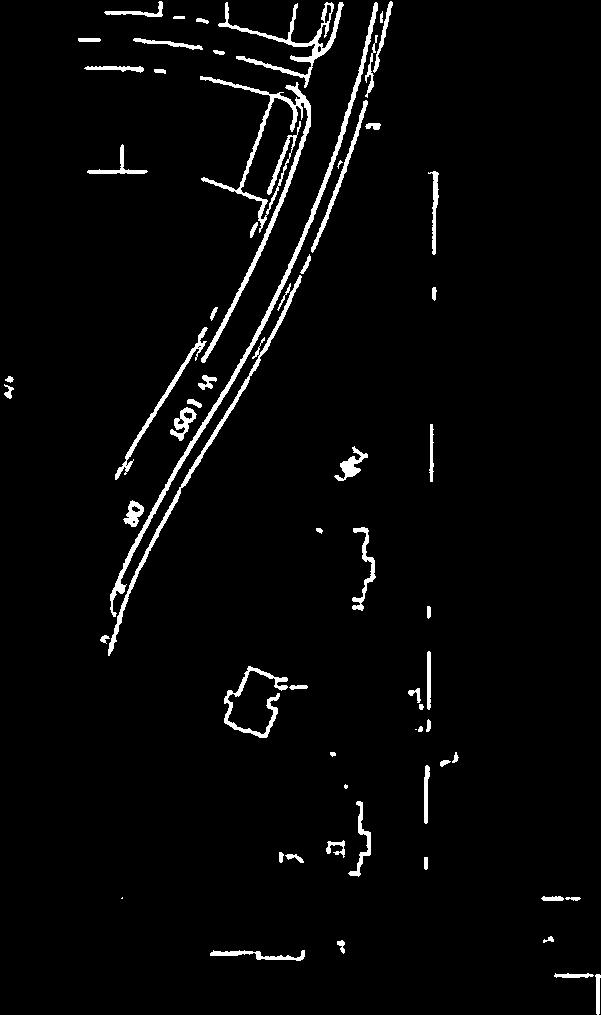
18 G. Attachments 1. Vicinity Map 2. Site Plan 3. Utility Coordinating Council 4. Development Process Checklist 5. Request for Reconsideration Guidelines VICINITY MAP 17 DRAFT Lost Rapids Subdivision

19 18 DRAFT Lost Rapids Subdivision

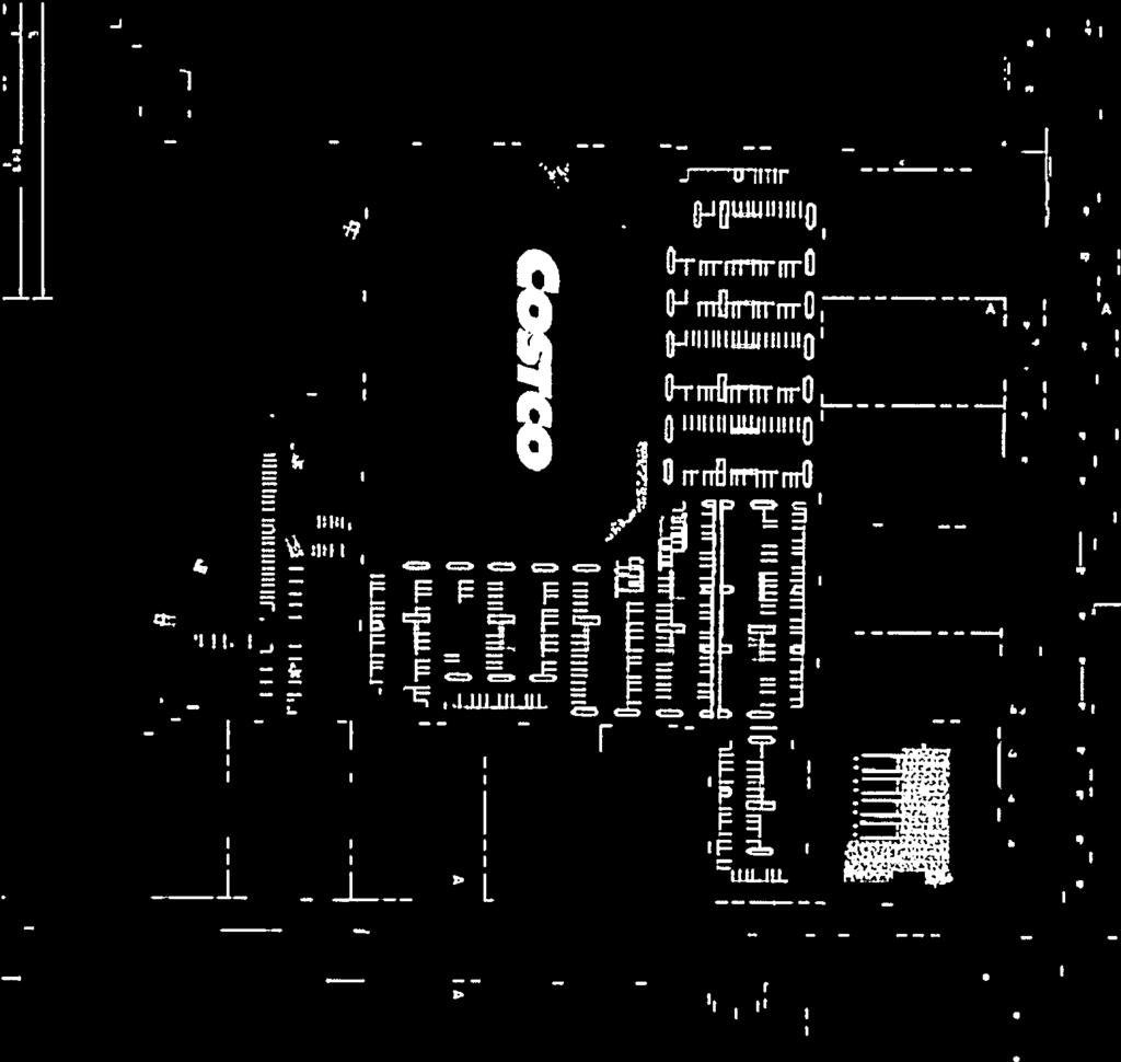
20 SITE PLAN 19 DRAFT Lost Rapids Subdivision
21 ITD Letter 20 DRAFT Lost Rapids Subdivision
22 21 DRAFT Lost Rapids Subdivision
23 22 DRAFT Lost Rapids Subdivision
24 23 DRAFT Lost Rapids Subdivision
25 Traffic Impact Study Executive Summary 24 DRAFT Lost Rapids Subdivision
26 25 DRAFT Lost Rapids Subdivision
27 26 DRAFT Lost Rapids Subdivision
28 27 DRAFT Lost Rapids Subdivision
29 28 DRAFT Lost Rapids Subdivision
30 29 DRAFT Lost Rapids Subdivision
31 30 DRAFT Lost Rapids Subdivision
32 31 DRAFT Lost Rapids Subdivision
33 32 DRAFT Lost Rapids Subdivision
34 33 DRAFT Lost Rapids Subdivision
35 34 DRAFT Lost Rapids Subdivision
36 Ada County Utility Coordinating Council Developer/Local Improvement District Right of Way Improvements Guideline Request Purpose: To develop the necessary avenue for proper notification to utilities of local highway and road improvements, to help the utilities in budgeting and to clarify the already existing process. 1) Notification: Within five (5) working days upon notification of required right of way improvements by Highway entities, developers shall provide written notification to the affected utility owners and the Ada County Utility Coordinating Council (UCC). Notification shall include but not be limited to, project limits, scope of roadway improvements/project, anticipated construction dates, and any portions critical to the right of way improvements and coordination of utilities. 2) Plan Review: The developer shall provide the highway entities and all utility owners with preliminary project plans and schedule a plan review conference. Depending on the scale of utility improvements, a plan review conference may not be necessary, as determined by the utility owners. Conference notification shall also be sent to the UCC. During the review meeting the developer shall notify utilities of the status of right of way/easement acquisition necessary for their project. At the plan review conference each company shall have the right to appeal, adjust and/or negotiate with the developer on its own behalf. Each utility shall provide the developer with a letter of review indicating the costs and time required for relocation of its facilities. Said letter of review is to be provided within thirty calendar days after the date of the plan review conference. 3) Revisions: The developer is responsible to provide utilities with any revisions to preliminary plans. Utilities may request an updated plan review meeting if revisions are made in the preliminary plans which affect the utility relocation requirements. Utilities shall have thirty days after receiving the revisions to review and comment thereon. 4) Final Notification: The developer will provide highway entities, utility owners and the UCC with final notification of its intent to proceed with right of way improvements and include the anticipated date work will commence. This notification shall indicate that the work to be performed shall be pursuant to final approved plans by the highway entity. The developer shall schedule a preconstruction meeting prior to right of way improvements. Utility relocation activity shall be completed within the times established during the preconstruction meeting, unless otherwise agreed upon. Notification to the Ada County UCC can be sent to: 50 S. Cole Rd. Boise 83707, or Visit iducc.com for notification information. 35 DRAFT Lost Rapids Subdivision
37 Development Process Checklist Items Completed to Date: Submit a development application to a City or to Ada County The City or the County will transmit the development application to ACHD The ACHD Planning Review Section will receive the development application to review The Planning Review Section will do one of the following: Send a No Review letter to the applicant stating that there are no site specific conditions of approval at this time. Write a Staff Level report analyzing the impacts of the development on the transportation system and evaluating the proposal for its conformance to District Policy. Write a Commission Level report analyzing the impacts of the development on the transportation system and evaluating the proposal for its conformance to District Policy. Items to be completed by Applicant: For ALL development applications, including those receiving a No Review letter: The applicant should submit one set of engineered plans directly to ACHD for review by the Development Review Section for plan review and assessment of impact fees. (Note: if there are no site improvements required by ACHD, then architectural plans may be submitted for purposes of impact fee assessment.) The applicant is required to get a permit from Construction Services (ACHD) for ANY work in the right-ofway, including, but not limited to, driveway approaches, street improvements and utility cuts. Pay Impact Fees prior to issuance of building permit. Impact fees cannot be paid prior to plan review approval. DID YOU REMEMBER: Construction (Non-Subdivisions) Driveway or Property Approach(s) Submit a Driveway Approach Request form to ACHD Construction (for approval by Development Services & Traffic Services). There is a one week turnaround for this approval. Working in the ACHD Right-of-Way Four business days prior to starting work have a bonded contractor submit a Temporary Highway Use Permit Application to ACHD Construction Permits along with: a) Traffic Control Plan b) An Erosion & Sediment Control Narrative & Plat, done by a Certified Plan Designer, if trench is >50 or you are placing >600 sf of concrete or asphalt. Construction (Subdivisions) Sediment & Erosion Submittal At least one week prior to setting up a Pre-Construction Meeting an Erosion & Sediment Control Narrative & Plan, done by a Certified Plan Designer, must be turned into ACHD Construction to be reviewed and approved by the ACHD Stormwater Section. Idaho Power Company Vic Steelman at Idaho Power must have his IPCO approved set of subdivision utility plans prior to Pre-Con being scheduled. Final Approval from Development Services is required prior to scheduling a Pre-Con. 36 DRAFT Lost Rapids Subdivision
38 Request for Reconsideration of Commission Action 1. Request for Reconsideration of Commission Action: A Commissioner, a member of ACHD staff or any other person objecting to any final action taken by the Commission may request reconsideration of that action, provided the request is not for a reconsideration of an action previously requested to be reconsidered, an action whose provisions have been partly and materially carried out, or an action that has created a contractual relationship with third parties. a. Only a Commission member who voted with the prevailing side can move for reconsideration, but the motion may be seconded by any Commissioner and is voted on by all Commissioners present. If a motion to reconsider is made and seconded it is subject to a motion to postpone to a certain time. b. The request must be in writing and delivered to the Secretary of the Highway District no later than 11:00 a.m. 2 days prior to the Commission s next scheduled regular meeting following the meeting at which the action to be reconsidered was taken. Upon receipt of the request, the Secretary shall cause the same to be placed on the agenda for that next scheduled regular Commission meeting. c. The request for reconsideration must be supported by written documentation setting forth new facts and information not presented at the earlier meeting, or a changed situation that has developed since the taking of the earlier vote, or information establishing an error of fact or law in the earlier action. The request may also be supported by oral testimony at the meeting. d. If a motion to reconsider passes, the effect is the original matter is in the exact position it occupied the moment before it was voted on originally. It will normally be returned to ACHD staff for further review. The Commission may set the date of the meeting at which the matter is to be returned. The Commission shall only take action on the original matter at a meeting where the agenda notice so provides. e. At the meeting where the original matter is again on the agenda for Commission action, interested persons and ACHD staff may present such written and oral testimony as the President of the Commission determines to be appropriate, and the Commission may take any action the majority of the Commission deems advisable. f. If a motion to reconsider passes, the applicant may be charged a reasonable fee, to cover administrative costs, as established by the Commission. 37 DRAFT Lost Rapids Subdivision
39

40

41
42
43


44

45

46

47
48
49


50

51
52
53

54
55
56
57

58


59


60
61
62


63


64
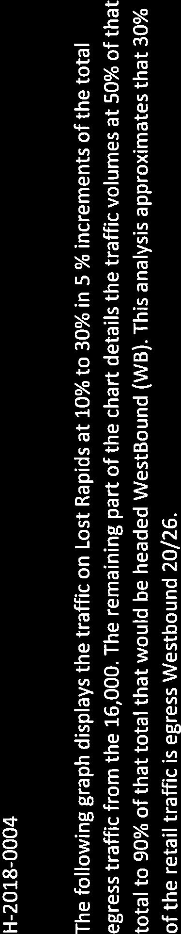
, the regional long-range")


65 Communities in Motion 2040 Development Review The Community Planning Association of Southwest Idaho (COMPASS) is the metropolitan planning organization (MPO) for Ada and Canyon Counties. COMPASS has developed this review as a tool for local governments to evaluate whether land developments are consistent with the goals of Communities in Motion 2040 (CIM 2040), the regional long-range transportation plan for Ada and Canyon Counties. This checklist is not intended to be prescriptive, but rather a guidance document based on CIM 2040 goals. Development Name: Lost Rapids Agency: Meridian CIM Vision Category: Future Neighborhoods New households: 400 New jobs: 500 Exceeds CIM forecast: YES CIM Corridor: US 20/26 Pedestrian level of stress: R-US 20/26 Bicycle level of stress: R-US 20/26 Housing within 1 mile: 1,601 Jobs within 1 mile: 783 Jobs/Housing Ratio: 0.5 Nearest police station: 2.2 miles Nearest fire station: 1.3 miles Farmland consumed: No Farmland within 1 mile: 338 acres Farmland Value: N/A Nearest bus stop: >4 miles Nearest public school: 0.6 miles Nearest public park: 0.3 mile Nearest grocery store: 0.9 miles Level of Stress considers facility type, number of vehicle lanes, and speed. Roads with G or PG ratings better support bicyclists and pedestrians of all ages and comfort levels. A good jobs/housing balance a ratio between 1 and 1.5 reduces traffic congestion. Higher numbers indicate the need for more housing and lower numbers indicate an employment need. Developments within 1.5 miles of police and fire stations ensure that emergency services are more efficient and reduce the cost of these important public services. Farmland contributes to the local economy, creates additional jobs, and provides food security to the region. Development in farm areas decreases the productivity and sustainability of farmland. Residents who live or work less than ½ mile from critical services have more transportation choices. Walking and biking reduces congestion by taking cars off the road, while supporting a healthy and active lifestyle. Recommendations This property requests access to US Highway 20/26 and Ten Mile Road. US 20/26 is identified as the #3 priority in the region in the Communities in Motion 2040 transportation plan as it is one of a few east-west roadways that stretch from Caldwell to Boise. Its role as an alternate to I-84 makes it a vital transportation route, supporting more regional travel in the Treasure Valley than any other arterial roadway. The Idaho Transportation Department has identified funding for US 20/26 to be widened from two lanes to four lanes from Star Road to Locust Grove Road. Consider reducing the three access points onto US 20/26 and/or requiring access points to be right-in, rightout only. Access management controls will support efficiency of travelers on the roadway and multi-modal safety. Ten Mile Road is also an arterial roadway. More information about COMPASS and Communities in Motion 2040: Web: info@compassidaho.org More information about the development review process:
Committed to Service
 Committed to Service Sara M. Baker, President Rebecca W. Arnold, Vice President Jim D. Hansen, Commissioner Kent Goldthorpe, Commissioner Paul Woods, Commissioner February 21, 2018 Development Services
ACHD Board of Commissioners Stacey Yarrington, Planner III Tandem Ridge/ EPP / PP-07-16/ RZ-12-16/ CPA-01-16/ A-07-16
 Development Services Department DATE: December 14, 2016 TO: FROM: SUBJECT: ACHD Board of Commissioners Stacey Yarrington, Planner III Tandem Ridge/ EPP16-0012/ PP-07-16/ Executive Summary: This is an annexation,
BPP / SUB
 Development Services Department Project/File: Lead Agency: Site address: Millwell Place Subdivision/ BPP15-0031/ SUB15-0064 This is a preliminary plat application to allow for the development of 68 building
BOI / DRH S. 13 th Street Mixed use office/retail development with residential dormitory
 Jim D. Hansen, President Sara M. Baker, Vice President Rebecca W. Arnold, Commissioner Kent Goldthorpe, Commissioner Paul Woods, Commissioner October 21, 2015 To: Rick Nesser ISS River Partners, LLC 8312
Committed to Service
 Development Services Department Committed to Service January 19, 2016 TO: FROM: SUBJECT: ACHD Board of Commissioners Mindy Wallace, AICP Planner III Kirsten Subdivision/BPP15-0023 Executive Summary: The
Development Services Department
 Kent Goldthorpe, President Paul Woods, Vice President Rebecca W. Arnold, Commissioner Sara M. Baker, Commissioner Jim D. Hansen, Commissioner July 21, 2016 Development Services Department To: From: ACHD
 Development Services Department Project/File: Lead Agency: Site address: Fall Creek Subdivision (MPP-12-016) This is a preliminary plat application to subdivision approximately 110 acres into 296 residential
 Development Services Department Project/File: Lead Agency: Site address: Aralar Park/SUB13-00048 This is a preliminary plat application to construct 55 buildable lots and 6 common lots on 12.67 acres.
Committed to Service
 Development Services Department Committed to Service June 30, 2014 TO: FROM: SUBJECT: ACHD Board of Commissioners Christy Little Planning Review Supervisor Victory Middle School/MCUP-14-003 DATE: July
 Development Services Department Project/File: Lead Agency: Site address: Applicant: Memory Ranch / KPP15-0003 / 15-02-AN / 15-01-S The applicant is requesting annexation of approximately 10 acres, rezoning
Committed to Service
 Committed to Service Paul Woods, President Rebecca W. Arnold, Vice President Sara M. Baker, Commissioner Jim D. Hansen, Commissioner Kent Goldthorpe, Commissioner September 19, 2017 Development Services
Development Services Department
 Kent Goldthorpe, President Paul Woods, Vice President Rebecca W. Arnold, Commissioner Sara M. Baker, Commissioner Jim D. Hansen, Commissioner July 28, 2016 Development Services Department To: From: ACHD
BPP / SUB /CAR /PUD
 Development Services Department Project/File: Lead Agency: Site address: Roe Street Townhomes/ BPP16-0023/ SUB16-00046/CAR16-00023/PUD16-00022 This is a rezone, preliminary plat, and planned unit development
Committed to Service
 Committed to Service Kent Goldthorpe, President Paul Woods, Vice President Rebecca W. Arnold, Commissioner Sara M. Baker, Commissioner Jim D. Hansen, Commissioner May 24, 2017 Development Services TO:
Committed to Service
 Development Services Department Committed to Service TO: FROM: Ada County Highway District Commissioners Mindy Wallace, AICP Planner III COMISSION HEARING: January 27, 2016 SUBJECT: Syringa Valley Specific
2. Caven Ridge Estates Subdivision No. 1 adds 0.54 centerline miles to the ACHD roadway system.
 Kent Goldthorpe, President Paul Woods, Vice President Rebecca W. Arnold, Commissioner Sara M. Baker, Commissioner Jim D. Hansen, Commissioner October 12, 2016 Development Services Department To: From:
Development Services Department
 Development Services Department Project/File: Lead Agency: Site address: Harris Ranch Specific Area Plan Text Amendments/ZOA14-00001 The applicant is requesting approval of a text amendment application
Roadway Classification Design Standards and Policies. Pueblo, Colorado November, 2004
 Roadway Classification Design Standards and Policies Pueblo, Colorado November, 2004 Table of Contents Page Chapter 1. General Provisions 1.1 Jurisdiction 3 1.2 Purpose and Intent 3 1.3 Modification 3
December 2, ACHD Board of Commissioners. Lauren Watsek Planner I. PUD (Deep Green Condominiums) Executive Summary:
 Executive Summary:") Development Services Department December 2, 2013 TO: FROM: SUBJECT: ACHD Board of Commissioners Lauren Watsek Planner I PUD13-00013 (Deep Green Condominiums) Executive Summary: The applicant is requesting
Development Services Department December 2, 2013 TO: FROM: SUBJECT: ACHD Board of Commissioners Lauren Watsek Planner I PUD13-00013 (Deep Green Condominiums) Executive Summary: The applicant is requesting
2. The applicant is Corey Barton Homes, Inc. and the principal for the applicant is Corey D. Barton, President.
 Kent Goldthorpe, President Paul Woods, Vice President Rebecca W. Arnold, Commissioner Sara M. Baker, Commissioner Jim D. Hansen, Commissioner February 25, 2016 Development Services Department To: ACHD
Committed to Service
 Committed to Service Paul Woods, President Rebecca W. Arnold, Vice President Sara M. Baker, Commissioner Jim D. Hansen, Commissioner Kent Goldthorpe, Commissioner January 16, 2018 Development Services
Subdivision Staff Report
 Subdivision Staff Report Subdivision Name Plano Road Subdivision File Number SUB07-00065 Approval Preliminary Plat Lead Agency Boise City Annexation Date Pending (CAR07-00042/DA) Comp. Plan Does Not Comply
5.0 Roadway System Plan
 Southwest Boise Transportation Study Page 16 5.0 Roadway System Plan The Roadway System Plan outlines roadway improvements in the Initial Study Area. It forecasts future deficiencies on the arterial system,
SECTION 3 STREET DESIGN
 3.01 GENERAL SECTION 3 STREET DESIGN For purposes of geometric and structural design, streets shall be classified according to the following table. The City Engineer will determine the class of all proposed
WYDOT DESIGN GUIDES. Guide for. Non-NHS State Highways
 WYDOT DESIGN GUIDES Guide for Non-NHS State Highways 2014 GUIDE FOR Non-NATIONAL HIGHWAY SYSTEM (Non-NHS) STATE HIGHWAYS PRESERVATION REHABILITATION RECONSTRUCTION INTRODUCTION This Guide is directed to
Access requests to County streets and roadways are processed through one of the following methods:
 13.1 GENERAL APPLICATION PROCESS Access requests to County streets and roadways are processed through one of the following methods: A. Planned Developments may set general locations for access points.
Street Paving and Sidewalk Policy
 City Commission Policy 600 Street Paving and Sidewalk Policy DEPARTMENT: Public Works DATE ADOPTED: June 7, 1995 DATE OF LAST REVISION: December 10, 2014 Policy No. 600.01 AUTHORITY: PASS City of Tallahassee-Leon
CHAPTER 16 PEDESTRIAN FACILITIES DESIGN AND TECHNICAL CRITERIA TABLE OF CONTENTS
 CHAPTER 16 PEDESTRIAN FACILITIES DESIGN AND TECHNICAL CRITERIA TABLE OF CONTENTS Section Title Page 16.1 General... 16-1 16.1.1 AASHTO Reference... 16-1 16.1.2 ADA Requirements... 16-1 16.2 Sidewalks...
WYDOT DESIGN GUIDES. Guide for. NHS Arterial (Non-Interstate)
") WYDOT DESIGN GUIDES Guide for NHS Arterial (Non-Interstate) 2014 GUIDE FOR NATIONAL HIGHWAY SYSTEM (NHS) HIGHWAYS (NHS ARTERIALS, Non-Interstate) PRESERVATION REHABILITATION RECONSTRUCTION INTRODUCTION
WYDOT DESIGN GUIDES Guide for NHS Arterial (Non-Interstate) 2014 GUIDE FOR NATIONAL HIGHWAY SYSTEM (NHS) HIGHWAYS (NHS ARTERIALS, Non-Interstate) PRESERVATION REHABILITATION RECONSTRUCTION INTRODUCTION
This Chapter sets forth the minimum design, technical criteria and specifications to be used in the preparation of all roadway plans.
 4.1 GENERAL This Chapter sets forth the minimum design, technical criteria and specifications to be used in the preparation of all roadway plans. These Roadway Standards are for new construction and modification
Committed to Service
 Development Services Department Committed to Service November 4, 2014 TO: FROM: SUBJECT: ACHD Board of Commissioners Mindy Wallace, AICP Planner III Village Charter School/ BOI14-0105/CUP14-00046/DRH14-000324
DRAFT - CITY OF MEDFORD TRANSPORTATION SYSTEM PLAN Roadway Cross-Sections
 Roadway Cross-Sections Medford s roadway cross-section standards apply to new and reconstructed roads. The crosssections take into consideration roadway function and operational characteristics, including
MAJOR THOROUGHFARE PLAN
 MAJOR THOROUGHFARE PLAN Adopted by City Commission On November 21, 2005 Per Resolution No. 4420 Amendment to the Comprehensive Community Development Plan City of Hobbs City of Hobbs MAJOR THOROUGHFARE
SECTION 1 - TRAFFIC PLANNING
 SECTION 1 - TRAFFIC PLANNING 1.1 TRAFFIC OPERATIONS 1.1.1 Roadway Functional Classification The Multnomah County Comprehensive Framework Plan s Policy 34: Trafficways and the Functional Classification
ADA TRANSITION PLAN. For
 Page 1 of 7 ADA TRANSITION PLAN For PUBLIC WORKS DEPARTMENT 121 SW Port St. Lucie Boulevard Port St. Lucie, FL 34983 Phone: 772-871-5177 Website: www.cityofpsl.com September 2018 Table of Contents 1) Introduction
State Highway 16/McDermott Road Kuna-Mora Road to Ada/Gem County Line
 Background State Highway 16 is the main commuter route from Gem County to the Treasure Valley. An increase in traffic and accidents on this highway have been a concern for several years, and the Idaho
State Highway 16 Kuna-Mora Road to Ada/Gem County Line
 Background Update! (February 2018): This project has been partially funded; see below. State Highway 16 is the main commuter route from Gem County to the Treasure Valley. An increase in traffic and accidents
Central Arkansas Regional Transportation Study Area ROADWAY DESIGN STANDARDS And Implementation Procedures
 Central Arkansas Regional Transportation Study Area ROADWAY DESIGN STANDARDS And Implementation Procedures These standards have been prepared for the use of all jurisdictions to incorporate into their
State Highway 16 Kuna-Mora Road to Ada/Gem County Line
 Background State Highway 16 is the main commuter route from Gem County to the Treasure Valley. An increase in traffic and accidents on this highway have been a concern for several years, and the Idaho
ADA Transition Plan. City of Gainesville FY19-FY28. Date: November 5, Prepared by: City Of Gainesville Department of Mobility
 ADA Transition Plan FY19-FY28 Date: November 5, 2018 Prepared by: City Of Gainesville Department of Mobility 1.0 INTRODUCTION 1.1 BACKGROUND The federal statute known as the Americans with Disabilities
T A B L E OF C O N T E N T S
 T A B L E OF C O N T E N T S PART III SUBDIVISION REGULATIONS OF THE DEPARTMENT OF PUBLIC WORKS, C & C D PAGE PAGE Responsibility for Development of Streets......... 29 Right-of-Way Widths...... 37 Purpose...........
To: ACHD Commissioners and Director 3/14/2017. Peer Review of Highlands Neighborhood Traffic and Pedestrian Safety Plan Information Briefing
 Paul Woods, President Rebecca W. Arnold, Vice President Kent Goldthorpe, Commissioner Sara M. Baker, Commissioner Jim D. Hansen, Commissioner MEMORANDUM Engineering To: ACHD Commissioners and Director
Driveway Design Criteria
 Design Manual Chapter 5 - Roadway Design 5L - Access Management 5L-4 Driveway Design Criteria A. General For efficient and safe operations, access drives and minor public street intersections can be improved
City of Albert Lea Policy and Procedure Manual 4.10 ALBERT LEA CROSSWALK POLICY
 4.10 ALBERT LEA CROSSWALK POLICY PURPOSE: Pedestrian crosswalks are an integral part of our transportation infrastructure. To be effective and promote safety, marked crosswalks must be installed after
GWINNETT COUNTY DEPARTMENT OF TRANSPORTATION
 GWINNETT COUNTY DEPARTMENT OF TRANSPORTATION 1 of 7 June 20, 2007 GENERAL: The following guidelines shall be used in the determination of the requirement for left turn lanes for development projects and
Town of Siler City - Unified Development Ordinance ARTICLE XIV - Streets and Sidewalks
 ARTICLE XIV - Streets and Sidewalks 193 Street Classification (a) In all new subdivisions, streets that are dedicated to public use shall be classified as provided in 193(b) (1) The classification shall
This chapter describes the proposed circulation system and transportation alternatives associated with
 5.0 Circulation 5.1 OVERVIEW This chapter describes the proposed circulation system and transportation alternatives associated with West Landing, and summarize the information contained in the Existing
West Dimond Blvd Upgrade Jodhpur Street to Sand Lake Road
 West Dimond Blvd Jodhpur St to Sand Lake CSS Transportation Project Summary Municipality of Anchorage Project # 05 005 Project Manager: John Smith, P.E. (MOA PM&E) Project Administrator: Julie Makela,
State Street and Pierce Park Lane Intersection Concept Report
 State Street and Pierce Park Lane Intersection Prepared for September 2017 Prepared by CITATION Parametrix. 2017. State Street & Pierce Park Lane Intersection. Prepared by Parametrix, Boise, ID. September
4APNOIPF Vh, YII PTC CITY COUNCIL AGENDA REPORT. Honorable Mayor and City Council Members. 8K TH 63 River Crossing Bridge Replacement Project
 City of RE 4APNOIPF Vh, X` W\ YII PTC ING, CITY COUNCIL AGENDA REPORT Council Meeting Date: September 26, 2016 To: From: Agenda Item: Honorable Mayor and City Council Members Ron Rosenthal, Engineering
TRAFFIC STUDY GUIDELINES Clarksville Street Department
 TRAFFIC STUDY GUIDELINES Clarksville Street Department 9/1/2009 Introduction Traffic studies are used to help the city determine potential impacts to the operation of the surrounding roadway network. Two
4.0 TRAFFIC IMPACT STUDIES
 SECTION 4 4.0 TRAFFIC IMPACT STUDIES 4.1 TRAFFIC IMPACT STUDY REQUIREMENTS The City has established Traffic Impact Study (TIS) requirements for the purpose of ensuring that both the quantitative and qualitative
TRAFFIC CALMING GUIDE FOR TORONTO CITY OF TORONTO TRANSPORTATION SERVICES DIVISION
 TRAFFIC CALMING GUIDE FOR TORONTO CITY OF TORONTO TRANSPORTATION SERVICES DIVISION CITY OF TORONTO TRANSPORTATION SERVICES DIVISION 2016 TRAFFIC CALMING GUIDE FOR TORONTO TABLE OF CONTENTS Introduction
Recommended Roadway Plan Section 2 - Land Development and Roadway Access
 Recommended Roadway Plan Section 2 - Land Development and Roadway Access SECTION 2 Land Development and Roadway Access 2.1 Land Use and Access Management The Federal Highway Administration (FHWA) defines
INTRODUCTION THOROUGHFARE SYSTEM CLASSIFICATIONS
 INTRODUCTION The thoroughfare plan will assist public officials in the development of a specialized system for efficient and safe movement of vehicular traffic while minimizing potential conflicts with
Item to be Addressed Checklist Consideration YES NO N/A Required Description Complete Streets Guidelines
 Passaic County Complete Streets Checklist - Concept Development Project Name Item to be Addressed Checklist Consideration YES NO N/A Required Description Complete Streets Guidelines Existing Plans Have
Peer Review of Highlands Neighborhood Traffic and Pedestrian Safety Plan
 FINAL REPORT March 14, 2017 Prepared for: Ada County Highway District Prepared by: SIX MILE ENGINEERING, PA Executive Summary The (Highlands Safety Plan) developed by the Ada County Highway District (ACHD)
Clackamas County Comprehensive Plan
 ROADWAYS The County s road system permits the movement of goods and people between communities and regions, using any of a variety of modes of travel. Roads provide access to virtually all property. They
Access Management Standards
 Access Management Standards Section 1: Application of Access Standards This chapter describes the Department's access management standards for access connections on the county roadway system. The standards
Committed to Service
 Committed to Service Paul Woods, President Rebecca W. Arnold, Vice President Sara M. Baker, Commissioner Jim D. Hansen, Commissioner Kent Goldthorpe, Commissioner March 14, 2017 Planning and Programming
Public Involvement Outreach Requirements for Public Information Open House Meeting: C.N , HSIP-5003(12) 132 nd and West Center Road, Omaha
 132 nd and West Center Road, Omaha") To: NDOR Environmental From: Randy McCart, HDR Date: 4 April 2017 RE: Public Involvement Summary Report, HSIP-5003(12) 132 nd and West Center Road, Omaha; C.N. 22629 Public Involvement Outreach Requirements
To: NDOR Environmental From: Randy McCart, HDR Date: 4 April 2017 RE: Public Involvement Summary Report, HSIP-5003(12) 132 nd and West Center Road, Omaha; C.N. 22629 Public Involvement Outreach Requirements
Transportation Impact Study for Abington Terrace
 Transportation Impact Study for Abington Terrace Abington Township, Montgomery County, PA Sandy A. Koza, P.E., PTOE PA PE License Number PE059911 Prepared by McMahon Associates, Inc. 425 Commerce Drive,
Poor pavement condition Substandard Intersections. / Substandard bike/pedestrian/transit accommodations. Driveway access Environmental concerns
 Public Informational Meeting University Avenue (Allen Boulevard Segoe Road) March 23, 2011 City of Madison City of Middleton Village of Shorewood Hills Dane County Existing Roadway Conditions Poor pavement
Exhibit B: Proposed amendments to the Transportation Element of the Oakland Comprehensive Plan
 Exhibit B: Proposed amendments to the Transportation Element of the Oakland Comprehensive Plan TRANSPORTATION Introduction An important aspect of any community is its transportation system, the means by
Houma-Thibodaux Metropolitan Planning Organization STP<200K Funding Application APPLICATION
 APPLICATION HOUMA-THIBODAUX METROPOLITAN PLANNING ORGANIZATION (HTMPO) FOR SURFACE TRANSPORTATION PROGRAM (STP
Summary: Mercer County Princeton Avenue & Spruce Street Study January 2009
 Summary: Several recent studies have assessed potential development and redevelopment opportunities in the Mercer Crossing area of Trenton, Ewing, and Lawrence. This Princeton Avenue and Spruce Street
County of Greenville South Carolina. Traffic Calming Program Neighborhood Traffic Education Program and Speed Hump Program
 County of Greenville South Carolina Traffic Calming Program Neighborhood Traffic Education Program and Speed Hump Program (rev) August 2008 I. PURPOSE The potential negative impacts from vehicular traffic
ARTICLE 24 TRANSPORTATION MANAGEMENT REGULATIONS
 ARTICLE 24 TRANSPORTATION MANAGEMENT REGULATIONS SECTION 2400 Intent To promote effective modes of transportation including safe and reasonable access between public roadways and adjacent land, transit
CHAPTER 4 TRANSPORTATION IMPACT STUDY TABLE OF CONTENTS
 CHAPTER 4 TRANSPORTATION IMPACT STUDY TABLE OF CONTENTS Section Title Page 4.1 Introduction... 4-1 4.1.1 General... 4-1 4.1.2 Applicant Responsibility... 4-1 4.1.3 Capacity and Safety Issues... 4-1 A.
Public Information Meeting. Orange Camp Road. Dr. Martin Luther King Jr. Beltway to I-4. Presented by: Volusia County August 2, 2018
 Public Information Meeting Orange Camp Road Dr. Martin Luther King Jr. Beltway to I-4 Presented by: Volusia County August 2, 2018 1 Project Goals To improve the operations and safety for Orange Camp Road
Review and Comment ACHD s FY Five Year Work Program Draft for Adoption
 Date: January 5, 2006 To: From: Mayor and City Council Karen Gallagher Planning and Development Services Meeting: January 10, 2006 Re: Review and Comment ACHD s FY 2007-2011Five Year Work Program Draft
Appendix 3 Roadway and Bike/Ped Design Standards
 Appendix 3 Roadway and Bike/Ped Design Standards OTO Transportation Plan 2040 4/20/2017 Page A3-1 Adopted Standards The adopted OTO Design Standards and Major Thoroughfare Plan are contained herein.
MUNICIPALITY OF ANCHORAGE Traffic Department MEMORANDUM
 MUNICIPALITY OF ANCHORAGE DATE: MEMORANDUM TO: FROM: SUBJECT: Anchorage Contractors, Builders, Designers, and Land Owners Robert E. Kniefel, P.E., Municipal Traffic Engineer Municipal Driveway Standards
REGIONAL BICYCLE AND PEDESTRIAN DESIGN GUIDELINES
 REGIONAL BICYCLE AND PEDESTRIAN DESIGN GUIDELINES November 16, 2011 Deb Humphreys North Central Texas Council of Governments Bicycle and Pedestrian Advisory Committee Snapshot of the Guide 1. Introduction
Access Management Regulations and Standards
 Access Management Regulations and Standards Efficient highway operation Reasonable property access Concept of Access Management The way to manage access to land development while simultaneously preserving
New Measure A Expenditure Categories DEFINITIONS OF ELIGIBLE EXPENDITURES Adopted March 8, 2007
 New Measure A Expenditure Categories DEFINITIONS OF ELIGIBLE EXPENDITURES Adopted March 8, 2007 City Street and County Road Maintenance Program The preservation and keeping of public street and road rights-of-way
10.0 CURB EXTENSIONS GUIDELINE
 10.0 CURB EXTENSIONS GUIDELINE Road Engineering Design Guidelines Version 1.0 March 2017 City of Toronto, Transportation Services City of Toronto Page 0 Background In early 2014, Transportation Services
4/14/2017 VIA . Miriam Lim, Junior Planner City of Sacramento Community Development Department 300 Richards, 3 rd Floor Sacramento, CA 95811
 4/14/2017 VIA EMAIL Miriam Lim, Junior Planner City of Sacramento Community Development Department 300 Richards, 3 rd Floor Sacramento, CA 95811 RE: Mack & Franklin Development (P17-016) Dear Ms. Lim:
Building Great Neighbourhoods BELLEVUE AND VIRGINIA PARK
 Building Great Neighbourhoods BELLEVUE AND VIRGINIA PARK This is Meeting 2 Unfortunately, some residents in Bellevue and Virginia Park received the wrong information for this public open house (Meeting
INDEX. Geometric Design Guide for Canadian Roads INDEX
 Acceleration lane, see Lanes, Acceleration Access, 8.1 Access Management and Functional Classification 8.2 Access Management by Design Classification 8.3 Access Configuration 8.4 Building Set-Back Guidelines
Chapter 2: Standards for Access, Non-Motorized, and Transit
 Standards for Access, Non-Motorized, and Transit Chapter 2: Standards for Access, Non-Motorized, and Transit The Washtenaw County Access Management Plan was developed based on the analysis of existing
Classification Criteria
 SCHEDULE D TO RECOMMENDED OFFICIAL PLAN AMENDMENT NO. 40 SCHEDULE C-4 Road Criteria Criteria Traffic Service Objective Land Service/Access Typical Daily Traffic Volume Flow characteristics Travel Speed
Villages of Pasadena Hills Financial Plan UPDATED Spring 2012 DRAFT
 36 37 38 39 40 41 42 43 44 45 46 Appendix B (Unchanged from January 2009 Adoption) 47 Projects Approved Prior to VOPH Comprehensive Plan Amendment Ashley Groves Chapel Creek Chapel Hill Farmington Hills
CITY OF VAUGHAN EXTRACT FROM COUNCIL MEETING MINUTES OF OCTOBER 30, 2012
 CITY OF VAUGHAN EXTRACT FROM COUNCIL MEETING MINUTES OF OCTOBER 30, 2012 Item 31, Report No. 39, of the Committee of the Whole, which was adopted without amendment by the Council of the City of Vaughan
122 Avenue: 107 Street to Fort Road
 : 107 Street to Fort Road November 24, 2015 4:30 8:00 p.m. Meeting Purpose Summarize project work completed to date Share results of public input from Phase 1 Share the draft concept plan and proposed
Table 1: Recommended Interim Improvement and Long Term Improvement/ROW Preservation Proposed Improvements. Recommended Interim Improvement
 Rebecca W. Arnold, President Sara M. Baker, Vice President John S. Franden, Commissioner Carol A. McKee, Commissioner Mitchell Jaurena, Commissioner June 19, 2012 Planning & Programming Department TO:
Complete Streets. Designing Streets for Everyone. Sarnia
 Complete Streets Designing Streets for Everyone Sarnia Complete Streets ~ Sarnia ~ 2018 Introduction Our City is made up of a network of streets that we use to go for a walk, cycle to work, drive to the
Highway 49, Highway 351 and Highway 91 Improvements Feasibility Study Craighead County
 Highway 49, Highway 351 and Highway 91 Improvements Feasibility Study Craighead County Executive Summary March 2015 Highway 49, Highway 351 and Highway 91 Improvements Feasibility Study Craighead County
ACTIVE TRANSPORTATION
 ACTIVE TRANSPORTATION Mobility 2040 Supported Goals Improve the availability of transportation options for people and goods. Support travel efficiency measures and system enhancements targeted at congestion
Bradford s Landing. Preliminary Plan Abandonment AB753 & AB754 MONTGOMERY COUNTY PLANNING DEPARTMENT
 Bradford s Landing Preliminary Plan 120170060 Abandonment AB753 & AB754 1 Overview Staff recommends Approval of Preliminary Plan 120170060 with revised conditions and Adoption of the Resolution. 244 lots
Solana Beach Comprehensive Active Transportation Strategy (CATS)
") Solana Beach Comprehensive Active Transportation Strategy (CATS) 3.0 Goals & Policies The Solana Beach CATS goals and objectives outlined below were largely drawn from the Solana Beach Circulation Element
Solana Beach Comprehensive Active Transportation Strategy (CATS) 3.0 Goals & Policies The Solana Beach CATS goals and objectives outlined below were largely drawn from the Solana Beach Circulation Element
Section 7 Complete Green Street Guidelines DRAFT
 Section 7 Complete Green Street Guidelines DRAFT 1 Section: 7.0 COMPLETE GREEN STREET GUIDELINES These guidelines serve as options to mitigate the environmental impact of a project as well as guide the
NEIGHBORHOOD TRAFFIC CALMING POLICY
 NEIGHBORHOOD TRAFFIC CALMING POLICY I. PURPOSE The City of Kent continually strives to strengthen and protect its neighborhoods by improving the quality of life in residential areas. Traffic conditions
Project Application. Project Location: Salem Drive (Federal Route 1101)
") Project Application General Information Municipality/Lead Agency: Hoffman Estates 1. Contact Person: Michael Hankey 2. Contact Phone: 847 252-5801 3. Contact Email: mike.hankey@hoffmanestates.org Project
Project Application General Information Municipality/Lead Agency: Hoffman Estates 1. Contact Person: Michael Hankey 2. Contact Phone: 847 252-5801 3. Contact Email: mike.hankey@hoffmanestates.org Project
Anne Arundel County BICYCLE, PEDESTRIAN, TRANSIT ASSESSMENT GUIDELINES
 Anne Arundel County BICYCLE, PEDESTRIAN, TRANSIT ASSESSMENT GUIDELINES December 2018 TABLE OF CONTENTS I. Executive Summary 3 II. When Is A Bicycle Pedestrian Transit Assessment (BPTA) Required? 4 III.
Americans with Disabilities Act Transition Plan for Public Right-of-Way Improvements
 Americans with Disabilities Act Transition Plan for Public Right-of-Way Improvements Prepared by: Public Works Department Engineering Division October 2015 Table of Contents Section I Introduction.. 3
MEMORANDUM. David Mohlenbrok, Environmental Services Manager
 MEMORANDUM DATE: August 10, 2017 TO: FROM: RE: Planning Commission Members David Mohlenbrok, Environmental Services Manager Blue Memo # 1 for Rocklin Station Project Comments Received on Initial Study/Mitigated
CITY MANUALS AND STANDARDS REVIEW
 GEORGETOWN SIDEWALK MASTER PLAN CITY MANUALS AND STANDARDS REVIEW RESOURCES AND STANDARDS As part of the Master Plan process, a review and evaluation of current City documents and policies relevant to
11/28/2016 VIA
 11/28/2016 VIA EMAIL Ethan Meltzer, Assistant Planner City of Sacramento Community Development Department 300 Richards Blvd., 3 rd Floor Sacramento, Ca 95811 RE: Natomas Corporate Center Commercial Building
Glenn Avenue Corridor Traffic Operational Evaluation
 Glenn Avenue Corridor Traffic Operational Evaluation PREPARED FOR: THE CITY OF AUBURN PREPARED BY: DECEMBER 2007 Glenn Avenue Corridor Study--Auburn, Alabama TABLE OF CONTENTS Introduction... 1 Background