Development Services Department
|
|
|
- Jason Stafford
- 5 years ago
- Views:
Transcription

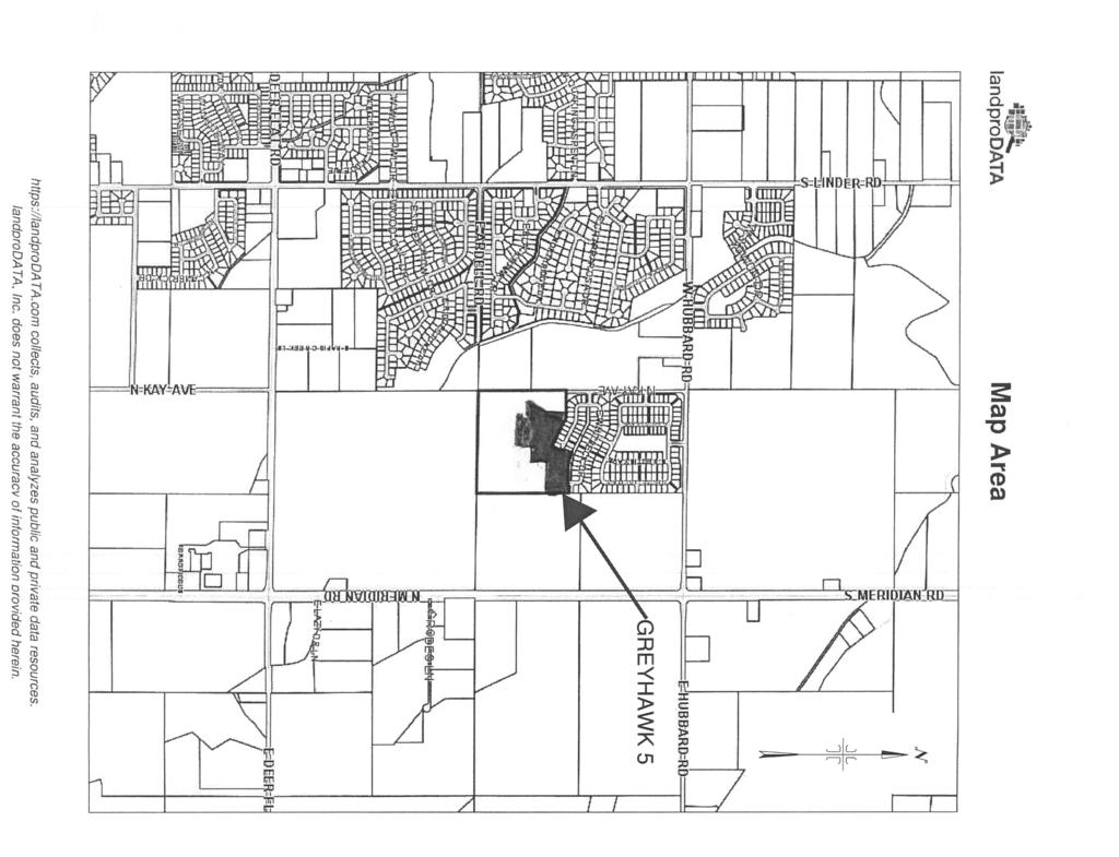
1 Kent Goldthorpe, President Paul Woods, Vice President Rebecca W. Arnold, Commissioner Sara M. Baker, Commissioner Jim D. Hansen, Commissioner July 28, 2016 Development Services Department To: From: ACHD Commission Kaci Bader, Development Review Coordinator Subject: Final Plat: Greyhawk Subdivision No. 5 Project Number: SUBP Meeting Date: August 3, 2016 FACTS & FINDINGS: 1. Greyhawk Subdivision No. 5 is a 29 buildable and 1 common lot residential subdivision on 6.35 acres. This site is located southwest of the intersection of W. Hubbard Road and S. Meridian Road. 2. Greyhawk Subdivision No. 5 adds 0.26 centerline miles to the ACHD roadway system. 3. Greyhawk Subdivision No. 5 does not have available transit. 4. The applicant is Jerry M Hess, Owner. 5. The preliminary plat was approved on September 5, All conditions of the preliminary plat have been satisfied, except for the completion of the roadway improvements. The applicant has provided a financial surety of $294,400 in the form cash in accordance with ACHD Policy Section The applicant is responsible to complete all street improvements and conditions of approval required with the preliminary plat to ACHD standards by July 15, 2017 and prior to final acceptance of the street by ACHD and release of the financial surety. RECOMMENDATION: 1. Approve the final plat of Greyhawk Subdivision No. 5 and authorize the President to endorse. ATTACHMENTS: 1. Final Plat 2. Vicinity Map 3. Greyhawk Subdivision preliminary plat, staff report dated September 5, 2006.
2
3
4
5
6
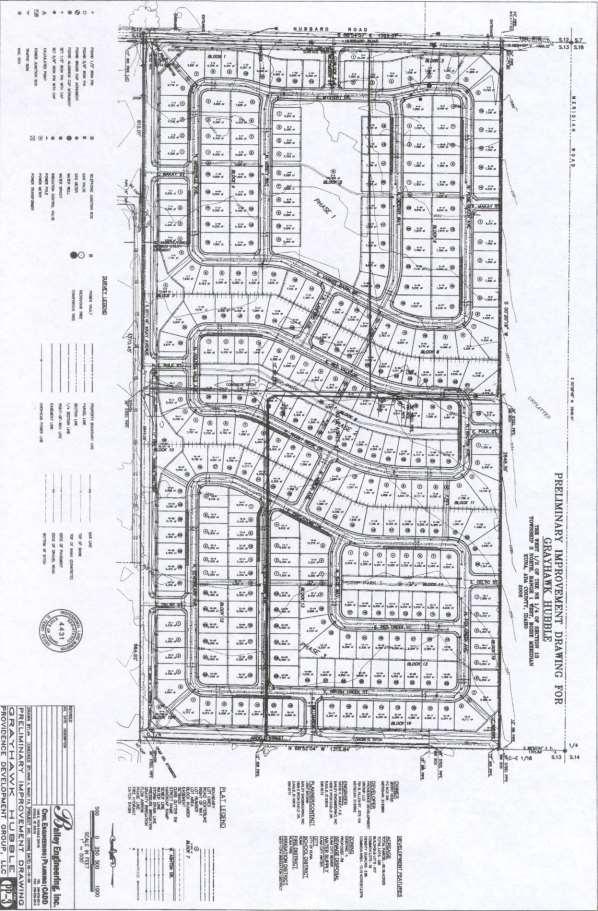
7 Right-of-Way & Development Services Department Project/File: Lead Agency: Site address: Committed to Service Greyhawk K06-S/K06-04-ZC This is a preliminary plat application for 335 single-family lots on acres. City of Kuna South of Hubbard, ½ miles east of Linder Staff Level Approval: September 5, 2006 Applicant: Representative: Staff Contact: Providence Development Group 701 S. Allen Street, Suite 104 Meridian, ID Bailey Engineering, Kent Brown 1500 E. Iron Eagle Eagle, ID Mindy Wallace Phone: mwallace@achd.ada.id.us Tech Review: September 1, 2006 Application Information: Acreage: Current Zoning: A Proposed Zoning: R-6 Residential Units: 335-single family lots Common Lots: 18 A. Findings of Fact Existing Conditions 1. Site Information: The site is currently consists of one residential dwelling unit and agricultural land. 2. Description of Adjacent Surrounding Area: Direction Land Use Zoning North Agricultural RR Ada County South Agricultural & Single-family residential RUT Ada County and R-6--City of Kuna East Agricultural RR Ada County 1 Grayhawk K06-S/K06-04-ZC
8 West Agricultural & proposed single-family residential RR Ada County and R-5 & R-6 City of Kuna 3. Existing Roadway Improvements and Right-of-Way Adjacent To and Near the Site Hubbard Road is currently improved with 2 traffic lanes, and no curb gutter or sidewalk abutting the site. There is 50-feet of right-of-way existing for Hubbard Road (25-feet from centerline). Linder Road is currently improved with 2 traffic lanes, and no curb, gutter or sidewalk. There is between 50 and 70-feet of right-of-way existing for Linder Road. Deer Flat Road currently has two travel lanes and no curb, gutter, or sidewalk. There is between 50 and 96-feet of right-of-way existing for Deer Flat Road. Meridian-Kuna (SH 69) has four travel lanes and a center turn lane with no curb, gutter or sidewalk. Meridian-Kuna (SH 69) is under the jurisdiction of the Idaho Transportation Department and has approximately 125-feet of right-of-way. 4. Existing Access: There are two defined access point to this property off of Hubbard Road. 5. Site History: ACHD has previously reviewed this site for a preliminary plat application as Durango in 2002, and Durango South in Development Impacts 6. Trip Generation: This development is estimated to generate 3,034 additional vehicle trips per day based on the submitted traffic impact study. 7. Impact Fees: There will be an impact fee that is assessed and due prior to issuance of any building permits. The assessed impact fee will be based on the impact fee ordinance that is in effect at that time. 8. Impacted Roadways: Roadway Frontage Functional Classification Traffic Count Level of Service* Speed Limit Hubbard 1330 Minor Arterial 2,032 east of Linder on Better 45 MPH 9/30/04 than C Linder None Minor Arterial 1,384 south of Better 45 MPH Columbia on 12/13/05 than C Deer Flat None Minor Arterial 6,608 west of SH 69 on Better 35 MPH 4/21/05 than C Ardell None (Will have Collector No counts available N/A 25 MPH 1,304 feet after construction) Meridian- Kuna (SH 69) None Principal Arterial 12,350 north of Deer Flat on 5/20/03 Better than C 55 MPH 13,027 north of Kay Avenue None (Will have 2,620 feet after construction) Hubbard on 5/2/02 Collector No Counts available N/A 25MPH 2 Grayhawk K06-S/K06-04-ZC
9 *Acceptable level of service for a two lane collector roadway is D (9,500 VTD). *Acceptable level of service for a two lane arterial roadway is D (14,000 VTD). *Acceptable level of service for a five lane arterial roadway is D (33,000 VTD). 9. Capital Improvements Plan/Five Year Work Program There are currently no roadways, bridges or intersections in the general vicinity of the project that are currently in the Five Year Work Program. The following improvements are scheduled in the District s Capital Improvements Plan (CIP): Deer Flat Road between Linder and Meridian is scheduled to be widened to 3-lanes in The Deer Flat/Linder Intersection is scheduled to be widened to 3-lanes on all legs and to be signalized in 11 to 20 years. The Hubbard/Meridian Intersection is schedule to be widened to 5-lanes on the north/south legs and widened to 4-lanes on the east/west legs, and to be signalized in 6-10 year. B. Findings for Consideration 1. Traffic Study A traffic impact study for Gray Hawk Subdivision was prepared by Washington Group International, below is a summary of their findings. This report is a reconstruction of the original traffic report (south portion of Durango Springs) prepared in September The original data have been updated to reflect current (2006) traffic counts and roadway conditions. The proposed development is projected to generate an average daily traffic (ADT) of 3,034 vehicle trips per day (vpd), of which the peak hour traffic (PHT) is only 320 vehicles per hour (vph). As a result of the site build out, traffic on the vicinity roadways is expected to increase. Traffic north of Lake Hazel Road may increase 1,457 vpd, north of Columbia Road may increase by 1,581 vpd, north of Deer Flat Road my increase by 173 vpd, south of Deer Flat Road may increase by 87 vpd. Traffic on Columbia Road east of Highway 69 may increase by 280 vpd. Traffic on Deer Flat west of Highway 69 may increase by 35 vpd. The intersection of Highway 69 and Lake Hazel Road is a two-way stop-controlled intersection. The WB and EB approaches are currently operating at LOS F. Improvements to the intersection are warranted to accommodate the background and build-out conditions. The Highway 69/Lake Hazel Road intersection meets the peak hour signal warrant under the existing conditions. If the Highway 69 and Lake Hazel Road intersection is signalized, the intersection will operate under capacity at background and build-out conditions for the PM peak hour. The intersection of Highway 69 and Columbia Road is a two-way stop-controlled intersection. WB and EB approaches are currently operating at LOS F. Improvements to the intersection are warranted to accommodate the background conditions. The Highway 69/Columbia intersection meets the peak hour signal warrant under the existing conditions. If the Highway 69 and Columbia Road intersection is signalized, the intersection will operate under capacity at background and build-out conditions for the PM peak hour. 3 Grayhawk K06-S/K06-04-ZC
10 The intersection of Highway 69 and Hubbard Road is a two-way stop-controlled intersection. EB and WB approaches are currently operating at LOS F. Improvements to the intersection are warranted to accommodate the build-out conditions. The highway 69/Hubbard intersection meets the peak hour signal warrant by the year 2011 with the Gray Hawk project. If the Highway 69 and Hubbard Road intersection is signalized, the intersection will operate at under capacity at build-out conditions for the PM peak hour. The intersection of Highway 69 and Deer Flat Road is currently a two-way stop controlled intersection. The signal scheduled to be operations on Friday, July 25, The Deer Flat roadway is closed for a three-week period prior to the new signal operation. The capacity analyses are based upon the conditions under the existing two-way stop control. The EB and WB approaches are currently operating at LOS F. Improvements to the intersection are warranted to accommodate the existing and background conditions. The intersection of Linder Road and Deer Flat Road is a two-way stop-controlled intersection. The EB and WB approaches are currently operating at LOS F. Improvements to the intersection are warranted to accommodate the background conditions. The Linder/Deer Flat intersection meets peak hour signal warrant by the year 2011 with the Gray Hawk project. If the Linder Road and Deer Flat Road intersection is signalized, the intersection will operate at under capacity at background and build-out conditions for the PM peak hour. The intersection of Linder Road and Hubbard Road is a two-way stop controlled intersection. The EB and WB approaches are currently operating at LOS E, and are projected to be operating at LOS F for background and build-out conditions. Improvements to the intersection are not warranted to accommodate the background conditions. Highway 69 will have adequate capacity between Deer Flat Road and Overland Road to handle traffic projections at build out. Lake Hazel, Columbia, Hubbard, and Deer Flat Roads have adequate existing capacity between arterial intersections to handle the traffic projections at build-out. The following are principal recommendations of the study: The Highway 69/Lake Hazel intersection is over capacity under the existing conditions. The Highway 69/Lake Hazel intersection meets the peak hour signal warrant at the background 2011 volumes. Signalization of the intersection by ITD/ACHD will result in an acceptable level of service. The signalized intersection can accommodate the generated site traffic volumes. The Highway 69/Columbia Road intersection is over capacity under the existing conditions. The Highway 69/Columbia intersection meets the peak hour signal warrant at the background 2011 volumes. Signalization of the intersection by ITD/ACHD will result in an acceptable level of service. The signalized intersection can accommodate the generated site traffic volumes. The highway 69/Hubbard Road intersection is over capacity under the existing conditions. The Highway 69/Hubbard intersection meets the peak hour signal warrant by year 2011 with the Gray Hawk project. Signalization by the developer of the intersection will result in an acceptable level of service. The Linder/Deer Flat Road intersection is over capacity at the projected 2011 background conditions. The Linder/Deer Flat intersection meets the peak hour signal warrant at the background 4 Grayhawk K06-S/K06-04-ZC
11 volumes. Signalization of the intersection by ITD/ACHD will result in an acceptable level of service. The signalized intersection can accommodate the generated site traffic volumes. The highway 69/Deer Flat Road intersection is over capacity at the existing and projected 2011 background conditions. The highway 69/Deer Flat intersection meets the peak hour signal warrants under existing traffic volumes. Signalization of the intersection by ITD/ACHD is currently in progress. The signal is scheduled for operation during early August The planned signalized intersection can accommodate the generated site traffic volumes. Compliance of peak hour signal warrants does not automatically justify a signal installation. A detailed signal warrant analysis will be needed when the projected traffic volumes are reached before installing a signal. All internal streets are planned for front-on-housing should have daily traffic projections less than 1000vpd. Several collectors within the development have volumes greater than 1000 vpd however; these areas do not have planned front-on-housing. The volumes entering and exiting the north site access on Hubbard Road warrant the construction of westbound right-turn lane and an eastbound left-turn lane. The volumes entering and exiting the south site access on Hubbard Road warrant the construction of a westbound left-turn lane. Both site approaches to Kay Avenue south of Hubbard Road meet the warrant for a southbound left-turn lane. Cost for any improvements (such as widening, signalization etc) at major intersection should be shared by Gray Hawk based on the composition of the intersection traffic at selected intersection. The proportionate share traffic at some selected intersection at build out are shown below. Intersection 2011 Background Traffic 2011 Gray Hawk Site Traffic Highway 69/ Overland 97% 3% Highway 69/ Lake Hazel Highway 69/ Columbia Highway 69/ Hubbard Highway 69/Deer Flat Staff Comment/Recommendation: 92% 91% 88% 99% 8% 9% 12% 1% 2. Hubbard Road Right-of-Way Policy: District policy requires 96-feet of right-of-way on arterial roadways (Figure 72-F1B). This right-of-way allows for the construction of a 5-lane roadway with curb, gutter, 5-foot concrete detached sidewalks and bike lanes. Street Section Policy: District policy 72-F3 requires arterial roadways to be constructed as a 72- foot street section with curb, gutter and 5-foot detached (or 7-foot attached) concrete sidewalk within 96-feet of right-of-way with parking prohibited on both sides of the Sidewalk Policy: District policy requires 7-foot wide attached (or 5-foot detached) concrete sidewalk on all collector roadways and arterial roadways ( ). 5 Grayhawk K06-S/K06-04-ZC
12 Applicant s Proposal: The applicant has proposed to construct Hubbard Road as a 36-foot street section within 50-feet of right-of-way. Staff Comment/Recommendation: Due to the fact that Hubbard Road does not extend beyond Black Cat Road to the west and is identified for a three mile stretch as a minor arterial roadway, the District recommends that it be a 3-lane minor arterial with bike lanes. Therefore, District policy requires 70-feet of right-of-way on (Figure 72-F1B). This right-of-way width allows for the construction of a 3-lane roadway with curb, gutter, 5-foot wide detached sidewalks and bike lanes. This recommendation is consistent with previous District action for other subdivision abutting Hubbard Road. There is currently 25-feet of right-of-way for Hubbard Road abutting the site; 10 additional feet of right-of-way will be required to be dedicated with this application. Additionally, the applicant will be required to construct a minimum 5-foot concrete sidewalk located a minimum of 28-feet from the centerline of the right-of-way. Because Hubbard Road is classified as an arterial roadway it is impact fee eligible and will be fully improved when the roadway is widened in the future. At this time the applicant will not be required to construct curb or gutter abutting the site. If the applicant chooses, they can enter into a license agreement with the District for landscaping within the right-of-way. 3. Ardell Street Residential Collector Policy: District policy 72-F1A, and , requires that residential collectors be constructed as 36-foot street sections with curb, gutter and 5-foot wide concrete sidewalks with no front-on housing. The access restrictions for these street segments should be stated on the final plat. Unless otherwise noted, parking should be prohibited on these street segments. Coordinate the signage Program with District staff. Sidewalk Policy: District policy requires 7-foot wide attached (or 5-foot detached) concrete sidewalk on all collector roadways and arterial roadways ( ). Half Street Section Policy: District policy states if a proposed development abuts an unpaved street or streets the developer shall construct one-half of the full street improvements, including curb, gutter and concrete sidewalk plus additional pavement widening beyond the centerline established for the street to provide a minimum 24-feet wide paved surface. A 3-foot wide gravel shoulder and a drainage swale sized to accommodate the roadway storm runoff shall be constructed on the unimproved side. This street section shall be constructed within a minimum 40- foot right-of-way. Applicant s Proposal: The applicant has proposed to construct Ardell Street along the site s south boundary as a half street section within 42-feet of right-of-way. Staff Comment/Recommendation: The applicant will be required to construct one-half of the full street improvements, including curb, gutter and 7-foot attached or 5-foot detached concrete sidewalk plus additional pavement widening beyond the centerline established for the street to provide a minimum 24-feet wide paved surface. A 3-foot wide gravel shoulder and a drainage swale sized to accommodate the roadway storm runoff shall be constructed on the unimproved side. This street section shall be constructed within a minimum 40-foot right-of-way. The half-street section should continue the entire length of the property abutting the site. The applicant will be required to install a barricade at east end of the roadway until the half-street section is continued with development. 6 Grayhawk K06-S/K06-04-ZC
13 4. Kay Avenue Residential Collector Street Section Policy: District policy 72-F1A, and , requires that residential collectors be constructed as 36-foot street sections with curb, gutter and 5- foot wide concrete sidewalks with no front-on housing. The access restrictions for these street segments should be stated on the final plat. Unless otherwise noted, parking should be prohibited on these street segments. Coordinate the signage Program with District staff. Half- Street Section Policy: District policy states if a proposed development abuts an unpaved street or streets the developer shall construct one-half of the full street improvements, including curb, gutter and concrete sidewalk plus additional pavement widening beyond the centerline established for the street to provide a minimum 24-feet wide paved surface. A 3-foot wide gravel shoulder and a drainage swale sized to accommodate the roadway storm runoff shall be constructed on the unimproved side. This street section shall be constructed within a minimum 40- foot right-of-way. Sidewalk Policy: District policy requires 7-foot wide attached (or 5-foot detached) concrete sidewalk on all collector roadways and arterial roadways ( ). Applicant s Proposal: The applicant has proposed to construct Kay Avenue as a half street section within 42-feet of right-of-way. Staff Comment/Recommendation: The applicant will be required to construct one-half of the full street improvements, including curb, gutter and 7-foot attached or 5-foot detached concrete sidewalk plus additional pavement widening beyond the centerline established for the street to provide a minimum 24-feet wide paved surface. A 3-foot wide gravel shoulder and a drainage swale sized to accommodate the roadway storm runoff shall be constructed on the unimproved side. Additionally, the applicant will be required to barricade the south end of the roadway until the road is continued south to Deer Flat Road. Kay Road is proposed to be extended to Hubbard Road from the north with Timbermist Subdivision. Coordinate the alignment of the Kay Avenue at the Hubbard Road intersection with Grizzly Land Co. LLC. 5. Internal Streets Right-of-Way Policy: District policy and Figure 72-F1A requires 50-feet of right-of-way on local streets. This right-of-way allows for the construction of a 2-lane roadway with curb, gutter and 5-foot wide concrete sidewalks. 36-foot Street Section Policy: District policy states, developments with any buildable lot that is less that 1-acre in size will typically provide streets having a minimum pavement width of 32- feet with curb, gutter and sidewalks. The total street width shall be 36-feet from back-of-curb to back-of-curb. Concrete sidewalks shall be a minimum of 5-feet in width unless they are separated from the curb 5-feet or more in which case the sidewalk shall be a minimum of 4-feet in width. Island Policy: District policy and require islands to be constructed a minimum of 4- feet wide with a minimum area of 100-square feet and designed to safely channel traffic. The roadway on either side of the traffic island should maintain a minimum of a 21-foot street section. District policy also requires any proposed landscape islands/medians within the public right-of-way dedicated by this plat should be owned and maintained by a homeowners association. Notes of this should be required on the final plat. The design should be reviewed and approved by ACHD's Development staff. Applicant Proposal (Internal streets): The applicant is proposing to construct the internal streets as a 36-foot street section with rolled curb, gutter, and 5-foot attached concrete sidewalks. The 7 Grayhawk K06-S/K06-04-ZC
14 applicant has also proposed one entrance roadway Williamson Street off of Hubbard Road with a center landscape island. The applicant has proposed a 21-foot street section on each side of the center landscape island. Staff Comment/Recommendation: The applicant s proposals meet District policy and should be approved with this application. 6. Tree Planters Tree Planter Policy: The District s Tree Planter Width Interim Policy prohibits all trees in planters less than 6-feet in width. In addition to prohibiting trees in planters less than 6-feet in width, the policy requires a minimum planter width of 6-feet for class II tress with the installation of root barriers on both sides of the planter strip or a minimum planter width of 8-feet without the installation of a root barrier. The policy also requires Class I and Class III trees to provide a minimum planter width of 10-feet. 7. Stub Streets Stub Street Policy: District policy states that the street design in a proposed development shall cause no undue hardship to adjoining property. An adequate and convenient access to adjoining property for use in future development may be required. If a street ends at the development boundary, it shall meet the requirements of sub section 7205, non-continuous streets. District policy states that stub streets will be required to provide intra-neighborhood circulation or to provide access to adjoining properties. Stub streets will conform with the requirements described in Section , and , except a temporary cul-de-sac will not be required if the stub street has a length no greater than 150-feet. A sign shall be installed at the terminus of the stub street stating that, "THIS ROAD WILL BE EXTENDED IN THE FUTURE. Applicant Proposal: The applicant has proposed three stub streets to the east. The stub streets are proposed to be located as follows: First stub street to the east, E. Makay Street, is proposed to be located 580-feet south of north property line (property line to centerline). Second stub street to the east, E. Polk Street, is proposed to be located 1,420-feet south of the north property line (measured property line to centerline). Third stub street to the east, E. Celtic Street, is proposed to be located 640-feet north of the south property line (measured property line to centerline). Staff Comment/Recommendation: The applicant s proposed stub street locations meet District policy and should be approved with this application. 8. Roadway Offsets Roadway Offset Policy: District policy , requires local roadways to align or offset a minimum of 300-feet from an arterial roadway (measured centerline to centerline). District policy , requires local roadways to align or offset a minimum of 125-feet from another local roadway (measured centerline to centerline). Applicant Proposal: The applicant has proposed one roadway to intersect Hubbard Road, Williamson Street, approximately 700-feet east of the west property line (measured property line to centerline). The applicant has proposed one roadway to intersect Ardell Street, Williamson Street, approximately 620-feet east of the west property line (measured property line to centerline). The applicant has proposed to construct three roadways to intersect Kay Avenue, the first, E. Makay Street, approximately 480-feet south of the north property line (measured property line to center line). The second, E. Polk Street, approximately 1,200-feet south of the north property line 8 Grayhawk K06-S/K06-04-ZC
15 (measured property line to centerline). The third, E. Celtic Street, approximately 520-feet north of the south property line (measured property line to centerline). Staff Comment/Recommendation: The applicant s proposals meet District policy and should be approved with this application. Based on the submitted traffic impact study, the applicant will be required to construct a westbound right turn lane and an eastbound left turn lane on the main entrance road (Williamson Street) intersecting Hubbard Road. Southbound left turn lanes will be required on two roadways intersecting Kay Avenue (E. Makay Street and E. Polk Street). 9. Other Access Hubbard Road is classified as minor arterial roadway, Kay Avenue and Ardell Street are classified as collector roadways. Other than the access specifically approved with this application, direct lot access is prohibited to these roadways and should be noted on the final plat. C. Site Specific Conditions of Approval 1. Dedicate a total of 35-feet of right-of-way from the centerline of Hubbard Road abutting the site. Construct a 5-foot concrete sidewalk a minimum of 28-feet from the centerline of Hubbard Road in its ultimate location abutting the side. 2. Construct Ardell Street as one-half street section with curb, gutter, and concrete sidewalk on the north side of the roadway, a minimum 24-foot of pavement, a 3-foot wide gravel shoulder and a drainage swale on the south side of the roadway within 40-feet of right-of-way. Place a barricade at the east end of the improved roadway. 3. Construct Kay Avenue as one-half street section with curb, gutter, and concrete sidewalk on the east side of the roadway, a minimum 24-feet of pavement, a 3-foot wide gravel shoulder, and a drainage swale on the west side of the roadway within 40-feet of right-of-way. Coordinate the alignment of Kay Avenue to the north at the Hubbard intersection with Grizzly Land Co. LLC. Place a barricade at the south end of the improved roadway. 4. Construct the internal streets as 36 -foot street section with curb, gutter, and 5-foot concrete sidewalk within 50-feet of right-of-way. 5. Construct one center landscape island as proposed on Williamson Street. 6. Provide 21-foot street sections on each side of the proposed center islands. Any proposed landscape islands/medians within the public right-of-way dedicated by this plat shall be owned and maintained by a homeowners association. Notes of this are required on the final plat. The design should be reviewed and approved by ACHD's Development staff. 7. Construct stub streets to the surrounding properties as identified below. Install a sign at the terminus of each roadway stating, THIS ROAD WILL BE EXTENDED IN THE FUTURE. First stub street to the east, E. Makay Street, is proposed to be located 580-feet south of north property line (property line to centerline). Second stub street to the east, E. Polk Street, is proposed to be located 1,420-feet south of the north property line (measured property line to centerline). 9 Grayhawk K06-S/K06-04-ZC
16 Third stub street to the east, E. Celtic Street, is proposed to be located 640-feet north of the south property line (measured property line to centerline). 8. Construct one roadway, Williamson Street, to intersect Hubbard Road, approximately 700-feet east of the west property line (measured property line to centerline). Construct a westbound right turn lane and a eastbound left turn lane on Williamson Street. 9. Construct one roadway, Williamson Street, to intersect Ardell Street, approximately 620-feet east of the west property line (measured property line to centerline), as proposed. 10. Construct three roadways to intersect Kay Avenue, the first, E. Makay Street, approximately 480- feet south of the north property line (measured property line to center line). The second, E. Polk Street, approximately 1,200-feet south of the north property line (measured property line to centerline). The third, E. Celtic Street, approximately 520-feet north of the south property line (measured property line to centerline). Construct southbound left turn lanes on E. Makay Street, and E. Polk Street. 11. Other than the access specifically approved with this application, direct lot access is prohibited to Hubbard Road, Kay Avenue, and Ardell Street and shall be noted on the final plat. 12. Comply with all Standard Conditions of Approval. D. Standard Conditions of Approval 1. Any existing irrigation facilities shall be relocated outside of the right-of-way. 2. Private sewer or water systems are prohibited from being located within any ACHD roadway or right-of-way. 3. All utility relocation costs associated with improving street frontages abutting the site shall be borne by the developer. 4. Replace any existing damaged curb, gutter and sidewalk and any that may be damaged during the construction of the proposed development. Contact Construction Services at (with file number) for details. 5. Comply with the District s Tree Planter Width Interim Policy. 6. Utility street cuts in pavement less than five years old are not allowed unless approved in writing by the District. Contact the District s Utility Coordinator at (with file numbers) for details. 7. All design and construction shall be in accordance with the Ada County Highway District Policy Manual, ISPWC Standards and approved supplements, Construction Services procedures and all applicable ACHD Ordinances unless specifically waived herein. An engineer registered in the State of Idaho shall prepare and certify all improvement plans. 8. The applicant shall submit revised plans for staff approval, prior to issuance of building permit (or other required permits), which incorporates any required design changes. 9. Construction, use and property development shall be in conformance with all applicable requirements of the Ada County Highway District prior to District approval for occupancy. 10 Grayhawk K06-S/K06-04-ZC
17 10. Payment of applicable road impact fees are required prior to building construction in accordance with Ordinance #200, also known as Ada County Highway District Road Impact Fee Ordinance. 11. It is the responsibility of the applicant to verify all existing utilities within the right-of-way. The applicant at no cost to ACHD shall repair existing utilities damaged by the applicant. The applicant shall be required to call DIGLINE ( ) at least two full business days prior to breaking ground within ACHD right-of-way. The applicant shall contact ACHD Traffic Operations in the event any ACHD conduits (spare or filled) are compromised during any phase of construction. 12. No change in the terms and conditions of this approval shall be valid unless they are in writing and signed by the applicant or the applicant s authorized representative and an authorized representative of the Ada County Highway District. The burden shall be upon the applicant to obtain written confirmation of any change from the Ada County Highway District. 13. Any change by the applicant in the planned use of the property which is the subject of this application, shall require the applicant to comply with all rules, regulations, ordinances, plans, or other regulatory and legal restrictions in force at the time the applicant or its successors in interest advises the Highway District of its intent to change the planned use of the subject property unless a waiver/variance of said requirements or other legal relief is granted pursuant to the law in effect at the time the change in use is sought. E. Conclusions of Law 1. The proposed site plan is approved, if all of the Site Specific and Standard Conditions of Approval are satisfied. 2. ACHD requirements are intended to assure that the proposed use/development will not place an undue burden on the existing vehicular transportation system within the vicinity impacted by the proposed development. Attachments 1. Vicinity Map 2. Site Plan 3. Request for Reconsideration Guidelines OR Appeal Guidelines 4. Development Process Checklist 11 Grayhawk K06-S/K06-04-ZC
18 12 Grayhawk K06-S/K06-04-ZC
19 13 Grayhawk K06-S/K06-04-ZC
20 Development Process Checklist Submit a development application to a City or to the County The City or the County will transmit the development application to ACHD The ACHD Planning Review Division will receive the development application to review The Planning Review Division will do one of the following: Send a No Review letter to the applicant stating that there are no site specific requirements at this time. Send a Comply With letter to the applicant stating that if the development is within a platted subdivision or part of a previous development application and that the site specific requirements from the previous development also apply to this development application. Write a Staff Level report analyzing the impacts of the development on the transportation system and evaluating the proposal for its conformance to District Policy. Write a Commission Level report analyzing the impacts of the development on the transportation system and evaluating the proposal for its conformance to District Policy. The Planning Review Division will hold a Technical Review meeting for all Staff and Commission Level reports. For ALL development applications, including those receiving a No Review or Comply With letter: The applicant should submit two (2) sets of engineered plans directly to ACHD for review by the Development Review Division for plan review and assessment of impact fees. (Note: if there are no site improvements required by ACHD, then architectural plans may be submitted for purposes of impact fee calculation.) The applicant is required to get a permit from Construction Services (ACHD) for ANY work in the right-of-way, including, but not limited to, driveway approaches, street improvements and utility cuts. Pay Impact Fees prior to issuance of building permit. Impact fees cannot be paid prior to plan review approval. DID YOU REMEMBER: Construction (Zone) Driveway or Property Approach(s) Submit a Driveway Approach Request form to Ada County Highway District (ACHD) Construction (for approval by Development Services & Traffic Services). There is a one week turnaround for this approval. Working in the ACHD Right-of-Way Four business days prior to starting work have a bonded contractor submit a Temporary Highway Use Permit Application to ACHD Construction Permits along with: a) Traffic Control Plan b) An Erosion & Sediment Control Narrative & Plat, done by a Certified Plan Designer, if trench is >50 or you are placing >600 sf of concrete or asphalt. Construction (Subdivisions) Sediment & Erosion Submittal At least one week prior to setting up a Pre-Con an Erosion & Sediment Control Narrative & Plat, done by a Certified Plan Designer, must be turned into ACHD Construction Subdivision to be reviewed and approved by the ACHD Drainage Division. Idaho Power Company Vic Steelman at Idaho Power must have his IPCO approved set of subdivision utility plans prior to Pre-Con being scheduled. Final Approval from Development Services ACHD Construction Subdivision must have received approval from Development Services prior to scheduling a Pre-Con. 14 Grayhawk K06-S/K06-04-ZC
21 Request for Appeal of Staff Decision 1. Appeal of Staff Decision: The Commission shall hear and decide appeals by an applicant of the final decision made by the ROWDS Manager when it is alleged that the ROWDS Manager did not properly apply this section , did not consider all of the relevant facts presented, made an error of fact or law, abused discretion or acted arbitrarily and capriciously in the interpretation or enforcement of the ACHD Policy Manual. a. Filing Fee: The Commission may, from time to time, set reasonable fees to be charged the applicant for the processing of appeals, to cover administrative costs. b. Initiation: An appeal is initiated by the filing of a written notice of appeal with the Secretary of Highway Systems, which must be filed within ten (10) working days from the date of the decision that is the subject of the appeal. The notice of appeal shall refer to the decision being appealed, identify the appellant by name, address and telephone number and state the grounds for the appeal. The grounds shall include a written summary of the provisions of the policy relevant to the appeal and/or the facts and law relied upon and shall include a written argument in support of the appeal. The Commission shall not consider a notice of appeal that does not comply with the provisions of this subsection. c. Time to Reply: The ROWDS Manager shall have ten (10) working days from the date of the filing of the notice of appeal to reply to the notice of the appeal, and may during such time meet with the appellant to discuss the matter, and may also consider and/or modify the decision that is being appealed. A copy of the reply and any modifications to the decision being appealed will be provided to the appellant prior to the Commission hearing on the appeal. d. Notice of Hearing: Unless otherwise agreed to by the appellant, the hearing of the appeal will be noticed and scheduled on the Commission agenda at a regular meeting to be held within thirty (30) days following the delivery to the appellant of the ROWDS Manager s reply to the notice of appeal. A copy of the decision being appealed, the notice of appeal and the reply shall be delivered to the Commission at least one (1) week prior to the hearing. e. Action by Commission: Following the hearing, the Commission shall either affirm or reverse, in whole or part, or otherwise modify, amend or supplement the decision being appealed, as such action is adequately supported by the law and evidence presented at the hearing. 15 Grayhawk K06-S/K06-04-ZC
22 16 Grayhawk K06-S/K06-04-ZC
BOI / DRH S. 13 th Street Mixed use office/retail development with residential dormitory
 Jim D. Hansen, President Sara M. Baker, Vice President Rebecca W. Arnold, Commissioner Kent Goldthorpe, Commissioner Paul Woods, Commissioner October 21, 2015 To: Rick Nesser ISS River Partners, LLC 8312
BPP / SUB
 Development Services Department Project/File: Lead Agency: Site address: Millwell Place Subdivision/ BPP15-0031/ SUB15-0064 This is a preliminary plat application to allow for the development of 68 building
Development Services Department
 Kent Goldthorpe, President Paul Woods, Vice President Rebecca W. Arnold, Commissioner Sara M. Baker, Commissioner Jim D. Hansen, Commissioner July 21, 2016 Development Services Department To: From: ACHD
2. Caven Ridge Estates Subdivision No. 1 adds 0.54 centerline miles to the ACHD roadway system.
 Kent Goldthorpe, President Paul Woods, Vice President Rebecca W. Arnold, Commissioner Sara M. Baker, Commissioner Jim D. Hansen, Commissioner October 12, 2016 Development Services Department To: From:
ACHD Board of Commissioners Stacey Yarrington, Planner III Tandem Ridge/ EPP / PP-07-16/ RZ-12-16/ CPA-01-16/ A-07-16
 Development Services Department DATE: December 14, 2016 TO: FROM: SUBJECT: ACHD Board of Commissioners Stacey Yarrington, Planner III Tandem Ridge/ EPP16-0012/ PP-07-16/ Executive Summary: This is an annexation,
 Development Services Department Project/File: Lead Agency: Site address: Applicant: Memory Ranch / KPP15-0003 / 15-02-AN / 15-01-S The applicant is requesting annexation of approximately 10 acres, rezoning
BPP / SUB /CAR /PUD
 Development Services Department Project/File: Lead Agency: Site address: Roe Street Townhomes/ BPP16-0023/ SUB16-00046/CAR16-00023/PUD16-00022 This is a rezone, preliminary plat, and planned unit development
 Development Services Department Project/File: Lead Agency: Site address: Fall Creek Subdivision (MPP-12-016) This is a preliminary plat application to subdivision approximately 110 acres into 296 residential
Committed to Service. Development Services. February 21, ACHD Commission. Mindy Wallace, AICP
 Committed to Service Sara M. Baker, President Rebecca W. Arnold, Vice President Jim D. Hansen, Commissioner Kent Goldthorpe, Commissioner Paul Woods, Commissioner February 21, 2018 Development Services
2. The applicant is Corey Barton Homes, Inc. and the principal for the applicant is Corey D. Barton, President.
 Kent Goldthorpe, President Paul Woods, Vice President Rebecca W. Arnold, Commissioner Sara M. Baker, Commissioner Jim D. Hansen, Commissioner February 25, 2016 Development Services Department To: ACHD
 Development Services Department Project/File: Lead Agency: Site address: Aralar Park/SUB13-00048 This is a preliminary plat application to construct 55 buildable lots and 6 common lots on 12.67 acres.
Committed to Service
 Development Services Department Committed to Service January 19, 2016 TO: FROM: SUBJECT: ACHD Board of Commissioners Mindy Wallace, AICP Planner III Kirsten Subdivision/BPP15-0023 Executive Summary: The
Subdivision Staff Report
 Subdivision Staff Report Subdivision Name Plano Road Subdivision File Number SUB07-00065 Approval Preliminary Plat Lead Agency Boise City Annexation Date Pending (CAR07-00042/DA) Comp. Plan Does Not Comply
Committed to Service
 Development Services Department Committed to Service June 30, 2014 TO: FROM: SUBJECT: ACHD Board of Commissioners Christy Little Planning Review Supervisor Victory Middle School/MCUP-14-003 DATE: July
Committed to Service
 Committed to Service Sara M. Baker, President Rebecca W. Arnold, Vice President Jim D. Hansen, Commissioner Kent Goldthorpe, Commissioner Paul Woods, Commissioner February 21, 2018 Development Services
Committed to Service
 Committed to Service Paul Woods, President Rebecca W. Arnold, Vice President Sara M. Baker, Commissioner Jim D. Hansen, Commissioner Kent Goldthorpe, Commissioner September 19, 2017 Development Services
Committed to Service
 Committed to Service Kent Goldthorpe, President Paul Woods, Vice President Rebecca W. Arnold, Commissioner Sara M. Baker, Commissioner Jim D. Hansen, Commissioner May 24, 2017 Development Services TO:
Roadway Classification Design Standards and Policies. Pueblo, Colorado November, 2004
 Roadway Classification Design Standards and Policies Pueblo, Colorado November, 2004 Table of Contents Page Chapter 1. General Provisions 1.1 Jurisdiction 3 1.2 Purpose and Intent 3 1.3 Modification 3
Committed to Service
 Development Services Department Committed to Service TO: FROM: Ada County Highway District Commissioners Mindy Wallace, AICP Planner III COMISSION HEARING: January 27, 2016 SUBJECT: Syringa Valley Specific
Table 1: Recommended Interim Improvement and Long Term Improvement/ROW Preservation Proposed Improvements. Recommended Interim Improvement
 Rebecca W. Arnold, President Sara M. Baker, Vice President John S. Franden, Commissioner Carol A. McKee, Commissioner Mitchell Jaurena, Commissioner June 19, 2012 Planning & Programming Department TO:
This Chapter sets forth the minimum design, technical criteria and specifications to be used in the preparation of all roadway plans.
 4.1 GENERAL This Chapter sets forth the minimum design, technical criteria and specifications to be used in the preparation of all roadway plans. These Roadway Standards are for new construction and modification
Town of Siler City - Unified Development Ordinance ARTICLE XIV - Streets and Sidewalks
 ARTICLE XIV - Streets and Sidewalks 193 Street Classification (a) In all new subdivisions, streets that are dedicated to public use shall be classified as provided in 193(b) (1) The classification shall
Committed to Service
 Committed to Service Paul Woods, President Rebecca W. Arnold, Vice President Sara M. Baker, Commissioner Jim D. Hansen, Commissioner Kent Goldthorpe, Commissioner January 16, 2018 Development Services
December 2, ACHD Board of Commissioners. Lauren Watsek Planner I. PUD (Deep Green Condominiums) Executive Summary:
 Executive Summary:") Development Services Department December 2, 2013 TO: FROM: SUBJECT: ACHD Board of Commissioners Lauren Watsek Planner I PUD13-00013 (Deep Green Condominiums) Executive Summary: The applicant is requesting
Development Services Department December 2, 2013 TO: FROM: SUBJECT: ACHD Board of Commissioners Lauren Watsek Planner I PUD13-00013 (Deep Green Condominiums) Executive Summary: The applicant is requesting
Development Services Department
 Development Services Department Project/File: Lead Agency: Site address: Harris Ranch Specific Area Plan Text Amendments/ZOA14-00001 The applicant is requesting approval of a text amendment application
Street Paving and Sidewalk Policy
 City Commission Policy 600 Street Paving and Sidewalk Policy DEPARTMENT: Public Works DATE ADOPTED: June 7, 1995 DATE OF LAST REVISION: December 10, 2014 Policy No. 600.01 AUTHORITY: PASS City of Tallahassee-Leon
SECTION 3 STREET DESIGN
 3.01 GENERAL SECTION 3 STREET DESIGN For purposes of geometric and structural design, streets shall be classified according to the following table. The City Engineer will determine the class of all proposed
TOWN OF CHAPEL HILL POLICY AND PROCEDURES FOR TRAFFIC CALMING MEASURES
 TOWN OF CHAPEL HILL POLICY AND PROCEDURES FOR TRAFFIC CALMING MEASURES (Adopted by the Town Council on June 30, 2004) (Revised December 6, 2010) (Revised February 8, 2016) POLICY AND PROCEDURES FOR TRAFFIC
Access requests to County streets and roadways are processed through one of the following methods:
 13.1 GENERAL APPLICATION PROCESS Access requests to County streets and roadways are processed through one of the following methods: A. Planned Developments may set general locations for access points.
4APNOIPF Vh, YII PTC CITY COUNCIL AGENDA REPORT. Honorable Mayor and City Council Members. 8K TH 63 River Crossing Bridge Replacement Project
 City of RE 4APNOIPF Vh, X` W\ YII PTC ING, CITY COUNCIL AGENDA REPORT Council Meeting Date: September 26, 2016 To: From: Agenda Item: Honorable Mayor and City Council Members Ron Rosenthal, Engineering
T A B L E OF C O N T E N T S
 T A B L E OF C O N T E N T S PART III SUBDIVISION REGULATIONS OF THE DEPARTMENT OF PUBLIC WORKS, C & C D PAGE PAGE Responsibility for Development of Streets......... 29 Right-of-Way Widths...... 37 Purpose...........
Glenn Avenue Corridor Traffic Operational Evaluation
 Glenn Avenue Corridor Traffic Operational Evaluation PREPARED FOR: THE CITY OF AUBURN PREPARED BY: DECEMBER 2007 Glenn Avenue Corridor Study--Auburn, Alabama TABLE OF CONTENTS Introduction... 1 Background
Ordinance No ORDINANCE NUMBER 238
 Ordinance No. 238 1 ORDINANCE NUMBER 238 BY THE ADA COUNTY HIGHWAY DISTRICT BOARD OF COMMISSIONERS: SARA M. BAKER, REBECCA W. ARNOLD, JIM D. HANSEN, KENT GOLDTHORPE, PAUL WOODS AN ORDINANCE AMENDING TITLE
INTRODUCTION THOROUGHFARE SYSTEM CLASSIFICATIONS
 INTRODUCTION The thoroughfare plan will assist public officials in the development of a specialized system for efficient and safe movement of vehicular traffic while minimizing potential conflicts with
TRAFFIC STUDY GUIDELINES Clarksville Street Department
 TRAFFIC STUDY GUIDELINES Clarksville Street Department 9/1/2009 Introduction Traffic studies are used to help the city determine potential impacts to the operation of the surrounding roadway network. Two
D E V I A T I O N R E V I E W A N D D E C I S I O N F O R M
 Development Services Department 2880 International Circle Colorado Springs, Colorado 80910 Phone: 719.520.6300 Fax: 719.520.6695 Website www.elpasoco.com D E V I A T I O N R E V I E W A N D D E C I S I
Donahue Drive Corridor Traffic Operational Evaluation
 Donahue Drive Corridor Traffic Operational Evaluation PREPARED FOR: THE CITY OF AUBURN PREPARED BY: JANUARY 2007 Donahue Drive Corridor Study--Auburn, Alabama TABLE OF CONTENTS Introduction... 1 Background
County of Greenville South Carolina. Traffic Calming Program Neighborhood Traffic Education Program and Speed Hump Program
 County of Greenville South Carolina Traffic Calming Program Neighborhood Traffic Education Program and Speed Hump Program (rev) August 2008 I. PURPOSE The potential negative impacts from vehicular traffic
Item No. 14 Town of Atherton
 Item No. 14 Town of Atherton CITY COUNCIL STAFF REPORT CONSENT AGENDA TO: THROUGH: FROM: HONORABLE MAYOR AND CITY COUNCIL GEORGE RODERICKS, CITY MANAGER MICHAEL KASHIWAGI, COMMUNITY SERVICES DIRECTOR MARTY
PROJECT NO. 093 MA 199 H C. FEDERAL NO. xxxx WIKIEUP-WICKENBURG-PHOENIX HIGHWAY TEGNER STREET, ALTERNATIVE 10 PROJECT IMPROVEMENT
 PROJECT NO. 093 MA 199 H 5807 01C FEDERAL NO. xxxx WIKIEUP-WICKENBURG-PHOENI HIGHWAY TEGNER STREET, ALTERNATIVE 10 PROJECT IMPROVEMENT (INTERSECTION IMPROVEMENT) US 93/US 60 FINAL PROJECT ASSESSMENT April
DRAFT - CITY OF MEDFORD TRANSPORTATION SYSTEM PLAN Roadway Cross-Sections
 Roadway Cross-Sections Medford s roadway cross-section standards apply to new and reconstructed roads. The crosssections take into consideration roadway function and operational characteristics, including
Villages of Pasadena Hills Financial Plan UPDATED Spring 2012 DRAFT
 36 37 38 39 40 41 42 43 44 45 46 Appendix B (Unchanged from January 2009 Adoption) 47 Projects Approved Prior to VOPH Comprehensive Plan Amendment Ashley Groves Chapel Creek Chapel Hill Farmington Hills
Inspector MUST Sign and Date Each Inspection
 Work Area: Applicant: Mercer County Department of Transportation - Highways Division Application and Permit for Road Work in Mercer County, New Jersey NO. East Windsor Ewing Hamilton Hopewell Lawrence
TRAFFIC IMPACT STUDY. Creekside Thornton, Colorado. For. August 2015 November 2015 Revised: August Prepared for:
 TRAFFIC IMPACT STUDY For Creekside Thornton, Colorado August 215 November 215 Revised: August 216 Prepared for: Jansen Strawn Consulting Engineers 45 West 2 nd Avenue Denver, Colorado 8223 Prepared by:
MAJOR THOROUGHFARE PLAN
 MAJOR THOROUGHFARE PLAN Adopted by City Commission On November 21, 2005 Per Resolution No. 4420 Amendment to the Comprehensive Community Development Plan City of Hobbs City of Hobbs MAJOR THOROUGHFARE
To: ACHD Commissioners and Director 3/14/2017. Peer Review of Highlands Neighborhood Traffic and Pedestrian Safety Plan Information Briefing
 Paul Woods, President Rebecca W. Arnold, Vice President Kent Goldthorpe, Commissioner Sara M. Baker, Commissioner Jim D. Hansen, Commissioner MEMORANDUM Engineering To: ACHD Commissioners and Director
Urban Planning and Land Use
 Urban Planning and Land Use 701 North 7 th Street, Room 423 Phone: (913) 573-5750 Kansas City, Kansas 66101 Fax: (913) 573-5796 Email: planninginfo@wycokck.org www.wycokck.org/planning To: From: City Planning
Highway 49, Highway 351 and Highway 91 Improvements Feasibility Study Craighead County
 Highway 49, Highway 351 and Highway 91 Improvements Feasibility Study Craighead County Executive Summary March 2015 Highway 49, Highway 351 and Highway 91 Improvements Feasibility Study Craighead County
Design Criteria. Design Criteria
 F Design Criteria Design Criteria Ministry of Transportation Ministère des Transports DESIGN CRITERIA Page: 1 of 13 WORK PROJECT NO. N/A GO Bloomington Station TYPE OF PROJECT LOCATION Bloomington Road
Traffic Impact Study Little Egypt Road Development Denver, North Carolina June 2017
 Traffic Impact Study Little Egypt Road Development Denver, North arolina June 2017 N. Little Egypt Road DQ\ QDQFLQJ VDOHV RU RWKHU SHUIRUPDQFH EDVHG FULWHULD Proposed Site Driveways Site Driveway 1 TRAFFI
Driveway Design Criteria
 Design Manual Chapter 5 - Roadway Design 5L - Access Management 5L-4 Driveway Design Criteria A. General For efficient and safe operations, access drives and minor public street intersections can be improved
State Street and Pierce Park Lane Intersection Concept Report
 State Street and Pierce Park Lane Intersection Prepared for September 2017 Prepared by CITATION Parametrix. 2017. State Street & Pierce Park Lane Intersection. Prepared by Parametrix, Boise, ID. September
Committed to Service
 Development Services Department Committed to Service November 4, 2014 TO: FROM: SUBJECT: ACHD Board of Commissioners Mindy Wallace, AICP Planner III Village Charter School/ BOI14-0105/CUP14-00046/DRH14-000324
QUICKIE C STORE AND GAS BAR 1780 HERON ROAD OTTAWA, ONTARIO TRANSPORTATION BRIEF. Prepared for:
 QUICKIE C STORE AND GAS BAR 1780 HERON ROAD OTTAWA, ONTARIO TRANSPORTATION BRIEF Prepared for: Quickie Convenience Stores Larny Holdings Ltd. c/o PBC Group April 15, 2015 115-615 Report_1.doc D. J. Halpenny
5.0 ROADWAY DESIGN 5.1 INTRODUCTION
 SECTION 5 5.0 ROADWAY DESIGN 5.1 INTRODUCTION In the design of roadways, it is essential to account for all the components that may affect the efficiency and safety of the roadway network. The four (4)
REMOVE BARRIERS TO, ENCOURAGE CREATION OF AND PROVIDE GUIDELINES FOR SAFE ROUTES (ALL DISTRICTS)
") Ordinance 2009-98 AN ORDINANCE OF THE BOARD OF SUPERVISORS OF PIMA COUNTY, ARIZONA; RELATING TO ZONING; AMENDING THE PIMA COUNTY ZONING CODE TITLE 18 BY AMENDING SECTION 18.03.020 (DEFINITIONS) TO ADD
Ordinance 2009-98 AN ORDINANCE OF THE BOARD OF SUPERVISORS OF PIMA COUNTY, ARIZONA; RELATING TO ZONING; AMENDING THE PIMA COUNTY ZONING CODE TITLE 18 BY AMENDING SECTION 18.03.020 (DEFINITIONS) TO ADD
Recommended Roadway Plan Section 2 - Land Development and Roadway Access
 Recommended Roadway Plan Section 2 - Land Development and Roadway Access SECTION 2 Land Development and Roadway Access 2.1 Land Use and Access Management The Federal Highway Administration (FHWA) defines
5.0 Roadway System Plan
 Southwest Boise Transportation Study Page 16 5.0 Roadway System Plan The Roadway System Plan outlines roadway improvements in the Initial Study Area. It forecasts future deficiencies on the arterial system,
4.0 ACCESS CONTROL PLAN - SH 14 (JEFFERSON STREET/RIVERSIDE AVENUE)
") 4.1 Existing Conditions Roadway Physical Characteristics Typical Sections Jefferson Street 4.0 ACCESS CONTROL PLAN - SH 14 (JEFFERSON STREET/RIVERSIDE AVENUE) The existing typical cross-section for SH
4.1 Existing Conditions Roadway Physical Characteristics Typical Sections Jefferson Street 4.0 ACCESS CONTROL PLAN - SH 14 (JEFFERSON STREET/RIVERSIDE AVENUE) The existing typical cross-section for SH
Peer Review of Highlands Neighborhood Traffic and Pedestrian Safety Plan
 FINAL REPORT March 14, 2017 Prepared for: Ada County Highway District Prepared by: SIX MILE ENGINEERING, PA Executive Summary The (Highlands Safety Plan) developed by the Ada County Highway District (ACHD)
GWINNETT COUNTY DEPARTMENT OF TRANSPORTATION
 GWINNETT COUNTY DEPARTMENT OF TRANSPORTATION 1 of 7 June 20, 2007 GENERAL: The following guidelines shall be used in the determination of the requirement for left turn lanes for development projects and
Committed to Service
 Committed to Service Sherry R. Huber, President Rebecca W. Arnold, Vice President John S. Franden, Commissioner Carol A. McKee, Commissioner Sara M. Baker, Commissioner To: From: ACHD Commissioners, Director,
Classification Criteria
 SCHEDULE D TO RECOMMENDED OFFICIAL PLAN AMENDMENT NO. 40 SCHEDULE C-4 Road Criteria Criteria Traffic Service Objective Land Service/Access Typical Daily Traffic Volume Flow characteristics Travel Speed
Midway City Council 15 January 2019 Regular Meeting. Homestead Villas / Preliminary Approval
 Midway City Council 15 January 2019 Regular Meeting Homestead Villas / Preliminary Approval CITY COUNCIL MEETING STAFF REPORT DATE OF MEETING: January 15, 2018 NAME OF PROJECT: NAME OF APPLICANT: AGENDA
INDUSTRIAL BUILDING 3009 HAWTHORNE ROAD CITY OF OTTAWA TRANSPORTATION OVERVIEW REVISED. Prepared for: Canada Inc.
 INDUSTRIAL BUILDING 3009 HAWTHORNE ROAD CITY OF OTTAWA TRANSPORTATION OVERVIEW REVISED Prepared for: 7849648 Canada Inc. Octiober 1, 2015 114-598 Overview_2.doc D. J. Halpenny & Associates Ltd. Consulting
Houma-Thibodaux Metropolitan Planning Organization STP<200K Funding Application APPLICATION
 APPLICATION HOUMA-THIBODAUX METROPOLITAN PLANNING ORGANIZATION (HTMPO) FOR SURFACE TRANSPORTATION PROGRAM (STP
Citizens Handbook for Requesting Traffic Calming Devices
 Citizens Handbook for Requesting Traffic Calming Devices January 19, 2015 Table of Contents 1. PURPOSE... - 1-2. DEFINITIONS... - 2-3. GENERAL INFORMATION... - 3-3.1. ELIGIBILITY REQUIREMENTS... - 3-3.2.
Clackamas County Comprehensive Plan
 ROADWAYS The County s road system permits the movement of goods and people between communities and regions, using any of a variety of modes of travel. Roads provide access to virtually all property. They
MEETING FACILITY 2901 GIBFORD DRIVE CITY OF OTTAWA TRANSPORTATION BRIEF. Prepared for: Holiday Inn Express 2881 Gibford Drive Ottawa, ON K1V 2L9
 MEETING FACILITY 2901 GIBFORD DRIVE CITY OF OTTAWA TRANSPORTATION BRIEF Prepared for: Holiday Inn Express 2881 Gibford Drive Ottawa, ON K1V 2L9 December 18, 2012 112-566 Brief_1.doc D. J. Halpenny & Associates
NEW BUSINESS CITY PLANNING COMMISSION AGENDA ITEM NO: 4 STAFF: STEVE TUCK FILE NO: CPC UV QUASI-JUDICIAL
 Page 47 NEW BUSINESS CITY PLANNING COMMISSION AGENDA ITEM NO: 4 STAFF: STEVE TUCK FILE NO: CPC UV 08-00154 QUASI-JUDICIAL PROJECT: APPLICANT: OWNER: GENERAL OR MEDICAL OFFICE AT 1730 NORTH CORONA STREET
Chapter 5 FUNCTIONAL CLASSIFICATION
 Chapter 5 FUNCTIONAL CLASSIFICATION Functional classification is a system by which streets and roadways may be distinguished by types according to their function within the entire transportation network.
City of Vestavia Hills Traffic Calming Policy for Residential Streets
 City of Vestavia Hills Traffic Calming Policy for Residential Streets PURPOSE: The purpose of the Traffic Calming Policy for Residential Streets is to address safety concerns related to vehicular traffic
CITY OF ROSEVILLE DESIGN STANDARDS
 CITY OF ROSEVILLE DESIGN STANDARDS Section 1 Purpose and Definitions 1-1 Purpose PD 1 1-2 Design Practice PD 1 1-3 Definitions PD 1 Section 2 General Requirements 2-1 Plans by an Appropriate Engineer GR
CHAPTER 16 PEDESTRIAN FACILITIES DESIGN AND TECHNICAL CRITERIA TABLE OF CONTENTS
 CHAPTER 16 PEDESTRIAN FACILITIES DESIGN AND TECHNICAL CRITERIA TABLE OF CONTENTS Section Title Page 16.1 General... 16-1 16.1.1 AASHTO Reference... 16-1 16.1.2 ADA Requirements... 16-1 16.2 Sidewalks...
Bradford s Landing. Preliminary Plan Abandonment AB753 & AB754 MONTGOMERY COUNTY PLANNING DEPARTMENT
 Bradford s Landing Preliminary Plan 120170060 Abandonment AB753 & AB754 1 Overview Staff recommends Approval of Preliminary Plan 120170060 with revised conditions and Adoption of the Resolution. 244 lots
Summary: Mercer County Princeton Avenue & Spruce Street Study January 2009
 Summary: Several recent studies have assessed potential development and redevelopment opportunities in the Mercer Crossing area of Trenton, Ewing, and Lawrence. This Princeton Avenue and Spruce Street
INGHAM COUNTY ROAD DEPARTMENT AUSTIN E. CAVANAUGH ADMINISTRATION BUILDING 301 Bush Street, P.O. Box 38, Mason, MI
 INGHAM COUNTY ROAD DEPARTMENT AUSTIN E. CAVANAUGH ADMINISTRATION BUILDING 301 Bush Street, P.O. Box 38, Mason, MI 48854-0038 March 27, 2018 William M. Conklin, P.E. Managing Director FOR IMMEDIATE RELEASE:
INDUSTRIAL BUILDING 1660 COMSTOCK ROAD CITY OF OTTAWA TRANSPORTATION OVERVIEW. Prepared for:
 INDUSTRIAL BUILDING 1660 COMSTOCK ROAD CITY OF OTTAWA TRANSPORTATION OVERVIEW Prepared for: Simluc Contractors Limited 2550 Blackwell Street, Ottawa K1B 5R1 October 18, 2013 113-584 Overview_1.doc D. J.
SECTION 1 - TRAFFIC PLANNING
 SECTION 1 - TRAFFIC PLANNING 1.1 TRAFFIC OPERATIONS 1.1.1 Roadway Functional Classification The Multnomah County Comprehensive Framework Plan s Policy 34: Trafficways and the Functional Classification
LARIMER COUNTY: ENGINEERING DOUGLAS ROAD (CR 54)
") LARIMER COUNTY: ENGINEERING DOUGLAS ROAD (CR 54) INTRODUCTIONS * Pipeline 1041 Application Coordinator Todd Blomstrom Public Works Director Mark Peterson County Engineer Terry Gilbert Community Development
LARIMER COUNTY: ENGINEERING DOUGLAS ROAD (CR 54) INTRODUCTIONS * Pipeline 1041 Application Coordinator Todd Blomstrom Public Works Director Mark Peterson County Engineer Terry Gilbert Community Development
Traffic Impact Study. Roderick Place Columbia Pike Thompson s Station, TN. Transportation Group, LLC Traffic Engineering and Planning
 F i s c h b a c h Transportation Group, LLC Traffic Engineering and Planning Traffic Impact Study Roderick Place Columbia Pike Thompson s Station, TN Prepared March 2016 Ms. Gillian L. Fischbach, P.E.,
FRONT RANGE CROSSINGS TRAFFIC IMPACT STUDY
 FRONT RANGE CROSSINGS TRAFFIC IMPACT STUDY Prepared for: City of Thornton And Colorado Department of Transportation Prepared by: 11 Blake Street, Suite 2 Denver, Colorado 822 Contact: Brian Bern, PE, PTOE
Public Information Meeting. Orange Camp Road. Dr. Martin Luther King Jr. Beltway to I-4. Presented by: Volusia County August 2, 2018
 Public Information Meeting Orange Camp Road Dr. Martin Luther King Jr. Beltway to I-4 Presented by: Volusia County August 2, 2018 1 Project Goals To improve the operations and safety for Orange Camp Road
Include autoturn exhibits of WB-67 trucks at each roundabout.
 1 Along the through path, the desired relationship is R1>R2
Purpose: Financial Implications and Impact Statement: It is estimated that the cost to implement:
 Various Modifications Lower Jarvis Street and Lake Shore Boulevard East; Lower Jarvis Street, east side, between Lake Shore Boulevard East and The Esplanade - 45-77 Lower Jarvis Street; and Lower Jarvis
CITY OF LUCAS 2014 MASTER THOROUGHFARE PLAN
 INTRODUCTION CITY OF LUCAS 2014 MASTER THOROUGHFARE PLAN A thoroughfare system is intended to provide an effective means of moving vehicles within and through a city. The thoroughfare plan will assist
DRAFT. Corridor study. Honeysuckle Road. October Prepared for the City of Dothan, AL. Prepared by Gresham, Smith and Partners
 DRAFT Corridor study Honeysuckle Road October 2017 Prepared for the City of Dothan, AL Prepared by TABLE OF CONTENTS SECTION I... 1 STUDY SUMMARY... 1 INTRODUCTION... 1 CONCLUSIONS... 5 SECTION II... 7
4. ENVIRONMENTAL IMPACT ANALYSIS 9. TRANSPORTATION AND TRAFFIC
 4. ENVIRONMENTAL IMPACT ANALYSIS 9. TRANSPORTATION AND TRAFFIC 4.9.1 INTRODUCTION The following section addresses the Proposed Project s impact on transportation and traffic based on the Traffic Study
(This page left intentionally blank)
") (This page left intentionally blank) 2011 Edition - Revision 1 Page 553 Section 5A.01 Function CHAPTER 5A. GENERAL 01 A low-volume road shall be defined for this Part of the Manual as follows: A. A low-volume
(This page left intentionally blank) 2011 Edition - Revision 1 Page 553 Section 5A.01 Function CHAPTER 5A. GENERAL 01 A low-volume road shall be defined for this Part of the Manual as follows: A. A low-volume
SECTION TRAFFIC REGULATIONS
 SECTION 01550 TRAFFIC REGULATIONS PART 1 - GENERAL 1.01 OBJECTIVES A. The Contractor shall provide for safe movement of vehicular, bicycle and pedestrian traffic, including persons with disabilities in
Provides an extension of a road to the subdivision boundary or parcel to facilitate the continuity of possible adjacent development.
 SECTION 2 - ROADWAYS 2-1 Continuity of the Public Road System The continuity of a publicly maintained system is a prerequisite to the addition of any street into the County road system. A road or street
Traffic Circulation & Pedestrian Safety Study
 Lyons Township High School North Campus La Grange, Illinois Parking Lot Vaughan Building N Main Building Prepared for: Prepared by: July 23, 2015 Contents List of Figures, iii 1. Introduction...1 2. Existing
APPENDIX G: INTERSECTION NEEDS AT OKEECHOBEE BOULEVARD
 APPENDIX G: INTERSECTION NEEDS AT OKEECHOBEE BOULEVARD INTERSECTION NEEDS AT SR 7 and OKEECHOBEE BOULEVARD SR 7 Extension Project Development and Environment (PD&E) Study From Okeechobee Boulevard (SR
State Highway 16/McDermott Road Kuna-Mora Road to Ada/Gem County Line
 Background State Highway 16 is the main commuter route from Gem County to the Treasure Valley. An increase in traffic and accidents on this highway have been a concern for several years, and the Idaho
Regional School District #19 Transportation Policy
 Regional School District #19 Transportation Policy I. Scope of Policy Many students attending E.O. Smith High School are transported by local boards of education, through written agreements with those
APPENDIX D COST SUMMARY TABLES
 APPENDIX D COST SUMMARY TABLES Section 1 Between Route 50 and Evergreen Mills Road 3850 linear feet of one 12 foot wide additional lane in southbound direction of Rte 606; from north side of Rte 50 to
COUNTY OF SONOMA PERMIT AND RESOURCE MANAGEMENT DEPARTMENT 2550 Ventura Avenue, Santa Rosa, CA (707) FAX (707)
 FAX (707)") COUNTY OF SONOMA PERMIT AND RESOURCE MANAGEMENT DEPARTMENT 2550 Ventura Avenue, Santa Rosa, CA 95403 (707) 565-1900 FAX (707) 565-1103 DATE: February 17, 2012 TO: Board of Supervisors FROM: Blake Hillegas,
COUNTY OF SONOMA PERMIT AND RESOURCE MANAGEMENT DEPARTMENT 2550 Ventura Avenue, Santa Rosa, CA 95403 (707) 565-1900 FAX (707) 565-1103 DATE: February 17, 2012 TO: Board of Supervisors FROM: Blake Hillegas,
RZC Appendix 8A Marymoor Subarea Street Requirements
 RZC Appendix 8A Marymoor Subarea Street Requirements For additional design details for Marymoor Subarea infrastructure, refer to the 2017 Marymoor Subarea Infrastructure Planning Report. STREET REQUIREMENTS
Meadowlake Ranch Traffic Impact Analysis (LSC #184600) August 27, 2018
 August 27, 2018") LSC TRANSPORTATION CONSULTANTS, INC. 545 East Pikes Peak Avenue, Suite 210 Colorado Springs, CO 80903 (719) 633-2868 FAX (719) 633-5430 E-mail: lsc@lsctrans.com Website: http://www.lsctrans.com Traffic
LSC TRANSPORTATION CONSULTANTS, INC. 545 East Pikes Peak Avenue, Suite 210 Colorado Springs, CO 80903 (719) 633-2868 FAX (719) 633-5430 E-mail: lsc@lsctrans.com Website: http://www.lsctrans.com Traffic
TRANSPORTATION COMMISSION East 19 th St, Harper to O Connell Thursday, March 29, :00 PM City Commission Room, City Hall, 6 E.
 TRANSPORTATION COMMISSION East 19 th St, Harper to O Connell Thursday, March 29, 2018 6:00 PM City Commission Room, City Hall, 6 E. 6th Street AGENDA Public comment related to the meeting topic will be