Subdivision Staff Report
|
|
|
- Gabriel Elliott
- 5 years ago
- Views:
Transcription

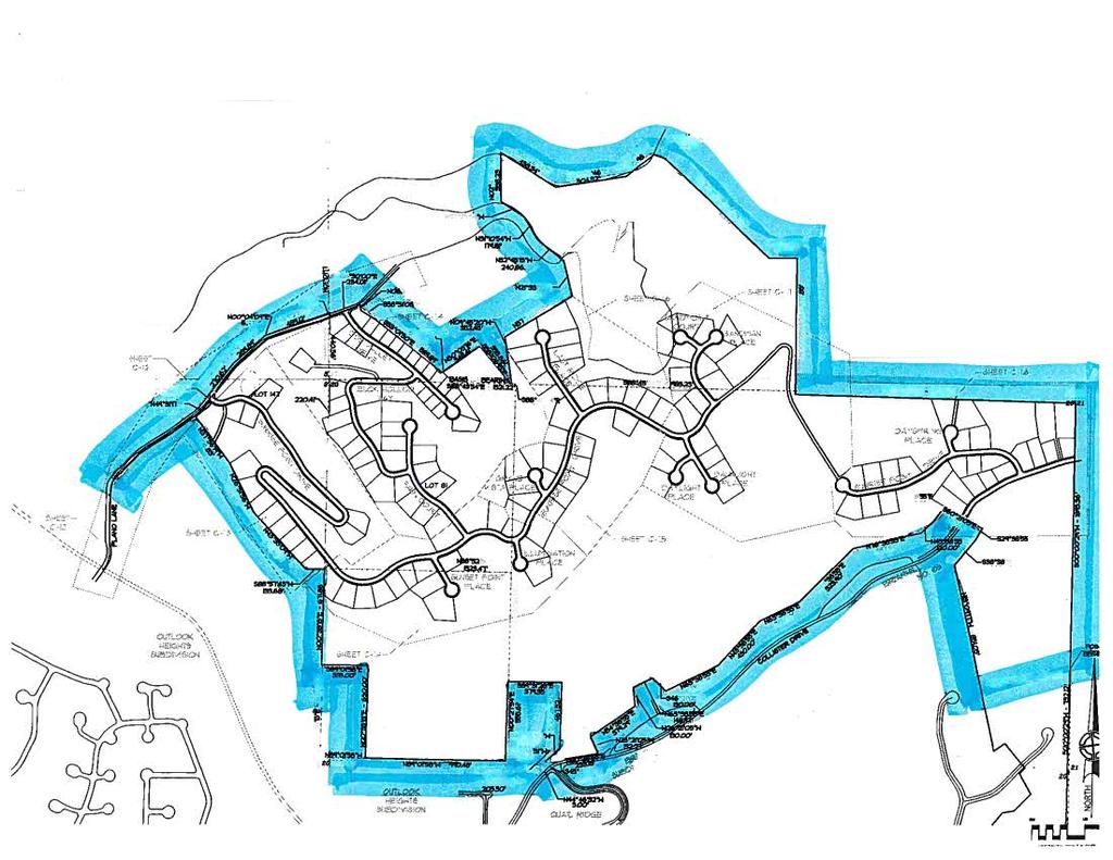
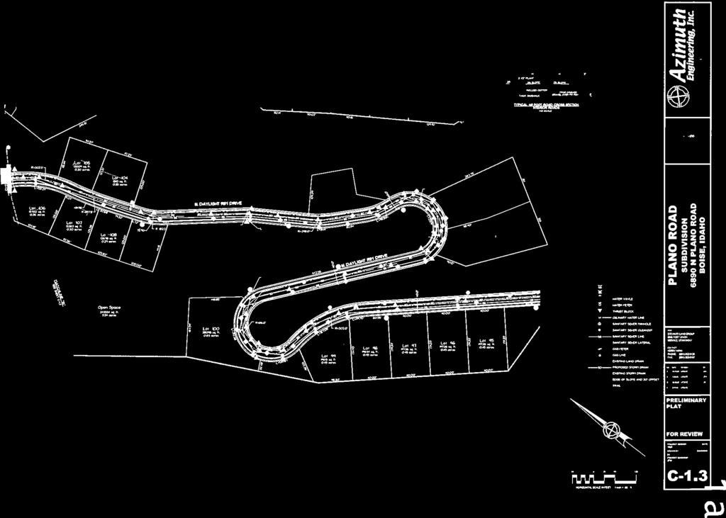
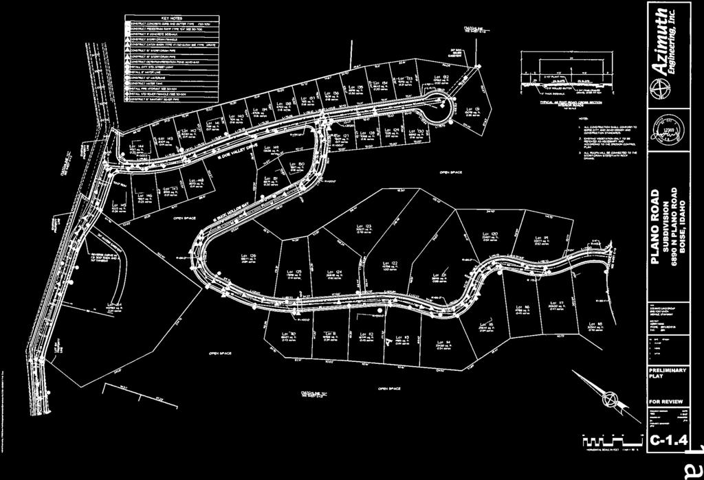
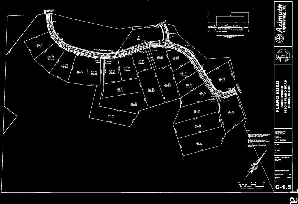
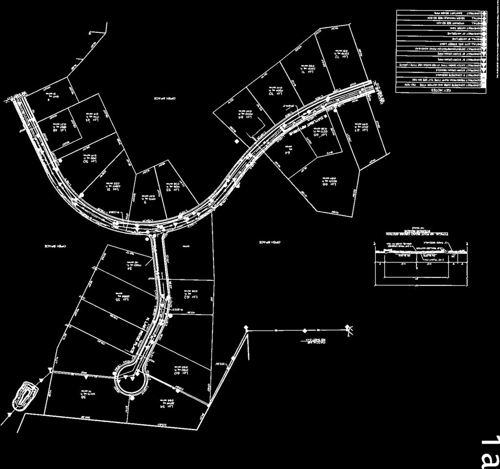
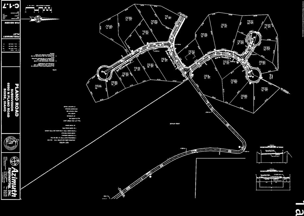
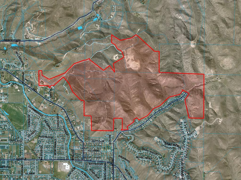
1 Subdivision Staff Report Subdivision Name Plano Road Subdivision File Number SUB Approval Preliminary Plat Lead Agency Boise City Annexation Date Pending (CAR /DA) Comp. Plan Does Not Comply Public Hearing Date December 9, 2008 Heard by Planning and Zoning Commission Planning and Zoning Commission Denial August 11, 2008 Analyst Todd Tucker Description: This is a proposed residential subdivision with 155 buildable lots and eight common lots located on 323 acres. The density of the proposed subdivision is 2.08 lots per acre. The subject property is currently located in Ada County. The subdivision is subject to approval of an associated Annexation and Rezone to R-1A/DA and A-1A/DA (CAR ), Conditional Use Permit (CUP ) and a Hillside Development Permit Application (CFH ). Location: The subject property is located north of W. Hill Road between N. Plano Lane and N. Collister Drive. Traffic: This development is estimated to generate 1,530 additional vehicle trips per day (VTD) based on the submitted traffic impact study.
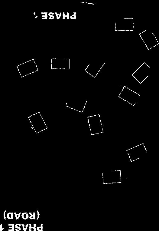
2 Page 2 of 23 Roadway Frontage Functional Level of Speed Traffic Count Classification Service* Limit Plano Road 495 Local 105 ADT north of Hill 20 N/A 4/3-4/8/2008 MPH Hill Road None Minor Arterial 7,584 west of Collister Better 35 10/23/2007 than C MPH Hill Road None Minor Arterial 4,437 west of Pierce Better 35 Park 10/23/2007 than C MPH Pierce Park 4,013 north of Castle Better 35 None Collector Lane 10/23/2007 than C MPH Pierce Park 6,182 south of Castle Better 35 None Collector Lane 10/23/2007 than C MPH Collister Road None Collector 1,764 north of Outlook Better 25 11/15/2007 than C MPH Collister Road None Collector 2,806 south of Hill Better 30 10/23/2007 than C MPH State Street None Principal 40,285 east of Collister 35 F Arterial 4/2/2008 MPH State Street None Principal 40,386 west of Pierce 45 F Arterial Park 4/2/2008 MPH *Acceptable level of service for a two-lane minor arterial roadway is D (14,000 VTD). *Acceptable level of service for a two-lane collector roadway is D (9,500 VTD). *Acceptable level of service for a five-lane principal arterial is E (37,000 VTD). Contents: Basis for Recommendation Vicinity Map Preliminary Plat Aerial Map Technical Review and Agency Comments
3 Page 3 of 23 Basis for Denial This application has been reviewed for consistency with the design standards, goals and policies of the Boise City Subdivision Ordinance and Comprehensive Plan. Standards of Review Section DESIGN STANDARDS The following standards shall be complied with, in all subdividing within the scope of these regulations. A. GENERAL In order that the subdivision of land within the jurisdiction of the City will contribute to the development of safe, convenient and attractive residential, commercial and other area and advance the public welfare, the Commission and Council in reviewing and action upon any subdivision plat shall insure that full consideration and weight is given to the following: 1. The intent and design of the proposed plat shall be in accordance with the provisions of the Boise City Comprehensive Plan. Planning and Zoning Commission Recommendation The Commission recommends denial of the subdivision. Reasons for the Decision Recommendation is based on the Boise City Planning and Zoning Commission s recommendation of denial of Plano Road Subdivision (SUB ), and denial of the Conditional Use Permit (CUP ) and Hillside and Foothill Development Permit (CFH ). The Commission finds that these applications are not in compliance with the requirements of the Boise City Zoning Ordinance and goals, objectives and policies of the Boise City Comprehensive Plan. The Commission recommended approval of the associated Annexation / Rezone to A-2/DA with Development Agreement (CAR /DA). Conditions in Dispute Applicant is appealing the recommendation of approval of annexation/rezone to A-2/DA with Development Agreement (CAR /DA) and denial of the associated Conditional Use Permit (CUP ) and Hillside and Foothill Development Permit (CFH ).
4


5


6


7
8


9


10

11


12
13
14 Page 4 of 23 Technical Review and Agency Comments Boise City Planning and Development Services: Subdivision Section Todd Tucker Prior to signature of the Final Plat by the City Engineer, the property shall be annexed into the City of Boise and rezoned in compliance with all the conditions of approval for CAR Compliance with all conditions of approval for the companion Conditional Use Permit (CUP ) is required. Compliance with all conditions of approval for the companion Hillside Development Permit (CFH ) is required. Comprehensive Planning and Zoning Section Bruce Eggleston See Staff Reports for (CAR , CUP and CFH ). Building Section Marlene Southard No comment. Sediment and Erosion Control Steve Webb An erosion and sediment control plan (ESC) conforming to the requirements B.C.C. Title 8 Chapter 17 is to be submitted to the Director of Planning and Development Services for review. No grading or earth disturbing activities may start until approval of the ESC plan has been received and an ESC permit issued. An individual who has attended the Boise City Responsible Person (RP) certification class, or has obtained Interim Certification for Responsible Person is not identified for this project. A permit will not issue until such time as the name and certification number of the RP has been provided to Boise City. Boise City Public Works: Drainage/Engineering Rob Bousfield Standard drainage conditions. Pressure Irrigation Kent Johnson A Pressure Irrigation Waiver has been granted. Sewer John Johnson Standard sewer conditons. Street Lights Henry Alarcon
15 Page 5 of 23 Standard street light conditions. 54 new street lights are required. Hillside Terry Records Standard hillside conditions. Boise City Fire Department Mark Senteno The Boise Fire Department has reviewed and can approve the application subject to compliance with the following code requirements and conditions of approval. Any deviation from this plan is subject to Fire Department approval. Please note that unless stated otherwise this memo represents requirements of the International Fire Code as adopted and amended by Ordinance Code Requirement: Fire Department vehicular access shall be provided to within 150' of all portions of the non-sprinklered buildings. Any dead-end road in excess of 150 needs a Fire Department approved turnaround. Single access roads are prohibited from exceeding 750 feet without special approval. These distances can be increased somewhat for sprinklered buildings but exact distances are on a case-by-case basis. All Fire Department access roads, fire lanes, bridges, and gates are to be a minimum of 20' wide with 13' 6" overhead clearance, shall be capable of supporting 70,000 lbs GVW (24,000 lbs per axle), and shall be paved. Fire Department access roads and fire lanes shall have a minimum outside turning radius of 48' with an inside radius of 28'. Aerial fire apparatus roads shall have a minimum unobstructed width of 26 feet in the immediate vicinity of any building or portion of building more than 30 feet in height, and at least one of the required access routes meeting this conditions shall be located within a minimum of 15 feet and a maximum of 30 feet from the building, and shall be positioned parallel to one entire side of the building. No grade may exceed 10% (please note that fire apparatus are designed for a maximum 6% grade). Width and turning radius measurements specified by this paragraph can include those surfaces vehicles generally drive upon. Specifically, gutter and rolled curb are generally considered usable, while vertical curb or sidewalks are not. Condition of Approval: All code requirements will apply. Code Requirement: For streets having a width less than 36 feet back of curb to back of curb parking shall be restricted on (1) one side; for streets having a width less than 29 feet back of curb to back of curb parking shall be restricted on both sides; and for standard ACHD cul-de-sacs parking shall be restricted on both sides. A note on the face of the final plat is required noting the parking restriction prior to signing of the final plat by the Boise City Engineer. In addition, No Parking signs shall be installed in accordance with the requirements of the IFC.
16 Page 6 of 23 Condition of Approval: All code requirements will apply. Code Requirement: Fire hydrant number and distribution is dependant on the International Fire Code Appendix C, Table C Comments: No fire hydrants have been noted. In the absence of information on existing hydrants it appears that many new hydrants may/will be needed. However, we reserve the right to modify requirements as more information comes to light. Variables affecting hydrant numbers and location include, but are not limited to, area, construction type, existing hydrants, accuracy of information provided in the application, strategic location for fire fighting forces, and required fire flow. New hydrants must be "non-private" installations. Condition of Approval: Meet IFC Appendix C, Table C105.1 for hydrant number and spacing requirements. General Requirement: Fire Department required fire hydrants, access, and street identification shall be installed prior to construction or storage of combustible materials on site. Provisions may be made for temporary access and identification measures. Specific building construction requirements of the International Building Code, International Fire Code, and Boise City Code will apply. However, these provisions are best addressed by a licensed Architect at building permit application. Boise City Parks Department Cheyne Weston No comments received. Ada County Highway District Matt Edmond, April 23, 2008 A. Findings of Fact Existing Conditions 1. Site Information: The site is currently consists of one home and vacant property. 2. Description of Adjacent Surrounding Area: Direction Land Use Zoning North Vacant / Open Space RP South Single-family residential / Open Space R-1A/R-1B/R6/R2/A-1 East Vacant / Open Space RP
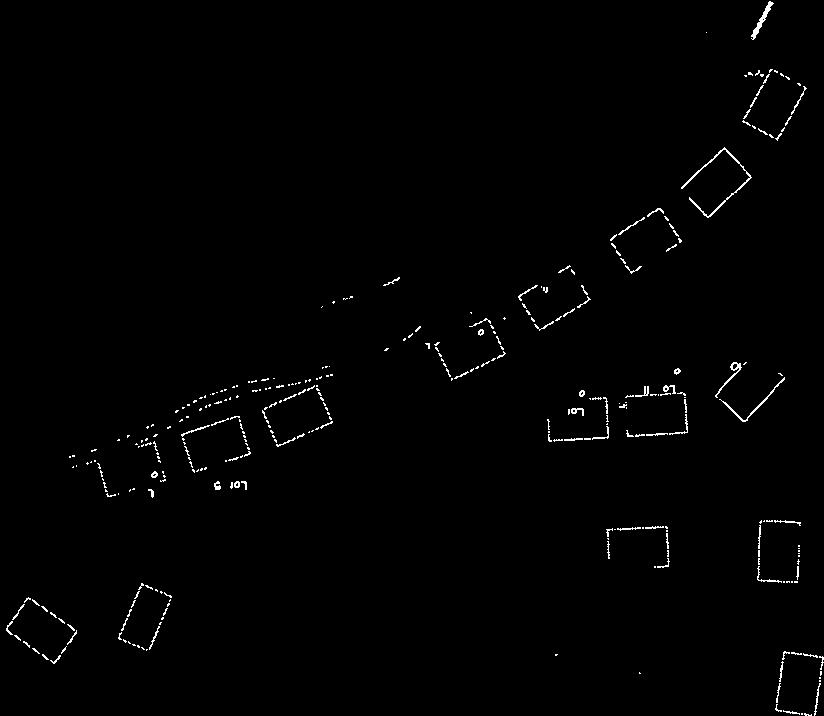
17 Page 7 of 23 West Vacant / Open Space RP 3. Existing Roadway Improvements and Right-of-Way Adjacent To and Near the Site: Plano Lane is currently improved with approximately 19-feet of pavement with no curb, gutter, or sidewalk inside 50-feet of right-of-way for approximately 750-feet north of Hill Road. A dirt road runs from the current end of the public right-of-way for Plano Lane approximately 800-feet to the site, and continues along the site s northwest boundary and provides access to four houses adjacent to or beyond the site. Collister Drive is currently improved as a 36-foot street section (back-of-curb to back-of-curb) with sidewalk on one side, all within 50-feet of right-of-way in the vicinity of the site. Hill Road is currently improved to approximately 32-feet of pavement with 2 travel lanes and bike lanes, and no curb, gutter, or sidewalk, all within 60-feet of right-ofway in the vicinity of the site. Pierce Park Lane is currently improved with 2 travel lanes, and no curb, gutter or sidewalk, all within 58-feet of right-of-way in the vicinity of the site. 4. Existing Access: There is one defined access point to this property located off of Plano Road. 5. Site History: ACHD has not previously reviewed this site for a development application. Development Impacts 6. Trip Generation: This development is estimated to generate 1,530 additional vehicle trips per day (VTD) based on the submitted traffic impact study. 7. Impact Fees: There will be an impact fee that is assessed and due prior to issuance of any building permits. The assessed impact fee will be based on the impact fee ordinance that is in effect at that time. 8. Existing Condition of Area Roadways:
18 Page 8 of 23 Roadway Frontage Functional Level of Speed Traffic Count Classification Service* Limit Plano Road 495 Local 105 ADT north of Hill 20 N/A 4/3-4/8/2008 MPH Hill Road None Minor Arterial 7,584 west of Collister Better 35 10/23/2007 than C MPH Hill Road None Minor Arterial 4,437 west of Pierce Better 35 Park 10/23/2007 than C MPH Pierce Park 4,013 north of Castle Better 35 None Collector Lane 10/23/2007 than C MPH Pierce Park 6,182 south of Castle Better 35 None Collector Lane 10/23/2007 than C MPH Collister Road None Collector 1,764 north of Outlook Better 25 11/15/2007 than C MPH Collister Road None Collector 2,806 south of Hill Better 30 10/23/2007 than C MPH State Street None Principal 40,285 east of Collister 35 F Arterial 4/2/2008 MPH State Street None Principal 40,386 west of Pierce 45 F Arterial Park 4/2/2008 MPH *Acceptable level of service for a two-lane minor arterial roadway is D (14,000 VTD). *Acceptable level of service for a two-lane collector roadway is D (9,500 VTD). *Acceptable level of service for a five-lane principal arterial is E (37,000 VTD). 9. Capital Improvements Plan (CIP) / Five Year Work Plan (FYWP): The intersection of Hill Road and 36th Street is in preliminary development in the FYWP to have a roundabout installed. Hill Road between Castle Drive and 36th Street is listed in the CIP for corridor preservation to accommodate future widening to three lanes. The intersection of Hill Road and Pierce Park Road is listed in the CIP to be widened to three lanes on all approaches and signalized in the timeframe between 2019 and The intersection of Collister Road and State Street is listed in the CIP to be widened to three lanes on the north approach in the timeframe between 2019 and State Street between Glenwood and 27th Street is listed in the CIP for corridor preservation to accommodate future widening to seven lanes. B. Findings for Consideration 1. Traffic Impact Study Dobie Engineering prepared a traffic impact study for the proposed Plano Road Subdivision. Below is an executive summary of the submitted traffic impact study as presented by Dobie Engineering.
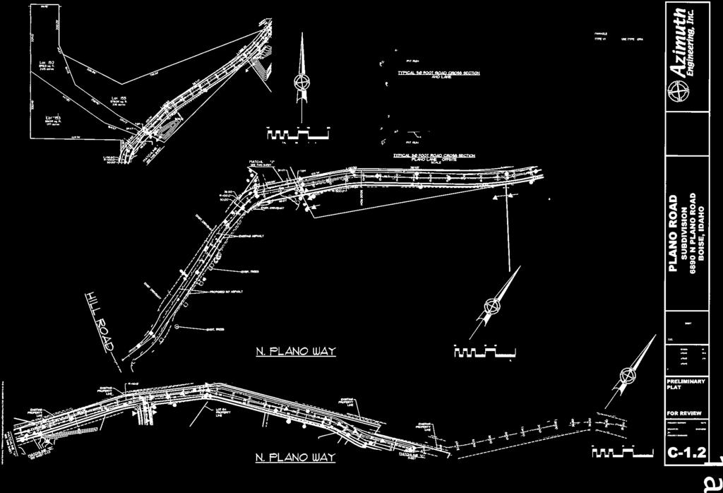
19 Page 9 of 23 The proposed Foothills Subdivision is a 268-acre residential development with 160 single family lots. The site is located north of Hill Road between Collister and Plano Road in Boise, Idaho. At full buildout the site development will produce total driveway volumes of 1,530 vehicles per day with a PM peak hour loading of 160 vehicles per hour. The proposed site plan includes two all-movement accesses to Plano Road and an extension of Collister Drive to access the site. The arterial intersections of Hill Road with both Collister Drive and Pierce Park Lane now operate with little traffic congestion (LOS B/C) and ADT volumes are within acceptable lane capacities. Lane modifications and intersection improvements on Hill Road are included in the ACHD CIP. Hill Road will require a 3-lane section at the Castle Drive intersection to accommodate regional traffic growth and site traffic from the Foothills Subdivision by The Hill Road intersection with Collister Drive will exceed the capacity of all-way stop control operation by Intersection improvements including left-turn lanes and changing the operation of the intersection from all-way to two-way stop control will be needed to accommodate regional traffic growth as identified in the COMPASS Long Range Transportation Plan. Site generated traffic can be accommodated with the additional system improvements currently included in the ACHD CIP. Total projected traffic on Plano Road will not generate sufficient turning movements to warrant auxiliary turn lanes on Hill Road. Because all internal subdivision roads will carry less than 1,000 vpd, a standard 29- foot wide 2-lane ACHD street section will be sufficient. Plano Road between Hill Road and the site access will be improved to a standard ACHD street section. Staff Comment/Recommendation: Staff Comments are provided by District Traffic Services staff. Based on the TIS assumptions, the Collister Drive Hill Road intersection will be at LOS E (35-50 seconds of delay per vehicle) in There is inadequate site distance to change the Collister Drive Hill Road intersection from all-way stop control to 2-way stop control on the Collister legs. There is currently inadequate right-of-way at the Collister Drive Hill Road intersection to add turn lanes. Installation of a traffic signal and widening the Hill Road approaches for left turn lanes at the Collister Drive Hill Road intersection would accommodate foreseeable capacity needs and safety concerns. The developer should be required improve the intersection of Collister Drive Hill Road to widen the Hill Road approaches to 3 lanes and signalize the intersection. 2. Plano Lane (Existing)
20 Page 10 of 23 Offsite Roadway Improvement Policy: District policy states that if the development is served by a public road less than 24-feet wide, the developer shall widen the pavement to a minimum of 24-feet wide, the developer shall widen the pavement to a minimum of 24-feet or add 3-feet of additional pavement to the existing road, which ever is greater. Applicant s Proposal: The applicant has proposed to extend Plano Lane from its current terminus to the site as a 30-foot pavement section with 2-foot shoulders. Staff Comment/Recommendation: District staff recommends a modification of policy to require the applicant to widen the existing portion of Plano Lane to 40-feet of pavement for 50 feet north of Hill road, and thereafter to 30 feet of pavement with a 4- foot striped bike and pedestrian lane on the east side and 3-foot gravel shoulders on both sides from Hill Road to the current extent of right-of-way. Requiring this section with a bike and pedestrian strip and gravel shoulders in lieu of sidewalk will have less of an impact on the existing homes fronting on Plano Road while allowing adequate pavement width for vehicles and pedestrians. Assuming and equal share of traffic between Plano Lane and Collister Drive with a full public street connection between the two, Plano Lane north of Hill Road will experience and estimated traffic volume increase from 105 average daily trips (ADT) to 870 ADT. 3. Plano Way Extension (Off-site) Offsite Roadway Improvement Policy: District policy states that if the development is served by a public road less than 24-feet wide, the developer shall widen the pavement to a minimum of 24-feet wide, the developer shall widen the pavement to a minimum of 24-feet or add 3-feet of additional pavement to the existing road, which ever is greater. Applicant s Proposal: The applicant has proposed to extend Plano Lane from its current terminus to the site as a 30-foot pavement section with 2-foot shoulders. Staff Comment/Recommendation: Plano Lane extends as an unaccepted and unimproved roadway for approximately 7,500-feet beyond the right-of-way currently maintained by ACHD. The applicant s proposal includes improving and dedicating a portion of this road to ACHD. However, there currently exists a gap between the current right-of-way and the site. This gap must be resolved prior to any extension of Plano Lane as ACHD right-of-way. Additionally, the City of Boise staff has expressed concern that the applicant s proposal would create a spite strip along the south/east portion of the Plano extension and deny public street frontage to parcel S Prior to any plans acceptance or scheduling of final plat for signature, the applicant should provide warranty deeds for all right-of-way to be dedicated between the existing
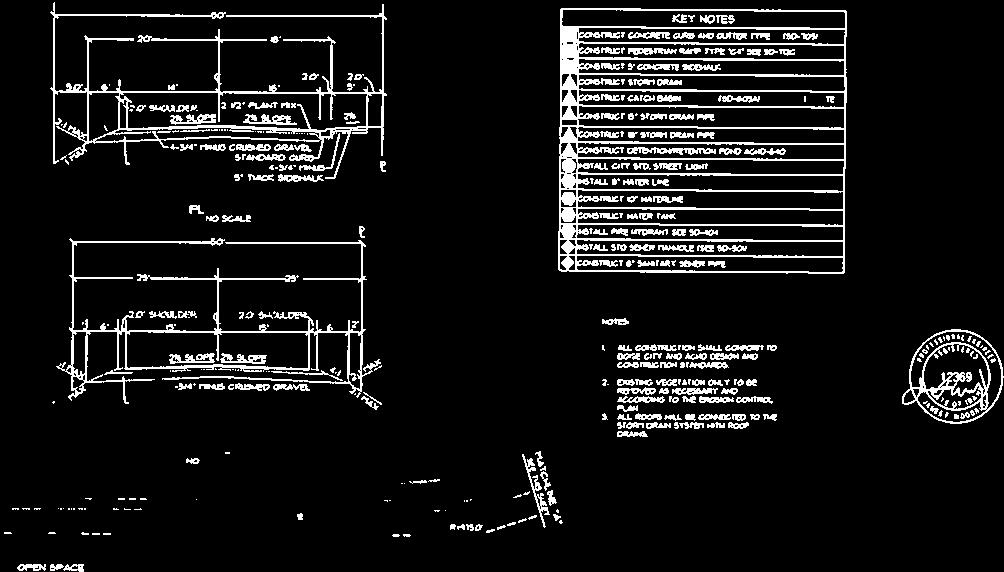
21 Page 11 of 23 right-of-way and the site, and financial surety in an amount that is acceptable to ACHD to cover the costs of improving the portion of Plano Lane between the existing right-of-way and the site. To address the concern of the city of Boise staff, the warranty deeds should provide parcel S with at least 30-feet of frontage along the new public rightof-way. District staff recommends a modification of policy to require the applicant to construct and dedicate Plano Way between the existing Plano Lane and the site as a 30-foot pavement section with a 4-foot striped bike and pedestrian lane on the east side and 3- foot gravel shoulders on both sides between the development s south property line and the portion of Plano Lane that currently exists as an ACHD roadway. Requiring this section will provide adequate width for vehicles, pedestrians and bicyclists, and match with the proposed requirement for the widening of Plano Lane to the south. 4. Plano Way (New Extension) Right-of-Way & Street Section Policy: District policy and Figure 72-F1A requires 50-feet of right-of-way on local streets. This right-of-way allows for the construction of a 2-lane roadway with curb, gutter and 5-foot attached concrete sidewalks. Curb Type: District policy requires vertical curb in areas covered by hillside ordinance, where grade is 3% or greater for more than 100-feet, or where drainage control is needed. Sidewalk Policy: District policy requires concrete sidewalk on both sides of local streets, except in rural developments with net densities of one dwelling unit per acre or less, or in hillside conditions where there is no direct lot frontage, in which case a sidewalk can be constructed on one side of the street. Applicant s Proposal: The applicant has proposed to construct Plano Way from the south property line north into the site with 30-feet of pavement, rolled curb, gutter, and 5- foot attached concrete sidewalk on the south/east side, and 2-foot gravel shoulder on the north/west side, all within 50-feet of right-of-way. Staff Comment/Recommendation: Currently, six houses and a number of vacant lots either take access to or have frontage along the unimproved and unaccepted portion of Plano Lane that extends to and beyond the site. The applicant s proposal includes improving and realigning portions of this roadway. Any improvement or realignment must accommodate both existing access requirements and the potential extension of Plano beyond the site. District staff recommends that the applicant construct and dedicate Plano Way from the south property line into the site as a 36-foot street section (back-of-curb to back-of-curb)
22 Page 12 of 23 with vertical curb and gutter on both sides and 5-foot attached concrete sidewalk on the east side. Additionally, the applicant should align and construct the Plano extension in a manner that will not preempt access to any remaining homes or vacant lots that currently take access to or have frontage along any portion of the existing unimproved roadway. 5. Collister Drive Right-of-Way & Street Section Policy: District policy and Figure 72-F1A requires 50-feet of right-of-way on local streets. This right-of-way allows for the construction of a 2-lane roadway with curb, gutter and 5-foot wide concrete sidewalks. Turnaround Policy: District policy requires turnarounds to be constructed to provide a minimum turning radius of 45-feet. Landscape and parking islands may be constructed in turnarounds if a minimum inside curb radius of 28-feet, and a minimum outside radius of 45-feet are provided. The pavement width shall be sufficient to allow the turning around of a standard AASHTO SU design vehicle without backing. Applicant s Proposal: The applicant has proposed to extend and dedicate Collister Drive from its current terminus east into the site as a 29-foot street section with rolled curb and gutter on both sides, and 5-foot attached sidewalk on one side, all within 40-feet of rightof-way. The applicant has proposed to construct a cul-de-sac turnaround at the end of Collister Drive on property currently owned by the City of Boise. The applicant has proposed to construct a parking lot which will take access off of the cul-de-sac turnaround. The proposed parking lot will act as a trail head and provide parking for those utilizing the Polecat Gulch trail system. Staff Comment/Recommendation: Collister Drive is currently classified as a collector roadway, and the presence of the Polecat Gulch Reserve access at its proposed terminus will cause additional trip generation beyond the forecast residential traffic. District staff recommends that the applicant extend and dedicate Collister Drive through the site and into the Polecat Gulch Reserve as a standard 36-foot street section with vertical curb, gutter and 5-foot concrete sidewalks on both sides, all within 50-feet of right-of-way. The 36-foot street section is consistent the street improvements on the existing section of Collister Drive and should be extended into the site. The applicant will be required to provide a minimum outside radius of 45-feet for the cul-de-sac turnaround. The applicant should coordinate with Boise City to provide a public turnaround easement covering the entire cul-de-sac. Access to any unpaved trail parking should be located at least 30-feet from the dedicated right-of-way. If the City of Boise does not grant an easement for the turnaround, the applicant should be required to dedicate additional right-of-way for the turnaround and construct it on site.
23 Page 13 of 23 Assuming an equal share of traffic between Collister Drive and Plano Lane with a full public street connection between the two, Collister Drive north of Quail Ridge Drive will experience an estimated traffic volume increase from 570 average daily trips (ADT) to 1,335 ADT. 6. Street Connectivity Traffic on One Access: District policy states that if a proposed development only has one local access to a public street, or if it proposes to extend public streets from existing development with only one local street access to the public street system, the maximum forecast ADT to be allowed at any point along the local street access is 1,000. Applicant Proposal: The applicant has proposed to take access to the public street system via Plano Lane (local) and Collister Drive (collector). The applicant has proposed to construct Daylight Rim Drive as a gravel roadway between Collister drive and Plano Lane with the first phase of development, and to restrict it for emergency and construction access only for the first four phases of development. After the first four phases, which would include 36 lots taking access on Plano and 17 lots taking access onto Collister, the applicant would construct and dedicate Daylight Rim Drive as a full public connection. Staff Comment/Recommendation: Staff previously recommended that the applicant be limited to 80 buildable lots until Daylight Rim Drive was constructed and dedicated as a full public connection between Collister Drive and Plano Lane. However, staff is supportive of the applicant s proposal to construct and dedicate Daylight Rim Drive as full public connection after Final Plat of nor more than 36 buildable lots accessing Plano Lane, or nor more than 17 buildable lots accessing Collister Drive, for no more than 53 lots total. This proposal gives a reasonable assurance that the connection will be built, and that it will be reasonably utilized at the time it is dedicated. Commission Discussion: The Commissioners expressed an interest in getting the full public connection between Plano Lane and Collister Drive completed as soon as possible, in order to provide additional ingress and egress for purposes of winter safety, fire safety, emergency services, mitigation of construction traffic, and general connectivity. The Commissioners moved to approve the applicant s proposal to construct and dedicate Daylight Rim Drive as a full public connection after final plat of nor more than 36 buildable lots accessing Plano Lane, or no more than 17 buildable lots accessing Collister Drive, for no more than 53 lots total. 7. Hill Road Collister Drive Intersection Applicant Proposal: The applicant has proposed that any improvements to the Collister Drive Hill Road intersection be made under an Extraordinary Impact Fee Agreement between ACHD and the applicant.
24 Page 14 of 23 Staff Comment/Recommendation: The Collister Drive Hill Road intersection will reach an unacceptable level of service prior to site buildout. This intersection will reach LOS E when the site is approximately half complete, with 80 homes built. District staff recommends that the applicant not build more than 80 homes on the site until such time as the Collister Drive Hill Road intersection has been improved with widening to three lanes on the Hill Road approaches and installation of a traffic signal. The applicant should have the option to either enter into a Traffic Signal Agreement with ACHD, wait until this intersection is added to the ACHD Capital Improvement Plan and enter in to a developer cooperative agreement with the District to improve the intersection, OR to wait until this intersection is improved by ACHD. If the applicant chooses to enter into a Traffic Signal Agreement, the applicant will be solely responsible for all costs except for right-of-way acquisition along Hill Road. District staff is not supportive of an Extraordinary Impact Fee Agreement to improve this intersection. To ensure that the applicant complies with one of these three options, the District will not approve a final plat of more than 80 buildable lots until such time as the prescribed improvements to the Collister Drive Hill Road intersection have been made, either by ACHD or through a Traffic Signal Agreement with the applicant. The Collister Drive Hill Road intersection is currently not listed on the CIP or the FYWP for improvement, and it is impossible to forecast if and when this intersection will be programmed for improvement by ACHD in the future. 8. Collister Drive Quail Ridge Drive Intersection The intersection of Collister and Quail Ridge Drives is a three-legged intersection that is stop-controlled on the Quail Ridge approach. The sight distance from this approach is 550-feet to the north and 210-feet to the south. While sight-distance to the south does not meet the minimum recommended distance of 280-feet for a 25 MPH approach, current accident history does not warrant any changes to this intersection at this time. Should problems arise at this intersection in the future, they can be resolved by ACHD with the installation of a three-way stop. Hill Road Plano Lane Intersection The intersection of Hill Road and Plano Lane is a three-legged intersection that is stopcontrolled on the Plano Lane approach. The sight distance from this approach is 390-feet to the west and 860-feet to the south. While these distances meet the minimum recommended sight distance of 390-feet for a 35 MPH approach, speed data indicate that a significant portion of eastbound traffic on Hill Road is traveling at 40 MPH. Due to the increased volume of traffic onto Hill Road from Plano Lane that this development will cause, District staff recommends that the applicant be required to install intersection advisory signs on the eastbound approach of Hill Road to the west of the intersection.
25 Page 15 of 23 Commission Discussion: The Commission expressed a concern over the potential hazard at the Plano Hill intersection due to increased traffic from the proposed development and the limited sight distance to the west. The Commission directed Traffic Services staff to examine the intersection and develop a proposal for traffic hazard mitigation. 9. Internal Streets Reduced Street Section: District policy and Figure 72-F1A allow a developer to construct a local urban residential street with a reduced width of 29-feet from back-ofcurb to back-of-curb with curb, gutter and sidewalk, all within 42-feet of right-of-way. Policy requires Fire Department approval from use of reduced street sections and restricts parking on reduced street sections. Sidewalk Policy: District policy requires concrete sidewalk on both sides of local streets, except in rural developments with net densities of one dwelling unit per acre or less, or in hillside conditions where there is no direct lot frontage, in which case a sidewalk can be constructed on one side of the street. Grading Policy: District policy limits the maximum allowable grade for any public street to 10%. Curve Policy: District policies and require a minimum centerline radius of 100-feet for all mid-block curves and a minimum tangent length between reverse curves of 50-feet on local streets. Turnaround Policy: District policy requires turnarounds to be constructed to provide a minimum turning radius of 45-feet. Landscape and parking islands may be constructed in turnarounds if a minimum inside curb radius of 28-feet, and a minimum outside radius of 45-feet are provided. The pavement width shall be sufficient to allow the turning around of a standard AASHTO SU design vehicle without backing. Applicant s Proposal: The applicant has proposed to construct and dedicate the internal streets as a 29-foot street sections with rolled curb and gutter on both sides, and 5-foot attached sidewalk on one side, all within 40-feet of right-of-way. The applicant has proposed to construct 6 cul-de-sac turnarounds without center landscape islands. Staff Comment/Recommendation: The topography of the site presents a challenge in ensuring compliance with District policy for local street design. The applicant s current plans propose five curves with centerline radii less than 100-feet (two on Daylight Rim Drive, three on Dawnbreak Place), and one set of reverse curves with a tangent length of less than 50-feet between them (on Daylight Rim Drive). The applicant will likely also need a variance for a centerline curve radius of less than 100-feet if it is to be a continuous public street as recommended.
26 Page 16 of 23 The applicant should construct all internal streets as 29-foot street sections (back-of-curb to back-of-curb) with vertical curb and gutter on both sides, all within 40-feet of right-ofway. Additionally, the applicant should construct continuous 5-foot concrete sidewalk on one side of all internal streets, as well as sidewalk along all lot frontages with direct access to the street. District staff recommends a modification of policy to allow the five curves with centerline radii less than 100-feet, the one centerline tangent length between reverse curves of less than 50-feet, provided all internal roadways meet AASHTO standards for a 20 MPH design speed. District staff recommends against any modification of policy to allow any centerline grade in excess of 10%. 10. Stub Streets Stub Street Policy: District policy states that the street design in a proposed development shall cause no undue hardship to adjoining property. An adequate and convenient access to adjoining property for use in future development may be required. If a street ends at the development boundary, it shall meet the requirements of sub section 7205, non-continuous streets. District policy states that stub streets will be required to provide intra-neighborhood circulation or to provide access to adjoining properties. Stub streets will conform with the requirements described in Section , and , except a temporary cul-de-sac will not be required if the stub street has a length no greater than 150-feet. A sign shall be installed at the terminus of the stub street stating that, "THIS ROAD WILL BE EXTENDED IN THE FUTURE. Turnaround Policy: District policy requires construction of a temporary cul-desac with the same dimensional requirements as a standard cul-de-sac, with a minimum turning radius of 45-feet. The pavement width shall be sufficient to allow the turning around of a standard AASHTO SU design vehicle without backing. Applicant Proposal: The applicant has proposed to construct one stub street to the north and one stub street to the east. The stub streets are proposed to be located as follows: Plano Way will approximate the alignment of the unimproved roadway that currently exists, and stub along the site s northwest boundary. Collister Drive will stub to the east, into Boise City s Polecat Gulch Reserve, and terminate in a minimum 45-foot radius paved cul-de-sac on Boise City property. Staff Comment/Recommendation: The applicant should provide a temporary turnaround at the terminus of Plano Way. The applicant should construct the cul-de-sac at the terminus of Collister Drive in the Polecat Gulch Reserve as proposed, with vertical curb, gutter, and sidewalk along its perimeter, and coordinate with the City of Boise to provide a public turnaround easement and to determine the location of driveways providing
27 Page 17 of 23 access the Polecat Gulch Reserve trailhead. If the City of Boise does not grant an easement for the turnaround, the applicant should be required to dedicate additional rightof-way for the turnaround and construct it on site. 11. Roadway Offsets Roadway Offset Policy: District policy , requires local roadways to align or offset a minimum of 125-feet from another local roadway (measured centerline to centerline). Applicant Proposal: The applicant has proposed a street layout wherein all local street intersections offset each other by a minimum of 200-feet. Staff Comment/Recommendation: The applicant s proposal for roadway offsets meets District policy and should be approved with this application. 12. Driveways Driveway Location Policy: District policy 72-F4 (1) and 72-F4 (2), requires driveways located on local residential roadways to offset a controlled and/or uncontrolled intersection a minimum of 50-feet (measured near edge to near edge). Driveway Paving Policy: Graveled driveways abutting public streets create maintenance problems due to gravel being tracked onto the roadway. In accordance with District policy, , the applicant should be required to pave the driveway its full width and at least 30-feet into the site beyond the edge of pavement of the roadway and install pavement tapers with 15-foot radii abutting the existing roadway edge. Driveway Width Policy: District Policy restricts residential driveways to a maximum width of 20-feet. Applicant s Proposal: The applicant has proposed to construct several common/shared driveways throughout the development to provide access to residential lots. All of the common/share driveways are proposed to intersect local public streets. Staff Comment/Recommendation: The applicant should ensure that all driveways onto public streets offset the nearest intersection by a minimum of 50-feet, are no wider than 20-feet, and are paved their full width and at least 30-feet into the site beyond the edge of pavement of the roadway. The applicant should coordinate with Boise City Planning and Fire Department to ensure that driveways meet city requirements for shared use and turnarounds, if required. C. Site Specific Conditions of Approval 1. Dedicate 50-feet of right-of-way for the extension of Plano Lane from the existing accepted public right-of-way to the site by execution of warranty deed prior to plans acceptance and prior to scheduling of final plat signature. The warranty deeds shall
28 Page 18 of 23 provide parcel S with at least 30-feet of frontage along the new public rightof-way. Allow up to 30 business days to process the right-of-way dedication after receipt of all requested material. 2. At the time of execution of warranty deed for Plano Lane right-of-way, provide a financial surety in an amount to be determined by ACHD and in a form acceptable to ACHD for the cost of improving Plano Way from the existing roadway to the site. 3. Improve and widen the first 50 feet of Plano Lane north of Hill Road to 40 feet of pavement. Relocated items within the right-of-way as necessary to accommodate the pavement widening and reduce sight distance obstructions as the Plano Hill intersection. 4. Improve and widen the remainder of Plano Lane to include 30 feet of pavement with a 4 foot striped bike and pedestrian lane on the east side and 3 foot gravel shoulders on both sides from Hill Road to where Plano Lane enters the site. 5. Construct and dedicate Plano Way as it extends into the site as a 36-foot street section with vertical curb and gutter on both sides, and 5-foot concrete sidewalk on the east side. 6. Ensure continued access of existing homes onto the improved portion of Plano Way. Provide curb cuts and easements as necessary. 7. Extend and dedicate Collister Drive from its current terminus to the Polecat Gulch Reserve as a 36-foot street section with vertical curb, gutter, and 5-foot concrete sidewalk on both sides, all within 50-feet of right-of-way. 8. Construct a paved cul-de-sac turnaround at Collister Drive s new terminus in the Polecat Gulch Reserve, with a minimum 45-foot outside turn radius and vertical curb, gutter, and sidewalk along its perimeter. 9. Coordinate with Boise City to provide a public turnaround easement over the cul-de-sac at Collister Drive s terminus. If the City of Boise does not grant an easement for the turnaround, the applicant shall dedicate additional right-of-way for the turnaround and construct it on site. 10. Coordinate with Boise City to determine the location of driveways providing access the Polecat Gulch Reserve trailhead. 11. Coordinate with Boise City to locate any access from the Collister Drive cul-de-sac to any unimproved parking areas a minimum of 30-feet from the dedicated right-of-way.
29 Page 19 of Construct Daylight Rim Drive as a gravel roadway connecting Plano Lane and Collister Drive, to be used for emergency and construction access only, with the first phase of the development prior to scheduling signature of the first final plat. 13. Construct and dedicate Daylight Rim Drive as a public roadway connecting Plano Lane and Collister Drive prior to schedulihg final plat of more than 36 buildable lots accessing Plano Lane, or more than Do not schedule a final plat of more than 80 buildable lots for signature by the ACHD Commission until such time as the Collister Drive Hill Road intersection is improved with three lanes on all approaches and a traffic signal. The applicant/developer may accomplish this by any of the following: a. Enter into a Traffic Signal Agreement with ACHD to improve the Collister Drive Hill Road intersection, to include widening of the Hill Road approaches to three lanes and installation of a traffic signal, prior to scheduling a Final Plat of more than 80 buildable lots. b. Wait until the Collister Drive Hill Road intersection is added to the ACHD Capital Improvement Plan for widening and signalization, and enter into a developer cooperative agreement with the District to improve the intersection. The intersection shall be fully improved prior to scheduling final a final plat of more than 80 buildable lots. There is no guarantee that this intersection improvement will ever be added to the Capital Improvement Plan. c. Wait until the Collister Drive Hill Road intersection is improved by ACHD prior to scheduling a final plat of more than 80 buildable lots. There is no guarantee that this intersection will ever be improved by ACHD. 15. Install intersection advisory signs on the eastbound approach of Hill Road west of the Hill Road Plano Lane intersection. 16. Construct and dedicate all internal streets as 29-foot street sections (back-of-curb to backof-curb) with vertical curb and gutter on both sides, and continuous 5-foot concrete sidewalk on one side, all within 40-feet of right-of-way. 17. Ensure that all street geometries comply with District policies through , except where a modification of policy has been granted. Modification of policy has been granted for only the following: a. Centerline radius of 86-feet at Sta to of Daylight Rim Drive. b. Centerline radius of 86-feet at Sta to of Daylight Rim Drive. c. Centerline radius of 86-feet at Sta to of Buck Hollow Way. d. Centerline radius of 86-feet at Sta to of Buck Hollow Way.
30 Page 20 of 23 e. Centerline radius of 86-feet at Sta to of Buck Hollow Way. f. Centerline tangent length between curves of less than 50-feet at Sta of Daylight Rim Drive. 18. Construct a temporary paved turnaround at the improved terminus of Plano Way with a minimum 45-foot outside turn radius. 19. Site all residential driveways a minimum of 50-feet from the nearest street intersection. 20. Construct all residential driveways no wider than 20-feet, and paved their full widths for a minimum of 30-feet in from the roadway edge. 21. Comply with all Standard Conditions of Approval. D. Standard Conditions of Approval 1. Any existing irrigation facilities shall be relocated outside of the right-of-way. 2. Private sewer or water systems are prohibited from being located within any ACHD roadway or right-of-way. 3. All utility relocation costs associated with improving street frontages abutting the site shall be borne by the developer. 4. Replace any existing damaged curb, gutter and sidewalk and any that may be damaged during the construction of the proposed development. Contact Construction Services at (with file number) for details. 5. Comply with the District s Tree Planter Width Interim Policy. 6. Utility street cuts in pavement less than five years old are not allowed unless approved in writing by the District. Contact the District s Utility Coordinator at (with file numbers) for details. 7. All design and construction shall be in accordance with the Ada County Highway District Policy Manual, ISPWC Standards and approved supplements, Construction Services procedures and all applicable ACHD Ordinances unless specifically waived herein. An engineer registered in the State of Idaho shall prepare and certify all improvement plans. 8. The applicant shall submit revised plans for staff approval, prior to issuance of building permit (or other required permits), which incorporates any required design changes. 9. Construction, use and property development shall be in conformance with all applicable requirements of the Ada County Highway District prior to District approval for occupancy.
31 Page 21 of Payment of applicable road impact fees is required prior to building construction. The assessed impact fee will be based on the impact fee ordinance that is in effect at that time. 11. It is the responsibility of the applicant to verify all existing utilities within the right-ofway. The applicant at no cost to ACHD shall repair existing utilities damaged by the applicant. The applicant shall be required to call DIGLINE ( ) at least two full business days prior to breaking ground within ACHD right-of-way. The applicant shall contact ACHD Traffic Operations in the event any ACHD conduits (spare or filled) are compromised during any phase of construction. 12. No change in the terms and conditions of this approval shall be valid unless they are in writing and signed by the applicant or the applicant s authorized representative and an authorized representative of the Ada County Highway District. The burden shall be upon the applicant to obtain written confirmation of any change from the Ada County Highway District. 13. Any change by the applicant in the planned use of the property which is the subject of this application, shall require the applicant to comply with all rules, regulations, ordinances, plans, or other regulatory and legal restrictions in force at the time the applicant or its successors in interest advises the Highway District of its intent to change the planned use of the subject property unless a waiver/variance of said requirements or other legal relief is granted pursuant to the law in effect at the time the change in use is sought. E. Conclusions of Law 1. The proposed site plan is approved, if all of the Site Specific and Standard Conditions of Approval are satisfied. 2. ACHD requirements are intended to assure that the proposed use/development will not place an undue burden on the existing vehicular transportation system within the vicinity impacted by the proposed development. Ada County Street Name Committee The following existing street names shall appear on the plat: W. Hill Road N. Collister Drive N. Plano Way The following proposed street names are approved: N. Buck Hollow Way N. Dayspring Lane N. Plano Lane N. Sandpoint Court
32 Page 22 of 23 N. Plano Way N. Dawnlight Place N. Last Ridge Place N. Sandman Place N. Sandman Way W. Doe Valley Court W. Daylight Rim Drive W. Doe Valley Drive Central District Health Department Malcohm McGregor After written approval from appropriate entities is submitted, we can approve this proposal for central sewage and central water. The following plans must be submitted to and approved by the Idaho Department of Health and Welfare, Division of Environmental Quality: A. Central Sewage B. Central Water Street runoff is not to create a mosquito breeding problem. STORMWATER MANAGEMENT RECOMMENDATIONS It is recommended that storm water be pre-treated prior to discharge to the subsurface to prevent impact to ground water and surface water quality. The engineers and architects involved with the design of this project should obtain current best management practices for stormwater disposal and design a stormwater management system that is preventing groundwater and surface water degradation. Manuals that could be used for guidance are: 1) Stormwater Best Management Practices Guidebook Prepared by the Boise City Public Works Department, May ) State of Idaho Catalog of Stormwateter Best Management Practices for Idaho Cities and Counties Prepared by the Idaho Division of Environmental Quality, July Independent School District of Boise #1 Sarah Stobaugh The plans for the Plano Road Subdivision show all streets ending in cul-de-sacs, with no connectivity to other surrounding streets. In order fo furnish safe school bus turn-around locations to accommodate students living in the Subdivision, The Boise School District would like to see the cul-de-sac at the end of Sunrose Point Drive and the cul-de-sac at the end of Sandman Place both be marked with signage that says No Parking School Bus Turn Around.
BPP / SUB
 Development Services Department Project/File: Lead Agency: Site address: Millwell Place Subdivision/ BPP15-0031/ SUB15-0064 This is a preliminary plat application to allow for the development of 68 building
ACHD Board of Commissioners Stacey Yarrington, Planner III Tandem Ridge/ EPP / PP-07-16/ RZ-12-16/ CPA-01-16/ A-07-16
 Development Services Department DATE: December 14, 2016 TO: FROM: SUBJECT: ACHD Board of Commissioners Stacey Yarrington, Planner III Tandem Ridge/ EPP16-0012/ PP-07-16/ Executive Summary: This is an annexation,
Development Services Department
 Kent Goldthorpe, President Paul Woods, Vice President Rebecca W. Arnold, Commissioner Sara M. Baker, Commissioner Jim D. Hansen, Commissioner July 28, 2016 Development Services Department To: From: ACHD
 Development Services Department Project/File: Lead Agency: Site address: Fall Creek Subdivision (MPP-12-016) This is a preliminary plat application to subdivision approximately 110 acres into 296 residential
2. Caven Ridge Estates Subdivision No. 1 adds 0.54 centerline miles to the ACHD roadway system.
 Kent Goldthorpe, President Paul Woods, Vice President Rebecca W. Arnold, Commissioner Sara M. Baker, Commissioner Jim D. Hansen, Commissioner October 12, 2016 Development Services Department To: From:
 Development Services Department Project/File: Lead Agency: Site address: Applicant: Memory Ranch / KPP15-0003 / 15-02-AN / 15-01-S The applicant is requesting annexation of approximately 10 acres, rezoning
BOI / DRH S. 13 th Street Mixed use office/retail development with residential dormitory
 Jim D. Hansen, President Sara M. Baker, Vice President Rebecca W. Arnold, Commissioner Kent Goldthorpe, Commissioner Paul Woods, Commissioner October 21, 2015 To: Rick Nesser ISS River Partners, LLC 8312
Development Services Department
 Kent Goldthorpe, President Paul Woods, Vice President Rebecca W. Arnold, Commissioner Sara M. Baker, Commissioner Jim D. Hansen, Commissioner July 21, 2016 Development Services Department To: From: ACHD
Committed to Service. Development Services. February 21, ACHD Commission. Mindy Wallace, AICP
 Committed to Service Sara M. Baker, President Rebecca W. Arnold, Vice President Jim D. Hansen, Commissioner Kent Goldthorpe, Commissioner Paul Woods, Commissioner February 21, 2018 Development Services
Roadway Classification Design Standards and Policies. Pueblo, Colorado November, 2004
 Roadway Classification Design Standards and Policies Pueblo, Colorado November, 2004 Table of Contents Page Chapter 1. General Provisions 1.1 Jurisdiction 3 1.2 Purpose and Intent 3 1.3 Modification 3
Committed to Service
 Development Services Department Committed to Service January 19, 2016 TO: FROM: SUBJECT: ACHD Board of Commissioners Mindy Wallace, AICP Planner III Kirsten Subdivision/BPP15-0023 Executive Summary: The
 Development Services Department Project/File: Lead Agency: Site address: Aralar Park/SUB13-00048 This is a preliminary plat application to construct 55 buildable lots and 6 common lots on 12.67 acres.
BPP / SUB /CAR /PUD
 Development Services Department Project/File: Lead Agency: Site address: Roe Street Townhomes/ BPP16-0023/ SUB16-00046/CAR16-00023/PUD16-00022 This is a rezone, preliminary plat, and planned unit development
This Chapter sets forth the minimum design, technical criteria and specifications to be used in the preparation of all roadway plans.
 4.1 GENERAL This Chapter sets forth the minimum design, technical criteria and specifications to be used in the preparation of all roadway plans. These Roadway Standards are for new construction and modification
Town of Siler City - Unified Development Ordinance ARTICLE XIV - Streets and Sidewalks
 ARTICLE XIV - Streets and Sidewalks 193 Street Classification (a) In all new subdivisions, streets that are dedicated to public use shall be classified as provided in 193(b) (1) The classification shall
Committed to Service
 Committed to Service Kent Goldthorpe, President Paul Woods, Vice President Rebecca W. Arnold, Commissioner Sara M. Baker, Commissioner Jim D. Hansen, Commissioner May 24, 2017 Development Services TO:
Committed to Service
 Committed to Service Paul Woods, President Rebecca W. Arnold, Vice President Sara M. Baker, Commissioner Jim D. Hansen, Commissioner Kent Goldthorpe, Commissioner September 19, 2017 Development Services
2. The applicant is Corey Barton Homes, Inc. and the principal for the applicant is Corey D. Barton, President.
 Kent Goldthorpe, President Paul Woods, Vice President Rebecca W. Arnold, Commissioner Sara M. Baker, Commissioner Jim D. Hansen, Commissioner February 25, 2016 Development Services Department To: ACHD
Committed to Service
 Committed to Service Sara M. Baker, President Rebecca W. Arnold, Vice President Jim D. Hansen, Commissioner Kent Goldthorpe, Commissioner Paul Woods, Commissioner February 21, 2018 Development Services
Committed to Service
 Development Services Department Committed to Service June 30, 2014 TO: FROM: SUBJECT: ACHD Board of Commissioners Christy Little Planning Review Supervisor Victory Middle School/MCUP-14-003 DATE: July
SECTION 3 STREET DESIGN
 3.01 GENERAL SECTION 3 STREET DESIGN For purposes of geometric and structural design, streets shall be classified according to the following table. The City Engineer will determine the class of all proposed
Access requests to County streets and roadways are processed through one of the following methods:
 13.1 GENERAL APPLICATION PROCESS Access requests to County streets and roadways are processed through one of the following methods: A. Planned Developments may set general locations for access points.
Street Paving and Sidewalk Policy
 City Commission Policy 600 Street Paving and Sidewalk Policy DEPARTMENT: Public Works DATE ADOPTED: June 7, 1995 DATE OF LAST REVISION: December 10, 2014 Policy No. 600.01 AUTHORITY: PASS City of Tallahassee-Leon
Committed to Service
 Development Services Department Committed to Service TO: FROM: Ada County Highway District Commissioners Mindy Wallace, AICP Planner III COMISSION HEARING: January 27, 2016 SUBJECT: Syringa Valley Specific
TOWN OF CHAPEL HILL POLICY AND PROCEDURES FOR TRAFFIC CALMING MEASURES
 TOWN OF CHAPEL HILL POLICY AND PROCEDURES FOR TRAFFIC CALMING MEASURES (Adopted by the Town Council on June 30, 2004) (Revised December 6, 2010) (Revised February 8, 2016) POLICY AND PROCEDURES FOR TRAFFIC
T A B L E OF C O N T E N T S
 T A B L E OF C O N T E N T S PART III SUBDIVISION REGULATIONS OF THE DEPARTMENT OF PUBLIC WORKS, C & C D PAGE PAGE Responsibility for Development of Streets......... 29 Right-of-Way Widths...... 37 Purpose...........
Recommended Roadway Plan Section 2 - Land Development and Roadway Access
 Recommended Roadway Plan Section 2 - Land Development and Roadway Access SECTION 2 Land Development and Roadway Access 2.1 Land Use and Access Management The Federal Highway Administration (FHWA) defines
CHAPTER 16 PEDESTRIAN FACILITIES DESIGN AND TECHNICAL CRITERIA TABLE OF CONTENTS
 CHAPTER 16 PEDESTRIAN FACILITIES DESIGN AND TECHNICAL CRITERIA TABLE OF CONTENTS Section Title Page 16.1 General... 16-1 16.1.1 AASHTO Reference... 16-1 16.1.2 ADA Requirements... 16-1 16.2 Sidewalks...
MAJOR THOROUGHFARE PLAN
 MAJOR THOROUGHFARE PLAN Adopted by City Commission On November 21, 2005 Per Resolution No. 4420 Amendment to the Comprehensive Community Development Plan City of Hobbs City of Hobbs MAJOR THOROUGHFARE
CHAPTER 4 TRANSPORTATION IMPACT STUDY TABLE OF CONTENTS
 CHAPTER 4 TRANSPORTATION IMPACT STUDY TABLE OF CONTENTS Section Title Page 4.1 Introduction... 4-1 4.1.1 General... 4-1 4.1.2 Applicant Responsibility... 4-1 4.1.3 Capacity and Safety Issues... 4-1 A.
Access Management Standards
 Access Management Standards Section 1: Application of Access Standards This chapter describes the Department's access management standards for access connections on the county roadway system. The standards
ARTICLE 24 TRANSPORTATION MANAGEMENT REGULATIONS
 ARTICLE 24 TRANSPORTATION MANAGEMENT REGULATIONS SECTION 2400 Intent To promote effective modes of transportation including safe and reasonable access between public roadways and adjacent land, transit
Access Management Regulations and Standards
 Access Management Regulations and Standards Efficient highway operation Reasonable property access Concept of Access Management The way to manage access to land development while simultaneously preserving
Driveway Design Criteria
 Design Manual Chapter 5 - Roadway Design 5L - Access Management 5L-4 Driveway Design Criteria A. General For efficient and safe operations, access drives and minor public street intersections can be improved
Staff Report Text Amendment Case #: TA
 Staff Report Text Amendment Case #: TA 2017 03 00005 Attachments: Staff Report, Current Code Planning Commission Public Hearing: Thursday, April 6, 2017 City Council Introduction: Tuesday April 11, 2017
State Street and Pierce Park Lane Intersection Concept Report
 State Street and Pierce Park Lane Intersection Prepared for September 2017 Prepared by CITATION Parametrix. 2017. State Street & Pierce Park Lane Intersection. Prepared by Parametrix, Boise, ID. September
5.0 Roadway System Plan
 Southwest Boise Transportation Study Page 16 5.0 Roadway System Plan The Roadway System Plan outlines roadway improvements in the Initial Study Area. It forecasts future deficiencies on the arterial system,
Access Management Regulations and Standards for Minor Arterials, Collectors, Local Streets
 Access Management Regulations and Standards for Minor Arterials, Collectors, Local Streets September 2009 Paul Grasewicz Access Management Administrator Concept of Access Management The way to manage access
4.0 TRAFFIC IMPACT STUDIES
 SECTION 4 4.0 TRAFFIC IMPACT STUDIES 4.1 TRAFFIC IMPACT STUDY REQUIREMENTS The City has established Traffic Impact Study (TIS) requirements for the purpose of ensuring that both the quantitative and qualitative
POLICY REVIEW SUMMARY
 E POLICY REVIEW SUMMARY The project team reviewed planning and design standards for each community in the region. The following tables summarize the relevant code in these documents that pertains to the
5.0 ROADWAY DESIGN 5.1 INTRODUCTION
 SECTION 5 5.0 ROADWAY DESIGN 5.1 INTRODUCTION In the design of roadways, it is essential to account for all the components that may affect the efficiency and safety of the roadway network. The four (4)
Villages of Pasadena Hills Financial Plan UPDATED Spring 2012 DRAFT
 36 37 38 39 40 41 42 43 44 45 46 Appendix B (Unchanged from January 2009 Adoption) 47 Projects Approved Prior to VOPH Comprehensive Plan Amendment Ashley Groves Chapel Creek Chapel Hill Farmington Hills
4APNOIPF Vh, YII PTC CITY COUNCIL AGENDA REPORT. Honorable Mayor and City Council Members. 8K TH 63 River Crossing Bridge Replacement Project
 City of RE 4APNOIPF Vh, X` W\ YII PTC ING, CITY COUNCIL AGENDA REPORT Council Meeting Date: September 26, 2016 To: From: Agenda Item: Honorable Mayor and City Council Members Ron Rosenthal, Engineering
REMOVE BARRIERS TO, ENCOURAGE CREATION OF AND PROVIDE GUIDELINES FOR SAFE ROUTES (ALL DISTRICTS)
") Ordinance 2009-98 AN ORDINANCE OF THE BOARD OF SUPERVISORS OF PIMA COUNTY, ARIZONA; RELATING TO ZONING; AMENDING THE PIMA COUNTY ZONING CODE TITLE 18 BY AMENDING SECTION 18.03.020 (DEFINITIONS) TO ADD
Ordinance 2009-98 AN ORDINANCE OF THE BOARD OF SUPERVISORS OF PIMA COUNTY, ARIZONA; RELATING TO ZONING; AMENDING THE PIMA COUNTY ZONING CODE TITLE 18 BY AMENDING SECTION 18.03.020 (DEFINITIONS) TO ADD
County of Greenville South Carolina. Traffic Calming Program Neighborhood Traffic Education Program and Speed Hump Program
 County of Greenville South Carolina Traffic Calming Program Neighborhood Traffic Education Program and Speed Hump Program (rev) August 2008 I. PURPOSE The potential negative impacts from vehicular traffic
SECTION 1 - TRAFFIC PLANNING
 SECTION 1 - TRAFFIC PLANNING 1.1 TRAFFIC OPERATIONS 1.1.1 Roadway Functional Classification The Multnomah County Comprehensive Framework Plan s Policy 34: Trafficways and the Functional Classification
Development Services Department
 Development Services Department Project/File: Lead Agency: Site address: Harris Ranch Specific Area Plan Text Amendments/ZOA14-00001 The applicant is requesting approval of a text amendment application
TRAFFIC STUDY GUIDELINES Clarksville Street Department
 TRAFFIC STUDY GUIDELINES Clarksville Street Department 9/1/2009 Introduction Traffic studies are used to help the city determine potential impacts to the operation of the surrounding roadway network. Two
Provides an extension of a road to the subdivision boundary or parcel to facilitate the continuity of possible adjacent development.
 SECTION 2 - ROADWAYS 2-1 Continuity of the Public Road System The continuity of a publicly maintained system is a prerequisite to the addition of any street into the County road system. A road or street
Frequently Asked Questions
 Frequently Asked Questions The Access Management Regulations 24 VAC 30-73 and Appendix G Design Standards Minor Arterials, Collectors, Local Streets November 2009 Land Development Section Central Office
WYDOT DESIGN GUIDES. Guide for. Non-NHS State Highways
 WYDOT DESIGN GUIDES Guide for Non-NHS State Highways 2014 GUIDE FOR Non-NATIONAL HIGHWAY SYSTEM (Non-NHS) STATE HIGHWAYS PRESERVATION REHABILITATION RECONSTRUCTION INTRODUCTION This Guide is directed to
Committed to Service
 Committed to Service Paul Woods, President Rebecca W. Arnold, Vice President Sara M. Baker, Commissioner Jim D. Hansen, Commissioner Kent Goldthorpe, Commissioner January 16, 2018 Development Services
TABLE OF CONTENTS. 1.0 INTRODUCTION AND PURPOSE Introduction Purpose Applicability.. 2
 TABLE OF CONTENTS CHAPTER & SECTION 1.0 INTRODUCTION AND PURPOSE. 1 1.1 Introduction 1 1.2 Purpose... 1 1.3 Applicability.. 2 2.0 FUNCTIONAL CLASSIFICATION AND REGULATIONS.. 2 2.1 Functional Classification....
GWINNETT COUNTY DEPARTMENT OF TRANSPORTATION
 GWINNETT COUNTY DEPARTMENT OF TRANSPORTATION 1 of 7 June 20, 2007 GENERAL: The following guidelines shall be used in the determination of the requirement for left turn lanes for development projects and
CITY OF ROSEVILLE DESIGN STANDARDS
 CITY OF ROSEVILLE DESIGN STANDARDS Section 1 Purpose and Definitions 1-1 Purpose PD 1 1-2 Design Practice PD 1 1-3 Definitions PD 1 Section 2 General Requirements 2-1 Plans by an Appropriate Engineer GR
4.11 TRANSPORTATION/CIRCULATION
 4.11 TRANSPORTATION/CIRCULATION This section was developed using information from a Traffic Analysis Report prepared for the project by OEG, Inc. (2010), the Paradiso del Mare Ocean and Inland Estates
Classification Criteria
 SCHEDULE D TO RECOMMENDED OFFICIAL PLAN AMENDMENT NO. 40 SCHEDULE C-4 Road Criteria Criteria Traffic Service Objective Land Service/Access Typical Daily Traffic Volume Flow characteristics Travel Speed
MOBILE COUNTY COMMISSION DESIGN GUIDELINES for Improving. Existing County Maintained Unpaved Local Roads
 4 t MOBILE COUNTY COMMISSION DESIGN GUIDELINES for Improving Existing County Maintained Unpaved Local Roads 2012 FORWARD The Mobile County Commission is charged, by law, with authority in relation to the
DIVISION 2200 STREETS
 DIVISION 2200 STREETS SECTION 2205 STREET DESIGN 1.01 GENERAL The purpose of these criteria is to provide uniform procedures for designing and checking the design of both public and private streets within
10.0 CURB EXTENSIONS GUIDELINE
 10.0 CURB EXTENSIONS GUIDELINE Road Engineering Design Guidelines Version 1.0 March 2017 City of Toronto, Transportation Services City of Toronto Page 0 Background In early 2014, Transportation Services
Geometric Design Tables
 Design Manual Chapter 5 - Roadway Design 5C - Geometric Design Criteria 5C-1 Geometric Design Tables A. General The following sections present two sets of design criteria tables - Preferred Roadway Elements
A5.1 Permitted activities
 Section A5 Transportation A5.1 Permitted activities A5.1.1 Activities within roads Note: Refer to Section D for the definition of road (a) Any activity associated with the movement of traffic and the functioning
MUNICIPALITY OF ANCHORAGE Traffic Department MEMORANDUM
 MUNICIPALITY OF ANCHORAGE DATE: MEMORANDUM TO: FROM: SUBJECT: Anchorage Contractors, Builders, Designers, and Land Owners Robert E. Kniefel, P.E., Municipal Traffic Engineer Municipal Driveway Standards
Access Management Regulations and Standards
 Access Management Regulations and Standards January 2014 Efficient highway operation Reasonable property access Concept of Access Management The way to manage access to land development while preserving
CHAPTER 7 STREET DESIGN AND TECHNICAL CRITERIA TABLE OF CONTENTS
 CHAPTER 7 STREET DESIGN AND TECHNICAL CRITERIA TABLE OF CONTENTS Section Title Page 7.1 General... 7-1 7.1.1 Conforming to Standards and Master Plans... 7-1 7.1.2 Construction Drawings Relating to Chapter
December 2, ACHD Board of Commissioners. Lauren Watsek Planner I. PUD (Deep Green Condominiums) Executive Summary:
 Executive Summary:") Development Services Department December 2, 2013 TO: FROM: SUBJECT: ACHD Board of Commissioners Lauren Watsek Planner I PUD13-00013 (Deep Green Condominiums) Executive Summary: The applicant is requesting
Development Services Department December 2, 2013 TO: FROM: SUBJECT: ACHD Board of Commissioners Lauren Watsek Planner I PUD13-00013 (Deep Green Condominiums) Executive Summary: The applicant is requesting
TRAFFIC IMPACT STUDY CRITERIA
 Chapter 6 - TRAFFIC IMPACT STUDY CRITERIA 6.1 GENERAL PROVISIONS 6.1.1. Purpose: The purpose of this document is to outline a standard format for preparing a traffic impact study in the City of Steamboat
Central Arkansas Regional Transportation Study Area ROADWAY DESIGN STANDARDS And Implementation Procedures
 Central Arkansas Regional Transportation Study Area ROADWAY DESIGN STANDARDS And Implementation Procedures These standards have been prepared for the use of all jurisdictions to incorporate into their
PROJECT NO. 093 MA 199 H C. FEDERAL NO. xxxx WIKIEUP-WICKENBURG-PHOENIX HIGHWAY TEGNER STREET, ALTERNATIVE 10 PROJECT IMPROVEMENT
 PROJECT NO. 093 MA 199 H 5807 01C FEDERAL NO. xxxx WIKIEUP-WICKENBURG-PHOENI HIGHWAY TEGNER STREET, ALTERNATIVE 10 PROJECT IMPROVEMENT (INTERSECTION IMPROVEMENT) US 93/US 60 FINAL PROJECT ASSESSMENT April
TOWN OF MARANA. Subdivision Street Standards Manual
 TOWN OF MARANA Subdivision Street Standards Manual May 2013 TABLE OF CONTENTS CHAPTER & SECTION 1.0 INTRODUCTION AND PURPOSE. 1 1.1 Introduction 1 1.2 Purpose... 1 1.3 Applicability.. 2 2.0 FUNCTIONAL
Clackamas County Comprehensive Plan
 ROADWAYS The County s road system permits the movement of goods and people between communities and regions, using any of a variety of modes of travel. Roads provide access to virtually all property. They
PennDOT Access Management Model Ordinances Training
 PennDOT Access s Training Trainers: Chad Dixson, AICP, TPD Angela Watson, PB Objective of Today Assist Pennsylvania s municipalities and transportation professionals in better understanding the benefits
INTER- AND INTRA-CONNECTIVITY INTERPRETIVE GUIDELINES
 INTER- AND INTRA-CONNECTIVITY INTERPRETIVE GUIDELINES Prepared by: The City of Sanibel Planning Department March 6, 2014 Introduction One of the City Councils goals adopted for the fiscal year of 2013-2014
Revisions to Larimer County Urban Area Street Standards (2016 Update)
") 1.9.2 B 1-18 Street Construction Policy 1.14 (new) 1-29 Complete Streets in Fort Collins 4.1.1 04-01 General 4.1.3 04-01 Capacity and Safety Issues 4.1.3 B 04-02 Pedestrian Traffic Considerations 4.1.4
1.9.2 B 1-18 Street Construction Policy 1.14 (new) 1-29 Complete Streets in Fort Collins 4.1.1 04-01 General 4.1.3 04-01 Capacity and Safety Issues 4.1.3 B 04-02 Pedestrian Traffic Considerations 4.1.4
APPENDIX G: INTERSECTION NEEDS AT OKEECHOBEE BOULEVARD
 APPENDIX G: INTERSECTION NEEDS AT OKEECHOBEE BOULEVARD INTERSECTION NEEDS AT SR 7 and OKEECHOBEE BOULEVARD SR 7 Extension Project Development and Environment (PD&E) Study From Okeechobee Boulevard (SR
Chapter 5 FUNCTIONAL CLASSIFICATION
 Chapter 5 FUNCTIONAL CLASSIFICATION Functional classification is a system by which streets and roadways may be distinguished by types according to their function within the entire transportation network.
Roads that are intended to be included in the VDOT system of maintained roadways must meet the standards and specifications prescribed by the VDOT.
 SECTION 1 - GENERAL 1-1 Purpose This Manual has been prepared to promote uniform design procedures for designers and technicians in the development of property and roads in the County of Henrico, Virginia.
WYDOT DESIGN GUIDES. Guide for. NHS Arterial (Non-Interstate)
") WYDOT DESIGN GUIDES Guide for NHS Arterial (Non-Interstate) 2014 GUIDE FOR NATIONAL HIGHWAY SYSTEM (NHS) HIGHWAYS (NHS ARTERIALS, Non-Interstate) PRESERVATION REHABILITATION RECONSTRUCTION INTRODUCTION
WYDOT DESIGN GUIDES Guide for NHS Arterial (Non-Interstate) 2014 GUIDE FOR NATIONAL HIGHWAY SYSTEM (NHS) HIGHWAYS (NHS ARTERIALS, Non-Interstate) PRESERVATION REHABILITATION RECONSTRUCTION INTRODUCTION
Transportation Impact Study for Abington Terrace
 Transportation Impact Study for Abington Terrace Abington Township, Montgomery County, PA Sandy A. Koza, P.E., PTOE PA PE License Number PE059911 Prepared by McMahon Associates, Inc. 425 Commerce Drive,
Citizens Handbook for Requesting Traffic Calming Devices
 Citizens Handbook for Requesting Traffic Calming Devices January 19, 2015 Table of Contents 1. PURPOSE... - 1-2. DEFINITIONS... - 2-3. GENERAL INFORMATION... - 3-3.1. ELIGIBILITY REQUIREMENTS... - 3-3.2.
STATEMENT of POLICY and PROCEDURE
 SCHEDULE B to BY-LAW NO. 96-2013 STATEMENT of POLICY and PROCEDURE No. Responsibility: Roads Date: October 21, 2013 Policy: Road Design Standards Revised: Approved by: By-law No. 96-2013 Pages: 6 Purpose:
Appendix 3 Roadway and Bike/Ped Design Standards
 Appendix 3 Roadway and Bike/Ped Design Standards OTO Transportation Plan 2040 4/20/2017 Page A3-1 Adopted Standards The adopted OTO Design Standards and Major Thoroughfare Plan are contained herein.
INTRODUCTION THOROUGHFARE SYSTEM CLASSIFICATIONS
 INTRODUCTION The thoroughfare plan will assist public officials in the development of a specialized system for efficient and safe movement of vehicular traffic while minimizing potential conflicts with
DRAFT. Corridor study. Honeysuckle Road. October Prepared for the City of Dothan, AL. Prepared by Gresham, Smith and Partners
 DRAFT Corridor study Honeysuckle Road October 2017 Prepared for the City of Dothan, AL Prepared by TABLE OF CONTENTS SECTION I... 1 STUDY SUMMARY... 1 INTRODUCTION... 1 CONCLUSIONS... 5 SECTION II... 7
Americans with Disabilities Act Transition Plan for Public Right-of-Way Improvements
 Americans with Disabilities Act Transition Plan for Public Right-of-Way Improvements Prepared by: Public Works Department Engineering Division October 2015 Table of Contents Section I Introduction.. 3
DRAFT - CITY OF MEDFORD TRANSPORTATION SYSTEM PLAN Roadway Cross-Sections
 Roadway Cross-Sections Medford s roadway cross-section standards apply to new and reconstructed roads. The crosssections take into consideration roadway function and operational characteristics, including
Considerations in the Review and Approval of a Driveway in Your Jurisdiction
 Considerations in the Review and Approval of a Driveway in Your Jurisdiction So, are you the person at your agency who reviews and approves new driveways? Or, perhaps you are part of the TEAM of people
Bradford s Landing. Preliminary Plan Abandonment AB753 & AB754 MONTGOMERY COUNTY PLANNING DEPARTMENT
 Bradford s Landing Preliminary Plan 120170060 Abandonment AB753 & AB754 1 Overview Staff recommends Approval of Preliminary Plan 120170060 with revised conditions and Adoption of the Resolution. 244 lots
APPENDIX B(1) SUBDIVISION STREET DESIGN GUIDE. SECTION B(1) 1 INTRODUCTION Introduction... B(1)-1
 SUBDIVISION STREET DESIGN GUIDE. SECTION B(1) 1 INTRODUCTION Introduction... B(1)-1") APPENDIX B(1) SUBDIVISION STREET DESIGN GUIDE SECTION B(1) 1 INTRODUCTION Introduction... B(1)-1 SECTION B(1) 2 DESIGN REQUIREMENTS Projected Traffic / Operational / Capacity Analysis... B(1)-2 Functional
APPENDIX B(1) SUBDIVISION STREET DESIGN GUIDE SECTION B(1) 1 INTRODUCTION Introduction... B(1)-1 SECTION B(1) 2 DESIGN REQUIREMENTS Projected Traffic / Operational / Capacity Analysis... B(1)-2 Functional
October 2004 REVISIONS (2) SUPERELEVATION DEVELOPMENT 11.3(2)
 SUPERELEVATION DEVELOPMENT 11.3(2)") October 2004 REVISIONS (2) Chapter 11 HORIZONTAL ALIGNMENT SUPERELEVATION DEVELOPMENT 11.3(2) Chapter 12 VERTICAL ALIGNMENT VERTICAL CURVES PASSING SIGHT DISTANCE 12.5(2) VERTICAL CURVES STOPPING SIGHT
October 2004 REVISIONS (2) Chapter 11 HORIZONTAL ALIGNMENT SUPERELEVATION DEVELOPMENT 11.3(2) Chapter 12 VERTICAL ALIGNMENT VERTICAL CURVES PASSING SIGHT DISTANCE 12.5(2) VERTICAL CURVES STOPPING SIGHT
RZC Appendix 8A Marymoor Subarea Street Requirements
 RZC Appendix 8A Marymoor Subarea Street Requirements For additional design details for Marymoor Subarea infrastructure, refer to the 2017 Marymoor Subarea Infrastructure Planning Report. STREET REQUIREMENTS
Appendix T CCMP TRAIL TRAFFIC & TRANSPORTATION DESIGN STANDARD
 Appendix T CCMP 3.3.4 TRAIL TRAFFIC & TRANSPORTATION DESIGN STANDARD 3.3.4 Trail Traffic and Transportation Design Multi-use trails have certain design standards, which vary depending on the agency that
Ordinance No ORDINANCE NUMBER 238
 Ordinance No. 238 1 ORDINANCE NUMBER 238 BY THE ADA COUNTY HIGHWAY DISTRICT BOARD OF COMMISSIONERS: SARA M. BAKER, REBECCA W. ARNOLD, JIM D. HANSEN, KENT GOLDTHORPE, PAUL WOODS AN ORDINANCE AMENDING TITLE
Introduction to Roadway Design
 Chapter Introduction to Roadway Design 1 This chapter lays the foundation for the Roadway Design course. You examine the roadway design workflow and the completed drawing files and review the project scope,
City of Norwalk Connecticut Department of Public Works
 City of Norwalk Connecticut Department of Public Works Roadway Standards May 1982 - Amended January 2017 CITY OF NORWALK, CONNECTICUT DEPARTMENT OF PUBLIC WORKS ROADWAY STANDARDS DESIGN MANUAL AND CONSTRUCTION
West Dimond Blvd Upgrade Jodhpur Street to Sand Lake Road
 West Dimond Blvd Jodhpur St to Sand Lake CSS Transportation Project Summary Municipality of Anchorage Project # 05 005 Project Manager: John Smith, P.E. (MOA PM&E) Project Administrator: Julie Makela,
Pierce County Department of Planning and Land Services Development Engineering Section
 Pierce County Department of Planning and Land Services Development Engineering Section PROJECT NAME: DATE: APPLICATION NO.: PCDE NO.: Circled items need to be addressed. Checked items are OK. A determination
General Design Factors
 Chapter 3: 3-1.0 Introduction General Design Factors Mn/DOT s goals include encouraging and accommodating safe bicycling. From a design perspective, these goals are achieved by first having an understanding
Roadway Design Manual
 Roadway Design Manual Revised December 2013 2013 by Texas Department of Transportation (512) 302-2453 all rights reserved Manual Notice 2013-1 From: Manual: Mark A. Marek, P.E Roadway Design Manual Effective
Urban Planning and Land Use
 Urban Planning and Land Use 701 North 7 th Street, Room 423 Phone: (913) 573-5750 Kansas City, Kansas 66101 Fax: (913) 573-5796 Email: planninginfo@wycokck.org www.wycokck.org/planning To: From: City Planning