APPENDIX A FINAL REPORT. Town
|
|
|
- Shanna Carr
- 5 years ago
- Views:
Transcription


1 APPENDIX A FINAL REPORT Phase Two of the Feasibility and Capacity Study Town of Oakville prepared by Engineering Limited May 2018
2
3 Harbours Master Plan: : Conceptual Marinas Phase Two of the Feasibility and Capacity Study Prepared for by SHOREPLAN ENGINEERING LIMITED VERSION DATE STATUS draftt final COMMENTS for review This report was prepared by Engineering Limited for use by the Town of Oakville. The material within reflects the judgment of based on the information available to them at the time of preparation. Any use of this report by Third Parties, including relying on decisions made because of this report, are the responsibility of the Third Parties. Engineering Limited is not responsible for any damages suffered by any Third Party as a result of decisions made, or actions based, on this report.
4 1 Introduction Report Structure Marina Design and Planning Parameters Slip Space Requirements Land Requirements Parking Winter Storage Development of Conceptual Marina Layouts Selection of Sites Conceptual Marina Layouts Methodology Conceptual Marina Layouts Approval Process and Comments on Site Selections Comments on Site Selections Launching Facilities References Appendix A Cost Estimates Table of Contents List of Figures Figure 3..1: Conceptual Marina Locations Figure 3..2: Lakeside Park Marinaa Figure 3..3: Tannery Park Marinaa Figure 3..4: Bronte Outer Harbour Marina Expansion Figure 3..5: Bronte West Marina Figure 3..6: Shell Park Marina List of Tabless Table 2.1: Slip Sizes... 2 Table 3.1: Summary of Marina Concepts... 8 Table 3.2: Summary of Parking and Winter Storage... 8 Table 3.3: Preliminary construction cost estimates for marina concepts... 9 i
5 1 Introduction Engineering Limited () was retained as part of a multidisciplinary team by the Town of Oakville to complete Phase Two of the Feasibility and Capacity Study. Phase One was the Region of Halton boating study that wass finalized in The study looked at boating demand along the north shore of Lake Ontario. The present study is a high-level the following work items: conceptual design study for a new 500-slip marina in Oakville. The work included Review of existing harbours and shoreline parks, and background information such as bathymetry, wind and wave conditions, to identify potential locations for a future marina, and, Development of conceptual marina layouts at thee identified locations, ncluding the need for dredging, protection structures, launching areas, parking facilities, and marina buildings. This report presents the work items above. 1.1 Report Structure The report is organized as follows. Chapter 2 provides a summary of planning parameters used for marina planning and design. Chapter 3 describes the site selection process for the new marinas and presents conceptual marina layouts at five locations.. Chapter 4 provides a short discussion on launch ramp planning parameters and siting. Figures are presented at the end of each chapter. Tables are located within the text, after they are first referenced. 1
6 2 Marina Design and Planning Parameters This section presents planning and design guideliness used to identify potential sites and to prepare the conceptual marina layouts presented in Section 3. The in-water space requirements are described in Section 2.1 and the land-based requirements for support facilities are describedd in Section 2.2. The requirements described are for approximately 5000 slip marina. The size of 500 slips was selected as a epresentative size of marinas along north shore of Lake Ontario. Past assessments have shown that marina operations of this size can be financially sustainable. The selection of an optimum size at each of the locations considered would be a subject of future studies. 2.1 Slip Space Requirements The in-water area for a marina includes area required for docks, fairways, breakwaters, turning and maneuvering areas. The average area required perr slip depends on the mix of slip sizes in the marina and marina layout. Table 2.1 provides a summary typical slip dimensions for common slip sizes on Lake Ontario. The double slip width is the clear width between two adjacent finger docks thatt can accommodate two boats. The internal fairway width is the clear width of the internal aisles between adjacent docks. A typical fairway width is twice the slip length, although factors less than 2 are sometimes used where space is a limiting factor. Table 2.1: Slip Sizes Boat Size 9 m 11 m 14 m 16 m 18 m Double slip width 8 m 10 m 11 m 12 m 12 m Internal Fairway Width (2x boat length) 18 m 22 m 28 m 32 m 36 m We have been involved with a number of marina projects on Lake Ontario. We looked at four marinas to determine the average area equired per boat including breakwaters, entrances, aisles, turning areas and maneuvering. The average area per slip ranged between 190 and 270 m 2 /boat. This is consistent with the ACSE (2012) guidelines which recommend allowing m 2 /boat for an average boat length of m. Forr the present study, we used an area of 250 m 2 per boat in review of potential locations for marinas in Oakville. For 500 slips, that equates to a total in-water area of approximately 125,000 m 2. The in-water area described above must be in sufficiently deep water. Providing a minimum 2 metre water depth at low water levels is typical for marinas on Lake Ontario. This water depth 2
7 can accommodate most recreational boat drafts. Thee chart datum of 74.2 m IGLD 1985 is commonly taken as low water level on Lake Ontario. Thus, the lakebed in the in-water area describedd above should be at approximately 72.2 m or lower. 2.2 Land Requirements Land is required adjacent to the marina to provide land-based support facilities for the marina operations. Basic services include: road access, parking, winter storage and a marina centre with offices, washrooms, laundry and other basic services. Additional features or servicess that may be provided include: haul-outs, boat sales, repair services, fuel sales, and onshore recreational facilities. In the development of the conceptual marinaa layouts, we have allowed for a buffer between the shorelinee protection and the land-based facilities, car parking and a marina centre. Additional facilities will increasee the area demands of the land-based facilities of the marina Parking The areaa that should be allowed for parking at the planning stage is the number of parking spaces multiplied by the area required per parking space. The number of parking spaces required to support a marina is typically given as ratio of the number of slips. Planning guidelines and regulations vary on the number of spaces per slip that should be provided. Small Craft Harbours Branch (1992) recommends 0.3 to 0. 4 spaces per slip under typical demand with 0.5 to 0.7 spaces per slip during peak periods. The Department of Fisheriess and Oceans (DFO) Canada (1985) guidelines give a planning ratio of 0.75 spaces per slip. Ross, N.W. (1989) recommends 0.5 spaces per slips. We looked at some regulations in Canada, the USA and Australia. The minimum parking ratios ranged between 0.6 and 0.8 spaces per slip. The Zoning By-Law specifies a minimum ratio of 0.6 parking spaces per berth. Consistent with the Town by-lawmarina, thatt equates to 300 parking spaces. we have used a parking ratio of 0.6 spaces per slip for this study. For a 500-slip The average area per parking space includes the parking space itself, plus an allowance for circulation aisles, landscaping and buffers. The Zoning By-Law gives a minimumm parking space dimension of 2.7 m wide by 5.7 m long. The minimum aisle width specified is 6.0 m. With efficient parking layout and minimum landscaping and buffers, the average area per space with the minimum Town dimensions could approach 30 m 2 per space. ASCE (2012) guidelines recommend a planning density of m 2 per space. For this high- level study, we have used a conservative planning density of 50 m 2 per space to allow for sufficient circulation and maneuvering areaa and some landscaping. Multiplied by 300 spaces, that gives an area of 15,000 m 2. 3
8 2.2.2 Winter Storage The areaa for winter storage is the number of boats to be stored multiplied by the area required per boat including access aisles. The areaa required per boat depends on the average boat size and packing density. calculated winter storage densities at other marinas on Lake Ontario as part of previous studies in Hamilton and Mississauga. The winter storage densities ranged between 444 m 2 per boat and 63 m 2 per boat. ACSE (2012) recommends a planningg density of 62 to 74 m 2 per boat for an average boat size of 10.7 m to 12.2 m with 6 to 8 m wide access aisles. For this study, we have assumed a winter storage density of 70 m 2 per boat. As far as we are aware, there are no guidelines or regulations for the proportion of winter storage that must be provided for a marina. Providing 100 percent winter storage is ideal, but rarely practical. The land required to provide this proportion of winter storage is not realistic unless there is an excess of land. Where space is a limiting factors, car parking areas can be used for winter storage during the winter season. In the development of alternatives, we have not included an areaa allowance for dedicated winter storage. We assumed that car parking area could be used for winter storage during the winter months. 4
9 3 Development of Conceptual Marina Layouts 3.1 Selection of Sites We studied the Oakville shoreline to determine suitable sites for a new marina. The following factors were used to determine suitable sites: Shoreline in public ownership, Ease of access, and Proximity to commercial centres. Only locations where the shoreline is in public ownership were considered. Seven locations were considered where there was a sufficiently long section of shoreline in public ownership. Coronation Park has approximately 700 m of shoreline in public ownership. We understandd that the park is well-used for mostly passive recreational activities and has natural beaches. This site was deemed to not be appropriate and excluded. Another site excluded was Carrington Promenade. Approximately 500 m of shoreline is in public ownership with residential land-use in the backshore. This site was not consideredd further as there are only narrow access ways from the municipal road to the shoreline. All feasible sites are located on the open lake with a similar level of exposure. They will be subject to typical open lake wind and wave conditions experienced on the north shore of Lake Ontario in Oakville. All sites will require the construction of breakwater structures to create a harbour and shelter the docks from waves. The marina entrance(s) ) will need to be oriented and designedd to reduce wave penetration into the harbour. Existing Lake Ontario bathymetry was also consideredd in the siting of potential marinas. As describedd in Section 2.1, deep water is desirable, with a lakebed elevation of 72.2 m typically used as the highest feasible lakebed elevation withinn marinas on Lake Ontario. Obtaining sufficiently deep water can be achieved by siting the in-water marina area beyond the existing 72.2 m contour and infilling to create a landmass out from the existing shoreline. Alternatively, dredging can be carried out during the initial construction within the marina basin. Sites where the lake bed reaches 72.2 m or below relatively close to the shoreline are desirable to reduce dredging and infilling costs. Most of the potential sites inn Oakville meeting the criteria described above would require so dredging, thus we did not eliminate sites based on this criterion. Five locations were retained for the development of conceptual marina layouts. The conceptual marina locations are identified on Figure 3.1 and are: Alternative 1 Lakeside Park Marinaa Alternative 2 Tannery Park Marina Alternative 3 Bronte Outer Harbourr Marina Expansion Alternative 4 Bronte West Marina Alternative 5 Shell Park Marina One conceptual marina layouts were developed for each of the five locations and are presented in the following section. 5
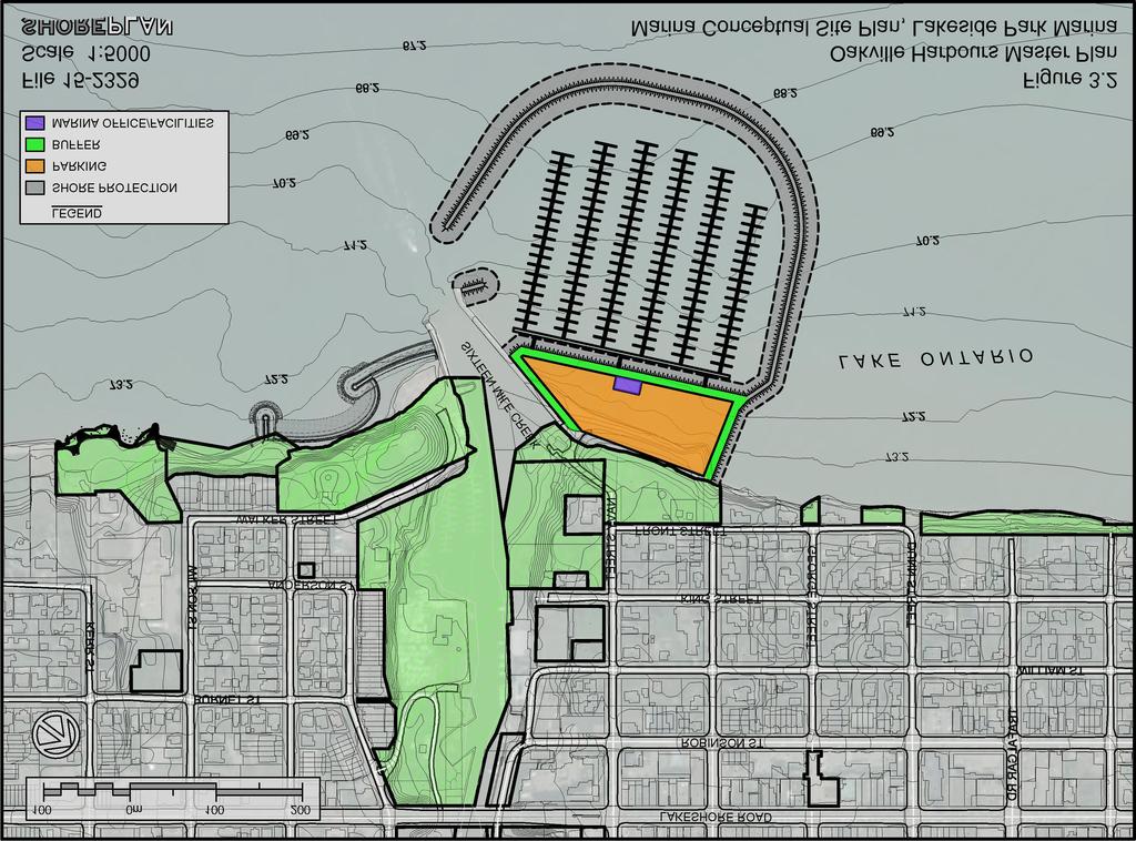
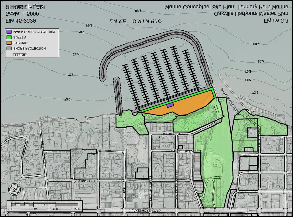
10 3.2 Conceptual Marina Layouts The methodology and design parameters used to develop the conceptual marina layouts are describedd below followed by a description of the conceptual layouts Methodology Each conceptual marina layout was developed to accommodate approximately 500 slips. A common slip size of 11 m was used to develop the conceptual dock layouts. The 11 m slip was used as a representative average slip size. A mix of larger and smaller slips would be incorporated in the later stages of the marina layout development. The 11 m slip used has a finger dock length of 11 m and a finger dock width of 1 m. A fairway width of 222 m was used for the internal aisles. Around the perimeter of the marina, a minimum 30 m clearance was allowed between the docks and the 72.2 m (2 metres below datum water level) on the existing and proposed shoreline protection structures. The m (-2 m contour) was used as the navigation contour for the development of conceptual layouts. Our initial approach was to locate the docks where the existing lakebed is 72.2 m or lower and fill to createe a landmasss out to the 72.2 m contour. At most of the sites, this resulted in a land mass that was, in our opinion, excessively large. To get a realistic and compact marina footprint, some dredging during the initial construction would be required for most of the conceptual layouts. The marinas are enclosed by stone breakwaters. The conceptual breakwaterr section used at the conceptual design stage has a 5 m wide crest and side slopes of 2h:1v. The structure consists of layers of armour stone overlaying a core.. For the conceptual cost estimate, we assumed that the sides of the landmass created by the lake infilling would be protected by a revetment structure. We allowed a 10 m wide buffer landward of the crestt of the shore protection structure. This buffer provides an allowance for the crest of the shore protection structure, a walkway, landscaping and buffers. An area of approximately 5000 m 2 was allowed for a marina building with basic amenities. The areaa bound by the landward limit of the buffer and the existing shoreline, and excluding the marina building, was counted as parking area Conceptual Marina Layouts The five conceptual marina layouts are presented on Figure 3.2 through Figure 3.6, for Alternatives 1 through 5, respectively. A short description of each conceptual layout is provided below. Figure 3..2 presents a site plan of Alternativee 1 Lakeside Park Marina. The conceptual marina layout is located on the east side of the existing Sixteenn Mile Creek entrance piers. The marina backs onto Lakeside Park. The shoreline was filled to create a landmass for the required amount of parking. Approximately 15,500 m 2 of area for parking is created. Six main docks provide 492 slips and extend from the land mass approximately perpendicular to the existing 6
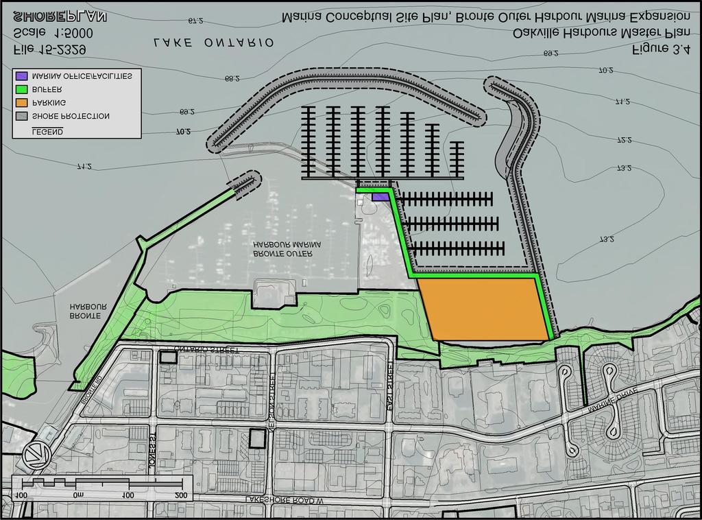
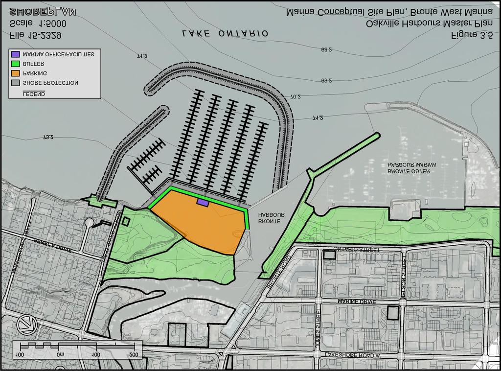
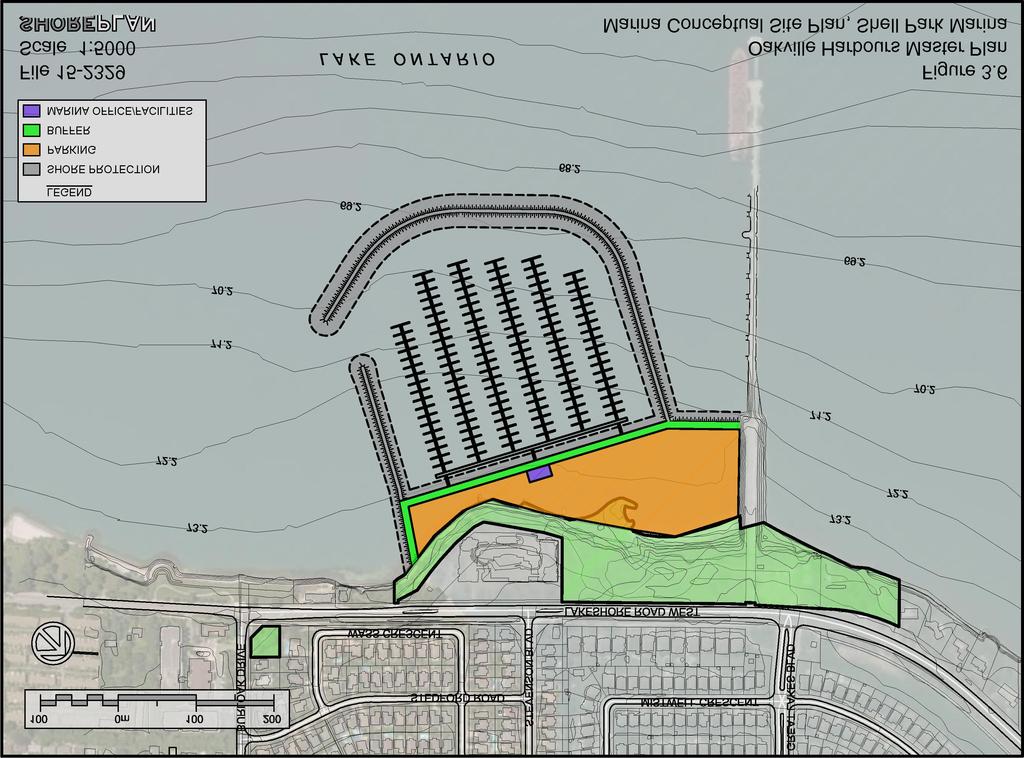
11 shoreline. The existing bathymetry contours indicate that no or minimal dredging would be required. The marinaa entrance is located just south of the existing entrance piers to Sixteen Mile Creek. An addition or modification to the existing east entrance groyne may be required to reduce wave penetration into the basin. A site plan of Alternative 2 is shown on Figure 3.3 Tannery Park Marina. The conceptual marina layout is located on the west side of the existingg Sixteen Mile Creek entrance piers. The shorelinee was filled to create a sufficient landmass area for the equired minimum amount of parking. Approximately 15,400 m 2 of parking area is created. The east breakwater extends from the end of the existing west entrance pier along approximately the same alignment. Seven docks extend along approximate ely the same alignment as the east breakwater and existing west entrancee pier. The marina entrance is located in the south-west corner of the marina basin. The marina basin is sheltered from the west by a breakwater that extends from the west side of Waterworks Park. Some dredging would be required in the northwest part of the basin to provide a lake bed elevation of 72.2 m or lower within the entire basin. Figure 3..4 presents a site plan of Alternativee 3 Brontee Outer Harbour Marinaa Expansion. The conceptual layout involves expanding the existing Bronte Outer Harbour Marina to the south and east to create an additional 482 slips. The existing east stone breakwater would be removed and new breakwaters constructed around thee perimeter of the new marina. Parking and other land-based facilities are located on the lake infill area along the shoreline of Waters Edge Park. Approximately 25,700 m 2 of parking is created. Two marina entrances are proposed for the expanded marina. The entrance to the existingg Bronte Outer Harbour Marina will be modified slightly to address existing wave agitation problems in the basin. A second entrance is created at the southeast corner of the expanded marina basin. The northern part of the expanded marina basin will need to be dredged too provide suitable water depths. This alternative requires the most dredging of all the alternatives. A site plan for Alternative 4 Bronte Harbour West is shown on Figure 3.5. The site is located on the west side of Bronte Harbour in front of Bronte Bluffs Park and Bronte Beach Park. Approximately 24,500 m 2 of infill area is created along the shorelines of the parks. The conceptual dock layout has four docks extending perpendicular to the existing shoreline and two shorter docks in the west part of the basin at an anglee to the shoreline. The west breakwater extends from Harbourside Park, to the west of W River Street Right-of-Way. The east breakwater extends from the end of the existing west entrance groyne to Bronte Harbour. The north-west part of the marina basin would need to be dredged during the construction to lower the existing lake bed to the navigational depth. Figure 3..6 presents a site plan for Alternative 5 Shell Park. The conceptual marina is located on Lakeshore Road at Shell Park. A land mass is created by filling along the publically owned shorelinee out to the end of the stone protection along the Shell Pier. This alternative creates 33,600 m 2 of area that could be used for parking and other uses; the most of all the alternatives. The east marina breakwater is offset from the pier andd extends at an angle slightly away from the pier so as to maintain access and maneuvering space around the pier which is still used by large ships. Six docks extend along the same alignment as the east breakwater. The marina 7
12 entrancee is located at the south west cornerr of the basin. Dredgingg is required in the northwest part of the marina basin. Table 3. 1 provides alternative. a summary of the number of slips and parking area provided by Table 3.1: Summary of Marina Concepts each Alternativee 1 Lakeside Park Marina 2 Tannery Park Marina 3 Bronte Outer Harbour Marina Expansion 4 Bronte West Marinaa 5 Shell Park Marina Number of Slips Parking Area 15,500 m 2 15,400 m 2 25,700 m 2 24,500 m 2 33,600 m 2 Table 3.2 provides a summary of the ratios of parkingg and winter storage provided for each conceptual layout. The ratio of parking spaces per slip was calculated using the actual parking area and slip counts for each of the layouts. The winter r storage percentage is the ratio of boats that can be stored on land during the winter to the total number of slips. It was calculated by dividing the parking area by the approximate area per boat in winter storage described in Section We note that this assumes that the entiree parking area would be used for winter storage in the winter months. In practice, it may be desirable to only use a portion of the parking area for winter storage. Table 3.2: Summary of Parking and Winter Storage Alternativee 1 Lakeside Park Marina 2 Tannery Park Marina 3 Bronte Outer Harbour Marina Expansion 4 Bronte West Marinaa 5 Shell Park Marina Parking Spaces per Slip Winter Storage Provided 45% 43% 76% 72% 96% 8
13 Preliminary construction cost estimates were prepared for the five conceptual marina layouts. The cost estimates were calculated using unit prices are derived from similar projects recently completed in south Ontario. The armour stone cost may vary depending on the availability of material at the time of construction. Allowances for electrical supply and dock anchors were based on typical proportions of the dock costs. An allowance of $2.5 million was added for the marina centre. For the surfacing and landscaping of the backshore, we have assumed that 30 % of the sum of the buffer and parking area would be landscaping and the remaining 70% would be paved with asphalt. The cost estimates for the five alternatives are presented in Table 3.3. A more detailed breakdown of the construction cost estimatee for each alternative is provided in Appendix A. In the summary table a total construction cost estimate and a costt per slip are provided. The construction cost estimates do not include any mobilization and demobilization, construction contingencies, design costs or taxes (HST). We suggest that a minimum 30% contingency for design and construction is applied at the conceptual design stage. Table 3.3: Preliminary construction cost estimates forr marina concepts Alternative 1 Lakeside Park Marina 2 Tannery Park Marina 3 Bronte Outer Harbour Marina Expansion 4 Bronte West Marina 5 Shell Park Marina Total Cost Estimate $44.5 million $45.1 million $58.3 million $43.9 million $50.6 million Cost per Slip $91,000 $88,000 $121,000 $90,000 $101, Approval Process and Comments on Site Selections The implementation of a marinaa by the, similar to the concepts described in this report, will require a number of steps and the acceptance of approval agencies. First, the will need to make a formal decision to proceed with the undertaking. Under the Environmental Assessment Act, an Individual Environmental Assessment (IEA) would need to be completed for the project. The IEA process starts with the preparation of Terms of Reference that need to be approved by the Minister of the Environment and Climate Change (MOECC). The term of reference are developed with public input and define the objectives of the undertaking and scope of assessment. The scope could be limited to a site or include all potential sites within the town and could include alternate boat storage arrangement. Any assessment of sites prior to the approval of the terms off reference is premature. 9
14 Following the completion and approval of the EA and thee detailed design, the project will equire approval from regulating agencies. A permit from Conservation Halton under Ontario Regulation 162/06 and an MNRF Work Permit would be required. A purchase of lease of crown land from MNRF of the water lot occupied by the new structures iss likely to be required for all alternatives. All alternatives would require review by Transport Canada under the Navigation Protection Act because of the extent of the works beyond the high water mark. Authorization from Department of Fisheries and Oceans Canada (DFO) under the Fisheries Act would likely be required. DFO would likely consider the work to result in serious harm due to the loss of fish habitat due to the footprint of the structures. DFO will likely require offsetting measures, such as the creation of aquatic habitat features, to offset the loss of fish habitat. We note that an allowance for aquatic habitat creation was not carried in the construction cost estimates described above. 3.4 Comments on Site Selections The concepts developed at the six sites presented above in Section 3.2 have not been assessed or compared in a way that would allow selection of a site or a particular design concept. The information provided herein outlines the physical requirements and a sense of scale for the type of marina facility that could operate efficiently and profitably. The assessment answers the question Are there publically owned sites that can allow the construction of a public marina on Lake Ontario? The assessment clearlyy affirms the existence of such sites. All sites will provide many challenges and opportunities should the Town decidee to proceed with the undertaking. Many compromises will need to be made at any and all of the sites. The EA process will allow for this decision process within the context of a public consultation process. Constructing such a large facility will clearly change the parkland uses at the identified locations, likely to more active and structured spaces. New locations may need to be found for the displacedd uses. The views along the waterfront will bee changed, but the proposed structures may also provide an opportunity for new views along the shore. The uses along the waterfront will clearly change; possibly providing opportunity forr some commercial activity, but public access along the shore can be maintained and should be one of the corner stones of any marina developmen t considered. Each of the sites provides a different connection to the existing community and will provide a different experience for the boaters, particularly visiting transient boaters from other communities. Some locations connect to the commercial core of the Town while others provide more remote and quiet location. Challenges will be posed by any of the concepts and locations. Parking and vehicular access is likely to be one of the most significant challenges. Public transit connections will need to be investigated and enhanced as much as possible. Impacts on adjacent neighbourhoods during the construction and during operations will need to be considered. The construction implementation of such a project is likely to be a multi-yeaof material being delivered. Winter storage of boats undertaking with heavy equipment operating on the sites and many truckloads will also provide a challenge as the parking anticipated to be provided at each site can only accommodate about one quarterr of the boats that can use the marina. 10
15 There will also be impacts on the natural environment including aquatic and terrestrial habitat and coastal processes. The construction of breakwaters often provides an opportunity to constructt new features and provide sheltered habitat along an open coast. 11
16

17
18
19
20
21
22
23
24 4 Launching Facilities The Region of Peel Boating study identified a need for additionall launching future demand. The following provides a short summary of planning considerations for launching facilities. facilities to parameters meet and The main land space requirements for a launch rampp are for maneuvering space and car & trailer parking. As a rule of thumb, allowing a minimum of 20 car and trailer parking spaces per launch lane is recommended at the planning stage (ASCE, 2012, Small Craft Harbours Branch, 1992). The recommended space requirements per parking space vary from approximately 150 m 2 /car and trailer space on average (ASCE, 2012) to 250 m 2 per car and trailer space (Small Craft Harbours Branch, 1992). This equates to an area of 3,000 to 5,000 m 2 for 20 spaces. The space requirements for the car and trailer parking can be minimized by incorporating some one- and turning space is also required adjacent to the ramp. Small Craft Harbours Branch (1992) recommends an area at least m by m. This equates to an area of approximately 1,500 m 2. We note that the areas described are for a single launch lane. Launch ramps with way circulation and minimizing landscaping, for example. In addition to parking, maneuvering more than one lane are common on Lake Ontario. The ideal site for a launch ramp is relatively sheltered and has sufficient water depth at the end of the ramp. In theory, it would be possible to incorporate launching facilities into one of the conceptual marina basins described in Section 3. In practice, bringing the two groups of boaters (launch ramp users and marina basin users) can often create tension. This is sometimes attributed to wake and noise generation in the basin, for example. In addition, and as described above, the space demands of the launching facilities, manoeuvering area and car & trailer parking are considerable. Potential conflict can be minimized by separating the two groups as much as possible in the same facility through careful layout. The alternative would be to consider constructing a launch ramp at a separate location. Sites on Lake Ontario would likely require the construction of a breakwater or the modification of existing shore protection to shelter the ramp. Developing conceptual launch rampp layouts was beyond the scope of the present work. Facilities could also be providedd for small boat accesss (canoes, kayaks etc.). A floating dock could be incorporated into a launch ramp facility. There are also purpose designed docks for kayaks and canoes on the market. We understand that the shorelines of some parks in Oakville are presently used to launch small boats. An alternative to providing new small boat access could be to formalize a small craft launching area at onee of these locations. 18
25 References American Society of Civil Engineers (ASCE) (2012). Planning and Design Guidelines for Small Craft Harbors, Third Edition, Published by the American Society of Civil Engineers, 2012 Department of Fisheries and Oceans Accommodation Canada (DFO) (1985). Guidelines of Harbour Ross, N..W. (1989) Auto Parking in Marinas, published in Marinas: Planning and Feasibility, Proceedings of the International Conferencee on Marinas, Editors: W.R. Blain and N.B. Webber Small Craft Harbours Branch (1992) Planning Guidelines for Recreational Harbours in Ontario, prepared for Department of Fisheries and Oceans (DFO) Canada, by Hough Stansbury Woodland Limited, September 1992 (2014) Town February 25, 2014 of Oakville Zoning By-Law , Passed by Council on 19
26
27 Appendix A
28
29 Oakville Harbours Master Plan May 22, 2018 Summary of Cost Estimates of Conceptual Marinas Lakeside Park Marina Tannery Park Marina Bronte Outer Harbour Marina Expansion Bronte West Marina Shell Park Marina Docks $ 5,360, $ 5,790, $ 5,550, $ 5,760, $ 5,430, Shore Protection/Breakwaters $ 31,770, $ 28,980, $ 31,850, $ 24,350, $ 29,930, Fill $ 3,550, $ 3,870, $ 5,460, $ 4,890, $ 7,790, Dredging $ $ 2,710, $ 10,990, $ 4,620, $ 2,550, Parking and Landscaping $ 1,170, $ 1,120, $ 1,820, $ 1,610, $ 2,230, Buildings $ 2,660, $ 2,660, $ 2,660, $ 2,660, $ 2,660, Total $ 44,510, $ 45,130, $ 58,330, $ 43,890, $ 50,590, Number of Slips Cost per Slip $ 90, $ 87, $ 121, $ 90, $ 101, NOTES Construction cost estimates do not include contingencies, allowances, site access, design fees or HST. Minimum 30% allowance for design and construction is recommended
LaSalle Park Marina Wave Break
 LaSalle Park Marina Wave Break Federal and Municipal Environmental Assessment Background History of the Marina and LaSalle Park The LaSalle Park Marina is located in LaSalle Park at the foot of LaSalle
Recreational Boating Feasibility and Capacity Study
 TOURISTICS + Shoreplan Engineering Limited were retained by: Town of Oakville; City of Burlington; and Regional Municipality of Halton. Note: Throughout the presentation boat lengths are identified in
TOURISTICS + Shoreplan Engineering Limited
 TOURISTICS + Shoreplan Engineering Limited i TABLE OF CONTENTS LIST OF TABLES... iii LIST OF FIGURES... iii LIST OF EXHIBITS... iii EXECUTIVE SUMMARY... vii SECTION 1 - INTRODUCTION... 1 1.0 Background...
Pier 8 Wave Overtopping Analysis (65 Guise Street East) Our File:
 Our File:") Shoreplan Engineering Limited 55 Eglinton Avenue E., Suite 800 Toronto, ON Canada M4P 1G8 T) 416.487.4756 F) 416.487.5129 E) mail@shoreplan.com March 31, 2016 Mr. Ed English Senior Project Manager Waterfront
Shoreplan Engineering Limited 55 Eglinton Avenue E., Suite 800 Toronto, ON Canada M4P 1G8 T) 416.487.4756 F) 416.487.5129 E) mail@shoreplan.com March 31, 2016 Mr. Ed English Senior Project Manager Waterfront
Redondo Beach Boat Launch Ramp Facility
 Redondo Beach Boat Launch Ramp Facility Feasibility Report for the California Department of Boating and Waterways 2015 Grant Cycle For the City of Redondo Beach Submitted by March 13, 2014 Table of Contents
Technical Brief - Wave Uprush Analysis Island Harbour Club, Gananoque, Ontario
 Technical Brief - Wave Uprush Analysis RIGGS ENGINEERING LTD. 1240 Commissioners Road West Suite 205 London, Ontario N6K 1C7 October 31, 2014 Table of Contents Section Page Table of Contents... i List
BILLY BISHOP TORONTO CITY AIRPORT PRELIMINARY RUNWAY DESIGN COASTAL ENGINEERING STUDY
 Bâtiment Infrastructures municipales Transport Industriel Énergie Environnement BILLY BISHOP TORONTO CITY AIRPORT PRELIMINARY RUNWAY DESIGN COASTAL ENGINEERING STUDY N. Guillemette 1, C. Glodowski 1, P.
Waterfront User Needs Assessment & Detailed Design RESPONSE TO COMMENTS
 Waterfront User Needs Assessment & Detailed Design RESPONSE TO COMMENTS Town of Cobourg Presentation to Council Monday July 3, 2018 4 PM 1 Response topics Opportunity to clarify and correct misinterpretations
# Post Consultation and Submissions Resource Consent Conditions for Surfing Impact Mitigation August 2016
 # Post Consultation and Submissions Resource Consent Conditions for Surfing Impact Mitigation August 2016 Surf Mitigation Management Plan 1 1 Not less than 6 months prior to the commencement of the construction
MEMORANDUM. Existing Operations. City of Clearwater. Michael Herrman. Date: January 26, Seminole Boat Launch Overview. M&N Job No.
 1509 W. Swann Avenue, Suite 225 Tampa, FL 33606 (813) 258-8818 Fax (813) 258-8525 www.moffattnichol.com MEMORANDUM To: From: City of Clearwater Michael Herrman Date: Subject: Seminole Boat Launch Overview
HARBOR INFRASTRUCTURE INVENTORIES Marquette Harbor, Michigan
 HARBOR INFRASTRUCTURE INVENTORIES Marquette Harbor, Michigan Harbor Location: Marquette Harbor is located in Marquette Bay on the south shore of Lake Superior, 160 miles west of Sault Ste. Marie, MI and
Comments The Plan for Port Whitby
 Comments The Plan for Port Whitby April 24th, 2013 Community Meeting #2 Summary Report Prepared by GLPi April 29th, 2013 1 Introduction The purpose of the Port Whitby Secondary Plan Update, Community Improvement
OPEN HOUSE WELCOME Bronte Village Growth Area Review
 OPEN HOUSE WELCOME Bronte Village Growth Area Review Bronte Village is a growth area. Learn more! Introduction Bronte Village is a growth area. What is that? Bronte Village is one of six growth areas identified
Technical. BACKGROUND corridor from. The Castle Rock. To: RE: SH 86-Founders. results and. as high volumes. This. no formal. intersection.
 Technical Memorandum To: The Castle Rock Town Council and Public Works Commission From: CDOT Region 1 Traffic Operations Unit RE: SH 86-Founders Pkwy/Allen Way Intersection Assessment of Alternatives INTRODUCTION
DRAFT. October 17, 2014 File No Mr. Brendhan Zubricki Town Administrator Essex Town Hall 30 Martin Street Essex, MA.
 GZA GeoEnvironmental, Inc. Engineers and Scientists October 17, 2014 File No. 18.0171857.00 Mr. Brendhan Zubricki Town Administrator Essex Town Hall 30 Martin Street Essex, MA. 01929 DRAFT Re: Essex River
HARBOR INFRASTRUCTURE INVENTORIES West Harbor, OH
 HARBOR INFRASTRUCTURE INVENTORIES West Harbor, OH Harbor Location: West Harbor is located on the southern shore of Lake Erie in the township of Catawba Island, OH about 50 miles east of Toledo, OH. Authority:
APPENDIX 2 LAKESHORE ROAD TRANSPORTATION REVIEW STUDY EXECUTIVE SUMMARY
 APPENDIX 2 LAKESHORE ROAD TRANSPORTATION REVIEW STUDY EXECUTIVE SUMMARY Appendix 2 City of Mississauga Lakeshore Road FINAL REPORT Transportation Review Study December 2010 EXECUTIVE SUMMARY Study Purpose
TRANSPORTATION NEEDS ASSESSMENT
 TRANSPORTATION NEEDS ASSESSMENT A travel demand analysis was carried out to determine the operational issues and the potential benefit that adding traffic capacity would have on the road network. All the
4. ENVIRONMENTAL IMPACT ANALYSIS 9. TRANSPORTATION AND TRAFFIC
 4. ENVIRONMENTAL IMPACT ANALYSIS 9. TRANSPORTATION AND TRAFFIC 4.9.1 INTRODUCTION The following section addresses the Proposed Project s impact on transportation and traffic based on the Traffic Study
WOODFIBRE LNG VESSEL WAKE ASSESSMENT
 Woodfibre LNG Limited WOODFIBRE LNG VESSEL WAKE ASSESSMENT Introduction Woodfibre LNG Limited (WLNG) intends to build a new LNG export terminal at Woodfibre, Howe Sound, British Columbia. WLNG has engaged
A New Strategy for Harbor Planning and Design
 A New Strategy for Harbor Planning and Design Xiuying Xing, Ph.D Research Associate Sonny Astani Department of Civil and Environmental Engineering University of Southern California Los Angeles, CA 90089-2531
HARBOR INFRASTRUCTURE INVENTORIES Oak Orchard Harbor, New York
 HARBOR INFRASTRUCTURE INVENTORIES Oak Orchard Harbor, New York Harbor Location: Oak Orchard Harbor is located on the southern shore of Lake Ontario at the mouth of Oak Orchard Creek in the village of Point
TRAFFIC IMPACT STUDY CRITERIA
 Chapter 6 - TRAFFIC IMPACT STUDY CRITERIA 6.1 GENERAL PROVISIONS 6.1.1. Purpose: The purpose of this document is to outline a standard format for preparing a traffic impact study in the City of Steamboat
Chapter 3 DESIGN SPECIFICATIONS
 Brampton PathWays Planning and Design Guidelines 27 Chapter 3 DESIGN SPECIFICATIONS 3.1 CLASS 1 MULTI-USE PATH Off-road multi-use trails are the backbone of the Brampton PathWays Network. They are typically
HARBOR INFRASTRUCTURE INVENTORIES Fairport Harbor, OH
 HARBOR INFRASTRUCTURE INVENTORIES Fairport Harbor, OH Harbor Location: Fairport Harbor is located at the mouth of the Grand River on the southern shore of Lake Erie in the city of Fairport, OH, approximately
ROYAL VANCOUVER YACHT CLUB
 ROYAL VANCOUVER YACHT CLUB PROPOSED EXPANSION PROJECT NAVIGATION CHANNEL DESIGN COAL HARBOUR Prepared for: Royal Vancouver Yacht Club Prepared by: Typlan Consulting Ltd. March 2016 Page 1 of 17 March 23,
Welcome to the Open House
 Leslie Street Between 19 th Avenue and Stouffville Road Addendum to Class Environmental Assessment Study Welcome to the Open House Please sign in at the front desk. March 28, 2017 Richmond Green Sports
Planning of Major Recreational Boating Facilities at Shell Cove Boat Harbour
 Planning of Major Recreational Boating Facilities at Shell Cove Boat Harbour B Morgan 1, Deborah Lam 1, Glenn Colquhoun 2 1 Advisian, Sydney, NSW 2 Frasers Property Australia, Shell Cove, NSW Abstract
Port Elgin Harbour Strategic Assessment. Study undertaken by TOURISTICS and Shoreplan Engineering Limited
 Study undertaken by TOURISTICS and Shoreplan Engineering Limited 1 Study included: Review of existing recreational boating facilities in Bruce and Grey Counties An analysis of trends in recreational boating
City of Rolling Hills Equestrian Facility Guidelines
 City of Rolling Hills Equestrian Facility Guidelines Drafted by the Stable Ad Hoc Committee STABLE GUIDELINES 1 2 [STABLE GUIDELINES] 2017 INTRODUCTION The Rolling Hills City Council noted a recent trend
Welcome! Did You Know...? Aquatic Centre Dock Rebuild. Key Objectives
 1 Welcome! Aquatic Centre Dock Rebuild The City of Vancouver is improving the dock at the Vancouver Aquatic Centre, which is nearing the end of its service life and is in need of replacement. This creates
Prepared For: Shieldbay Developments Inc. c/o Matson, McConnell Ltd. 2430A Bloor Street West Toronto, Ontario M6S 1P9.
 Prepared For: Shieldbay Developments Inc. c/o Matson, McConnell Ltd. 2430A Bloor Street West Toronto, Ontario M6S 1P9 Prepared By: URS Canada Inc. 4 th Floor, 30 Leek Crescent Richmond Hill, Ontario L4B
CORPS FACTS. Harbor Dredging U.S. ARMY CORPS OF ENGINEERS BUILDING STRONG
 CORPS FACTS Harbor Dredging U.S. ARMY CORPS OF ENGINEERS BUILDING STRONG Disaster Response Sedimentation in the channel is caused by the normal cycle of silt movement, erosion from high water or heavy
CHAPTER 6 10/29/2018 Clean Version REGULATING PIERS, WHARVES, MOORING BUOYS, SWIMMING RAFTS AND INFLATABLES ON ROCK LAKE
 1 2 3 4 5 6 7 8 9 10 11 12 13 14 15 16 17 18 19 20 21 22 23 24 25 26 27 28 29 30 31 32 33 34 35 36 37 38 39 40 41 42 43 44 45 46 CHAPTER 6 10/29/2018 Clean Version REGULATING PIERS, WHARVES, MOORING BUOYS,
HARBOR INFRASTRUCTURE INVENTORIES Lorain Harbor, Ohio
 HARBOR INFRASTRUCTURE INVENTORIES Lorain Harbor, Ohio Harbor Location: Lorain Harbor is located on the southern shore of Lake Erie in the city of Lorain, OH about 45 miles west of Cleveland, OH. Authority:
Implications of proposed Whanganui Port and lower Whanganui River dredging
 PO Box 637 Wanganui 4540 Attention: Rowan McGregor Dear Rowan 1 Summary We understand that it has been proposed to bring large vessels into the Port at Whanganui requiring the excavation of a channel up
CURBSIDE ACTIVITY DESIGN
 5 CURBSIDE ACTIVITY DESIGN This chapter provides design guidance for separated bike lanes adjacent to curbside activities including parking, loading and bus stops. Typical configurations are presented
to the Public Information Centre for the Downtown Traffic Study
 to the Public Information Centre for the Downtown Traffic Study City of Sault Ste. Marie July 25, 2018 Purpose of Study Determine if changes to one-way corridors can enhance downtown s character and spaces
PE17.1 REPORT FOR ACTION
 PE17.1 REPORT FOR ACTION Encouraging a paddling and fishing friendly City Date: February 2, 2017 To: Parks and Environment Committee From: General Manager, Parks, Forestry and Recreation Division Wards:
Water Resources Report RKLD Annual Meeting July 30, 2016
 Water Resources Report RKLD Annual Meeting 2016 July 30, 2016 Topics Hydrology Report Indianford Dam trash rack cleanout performance Experimental Project update Review of PAS project Twin floods- 1 to
Sixth Line Development - Transit Facilities Plan
 Memorandum Date: November 13, 2012 To: From: c.c. Subject: Rob Freeman (Freeman Planning) Kevin Phillips Sixth Line Development - Transit Facilities Plan 33016631 This memo was prepared to review the transit
Access Management Guidelines February 2013 THE CITY OF
 Access Management Guidelines February 2013 THE CITY OF Table of Contents Introduction 2 Review and Approval Process 5 Technical Guidelines 9... 10... 12 3. Separation Distance: Non-Signalized All-Turns
REPORT. Engineering and Construction Department
 REPORT COMMUNITY SERVICES COMMITTEE MEETING DATE: JUNE 11, 2013 FROM: Engineering and Construction Department DATE: May 24, 2013 SUBJECT: Great Lakes Boulevard Mini Roundabout LOCATION: Great Lakes Boulevard
HARBOUR SEDIMENTATION - COMPARISON WITH MODEL
 HARBOUR SEDIMENTATION - COMPARISON WITH MODEL ABSTRACT A mobile-bed model study of Pointe Sapin Harbour, in the Gulf of St. Lawrence, resulted in construction of a detached breakwater and sand trap to
Designing a Harbor Entrance to Defeat Swell Wave Agitation. FAX (506) ; 2
 ; 2") Designing a Harbor Entrance to Defeat Swell Wave Agitation Mauricio Wesson, MSc. PE 1 and Jack C. Cox, PE, DPE, DCE, DNE 2 1 Watermark, La Sabana, San Jose, Costa Rica; PH (506) 2220-1198; FAX (506) 2290
Designing a Harbor Entrance to Defeat Swell Wave Agitation Mauricio Wesson, MSc. PE 1 and Jack C. Cox, PE, DPE, DCE, DNE 2 1 Watermark, La Sabana, San Jose, Costa Rica; PH (506) 2220-1198; FAX (506) 2290
SELECTION OF THE PREFERRED MANAGEMENT OPTION FOR STOCKTON BEACH APPLICATION OF 2D COASTAL PROCESSES MODELLING
 SELECTION OF THE PREFERRED MANAGEMENT OPTION FOR STOCKTON BEACH APPLICATION OF 2D COASTAL PROCESSES MODELLING C Allery 1 1 DHI Water and Environment, Sydney, NSW Abstract This paper presents an approach
Coastal and marine recreation in New England is ingrained in the region s economic and
 RECREATION Coastal and marine recreation in New England is ingrained in the region s economic and social fabric. Recreation on the ocean and coast includes many of New Englanders most time-honored and
HARBOR INFRASTRUCTURE INVENTORIES Port Sanilac Harbor, Michigan
 HARBOR INFRASTRUCTURE INVENTORIES Port Sanilac Harbor, Michigan Harbor Location: Port Sanilac Harbor is located on the west shore of Lake Huron, about 30 miles north of Port Huron, MI. Authority: Rivers
C C C
 C-012-001 Thank you for your support for the creation of new public space and nonmotorized access between downtown and the waterfront through the Overlook Walk, the East-West Connections, and the Promenade.
102 Avenue Corridor Review
 February 26, 2015 102 Avenue Corridor Review Transportation Association of Canada Road Safety Engineering Award Submission for the City of Edmonton Introduction Transportation Association of Canada Road
TRAVEL PLAN: CENTRAL EUROPEAN UNIVERSITY CAMPUS REDEVELOPMENT PROJECT TRAVEL PLAN. Central European University Campus Redevelopment Project.
 TRAVEL PLAN Central European University Campus Redevelopment Project Page 1 Table of Contents Introduction... 3 Background... 7 Building Users... 7 Transportation in Community Consultation... 7 Summary
UBCM Community Excellence Awards 2007 Submission
 UBCM Community Excellence Awards 2007 Submission Formatted: Left: 2.54 cm Category: Partnerships Project: Implementation of False Creek Anchoring Management System 1. A one-paragraph summary of the project/program
10.0 CURB EXTENSIONS GUIDELINE
 10.0 CURB EXTENSIONS GUIDELINE Road Engineering Design Guidelines Version 1.0 March 2017 City of Toronto, Transportation Services City of Toronto Page 0 Background In early 2014, Transportation Services
Introduction to Roadway Design
 Chapter Introduction to Roadway Design 1 This chapter lays the foundation for the Roadway Design course. You examine the roadway design workflow and the completed drawing files and review the project scope,
M-58 HIGHWAY ACCESS MANAGEMENT STUDY Mullen Road to Bel-Ray Boulevard. Prepared for CITY OF BELTON. May 2016
 M-58 HIGHWAY ACCESS MANAGEMENT STUDY Prepared for CITY OF BELTON By May 2016 Introduction Missouri State Highway 58 (M-58 Highway) is a major commercial corridor in the City of Belton. As development has
2010 Kemp Lake Angling and Lake Infrastructure Improvement Proposal
 2010 Kemp Lake Angling and Lake Infrastructure Improvement Proposal Prepared for: Capital Regional District Juan de Fuca Electoral Area Community Parks and Recreation #2-6868 West Coast Road P.O. Box 283,
HARBOR INFRASTRUCTURE INVENTORIES Harbor Beach Harbor, Michigan
 HARBOR INFRASTRUCTURE INVENTORIES Harbor Beach Harbor, Michigan Harbor Location: Harbor Beach Harbor is located on the west shore of Lake Huron about 60 miles north of Port Huron, MI. Authority: Rivers
TO: FROM: Y.102/MIN
 TO: FROM: Hastings-on-Hudson Shoreline Committee Amanda Ludlow and Kathryn Sommo, Roux Associates, Inc. DATE: March 13, 2017 RE: Meeting with NYSDEC Region 3 Hastings-on-Hudson Conceptual Shoreline Plans
CITY OF NEWPORT BEACH HARBOR COMMISSION STAFF REPORT
 CITY OF NEWPORT BEACH HARBOR COMMISSION STAFF REPORT Agenda Item No. 2 TO: FROM: SUBJECT: HARBOR COMMISSION Harbor Resources Division (City Manager's Office) Chris Miller, Harbor Resources Supervisor,
Americans with Disabilities Act Transition Plan for Public Right-of-Way Improvements
 Americans with Disabilities Act Transition Plan for Public Right-of-Way Improvements Prepared by: Public Works Department Engineering Division October 2015 Table of Contents Section I Introduction.. 3
MARLWOOD GOLF & COUNTRY CLUB WASAGA BEACH, ONTARIO
 MARLWOOD GOLF & COUNTRY CLUB WASAGA BEACH, ONTARIO Prepared for: Marlwood Golf & Country Club 445 Golf Course Road Wasaga Beach, Ontario L0L 2P0 Prepared by: MBTW Golf Design 255 Wicksteed Avenue Unit
31. Rosses Point Mini-Plan
 County Development Plan 2017-2023 Volume 2, Chapter 31 Rosses Point Mini-Plan 31. Rosses Point Mini-Plan Village profile Rosses Point is a coastal settlement located approximately 8 km north-west of Sligo
Dundas. Plan Propose. ed North Northea Town
 Dundas Trafalgar Inc. Transit Facilities Plan Propose ed North Oakville Residential Subdivision Northea ast Corner of Dundas Street and Trafalgar Road Town of Oakville 12237 December 2012 Table of Contents
Design of Stanley Park S-Curve
 ADMINISTRATIVE REPORT Date: May 4, 2001 TO: FROM: Author/Local: F. Klotzbach/7118 RTS NO. 01644 CC File No. Standing Committee on Transportation and Traffic General Manager of Engineering Services, in
Standards vs. Guidelines. Public Right-of Way Accessibility Guidelines (PROWAG)
") www.access-board.gov Public Right-of Way Accessibility Guidelines (PROWAG) Juliet Shoultz, P.E Transportation Systems Engineer US Access Board Standards vs. Guidelines Guidelines are developed by the Access
www.access-board.gov Public Right-of Way Accessibility Guidelines (PROWAG) Juliet Shoultz, P.E Transportation Systems Engineer US Access Board Standards vs. Guidelines Guidelines are developed by the Access
Washington State Parks comments to the Draft Clallam County Shoreline Master Program Update Consistency Review June 3, 2011
 Washington State Parks comments to the Draft Clallam County Shoreline Master Program Update Consistency Review June 3, 2011 Pg 10 Public access is typically discussed as a requirement placed on facilities
Lake Tahoe Shoreline Plan. 01 Scope
 Lake Tahoe Shoreline Plan 01 Scope 09.20.2016 1 Brief Description The Shoreline Plan needs a defined scope to focus work efforts and complete the planning process by the end of 2018 (within the existing
Welcome. If you have any questions or comments on the project, please contact:
 Welcome This drop-in public open house is intended to provide information about the Bay Street bike lanes project. This project proposes a dedicated cycling facility along Bay Street between Aberdeen Avenue
Chapter 3: Multi-Modal Circulation and Streetscapes
 CHAPTER 3: MULTI-MODAL CIRCULATION AND STREETSCAPES Chapter 3: Multi-Modal Circulation and Streetscapes Overview Streetscape improvements have already been completed for Depot Street between Main Avenue
The development of the historical harbour of Paphos, Cyprus H.J. van Wijhe*, M. Meletiou^ Division, P.O. Box 152, 8300 AD Emmeloord, The Netherlands
 The development of the historical harbour of Paphos, Cyprus H.J. van Wijhe*, M. Meletiou^ Division, P.O. Box 152, 8300 AD Emmeloord, The Netherlands Abstract The harbour of Paphos originates from ancient
TRAFFIC STUDY GUIDELINES Clarksville Street Department
 TRAFFIC STUDY GUIDELINES Clarksville Street Department 9/1/2009 Introduction Traffic studies are used to help the city determine potential impacts to the operation of the surrounding roadway network. Two
Exhibit 1 PLANNING COMMISSION AGENDA ITEM
 Exhibit 1 PLANNING COMMISSION AGENDA ITEM Project Name: Grand Junction Circulation Plan Grand Junction Complete Streets Policy Applicant: City of Grand Junction Representative: David Thornton Address:
Technical Brief - Wave Uprush Analysis 129 South Street, Gananoque
 Technical Brief - Wave Uprush Analysis 129 South Street, Gananoque RIGGS ENGINEERING LTD. 1240 Commissioners Road West Suite 205 London, Ontario N6K 1C7 June 12, 2013 Table of Contents Section Page Table
DEPARTMENT OF THE ARMY GALVESTON DISTRICT, CORPS OF ENGINEERS P.O. BOX 1229 GALVESTON, TEXAS CESWG-CDR (1145)
") DEPARTMENT OF THE ARMY GALVESTON DISTRICT, CORPS OF ENGINEERS P.O. BOX 1229 GALVESTON, TEXAS 77553-1229 REPLY TO ATTENTION OF CESWG-CDR (1145) TBD MEMORANDUM FOR All Galveston District Personnel. SUBJECT:
DEPARTMENT OF THE ARMY GALVESTON DISTRICT, CORPS OF ENGINEERS P.O. BOX 1229 GALVESTON, TEXAS 77553-1229 REPLY TO ATTENTION OF CESWG-CDR (1145) TBD MEMORANDUM FOR All Galveston District Personnel. SUBJECT:
CITY OF SAINT JOHN TRAFFIC CALMING POLICY
 CITY OF SAINT JOHN TRAFFIC CALMING POLICY VERSION: 1.0 April 10, 2012 Pedestrians, Cyclists and Motorists Sharing Street Spaces CONTENTS INTRODUCTION... 3 POLICY GOAL... 3 POLICY OBJECTIVES... 3 GUIDING
Summary of Water Access for Marinas and Public Boat Ramps
 Lake Tahoe Shoreline Plan Meeting Materials: Steering Committee Last Updated: 11-28-16 Summary of Water Access for Marinas and Public Boat Ramps Table 1: Marinas Buoy Field Assessment Marinas 1. North
HURRICANE SANDY LIMITED REEVALUATION REPORT UNION BEACH, NEW JERSEY DRAFT ENGINEERING APPENDIX SUB APPENDIX D SBEACH MODELING
 HURRICANE SANDY LIMITED REEVALUATION REPORT UNION BEACH, NEW JERSEY DRAFT ENGINEERING APPENDIX SUB APPENDIX D SBEACH MODELING Rev. 18 Feb 2015 1 SBEACH Modeling 1.0 Introduction Following the methodology
SARASOTA COUNTY GOVERNMENT Parks and Recreation
 SARASOTA COUNTY GOVERNMENT Parks and Recreation TO: Sarasota County Commission THROUGH: Randall H. Reid, County Administrator FROM: Carolyn Brown, Director, Parks and Recreation DATE: September 17, 2013
Heritage Research Report
 APPENDIX A Heritage Research Report Metro Marine June 2014 HERITAGE RESEARCH REPORT STATUS SHEET Street Address: 2508 Lakeshore Road West Roll Number: 2401020220073000000 Short Legal Description: PLAN
Implementing the New Fisheries Protection Provisions under the Fisheries Act
 Implementing the New Fisheries Protection Provisions under the Fisheries Act Part 1 Legislation and Policy * The information in this presentation represents concepts as they have been developed to this
HARBOR INFRASTRUCTURE INVENTORIES Caseville Harbor, Michigan
 HARBOR INFRASTRUCTURE INVENTORIES Caseville Harbor, Michigan Harbor Location: Caseville Harbor is located at the mouth of the Pigeon River on the east shore of Saginaw Bay, about 17 miles southwest of
Alaskan Way, Promenade, and Overlook Walk Final EIS
 I-065-001 As described in Section 3.7.2 of the Draft EIS, the loss of on-street and off-street parking may require drivers to park off-street or travel farther to find available on-street or off-street
Port Elgin Harbour Strategic Assessment Final Report
 Port Elgin Harbour Strategic Assessment Final Report January 2018 i ii Table of Contents EXECUTIVE SUMMARY... ix SECTION 1 - INTRODUCTION... 1 1.0 Background... 1 1.1 Study Approach... 1 1.2 Report Format...
Corpus Christi Metropolitan Transportation Plan Fiscal Year Introduction:
 Introduction: The Safe, Accountable, Flexible, Efficient Transportation Equity Act: A Legacy for Users (SAFETEA-LU) has continued the efforts started through the Intermodal Surface Transportation Efficiency
PUBLIC EXHIBITION OF COASTAL ZONE MANAGEMENT PLAN FOR COLLAROY-NARRABEEN BEACH AND FISHERMANS BEACH
 ITEM 8.3 REPORTING MANAGER TRIM FILE REF 2014/110936 ATTACHMENTS PUBLIC EXHIBITION OF COASTAL ZONE MANAGEMENT PLAN FOR COLLAROY-NARRABEEN BEACH AND FISHERMANS BEACH GROUP MANAGER NATURAL ENVIRONMENT 1
Ketchikan Harbors Thomas Basin and Bar Point Harbor
 Ketchikan Harbors Thomas Basin and Bar Point Harbor Condition of Improvements 30 December 2014 Thomas Basin & Bar Point Harbors Ketchikan, Alaska (CWIS No. 000631 & 087071) Authorization (1) Rivers and
City of Elizabeth City Neighborhood Traffic Calming Policy and Guidelines
 City of Elizabeth City Neighborhood Traffic Calming Policy and Guidelines I. Purpose: The City of Elizabeth City is committed to ensure the overall safety and livability of residential neighborhoods. One
List of Display Boards
 List of Display Boards Welcome Introduction Municipal Class Environmental Assessment (EA) Process Need and Justification for an Interchange Alternatives for Evaluation Vertical and Horizontal Alignments
Ottawa Beach Road Study
 Ottawa Beach Road Study Prepared For: Park Township September 30, 2014 Project No. G140303 OTTAWA BEACH ROAD STUDY PREPARED FOR: PARK TOWNSHIP SEPTEMBER 30, 2014 PROJECT NO. G140303 TABLE OF CONTENTS 1.0
Part 9 Specific Land Uses - Foreshore & Waterway Development
 7 FORESHORE AND WATERWAY DEVELOPMENT This section applies to the following development uses proposed within the foreshore area (defined by LM LEP 2014), and contains Council s specific requirements for
America s Cup 36, Auckland 2021 Marine Traffic Survey
 Report America s Cup 36, Auckland 2021 Marine Traffic Survey for Resource Consent Application, Wynyard Basin Prepared for Panuku Development Auckland (Client) Prepared by Beca Ltd (Beca) January 2018 Revision
Available online at ScienceDirect. Procedia Engineering 116 (2015 )
") Available online at www.sciencedirect.com ScienceDirect Procedia Engineering 116 (2015 ) 320 325 8th International Conference on Asian and Pacific Coasts (APAC 2015) Department of Ocean Engineering, IIT
Available online at www.sciencedirect.com ScienceDirect Procedia Engineering 116 (2015 ) 320 325 8th International Conference on Asian and Pacific Coasts (APAC 2015) Department of Ocean Engineering, IIT
Vision: Traditional hamlet with an attractive business/pedestrian friendly main street connected to adjacent walkable neighborhoods
 N D. Focus Area II Vision: Traditional hamlet with an attractive business/pedestrian friendly main street connected to adjacent walkable neighborhoods Transit Road Focus Area II is located in the Hamlet
Pattullo Bridge Replacement Project Community Connections Phase 2 Consultation. Appendix 3: Open House Display Boards
 Replacement Project Community Connections Phase 2 Consultation Appendix 3: Open House Display Boards November 2016 Welcome! Welcome to the Replacement Project Public Open House We Want to Hear from You
Arapahoe Square Zoning + Design Standards & Guidelines Task Force Meeting 9 January 27, 2016
 Arapahoe Square Zoning + Design Standards & Guidelines Task Force Meeting 9 January 27, 2016 Agenda 3:00 Opening/Welcome 3:15 Touch Base on Schedule and Milestones Moving Forward 3:20 Review the Overall
Bear Cove Coastline Reestablishment
 Coastal and Ocean Engineering Undergraduate Student Forum, COASTAL-2013 Faculty of Engineering and Applied Science, Memorial University, St. john s, NL, Canada March, 2013 Bear Cove Coastline Reestablishment
THE CHALLENGES OF A LARGE-AREA BATHYMETRIC SURVEY
 THE CHALLENGES OF A LARGE-AREA BATHYMETRIC SURVEY Agenda: - Introduction - Tender - Project Planning - Survey - Processing - Delivery - Conclusion 2 Introduction We know less of the oceans at our feet,
Mumford Terminal Replacement Opportunities Neighbourhood Open House. we are here. PHASE 2 Identifying and Evaluating Candidate Sites
 Welcome Replacement Opportunities Neighbourhood Open House. AGENDA PURPOSE 1. REVIEW the information boards 2. DISCUSS aspects of the project with the project team 3. SHARE your thoughts on replacement
Southbend to Prima Vista. October 30, Floresta Corridor Master Plan
 Application of a Complete Street initiative and how it might function operationally 8 8 Southbend to Prima Vista October 30, 2017 Presentation Agenda 2 Perspective and History Traffic projections, Levels
INTRODUCTION TO COASTAL ENGINEERING
 The University of the West Indies Organization of American States PROFESSIONAL DEVELOPMENT PROGRAMME: COASTAL INFRASTRUCTURE DESIGN, CONSTRUCTION AND MAINTENANCE A COURSE IN COASTAL DEFENSE SYSTEMS I CHAPTER