Beach Water Quality. Ewan Moffat, Environmental Health Specialist, Recreational Water Program
|
|
|
- Imogene Day
- 5 years ago
- Views:
Transcription

1 Beach Water Quality Ewan Moffat, Environmental Health Specialist, Recreational Water Program
2 Items to be Discussed Sampling Locations Advisories, General Advisories, Closures Sept, 2011 Power Outage Sewage Spill South County TJ River Issues Playas de Tijuana Sewage Spills Contact Information


3 AB-411 Sampling Locations North South 40 City Samples per week 45 DEH Samples per week
4 Advisory - Bacteria Exceedence Total Coliform > 10,000 cfu / 100 ml Fecal Coliform > 400 cfu / 100 ml Enterococcus > 104 cfu / 100 ml
5 Precautionary Advisory Excavation of Lagoon / River Outlet San Elijo, Los Penasquitos, Etc.
6 General (Rain) Advisory 72-hour Duration Following Significant Rain (>0.2 Coastal Areas). No Signs Posted Phone Message (619) Websites Updated Press Release
7
 Dog Beach, IB Pier Etc.")
8 Closures Confirmed SD County Sewage Spill (SSO) Dog Beach, IB Pier Etc. TJ River Impacts


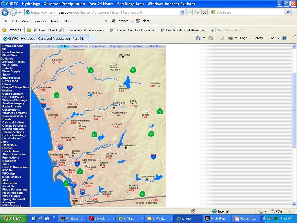
9 Example of SD County Sewage Spill SSO Spill Power Outage Pump Station Failure at Roselle Street

10 1.9 Million Gallon Spill Pump Station Failure in Roselle Street (Sorrento Valley) Most of the 1.9 Million Gallons went to Los Penasquitos Lagoon Outlet and Beaches Solana Beach, Del Mar, Torrey Pines to Scripps Pier Closed
11 Solana Beach to Scripps Pier Location of Spill Flow of Spill Outlet Beaches Closed Plume
12 Del Mar to Scripps Pier (Solana Beach Reopened) Location of Spill Flow of Spill Outlet Beaches Closed Plume Beaches Re-Opened
13 15 th St. Del Mar to Scripps Pier Location of Spill Flow of Spill Beaches Closed Beaches Re-Opened
14 Scripps Pier and Black s Beach Reopened. Location of Spill Flow of Spill Beaches Closed Beaches Re-Opened


15 Los Penasquitos Outlet One Mile North & South All Beaches Open Sept 14, 2011 (6-days Location of Spill later) Flow of Spill Beaches Closed Beaches Re-Opened All Beaches Open (6-days later)


16 South County TJ River Spills
17 Non Diverted TJ River Flow Beach Closure Saturn Blvd Dairy Mart Bridge TJ Foot Bridge

18 Dairy Mart Bridge Facing North
 Facing")
19 Not Diverted (Flow Under Dairy Mart Bridge) Facing South

20 View of TJ River from Dairy Mart Bridge facing west. Positive flow.
21 Non Diverted TJ River Flow Beach Closure Saturn Blvd Dairy Mart Bridge TJ Foot Bridge

22 View of TJ River from Saturn Blvd facing south. Positive flow. NOTE: River does not usually flow over the road. Usually one would look on east side (where the trees are) for flowing water.


23 Criteria for TJ Estuary Closure (Borderfield / TJSNWRS) Non Diverted TJ River Flow into US (Discharge to Beaches) Metal Contamination Warning Sign South End of Seacoast Flipped.
24
25 Diverted TJ River Flow Saturn Blvd Dairy Mart Bridge TJ Foot Bridge

26 View of TJ River from Dairy Mart Bridge facing east. No flow Entire area DRY.

27 Diverted (No Flow to Beaches) View of TJ River from Dairy Mart Bridge facing east. No flow entire area DRY.

28 Two Criteria for IB Closure Non Diverted TJ River Flow into US and Towards TJ Estuary Discharge to Beaches AND Significant S-N Nearshore Flow BOTH Criteria Must Exist for IB Closure
29 Methods to Verify IB Impacts Flowchart Combines: SCCOOS Website Field Observations Sample Results Forecasts (i.e. NW Swell?) The Combination of All of These Ensures the Best Decision

30 SCCOOS Website
31 Field Observations (IB Shoreline) Quality of Water (Odors, Color, Turbidity) Somewhat SUBJECTIVE Nearshore Flow Direction More OBJECTIVE
 North South Near Shore")
32 Fishermen Are Usually on Side of Pier at Direction of Nearshore Flow (so Lines Don t Go Under Pier) North South Near Shore Current.

33 Sample Results Used Primarily to Re-Open 24-hours to Get Results

34 Sample Locations to Reopen IB

35 Re Opening of TJ Estuary
36 Re Opening of TJ Estuary Sequence of Events Diverted TJ River flow (Turned on) ~ One week wait (flush out TJ Estuary) Samples taken at TJ Rivermouth 2 sets of clean samples to re-open

37 Sample Locations To Reopen TJ Estuary

38 R TJR IB MZ TJR IB R TJR IB MZ


39 TJ Estuary 2 sets of clean samples Sign flipped to Open Good to go

40 Sewage Spills from Playas de Tijuana #1 Dec 23, 2010 Jan Rain-storms eroded ground below a pipe Approximately 31 Million Gallons Total US Beaches were currently closed due to TJ River impacts.


41 Beaches Already Closed due to TJ River Impacts TJ Rivermouth Mexico Spill

42 Sewage Spills from Playas de Tijuana #2 Aug 28-30, 2012 Damaged pipe Approximately 5 Million Gallons Total Prior to spill, all US beaches were open Imperial Beach closed from Aug TJ Estuary Closed from Aug 28 Sept 4

43 Estimated Plume from 2012 Spill TJ Rivermouth Mexico Spill

44 Contact Information Feel Free to if Questions.

45 BEACH QUALITY INFORMATION Phone Hotline (619) BEACH STATUS PLUME TRACKER
San Diego County 2006 Beach Closure & Advisory Report
 San Diego County 2006 Beach Closure & Advisory Report Imperial Beach pier Beach water quality contamination events and days posted for beaches within San Diego County, California, USA Prepared by the County
California Health & Safety Code Requirement for Reporting of Sewage Spills
 Ocean Water Protection o Program OCCC 2007 Update Larry Honeybourne Health Care Agency Environmental Health Part 1: Sewage Spills and Closures Part 2: AB 411 Ocean & Bay Bacterial Monitoring Program Part
San Diego Coastal Ocean Observing System
 California Clean Beaches Initiative San Diego Coastal Ocean Observing System WWW.SDCOOS.ORG Presentation to Imperial Beach City Council August 3, 2005 Eric J. Terrill, Ph.D. Scripps Institution of Oceanography
30-Day Running Geometric Means for the Dana Point Harbor Stations for
 30-Day Running Geometric Means for the Dana Point Harbor Stations for 2000-2002 The following graphs provide the 30-day running geometric means for the Dana Point Harbor stations for total coliforms, fecal
Coastal Environments Oceanographic and Engineering Expertise
 Coastal Environments Oceanographic and Engineering Expertise Coastal Environments La Jolla, CA www.coastalenvironments.com 14 May 2004 CE Ref. No. 04-05 EcoSystems Management Associates, Inc. Carlsbad,
BEACH REPORT CARD. Overview of Heal the Bay's End of Summer Report Essential water quality information for beachgoers
 END OF SUMMER REPORT 2017 CALIFORNIA BEACH REPORT CARD Essential water quality information for beachgoers IN THIS REPORT Excellent Beach Grades Across Counties New Bacteria Standards Proposed for Local
Annual Beach Report Card
 Heal the Bay s 2011-2012 Annual Beach Report Card Heal the Bay is a nonprofit environmental organization making Southern California coastal waters and watersheds, including Santa Monica Bay, safe, healthy
San Diego Shorebird Survey Tijuana River Survey Areas
 San Diego Shorebird Survey Tijuana River Survey Areas Legend Survey Area North McCoy South McCoy Helicopter Airfield North River Mouth- Beach North River Mouth-Marsh South River Mouth- Marsh South River
PROCESSING RECORD SCRIPPS INSTITUTION OF OCEANOGRAPHY ARCHIVES. Douglas Lamar Inman Aerial Photographs,
 Accession No.: 87-26 PROCESSING RECORD SCRIPPS INSTITUTION OF OCEANOGRAPHY ARCHIVES Inman, Douglas Lamar 1920- Douglas Lamar Inman Aerial Photographs, 1884-1980 Bulk Dates; 1944-1959 PHYSICAL DESCRIPTION:
HEAL THE BAY W K $ Q Q X D O 5 H S R U W
 HEL THE BY Heal the Bay s 20th nnual Beach Report Card May 26, 2010 Heal the Bay is a nonprofit environmental organization dedicated to making Southern California coastal waters and watersheds, including
SAN DIEGUITO WETLANDS RESTORATION PROJECT 08 JANUARY 2018 BEACH PROFILES CITY OF DEL MAR, CALIFORNIA. Data Report
 SAN DIEGUITO WETLANDS RESTORATION PROJECT 08 JANUARY 2018 BEACH PROFILES CITY OF DEL MAR, CALIFORNIA Data Report Prepared by Coastal Environments, Inc. 2166 Avenida de la Playa, Suite E La Jolla, CA 92037
Heal the Bay s 2007 California Summer Beach Report Card SM
 Heal the Bay s 2007 California Summer Beach Report Card SM Heal the Bay s 2007 California Summer Beach Report Card provides beachgoers with essential water quality information by grading 494 monitoring
Heal the Bay th Annual Report
 Heal the Bay 25 26 16th nnual Report Heal the Bay s 16th nnual Beach Report Card May 24, 26 Heal the Bay is a nonprofit environmental organization dedicated to making Southern California coastal waters
Case Studies. Georg Umgiesser and Natalja Čerkasova KU, Lithuania
 Case Studies Georg Umgiesser and Natalja Čerkasova KU, Lithuania Case 1: A beach in the Curonian Lagoon Beach Current situation in Curonian lagoon Beach in Kintai In the past, especially in Baltic inner
South Bay Coastal Ocean Observing System California Clean Beaches Initiative
 South Bay Coastal Ocean Observing System California Clean Beaches Initiative Quarterly Report March 2004 to City of Imperial Beach Eric Terrill 1 1 Scripps Institution of Oceanography, University of California,
San Diego-Scripps Coastal SMCA and Matlahuayl SMR Survey Sites -La Jolla-
 San Diego-Scripps Coastal SMCA and Matlahuayl SMR Survey Sites -La Jolla- BACKGROUND INFORMATION The La Jolla transects cover two marine protected areas. The area north of the Scripps Pier is the limited-take
City of Del Mar Local Coastal Plan (LCP) Amendment for Sea Level Rise and Coastal Flooding
 Amendment for Sea Level Rise and Coastal Flooding") City of Del Mar Local Coastal Plan (LCP) Amendment for Sea Level Rise and Coastal Flooding 6/22/17 Presentation to Sea Level Rise Stakeholder- Technical Advisory Committee (STAC) Nick Garrity, P.E. Lindsey
City of Del Mar Local Coastal Plan (LCP) Amendment for Sea Level Rise and Coastal Flooding 6/22/17 Presentation to Sea Level Rise Stakeholder- Technical Advisory Committee (STAC) Nick Garrity, P.E. Lindsey
Hamilton Public Health Services 2014 Beach Monitoring Report
 Public Health Services Health Protection Division 110 King Street West, 2nd Floor, Hamilton, ON L8P 4S6 Phone: (905) 546-2424, ext. 3570 Fax: (905) 546-2787 Hamilton Public Health Services 2014 Beach Monitoring
SDForward.com/networks PHASE YEAR (IN ALL NETWORK CONCEPTS) ESTIMATED CAPITAL COSTS ($2018) MILLIONS* PROJECT NAME
 ESTIMATED CAPITAL COSTS ($2018) MILLIONS* PROJECT NAME") Bayshore Bikeway Segment 8B: Ada Street to Palomar Street $1.64 Border to Bayshore Bikeway $10.18 Central Avenue Bikeway $4.62 North Park/Mid-City Bikeways: Howard $8.42 North Park/Mid-City Bikeways: Monroe
Bayshore Bikeway Segment 8B: Ada Street to Palomar Street $1.64 Border to Bayshore Bikeway $10.18 Central Avenue Bikeway $4.62 North Park/Mid-City Bikeways: Howard $8.42 North Park/Mid-City Bikeways: Monroe
"The beach fills clearly helped the condition of the beaches, and the success of the beach fills was enhanced by the mild wave conditions," said
 ------------------------------------------------------------------------ Sand project 'a clear win,' study finds Replenishment helped maintain wider beaches; [BULLDOG Edition] Terry Rodgers. The San Diego
South Bay Coastal Ocean Observing System California Clean Beaches Initiative
 South Bay Coastal Ocean Observing System California Clean Beaches Initiative Quarterly Report September 2003 to City of Imperial Beach Eric Terrill 1 1 Scripps Institution of Oceanography, University of
Pathogen Transport in Coastal Environments: Case Studies of Urban Runoff in Southern California
 Pathogen Transport in Coastal Environments: Case Studies of Urban Runoff in Southern California A presentation to the Center for Water Sciences MSU Pathogens Workshop, April 20, 2007 Stanley B. Grant Henry
The Great 33 ⅓ Relay Run Route Details
 The Great 33 ⅓ Relay Run Route Details Saturday, December 2 nd 2017 Mile 1: Dublin From: O Sullivan s Pub, Carlsbad To: 13810 Carlsbad Blvd (Intersection of 101 & Hemlock St) Approximate Start Time: 8:30am
The Surfer Health Study
 The Surfer Health Study Surfrider Foundation collaborated with scientists at Southern California Coastal Water Research Project (SCCWRP); University of California, Berkeley, School of Public Health; and
TITLE: The Importance of Model Validation: Two Case Studies. AUTHOR:Julie Thomas. Scripps Institution of Oceanography, La Jolla, CA.
 TITLE: The Importance of Model Validation: Two Case Studies AUTHOR:Julie Thomas Scripps Institution of Oceanography, La Jolla, CA jothomas@ucsd.edu CO-AUTHOR: Corey Olfe Scripps Institution of Oceanography,
STATE OF THE COAST 2016 Coastal Frontiers Corporation June 1, 2017
 STATE OF THE COAST 2016 Coastal Frontiers Corporation June 1, 2017 Shoreline Preservation Committee 1. Background OVERVIEW 2. Monitoring Program 3. Results 2015-16 El Niño Post-RBSP II Post-RBSP I 4. Conclusions
Atlantic Coast of Long Island, Jones Inlet to East Rockaway Inlet, Long Beach Island, NY Construction Update
 Atlantic Coast of Long Island, Jones Inlet to East Rockaway Inlet, Long Beach Island, NY Construction Update June 2016 US Army Corps of Engineers Project Purpose Three specific damage mechanisms of coastal
Purple Sea Urchin Barrens
 Purple Sea Urchin Barrens Nancy, Cassie and Jessica Pattern Sea Urchins existing in two stable states. Crevices along coastlines feeding on kelp litter that drifts by Emerged from the crevices creating
MEETING NOTICE AND AGENDA
 MEETING NOTICE AND AGENDA SHORELINE PRESERVATION WORKING GROUP The Shoreline Preservation Working Group may take action on any item appearing on this agenda. Thursday, December 1, 2005 11:30 a.m. 1 p.m.
Heal the Bay s 12th Annual Beach Report Card SM
 001-00 Heal the Bay s 1th Annual Beach Report Card SM May 3, 00 Heal the Bay is a nonprofit environmental organization dedicated to making Santa Monica Bay and Southern California coastal waters safe and
Seattle s Experience with Water Main Depressurization Events
 Seattle s Experience with Water Main Depressurization Events PNWS AWWA - Bellevue April 29, 2015 Jim Nilson, PE Senior Water Quality Engineer Seattle Public Utilities The advisory is the result of a major
Collaborative. City of Stuart. September 7, Mark Perry, Executive Director Oceanographic Society. Upper Chain of Lakes
 Lake Okeechobee Collaborative Upper Chain of Lakes Lake Kissimmee Indian River Lagoon City of Stuart September 7, 2016 Kissimmee River Caloosahatchee Estuary Lake Okeechobee St. Lucie Estuary Everglades
Rulemaking for Class I and Class SD Waters: Meeting CWA Swimmable Goal (6 NYCRR Parts 701 and 703): NY-NJ Harbor & Estuary Program CAC Meeting
: NY-NJ Harbor & Estuary Program CAC Meeting") Rulemaking for Class I and Class SD Waters: Meeting CWA Swimmable Goal (6 NYCRR Parts 701 and 703): NY-NJ Harbor & Estuary Program CAC Meeting Selvin Southwell, PE Deputy Regional Water Engineer Division
Rulemaking for Class I and Class SD Waters: Meeting CWA Swimmable Goal (6 NYCRR Parts 701 and 703): NY-NJ Harbor & Estuary Program CAC Meeting Selvin Southwell, PE Deputy Regional Water Engineer Division
BRYAN HOLKER RETAIL INVESTMENTS (858)
") BRYAN HOLKER RETAIL INVESTMENTS (858) 361-5455 EDUCATION 1980: MBA from UCLA, concentration in Real Estate, Finance, Marketing. 1978: B.S. Finance, San Diego State University, graduated with honors. 1993
BRYAN HOLKER RETAIL INVESTMENTS (858) 361-5455 EDUCATION 1980: MBA from UCLA, concentration in Real Estate, Finance, Marketing. 1978: B.S. Finance, San Diego State University, graduated with honors. 1993
Southern California Beach Processes Study
 Southern California Beach Processes Study Torrey Pines Field Site 5th Quarterly Report 31 May 22 to California Resources Agency and California Department of Boating and Waterways R.T. Guza 1, W.C. O Reilly
PHYSICAL FACILITIES Consultant s Handbook Division 33 Utilities 1300 Disinfecting Underground Potable Water Piping.
 1 General 11 This section describes the procedure to ensure the delivery of potable water as approved by Indiana Department of Environmental Management 12 All repaired or newly constructed potable water
CONSERVATION AND MANAGEMENT OF COASTAL WETLANDS IN CALIFORNIA
 Studies in Avian Biology No. 2: 151-155, 1979. CONSERVATION AND MANAGEMENT OF COASTAL WETLANDS IN CALIFORNIA JOHN SPETH' The title, Conservation and Management of Coastal Wetlands in California, implies
UPDATE OF RESTORED SAN DIEGUITO LAGOON INLET CHANNEL EXCAVATION AND DREDGING PLAN. (Previously submitted on 30 March 2006 as CE Reference # 04-19c)
") UPDATE OF RESTORED SAN DIEGUITO LAGOON INLET CHANNEL EXCAVATION AND DREDGING PLAN (Previously submitted on 30 March 2006 as CE Reference # 04-19c) Prepared for Southern California Edison Company 2244 Walnut
UPDATE OF RESTORED SAN DIEGUITO LAGOON INLET CHANNEL EXCAVATION AND DREDGING PLAN (Previously submitted on 30 March 2006 as CE Reference # 04-19c) Prepared for Southern California Edison Company 2244 Walnut
Survey of Surfing at Seaside Reef
 Survey of Surfing at Seaside Reef (continued from 1st survey page) *** = required field 1. Why did you choose to surf at Seaside Reef today? (Please rank their importance) A. This spot has better surf
Sandy Palmatter Office: Cell: Steven Sipes Office: Cell:
 Calvin College Swimming Pool Contingency and Emergency Action Plan Prepared by: Date: Approved by: Aquatics Director & EHS 2/18/19 Revision 9 Date: CEHS 4/27/2007 1.0 PURPOSE Michigan s Public Health Code,
VENICE LOCAL COASTAL PROGRAM UPDATE: COASTAL HAZARDS WELCOME
 VENICE LOCAL COASTAL PROGRAM UPDATE: COASTAL HAZARDS WELCOME 1 Introducing the Team Hosted by the Department of City Planning and grant funded in part by the California Coastal Commission 2 Workshop Purpose
The 2017 Panama City Beaches Beach Interim Renourishment Project. Answers to Common Questions
 The 2017 Panama City Beaches Beach Interim Renourishment Project The fourth renourishment of the Panama City Beaches will be under construction during March and April 2017, with a planned completion by
The 2010 BP Oil Disaster Pacific States Marine Fisheries Commission 63 rd Annual Meeting August 24, 2010
 The 2010 BP Oil Disaster Pacific States Marine Fisheries Commission 63 rd Annual Meeting August 24, 2010 Larry Simpson Gulf States Marine Fisheries Commission Oil Spill On April 20, 2010, the Deepwater
Case Studies Georg Umgiesser and Natalja Čerkasova KU, Lithuania
 Case Studies Georg Umgiesser and Natalja Čerkasova KU, Lithuania Case 1: A beach in the Curonian Lagoon 1 Beach Current situation in Curonian lagoon Beach in Kintai In the past, especially in Baltic inner
Hamilton Public Health Services 2015 Beach Monitoring Report
 Page 1 of 6 Public Health Services Health Protection Division 110 King Street West, 2nd Floor, Hamilton, ON L8P 4S6 Phone: (905) 546-2424, ext. 3570 Fax: (905) 546-2787 Hamilton Public Health Services
6925 & 6965 LUSK BOULEVARD CLASS A LAB AND OFFICE SPACE
 6925 & 6965 LUSK BOULEVARD CLASS A LAB AND OFFICE SPACE UTC TORREY PINES 5 ACCESS TO MOUNTAIN AND ROAD BIKING TRAILS 805 WATERIDGE CIRCLE LUSK BOULEVARD 6965 6925 COME ON IN CAFE TELESIS COURT WATERIDGE
Swimming the River City
 Swimming the River City Author Ben Ledewitz, B.F.A. Candidate 3 Rivers 2nd Nature STUDIO for Creative Inquiry Carnegie Mellon University Swimming the River City Table of Contents I. Abstract...1 II. Evaluation
2018 & 2022 Final LCR Study Results LA Basin and San Diego-Imperial Valley Areas
 2018 & 2022 Final LCR Study Results LA Basin and San Diego-Imperial Valley Areas David Le Senior Advisor - Regional Transmission Engineer Stakeholder Conference Call April 13, 2017 LA Basin Area Loads
NYS Coastal Waters. Water Resources of NYS: THE NATURE of the COASTAL ZONE. NYS Coastal Waters. NYS Coastal Atlas. Coastal Zone Management 10/10/2014
 Water Resources of NYS: THE NATURE of the COASTAL ZONE NYS Coastal Waters NYS is the only state to border the Atlantic Ocean and the Great Lakes (Lakes Erie and Ontario). Great Lakes shoreline: 577 miles
AN OVERVIEW OF RECENT PROJECTS RELATED TO SAND BUDGETS, SOUTHERN CALIFORNIA BEACHES
 AN OVERVIEW OF RECENT PROJECTS RELATED TO SAND BUDGETS, SAND SUPPLY, COASTAL ARMORING, MANAGEMENT, AND VALUING SOUTHERN CALIFORNIA BEACHES Dr. Kiki Patsch California State University Channel Islands Environmental
OREGON DEPARTMENT OF FISH AND WILDLIFE REPORT ON INSEASON CHANGES
 Agenda Item E.10.a Supplemental REVISED ODFW Report 1 September 2017 OREGON DEPARTMENT OF FISH AND WILDLIFE REPORT ON INSEASON CHANGES Oregon Research Set-Aside for Yelloweye Rockfish The Oregon Department
This report will help to direct the next steps necessary to open all remaining vertical accessways that have yet to be opened.
 STATE OF CALIFORNIA THE NATURAL RESOURCES AGENCY Arnold Schwarzenegger, Governor CALIFORNIA COASTAL COMMISSION STATEWIDE COASTAL ACCESS PROGRAM 725 FRONT STREET, SUITE 300 SANTA CRUZ, CA 95060 (831) 427-4875
Navarre Beach & Dune Restoration Project Status Report to be regularly updated June 17, 2016 Report
 Navarre Beach & Dune Restoration Project Status Report to be regularly updated June 17, 2016 Report Work Completed (June 11 to June 17) Weeks Marine Inc. (Contractor): o continued filling Segment 4 including
CROSS-SHORE SEDIMENT PROCESSES
 The University of the West Indies Organization of American States PROFESSIONAL DEVELOPMENT PROGRAMME: COASTAL INFRASTRUCTURE DESIGN, CONSTRUCTION AND MAINTENANCE A COURSE IN COASTAL DEFENSE SYSTEMS I CHAPTER
STANDARD OPERATING PROCEDURES
 SOP#C-10 SPILL RESPONSE DATE ISSUED: 11/15/2013 DATE REVISED: WASTEWATER DIVISION APPROVED BY: Robert Englent 1) PURPOSE: The City responds to SSOs and other sewer emergencies according to the SSO Response
Nearshore Sediment Transport What influences the loss of sediment on Beaches? - Waves - Winds - Tidal Currents - River discharge - Runoff
 Tides & Beaches Nearshore Sediment Transport What influences the loss of sediment on Beaches? - Waves - Winds - Tidal Currents - River discharge - Runoff Oceans Ocean Topography Physical Structure of the
SOLANA BEACH BICYCLE TRANSPORTATION PLAN SECOND ADDENDUM
 SOLANA BEACH BICYCLE TRANSPORTATION PLAN SECOND ADDENDUM Prepared by the City of Solana Beach January 2005 Introduction In June of 1993, the Solana Beach City Council adopted a Bikeway Master Plan as directed
Testing the Waters. A Guide to Water Quality at Vacation Beaches. twenty-first AnnuAl report. Authors. Project Design and Development.
 June 2011 Testing the Waters A Guide to Water Quality at Vacation Beaches twenty-first AnnuAl report Authors Mark Dorfman Kirsten Sinclair Rosselot Project Design and Development Jon Devine Natural Resources
Are South Boston s Beaches the Cleanest Urban Beaches in the Na6on?
 Are South Boston s Beaches the Cleanest Urban Beaches in the Na6on? This study was directed by Bruce Berman for Save the Harbor/Save the Bay This report was produced by Save the Harbor s 2015 policy intern
Eulachon: State of the Science and Science to Policy Forum
 Eulachon: State of the Science and Science to Policy Forum August 27, 2015 Robert Anderson Eulachon Recovery Coordinator National Marine Fisheries Service FCRPS, Dams, and Water Management in the Columbia
The Colorado River Compact
 The Colorado River Compact 1922 Colorado River Watershed 1450 miles long Covers 246,000 mi 2 over parts of 7 U.S. states and Mexico Supplies water to 30 million people. The Colorado River Begins High Up
ELIZABETH RIVER FACTS
 ELIZABETH RIVER FACTS How is she different from inland rivers? The Elizabeth River is an estuary a tidal finger of the Chesapeake Bay, rather than a freshwater river with a spring as origin. The Elizabeth
HARBOR INFRASTRUCTURE INVENTORIES Lorain Harbor, Ohio
 HARBOR INFRASTRUCTURE INVENTORIES Lorain Harbor, Ohio Harbor Location: Lorain Harbor is located on the southern shore of Lake Erie in the city of Lorain, OH about 45 miles west of Cleveland, OH. Authority:
HARBOR INFRASTRUCTURE INVENTORIES Marquette Harbor, Michigan
 HARBOR INFRASTRUCTURE INVENTORIES Marquette Harbor, Michigan Harbor Location: Marquette Harbor is located in Marquette Bay on the south shore of Lake Superior, 160 miles west of Sault Ste. Marie, MI and
Controlling Coastal erosion
 Controlling Coastal erosion Coastal Erosion Rates in the U.S. Coastal Erosion and Stabilization Economic pressures demanding the stabilization of beaches and coastlines are immense Coastal Erosion and
Canada Shipping Act, Replaces Canada Shipping Act (CSA) Principal legislation governing: Canada Shipping Act, 2001
 Principal legislation governing: Canada Shipping Act, 2001") Canada Shipping Act, 2001 Canada Shipping Act, 2001 Came into force on July 1, 2007 Replaces Canada Shipping Act (CSA) Principal legislation governing: Safety in marine transportation Safety in recreational
Canada Shipping Act, 2001 Canada Shipping Act, 2001 Came into force on July 1, 2007 Replaces Canada Shipping Act (CSA) Principal legislation governing: Safety in marine transportation Safety in recreational
Title/Description: Fuel Cell Fill Procedure
 Fuel Cell Procedure Document No.: Author: Kurt Stiffel Title/Description: Approved by: Revision: 1-00 Effective Date: 1.0 Reference Documents All released OOI documents in Alfresco 3161-20000 Fuel Cell
Wave Transformation, Prediction, and Analysis at Kaumalapau Harbor, Lanai, Hawaii
 Wave Transformation, Prediction, and Analysis at Kaumalapau Harbor, Lanai, Hawaii Jessica H. Podoski, P.E. Coastal Engineer, USACE Honolulu District Christopher Goody, P.E. Sea Engineering, Inc. Thomas
Sec Public swimming pools and bathing places Health Department permits and approval.
 Sec. 62-211. - Findings. Sec. 62-212. - Definitions. Sec. 62-213. - Construction and operation standards. Sec. 62-214. - Public swimming pools and bathing places Health Department permits and approval.
Appendix U5. California Coastal Trail Technical Memoranda
 Appendix U5 California Coastal Trail Technical Memoranda Appendix U5 Contents California Coastal Trail Technical Memoranda: 1-5 Feasibility Study for the San Diego Portion of the California Coastal Trail
ANNEX 5 RESOLUTION MEPC.127(53) Adopted on 22 July 2005 GUIDELINES FOR BALLAST WATER MANAGEMENT AND DEVELOPMENT OF BALLAST WATER MANAGEMENT PLANS (G4)
 Adopted on 22 July 2005 GUIDELINES FOR BALLAST WATER MANAGEMENT AND DEVELOPMENT OF BALLAST WATER MANAGEMENT PLANS (G4)") RESOLUTION MEPC.127(53) Adopted on 22 July 2005 GUIDELINES FOR BALLAST WATER MANAGEMENT AND DEVELOPMENT OF BALLAST WATER MANAGEMENT PLANS (G4) THE MARINE ENVIRONMENT PROTECTION COMMITTEE, RECALLING Article
RESOLUTION MEPC.127(53) Adopted on 22 July 2005 GUIDELINES FOR BALLAST WATER MANAGEMENT AND DEVELOPMENT OF BALLAST WATER MANAGEMENT PLANS (G4) THE MARINE ENVIRONMENT PROTECTION COMMITTEE, RECALLING Article
Drought or Not? Nolan J. Doesken Colorado Climate Center Colorado State University
 Drought or Not? Nolan J. Doesken Colorado Climate Center Colorado State University http://ccc.atmos.colostate.edu Presented at Horticultural Art Society meeting, November 19, 2004, Colorado Springs, Colorado
Sea Level Rise and Coastal Flooding Why Waves Matter!
 Sea Level Rise and Coastal Flooding Why Waves Matter! Jason D. Burtner Massachusetts Office of Coastal Zone Management South Shore Regional Coordinator Sea Level Rise and Coastal Storm Damage and Flooding
105 CMR MINIMUM STANDARDS FOR BATHING BEACHES STATE SANITARY CODE, CHAPTER VII
 105 CMR 445.000 MINIMUM STANDARDS FOR BATHING BEACHES STATE SANITARY CODE, CHAPTER VII 445.001: Purpose The purpose of 105 CMR 445.000 is to protect the health, safety and well-being of the users of bathing
SAN MATEO COUNTY SEA LEVEL RISE INITIATIVE
 SAN MATEO COUNTY SEA LEVEL RISE INITIATIVE OCEAN CLIMATE SUMMIT // MAY 17, 2016 Photo by Biking Nikon SF, all rights reserved San Mateo County has $24 billion in assets at risk from sea level rise Pacifica
Point Conception State Marine Reserve
 Point Conception Reserve 20 33'W 20 32'W 20 3'W 20 30'W 20 29'W 20 28'W 20 27'W 20 26'W 20 25'W 20 2'W 3 3'N Jalama Road 3 28'N 3 28'N 3 29'N 3 29'N 3 30'N 3 30'N 3 27'N 3 3'N 2 3 26'N 3 26'N 3 27'N 3
DW Module 8: Distribution Answer Key
 DW Module 8: Distribution Answer Key Unit 1: Unit 1 Exercise 1. To become certified in distribution systems, a person must: a. Successfully complete the Water Class E Distribution System certification
Southeast-1 Stations: ALIGNMENT OVERVIEW
 Southeast-1 Stations: ALIGNMENT OVERVIEW Street Reconstruction Schedule Proposed Schedule Street Name Traffic Flow During Construction Estimated Completion Date Good Latimer See Maps Sept. 2008 Gaston
Response of a Newly Created Marsh-Wetland Affected by Tidal Forcing, Upland Discharge, and Groundwater Interaction
 Response of a Newly Created Marsh-Wetland Affected by Tidal Forcing, Upland Discharge, and Groundwater Interaction Mouth of Columbia River, Cape Disappointment State Park, Washington 12 Hans R. Moritz
Shoreline Studies Program, Department of Physical Sciences, VIMS
 Living Shoreline Training Class 2017 1 Demonstration sites discussed in this talk. 2 A shoreline management plan for the entire creek made conceptual shoreline management recommendations along every stretch
ATON System Workshop
 ATON System Workshop ATON System: Real-time current measurements from Coast Guard navigation buoys in ports, bays and the coastal ocean Aid-to-Navigation = ATON ATON System Workshop Outline: Overview of
Emergency Response Planning Guide
 Emergency Response Planning Guide For Public Drinking Water Systems Serving up to 3,300 people For more information or additional copies of this guide contact: Capacity Development Training and Outreach
Redondo Pier Alternate Site Activity
 Name: Section: Redondo Pier Alternate Site Activity (Fisherman s Wharf, Redondo Beach, CA 90277) Lab 14C-1 The purpose of this activity is for you to participate in water sampling. We will examine ocean
Compiled by Uwe Dornbusch. Edited by Cherith Moses
 REPORT ON WAVE AND TIDE MEASUREMENTS Compiled by Uwe Dornbusch. Edited by Cherith Moses 1 Aims...1 2 Summary...1 3 Introduction...1 4 Site selection...1 5 Wave recorder settings...2 6 Results...2 6.1 Water
June NMFS Address 11, 2014 (NOAA): Council Address. Dover, DE 19901
: Council Address. Dover, DE 19901") BLACK SEA BASS SEASON OPENING FRAMEWORK ADJUSTMENT Discussion Document and Background June 2014 Mid-Atlantic Fishery Management Council in cooperation with the National Marine Fisheriess Service (NMFS)
BLACK SEA BASS SEASON OPENING FRAMEWORK ADJUSTMENT Discussion Document and Background June 2014 Mid-Atlantic Fishery Management Council in cooperation with the National Marine Fisheriess Service (NMFS)
Implementation of an Asset Management Software for Proactive Management and Optimization of the Collection System Rehabilitation and Renewal Program
 Implementation of an Asset Management Software for Proactive Management and Optimization of the Collection System Rehabilitation and Renewal Program P. S. Arora, P.E. Joel Nickerson 2,591,286 linear feet
University of Guam Water and Environmental Research Institute of the Western Pacific GUAM S WATER ISSUES
 University of Guam Water and Environmental Research Institute of the Western Pacific GUAM S WATER ISSUES 1 0 WESTERN PACIFIC ISLANDS + + 400 MILES COMMONWEALTH OF THE NORTHERN MARIANA ISLANDS GUAM FEDERATED
Indian River Lagoon: Lessons, Challenges and Opportunities
 Indian River Lagoon: Lessons, Challenges and Opportunities Upper Chain of Lakes Lake Kissimmee Kissimmee River Indian River Lagoon Caloosahatchee Estuary Lake Okeechobee St. Lucie Estuary Mark Perry, Executive
Appendix : Vision Network
 Appendix : Vision Vision 20th St /Loma Vista Dr Chester Pl/Park Cir River Bike Path Daisy Martin Luther King Jr 1.31 2.21 1.61 Atlantic 1.53 II Bike Lane San Antonio Dr 56th St 1.55 II 1.66 Martin Luther
SHOREHAM BEACH LOCAL NATURE RESERVE
 SHOREHAM BEACH LOCAL NATURE RESERVE Coastal Geography Education Programme 2014-15 S. Savage 2014 COASTAL GEOGRAPHY OPPORTUNITIES Shoreham Beach Shoreham Beach is a shingle spit formed over many centuries
Port Stephens Council
 Port Stephens ouncil State of the eaches 22 23 Overall results Percentage of sites graded as Good or Good: 9 Nine of the eleven swimming sites were graded as Good or Good in 22 23, a fall in performance
95 Express Annual Operations Report: Fiscal Year
 95 Express Annual Operations Report: Fiscal Year 2014-2015 General The 95 Express Program completed its sixth full Fiscal Year of operations in June 2015. For the FDOT, its Fiscal Year (FY) is from July
POINT SOURCE DISCHARGES
 NAPIER INNER HARBOUR and LOWER AHURIRI ESTUARY AREA POINT SOURCE DISCHARGES NOVEMBER 2000 Investigation and Report undertaken and Prepared by Charles Rycroft Harbourmaster HAWKES BAY REGIONAL COUNCIL HBRC
DEP Notification, Precautionary Boil Water Notices and Incident Reporting
 DEP Notification, Precautionary Boil Water Notices and Incident Reporting References Florida Administrative Code (FAC) 62-555.350(10) http://www.dep.state.fl.us/water/drinkingwater/rules.htm American Water
Swell and Wave Forecasting
 Lecture 25 Swell and Wave Forecasting Swell and Wave Forecasting Motivation Terminology Wave Formation Wave Decay Wave Refraction Shoaling Rouge Waves 1 2 Motivation In Hawaii, surf is the number one weather-related
Lee County Department of Transportation
 Lee County Department of Transportation 1500 Monroe Street Fort Myers, FL 33901 (239) 533-8580 (239) 485-8520 Fax ROAD WATCH UPDATE New Updates & Revisions September 3 rd, through September 9 th, 2015
Putting a Price on California s Beaches
 Putting a Price on California s Beaches Linwood Pendleton Associate Professor, UCLA School of Public Health Institute of the Environment Lead Non-market Economist National Ocean Economics Program Outline
JAP Additional Information Sheet
 JAP Additional Information Sheet Block 15: Purpose and Need The USACE purpose of the project is to provide a safe and reliable whitewater park for the recreational public in a city park, which will provide
IL Route 71 Construction Update
 100 Parkers Mill Oswego, IL. 60543 (630) 554-3618 4.20.16 IL 71 TRAFFIC ADVISORY: Tentatively scheduled for April 21st A new traffic pattern from Paradise to Wolf Crossing on IL 71 will be in use. The
SUMMARY.
 SUMMARY Regional Water Quality NEWSLETTER DATE: Report for January 2017 A Tempe, Glendale, Peoria, Chandler, Phoenix, ADEQ, CAP, SRP, Epcor NSF Central Arizona-Phoenix Long-Term Ecological Research ASU