Moving Dangerously, Moving Pleasurably: Improving Walkability in Dhaka
|
|
|
- Jack Nichols
- 5 years ago
- Views:
Transcription


1 Moving Dangerously, Moving Pleasurably: Improving Walkability in Dhaka Using a BRT Walkability Strategy to Make Dhaka s Transportation Infrastructure Pedestrian-Friendly Summary Report
2 Table of Contents OVERVIEW THE IMPORTANCE OF A WALKABILITY STRATEGY THE CURRENT TRANSPORT SITUATION IN DHAKA IMPROVING WALKABILITY IN DHAKA PROPOSED PILOT PROJECTS CONCLUSIONS REFERENCES List of Tables Table 1: BRT Walkability Strategy recommendations and responsibilities Table 2: Proposed breakdown of street space, Shahajalal Avenue Table 3: Overview of issues addressed, research findings, and recommendations List of Graphs, Figures, and Maps Figure 1: In Dhaka, pedestrians must compete with cars for mobility space... 1 Figure 2: Walkable communities are livable communities... 2 Figure 3: Shared road space makes a community more walkable, cleaner, and healthier... 3 Figure 4: Most trips in the DMA are by foot... 4 Figure 5: Overview map of study area... 4 Figure 6: Focus group, Uttara... 5 Figure 7: Map: Footpath Availability... 5 Figure 8: Poor quality footpath, Mirpur... 6 Figure 9: Dirty, obstructed footpath... 6 Figure 10: Unsafe roadway in Dhaka... 7 Figure 11: Recommended improvements, perception survey... 7 Figure 12: Footpath with non curvilinear curb cut... 7 Figure 13: Vendors providing "eyes on the street", Gazipur... 8 Figure 14: Dangerous crossing in Dhaka... 9 Figure 15: Mixed land uses increase pedestrian opportunities... 9 Figure 16: Map: Shahajalal Avenue, pilot site Figure 17: Before pictures of Shahjalal Avenue Figure 18: Map: Travel infrastructure, Shahajalal Avenue Figure 19: Before after artistic renderings of Gazipur pilot design Page i
3 Acknowledgements Many people and organizations have contributed to the design and completion of this study in various ways. Of those in Bangladesh, we would particularly like to express our special thanks to political and civic leaders in and residents of Tongi Pourashava and Gazipur Pourashava, to experts and project staff in the Dhaka City Corporation, the Local Government Engineering Department, the Transport Coordination Board, and the Roads and Highways Department, to professors and students at BUET and Jagannath University, to World Bank specialists, and to staff at WBB Trust. Of those outside Bangladesh, we would like to acknowledge the special support from and contributions by specialists at the Asian Development Bank, the Advanced Logistics Group, Gehl Architects, and the HealthBridge Foundation of Canada. The project team was comprised of the following people: Team Leader: Debra Efroymson (Regional Director, HealthBridge) Technical Advisers: Saifuddin Ahmed (Executive Director, WBB Trust) and Kristie Daniel (Program Manager, Livable Cities, HealthBridge) Research Team: From WBB Trust: Syed Mahbubul Alam (Director, Programming and Planning), Gaous Pearee Mukti (Director, Administration), Aminul Islam (Project Coordinator), Maruf Hossain Rahman (National Advocacy Officer), Najnin Kabir (Senior Project Officer), Ziaur Rahman (Project Officer); from HealthBridge and McGill University: Brendan Azim Rahman (Intern and student) Field Researchers: From Urban and Regional Planning, BUET: Md. Abu Hanif, Md. Rifat Hossain, Neaz Rassel Shaikh, Arnab Thakur Roni, Syed Rezwanul Islam; Fuad Hasan Ovi, Md. Jashim Uddin; from the Department of Architecture, BUET: Azher ul Islam, Nazmul Ahmed, Muhammad Abu Zobayer; from the Department of Architecture, UAP: Md. Sakib Hossain; and from the Civil Engineering Department, UAP: Ashiq Mahmud. Data Entry: Shamsia Akther Jenny, Sharmin Akther Rini Design Team: Brendan Azim Rahman, Prodip Biswas Md. Robiul Islam, Sagor Das Report Editing, Layout, and Formatting: Lori Jones, Director (Special Projects), HealthBridge List of Acronyms ADB: Asian Development Bank BR: Bangladesh Railways BRT: Bus Rapid Transit BRTA: Bangladesh Road Transport Authority BRTC: Bangladesh Road Transport Corporation BUET: Bangladesh University of Engineering and Technology DAP: Detailed Area Plan DCC: Dhaka City Corporation DITS: Dhaka Integrated Transport Study DMA: Dhaka Metropolitan Authority DMDP: Dhaka Metropolitan Development Plan DMP: Dhaka Metropolitan Police DTCB: Dhaka Transport Coordination Board DUTP: Dhaka Urban Transport Plan LGED: Local Government Engineering Division LGRD: Ministry of Local Government and Rural Development NGO: Non governmental Organization NMT: Non motorized Transport RAJUK: Capital Development Authority RHD: Roads and Highways Department STP: Strategic Transport Plan UAP: University of Asia Pacific WASA: Dhaka Water Supply and Sewerage Authority WBB: Work for a Better Bangladesh Trust Page ii

4 Overview To improve the growing traffic problems in Dhaka, the Asian Development Bank (ADB) is currently supporting the development of a Bus Rapid Transit (BRT) corridor that will run between the airport and Gazipur. It is anticipated that the BRT will carry up to 100,000 passengers daily along the 20 kilometre corridor. However, since a large proportion of trips in Dhaka are currently made by foot, the needs of pedestrians must be addressed if the BRT is to create a positive and efficient public transit experience. Walking is, in fact, a basic form of mobility in Dhaka and is an important component of almost every journey taken. When the BRT is fully operational, passengers will need to walk to and from the stations safely and comfortably. To ensure that the BRT corridor not only improves traffic problems in Dhaka but also addresses the needs of pedestrians, this report presents a BRT Walkability Strategy which provides policy and infrastructure recommendations aimed at creating an environment in which walking is appealing, safe, and convenient. The BRT Walkability Strategy can be used as a model for other neighbourhoods in Dhaka, as well as for other cities throughout Bangladesh, to assist decision makers as they strive to create safer and more convenient pedestrian friendly transportation options. The BRT Walkability Strategy builds on the results of primary and desk top research, as well as extensive discussions with both policy makers and citizens. An observation and perception study was designed to generate a clearer picture of the actual and perceived problems faced by pedestrians in Dhaka and to identify and document the specific challenges that they confront. In May and June 2011, direct personal observations of pedestrian environments were conducted in Uttara, Gazipur, and Tongi areas located directly along the proposed BRT Line. Observations were also made in Mirpur and Old Dhaka, as these areas would be served by a proposed World Bank funded BRT line which will ultimately be connected to the airport/gazipur corridor. A total of 1,055 road segments were observed and photographed. The study revealed that footpaths were often nonexistent or in very poor condition, while crossing streets is both difficult and dangerous. Figure 1: In Dhaka, pedestrians must compete with cars for mobility space The observational study was complemented by a perception study of a random sample of 1,850 people and two focus group discussions. The perception survey was conducted among residents of and visitors to various locations in Uttara, Tongi, Gazipur, Mirpur, and Old Dhaka who were asked about how they felt about current street and walking conditions. In addition to complementing the observations made by the research team, these interviews were important to gauge people s perception of their walking experiences. The focus groups, held with mothers of school agedchildren and female garment workers, explored some of the perceived problems in more depth, particularly related to safety when walking. The surveys and the discussions highlighted that walking in Dhaka is often neither safe nor convenient. A corresponding survey of 64 hawkers focused on identifying facilities and supports which could improve the pedestrian environment; it also highlighted the mostly unrecognized contribution that hawkers make to Dhaka s economic vitality and safety. An analysis of transport policy documents was also carried out. The purpose of this review was to identify sections in the existing plans that addressed pedestrians, to determine who is responsible Dhaka s BRT Walkability Strategy Page 1

5 for which aspects of the pedestrian environment, to flag potential institutional and coordination barriers to pedestrian safety, and to acknowledge key stakeholders who must be involved in improving the pedestrian environment. Further information was collected during a series of workshops and information sessions held with local policy makers and stakeholders. While thirteen agencies within five Ministries have responsibilities which impact on the pedestrian environment in Dhaka, no single body exists to look after the situation of pedestrians. There is also little coordination between those responsible for urban planning and those responsible for transport planning. Although many existing policy documents make reference to the importance of pedestrians, few have put suggestions into action. The situation is serious: by , pedestrians accounted for 86% of road fatalities. Many policy related recommendations emerged from the research, including the need to create a Non Motorized Transportation Cell (NMT Cell), evaluate pedestrian impacts of road projects, train staff on pedestrian issues, build and maintain footpaths, create safe, at grade pedestrian crossings, establish parking controls and charges, develop a maintenance schedule for footpaths, develop a Hawker support and management policy, develop a Pedestrian Charter of Rights, and organize driver education campaigns. The BRT Walkability Strategy reflects the results of the research and provides plans for possible pilot projects in Uttara and Gazipur which could illustrate the types of improvements that could realistically be made in Dhaka. These pilot projects address two road segments that connect to the BRT and redesign them to be supportive of all mobility modes to create a safe, clean, and comfortable pedestrian experience. The Strategy also highlights broad policies and actions, based on existing best practices, which need to be taken to create more pedestrian friendly cities generally. An improved environment for pedestrians would also result in improved traffic flow and would help create a more congenial living environment. Current challenges to the creation of a pedestrianfriendly environment include a weak policy framework, an unsupportive infrastructure, and a transportation environment that is more focused on cars than on people. There is, however, tremendous opportunity for Dhaka s residents to demand improved pedestrian conditions and for the city s decision makers to show real leadership and make investments in pedestrian friendly environments. This leadership is already being shown in some areas, as evidenced by the support given to the proposed pilot projects. Pedestrians are of vital importance to a city and yet face many obstacles to their safe, easy and convenient movement. Those problems cannot be adequately addressed without first giving pedestrians priority within urban and transport planning. The BRT Walkability Strategy provides the framework within which a pedestrian friendly city that Figure 2: Walkable communities are livable communities values walking can be created. This report is a summary of the original report. For more information, please contact the ADB (jshah@adb.org), WBB (info@wbbtrust.org) or HealthBridge (debra@healthbridge.ca). Dhaka s BRT Walkability Strategy Page 2

6 1 The Importance of a Walkability Strategy The BRT Walkability Strategy envisions a city with a culture of walking. It envisions a city in which streets, parks, public spaces, and neighbourhoods are accessible, secure, vibrant, and enjoyable so that people choose to walk more often. Walking does not harm the physical environment, it is free, it requires little infrastructure, it can save time, and it requires no fuel. But what makes a Walkability Strategy necessary? As Dhaka s commercial streets depend on high levels of foot traffic, designing communities that facilitate walking will benefit local businesses. In addition, creating a walkable community along the BRT corridor will contribute to the success of public transit, as most transit trips begin and end with walking. Finally, supporting and building pedestrian friendly environments will encourage people to choose walking as a regular mode of travel, creating lively streets and making the city more livable. In other words, walkable communities are livable communities. Figure 3: Shared road space makes a community more walkable, cleaner, and healthier The transportation sector creates environmental problems when it prioritises moving private automobiles rather than people. Space allocated to moving and parking cars and motorbikes means less space for housing, parks, schools, and playgrounds. Negative environmental impacts can be lessened by reducing vehicle kilometres travelled, encouraging active transportation, building communities that reduce the distances people must travel. Walking and cycling do not emit air pollutants, require significantly less space, and generate little if any noise. Walking and cycling are environmentally friendly modes of transport. Low physical activity levels contribute to obesity, heart disease, diabetes, and other chronic health problems. One of the easiest ways to be active is through purposive physical activity: trips made on foot could reduce the risk of diseases and their high social and economic costs. However, walking safely requires a safe walking space. In Bangladesh, pedestrians are the main victims of road accidents. In 2006, the Bangladesh Health and Injury Survey estimated there were approximately 13,200 reported road traffic deaths in the country and 403,000 injuries; 54% of the dead were pedestrians. 1 In Dhaka, the proportion of road deaths that are pedestrians is even higher, at 86%. Almost half of pedestrian related accidents occur while people are waiting for a bus or walking along the roadway. A walkable community is more than a place where people walk; it is an environment in which people walk often, securely, and conveniently. Walkable communities are therefore safer and healthier communities. Transport and urban planning in Dhaka and surrounding areas is the responsibility of many separate departments, agencies, and international organizations whose work is not coordinated. No single body exists to oversee pedestrian issues. By engaging all of these organizations, the BRT Walkability Strategy could encourage and facilitate coordination. 1 World Health Organization, Global Status Report on Road Safety: Time for Action. Geneva: World Health Organization, 2009, p Dhaka s BRT Walkability Strategy Page 3

7 2 The Current Transport Situation in Dhaka 2.1 Walking in Dhaka The vast majority of trips in Dhaka are done by foot, rickshaw, or public bus. Within the Dhaka City Corporation (DCC) area, 38.7% of primary trips are made by rickshaw, 28.5% by public bus, and 19% by foot. In the greater Dhaka Metropolitan Area (DMA) excluding the DCC itself, walking is the main form of transport, accounting for 37.2% of trips, followed by rickshaws (28.5%) and public bus (24.4%). In both areas, the percentage of trips taken by private car is very low: 5.2% in DCC and 3.8% in DMA. 2 These numbers are not currently reflected in Dhaka s transportation planning and budget Figure 4: Most trips in the DMA are by foot allocation. This study s research results highlight the importance of considering the most common forms of transport when determining how to allocate funds and what infrastructure should be prioritized. To gain a better understanding of the problems faced by pedestrians in Dhaka and to identify and document the specific challenges that they confront on a regular basis, we conducted a multipronged observation and perception study using a variety of methods. Figure 5: Overview map of study area Using an observation analysis tool developed specifically for this study, the project team analysed 1,055 road segments (the section of road between two intersections) in Uttara, Tongi, Gazipur, Mirpur, and Old Dhaka. A team of twelve urban planning students completed one Observation Survey Form per segment after walking each segment several times. Still photography was also taken to document what the students had observed. These personal observations were supplemented by perception intercept surveys conducted with a random sample of 1,850 residents of and visitors to the same five study areas; these perception surveys collected information about how people in the street felt about the street conditions which they experienced every day. 2 Data taken from Dhaka Transport Coordination Board (DTCB), Ministry of Communications (MOC), Government of the People s Republic of Bangladesh, Preparatory Survey Report on Dhaka Urban Transport Network Development Study (DHUTS) in Bangladesh Final Report (Appendix Volume). JICA, March Dhaka s BRT Walkability Strategy Page 4

8 For a more in depth understanding of the issues, the research team hosted two focus groups discussions (FGDs), one with mothers of school aged children and one with female garment factory workers. The project team also conducted a series of surveys with hawkers to identify ways to improve the pedestrian environment. The following categories were then used to analyse the research results: Land use diversity Footpath availability and quality Safety Facilities for the disabled & pedestrian amenities Figure 6: Focus group, Uttara Community life (including hawkers) Land Use Diversity Three quarters of the observed roads had either a low or medium volume of motorized traffic, which was reflective of the fact that eighty four percent of the analysed segments were completely or primarily single use mostly residences. Almost no segments contained parks or playgrounds. This lack of mixed use was identified as a problem by some perception survey respondents. Thirty eight percent said that a desired destination was too far to reach by foot conveniently or safely Footpath Availability A major factor in pedestrian deaths is the lack of good quality footpaths, as people are forced to walk on the road. A previous DevCon (2009) report notes that there are only about 400 kilometres of footpaths within the DCC area, compared to a road network of 1,293 km. Ideally, footpaths should exist on both sides of a street; this suggests that Dhaka should have almost 2,600 km of footpaths. However, only 37% of observed roads had footpaths on both sides, and almost half had none at all. Figure 7: Map: Footpath Availability Dhaka s BRT Walkability Strategy Page 5


9 2.1.3 Footpath Quality Most of the observed footpaths were constructed of dirt and sand, materials which are inappropriate in a city setting as they become virtually unusable during wet weather. Almost threequarters of the footpaths constructed of better materials were still of poor quality and likely to cause pedestrian injury. Only 18% of the observed footpaths were given a good rating. Surveyed pedestrians complained that the absence or poor quality of footpaths meant that they could not walk to their desired destinations. During focus groups, 62% of garment factory workers and mothers indicated that they would like to see wider, more level footpaths. The garment workers mentioned the oftenmuddy pathways as a particular hardship when walking. The literature review suggested that even when footpaths are available, they are commonly obstructed, thereby reducing their Figure 8: Poor quality footpath, Mirpur usefulness (DevCon 2009). Consequently, pedestrians are often forced to walk in the street instead of on the footpaths, even in areas where footpaths are provided. This was corroborated by the observation study, which found that only 15% of all footpaths were free of obstructions. In 65% of the observed segments, the observer had to leave the footpath at least once because of obstructions. Car exits/entries cut into footpaths are also a significant problem, affecting more than half of all observed footpaths. The Capital Development Authority (RAJUK) by laws allow this type of design to accommodate vehicles. In addition, cars/motorbikes were observed parking on 39% of the footpaths. Thus, even where space is designed for pedestrians, it is being used for cars. A common concern expressed in much of the literature is that vendors and shop keepers block footpaths. The observation results did not support this claim. Instead, we observed that although goods from shops do block almost half of footpaths, vendors are much less of a problem, with only 22% of segments Figure 9: Dirty, obstructed footpath blocked by them. Meanwhile, vendors and shop keepers can play the very important role of providing eyes on the street. A final significant obstruction on many footpaths is construction rubbish; 40% of all footpath segments observed were almost completely covered by construction rubbish, rendering them unwalkable Safety Research conducted by Hoque et al. in 2008 found that the most dangerous places for pedestrians were on roads and at the sides of roads precisely where pedestrians are often forced to walk due to absence, obstruction, or poor quality of footpaths. The most dangerous activities were crossing the road (46%) and walking along the road edge (35%). Only 3% of fatalities occurred at designated pedestrian crossings, suggesting that when pedestrian crossings such as zebra crossings and signalized pedestrian crossings exist, they provide significant protection for the pedestrian. Among perception survey respondents, 48% said that they feared crossing the street. Despite the high level of pedestrian injuries and deaths, there were almost no crossing aids seen in the observed segments; in only 1% of the observed roads did cars yield to pedestrians. During focus Dhaka s BRT Walkability Strategy Page 6


10 group discussions, it became clear that most people were unaware of the types of pedestrian crossing aids available. Although some participants felt that the foot over bridges increased safety, women and the elderly in particular identified them as being a serious obstacle to their movement by foot, particularly when they are unwell or tired, when they are wearing saris, when they have children with them, and/or when they are carrying bags or boxes. Observers noted aggressive drivers who were speeding or not giving pedestrians the right of way on 51% of the roads. Fifty eight percent of participants indicated that cars or motorbikes caused them fear at least once a week, while 73% feared fast moving buses. Very few roads had traffic calming or controlling measures. Reducing and slowing traffic was the number one priority of those surveyed. Poor quality, unusable footpaths increased the danger from vehicles. While vehicles parked on the road may provide a safe buffer between pedestrians and moving traffic, only 4% of the observed roads had legal, on street parking. In most cases, vehicles were illegally parked. The most commonly suggested improvements involved reducing traffic speed, Figure 10: Unsafe roadway in Dhaka making footpaths and road crossings safer, and increasing/improving street lighting. Figure 11: Recommended improvements, perception survey Facilities for the Disabled and Pedestrian Amenities Virtually all of the roads observed during the study were inhospitable for people with disabilities. Few had curvilinear or curb cuts or were usable for a person in a wheelchair. Fifty eight percent of the perception survey respondents desired better facilities for those living with disabilities. At the same time, very few amenities (such as seating, Figure 12: Footpath with non curvilinear curb cut trash cans, and public toilets) existed for pedestrians. The most common service amenity was the presence of vendors, observed in only 20% of the Dhaka s BRT Walkability Strategy Page 7

11 segments. Trees are also a very important pedestrian amenity as they provide shade and can provide a physical separation between pedestrians and traffic. Only 9% of streets surveyed had many trees/dense tree cover, while 62% of streets had few or no trees Community Life (Including Hawkers) Pedestrian friendly environments encourage more people to walk as a regular mode of travel, creating social, lively streets while reducing traffic congestion. Many pedestrians were observed in most segments, where people stopped to talk to or to greet one another. However, in only 9% of segments were children observed playing in the streets. No parks or playgrounds mean that the streets provide children with their only opportunity for outdoor play. Figure 13: Vendors providing "eyes on the street", Gazipur Given that 90% of people indicated that they felt safer with other people on the street, it is important to maintain a hawker presence. While both mothers and garment factory workers felt that hawkers blocking the footpath were a problem, women also identified the key benefits of having vendors on footpaths: they act as eyes on the street, making women feel safe. Their presence not only increased the convenience of buying goods, which in turn reduced women s travel time and distance; hawkers also contribute significantly to the local economy. An economic analysis of hawkers showed that, on average, hawkers earned on average 250 taka per day (7,500 per month) after expenses; in contrast, many security guards earn just 3,000 to 3,500 taka per month. Almost all of the perception survey respondents said that they would like to see some type of hawker management system implemented. For example, hawkers could be recruited to maintain cleanliness along their segment of the footpath. 2.2 Policy Context Several studies have examined the issues faced by Dhaka s pedestrians and have made suggestions to mitigate these challenges. These issues and potential solutions, however, have yet to be addressed to any great extent in Dhaka s official transport plans and policies. A review of various transport and urban plans 3 made it clear that while policy makers acknowledge that more than 70% of the daily trips taken in Dhaka include walking and that current pedestrian conditions are very poor, virtually all funding is allocated to moving motorized vehicles. Little attention is given in the plans to pedestrians or pedestrian issues. For instance, of 40 working papers listed in the 1994 Dhaka Integrated Transport Study, none specifically addresses pedestrians. The policy documents typically treat walking as transport for the poor. While some reports recognize the need for a pedestrian first policy and include suggestions for policies to prioritize pedestrians over motorized vehicles, to provide street level crossings, and to slow vehicular traffic, the focus remains on moving automobile traffic. Unfortunately, when pedestrian issues are addressed, it is typically not based on research but rather on perceptions of the pedestrian environment. For example, despite the fact that they actually represent a barrier to convenient pedestrian movement, the main pedestrian infrastructure recommended and planned is foot over bridges and underpasses. Significant work needs to be done to embed pedestrian supportive initiatives into the legal and policy frameworks. 3 Such as the Dhaka Metropolitan Development Plan, Dhaka Integrated Transport Study, Dhaka Urban Transport Plan, Strategic Transport Plan, Detailed Area Plan, and the Clean Air and Sustainable Environment Project. Dhaka s BRT Walkability Strategy Page 8


12 3 Improving Walkability in Dhaka Improving the environment for pedestrians would, in addition to being a precondition for making the BRT feasible, generate a broader positive change. It would help people to reach their destinations safely, affordably, and conveniently. It would also improve traffic flow and create a more congenial community. As such, improving the pedestrian environment would be one of the most popular measures that a politician could take. The many challenges to be addressed are accompanied by exciting opportunities. Current challenges to the creation of a pedestrian friendly environment include a weak policy framework, an unsupportive infrastructure, and a transportation environment more focused on cars than on people. However, there is significant reason to be hopeful given high modal share by walking; 88% of respondents indicated that they would be walking for at least part of their trip. Figure 14: Dangerous crossing in Dhaka Given that most people currently walk, there is a tremendous opportunity for the city s decisionmakers to show real leadership and make investments in pedestrian friendly environments. This would mitigate some of the serious problems that occur in cities that focus almost exclusively on the private motorized vehicle, such as congestion, pollution, and poor health. Meetings with more than 150 policymakers and other stakeholders suggest that decision makers are prepared to show leadership to improve pedestrian conditions. Stakeholders spoke of the need to improving conditions for walking, both for health and for convenient, relatively rapid transport. Support was garnered to move forward with planning two pilot sites to demonstrate possible pedestrian improvements. Stakeholders agreed that the pilot sites should be designed based on the problems identified through surveys and interviews rather than through pre existing assumptions about the situation. Several actions are recommended as part of the BRT Walkability Strategy. No single measure will be sufficient to improve the condition of pedestrians in Dhaka to the point where walking can become a popular mode of transport that reduces road congestion and ensures the successful operation of mass transit. Given the wide range of issues that must Figure 15: Mixed land uses increase pedestrian opportunities be addressed, a broad and integrated approach is needed. Furthermore, given the limited scope of this study, it will be necessary to conduct further research, including on the feasibility of the recommended options, before moving forward. Dhaka s BRT Walkability Strategy Page 9
13 Table 1: BRT Walkability Strategy recommendations and responsibilities Recommended Action Create a Non Motorized Transportation Cell (NMT Cell) Develop methods to evaluate pedestrian impacts Government Level and Agency Responsible DMA LRGD DMA NMT Cell Comments/Recommendations This cell should be responsible for overseeing implementation of the BRT Walkability Strategy, and should work with all staff involved in transportation and urban planning to improve the pedestrian realm. The cell would be a resource for all issues related to non motorized travel. Develop and implement tools and methods for evaluating the potential impacts of any road construction project on pedestrians. Develop staff training programs DMA NMT Cell Train all staff involved in transportation and urban planning on innovative practices for non motorized travel, including walking. Develop a Transportation Equity Analysis DMA NMT Cell Ensure an equitable distribution of transport funds, noting that almost every trip involves walking but very few trips involve automobiles. Tools should be developed to help city staff equitably review and revise transportation budgets. Develop fiscal policies related to road pricing, vehicle taxes, etc. Develop land Use policies no parking on ground floor Develop policy prohibiting construction rubbish Ensure playgrounds in all new development Build footpaths on all roads with high and medium volume of motorized traffic Build safe pedestrian crossings Upgrade dirt and sand footpaths National Ministry of Finance DMA RAJUK City City Corporations DMA RAJUK City City Corporations/ Pourashava City City Corporations/ Pourashava City City Corporations/ Pourashava Utilizing international experience, develop a series of fiscal policies to reduce incentives for owning and driving a private car; this could include congestion charges, vehicle registration taxes, higher vehicle import taxes (but lower taxes on bicycles), sales taxes, and/or annual vehicle registration fees. Reverse the requirement that all new buildings provide car parking, thus freeing up valuable urban space for retail and housing. Develop policies to make car exit/entry cuts and construction waste disposal on footpaths illegal, with violators subject to fines and other punishments. Enforce a policy requiring playgrounds in all new developments. Where no playgrounds or community parks exist, local streets should be converted to family friendly areas to reduce traffic and improve liveability. Ensure well built and properly maintained footpaths on both sides of all roads with high and medium motorized traffic volumes. Priority should be given to roads with no existing footpaths and a high volume of pedestrians. Ensure safe at grade pedestrian crossings along all roads with high and medium motorized traffic volumes. At grade crossings improve traffic flow by rationalizing crossings and traffic. FOBs are not practical or safe. Upgrade all footpaths made of dirt or sand to concrete. Give priority to roads with high volumes of pedestrian traffic. Dhaka s BRT Walkability Strategy Page 10
14 Recommended Action Government Level and Comments/Recommendations Agency Responsible Develop a Family friendly streets project City DTCB Designate low volume roads with high pedestrian traffic and no footpaths as family friendly roads. This would limit or prohibit vehicular traffic at certain times of day and allow people to play in the streets (given lack of other play/recreational areas in most neighbourhoods). Establish Parking controls (space and fines) Parking charges Develop a maintenance schedule for footpaths Develop a street furniture program Develop a Hawker support and management policy City City Corporations/ Pourashava City City Corporations/ Pourashava City City Corporations/ Pourashava City City Corporations/ Pourashava National Ministry of Labour and Employment Develop policies to regulate and enforce car parking in designated spaces. Issue fines to anyone parked in a designated pedestrian or hawker space. Introduce parking charges on streets that do not currently have them. Increase the cost of parking. Base fees on the amount of space use and time taken: in areas of higher demand higher charges or smaller units of time are reasonable. Give local City Corporations clearly stated responsibility for building and maintaining footpaths. Develop a footpath maintenance program, including regular monitoring and adequate funding. Involve the private sector in footpath maintenance and street furniture provision. The private sector could provide street furniture in return for advertising space. If considered, the city should develop a set of clear street furniture design guidelines to which the private sector must adhere to ensure an attractive public realm. Research and develop a hawker policy to properly support and manage hawkers and other street vendors; this would allow them to do business and increase safety and attractiveness for pedestrians without impeding their movement. Organize Car free Days City NGO Organize car free days to celebrate walking. Such days are celebrated internationally, reduce pollution, and are popular. Organize large public events to inform and educate the public about the importance of pedestrian safety. Organize a driver education campaign; other programs National BRTA Implement driver awareness campaigns. Train drivers about the importance of respecting pedestrians and allowing them to cross streets safely. Designate lowspeed zones and/or pedestrian only zones. Develop a Pedestrian Charter of Rights DMA LGRD Adopt a Pedestrian Charter of Rights. Use it as the basis of pedestrian first policies and/or laws. It would serve as a reminder to decision makers that walking must be valued as the most sustainable of all forms of travel, with enormous social, environmental, and economic benefits. Explore opportunities to develop specific laws to implement the Pedestrian Charter, including the specific recommendations made in this report. Dhaka s BRT Walkability Strategy Page 11

15 4 Proposed Pilot Projects The study results and the institutional analysis clearly demonstrate that significant practical and policy improvements must be made to Dhaka s pedestrian environment if people are to be moved safely. The project team designed two pilot projects, one in Uttara and one in Gazipur, to illustrate such improvements. The pilot designs were developed following a detailed analysis of the research results, extensive discussions with a variety of stakeholders, and numerous planning sessions. Although the pilots address design changes along two specific roadways, they are sufficiently generic as to be applicable more broadly throughout the entire Dhaka Metropolitan Area. 4.1 Uttara Pilot Project Uttara is located immediately north of Dhaka's international airport. It is the southernmost area through which the BRT Corridor will pass and will provide a connection to the World Bank s proposed BRT Corridor. As the first section that will be built, Uttara provides an important test case for addressing key issues that affect pedestrian accessibility. It hosts several garment factories, whose workers generally walk to their place of employment. Although these workers are considered to be the urban poor, Uttara itself is not a low income neighbourhood. As such, it is not uncommon for residents to own and use cars for personal transport. Uttara s mix of local residential and industrial areas and the potential for car pedestrian conflict made it an ideal pilot site. In terms of walkability, Shahajalal Avenue currently is unsafe, inconvenient, uncomfortable, and unattractive. Figure 12 presents Shahajalal Avenue, which was selected as the specific pilot site because it feeds directly into a proposed BRT station and also hosts a large, multi storey garment factory. Little hard infrastructure currently exists on the street, which is not uniform in width along its length. Figure 13 provides a series of before shots of the pilot area. Figure 16: Map: Shahajalal Avenue, pilot site Dhaka s BRT Walkability Strategy Page 12


), and retrofit existing car entry/exit cuts to accommodate wheelchairs.")
16 Figure 17: Before pictures of Shahjalal Avenue The goal of the proposed pilot project is thus to improve walkability and safety, and ensure pedestrians have the right of way. Emphasis was placed on pedestrian mobility for the poor and vulnerable, as well as transit users' access and egress. The following recommendations are made to improve the walking situation along Shahjalal Avenue: To accommodate pedestrians, ensure an unobstructed footpath width of three metres. To reduce conflicts between pedestrians and vehicles, use bicycle lanes as buffers, extend sidewalk widths at intersections, and raise well used intersections to the level of footpaths. To eliminate mobility barriers for pedestrians with physical disabilities, construct level footpaths, ensure crosswalks are raised (or, where this is impractical, cut curbs at intersections with wheelchair friendly slopes (1:12 rise run ratio)), and retrofit existing car entry/exit cuts to accommodate wheelchairs. To increase shade cover and protection from precipitation, plant trees (preferably fruitbearing, broad leaf varieties) at six metre intervals along footpaths outside edge and between Dhaka s BRT Walkability Strategy Page 13


17 vendors at the bazaar near the BRT corridor, plant banyan trees at gathering places, and erect planted trellis shades above bicycle parking and rickshaw stands. To reduce the incidence of storm water flooding, construct a permeable buffer between the bicycle lane and the parking lane, using permeable pavers where possible. To reduce the incidence of public urination and defecation, provide serviced public toilets with male and female stalls at the two bazaars (at the eastern and western edges of Shahajalal Avenue) and allocate space for rickshaw stands near the facilities. To legally accommodate street vendors, designate an additional 1 metre footpath width at the edge of non retail buildings where they can work. To maintain an orderly flow of two way vehicular traffic, designate two 3.2 metre lanes for single lane traffic in both directions and provide limited pay parking spaces in designated areas. To encourage non transport pedestrian activities, place street furniture along the footpath, where space permits. Also place bollards to block car traffic and to provide leaning surfaces. To ensure visibility for pedestrians at night, use existing utility poles to mount or string lowlying LED bulbs at ten metre intervals. To reduce the incidence of public littering, place concrete waste bins at regular intervals and ensure that they are emptied regularly. Figure 14 shows an artist s rendition of the proposed redesign of Shahjalal Avenue. A detailed legend follows in Table 1. Figure 18: Map: Travel infrastructure, Shahajalal Avenue Table 2: Proposed breakdown of street space, Shahajalal Avenue Description Description Two 3.2m car and rickshaw travel lanes Two 1.2m planted buffers (between parking & bike path) Two 2.4m parking and loading lanes (or rickshaw stand where designated) Every 1.2m, trees and street furniture (between foot & bike paths) Two 1.8m bicycle lanes Every 1.4m, vendor and utilities space Two 3.4m unobstructed footpaths 30m total pedestrian right of way Dhaka s BRT Walkability Strategy Page 14


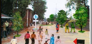
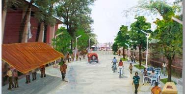
18 4.2 Gazipur Pilot Project The road segment selected for the second pilot site is called Hospital Road and connects the Gazipur pourashava (local government office) with the Joydebpur Railway station and the last BRT station. This site was chosen because it is visited frequently by a variety of officials, decision makers, and local residents. This area also sees heavy foot traffic by garment factory workers and other lowincome people. The current Gazipur mayor also showed great enthusiasm to improve the pedestrian environment in this area. Despite the area s low level of motorized traffic and high pedestrian volume, there are few amenities to facilitate walking and the roads are unsafe and unattractive. The street is too narrow to accommodate both footpaths and vehicles. Although space is available for other amenities, there are no trees, public toilets, street lights, seating arrangements, or trash cans. Significant space is also occupied in a haphazard fashion for parking by human haulers and rickshaw drivers. These factors affect those who walk, as well as those whose transit access and egress involves walking. The recommendations made for this pilot site are very similar to those noted above for the Uttara pilot project, and are not repeated here. However, the following preliminary before after artistic renderings are meant to illustrate the possible changes which would follow the implementation of the pilot project. Before implementation, the viewpoints of local residents will need to be solicited to improve the likelihood of project success. Figure 19: Before after artistic renderings of Gazipur pilot design Before After Dhaka s BRT Walkability Strategy Page 15


19 Dhaka s BRT Walkability Strategy Page 16
20 4.3 Recommendations Based on the pilot project objectives, the following action items are recommended. Table 3: Overview of issues addressed, research findings, and recommendations Issue Observation study Perception survey /FGD Road 6.5% of roads were under n/a construction construction Motorized traffic volume Low: 54% High: 15% No road present: 9% Land use mix Most segments had little (48%) or no (36%) land use mix Land use specifics type of land use Footpath availability Footpath composition and quality Footpath obstructions Footpath obstructions, type Residences: 85% Shops: 58% Offices: 24% Schools: 17% Parks/playgrounds: 2% Entertainment: 1% Both sides of street: 37% One side of street: 19% No footpath: 44% Dirt & sand: 55% Smooth: 18% Broken/uneven: 82% Free of obstruction: 15% Many obstructions: 16% Had to leave footpath due to obstruction: 65% of segments Car exit/entry cuts: 52% Shop goods: 42% Dhaka s BRT Walkability Strategy Page 17 n/a n/a Desired destination too far to walk: 38% Want to walk to entertainment or to park: 37% 39% of respondents could not walk where they wanted to because there was no footpath Very bad: 79% OK: 17% Good: 4% 31% of those surveyed had recently been injured while walking. 53% of respondents said that it is a priority to remove obstructions Recommendation Provide walkways or signs during maintenance/construction periods. Improvements to the pedestrian environment should be included in all road construction projects. Prioritize improvements to footpath availability on all high and medium motorized traffic volume roads. Make streets with little motorized traffic either free of motorized vehicles or pedestrian priority streets. Land use mix should be increased to make walking more viable. Increased neighbourhood diversity, especially neglected aspects like parks/playgrounds, should be prioritized. High volume roads should have footpaths on both sides of the road. Medium volume traffic roads should have a footpath on at least one side of the road. Dirt or sand footpaths should be upgraded to brick or concrete. Footpaths should be made smoother and more level. Footpaths must be kept free of obstruction. Policies to prevent obstructions on footpaths should be established and enforced, with fines for violators.
21 Issue Observation study Perception survey /FGD Cars/motorbike: 39% from footpaths. Rubbish: 39% Pillars/cables: 25% Vendors: 22% Trash cans: 16% Trees: 14% Trucks: 8% Much disorder: 34% Little disorder: 15% Footpath disorder, quantity Footpath disorder, types Street crossing barriers Street crossing facilities Cigarette/bidi butts: 92% Cans/bottles: 58% Garbage: 58% Graffiti: 28% Urine smell: 16% Broken glass: 16% Mixed traffic: 46% High median: 7% More than 2 lanes: 4% Barbed wire: 3% Trees/plantings: 3% Special lights: 16% Wheelchair accessible: 4% Curb cuts: 3% Cars obey the laws or yield to pedestrians: 1.3% Police enforcement: 1% Signs: 0.6% FOB or underpass: 0.2% Zebra crossing: 0.1% No crossing safety: 97% 58% of respondents mentioned cleaner footpaths as a priority concern More and safer crossings were a high priority for 75% of respondents. 48% feared crossing the road Desires of perception survey respondents Better police enforcement: 30% FOBs: 28% Zebra crossings: 26% FOBs as a serious obstacle for women and the elderly Recommendation Vendors should not be targeted for removal; they are a minor source of obstruction and make a positive contribution to the pedestrian environment. Regular cleaning of footpaths is needed. Foot over bridges (FOBs) should not be used as a solution; they are a serious obstacle to pedestrian movement and are unlikely to improve traffic flow. Instead, the number of zebra crossings should be increased, with attention to enforcement. Dhaka s BRT Walkability Strategy Page 18
22 Issue Observation study Perception survey /FGD Aggressive Aggressive drivers speeding or Motorized vehicles a drivers not giving pedestrians the right major source of fear for of way: 51% of roads pedestrians: more than 75%. Traffic calming No traffic calming: 93% Lane width restriction: 16% Speed humps: 5.5% Signs: 1% Traffic signals: 0.4% Roundabout: 0.2% Service amenities Lighting Vehicle parking Tree shade: 38% Vendors: 20% Seating: 1.4% Trash bins: 0.9% Toilet: 0.1% None: 79% Lighting from surrounding buildings: 73% Road oriented: 67% Pedestrian oriented: 3% None: 8% Cars and motorbikes illegally parked: 45% of roads Trucks illegally parked: 11% Legal, on street parking for cars/motorbikes: 4% Top priority of surveyed pedestrians is reducing and slowing traffic: 79% n/a Lack of adequate lighting causes pedestrians to be afraid of being robbed: 50% Sexual harassment was identified as a serious issue by FGD participants. n/a Recommendation Buses should run in dedicated lanes only. City should establish and enforce speed limits of 30 km/hour. Measures to reduce speed should be implemented. This is one of the most powerful instruments to reduce road trauma. Investments made to calm traffic are considered highly cost effective and would prove very popular. Service amenities are lacking and should be increased. Pedestrian oriented lighting should be increased, as it prevents both crime and injury. Illegal parking should be monitored and fines enforced Limited legal paid on road parking should be permitted to provide a buffer between pedestrians and moving traffic. Dhaka s BRT Walkability Strategy Page 19
23 5 Conclusions Until pedestrians are treated as valuable and a significant part of traffic, measures to improve their conditions will not prove successful. To ensure that ADB s Bus Rapid Transit (BRT) corridor would not only improve the growing traffic problems in Dhaka but also address the needs of pedestrians, this report presents a BRT Walkability Strategy which provides policy and infrastructure recommendations aimed at creating an environment in which walking is an appealing, safe, and convenient experience for people along the BRT corridor. The Strategy can be used as a model for other neighbourhoods in Dhaka, as well as for other cities throughout Bangladesh, to assist decision makers as they strive to create safer and more convenient pedestrian friendly transportation options. The recommendations included in the Strategy are based on the results of primary and desk top research, as well as extensive discussions with both policy makers and citizens. By , pedestrians accounted for 86% of road fatalities. The observational study of Dhaka s walking environment revealed that almost half of the observed streets had no footpaths and, where there were footpaths, less than one fifth were of sufficiently good quality to be safely useable. Pedestrians also face significant challenges in crossing streets and virtually all of the roads observed during the study were inhospitable for people living with disabilities. Pedestrian surveys and focus group discussions corroborated the findings of the observational study, highlighting that in spite of the desire or need to walk from one destination to another, few people in Dhaka are able to do so safely or conveniently. An improved environment for pedestrians would, in addition to being a precondition for making the BRT feasible, generate a broader positive change not only terms in enabling people to reach their destinations safely, affordably and conveniently, but also by improving traffic flow and creating a more congenial living environment. Current challenges to the creation of a pedestrian friendly environment include a weak policy framework, an unsupportive infrastructure, and a transportation environment that is more focused on cars than on people. There is, however, tremendous opportunity for Dhaka s residents to demand improved pedestrian conditions and for the city s decision makers to show real leadership and make investments in pedestrian friendly environments. This leadership is already being shown in some areas, as evidenced by the support given to the proposed pilot projects. The report provides a series of action based recommendations related to policy, law, government structures, infrastructure, maintenance, and implementation. No single measure will be sufficient to improve the condition of pedestrians in Dhaka to the point where walking can become a popular mode of transport. Given the wide range of issues that must be addressed, a broad and integrated approach is needed. These recommendations have thus been integrated into two proposed pilot projects which, if implemented, will showcase the design upgrades that can be made in Dhaka to improve the pedestrian environment while still supporting other modes of transport. Pedestrians are of vital importance to a city and yet face many obstacles to their safe, easy and convenient movement. Those problems cannot be adequately addressed without first giving pedestrians priority within urban and transport planning. Until this happens, their situation will not improve. The BRT Walkability Strategy provides the framework within which a pedestrian friendly city that values walking can be created. The strategy includes drafting, passing, and implementing a pedestrian first policy that recognizes the importance of walking to the city, to health, to economics, and to the environment. Dhaka s BRT Walkability Strategy Page 20
Traffic Congestion and Mismanagement in Dhaka City
 Traffic Congestion and Mismanagement in Dhaka City Md. Mamun Chowdhury Asst. Urban Planner, Building For Future Ltd. & Research Associate, FPD E-mail: mamun_buet@yahoo.com Traffic congestion is one of
Active Transportation Infrastructure Investment A Business Case
 Active Transportation Infrastructure Investment A Business Case In 2016, the Real Estate Foundation awarded the Capital Regional District a $50,000 grant for Shifting Gears: Land Use Change through Active
PEDESTRIAN ACTION PLAN
 ATTACHMENT 2 CITY OF SANTA MONICA PEDESTRIAN ACTION PLAN CITY OF SANTA MONICA PEDESTRIAN ACTION PLAN This page intentionally left blank EXECUTIVE SUMMARY CHAPTER 1 EXECUTIVE SUMMARY Setting the Stage
Agenda. Overview PRINCE GEORGE S PLAZA METRO AREA PEDESTRIAN PLAN
 PRINCE GEORGE S PLAZA METRO AREA PEDESTRIAN PLAN May 28, 2008 Agenda Welcome and introductions Project overview and issue identification Planning context and strengths Design challenges and initial recommendations
PRINCE GEORGE S PLAZA METRO AREA PEDESTRIAN PLAN
 PRINCE GEORGE S PLAZA METRO AREA PEDESTRIAN PLAN May 28, 2008 Agenda Welcome and introductions Project overview and issue identification Planning context and strengths Design challenges and initial recommendations
Proposed. City of Grand Junction Complete Streets Policy. Exhibit 10
 Proposed City of Grand Junction Complete Streets Policy Exhibit 10 1 City of Grand Junction Complete Streets Policy Vision: The Complete Streets Vision is to develop a safe, efficient, and reliable travel
FAQ s Walsh Road / Ferguson Road Pilot Scheme
 FAQ s Walsh Road / Ferguson Road Pilot Scheme What is happening? Traffic calming measures are being installed as a pilot. Temporary Bollards will be installed to the east of 1 Ferguson Road and a Temporary
Perryville TOD and Greenway Plan
 Perryville TOD and Greenway Plan Greenway Glossary Pathway: A bicycle and pedestrian path separated from motorized vehicular traffic by an open space, barrier or curb. Multi-use paths may be within the
Tonight is for you. Learn everything you can. Share all your ideas.
 Strathcona Neighbourhood Renewal Draft Concept Design Tonight is for you. Learn everything you can. Share all your ideas. What is Neighbourhood Renewal? Creating a design with you for your neighbourhood.
POLICY: TRAFFIC CALMING
 2006 MAY REFERENCE: COUNCIL APPROVED BY COUNCIL MAY 23, 2006 CITY OPERATIONS - NO. 608 POLICY: TRAFFIC CALMING A. All requests for traffic calming within the City shall be considered in accordance with
Transportation Master Plan Advisory Task Force
 Transportation Master Plan Advisory Task Force Network Alternatives & Phasing Strategy February 2016 BACKGROUND Table of Contents BACKGROUND Purpose & Introduction 2 Linking the TMP to Key Council Approved
Chapter 5. Complete Streets and Walkable Communities.
 Chapter 5. Complete Streets and Walkable Communities. 5.1 Description of Complete Streets. Cities throughout the world, and specifically the United States, are coming to embrace a new transportation and
CONNECTING PEOPLE TO PLACES
 CONNECTING PEOPLE TO PLACES 82 EAST BENCH MASTER PLAN 07 Introduction The East Bench transportation system is a collection of slow moving, treelined residential streets and major arteries that are the
Living Streets Policy
 Living Streets Policy Introduction Living streets balance the needs of motorists, bicyclists, pedestrians and transit riders in ways that promote safety and convenience, enhance community identity, create
2. Context. Existing framework. The context. The challenge. Transport Strategy
 Transport Strategy Providing quality connections Contents 1. Introduction 2. Context 3. Long-term direction 4. Three-year priorities 5. Strategy tree Wellington City Council July 2006 1. Introduction Wellington
5. Pedestrian System. Accomplishments Over the Past Five Years
 5. Pedestrian System Accomplishments Over the Past Five Years The Alamo Area Metropolitan Planning Organization (MPO) and its partner agencies recognize the importance of improving pedestrian mobility.
City of Toronto Complete Streets Guidelines
 Round One This is a summary of the Complete Streets Guidelines Survey posted on June 18 th, 2015 and live until July 2 nd, 2015. The survey was designed to solicit feedback on the draft Complete Streets
Urban Street Design and Development
 Urban Street Design and Development Ashok Bhattacharjee, Advisor, Clean Air and Sustainable Mobility, Centre for Science and Environment CSE Workshop on Safe Access and Parking - Lytton Hotel, Kolkata
REGIONAL BICYCLE AND PEDESTRIAN DESIGN GUIDELINES
 REGIONAL BICYCLE AND PEDESTRIAN DESIGN GUIDELINES November 16, 2011 Deb Humphreys North Central Texas Council of Governments Bicycle and Pedestrian Advisory Committee Snapshot of the Guide 1. Introduction
TOWN OF PORTLAND, CONNECTICUT COMPLETE STREETS POLICY
 TOWN OF PORTLAND, CONNECTICUT COMPLETE STREETS POLICY I. VISION, GOALS & PRINCIPLES VISION To improve the streets of Portland making them safer and more accessible for all users including pedestrians,
POLICY AGENDA For Elder Pedestrian Safety
 POLICY AGENDA For Elder Pedestrian Safety Older adults and people with disabilities often have mobility, cognitive, and sensory limitations that affect their behavior as pedestrians and place them at risk
Exhibit 1 PLANNING COMMISSION AGENDA ITEM
 Exhibit 1 PLANNING COMMISSION AGENDA ITEM Project Name: Grand Junction Circulation Plan Grand Junction Complete Streets Policy Applicant: City of Grand Junction Representative: David Thornton Address:
WALKNBIKE DRAFT PLAN NASHVILLE, TENNESSEE EXECUTIVE SUMMARY NASHVILLE, TENNESSEE
 NASHVILLE, TENNESSEE EXECUTIVE SUMMARY Executive Summary A world-class multi-modal transportation system is essential to a vibrant city and better quality of life. -Mayor Barry The WalknBike plan aims
CITY OF BLOOMINGTON COMPLETE STREETS POLICY
 CITY OF BLOOMINGTON COMPLETE STREETS POLICY POLICY OBJECTIVE: The City of Bloomington will enhance safety, mobility, accessibility and convenience for transportation network users of all ages and abilities,
NATIONAL ACTION STRATEGY A VOICE FOR WALKING
 NATIONAL ACTION STRATEGY A VOICE FOR WALKING Canadians are coming together to create a unified voice for walking and to pick up the pace of action for walkable communities. Our goal: to restore everyday
AMATS Complete Streets Policy
 AMATS Complete Streets Policy Table of Contents: Section 1. Definition of Complete Streets Section 2. Principles of Complete Streets Section 3. Complete Streets Policy Section 4. Consistency Section 5.
NM-POLICY 1: Improve service levels, participation, and options for non-motorized transportation modes throughout the County.
 Transportation PRINCE WILLIAM COUNTY 2008 COMPREHENSIVE PLAN NON-MOTORIZED PLAN CONTENTS Goals, Policies, and Action Strategies Table 4 (Bike Facility Classifications and Descriptions) Table 5 (Bike Facility
RESOLUTION NO ?? A RESOLUTION OF THE CITY OF NEPTUNE BEACH ADOPTING A COMPLETE STREETS POLICY
 RESOLUTION NO. 2018-?? A RESOLUTION OF THE CITY OF NEPTUNE BEACH ADOPTING A COMPLETE STREETS POLICY WHEREAS, safe, convenient, and accessible transportation for all users is a priority of the City of Neptune
Circulation in Elk Grove includes: Motor vehicles, including cars and trucks
 Circulation, as it is used in this General Plan, refers to the many ways people and goods move from place to place in Elk Grove and the region. Circulation in Elk Grove includes: Motor vehicles, including
City of Novi Non-Motorized Master Plan 2011 Executive Summary
 City of Novi Non-Motorized Master Plan 2011 Executive Summary Prepared by: February 28, 2011 Why Plan? Encouraging healthy, active lifestyles through pathway and sidewalk connectivity has been a focus
EXECUTIVE SUMMARY. Vision
 Vision Walking and bicycling in Salt Lake City will be safe, convenient, comfortable, and viable transportation options that connect people to places, foster recreational and economic development opportunities,
WALK Friendly Communities: Creating Vibrant, Inclusive Places for People
 WALK Friendly Communities: Creating Vibrant, Inclusive Places for People Walkers are the indicator species for vibrant communities ~ Dr. Rodney Tolley, Director, Walk21 Imagine yourself walking safely
21.07 TRANSPORT CONNECTIVITY AND INFRASTRUCTURE
 21.07 TRANSPORT CONNECTIVITY AND INFRASTRUCTURE 21.07-1 Connectivity and Choice Transport connectivity and mode choice are critical to achieving productive, sustainable and socially just cities. Travel
Bicycle Master Plan Goals, Strategies, and Policies
 Bicycle Master Plan Goals, Strategies, and Policies Mobilizing 5 This chapter outlines the overarching goals, action statements, and action items Long Beach will take in order to achieve its vision of
Solana Beach Comprehensive Active Transportation Strategy (CATS)
") Solana Beach Comprehensive Active Transportation Strategy (CATS) 3.0 Goals & Policies The Solana Beach CATS goals and objectives outlined below were largely drawn from the Solana Beach Circulation Element
Solana Beach Comprehensive Active Transportation Strategy (CATS) 3.0 Goals & Policies The Solana Beach CATS goals and objectives outlined below were largely drawn from the Solana Beach Circulation Element
Complete Streets. Designing Streets for Everyone. Sarnia
 Complete Streets Designing Streets for Everyone Sarnia Complete Streets ~ Sarnia ~ 2018 Introduction Our City is made up of a network of streets that we use to go for a walk, cycle to work, drive to the
Bikeway action plan. Bicycle Friendly Community Workshop March 5, 2007 Rochester, MN
 Bikeway action plan Summary The was held on March 5, 2007 at the Rochester Mayo Civic Center. The workshop was hosted by Rochester-Olmsted County Planning Department in collaboration with the League of
Ormond & McKinnon Walks Response to Draft Glen Eira Community Plan
 Response to Draft Glen Eira Community Plan We would like to take this opportunity to thank Glen Eira City Council for the opportunity to comment on the Glen Eira Draft Community Plan. Below is an outline
APPENDIX A: Complete Streets Checklist DRAFT NOVEMBER 2016
 APPENDIX A: Complete Streets Checklist DRAFT NOVEMBER 2016 Complete Streets Checklist MetroPlan Orlando s Complete Streets Checklist is an internal planning tool for staff to further implementation of
In station areas, new pedestrian links can increase network connectivity and provide direct access to stations.
 The Last Mile Planning for Pedestrians Planning around stations will put pedestrians first. Making walking to stations safe and easy is important; walking will be a part of every rapid transit Accessible
WALKABILITY SURVEY IN ASIAN CITIES
 WALKABILITY SURVEY IN ASIAN CITIES This section describes the methodology of the surveys for the benefit of the enumerators (surveyors) with some sample maps for illustration. The methodology for the survey
Governance and Priorities Committee Report For the July 2, 2015 Meeting
 CITY OF VICTORIA For the July 2, 2015 Meeting To: Governance and Priorities Committee Date: From: Subject: Brad Dellebuur, A/Assistant Director, Transportation and Parking Services Executive Summary The
PLANNING FOR SUSTAINABLE PEDESTRIAN INFRASTRUCTURE NALIN SINHA INITIATIVE FOR TRANSPORTATION & DEVELOPMENT PROG. (ITD), DELHI
, DELHI") PLANNING FOR SUSTAINABLE PEDESTRIAN INFRASTRUCTURE NALIN SINHA INITIATIVE FOR TRANSPORTATION & DEVELOPMENT PROG. (ITD), DELHI India s Road Network 5 million kms: Total road length 2.6 mn kms: Surfaced
PLANNING FOR SUSTAINABLE PEDESTRIAN INFRASTRUCTURE NALIN SINHA INITIATIVE FOR TRANSPORTATION & DEVELOPMENT PROG. (ITD), DELHI India s Road Network 5 million kms: Total road length 2.6 mn kms: Surfaced
POLICY STATEMENT: VISION ZERO
 Overview of APBP Policy Statements POLICY STATEMENT: VISION ZERO The Association of Pedestrian and Bicycle Professionals (APBP) supports the community of professionals working to create more walkable,
How To Encourage More Efficient Transportation in Brazilian Cities
 How To Encourage More Efficient Transportation in Brazilian Cities Todd Litman Victoria Transport Policy Institute Presented Seminar on Discouraging The Use Of Cars São Paulo, Brazil 3 September 2013 Creating
LEA BRIDGE ROAD - A STREET FOR EVERYONE Public consultation document
 LEA BRIDGE ROAD - A STREET FOR EVERYONE Public consultation document TELL US Bakers Arms to Leyton Green Road (Section D, E, F) Leyton Green Road to Whipps Cross Roundabout (Section G) YOUR VIEWS www.enjoywalthamforest.co.uk
Executive Summary Route 30 Corridor Master Plan
 Route Corridor Master Plan Project Overview The Route Corridor Master Plan is a coordinated multimodal transportation and land use plan for the entire stretch of Route through East Whiteland Township,
DRAFT. Table of Contents. Background
 Douglas County Table of Contents Existing Infrastructure 86 Funding 89 Policy and Program Recommendations 90 Infrastructure Recommendations 92 Conclusion 95 Background Home to 4,500 residents and Baker
Kelowna On the Move. Pedestrian and Bicycle Master Plan
 Kelowna On the Move Pedestrian and Bicycle Master Plan Executive Summary April 2016 Purpose of the Plan The Pedestrian and Bicycle Master Plan identifies infrastructure, planning, and policy requirements
EXECUTIVE SUMMARY: TRANSIT-ORIENTED DEVELOPMENT IN SMITHS FALLS, ONTARIO; A COMPARISON BETWEEN TWO SITES
 EECUTIVE SUMMARY: TRANSIT-ORIENTED DEVELOPMENT IN SMITHS FALLS, ONTARIO; A COMPARISON BETWEEN TWO SITES Topic and Purpose In 2007, the Mayor of Ottawa s Task Force on Transportation suggested adding a
Purpose and Need. Chapter Introduction. 2.2 Project Purpose and Need Project Purpose Project Need
 Chapter 2 Purpose and Need 2.1 Introduction The El Camino Real Bus Rapid Transit (BRT) Project (Project) would make transit and other transportation improvements along a 17.6-mile segment of the El Camino
Chapter 2. Bellingham Bicycle Master Plan Chapter 2: Policies and Actions
 Chapter 2 Bellingham Bicycle Master Plan Chapter 2: Policies and Actions Chapter 2: Policies and Actions The Bicycle Master Plan provides a road map for making bicycling in Bellingham a viable transportation
Chapter 7. Transportation. Transportation Road Network Plan Transit Cyclists Pedestrians Multi-Use and Equestrian Trails
 Chapter 7 Transportation Transportation Road Network Plan Transit Cyclists Pedestrians Multi-Use and Equestrian Trails 7.1 TRANSPORTATION BACKGROUND The District of Maple Ridge faces a number of unique
This objective implies that all population groups should find walking appealing, and that it is made easier for them to walk more on a daily basis.
 Walking for life The Norwegian Walking Strategy Guro Berge Norwegian public Roads Administration "Walking for life" is the slogan for the National Walking Strategy that is now being formulated in Norway.
City of Elizabeth City Neighborhood Traffic Calming Policy and Guidelines
 City of Elizabeth City Neighborhood Traffic Calming Policy and Guidelines I. Purpose: The City of Elizabeth City is committed to ensure the overall safety and livability of residential neighborhoods. One
Welcome. Background. Goals. Vision
 Welcome The formal Public Information Centre (PIC) for the Transportation Master Plan How We GO will be held in early 2017. At that time we will present the recommended transportation system for Niagara
Off-road Trails. Guidance
 Off-road Trails Off-road trails are shared use paths located on an independent alignment that provide two-way travel for people walking, bicycling, and other non-motorized users. Trails specifically along
ACTIVE TRANSPORTATION
 ACTIVE TRANSPORTATION Mobility 2040 Supported Goals Improve the availability of transportation options for people and goods. Support travel efficiency measures and system enhancements targeted at congestion
Living Streets response to the Draft London Plan
 Living Streets response to the Draft London Plan Contents Living Streets response to the Draft London Plan... 1 About Living Streets... 2 Summary... 2 Consultation response... 3 Chapter 1: Planning London
DRAFT for a State Policy for Healthy Spaces and Places
 DRAFT for a State Policy for Healthy Spaces and Places 1 DRAFT State Policy for Healthy spaces and Places 1. Purpose To encourage the use and development of land that builds healthy communities through
CONNECTIVITY PLAN. Adopted December 5, 2017 City of Virginia Beach
 CONNECTIVITY PLAN Adopted December 5, 2017 City of Virginia Beach CONTENTS 1.0 Background & Purpose... 2 2.0 Existing Inventory & Analysis... 3 ViBe District Existing Walking Conditions... 4 3.0 ViBe District
Madison Urban Area and Dane County. Bicycle Transportation Plan Summary. September Introduction. Bicycle Plan Scope and Planning Process
 Bicycle Transportation Plan Summary Madison Urban Area and Dane County Introduction September 2000 Bicycling is an important mode of transportation in the Madison urban area and countywide that is available
INDICATORS ON STREET & NEIGHBOURHOOD LEVEL. Ryan Martinson Tim Pharoah
 INDICATORS ON STREET & NEIGHBOURHOOD LEVEL Ryan Martinson Tim Pharoah Why a difference between National/City and Street/Neighbourhood indicators? there are a variety of treatments there are a variety of
Introduction.
 2307-1.0. Introduction. Delaware s Safe Routes to School (SRTS) Program was established September 10, 2002 when Governor Ruth Ann Minner signed Senate Bill 353 of the 141st General Assembly of Delaware
Launceston's Transport Futures. Greater travel options for the people of Launceston
 Launceston's Transport Futures Greater travel options for the people of Launceston Final Draft 13 Jan 2014 1 Page Number Executive summary 3 What is Transport Futures? 4 Vision 6 Economy, access and liveability
Active Transportation Facility Glossary
 Active Transportation Facility Glossary This document defines different active transportation facilities and suggests appropriate corridor types. Click on a facility type to jump to its definition. Bike
SAN FRANCISCO MUNICIPAL TRANSPORTATION AGENCY
 THIS PRINT COVERS CALENDAR ITEM NO. : 10.2 DIVISION: Sustainable Streets BRIEF DESCRIPTION: SAN FRANCISCO MUNICIPAL TRANSPORTATION AGENCY Adopting Conceptual Proposal for Streetscape Improvements to Broadway,
Implementing Complete Streets in Ottawa. Project Delivery Process and Tools Complete Streets Forum 2015 October 1, 2015
 Implementing Complete Streets in Ottawa October 1, 2015 The Essentials Complete Streets Implementation Framework will become part of the routine delivery of City transportation projects Approach uses every
Toronto Complete Streets Guidelines
 88 90 5.1 Cycling Design Principles 92 5.2 Context-sensitive Cycling Facilities 96 5.3 Key Cycling Elements Cycling infrastructure provides choice in how people are able to move around the city. Cyclists
CITY OF SAINT JOHN TRAFFIC CALMING POLICY
 CITY OF SAINT JOHN TRAFFIC CALMING POLICY VERSION: 1.0 April 10, 2012 Pedestrians, Cyclists and Motorists Sharing Street Spaces CONTENTS INTRODUCTION... 3 POLICY GOAL... 3 POLICY OBJECTIVES... 3 GUIDING
IMPROVED SAFETY SURFACE ACCESS AT LOW COST AIRPORTS: KUALA LUMPUR INTERNATIONAL AIRPORT, MALAYSIA CASE STUDY
 IMPROVED SAFETY SURFACE ACCESS AT LOW COST AIRPORTS: KUALA LUMPUR INTERNATIONAL AIRPORT, MALAYSIA CASE STUDY Rohafiz Sabar, Mustakim Melan, Nur Khairiel Anuar Universiti Utara Malaysia Transport and Logistics
Welcome! Public Open House on UBC s Transportation Plan
 1 Welcome! Public Open House on UBC s Transportation Plan Public open house hours: to When it comes to on-campus transportation, what do you think is working well and what are some opportunities for improvement?
NASHUA REGIONAL PLANNING COMMISSION REGIONAL BICYCLE AND PEDESTRIAN PLAN
 NASHUA REGIONAL PLANNING COMMISSION REGIONAL BICYCLE AND PEDESTRIAN PLAN June, 2005 Prepared by the Nashua Regional Planning Commission 2005 NRPC Regional Bicycle and Pedestrian Plan- JUNE 2005 ACKNOWLEDGEMENTS
WILMAPCO Public Opinion Survey Summary of Results
 Wilmington Area Planning Council WILMAPCO Public Opinion Survey Summary of Results Prepared by: 2955 Valmont Road, Suite 300 Boulder, Colorado 80301 t: 303-444-7863 f: 303-444-1145 www.n-r-c.com Table
Film Guide for Educators. Designing for Safety
 Film Guide for Educators Designing for Safety Designing For Safety Key Concepts Speeding While Driving Speeding is the number one cause of injuries and deaths from driving. The main reasons are because
Corpus Christi Metropolitan Transportation Plan Fiscal Year Introduction:
 Introduction: The Safe, Accountable, Flexible, Efficient Transportation Equity Act: A Legacy for Users (SAFETEA-LU) has continued the efforts started through the Intermodal Surface Transportation Efficiency
CHAPTER 3: Vision Statement and Goals
 Davidson Walks & Rolls: Active Transportation Master Plan CHAPTER 3 Contents: Overview Vision Statement Measurable Goals Public Outreach CHAPTER 3: Vision Statement and Goals Overview The vision statement
Douglas Land Use and Transportation Strategy (DLUTS) Summary. August 2013
 Summary. August 2013") Douglas Land Use and Transportation Strategy (DLUTS) Summary August 2013 Background Douglas is a large and popular residential suburb of approximately 30,000 persons on the periphery of Cork City along
Douglas Land Use and Transportation Strategy (DLUTS) Summary August 2013 Background Douglas is a large and popular residential suburb of approximately 30,000 persons on the periphery of Cork City along
complete streets design and construction standards public primer City of Edmonton
 complete streets design and construction standards public primer City of Edmonton introduction Complete Streets are streets for everyone: people who walk, wheel, bike, take transit, or drive. They are
2014/2015 BIKE ROUTE PLAN 83 AVENUE PROTECTED BIKE LANE
 About the Project 2014/2015 BIKE ROUTE PLAN The City of Edmonton is planning a major bike route on the south side of Edmonton. This bike route is one part of a plan to provide citizens with transportation
Chapter 5 Future Transportation
 Chapter 5 Future Transportation The Future Land Use Plan identifies the desired land use designations. The land uses desired for Crozet depend, in large part, on the success of the transportation system,
University of Victoria Campus Cycling Plan Terms of Reference. 1.0 Project Description
 University of Victoria Campus Cycling Plan Terms of Reference 1.0 Project Description The Campus Cycling Plan, a first for the University, will provide a comprehensive and coordinated approach to support
STONY PLAIN ROAD STREETSCAPE
 Jasper Place Revitalization Strategy: Vision The people involved in the Jasper Place Revitalization Strategy envision: Goal 1: Feeling safe in our community Create a community where feeling safe is common--where
Second UN Global Road Safety Week. Pedestrian Safety. A toolkit for organizers of events
 Second UN Global Road Safety Week Pedestrian Safety A toolkit for organizers of events This toolkit for organizers is intended as a guide to help plan activities and events during the Second UN Global
Goal 3: Foster an environment of partnerships and collaboration to connect our communities and regions to one another.
 Non-Motorized Transportation Plan (NMTP) Draft Vision, Goal and,, Tri-County Regional Planning Commission (TCRPC) Purpose The purpose of the Tri-County Regional Planning Commission (TCRPC) Non-Motorized
Comments EXECUTIVE SUMMARY
 Comments 1. Under any Alternatives, MCDOT should provide better at-grade pedestrian crossing of Georgia Avenue and Forest Glen Road, including improved crosswalks with wider medians and adequate signal
Complete Streets for Niagara A working method to visualize the creation of a complete street June 20th, 2013
 Complete Streets for Niagara A working method to visualize the creation of a complete street June 20th, 2013 C O N T E N T S Introduction and background of the report What is a complete street? What can
Streets. Safe for Pedestrians 20% 2nd 5,000. Are We People-Friendly?
 Streets Safe for Pedestrians 20% Pedestrian deaths account for more than of all traffic-related fatalities in California each year. 600 More than people are killed and another 13,000 are injured every
Baseline Survey of New Zealanders' Attitudes and Behaviours towards Cycling in Urban Settings
 Baseline Survey of New Zealanders' Attitudes and Behaviours towards Cycling in Urban Settings Highlights 67% of urban New Zealanders, 18 years of age or more own or have access to a bicycle that is in
Footpath design. A guide to creating footpaths that are safe, comfortable, and easy to use
 Footpath design A guide to creating footpaths that are safe, comfortable, and easy to use November 2013 Contents Introduction / 1 Zoning system / 2 Width / 4 Height / 5 Surface / 5 Footpath elements /
Transportation Assessment
 Transportation Assessment Midtown Open House February 10, 2018 Overview Midtown in Focus Overview & Purpose of Today Transportation Assessment overview Summary of Transportation work to date Review & Analysis
INDOT Complete Streets Guideline & Policy
 INDOT Complete Streets Guideline & Policy INTRODUCTION The Complete Streets guidelines build upon multiple efforts and promote a multimodal transportation system that is integrated and sustains land use
Creating walkable, bikeable and transit-supportive communities in Halton
 Creating walkable, bikeable and transit-supportive communities in Halton By presenting current research and best practices, the information in this paper is meant to support and broaden discussion on how
PEDALING FORWARD. A Glance at the SFMTA s Bike Program for SFMTA.COM
 PEDALING FORWARD A Glance at the SFMTA s Bike Program for 2017-2021 SFMTA.COM INTRODUCTION About This Booklet More people from all walks of life see their bicycle as a more convenient way to get where
HAMILTON BIKING PLAN OUR VISION: A BIKE FRIENDLY CITY
 HAMILTON BIKING PLAN 2015-2045 OUR VISION: A BIKE FRIENDLY CITY INTRODUCTION Biking as a travel option is experiencing a resurgence internationally and in New Zealand, growing as a familyfriendly and healthy
TRAVEL PLAN: CENTRAL EUROPEAN UNIVERSITY CAMPUS REDEVELOPMENT PROJECT TRAVEL PLAN. Central European University Campus Redevelopment Project.
 TRAVEL PLAN Central European University Campus Redevelopment Project Page 1 Table of Contents Introduction... 3 Background... 7 Building Users... 7 Transportation in Community Consultation... 7 Summary
summary of issues and opportunities
 1 summary of issues and opportunities EXECUTIVE SUMMARY CHAPTER 2: HISTORY - 3: LAND USE This first chapter is an overview of lessons learned from analysis of the existing conditions on El Camino as well
5 CIRCULATION AND STREET DESIGN
 5 CIRCULATION AND STREET DESIGN This chapter describes circulation and streetscape improvements proposed for the Northwest Chico Specific Plan Area. It includes detailed design specifications for existing
City of Birmingham Draft Multi-modal Transportation Plan
 City of Birmingham Draft Multi-modal Transportation Plan City Commission Public Hearing Monday, November 25, 2013 7:30 pm Norman Cox, PLA, ASLA The Greenway Collaborative, Inc. Ann Arbor, Michigan The
Governor s Transportation Vision Panel
 Office of Governor Kate Brown Governor s Transportation Vision Panel JLA Public Involvement Project Overview The is a yearlong effort to develop a series of recommendations for the Governor that address