ROAD SAFETY AUDIT. Centre Street (Route 123) at Plymouth Street. Municipality of Brockton. November, Prepared For: MassDOT
|
|
|
- Suzanna Dorsey
- 5 years ago
- Views:
Transcription

1 ROAD SAFETY AUDIT Centre Street (Route 123) at Plymouth Street Municipality of Brockton November, 2017 Prepared For: MassDOT On Behalf Of: City of Brockton Prepared By: Old Colony Planning Council 70 School Street, Brockton, MA 02301
2 Road Safety Audit Centre Street (Route 123)/Plymouth Street Intersection - Brockton Prepared by Old Colony Planning Council Table of Contents Contents Background... 1 Project Data... 1 Project Location and Description... 2 Crash Details and Overview... 4 Audit Observations and Potential Safety Enhancements... 4 Summary of Road Safety Audit... 9 List of Appendices Appendix A. Appendix B. Appendix C. Appendix D. Appendix E. RSA Meeting Agenda RSA Audit Team Contact List Detailed Crash Data Additional Information Road Safety Audit References List of Figures Figure 1: Locus Map... 3 List of Tables Table 1: Participating Audit Team Members... 2 Table 2: Estimated Time Frame and Costs Breakdown Table 3: Potential Safety Enhancement Summary... 11
3 Road Safety Audit Centre Street (Route 123)/Plymouth Street Intersection - Brockton Prepared by Old Colony Planning Council Background This Road Safety Audit (RSA) was conducted by the Old Colony Planning Council, (OCPC), at the request of the City of Brockton. The City submitted a Project Notification Form (PNF) in January of 2017 to MassDOT. The primary goal according to the PNF was, to improve safety and pedestrian accommodation at an intersection with a high crash rate. The PNF states that Centre St (Route 123) is a primary connection between downtown Brockton and the adjacent towns of Abington and Rockland, while also serving to connect downtown Brockton with residential neighborhoods on the east side, and amenities such as Brockton Hospital. It functions both as a through road linking Brockton to adjacent towns and as a local street, lined with homes and businesses. The PNF stated that the intersection experiences long delays and congestion, especially during the morning and afternoon peak hours. The traffic flow on the major road, Centre Street (Route 123), is so heavy during the peak hours that side street traffic on minor street, Plymouth Street stop-controlled approaches has very few sufficient gaps in the major street traffic to make through or left and right turning movements. The LOS on the side street approaches are LOS F and characterized as forced flow. In addition, this intersection is included on MassDOT 2012 Statewide Top 200 Intersection Crash List. Centre Street (Route 123) to the immediate west of the intersection is included in a Highway Safety Improvement Program (HSIP) Top 5 percent Crash Clusters for the OCPC Region. Project Data The Road Safety Audit took place on Thursday, September 21, 2017 at the Brockton Area Transit office located at 155 Court Street, Brockton. The meeting was facilitated by OCPC staff. OCPC provided a collision diagram and the latest three year crash experience based on crash reports provided by the Brockton Police Department. In addition, OCPC provided morning and afternoon turning movement counts (which included pedestrian counts), and signal warrant analysis reports. The meeting consisted of three components. The first portion of the meeting focused on a discussion of the issues and concerns. The participants left the BAT meeting room and walked to the intersection to visit the site for the second portion of the meeting. The discussion of issues was continued during the site visit as OCPC staff took notes. The third portion of the meeting focused on potential short term and long term potential improvements for the intersection. The agenda and the background materials are included in the appendix to this report. Table 1 lists the names and affiliations of the audit participants. Page 1
4 Road Safety Audit Centre Street (Route 123)/Plymouth Street Intersection - Brockton Prepared by Old Colony Planning Council Table 1: Participating Audit Team Members Audit Team Member Agency/Affiliation Elsa Chan Kevin Fitzgerald MassDOT Traffic Safety MassDOT Traffic Safety Bianca Marshall MassDOT District 5 Chike Odunukwe Nilton DePirla Ken Thompson Kelly Forrester Jason Walters James Donovan Dan Murphy Ray Ledoux Bill McNulty Kyle Mowatt Raymond Guarino City of Brockton Department of Public Works Brockton Fire Department Signal Division Brockton Public Schools Brockton Area Transit MassDOT District 5 Projects Brockton Fire Department Signal Division CDM Smith Brockton Area Transit Old Colony Planning Council Old Colony Planning Council Old Colony Planning Council Project Location and Description The Centre Street (Route 123)/Plymouth Street intersection is a four-way intersection (stop-controlled on the Plymouth Street northbound and southbound minor street approaches), located in Brockton downtown just east of the Brockton Area Transit (BAT) Centre. A flashing beacon is provided overhead via mast arm, with flashing red on the Plymouth Street stop approaches and yellow on the Centre Street (Route 123) approaches. The BAT Centre and BAT Parking Garage are about 600 feet to the west at Centre Street and Commercial Street. Trout Brook runs parallel to Plymouth Street to the east of the intersection and beneath Centre Street (Route 123). There are two playgrounds off of Centre Street to the east of the intersection, Snow Park on the south side of Centre Street and the O Donnell playground on the north side of Centre Street across from Snow Park. The Salvation Army is located near to the intersection, (east of Plymouth Street across from Trout Brook). The Crescent Court Apartments, a residential development, is located on Plymouth Street, southwest of the intersection. Centre Street (Route 123) is functionally classified as an Urban Principal Arterial in Brockton, and is under Brockton jurisdiction at its intersection with Plymouth Street. The speed limit is not posted on Centre Street (Route 123) in the immediate vicinity. Centre Street is part of the NHS System. Plymouth Street is an urban minor arterial that functions as a bypass between Court Street and Crescent Street (Route 27), with the Plouffe School located at the corner of Crescent Street (Route 27) and Plymouth Street. Although the minor street northbound and southbound Plymouth Street approaches provide one shared through, left turn, and right turn lane, both of these approaches are wide enough so that a de-facto right turn lane occurs as vehicles turning right go around vehicles waiting to turn left. The Centre Street (Route 123) westbound approach into the intersection (over the brook) provides a single shared right turn, through, and left turn lane. The Centre Street (Route 123) eastbound approach into the intersection Page 2

5 Road Safety Audit Centre Street (Route 123)/Plymouth Street Intersection - Brockton Prepared by Old Colony Planning Council provides a shared through left turn lane and an exclusive right turn lane. This eastbound approach has a four lane cross-section and is approximately 65 feet in width, which presents a long, hazardous crossing for pedestrians. There are four twelve foot lanes plus two eight foot shoulders used for parking on Centre Street (Route 123) west of the intersection. Some motorists use the south side of the eastbound Centre Street approach for commuter rail parking. The time restrictions are posted across from the BAT Parking Garage near Commercial Street, but are not posted on Centre Street (Route 123) near the Centre Street (Route 123)/Plymouth Street intersection (near the Crescent Court Apartments). In addition, some motorists park on the west side of Plymouth Street (southbound direction), near the Crescent Court Apartments, south of the intersection, which also provides an eight foot shoulder. Figure 1 shows the location of the intersection. Figure 1: Locus Map BAT Intermodal Centre BAT Parking Garage Crescent Court Apartments Crash data for the Centre Street (Route 123)/Plymouth Street intersection was obtained from the Brockton Police Department for the latest available three-year period ( ). The data was analyzed by Page 3
 in the Manual of Traffic Engineering Studies.")
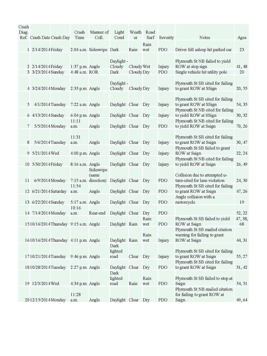
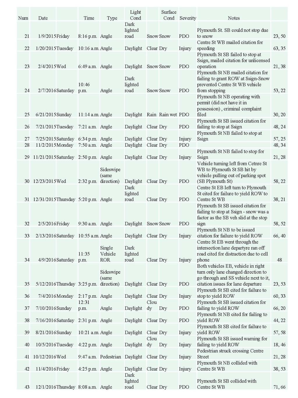
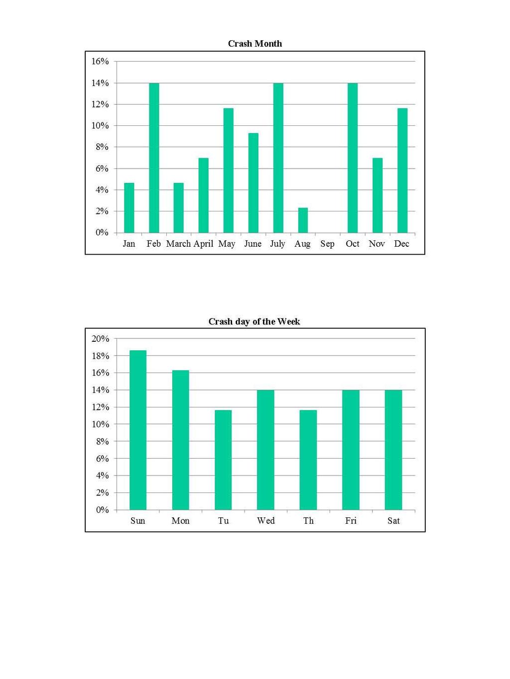
6 Road Safety Audit Centre Street (Route 123)/Plymouth Street Intersection - Brockton Prepared by Old Colony Planning Council OCPC in accordance with the standard practices published by the Institute of Transportation Engineers (ITE) in the Manual of Traffic Engineering Studies. Crash Details and Overview Crash reports were compiled from the Brockton Police Department for the years 2014, 2015, and There were a total of 43 crashes at the intersection within the three year study period. Eighty-one percent of the crashes (35 crashes) were angle type crashes, nine percent (four crashes) were side-swipe (same direction) crashes, five percent (two crashes) were single vehicle ran off the road type crashes, two percent (one crash) were rear-end, and two percent (one crash) involved a car hitting a pedestrian. Fortyeight percent of the crashes resulted in personal injury, while 52 percent resulted in property damage only. The majority of the crashes were spread out evenly during the day between 6 a.m. and 6 p.m. and occurred under daylight and dry conditions; however there were 14 percent or six crashes that occurred after dark and before 6 a.m. The intersection has a crash rate of 2.75 crashes per million entering vehicles. The MassDOT District 5 average for unsignalized intersections is 0.58 crashes per million entering vehicles. More detailed crash data is included in the Appendix. Audit Observations and Potential Safety Enhancements During the RSA meeting prior to the field visit, a brief introduction of the RSA process and a summary of traffic volumes and crash information were presented to the audit participants. Following this brief presentation, the members of the audit team were asked to discuss the existing issues that may affect safety at the intersection of Centre Street (Route 123) at Plymouth Street. The audit team then visited the site as a group, at which time observations, safety concerns, and deficiencies were identified and documented. Provided below is a list of the safety concerns and the potential enhancements that were identified during the RSA. Safety Issue: Lack of Sight Distance Due to Vegetation and Parked Vehicles Sight distance for vehicles approaching the intersection on Plymouth Street from the north as well as from the south is obscured by the presence of vegetation along the east side of the intersection parallel to Trout Brook and Plymouth Street. In addition, vehicles on the Plymouth Street northbound approaches have sight blocked due to parked cars along the west side of Plymouth Street and the south side of Centre Street (Route 123). Enhancements: Trim back the vegetation on the northeast and southeast corners of the intersection to improve sight lines and consider prohibiting parking by posting No Vegetation to the right of the photo (northeast corner) obscures sight distances for vehicles waiting at stop line on the southbound approach Page 4
 south side west of the intersection far enough back to prevent sight blockage.")
7 Road Safety Audit Centre Street (Route 123)/Plymouth Street Intersection - Brockton Prepared by Old Colony Planning Council Parking signs (R7-1) on Plymouth Street west side south of the intersection and on Centre Street (Route 123) south side west of the intersection far enough back to prevent sight blockage. Safety Issue: High Number of Angle Type Crashes This intersection experiences a higher number of angle type crashes crash than is expected for a stop controlled four-way intersection. A large portion of these crashes occurred when the southbound vehicle on Plymouth Street failed to yield right of way to an eastbound vehicle or westbound vehicle on Centre Street (Route 123). Enhancements: Add additional signage alerting Plymouth Street southbound drivers at the intersection that cross traffic does not stop. Safety Issue: Vehicle parking too close to the intersection Vehicles park on Centre Street (Route 123) along the south side of the street on the eastbound approach (in front of the housing complex) right up to the intersection. In addition, vehicles are parked too close to the intersection on Plymouth Street along the west side of the street (in front of the housing complex). The right turn radii is hindered for buses, heavy vehicles, and right turning traffic (Centre Street eastbound to Plymouth Street southbound) due to these parked cars and parking maneuvers along the west side of Plymouth Street and the south side of Centre Street (Route 123) hinder moving traffic. The parking enforcement is not done on a regular basis, and the posted time limit for parking is only posted in one location (across the street from the BAT Parking Garage). In addition, these parked cars close to the intersection hinder the sight distance for Plymouth Street northbound vehicles looking west. Enhancements: Limit parking and post No Parking on Plymouth Street west side south of the intersection and on Centre Street (Route 123) south side west of the intersection far enough back to prevent sight blockage. Parking along the south side of Centre Street (Route 123) west of the intersection and parking along Plymouth Street on the west side south of the intersection, should be limited to permit parking for residents in the housing complex. Safety Issue: The exclusive right turn lane on the Centre Street (Route 123) approach causes driver confusion. Vehicle parked too close to the intersection on the eastbound Centre Street (Route 123) approach. Vehicles on the Plymouth Street northbound approach stopped at the stop sign look at two lanes of approaching traffic on Centre Street eastbound. Confusion and collisions occur due to northbound traffic stopping for the Centre Street eastbound right turns to Plymouth Street but disregarding the Centre Street through movements which are sometimes behind the right turning vehicles and not seen by the Plymouth Street traffic. In addition, last minute lane changes by vehicles in the exclusive right turn lane to the Page 5

8 Road Safety Audit Centre Street (Route 123)/Plymouth Street Intersection - Brockton Prepared by Old Colony Planning Council through lane on the eastbound approach create safety hazards and result in side-swipes. There is a lack of warning signs on the eastbound approach warning vehicles that the right lane is for right turn only. Enhancement: Evaluate the need for the exclusive right turn lane on the Centre Street (Route 123) eastbound approach to the intersection. Consider implementing a road diet for Centre Street between Commercial Street and Plymouth Street, reducing the cross section from four lanes to two lanes. If the right turn lane is not removed, add advance warning that the lane is becoming a right turn only lane Safety Issue: Stop Sign Placement The view of the stop sign on the Plymouth Street southbound approach is blocked by other signs. Enhancement: Place stop signs on both sides of the road and relocate signs that block the stop signs. Consider adding additional stop-ahead signs on the southbound approach on the far side of the intersection as well as on the opposite side. Safety Issue: Stop Bar on the Centre Street Eastbound Approach The eastbound Centre Street approach has a stop bar painted on the street but there is no stop sign control on this approach (vehicles have the right of way) and the signal facing eastbound is flashing yellow. This could add to driver confusion. Enhancement: Remove the stop bar on the Centre Street eastbound approach. Safety Issue: Drainage Issues and Catch Basin Locations A catch basin is located in the crosswalk at the southwest corner of the intersection. In addition, there are signs of ponding at the base of the curb ramp. Enhancement: Evaluate existing drainage conditions and relocate the catch basin that is within the crosswalks and other catch basins if necessary to improve drainage. Safety Issue: Speeding Signs of ponding on the crosswalk RSA participants stated that they observed chronic speeding on Centre Street (Route 123), in the eastbound and westbound directions. Enhancement: The City should consider enhanced speed enforcement and electronic speed feedback signs. Page 6
9 Road Safety Audit Centre Street (Route 123)/Plymouth Street Intersection - Brockton Prepared by Old Colony Planning Council Safety Issue: Inadequate Lighting Street lights are present at the intersection; however, these might not be enough to provide adequate lighting for the intersection after dusk. There were nine crashes that occurred under non-daylight conditions. Enhancement: The City should consider conducting a lighting evaluation and increase the number of street lights if necessary. In addition, an upgrade of existing lighting to LED should be considered. Safety Issue: Lack of Bicycle Accommodations There are no bicycle accommodations on Centre Street (Route 123) or Plymouth Street, although both streets do have sufficient width for accommodations. There were bicycles observed passing through the intersection during the turning movement count. Enhancement: Consider providing bicycle accommodations per MassDOT s New Healthy Transportation initiative Policy. Consider implementing Complete Streets elements along Center Street and Plymouth Street. Enhancements may include shared or dedicated bike lanes, as well as bicycle detention, bike route signs, and pavement markings. Bicycle lanes should be added depending upon right of way availability, as Plymouth Street will maintain parking as well. Sharrows and signage can be used on the approaches that lack right of way width (in place of bicycle lanes). Travel lanes should consider sufficient width to accommodate buses and heavy vehicles. Safety Issue: Pedestrian Safety Crosswalks are provided across all four legs of the intersection. The longer crossing (west leg) is in excess of 60 feet with no pedestrian refuge. There is a lack of pedestrian accommodation across the four lane cross-section on Centre Street (Route 123) west of the intersection. Pedestrians often cross midblock in this section of Centre Street (Route 123), which is part of an HSIP Cluster for pedestrian crashes. The intersection experiences significant pedestrian activity as documented in the turning movement counts. In addition, there are crossing guards at the intersection when school (Joseph Plouffe Academy, located further south of the intersection) is in session. Audit participants also noted that pedestrians cross at unmarked crossing areas in front of the BAT Garage. Enhancement: Consider implementing Complete Streets elements. Consider implementing a road diet for Centre Street (Route 123) between Commercial Street and Plymouth Street, reducing the cross section from four lanes to two lanes. Consider adding pedestrian bump-outs thereby reducing the crossing length to decrease the amount of time that pedestrians are exposed in the intersection. Evaluate the feasibility of adding a mid-block crossing and a Rapid Rectangular Flashing Beacon (RRFD) within the section of Route 123 west of the intersection. Consider public outreach education on pedestrian safety partnering BAT and Brockton Schools. Safety Issue: ADA Ramps The curb ramps lack tactile warning tiles for sight impaired pedestrians. Page 7
10 Road Safety Audit Centre Street (Route 123)/Plymouth Street Intersection - Brockton Prepared by Old Colony Planning Council Enhancement: Upgrade all existing curb ramps to meet ADA compliance, including the addition of tactile warning tiles to provide warning for visually impaired pedestrians. This includes all locations at the intersection and any mid-block crossings. Safety Issue: Lack of Advanced Warning Audit participants cited a lack of advanced warning signs on the eastbound and westbound Centre Street (Route 123) approaches. Enhancement: Consider installing electronic messaging speed signs, and students crossing warning signs on the Centre Street (Route 123) eastbound and westbound approaches. Consider adding lane use signs on the Centre Street (Route 123) eastbound and westbound approaches. Safety Issue: Access Management There is a lack of access management at the intersection, which creates extra, unexpected cross movements close to the intersection, especially on the northwest corner of the intersection on Plymouth Street and Centre Street. This driveway is in close proximity to the intersection, while there are no related crashes, vehicles entering and exiting could potential introduce angle and courtesy crashes. Enhancement: Limit movements (right turn in and out) and/or eliminate curb cuts close to the intersection. Safety Issue: Guard Rail The guard rail on Centre Street, over Trout Brook, presents a danger to lane departure crashes with the potential to overturn vehicles, due to the buried end treatments. Enhancement: Consider replacing guardrail that meets MassDOT standards. Safety Issue: Intersection visibility The mast arm overhead flashing beacons at the intersection, which are flashing yellow facing Centre Street (Route 123) and flashing red facing Plymouth Street, could use more visibility for advanced warning. Enhancement: Consider updating Flashing Beacons to LED to improve signal visibility. Safety Issue: Congestion and Delays The intersection currently experiences poor levels of service (LOS F forced flow) during the morning and afternoon peak hours for the Plymouth Street northbound and southbound approach critical movements (through and left turns), based on existing peak hour level-of-service analysis completed by OCPC. There is a lack of gaps in the Centre Street (Route 123) peak hour traffic flows (eastbound and Page 8
11 Road Safety Audit Centre Street (Route 123)/Plymouth Street Intersection - Brockton Prepared by Old Colony Planning Council westbound) to allow vehicles to safely turn from the side street to Centre Street. Motorists get frustrated with the delays and force their way onto the Centre Street causing near misses and crashes. The intersection is slightly skewed, with a wide turning radius on the southbound approach. The turning radius on the southbound approach should be reduced. Enhancement: Install traffic signals at the intersection or construct a roundabout. Based on warrant analysis completed by OCPC, the intersection volumes satisfy Warrants 1, 2, and 3 of the Manual on Uniform Traffic Devices (MUTCD). In addition, the sum of the peak hour entering and circulating volumes at the intersection are well below 1,000, which indicates a single-lane roundabout would operate acceptable (based on the National Cooperative Highway Research Program s Report 672 Roundabouts an Informational Guide, FHWA). Traffic signals will include signal pre-emption for emergency vehicles and green time extension for BAT buses, as requested by the City of Brockton. Safety Issue: Plymouth Street Southbound Approach Lane Use (De-facto Right turn lane) Vehicles on the Plymouth Street southbound approach turning right from Plymouth Street to Centre Street (Route 123) will squeeze by queued vehicles waiting to continue on Plymouth Street or turning left to Centre Street (Route 123), (creating a de-facto right turn lane southbound). The right turn motorist cannot see adequately past the queued vehicles when doing this. The southbound Plymouth Street approach lane is not stripped as two lanes. Enhancement: Decreasing the right turn radius on the Plymouth Street southbound approach and narrowing the lane width would prevent the right turn vehicles from squeezing by queued vehicles on the southbound approach. Alternatively, a right turn lane can be added to allow this movement if the volumes demand it and the sight lines can be improved. Summary of Road Safety Audit Based on the review of data, on-site field observations and group discussion, the RSA team identified possible enhancements that could improve safety at the intersection of Centre Street (Route 123)/Plymouth Street in Brockton. Further study and design work will need to be conducted to determine the feasibility of making some of the improvements. Table 2 summarizes the estimated time frame and costs breakdown and Table 3 summarizes the safety issues, possible enhancements, estimated safety payoff, time frame, cost, and responsibility. Safety payoff estimates are based on engineering judgment and are categorized as low, medium, and high. The time frame is categorized as short-term (<1 year), midterm (1 to 3 years), or long-term (typically >3 years). Long-term improvements are typically considered to be substantial improvements with an expected time frame for implementation greater than 3 years. The costs are categorized as low (<$10,000), medium ($10,001 to $50,000), or high (>$50,000). Page 9
12 Road Safety Audit Centre Street (Route 123)/Plymouth Street Intersection - Brockton Prepared by Old Colony Planning Council Table 2: Estimated Time Frame and Costs Breakdown Time Frame Costs Short-Term <1 Year Low <$10,000 Mid-Term 1-3 Years Medium $10,001-$50,000 Long-Term >3 Years High >$50,000 Page 10
13 Road Safety Audit Centre Street (Route 123) at Plymouth Street, Brockton Prepared by Old Colony Planning Council Table 3: Potential Safety Enhancement Summary Safety Issue Potential Safety Enhancement Safety Payoff The sight distance for vehicles approaching the intersection on Plymouth Street from the north as well as from the south is obscured by the presence of vegetation along the east side of the intersection parallel to Trout Brook and Plymouth Street. Vehicles on the Plymouth Street northbound approaches have sight blocked due to parked cars along the west side of Plymouth Street and the south side of Centre Street (Route 123). This intersection experiences a higher number of angle type crashes crash than is expected for a stop controlled four-way intersection. A large portion of these crashes occurred when the southbound vehicle on Plymouth Street failed to yield right of way to an eastbound vehicle or westbound vehicle on Centre Street (Route 123). Vehicles park on Centre Street (Route 123) along the south side of the street on the eastbound approach (in front of the housing complex) right up to the intersection. In addition, vehicles are parked too close to the intersection on Plymouth Street along the west side of the street (in front of the housing complex). The right turn radii is hindered for buses, heavy vehicles, and right turning traffic (Centre Street eastbound to Plymouth Street southbound) due to these parked cars and parking maneuvers along the west side of Plymouth Street and the south side of Centre Street (Route 123) hinder moving traffic. Trim back the vegetation on the northeast and southeast corners of the intersection to improve sight lines and consider prohibiting parking by posting No Parking signs (R7-1) on Plymouth Street west side south of the intersection and on Centre Street (Route 123) south side west of the intersection far enough back to prevent sight blockage. Add additional signage alerting Plymouth Street southbound drivers at the intersection that cross traffic does not stop. Prohibit and post No Parking on Plymouth Street west side south of the intersection and on Centre Street (Route 123) south side west of the intersection far enough back to prevent sight blockage. Parking along the south side of Centre Street (Route 123) west of the intersection and along the west side of Plymouth Street should be limited to permit parking for residents. Time Frame Cost Jurisdiction Medium < 1 Year Low Brockton Medium < 1 Year Low Brockton Medium < 1 Year Low Brockton Page 11
14 Road Safety Audit Centre Street (Route 123) at Plymouth Street, Brockton Prepared by Old Colony Planning Council Vehicles on the Plymouth Street northbound approach stopped at the stop sign look at two lanes of approaching traffic on Centre Street eastbound. Confusion and collisions occur due to northbound traffic stopping for the Centre Street eastbound right turns to Plymouth Street but disregarding the Plymouth Street through movements which are sometimes behind the right turning vehicles and not seen by the Plymouth Street traffic. In addition, last minute lane changes by vehicles in the exclusive right turn lane to the through lane on the eastbound approach create safety hazards and result in sideswipes. There is a lack of warning signs on the eastbound approach warning vehicles that the right lane is for right turn only. The stop sign on the Plymouth Street southbound approach is blocked by other signs. The eastbound Centre Street approach has a stop bar painted on the street but there is no stop sign control on this approach (vehicles have the right of way) and the signal facing eastbound is flashing yellow. This could add to driver confusion. A catch basin is located in the crosswalk at the southwest corner of the intersection. In addition, there are signs of ponding at the base of the curb ramp. Evaluate the need for the exclusive right turn lane on the Centre Street (Route 123) eastbound approach to the intersection. Consider implementing a road diet for Centre Street between Commercial Street and Plymouth Street, reducing the cross section from four lanes to two lanes. If the right turn lane is not removed, add advance warning that the lane is becoming a right turn only lane Place stop signs on both sides of the road and relocate signs that block the stop signs. Consider adding additional stop-ahead signs on the southbound approach on the far side of the intersection as well as on the opposite side. Remove the Stop Bar on the Centre Street eastbound approach. Evaluate existing drainage conditions and relocate the catch basin that is within the crosswalks and other catch basins if necessary to improve drainage. Medium < 1 Year Low Brockton Low < 1 Year Low Brockton Low < 1 Year Low Brockton Low 1-3 Years Medium Brockton Page 12
15 Road Safety Audit Centre Street (Route 123) at Plymouth Street, Brockton Prepared by Old Colony Planning Council Chronic speeding on Centre Street (Route 123) was observed by RSA participants, in the eastbound and westbound directions. Street lights are present at the intersection; however, these might not be enough to provide adequate lighting for the intersection after dusk. There are no bicycle accommodations on Centre Street (Route 123) or Plymouth Street, although both streets do have sufficient width for accommodations. There were bicycles observed passing through the intersection during the turning movement count. The City should consider enhanced speed enforcement and electronic speed feedback signs. The City should consider conducting a lighting evaluation and increase the number of street lights if necessary. In addition, an upgrade of existing lighting to LED should be considered. Consider providing bicycle accommodations per MassDOT s New Healthy Transportation initiative Policy. Consider implementing Complete Streets elements along Center Street and Plymouth Street. Enhancements may include shared or dedicated bike lanes, as well as bicycle detention, bike route signs, and pavement markings. Bicycle lanes should be added depending upon right of way availability, as Plymouth Street will maintain parking as well. Sharrows and signage can be used on the approaches that lack right of way width (in place of bicycle lanes). Travel lanes should be sufficient to accommodate buses and heavy vehicles. Medium < 1 Year Low Brockton Low < 1 Year Low Brockton Medium < 1 Year Low Brockton Page 13
16 Road Safety Audit Centre Street (Route 123) at Plymouth Street, Brockton Prepared by Old Colony Planning Council Crosswalks are provided across all four legs of the intersection. The longer crossing (west leg) is in excess of 60 feet with no pedestrian refuge. There is a lack of pedestrian accommodation across the four lane cross-section on Centre Street (Route 123) west of the intersection. Pedestrians often cross mid-block in this section of Centre Street (Route 123), which is part of an HSIP Cluster for pedestrian crashes. The intersection experiences significant pedestrian activity as documented in the turning movement counts. In addition, there are crossing guards at the intersection when school (Joseph Plouffe Academy, located further south of the intersection) is in session. Audit participants also noted that pedestrians cross at unmarked crossing areas in front of the BAT Garage. Curb ramps lack tactile warning tiles for sight impaired pedestrians. Audit participants cited a lack of warning signs on the eastbound and westbound Centre Street (Route 123) approaches. Consider implementing Complete Streets elements. Consider implementing a road diet for Centre Street (Route 123) between Commercial Street and Plymouth Street, reducing the cross section from four lanes to two lanes. Consider adding pedestrian bumpouts thereby reducing the crossing length to decrease the amount of time that pedestrians are exposed in the intersection. Evaluate the feasibility of adding a mid-block crossing and a Rapid Rectangular Flashing Beacon (RRFD) within the section of Route 123 west of the intersection. Consider public outreach education on pedestrian safety partnering BAT and Brockton Schools. Upgrade all existing curb ramps to meet ADA compliance, including the addition of tactile warning tiles to provide warning for visually impaired pedestrians. This includes all locations at the intersection and any midblock crossings. Consider installing electronic messaging speed signs, and students crossing warning signs on the Centre Street (Route 123) eastbound and westbound approaches. Consider adding lane use signs on the Centre Street (Route 123) eastbound and westbound approaches. Medium 1-3 Years Medium Brockton Low < 1 Year Low Brockton Low < 1 Year Low Brockton Page 14
17 Road Safety Audit Centre Street (Route 123) at Plymouth Street, Brockton Prepared by Old Colony Planning Council There is a lack of access management at the intersection, which creates extra, unexpected cross movements close to the intersection, especially on the northwest of the intersection on Plymouth Street and Centre Street. The guard rail on Centre Street, over Trout Brook, presents a danger to lane departure crashes with the potential to overturn vehicles. The mast arm overhead flashing beacons at the intersection, which are flashing yellow facing Centre Street (Route 123) and flashing red facing Plymouth Street, could use more visibility for advanced warning. The intersection currently experiences poor levels of service (LOS F forced flow) during the morning and afternoon peak hours for the Plymouth Street northbound and southbound approach critical movements (through and left turns), based on existing peak hour level-ofservice analysis completed by OCPC. There is a lack of gaps in the Centre Street (Route 123) peak hour traffic flows (eastbound and westbound) to allow vehicles to safely turn from the side street to Centre Street. Motorists get frustrated with the delays and force their way onto the Centre Street causing near misses and crashes. The intersection is slightly skewed, with a wide turning radius on the southbound approach. The turning radius on the southbound approach should be reduced. Limit movements (right turn in and out) and/or eliminate curb cuts close to the intersection. Consider replacing guardrail that meets MassDOT standards. Consider updating Flashing Beacons to LED to improve signal visibility. Install traffic signals at the intersection or construct a roundabout. Based on warrant analysis completed by OCPC, the intersection volumes satisfy Warrants 1, 2, and 3 of the Manual on Uniform Traffic Devices (MUTCD). In addition, the sum of the peak hour entering and circulating volumes at the intersection are well below 1,000, which indicates a single-lane roundabout would operate acceptable (based on the National Cooperative Highway Research Program s Report 672 Roundabouts an Informational Guide, FHWA). Traffic signals will include signal pre-emption for emergency vehicles and green time extension for BAT buses, as requested by the City of Brockton. Medium < 1 Year Low Brockton Medium 1-3 Years Medium Brockton Medium < 1 Year Low Brockton High >3 Years High Brockton Page 15
18 Road Safety Audit Centre Street (Route 123) at Plymouth Street, Brockton Prepared by Old Colony Planning Council Vehicles on the Plymouth Street southbound approach turning right from Plymouth Street to Centre Street (Route 123) will squeeze by queued vehicles waiting to continue on Plymouth Street or turning left to Centre Street (Route 123), (creating a de-facto right turn lane southbound). The right turn motorist cannot see adequately past the queued vehicles when doing this. The southbound Plymouth Street approach lane is not stripped as two lanes. Decreasing the right turn radius on the Plymouth Street southbound approach and narrowing the lane width would prevent the right turn vehicles from squeezing by queued vehicles on the southbound approach. Alternatively, a right turn lane can be added to allow this movement if the volumes demand it and the sight lines can be improved. Low < 1 Year Low Brockton Page 16
19 Appendix A. RSA Meeting Agenda
20 Road Safety Audit Brockton, MA Centre Street (Route 123) at Plymouth Street Intersection Meeting Location: Brockton Area Transit (BAT) Office 155 Court Street Brockton, MA Thursday, September 21, :00 AM 12:00 PM Type of meeting: Attendees: Please bring: Road Safety Audit Invited Participants to Comprise a Multidisciplinary Team Thoughts and Enthusiasm 10:00 AM Welcome and Introductions 10:05 AM Review of Site Specific Material - Review and Discuss Project Review of Traffic Data Existing Conditions and Known Challenges 10:45 AM Visit the Intersection and Discussion Identify deficiencies at the study area location OCPC staff will document all observations and comments 11:30 AM Wrap up Site Visit and Post Visit Discussion Meeting 12:00 PM Adjourn for the Day Instructions for Participants: Discuss project and document and finalize potential improvements Before attending the RSA participants are encouraged to drive through the intersection and complete/consider elements on the RSA Prompt List with a focus on safety. All participants will be actively involved in the process throughout. After the RSA meeting, participants will be asked to comment and respond to the document materials to assure it is reflective of the RSA completed by the multidisciplinary team. CONTACT: Please direct questions regarding this RSA to Raymond Guarino, OCPC, (508) , Ext 212, rguarino@ocpcrpa.org. Old Colony Planning Council, 70 School Street, Brockton, MA 02301
21 Appendix B. RSA Audit Team Contact List
22 Participating Audit Team Members Date: September 21,2017 Location: Brockton, MA Audit Team Members Agency/Affiliation Address Elsa Chan MassDOT Traffic Safety Kevin Fitzgerald MassDOT Traffic Safety Bianca Marshall MassDOT District 5 Bianca.marshall@dot.state.ma.us Nilton DePina Brockton Fire Dept ndepina@cobma.us Ken Thompson Brockton Public Schools kenneththompson@bpsma.org Kelly Forrester Brockton Area Transit kforrester@ridebat.com Ray Ledoux Brockton Area Transit rledoux@ridebat.com Chike Odunukwe City of Brockton codunukwe@cobma.us Jason Walters MassDOT District 5 Projects Jason.walters@state.ma.us James Donovan Brockton Fire Department jdonovan@cobma.us Dan Murphy CDM Smith murphydl@cdmsmith.com Bill McNulty OCPC wmcnulty@ocpcrpa.org Kyle Mowatt OCPC kmowatt@ocpcrpa.org Raymond Guarino OCPC rguarino@ocpcrpa.org Phone Number
23 Appendix C. Detailed Crash Data
24
25
26
27
28
29
30
31 Appendix D. Additional Information
32
33 Appendix E. Road Safety Audit References
34 Road Safety Audit References Massachusetts Traffic Safety Toolbox, Massachusetts Highway Department, Road Safety Audits, A Synthesis of Highway Practice. NCHRP Synthesis 336. Transportation Research Board, National Cooperative Highway Research Program, Road Safety Audits. Institute of Transportation Engineers and U.S. Department of Transportation, Federal Highway Administration, FHWA Road Safety Audit Guidelines. U.S. Department of Transportation, Federal Highway Administration, Road Safety Audit, 2 nd edition. Austroads, Road Safety Audits. ITE Technical Council Committee 4S-7. Institute of Transportation Engineers, February 1995.
ROAD SAFETY AUDIT. Granite Avenue at Interstate 93 Ramps. Town of Milton. May 22, Prepared for: MassDOT
 ROAD SAFETY AUDIT Granite Avenue at Interstate 93 Ramps Town of Milton May 22, 2017 Prepared for: MassDOT Prepared by: Toole Design Group 2 Oliver Street, Suite 305 Boston, MA 02109 Table of Contents Background...
Route 28 (South Orleans Road)/Route 39 (Harwich Road)/Quanset Road Intersection
/Route 39 (Harwich Road)/Quanset Road Intersection") TRAFFIC FEASIBILITY STUDY Route 28 (South Orleans Road)/Route 39 (Harwich Road)/Quanset Road Intersection Orleans, Massachusetts Prepared for: Town of Orleans Prepared by: Fay, Spofford & Thorndike, LLC
TRAFFIC FEASIBILITY STUDY Route 28 (South Orleans Road)/Route 39 (Harwich Road)/Quanset Road Intersection Orleans, Massachusetts Prepared for: Town of Orleans Prepared by: Fay, Spofford & Thorndike, LLC
ROAD SAFETY AUDIT. Blue Hill Avenue (Route 28) and Warren Street High Crash Locations City of Boston. November 1, 2016
 and Warren Street High Crash Locations City of Boston. November 1, 2016") ROAD SAFETY AUDIT Blue Hill Avenue (Route 28) and Warren Street High Crash Locations City of Boston November 1, 2016 Prepared For: MassDOT Highway Division Prepared By: BETA Group, Inc. Table of Contents
ROAD SAFETY AUDIT Blue Hill Avenue (Route 28) and Warren Street High Crash Locations City of Boston November 1, 2016 Prepared For: MassDOT Highway Division Prepared By: BETA Group, Inc. Table of Contents
ROAD SAFETY AUDIT. State Road (Route 6) Corridor Town of Dartmouth. March Prepared For: MassDOT
 Corridor Town of Dartmouth. March Prepared For: MassDOT") ROAD SAFETY AUDIT State Road (Route 6) Corridor Town of Dartmouth March 2015 Prepared For: MassDOT Prepared By: McMahon Associates, Inc. 300 Myles Standish Blvd. Suite 201 Taunton, MA 02780 Table of Contents
ROAD SAFETY AUDIT State Road (Route 6) Corridor Town of Dartmouth March 2015 Prepared For: MassDOT Prepared By: McMahon Associates, Inc. 300 Myles Standish Blvd. Suite 201 Taunton, MA 02780 Table of Contents
ROAD SAFETY AUDIT. May 18, Prepared For: MassDOT. On Behalf Of: Town of Milford
 ROAD SAFETY AUDIT East Main Street (Route 16) at Medway Road (Route 109), East Main Street (Route 16) at Quarry Square Driveways, East Main Street (Route 16) at Beaver Street/ Fortune Boulevard Town of
Appendix A: Crosswalk Policy
 Appendix A: Crosswalk Policy Appendix A: Crosswalk Policy Introduction This citywide Crosswalk Policy is aimed at improving pedestrian safety and enhancing pedestrian mobility by providing a framework
ROAD SAFETY AUDIT MDM. Columbia Road at Dorchester Avenue. Dorchester, MA 10/14/2016. Prepared For: MassDOT. On Behalf Of: Edens
 ROAD SAFETY AUDIT Columbia Road at Dorchester Avenue Dorchester, MA 10/14/2016 Prepared For: MassDOT On Behalf Of: Edens Prepared By: MDM Transportation Consultants, Inc. 28 Lord Road Suite 280 Marlborough,
ROAD SAFETY AUDIT. East Main Street (Route 123) at Route I-495 Northbound & Southbound Ramps Town of Norton. May 11, Prepared For: MassDOT
 at Route I-495 Northbound & Southbound Ramps Town of Norton. May 11, Prepared For: MassDOT") ROAD SAFETY AUDIT East Main Street (Route 123) at Route I-495 Northbound & Southbound Ramps Town of Norton May 11, 2016 Prepared For: MassDOT Prepared By: 101 Walnut Street Watertown, MA Road Safety Audit
ROAD SAFETY AUDIT East Main Street (Route 123) at Route I-495 Northbound & Southbound Ramps Town of Norton May 11, 2016 Prepared For: MassDOT Prepared By: 101 Walnut Street Watertown, MA Road Safety Audit
ROAD SAFETY AUDIT. Route 16 at Interstate 395 Town of Webster. October Prepared For: MassDOT
 ROAD SAFETY AUDIT Route 16 at Interstate 395 Town of Webster October 2015 Prepared For: MassDOT Prepared By: McMahon Associates, Inc. 300 Myles Standish Blvd. Suite 201 Taunton, MA 02780 Table of Contents
ROAD SAFETY AUDIT. Washington Street (Route 53) at Pleasant Street. Town of Pembroke. June 26, Prepared For: MassDOT Highway Division
 at Pleasant Street. Town of Pembroke. June 26, Prepared For: MassDOT Highway Division") ROAD SAFETY AUDIT Washington Street (Route 53) at Pleasant Street Town of Pembroke June 26, 2014 Prepared For: MassDOT Highway Division Prepared By: BETA Group, Inc. Table of Contents Project Data... 1
ROAD SAFETY AUDIT Washington Street (Route 53) at Pleasant Street Town of Pembroke June 26, 2014 Prepared For: MassDOT Highway Division Prepared By: BETA Group, Inc. Table of Contents Project Data... 1
City of Albert Lea Policy and Procedure Manual 4.10 ALBERT LEA CROSSWALK POLICY
 4.10 ALBERT LEA CROSSWALK POLICY PURPOSE: Pedestrian crosswalks are an integral part of our transportation infrastructure. To be effective and promote safety, marked crosswalks must be installed after
ROAD SAFETY AUDIT. Route 38 from Route 62 to Woburn Town Line. Town of Wilmington. April 10, Prepared For: MassDOT
 ROAD SAFETY AUDIT Route 38 from Route 62 to Woburn Town Line Town of Wilmington April 10, 2017 Prepared For: MassDOT Prepared By: Green International Affiliates, Inc. 239 Littleton Road, Suite 3, Westford,
ROAD SAFETY AUDIT. Route 27 (Crescent Street)/Quincy Street/Massasoit Boulevard. City of Brockton. July 24,2013
/Quincy Street/Massasoit Boulevard. City of Brockton. July 24,2013") ROAD SAFETY AUDIT Route 27 (Crescent Street)/Quincy Street/Massasoit Boulevard City of Brockton July 24,2013 Prepared for: Massachusetts Department of Transportation Prepared by: Howard/Stein-Hudson Associates
ROAD SAFETY AUDIT Route 27 (Crescent Street)/Quincy Street/Massasoit Boulevard City of Brockton July 24,2013 Prepared for: Massachusetts Department of Transportation Prepared by: Howard/Stein-Hudson Associates
ROAD SAFETY AUDIT. Route 202 (East State Street)/School Street & Route 202 (West State Street)/Pleasant Street/Amherst Street Town of Granby
/School Street & Route 202 (West State Street)/Pleasant Street/Amherst Street Town of Granby") ROAD SAFETY AUDIT Route 202 (East State Street)/School Street & Route 202 (West State Street)/Pleasant Street/Amherst Street Town of Granby March 2013 Prepared for: Massachusetts Department of Transportation
ROAD SAFETY AUDIT Route 202 (East State Street)/School Street & Route 202 (West State Street)/Pleasant Street/Amherst Street Town of Granby March 2013 Prepared for: Massachusetts Department of Transportation
Draft North Industrial Area-Wide Traffic Plan
 Summary of North Industrial and Hudson Bay Industrial Recommended Improvements Table 1. Summary of s Item Location 1 2 3 4 5 6 7 8 9 10 11 12 Millar Ave north of 51st St Super 8 Motel back lane 400 Block
ROAD SAFETY AUDIT. Route 2/Route 68 Interchange Rotary City of Gardner. August 3, Prepared For: MassDOT
 ROAD SAFETY AUDIT Route 2/Route 68 Interchange Rotary City of Gardner August 3, 2016 Prepared For: MassDOT Prepared By: Tetra Tech 100 Nickerson Avenue Marlborough, MA 01752 Road Safety Audit Route 2/Route
ROAD SAFETY AUDIT. Santilli Circle and Sweetser Circle. Municipality of Everett. March 10, Prepared For: MassDOT
 ROAD SAFETY AUDIT Santilli Circle and Sweetser Circle Municipality of Everett Prepared For: MassDOT On Behalf Of: WYNN Design and Development Prepared By: AECOM 250 Apollo Drive Chelmsford, MA Road Safety
ROAD SAFETY AUDIT. South Street (Route 1A) at East Bacon Street (Route 106) and West Bacon Street Town of Plainville.
 at East Bacon Street (Route 106) and West Bacon Street Town of Plainville.") ROAD SAFETY AUDIT South Street (Route 1A) at East Bacon Street (Route 106) and West Bacon Street Town of Plainville March 15, 2018 Prepared For: MassDOT On Behalf Of: Town of Plainville Prepared By: BETA
ROAD SAFETY AUDIT South Street (Route 1A) at East Bacon Street (Route 106) and West Bacon Street Town of Plainville March 15, 2018 Prepared For: MassDOT On Behalf Of: Town of Plainville Prepared By: BETA
ROAD SAFETY AUDIT. Route 53 (Washington Street) High Crash Locations at Route 139 (Schoosett Street) and Route 14 (Congress Street) Town of Pembroke
 High Crash Locations at Route 139 (Schoosett Street) and Route 14 (Congress Street) Town of Pembroke") ROAD SAFETY AUDIT Route 53 (Washington Street) High Crash Locations at Route 139 (Schoosett Street) and Route 14 (Congress Street) Town of Pembroke April 29, 2016 Prepared For: MassDOT Highway Division
ROAD SAFETY AUDIT Route 53 (Washington Street) High Crash Locations at Route 139 (Schoosett Street) and Route 14 (Congress Street) Town of Pembroke April 29, 2016 Prepared For: MassDOT Highway Division
Date: April 4, Project #: Re: A Street/Binford Street Traffic/Intersection Assessment
 To: Peter Cavanaugh General Electric From: David Bohn, PE Ryan White, PE Date: April 4, 217 Project #: 13421. Re: / Traffic/Intersection Assessment Consistent with the Cooperation Agreement between the
Traffic Study of Fuller Street, Cady Street, West Street and West Avenue. Final Report
 Traffic Study of Fuller Street, Cady Street, West Street and West Avenue Final Report July 2005 Prepared for: Town of Ludlow Prepared by: Pioneer Valley Planning Commission 26 Central Street West Springfield,
ROUNDABOUTS/TRAFFIC CIRCLES
 GENERAL 1. Description This standard identifies minimum requirements that shall be met for Roundabouts and Neighborhood Traffic Circles in the design and construction of elements for Arlington County Horizontal
TRAFFIC ACTION PLAN. Laurie Meadows Neighborhood CITY OF SAN MATEO
 TRAFFIC ACTION PLAN Laurie Meadows Neighborhood CITY OF SAN MATEO Draft January 2017 Table of Contents Introduction... 2 The Traffic Forum Process... 5 Neighborhood Traffic Issues... 7 Neighborhood Recommendations
sm1 CDMth '}lf!j1i!~~!2q[ ROAD SAFETY AUDIT County Street City of New Bedford March 22, 2017 Prepared For: MassDOT
 ROAD SAFETY AUDIT County Street City of New Bedford March 22, 2017 '}lf!j1i!~~!2q[ ~ j ighway Divl.sion Prepared For: MassDOT On Behalf Of: City of New Bedford Massachusetts Prepared By: CDM Smith 260
Agenda. Overview PRINCE GEORGE S PLAZA METRO AREA PEDESTRIAN PLAN
 PRINCE GEORGE S PLAZA METRO AREA PEDESTRIAN PLAN May 28, 2008 Agenda Welcome and introductions Project overview and issue identification Planning context and strengths Design challenges and initial recommendations
PEDESTRIAN SAFETY IMPROVEMENT EVALUATION GUIDELINE FOR UNCONTROLLED CROSSINGS
 PEDESTRIAN SAFETY IMPROVEMENT EVALUATION GUIDELINE FOR UNCONTROLLED CROSSINGS Traffic Safety Engineering Division Updated: April 2018 EXECUTIVE SUMMARY NDOT Traffic Safety Engineering Division developed
ROAD SAFETY AUDIT. Route 18 (Bedford Street) from Whitman Street to Central Square Town of East Bridgewater. May 14, 2014
 from Whitman Street to Central Square Town of East Bridgewater. May 14, 2014") ROAD SAFETY AUDIT Route 18 (Bedford Street) from Whitman Street to Central Square Town of East Bridgewater May 14, 2014 Prepared For: MassDOT Highway Division Prepared By: BETA Group, Inc. Table of Contents
ROAD SAFETY AUDIT Route 18 (Bedford Street) from Whitman Street to Central Square Town of East Bridgewater May 14, 2014 Prepared For: MassDOT Highway Division Prepared By: BETA Group, Inc. Table of Contents
MEMORANDUM. Nantasket Road at Kingsley Road Kingsley Road at Sumner Street Kingsley Road at Revere Street Kingsley Road at Kenberma Street
 MEMORANDUM Date: June 28, 2012 To: From: Subject: Mr. Joseph Stigliani, Director of Public Works Kenneth J. Petraglia, P.E., PTOE Greg E. Lucas, P.E., PTOE Kingsley Road Stop Sign Warrant Analysis BETA
MEMORANDUM. Date: 9/13/2016. Citywide Crosswalk Policy
 MEMORANDUM Date: 9/13/2016 Re: Citywide Crosswalk Policy Foreword Through the s Circulation Element and Complete Streets Policy, it is the City s goal to promote walking trips and provide safe facilities
A plan for improved motor vehicle access on Railroad Avenue in Provincetown
 A plan for improved motor vehicle access on Railroad Avenue in Provincetown February 2011 A plan for improved motor vehicle access on Railroad Avenue in Provincetown INTRODUCTION AND PROBLEM IDENTIFICATION
ROAD SAFETY AUDIT. County Street at Hart Street. City of Taunton. January 30, Prepared For: Massachusetts Department of Transportation
 ROAD SAFETY AUDIT County Street at Hart Street City of Taunton January 30, 2015 Prepared For: Massachusetts Department of Transportation Prepared By: Toole Design Group 33 Broad Street, 4 th Floor Boston,
Military Road Safety Improvements
 Military Road Safety Improvements 26 th Road North to 31 st Street North SUMMARY OF DATA REVIEW AND PRELIMINARY RECOMMENDATIONS Prepared for: Department of Environmental Services Traffic Engineering and
ROAD SAFETY AUDIT. Route 135 at Route 30 Town of Westborough. January Prepared For: MassDOT
 ROAD SAFETY AUDIT Route 135 at Route 30 January 2016 Prepared For: MassDOT Prepared By: McMahon Associates, Inc. 300 Myles Standish Blvd. Suite 201 Taunton, MA 02780 Road Safety Audit Route 135 at Route
ROAD SAFETY AUDIT. Water Street (Route 129) at Vernon Street. Town of Wakefield. September Prepared For: MassDOT
 at Vernon Street. Town of Wakefield. September Prepared For: MassDOT") ROAD SAFETY AUDIT Water Street (Route 129) at Vernon Street September 2017 Prepared For: MassDOT Massachusetts Department of Transportation Prepared By: WorldTech Engineering Road Safety Audit Water Street
ROAD SAFETY AUDIT Water Street (Route 129) at Vernon Street September 2017 Prepared For: MassDOT Massachusetts Department of Transportation Prepared By: WorldTech Engineering Road Safety Audit Water Street
ROAD SAFETY AUDIT. Boston Road (Route 20) at Parker Street and Pasco Road to Dumaine Street City of Springfield Town of Wilbraham.
 at Parker Street and Pasco Road to Dumaine Street City of Springfield Town of Wilbraham.") ROAD SAFETY AUDIT Boston Road (Route 2) at Parker Street and Pasco Road to Dumaine Street City of Springfield Town of Wilbraham October 4, 212 Prepared For: MassDOT Highway Division Prepared By: BETA Group,
ROAD SAFETY AUDIT Boston Road (Route 2) at Parker Street and Pasco Road to Dumaine Street City of Springfield Town of Wilbraham October 4, 212 Prepared For: MassDOT Highway Division Prepared By: BETA Group,
C/CAG. Sunnybrae Elementary School Walking and Bicycling Audit. San Mateo-Foster City School District JUNE 2013
 Sunnybrae Elementary School Walking and Bicycling Audit JUNE 2013 San Mateo-Foster City School District C/CAG City/County Association of Governments of San Mateo County SUNNYBRAE ELEMENTARY SCHOOL WALKING
ROAD SAFETY AUDIT. Route 114 at Interstate I-495 Northbound Ramps. City of Lawrence. July 30, 2015
 ROAD SAFETY AUDIT Route 114 at Interstate I-495 Northbound Ramps City of Lawrence July 30, 2015 Prepared For: Massachusetts Department of Transportation Prepared By: Toole Design Group 33 Broad Street,
ROAD SAFETY AUDIT. Route 1 at Route 123 Route 1 at Route 1A Route 1 at May Street Route 1A and Route 123. City of Attleboro, MA. September 15, 2015
 ROAD SAFETY AUDIT Route 1 at Route 123 Route 1 at Route 1A Route 1 at May Street Route 1A and Route 123 City of Attleboro, MA September 15, 2015 Prepared For: MassDOT On Behalf Of: Prepared By: Fay, Spofford
ALLEY 24 TRAFFIC STUDY
 ALLEY 24 TRAFFIC STUDY in City of Frostburg, Maryland January 2013 3566 Teays Valley Road Hurricane, WV Office: (304) 397-5508 www.denniscorporation.com Alley 24 Traffic Study January 2013 Frostburg, Maryland
Chapter 5: Crossing the Street
 Chapter 5: Crossing the Street Whether walking or bicycling, a student s journey to school will more than likely require crossing one or more streets. Per the Safe Routes to School Guide, maintained by
Toolbox of Countermeasures and Their Potential Effectiveness to Make Intersections Safer
 8 Toolbox of Countermeasures and Their to Make Intersections Safer Introduction Studies included in the NCHRP 17-18 (3), Guidance for Implementation of the AASHTO Strategic Highway Safety Plan, as well
BELCHERTOWN. Intersection of Federal Steet (Route 9) and Bay Road MAY 2012
 and Bay Road MAY 2012") BELCHERTOWN Intersection of Federal Steet (Route 9) and Bay Road MAY 2012 Prepared Under the Direction of Pioneer Valley MPO By: Pioneer Valley Planning Commission 60 Congress Street Springfield 01104-3419
BELCHERTOWN Intersection of Federal Steet (Route 9) and Bay Road MAY 2012 Prepared Under the Direction of Pioneer Valley MPO By: Pioneer Valley Planning Commission 60 Congress Street Springfield 01104-3419
METHODOLOGY. Signalized Intersection Average Control Delay (sec/veh)
") Chapter 5 Traffic Analysis 5.1 SUMMARY US /West 6 th Street assumes a unique role in the Lawrence Douglas County transportation system. This principal arterial street currently conveys commuter traffic
Chapter 5 Traffic Analysis 5.1 SUMMARY US /West 6 th Street assumes a unique role in the Lawrence Douglas County transportation system. This principal arterial street currently conveys commuter traffic
TRAFFIC IMPACT ANALYSIS
 TRAFFIC IMPACT ANALYSIS FOR THE CHAMPAIGN UNIT#4 SCHOOL DISTRICT PROPOSED HIGH SCHOOL (SPALDING PARK SITE) IN THE CITY OF CHAMPAIGN Final Report Champaign Urbana Urbanized Area Transportation Study 6/24/2014
ROAD SAFETY AUDIT. Rourke Bridge at Pawtucket Boulevard (Route 113) City of Lowell. October 5, Prepared For: MassDOT.
 City of Lowell. October 5, Prepared For: MassDOT.") ROAD SAFETY AUDIT Rourke Bridge at Pawtucket Boulevard (Route 113) City of Lowell October, 2017 Prepared For: MassDOT Prepared By: Vanasse Hangen Brustlin, Inc 101 Walnut Street Watertown, MA 02472 Road
ROAD SAFETY AUDIT Rourke Bridge at Pawtucket Boulevard (Route 113) City of Lowell October, 2017 Prepared For: MassDOT Prepared By: Vanasse Hangen Brustlin, Inc 101 Walnut Street Watertown, MA 02472 Road
ROAD SAFETY AUDIT. Providence Street (Route 122A) at McKeon Road/Millbury Street. City of Worcester. July 14, Prepared For: MassDOT
 at McKeon Road/Millbury Street. City of Worcester. July 14, Prepared For: MassDOT") ROAD SAFETY AUDIT Providence Street (Route 122A) at McKeon Road/Millbury Street City of Worcester July 14, 2016 Prepared For: MassDOT Prepared By: Stantec Consulting Services, Inc. Burlington, Massachusetts
ROAD SAFETY AUDIT Providence Street (Route 122A) at McKeon Road/Millbury Street City of Worcester July 14, 2016 Prepared For: MassDOT Prepared By: Stantec Consulting Services, Inc. Burlington, Massachusetts
Corporate. Report COUNCIL DATE: May 25, 1998 NO: R1500 REGULAR COUNCIL. TO: Mayor & Council DATE: April 27, 1998
 R1500 : Traffic Safety at 25 Avenue and 128 Street Intersection Corporate NO: R1500 Report COUNCIL DATE: May 25, 1998 REGULAR COUNCIL TO: Mayor & Council DATE: April 27, 1998 FROM: General Manager, Engineering
Broadway Street Pedestrian Safety Study Cass Street to 700 Feet North of Randall Avenue
 Broadway Street Pedestrian Safety Study Cass Street to 700 Feet North of Randall Avenue Prepared for: City of De Pere, Wisconsin Prepared by: June, 2017 Broadway Street Pedestrian Safety Study Cass Street
Bicycle and Pedestrian Connectivity Study. Old Colony Planning Council
 Bicycle and Pedestrian Connectivity Study Old Colony Planning Council Outline Why consider bike/peds in road designs? Why are measures needed? Connecting Land Use with Transportation Evaluation Tools:
ROAD SAFETY AUDIT. Russell Street (Route 9) at North and South Maple Streets Town of Hadley. March 2014
 at North and South Maple Streets Town of Hadley. March 2014") ROAD SAFETY AUDIT Russell Street (Route 9) at North and South Maple Streets Town of Hadley March 2014 Prepared for: Massachusetts Department of Transportation Prepared by: Howard/Stein-Hudson Associates
ROAD SAFETY AUDIT Russell Street (Route 9) at North and South Maple Streets Town of Hadley March 2014 Prepared for: Massachusetts Department of Transportation Prepared by: Howard/Stein-Hudson Associates
ROAD SAFETY AUDIT. Route 2/Taylor Road/Piper Road. Town of Acton. March 4, Prepared For: Massachusetts Department of Transportation
 ROAD SAFETY AUDIT Route 2/Taylor Road/Piper Road Town of Acton March 4, 2015 Prepared For: Massachusetts Department of Transportation Prepared By: Tetra Tech, Inc. One Grant Street Framingham, MA 01702
Public Information Centre
 WELCOME Public Information Centre Father Tobin Road Lougheed Middle School - Library Wednesday November 7, 2012 7:00 p.m.to 9:00 p.m. Please sign in Neighbourhood Traffic Calming Guide Background The City
Broad Street Bicycle Boulevard Design Guidelines
 Broad Street Bicycle Boulevard Design Guidelines Building from the strategies introduced in the 2013 Bicycle Transportation Plan and community input received thus far, City Transportation Staff have identified
Pedestrian Crossing Guidelines 2016
 Pedestrian Crossing Guidelines 2016 Engineering Services 1.0 Introduction and Background The City of Kingston s first Pedestrian Crossing Guidelines were approved by Council in 2008 in order to provide
Caltrans Sloat Boulevard Pedestrian Safety Project Response to Community Questions, Comments & Concerns
 Caltrans Sloat Boulevard Pedestrian Safety Project Response to Community Questions, Comments & Concerns Revised: May 10, 2016 The California Department of Transportation (Caltrans) is planning various
SCHOOL ROUTE PLAN. For HUNTER S CREEK ELEMENTARY SCHOOL LOCATION 14 ORANGE COUNTY. Prepared for:
 SCHOOL ROUTE PLAN For HUNTER S CREEK ELEMENTARY SCHOOL LOCATION 14 ORANGE COUNTY Prepared for: ORANGE COUNTY SCHOOL ASSESSMENT PROGRAM ORANGE COUNTY PUBLIC WORKS Traffic Engineering Division 42 South John
Active Transportation Facility Glossary
 Active Transportation Facility Glossary This document defines different active transportation facilities and suggests appropriate corridor types. Click on a facility type to jump to its definition. Bike
AGENDA ITEM 6 D THOMASVILLE ROAD (HERMITAGE BOULEVARD TO LIVE OAK PLANTATION ROAD) ROADWAY SAFETY AUDIT
 ROADWAY SAFETY AUDIT") May 15, 2018 AGENDA ITEM 6 D THOMASVILLE ROAD (HERMITAGE BOULEVARD TO LIVE OAK PLANTATION ROAD) ROADWAY SAFETY AUDIT TYPE OF ITEM: Discussion STATEMENT OF ISSUE The Florida Department of Transportation
May 15, 2018 AGENDA ITEM 6 D THOMASVILLE ROAD (HERMITAGE BOULEVARD TO LIVE OAK PLANTATION ROAD) ROADWAY SAFETY AUDIT TYPE OF ITEM: Discussion STATEMENT OF ISSUE The Florida Department of Transportation
MEMORANDUM. Discussion of the planned crosswalk improvement on Mount Vernon Road near Stratham Drive
 MEMORANDUM To: From: Mayor and City Council Michael Smith, Public Works Director Date: August 24, 2015 Subject: Discussion of the Mount Vernon Road Crosswalk Improvement ITEM DESCRIPTION Discussion of
Chicago Safe Routes to School Safe Routes to High School (SRTS/SRTHS)
") Chicago Safe Routes to School Safe Routes to High School (SRTS/SRTHS) Marshall Community High School and Faraday Elementary School Recommended Improvements Agenda Goals Related Programs Project Location/Area
Chicago Safe Routes to School Safe Routes to High School (SRTS/SRTHS) Marshall Community High School and Faraday Elementary School Recommended Improvements Agenda Goals Related Programs Project Location/Area
Road Safety Audit Course Participant Guidebook. August 22 & 23, Cleveland Avenue Columbus, Ohio
 Road Safety Audit Course Participant Guidebook August 22 & 23, 2017 Cleveland Avenue Columbus, Ohio 1 2 Table of Contents Executive Summary... 5 Cleveland Avenue City of Columbus... 6 Road Location Details...
CITY OF OAK CREEK SAFE ROUTES TO SCHOOL ACTION PLAN. East Middle School
 CITY OF OAK CREEK SAFE ROUTES TO SCHOOL ACTION PLAN East Middle School CITY OF OAK CREEK SAFE ROUTES TO SCHOOL ACTION PLAN East Middle School Why Safe Routes to School? Safe Routes to School ( SRTS ) is
10.0 CURB EXTENSIONS GUIDELINE
 10.0 CURB EXTENSIONS GUIDELINE Road Engineering Design Guidelines Version 1.0 March 2017 City of Toronto, Transportation Services City of Toronto Page 0 Background In early 2014, Transportation Services
FLORIDA DEPARTMENT OF TRANSPORTATION DISTRICT 7 DISTRICT WIDE BICYCLE/PEDESTRIAN ACCESS TO TRANSIT SAFETY ASSESSMENT AND IMPROVEMENT PLAN
 FLORIDA DEPARTMENT OF TRANSPORTATION DISTRICT 7 DISTRICT WIDE BICYCLE/PEDESTRIAN ACCESS TO TRANSIT SAFETY ASSESSMENT AND IMPROVEMENT PLAN TRANSIT SAFETY ASSESSMENT SR 55/US 19 AT 80 TH AVE N DRAFT JUNE
TRAFFIC CONTROL DEVICES ON EDGEWATER BOULEVARD AT PORT ROYAL AVENUE (NORTH)
") Attachment 2 DATE: August 6, 2012 TO: VIA: FROM: SUBJECT: Mayor and Members of the City Council James C. Hardy, City Manager Ramon Towne, Director of Public Works Leah Edwards, Assistant Engineer TRAFFIC
Attachment 2 DATE: August 6, 2012 TO: VIA: FROM: SUBJECT: Mayor and Members of the City Council James C. Hardy, City Manager Ramon Towne, Director of Public Works Leah Edwards, Assistant Engineer TRAFFIC
ROAD SAFETY AUDIT. Northampton Road (Route 9) at University Drive and Snell Street Town of Amherst. November 15, Prepared For: MassDOT
 at University Drive and Snell Street Town of Amherst. November 15, Prepared For: MassDOT") ROAD SAFETY AUDIT Northampton Road (Route 9) at University Drive and Snell Street Town of Amherst November 15, 2016 Prepared For: MassDOT Prepared By: Greenman-Pedersen, Inc. 181 Ballardvale Street, Suite
ROAD SAFETY AUDIT Northampton Road (Route 9) at University Drive and Snell Street Town of Amherst November 15, 2016 Prepared For: MassDOT Prepared By: Greenman-Pedersen, Inc. 181 Ballardvale Street, Suite
Windy Ridge Elementary School
 Windy Ridge Elementary School SCHOOL ROUTE PLAN For WINDY RIDGE ELEMENTARY SCHOOL LOCATION 54 ORANGE COUNTY Prepared for: ORANGE COUNTY SCHOOL ASSESSMENT PROGRAM ORANGE COUNTY PUBLIC WORKS Traffic Engineering
ROAD SAFETY AUDIT. Mass Pike Interchange 6, I-291 and Burnett Road. City of Chicopee. November 4, Prepared For: MassDOT Highway Division
 ROAD SAFETY AUDIT Mass Pike Interchange 6, I-291 and Burnett Road City of Chicopee November 4, 2013 Prepared For: MassDOT Highway Division Prepared By: BETA Group, Inc. Table of Contents Project Data...
Town of Mooresville, North Carolina Neighborhood Traffic Calming and Control Device Policy
 Town of Mooresville, North Carolina Neighborhood Traffic Calming and Control Device Policy Adopted January 6, 2014 Town of Mooresville Development Services Department TOWN OF MOORESVILLE NEIGHBORHOOD TRAFFIC
DEPARTMENT OF ENVIRONMENTAL SERVICES. North Harrison Street (Lee Highway to Little Falls Road) Comparative Analysis. Prepared for:
 Comparative Analysis. Prepared for:") DEPARTMENT OF ENVIRONMENTAL SERVICES North Harrison Street (Lee Highway to Little Falls Road) Comparative Analysis Prepared for: Arlington County Department of Environmental Services 2100 Clarendon Boulevard,
DEPARTMENT OF ENVIRONMENTAL SERVICES North Harrison Street (Lee Highway to Little Falls Road) Comparative Analysis Prepared for: Arlington County Department of Environmental Services 2100 Clarendon Boulevard,
Drag and drop pic and stretch/crop to the limits of the blue rectangle (delete this text box) Maxey Elementary School
 Maxey Elementary School") Drag and drop pic and stretch/crop to the limits of the blue rectangle (delete this text box) Maxey Elementary School SCHOOL ROUTE PLAN For MAXEY ELEMENTARY SCHOOL LOCATION 33 ORANGE COUNTY Prepared for:
Drag and drop pic and stretch/crop to the limits of the blue rectangle (delete this text box) Maxey Elementary School SCHOOL ROUTE PLAN For MAXEY ELEMENTARY SCHOOL LOCATION 33 ORANGE COUNTY Prepared for:
GLOSSARY CROSSWALK. CROSSING TYPES
 CROSSWALK The part of a roadway at an intersection included within the connections of the lateral lines of the sidewalks on opposite sides of the street measured from the curbs, or in the absence of curbs
Transportation Planning Division
 Transportation Planning Division Presentation Outline Study Tasks Recap of Previous Meetings Data Collected Focus Areas within Study Limits Design Principles Tool Box Recommended Concepts Schedule Moving
TRANSPORTATION ANALYSIS REPORT US Route 6 Huron, Erie County, Ohio
 TRANSPORTATION ANALYSIS REPORT US Route 6 Huron, Erie County, Ohio December 12, 2012 Prepared for: The City of Huron 417 Main Huron, OH 44839 Providing Practical Experience Technical Excellence and Client
WELCOME Public Information Centre
 WELCOME Public Information Centre Fernforest Drive Brampton Soccer Centre Community Room #2 Tuesday January 19, 2016 6:30 p.m.to 9:00 p.m. Please sign in Neighbourhood Traffic Calming Guide Background
ROAD SAFETY AUDIT. Needham Street and Highland Avenue Corridor. City of Newton and Town of Needham. March 2014
 ROAD SAFETY AUDIT Needham Street and Highland Avenue Corridor City of Newton and Town of Needham March 2014 Prepared for: Massachusetts Department of Transportation Prepared by: Howard/Stein-Hudson Associates
Meadow Woods Elementary School
 Drag and drop pic and stretch/crop to the limits of the blue rectangle (delete this text box) Meadow Woods Elementary School Drag and drop pic and stretch/crop to the limits of the blue rectangle (delete
CITY OF LOS ANGELES INTER-DEPARTMENTAL MEMORANDUM
 CITY OF LOS ANGELES INTER-DEPARTMENTAL MEMORANDUM Date: April 1, 219 To: Honorable City Council c/o City Clerk, Room 395, City Hall Attention: Honorable Mike Bonin, Chair, Transportation Committee From:
UNCONTROLLED PEDESTRIAN CROSSING GUIDELINES
 City and County of Denver UNCONTROLLED PEDESTRIAN CROSSING GUIDELINES Prepared for: Prepared by: Adopted September 2016 This page is intentionally left blank. Contents for Denver Uncontrolled Pedestrian
Orange Center Elementary School
 Drag and drop pic and stretch/crop to the limits of the blue rectangle (delete this text box) Orange Center Elementary School Drag and drop pic and stretch/crop to the limits of the blue rectangle (delete
Hidden Oaks Elementary School
 Hidden Oaks Elementary School SCHOOL ROUTE PLAN For HIDDEN OAKS ELEMENTARY SCHOOL LOCATION 13 ORANGE COUNTY Prepared for: ORANGE COUNTY SCHOOL ASSESSMENT PROGRAM ORANGE COUNTY PUBLIC WORKS Traffic Engineering
Chapter 2: Standards for Access, Non-Motorized, and Transit
 Standards for Access, Non-Motorized, and Transit Chapter 2: Standards for Access, Non-Motorized, and Transit The Washtenaw County Access Management Plan was developed based on the analysis of existing
MEMORANDUM. DATE March 1, 2012 TO Town of Milton Mark Abbott, Seth Asante, and Efi Pagitsas Boston Region MPO Staff
 MEMORANDUM DATE March 1, 212 TO Town of Milton FROM RE Mark Abbott, Seth Asante, and Efi Pagitsas Boston Region MPO Staff FFY 211 Safety and Operations Analyses at Selected Boston Region MPO Intersections:
Overview. Updated pictures of the intersection are shown in Exhibits 1 thru 4, and the aerial photo provided by Google Maps is shown in Exhibit 5.
 Overview The (here in after referred to as the Village ) is submitting the follow up interim RLRC Safety Report for the intersection of Lincoln Highway (US 30) at Orchard Drive. Additional reports, as
July 5, Arthur R. Ware, Jr. Elementary School 2017 Safe Routes to School Walkabout Report
 July 5, 2017 Arthur R. Ware, Jr. Elementary School 2017 Safe Routes to School Walkabout Report 1 Walkabout Report Introduction On April 28, 2017, City, School, and SAWMPO staff met to conduct a Safe Routes
MEMORANDUM INTRODUCTION AREA DESCRIPTION. DATE: December 8, 2017
 7719 SOUTH MAIN STREET MIDVALE, UT 84047 P 801.307.3400 MEMORANDUM DATE: December 8, 2017 TO: FROM: SUBJECT: PROJECT NUMBER: 344-7517-003 PROJECT NAME: Keith Ludwig, P.E. Midvale City Lesley Burns, Midvale
ROAD SAFETY AUDIT. West Central Street (Route 140) at Franklin Village Drive. Town of Franklin. February 03, 2016
 at Franklin Village Drive. Town of Franklin. February 03, 2016") ROAD SAFETY AUDIT West Central Street (Route 140) at Franklin Village Drive Town of Franklin February 03, 2016 Prepared for: Massachusetts Department of Transportation Prepared by: Howard Stein Hudson
ROAD SAFETY AUDIT West Central Street (Route 140) at Franklin Village Drive Town of Franklin February 03, 2016 Prepared for: Massachusetts Department of Transportation Prepared by: Howard Stein Hudson
ROAD SAFETY AUDIT. Neponset Street Rotary/Pendergast Circle. Town of Norwood. September Prepared For: On Behalf Of:
 ROAD SAFETY AUDIT Neponset Street Rotary/Pendergast Circle Town of Norwood September 2014 Prepared For: On Behalf Of: Westwood Marketplace Holdings LLC Prepared By: 35 New England Business Center Drive
MEMORANDUM. Layout Of Study Intersections And Traffic Control
 BOSTON REGION METROPOLITAN PLANNING ORGANIZATION Richard A. Davey, MassDOT Secretary and CEO and MPO Chairman Karl H. Quackenbush, Executive Director, MPO Staff DATE November 15, 2012 TO FROM RE Town of
Edenbrook Hill Drive Traffic Calming Study
 WELCOME Public Information Centre Edenbrook Hill Drive Traffic Calming Study Fletchers Meadow Secondary School Wednesday January 20, 2016 6:30 p.m.to 9:00 p.m. Please sign in Neighbourhood Traffic Calming
ROAD SAFETY AUDIT. Route 113 (Storey Avenue) at Woodman Way and Low Street. Newburyport, MA. May 27, Prepared For: MassDOT
 at Woodman Way and Low Street. Newburyport, MA. May 27, Prepared For: MassDOT") ROAD SAFETY AUDIT Route 113 (Storey Avenue) at Woodman Way and Low Street Newburyport, MA May 27, 2015 Prepared For: MassDOT Prepared By: Bayside Engineering, Inc. 600 Unicorn Park Drive Woburn, MA 01801
ROAD SAFETY AUDIT Route 113 (Storey Avenue) at Woodman Way and Low Street Newburyport, MA May 27, 2015 Prepared For: MassDOT Prepared By: Bayside Engineering, Inc. 600 Unicorn Park Drive Woburn, MA 01801
Guidance. ATTACHMENT F: Draft Additional Pages for Bicycle Facility Design Toolkit Separated Bike Lanes: Two-Way to One-Way Transitions
 ATTACHMENT F: Draft Additional Pages for Bicycle Facility Design Toolkit Separated Bike Lanes: Two-Way to One-Way Transitions This treatment provides a transition from two-way separated bike lanes to one-way
CITY OF SARATOGA SPRINGS PEDESTRIAN CROSSING TOOLBOX
 CITY OF SARATOGA SPRINGS PEDESTRIAN CROSSING TOOLBOX This toolbox is to be used to guide pedestrian crossing improvements within the City of Saratoga Springs. Details for each crossing type are provided.
Road Safety Audit for the Intersection of VFW Highway & Bridge Street in Lowell, Massachusetts
 Road Safety Audit for the Intersection of VFW Highway & Bridge Street in Lowell, Massachusetts Prepared by University of Massachusetts Traffic Safety Research Program Prepared for Massachusetts Highway
Acknowledgements. Mr. David Nicol 3/23/2012. Daniel Camacho, P.E. Highway Engineer Federal Highway Administration Puerto Rico Division
 Daniel Camacho, P.E. Highway Engineer Federal Highway Administration Puerto Rico Division Acknowledgements Mr. David Nicol Director, FHWA Office of Safety FHWA Office of Safety http://safety.fhwa.dot.gov/provencountermeasures/
2014 FHWA Aging Road User Handbook. Recommendations to Accommodate Aging Pedestrians. Lifesaver National Conference. What is the Handbook?
 2014 FHWA Aging Road User Handbook Recommendations to Accommodate Aging Pedestrians Lifesaver National Conference March 17, 2015 Revised June 2014 1 What is the Handbook? 1998 1st Edition 2001 2nd Edition
Traffic Circulation & Pedestrian Safety Study
 Lyons Township High School North Campus La Grange, Illinois Parking Lot Vaughan Building N Main Building Prepared for: Prepared by: July 23, 2015 Contents List of Figures, iii 1. Introduction...1 2. Existing
Falmouth Road Safety Audit
 Falmouth Road Safety Audit Sandwich Road: Carriage Shop Road to Hatchville Road September 2011 Prepared by the Cape Cod Commission in cooperation with the Town of Falmouth and Massachusetts Department
Transportation Impact Study for Abington Terrace
 Transportation Impact Study for Abington Terrace Abington Township, Montgomery County, PA Sandy A. Koza, P.E., PTOE PA PE License Number PE059911 Prepared by McMahon Associates, Inc. 425 Commerce Drive,
ROAD SAFETY AUDIT. Route 3A from Evans Street to Abigail Adams State Park. Town of Weymouth. October 12, Prepared For: MassDOT
 ROAD SAFETY AUDIT Route 3A from Evans Street to Abigail Adams State Park Town of Weymouth October 12, 2016 Prepared For: MassDOT Prepared By: Green International Affiliates, Inc. 239 Littleton Road, Suite