KENTON COUNTY BICYCLE PLAN PLAN. June 1999
|
|
|
- Garry Morgan
- 5 years ago
- Views:
Transcription
1 KENTON COUNTY BICYCLE PLAN PLAN June 1999
2 KENTON COUNTY BICYCLE PLAN PREPARED FOR Ohio - Kentucky - Indiana Regional Council of Governments JUNE 1999 PREPARED BY: Northern Kentucky Area Planning Commission This report is the product of a project financed cooperatively by the U.S. Department of Transportation, Federal Highway Administration; the Commonwealth of Kentucky Transportation Cabinet; and the Northern Kentucky Area Planning Commission. This financial assistance notwithstanding, the contents of this report reflect the views of the Northern Kentucky Area Planning Commission, which is responsible for the facts and the accuracy of the information presented herein. The contents do not necessarily reflect the official views or policies of the funding agencies. This report does not constitute a standard, specification, or regulation.
3 NORTHERN KENTUCKY AREA PLANNING COMMISSION MEMBERS JUNE, 1999 Mr. Paul D. Hahn Vice-Chair Mr. Bill Bradford Mr. James Ellison Mr. Afton H. Kordenbrock Chairman Mr. Steve Arlinghaus Treasurer Mr. William Goetz Ms. Christine M. Vissman Mr. Garry L. Edmondson Legal Counsel STAFF Mr. William W. Bowdy, AICP, Executive Director Planning Services Mr. Marshall D. Slagle, AICP, Planning Services Manager Mr. Michael D. Schwartz, AICP, Planner Mr. Keith D. Logsdon, AICP, Planner Mr. Paul Drury, Planner Mr. Marvin Benfield, Graphics Coordinator U.C. Planning Students: Ms. Larisa Keith, Ms. Michelle DiGuilio Building/Zoning Assistance Services Mr. David Kean, Building/Zoning Services Assistance Manager Mr. Owen Caldwell, Building Inspector Mr. Mark Stewart, Building/Zoning Administrator Engineering Services Mr. Barry J. Burke, P.E., L.S., Engineering Services Manager Mr. D. Scott Hiles, Planning Engineer Mr. Robert Zwick, Engineering Technician/Building Inspector Mr. John Lauber, Engineering Inspector Ms. Barbara Lawlor, Engineering Inspector Geographic Information Systems Services Mr. Thomas C. East, GIS Program Services Manager Ms. Angela Jennings, GIS Systems Analyst/Database Administrator Ms. Christy P. Davis, GIS Systems Programmer/Analyst Mr. Randal S. Fuson, GIS Applications Programmer/Operator Mr. Kyle Snyder, GIS Applications Programmer/Operator Ms. Emily Nordloh, GIS Products Specialist Mr. Robert N. Chandler, GIS Applications Programmer/Operator Administrative Services Ms. Gail Deatherage, Executive Secretary Ms. Jan Crabb, Bookkeeper Ms. Donna Bresser, Receptionist/Secretary Ms. Michelle Allender, Secretary Ms. Linda Ochs, Secretary Ms. Shelly Clarke, Secretary Ms. Gretchen Boyce, Office Assistant
4 ACKNOWLEDGEMENTS The Northern Kentucky Area Planning Commission would like to acknowledge and thank the following individuals who served on the Kenton County Bicycle Advisory Committee and who gave graciously of their time to assist with the preparation of this study: Mr. Mel Baute, Citizen member Mr. Ben Bishop, KBBC, Citizen member Mr. Mark Brueggeman, Citizen member Mr. Shawn Cox, HBA, Citizen member Mr. Ed Luebbe, Citizen member Mr. Gary Menne, Citizen member Mr. Steve Trauger, KC Public Works Mr. Ken Weidinger, KC School Board Mr. Jay Bayer, KC&MP&ZC Mr. Tom Bosse, Citizen member Ms. Susan Conrad, City of Covington Mr. Jack Kleier, NKAPC Mr. Mark Mehuron, Citizen member Mr. Jim Sucher, KC&MP&ZC Ms. Christine Vissman, NKAPC Mr. Dan Wolff, City of Ft. Mitchell Also assisting with this effort by providing input are: Ms. Ann Gordon, Planner, OKIRCOG Mr. Ralph Wolff, Engineer, KyTC Mr. Mark Q. Lee, Bicycle and Pedestrian Coordinator, KyTC The Northern Kentucky Area Planning Commission would also like to acknowledge and thank the following individuals who made presentations to the Advisory Committee as part of the preparation of Phase I of this study: Mr. Kim Patton, Quest River Path Committee Mr. Doug Ebert, Kentucky Mountain Bike Association (KyMBA) Ms. Mary Carol Clark, KyMBA Mr. Randy Clark, KyMBA
5 TABLE OF CONTENTS PAGE CHAPTER I INTRODUCTION ADVISORY COMMITTEE 1-1 PURPOSE 1-1 THE DESIGN BICYCLIST 1-2 BIKEWAYS 1-3 PHYSICAL TERRAIN 1-4 PLANNING FOR BICYCLE TRANSPORTATION 1-4 CHAPTER II GOALS AND OBJECTIVES GOALS AND OBJECTIVES 2-1 CHAPTER III BIKEWAY CATEGORIES AND SELECTION CRITERIA SELECTION CRITERIA 3-1 BIKEWAY CATEGORIES 3-2 PRIMARY BIKEWAYS 3-2 SECONDARY BIKEWAYS 3-2 TOURING BIKEWAYS 3-2 LOCAL BIKEWAYS 3-3 BIKE PATHS 3-3 MOUNTAIN BIKE TRAILS/OFF-ROAD AREAS 3-4 BIKEWAY DESCRIPTIONS 3-4 KENTUCKY ROUTE 8-DECOURSEY PIKE 3-4 MADISON PIKE (KENTUCKY ROUTE 17) 3-5 DIXIE HIGHWAY-TURKEYFOOT ROAD 3-6 BROMLEY/CRESCENT SPRINGS ROAD- ERLANGER/ CRESCENT SPRINGS ROAD 3-6 KENTUCKY ROUTE 8/QUEST RIVER PATH 3-7 SMALL AREA MAPS 3-7 Covington Area 3-7 Devou Park/Ludlow Area 3-8 Fort Wright Area 3-8 Buttermilk Pike Area 3-8 KENTON COUNTY BICYCLE PLAN TOC
6 TABLE OF CONTENTS (cont.) PAGE Commonwealth Avenue Area 3-8 Taylor Mill/Pioneer Park Area 3-9 BIKE PATHS 3-9 MOUNTAIN BIKE TRAILS/OFF-ROAD AREAS 3-10 CHAPTER IV BIKEWAY IMPROVEMENTS BICYCLE ROUTE LENGTHS 4-1 BIKEWAY IMPROVEMENTS 4-2 CHAPTER V ENHANCEMENTS PLANNING AND ENGINEERING 5-1 INSTITUTIONALIZATION 5-1 COORDINATION WITH OTHER PLANS AND PROGRAMS 5-2 DESIGN CONSIDERATIONS 5-3 Design Problems 5-4 Maintenance 5-7 ENCOURAGEMENTS 5-7 Bicycle Racks and Lockers 5-7 Bicycle Parking 5-8 Bicycle Bus Racks 5-11 Shower and Locker Facilities 5-11 EDUCATION 5-11 ENFORCEMENT 5-12 CHAPTER VI ROUTE SURVEYS AND ANALYSIS EXISTING CONDITIONS 6-1 LONG AND SHORT TERM IMPROVEMENTS 6-4 CHAPTER VII RECOMMENDATIONS FOR IMPLEMENTATION 7-1 CONCLUSION 7-3 KENTON COUNTY BICYCLE PLAN TOC
7 TABLE OF CONTENTS (cont.) LIST OF TABLES NUMBER TITLE PAGE 4-1 BIKEWAY LENGTHS (By Category) BICYCLE PARKING INFORMATION BICYCLE PARKING - SUGGESTED MINIMUM SPACE REQUIREMENTS ROUTE CONDITIONS (By Mileage) BIKEWAY IMPROVEMENTS, ESTIMATED COSTS 6-6 PROPOSED BIKEWAYS LIST OF MAPS (In Pockets) 6-1 EXISTING ROAD CONDITIONS FRO BICYCLE TRANSPORTATION 6-2 RIGHT OF WAY WIDTHS ALONG STATE ROUTES 6-3 PAVEMENT WIDTHS FOR STATE ROUTES 6-4 AVAILABLE RIGHT OF WAY BEYOND PAVEMENT WIDTH FOR STATE ROUTES KENTON COUNTY BICYCLE PLAN TOC
8 CHAPTER I INTRODUCTION The Kenton County Bicycle Plan is being funded through the Ohio-Kentucky-Indiana Regional Council of Governments (OKIRCOG) and was financed in part by the Federal Highway Administration, Kentucky Transportation Cabinet, and NKAPC. 1 This Plan is presented in two parts: Phase I (Chapters 2 through 4) completed in June 1998, identifies proposed bikeways and describes other facility needs; and Phase II (Chapters 5 through 7), completed in June 1999, is a more detailed survey of existing and proposed facilities (e.g., roadway conditions, typical bikeway design, etc.) identified in Phase I, including specific implementation recommendations. The Ohio-Kentucky-Indiana Regional Council of Governments adopted the OKI Regional Bicycle Plan in June The OKI Plan includes Butler, Clermont, Hamilton and Warren Counties in Ohio, and Boone, Kenton and Campbell Counties in Kentucky. This plan, the Kenton County Bicycle Plan, is to be considered part of the OKI Bicycle Plan. It is the intent of this Plan, however, to provide significantly more detail on bicycle transportation in Kenton County and to, thus, provide the logical next step to the OKI Plan. ADVISORY COMMITTEE Establishment of the Kenton County Bicycle Advisory Committee was the first step in the development of this plan. The advisory group is structured to include citizen representatives and public officials from the Northern Kentucky Area Planning Commission, the Kenton County and Municipal Planning and Zoning Commission, the Kentucky Transportation Cabinet, the Ohio-Kentucky-Indiana Regional Council of Governments and others with expertise and/or interest in bicycle transportation. The purpose of the advisory committee has been to assist the NKAPC staff in the study by reviewing existing conditions, identifying problems and/or potential problems and assisting with the establishment of proposed bikeways. The advisory committee has played an active role in the preparation of the plan by attending meetings and providing valuable input and feedback during the preparation of this plan. PURPOSE 1 The Ohio-Kentucky-Indiana Regional Council of Governments is the planning agency designated as the Metropolitan Planning Organization (MPO) for the Greater Cincinnati Area. KENTON COUNTY BICYCLE PLAN 1-1
9 This Bicycle Plan will provide the framework for decision-making regarding establishment and improvement of facilities for bicycle transportation within Kenton County. In this regard, this Plan addresses the same policy goals established by the U.S. Congress, the U.S. Department of Transportation, and the Federal Highway Administration, which is to accommodate current bicycle use, and to encourage increased use, while enhancing safety. 2 This Plan designates bikeways, which are designed to provide the basic system for bicycle transportation. These bikeways provide north - south and east - west routes, that will accommodate bicycle travel to many destinations, such as parks, libraries, schools and shopping areas. The intent is to provide safe and as direct as possible access to destinations for bicycles as is now available for motor vehicles. To accomplish this intent any improvements to roadways, whether federal, state, county or local roads, identified within this plan as bikeways, must also include appropriate improvements designed to provide safety for cyclist and to, thus, encourage bicycle use. THE DESIGN BICYCLIST 3 Cyclists can be categorized into three types - advanced, basic and children. Each of these categories require and/or desire different types and levels of improvements when using their bicycle. As previously mentioned, it is the intent of this bicycle plan to provide a safe system for bicycle use, which accommodate both current and future users. In order to increase the use of bicycles in our transportation system it is necessary to understand and address the needs of the various types of cyclists. Following is a description of each of the three types of bicyclists: Advanced Bicyclists - Experienced riders who can operate under most traffic conditions and can be best served by direct access to destinations via existing streets. These cyclists desire the opportunity to operate at maximum speed with minimal delays on the roadway system. Typically, the existing road system does not need to be improved significantly to accommodate the advanced cyclist. Improvements desired would be to allow for sufficient operating space on the roadway so that neither the motor vehicle operator or cyclist must change position when passing. Basic Bicyclists - These are casual, new adult or teenage riders. Basic cyclists, who make up the majority of bicycle users, are less confident of their ability to operate in traffic without special provisions for bicycles. Some basic bicyclists will develop greater skills and progress to the advanced level. These cyclists desire comfortable access to destinations, preferably by direct routes, using either low-speed, low traffic volume streets or designated bicycle facilities. 2 Federal Highway Administration, ""Selecting Roadway Design Treatments to Accommodate Bicycles"," US DOT, Vol./Issue (January Federal Highway Administration, ""Selecting Roadway Design Treatments to Accommodate Bicycles"," US DOT, Vol./Issue (January KENTON COUNTY BICYCLE PLAN 1-2
10 bicyclists will develop greater skills and progress to the advanced level. These cyclists desire comfortable access to destinations, preferably by direct routes, using either low-speed, low traffic volume streets or designated bicycle facilities. Improvements for the basic cyclists should include well-defined separation of bicycles and motor vehicles on arterial and collector streets (e.g., using bike lanes or shoulders) or separate bike paths. Children - These are pre-teen cyclists whose use of the roadway system is initially monitored by parents. Eventually these cyclists will independently use the roadway system. These cyclists desire to mostly use residential streets with low motor vehicle speed limits and volumes. When these cyclists use collector or arterial streets they want well-defined separation from motor vehicle traffic or separate bike paths. Improvements outlined in the following chapters of this plan are generally directed to meet the needs of basic and children bicyclists, who make up the majority of existing bicycle users and desire higher level of improvements to the transportation system before they will increase bicycle usage. BIKEWAYS The term bikeway is generally used to describe all transportation systems designed to accommodate bicycle travel. There are a variety of types of bikeways, which are referred to within this plan. It is helpful to understand the differences between these various types of bikeways in order to more clearly discern many of the elements within this bicycle plan. Following are brief descriptions of the various type of bikeways as defined within the OKI Regional Bicycle Plan: 4 Bike Paths - are separated from the roadway and are for the exclusive use by cyclists and other nonmotorized users such as wheelchair users, rollerbladers, runners and walkers. The recommended width is feet plus two foot shoulders on either side to accommodate two-direction travel. Many bike paths have a centerline similar to roadways and cyclists and other users are expected to stay in the right lane except when passing. Bike paths are typically paved, however, other materials such as wood chips, fine gravel or other compositions to comprise a surface appropriate for use by bicycles, are also used. Stop signs require cyclists to stop at intersections with existing roads. Bike Lanes - are part of the roadway but are designated by signing and striping for the exclusive use of bicycles. They must have a minimum width of four (4) feet and be placed on both sides of the roadway so that cyclists can ride in the same direction as other traffic. 4 Ohio, Kentucky, Indiana Regional Council of Governments, OKI Regional Bicycle Plan ( 1993) KENTON COUNTY BICYCLE PLAN 1-3
11 exclusive use of bicycles. They must have a minimum width of four (4) feet and be placed on both sides of the roadway so that cyclists can ride in the same direction as other traffic. Bike Routes - are segments of a bikeway system that are designated for bicycle travel with appropriate directional and/or informational markers. Bike routes are differentiated from Shared Roadways in that while both use existing roadways, shared roadways are not marked with directional and/or informational markers. Shoulder Bikeways - are paved shoulders adjacent to travel lanes. A four (4) to six (6) foot paved shoulder can provide improved bicycle travel. In addition to the bikeways herein described, this bicycle plan also designates certain areas for MTB ( mountain bike) trails. MTB trails are unpaved multi-use paths that are used by mountain bike riders. These are off-road trails, typically through wooded areas that will also be used by hikers. These trails vary in width but usually are from 2 feet to 4 feet in width. PHYSICAL TERRAIN Bicycle riding in Kenton County is affected by the terrain. Unlike motor vehicles, human powered bicycles are much more negatively affected by the hills of northern Kentucky. The bikeways identified within this plan were selected partially based on the need to avoid, whenever possible, steep and long grades. It is important to note, however, that technology within the bicycle manufacturing industry has addressed this issue with the advent of the mountain bike. These bikes provide remedies for many needs of the urban cyclist. Gearing on these bikes can be adjusted low enough that most basic and child riders, with minimal physical conditioning, can handle many of northern Kentucky s hills. The other design features of these bikes, such as smaller and more durable wheels, makes them particularly popular and well suited to urban conditions. PLANNING FOR BICYCLE TRANSPORTATION A comprehensive, affordable approach to planning for bicycle transportation involves maximizing the usefulness of existing infrastructure by improving the safety of shared roadway space; using opportunities such as available open space corridors for bike paths and trails; and, creating a 'bicycle-friendly" community through planning, engineering design, regulation, bicycle safety education and encouragement. 5 Chapters 5 and 6 will provide more detailed information on existing roadway conditions of the routes identified in Chapter 3, including general information regarding improvements and costs of improvements. Chapters 5 and 6 will also provide additional detail and recommendations regarding enhancements - those improvements, facilities and/or programs that can be implemented to make the community more 5 Pinshof, Susan Anderson and Terri Musser, Bicycle Facility Planning, 1995, American Institute of Planning, PAS No. 459 KENTON COUNTY BICYCLE PLAN 1-4
12 conditions of the routes identified in Chapter 3, including general information regarding improvements and costs of improvements. Chapters 5 and 6 will also provide additional detail and recommendations regarding enhancements - those improvements, facilities and/or programs that can be implemented to make the community more desirable for use of bicycles for utilitarian, as well as, recreational use and, thus, more likely to increase the number of trips made by bicycles versus other modes of transportation. It is important for Kenton County and all jurisdictions within the county to implement programs to develop alternate modes of transportation. Bicycle transportation is one of the most effective alternate modes that can be developed. Bicycles provide adequate range for many day-to-day trips (five miles or less, one way), speed and convenience, when compared with bus or pedestrian transportation. Additionally, bicycles are affordable both in terms of initial cost and in maintenance. Increases in bicycle usage are very feasible with significant program and transportation system improvements. 6 Information from the 1990 Nationwide Personal Transportation Study (NTPS), conducted as part of the National Bicycling and Walking Study, indicates that over twenty-five (25) percent of all trips, regardless of mode, are one (1) mile or less, forty (40) percent are two (2) miles or less, almost fifty (50) percent are three (3) miles or less and approximately sixty-six (66) percent are five (5) miles or less. This study also concluded that only twenty-one (21) percent of all trips involve travel to and from work. Therefore, many opportunities exist to bicycle (or walk) for errands, shopping, visiting, and so on. Furthermore, the study showed that nearly fifty-three (53) percent of all people nationwide live less than two miles from the closest public transportation route, making multi-modal bicycle or walk - transit trips a potential reality. Working under the assumption that residents of Kenton County are typical of those represented by the NTPS study it is feasible to create a multi-modal transportation system that includes bicycling as a component. This Phase of the Bicycle Plan identifies and begins to establish the framework for creating a multi-modal transportation system involving bicycle transportation. The American Association of State Highway and Transportation Officials (AASHTO), Guide for the Development of Bicycle Facilities, published in 1991, an authoritative guide for the design of bikeways, including bike lanes and bike paths. The following statement from this guide clearly presents the importance of planning for roadway improvements to accommodate bicycles. "To varying extents, bicycles will be ridden on all highways where they are permitted. All new highways, except those where bicyclists will be legally prohibited, should be designed and constructed under the assumption that they will be used by bicyclists. Bicycle safe design practices... should be followed to avoid the necessity for costly subsequent improvements. Because most 6 US DOT, Federal Highway Administration, National Bicycling and Walking Study, August 1992 KENTON COUNTY BICYCLE PLAN 1-5
13 permitted. All new highways, except those where bicyclists will be legally prohibited, should be designed and constructed under the assumption that they will be used by bicyclists. Bicycle safe design practices... should be followed to avoid the necessity for costly subsequent improvements. Because most highways have not been designed with bicycle travel in mind, there are often many ways in which roadways should be improved to more safely accommodate bicycle travel." (emphasis added) In Kentucky, the bicycle is legally classified as a vehicle, thus, enjoying all the rights and responsibilities of any other vehicle, motorized or non-motorized. Bicyclists may legally utilize all existing roadways,with the exception of interstate highways, where all nonmotorized transportation is prohibited. Therefore, as the AASHTO Guide recognizes, so too should we in Kenton County recognize that our roadways will be used by bicyclists. If the roadways are going to be used by bicyclist it is necessary to make them safe for bicycle transportation. KENTON COUNTY BICYCLE PLAN 1-6
14 CHAPTER II GOALS AND OBJECTIVES The Kenton County Bicycle Plan is a companion report to the OKI Regional Bicycle Plan. This plan, is intended to provide more detail on bicycle planning for Kenton County than provided in the OKI plan. The Kenton County Bicycle plan shares and/or assists with the implementation of the goals and objectives of the OKI plan. Those goals and objectives from the OKI Regional Bicycle Plan, which this plan has been specifically prepared to implement in Kenton County, are highlighted on the following list: Goal 1: Develop a regional bicycle system that is integrated with other transportation systems. Objectives: 1. Develop bicycle routes which serve the transportation and recreation needs of bicyclists of all ages. 2. Integrate bicycle planning with other regional and local transportation plans, programs and projects. 3. Encourage planners and engineers to include the needs of bicyclists when designing transportation facilities (e.g. roads, bridges, and parking) in urban, suburban and rural areas. 4. Identify and develop federal and local funding sources for bicycle projects. 5. Prepare and publish bicycle maps for the eight counties in the OKI region to inform cyclists of the recommended roads and paths for bicycle travel. Goal 2: Provide a safe, convenient, and appealing bicycling environment. Objectives: 1. Encourage and support the use of nationally accepted and/or recommended design standards for the development of bicycle facilities, including standards for construction, signing and pavement markings. 2. Provide technical assistance to units of local governments and other public agencies that want to expand and improve the bicycling environment. 3. Encourage the appointment of bicycle coordinators at county and municipal levels of government to coordinate the needs of bicyclists with other county and municipal transportation plans and projects. Goal 3: Encourage and support bicycle safety, education and enforcement KENTON COUNTY BICYCLE PLAN 2-1
15 Objectives: programs. 1. Distribute bicycle safety and education materials to schools, law enforcement agencies, and other organizations and individuals involved in promoting safe bicycling practices. 2. Promote and encourage bicycle safety programs for bicyclists, schools, law enforcement agencies, and motorists. KENTON COUNTY BICYCLE PLAN 2-2
16 CHAPTER III BIKEWAY CATEGORIES AND SELECTION CRITERIA The Kenton County Bicycle Plan Map, located in the folder inside the back cover of this plan, identifies all roadways and other routes selected as proposed bikeways in Kenton County. This plan identifies six (6) categories of bikeways. Selection of the bikeways was accomplished using a two-part process. First, basic criteria were established to use in helping select specific bikeways. Second, bikeway categories were established as a means to both prioritize the importance of each route and help identify the anticipated or desired level of improvements for each selected bikeway. (See Chapter IV for further discussion of bikeway improvements.) SELECTION CRITERIA The first consideration used to select proposed bikeways was the need to provide for basic north to south and east to west access for bicycle transportation. The proposed bikeway system identified on the Bicycle Plan Map provides this basic access throughout the county. Other criteria used involved more specific needs related to safety and convenience. Following is a list of the other criteria used to identify the proposed bikeways: Location of destinations, such as schools, shopping areas (primary emphasis on those areas where basic goods, such as groceries, sundries and other household staples were available), libraries, park and recreation facilities, post offices, and employment centers. Distance to destinations from residential areas was also considered. Information in the OKI Plan indicates that while most vehicle trips are by automobile or other motorized transportation, the average trip length is eight (8) miles and approximately two out of every three trips is less than five (5) miles. Trips of five (5) miles or less represent the potential for a switch from motorized to non-motorized transportation. As a result, the proposed bikeways identified in this plan, attempt to provide access from residential areas to destinations of five (5) miles or less. Physical characteristics of each bikeway were a primary selection criteria. This includes both natural characteristics, such as topography, wherein routes with steeper hills were avoided whenever possible; and, man-made characteristics, such as heavier traffic volumes and narrow roadway conditions. Whenever KENTON COUNTY BICYCLE PLAN 3-1
17 possible, routes selected avoided known and reoccurring areas of traffic volume/congestion, including routes with higher speed limits and accidents. While attempts were made to avoid roads with the characteristics herein described, in many locations there are few options other than using such roads. In Kenton County, many designated bikeways are along roads with at least some undesirable characteristics, thus, providing extra emphasis on the need to provide improvements for bicycle transportation in order to encourage increased use of the bicycle for transportation. Connections to adjoining counties, the city of Cincinnati, and to the statewide bicycle system were made wherever possible. BIKEWAY CATEGORIES The following bikeway categories were used in mapping the proposed bikeway system for Kenton County. As previously mentioned, one element of this category system is to assist in the prioritization of improvements (see Chapter IV). PRIMARY BIKEWAYS Primary bikeways comprise the most important routes. They provide for basic north to south and east to west travel and provide, as direct as possible, linkages to destinations. All other bikeways herein described, with the exception of touring bikeways, provide alternate routes or serve as collector routes to the primary bikeways. SECONDARY BIKEWAYS Secondary bikeways are identified to provide alternate or parallel routes for primary bikeways. These bikeways, while providing alternate routes, may have other problems, such as increased traffic congestion, higher vehicle speeds, narrow lane widths, and steeper terrain that make them somewhat less desirable for primary designation. For some cyclists these routes may be more desirable because they may provide more direct access to a destination, but it is anticipated that most of these routes will remain less improved than primary routes. This will result in the likelihood that secondary bikeways may be most suitable for regular use by advanced cyclists. TOURING BIKEWAYS Touring bikeways are generally intended for touring or recreation use. These routes, which are mostly on lightly used rural roads, may be upgraded as new development occurs. Touring bikeways serve less populated areas where destinations are further KENTON COUNTY BICYCLE PLAN 3-2
18 apart, thus, minimizing the use of these routes for commuting purposes. These routes, however, provide the important connection from the urban routes in the northern portion of Kenton County to the state bicycle route system in the southern portion of the region, which passes east-west through Pendleton, Grant and Owen Counties. LOCAL BIKEWAYS Local bikeways provide an important element within the overall bikeway network because they provide important links, via lightly traveled roads, to collector and arterial streets, which comprise many of the proposed primary and secondary bikeways. Local bikeways are comprised of the local street system (e.g., all streets not identified as either arterial or collector streets in the 1996 Area-Wide Comprehensive Plan Update or that prohibit bicycles, such as interstate highways). Most local bikeways already have characteristics desired for bicycle use, such as low traffic volumes and low speed limits. In this plan several local streets have been identified as primary bikeways when they offer direct parallel routes to roadways that may have otherwise been classified as primary bikeways (e.g., Erlanger Road and Graves Avenue parallel to Commonwealth Avenue). Most local streets have not been specifically identified and mapped within this plan as local bikeways. Those mapped as local bikeways are so identified because they not only provide better routes, but to show that they either are parallel to primary or secondary bikeways or that they provide alternate connections to destinations. All local streets that are unmapped in this plan are also considered part of the bikeway system. Furthermore, it is the intent of this plan to support improvements that may be proposed in the future to the local street system or that would improve access to destinations via the local street system, such as interconnections between subdivisions for cyclists, but that may not be specifically identified within this plan. BIKE PATHS Bike paths, as defined in Chapter I, are anticipated to make up a small, but important portion of the initial overall proposed bikeway system. It is important to note that this designation is also a definition of a type of bikeway and hopefully some portions of primary and secondary bikeways will be ultimately improved with parallel bike paths. Initially, however, this designation locates those areas where paved or unpaved bike paths are needed to provide linkages from residential areas to the overall bikeway system and which are not anticipated to become part of the roadway system. Bike paths identified in this plan should be considered very important bikeways because of the links they provide from residential areas to the rest of the bikeway system. KENTON COUNTY BICYCLE PLAN 3-3
19 MOUNTAIN BIKE (MTB) TRAILS/OFF-ROAD AREAS This plan identifies certain areas suitable for MTB trails. These areas, which are anticipated to consist of multi-use trails (e.g., not just for bicycle use) are primarily recreational in nature. Potential exists, however, for these areas, like the previously described bike paths, to provide linkages from residential areas to the paved bikeway system. BIKEWAY DESCRIPTIONS The proposed bikeway map as contained in the Kenton County Bicycle Plan, located in the pocket at the back of this document, includes four (4) north to south routes and a variety of east to west routes comprised of a number of different alternatives that can provide east-west travel, depending on one s desired destination. Most north-south and east-west routes are located north of Kentucky State Route 536 (e.g., Mt. Zion Road, Shaw Road, Bristow Road, Harris Pike and Staffordsburg-Visalia Road). South of State Route 536 most of the identified bikeways are touring bikeways, which are intended to provide for touring and recreation cycling versus access to specific destinations. Other maps within this plan, include six (6) small area maps showing greater detail, than is possible on the county-wide bikeway map, for areas where many bicycle trips are expected due to the location of a large number of destinations and/or that are crossroads of north-south and east-west bicycle trips. In this section each of the north-south and several of the east-west routes will be discussed in some detail, along with descriptions of each of the small area maps and proposed bike paths and MTB trails/off-road areas. KENTUCKY ROUTE 8 - DECOURSEY PIKE (KY. STATE ROUTE 177) This is the eastern most proposed north-south bikeway in the county providing access from the Licking Riverside neighborhood in Covington, south through Latonia and Ryland Heights. Along this bikeway cyclists have several options to head west along Kentucky Route 8 toward Ludlow or via Howard Litzler Drive toward Fort Wright and Fort Mitchell from the Latonia area. Along this bikeway are three bridge crossings over the Licking River heading east into Campbell County. The 4th Street and 12th Street Bridges connect with Newport and the Visalia Bridge connects with rural southern Campbell County. In Latonia this bikeway connects to an alternate northsouth bikeway to Taylor Mill via Taylor Mill Road (Ky. Route 16). The portion through Taylor Mill is classified as a secondary bikeway due to heavier traffic volumes, increased speeds, and steeper hills. As one progresses south on Kentucky Route 16 out of the Latonia area, up the hill and across I-275, another option available is to use Old Taylor Mill Road, which is classified as a primary bikeway and also provides KENTON COUNTY BICYCLE PLAN 3-4
20 a connection west toward Kentucky Route 17, via Holds Branch Road. The primary bikeway portion of this bikeway ends at Stewart Road in Ryland Heights. From Stewart Road south to Pendleton County this bikeway is identified as a touring bikeway. In Visalia, cyclists can go either east, into Campbell County via the Visalia Bridge, or west along Kentucky Route 536, which is the southern most east-west primary bikeway. This plan also identifies a potential bike path (see following section on Licking River bike path) along the Licking River extending from the vicinity of Eighth Street to the area along Eastern Avenue south of Wallace Avenue in Covington. This bike path would provide an excellent traffic free route through Covington as an alternate to the Kentucky Route 8 - Decoursey bikeway as previously described. MADISON PIKE (KENTUCKY ROUTE 17) This bikeway shares its northern portion through Covington with the Kentucky Route 8 - Decoursey Pike bikeway. The primary bikeway portion of this bikeway begins at Howard Litzler Drive. The portion of Madison Pike from the intersection of Decoursey Pike/James Avenue (Kentucky Route 16) near Holmes High School, to Howard Litzler is classified as a secondary bikeway due to traffic congestion. This bikeway continues south, utilizing Kentucky Route 17 with the exception that Old Kentucky Route 17 is used to bypass a portion of Kentucky Route 17, which is identified as a secondary bikeway, in the vicinity of Pioneer Park. Access to Pioneer Park is proposed via a bike path from Old Kentucky Route 17. From Old Kentucky Route 17 and its southern intersection with Kentucky 17, this bikeway continues south to Hands Pike. From this point it will follow new Kentucky Route 17, which is being planned by the Kentucky Transportation Cabinet to have paved shoulders until it rejoins existing Kentucky Route 17 south of Harris Pike. Furthermore, plans for new Kentucky Route 17 call for the paved shoulder to be identified as a shoulder bikeway, until it rejoins current Kentucky Route 17. This bikeway is identified as a primary bikeway until it reaches Nicholson, where it will continue south to Pendleton County as a touring bikeway. Several east-west bikeways will connect to this bikeway in the Independence area. Most of existing Kentucky Route 17, which will be bypassed by the new route (Fowler Creek Road to Harris Pike) is identified as a secondary bikeway. This classification is due to the steep hill which begins at Fowler Creek Road, higher traffic volumes, and its more narrow lane width. However, upon completion of new Kentucky Route 17, a decrease in traffic volume may encourage cyclists to use this secondary bikeway regardless of the hill. KENTON COUNTY BICYCLE PLAN 3-5
21 DIXIE HIGHWAY - TURKEYFOOT ROAD The Dixie Highway - Turkeyfoot Road proposed bikeway begins in Covington at Kentucky Route 8 and goes through the Mainstrasse Village area before connecting to Pike Street and then proceeds south along Dixie Highway. This bikeway includes a long hill section beginning near the I-71 and I-75 underpass at Pike Street and extending to Sleepy Hollow Road in Fort Wright. A secondary bikeway through Park Hills provides an alternate route with a series of shorter, but generally steeper hills and lower traffic volumes. Once south of Sleepy Hollow Road, this bikeway becomes more gently rolling. At Turkeyfoot Road, in Lakeside Park, this route splits with the primary bikeway following Turkeyfoot Road and Bristow Road (Kentucky 1303) to the intersection of Kentucky Route 536 (Mt. Zion Road). Dixie Highway is classified as a secondary bikeway to its southernmost entrance to Crestview Hills Mall. From Crestview Hills Mall southward to Commonwealth Avenue, Dixie Highway is classified as a primary bikeway. This section of Dixie Highway contains many destinations, such as the Erlanger Branch of the Kenton County Library, grocery and retail shopping, and restaurants. Access to this area is, therefore, important and provisions should be made to accommodate safe north-south cycling within this area. Access to Dixie Highway from nearby residential areas is provided by several east-west connections, such as Dudley Road, Kenton Lands Road and a number of local streets. Cyclists from north of I-275 desiring to use the primary bikeway must travel further south along Turkeyfoot Road before heading west on a east-west bikeway to gain access to this area of Dixie Highway. For cyclists wanting to avoid the Dixie Highway/I-275 interchange area, the additional distance along Turkeyfoot Road should be only a slight inconvenience. It is anticipated that advanced cyclists will stay on Dixie Highway while basic and children cyclists would most likely choose the primary bikeway along Turkeyfoot Road. BROMLEY/CRESCENT SPRINGS ROAD - ERLANGER/CRESCENT SPRINGS ROAD This is the western most north-south bikeway identified in this plan. This proposed bikeway begins in the city of Bromley at the intersection of Kentucky Route 8 and Bromley-Crescent Springs Road. Low traffic volumes along this route make it a very desirable connection for cyclists from the Crescent Springs, Fort Mitchell and Villa Hills area who are either heading toward Cincinnati/Covington via Kentucky Route 8 or west to Boone County for a recreational ride along the Ohio River. Highwater Road and Amsterdam Roads, which intersect this bikeway, are secondary bikeways providing access to Villa Hills. This bikeway follows Anderson Road through the city of Crescent Springs and connects with Erlanger-Crescent Springs Road. The Erlanger-Crescent Springs portion of this bikeway connects with Dixie Highway via Kenton Lands Road and terminates at Commonwealth Avenue. Cyclists can travel KENTON COUNTY BICYCLE PLAN 3-6
22 west along Commonwealth Avenue and Donaldson Highway to connect with the Boone County bikeway system which intersects at Houston Road or they may travel east to connect with the Turkeyfoot Road bikeway. KENTUCKY ROUTE 8/QUEST RIVER PATH Based on information from local cyclists, Kentucky Route 8, which extends along the Ohio River through Kenton, Campbell, and Boone Counties, is currently the most widely used east-west bike route within Northern Kentucky. This route, which is classified as a primary bikeway, is already partially signed as an official bike route, by the Kentucky Transportation Cabinet, through Ludlow and Bromley westward into Boone County. The proposed Quest River Path would basically follow Kentucky Route 8. The River Path, when implemented, will provide both a bikeway for cyclists and walking/hiking paths along the entire riverfront for approximately 40 miles through Kenton, Boone and Campbell Counties. The bikeway portion of the River Path is still in the very early conceptual planning stages, but it is anticipated that it will involve a combination of several types of bikeways (e.g., bike paths, bike route, bike lanes). SMALL AREA MAPS Six small area maps (located at the end of this Chapter) are included in this plan to provide greater detail for planning purposes within the areas covered. These maps, which are preceded by a location map, include the following areas: Covington Area Devou Park/Ludlow Area Fort Wright Area Buttermilk Pike Area Commonwealth Avenue Area Taylor Mill/Pioneer Park Area Covington Area This map includes the northern Covington area from just north of the Latonia area to the Ohio River. The north-south bikeway system along Scott, Greenup and Garrard Streets and the east-west bikeway system along Third, Fourth, Fifth and through the Licking Riverside area are shown on this map. The east-west route, which follows Kentucky Route 8, currently has a high rate of use by cyclists. This route also comprises a portion of the proposed Quest River Path. Bridge crossings over the Ohio and Licking Rivers are also identified. These crossings utilize the Fourth Street Bridge over the Licking River and the Clay Wade Bailey and Suspension Bridges over the Ohio River. Due to its steel mesh deck, which encourages the use of the sidewalks instead of the bridge deck, the Suspension Bridge is identified as a KENTON COUNTY BICYCLE PLAN 3-7
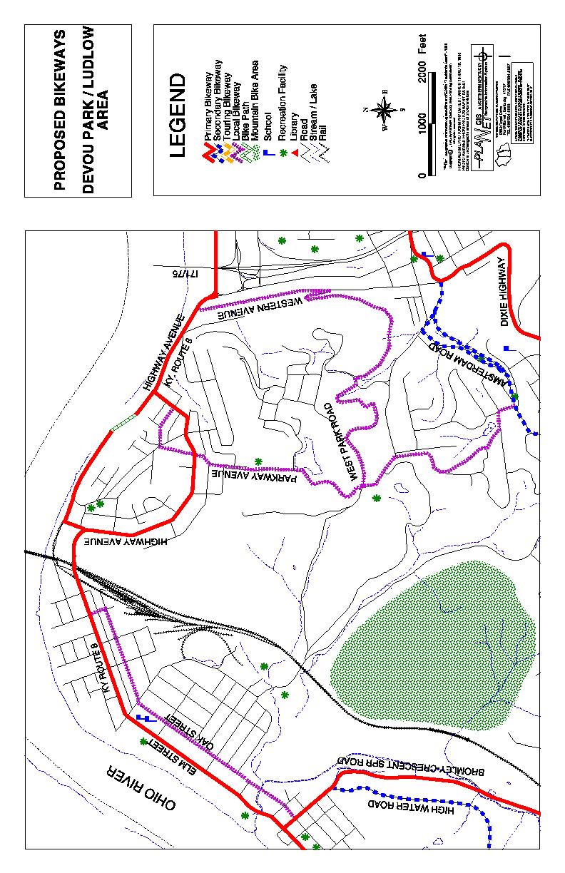
23 secondary bikeway. Other nearby Ohio River crossings are located in Newport, within one mile of the Fourth Street Bridge. Devou Park/Ludlow Area The Devou Park/Ludlow area identifies the westward extension of the Kentucky Route 8 bikeway through Ludlow and the western portion of Covington. This map also identifies local bikeways which provide access to Devou Park, the city of Park Hills and the city of Fort Wright. The plan identifies a bikeway/bike path along the Ohio River, which would provide shorter and easier east-west access between Covington and Ludlow, because it eliminates the hill on Kentucky Route 8/Highway Avenue. Fort Wright Area Bikeways on the Fort Wright Area map provide important connections from the Dixie Highway north-south route eastward via Kyles Lane/Highland Avenue (Kentucky Route 1072). Highland Avenue, which connects to the Madison Pike bikeway (Kentucky Route 17), is anticipated to be well utilized by cyclists traveling east. Westbound cyclists must contend with the uphill grade on Highland Avenue and therefore, may select an alternate route. Furthermore, Kyles Lane/Highland Avenue provides potential connection, via Howard Litzler Drive, to the Decoursey Pike bikeway, which is another north-south bikeway. In addition, Rivard Avenue, a local street, provides access from Dixie Highway eastward by passing under I-71/I-75, less than one-half mile south of the Dixie Highway/Kyles Lane intersection. From Rivard Drive a number of local streets are available for eastward travel, before a cyclist must return to either Kyles Lane or Highland Pike. Buttermilk Pike Area The Buttermilk Pike area may be one of the most critical areas identified within this plan. This area is an important crossroads along the Bromley/Crescent Springs/Erlanger north-south bikeway and includes a heavily congested commercial area, which provides a number of desirable destinations along with obstacles for cyclists traveling east-west through the area. The Buttermilk Pike area map identifies bikeways that provide access to the Crescent Springs commercial area, the Dixie Branch of the Post Office, numerous professional offices, schools and recreation facilities from the cities of Crescent Springs, Villa Hills, Crescent Park and Ft. Mitchell. Access across the I-71/I-75 is provided by Beechwood Road via an underpass. Commonwealth Avenue Area The Commonwealth Avenue area provides an east-west bikeway system that is KENTON COUNTY BICYCLE PLAN 3-8
24 nearly operational, because it utilizes several local streets that are currently suitable for cyclists. This bikeway extends from Turkeyfoot Road to the vicinity of I-71/I-75. This bikeway utilizes several parallel local streets to Commonwealth Avenue and Stevenson Road that currently have low traffic volumes and traffic speed limits. Parallel streets one block north (Erlanger Road) and one block south (Graves Avenue) provide a one-way pair which will minimize left-hand turn movements across traffic along Commonwealth Avenue for cyclists. These bikeways serve numerous school and recreation facilities, as well as provide reasonable access via local streets to commercial areas along Dixie Highway. Critical intersections along this bikeway are at Turkeyfoot Road, Dixie Highway and I-71/I-75. While the Turkeyfoot Road and Dixie Highway intersections can be negotiated (e.g., by walking) in the current condition, improvements would be required for the I-71/I-75 underpass. An important feature of this bikeway is that it connects to Houston Road, west of I-71/I- 75, which is part of the Boone County bikeway plan. Taylor Mill/Pioneer Park Area This area consists of proposed bikeways and bike paths that connect the Taylor Mill area with Pioneer Park area and with Doe Run Lake. The use of bike paths and lightly traveled roads make these bikeways particularly suited for basic and children cyclists. In this area two sections of bike path are proposed. One will connect Old Taylor Mill Road with Holds Branch Road (see following section on Holds Branch bike path) and the other will parallel Madison Pike prior to going under the road at Banklick Creek to access Pioneer Park. The bike path will continue using existing bike/pedestrian ways in Pioneer Park to Old Kentucky 17. BIKE PATHS Bike paths are separated from the roadway and are for the exclusive use by cyclists and other nonmotorized users such as wheelchair users, rollerbladers, runners and walkers. All proposed bike paths identified in this plan provide connections to other bikeways and, therefore, are links within the overall planned bicycle transportation system. The primary advantage of bike paths is that they accommodate all levels of cyclists (advanced, basic and children). Two proposed bike paths, one along the Licking River in Covington and the other along Holds Branch in Taylor Mill, have been previously identified in other studies including the OKI Regional Bicycle Plan. The Licking River proposed bike path was recommended in a 1987 study entitled, Licking River Study, prepared by the Landscape Architecture Program at the University of Kentucky. In 1978 the Taylor Mill Recreation Committee prepared A Proposed Taylor Mill Bicycle Transportation System study, which identified the Holds Branch bike path as a connection to Holds Branch Road. The study also identified several bikeways in the Taylor Mill area,such as along Old Taylor Mill Road, which are also identified in this Plan. KENTON COUNTY BICYCLE PLAN 3-9
25 The OKI Plan also identified the Green Line Bike Path, which followed the old Green Line route of the Cincinnati, Newport and Covington Railway Company. This route was used during the late 1800 s to mid 1900 s as a trolley line connecting Fort Mitchell, Fort Wright, Park Hills and Covington with Cincinnati and Newport. Several remnants of this route exist; however, most of the route has been reverted to private ownership, utility easements, or is now part of the public street system (e.g., Park Road in Fort Wright). In several other areas, commercial and residential structures have been built on land that once comprised the route. Because of the dissection of this route and the unlikely prospect that a bikeway of significant length, that would provide connections to other bikeways can be assembled, the Green Line is not mapped as part of this plan. Short sections of the route, however, would be beneficial to provide recreational bikeways and/or pedestrian walkways within neighborhoods for children cyclists and other neighborhood residents. MOUNTAIN BIKE (MTB) TRAILS/OFF-ROAD AREAS Three areas are identified for proposed use by mountain bikes: Doe Run Lake, Devou Park (west of Sleepy Hollow Road), and the Dry Creek valley area. These three areas, while having desired characteristics for mountain bike trails, currently do not promote the use of these areas for mountain bike riding. The use of mountain bikes on unpaved trails is often misunderstood in terms of trail damage and conflicts with other trail users. Mountain bikes actually cause minimal damage to trails as evidenced by the growing number of trails open for them in national, state and local parks and recreation areas. In Northern Kentucky, Tower Park in Fort Thomas and Middle Creek Park in Boone County are examples where trails for mountain bikes have been developed. The Northern Kentucky section of the Kentucky Mountain Bike Association (KyMBA) promotes responsible trail use and helps with trail maintenance at Tower Park. It is likely that volunteers from this organization would assist with trail construction and maintenance within the areas designated for mountain bike use in exchange for trail access. The areas identified for potential use by mountain bikes may also provide additional connections to other bikeways identified within this plan. Trails in the Doe Run Lake area provide the best example. These trails could connect the cities of Erlanger and Edgewood with the Taylor Mill/Pioneer Park bikeway system, thus providing an eastwest connection almost entirely across the county. KENTON COUNTY BICYCLE PLAN 3-10
26
27
28
29
30
31
32 BULLOCK PEN ROAD TAYLOR MILL ROAD I-275 PROPOSED BIKEWAYS TAYLOR MILL AND PIONEER PARK AREA r OLD TAYLOR MILL ROAD LEGEND FAIR OAKS LANE r r OLD MADISON PIKE MADISON PIKE HOLDS BRANCH ROAD Primary Bikeway Secondary Bikeway Touring Bikeway Local Bikeway Bike Path c r School Mountain Bike Area Recreation Facility $ Library Roads Streams / Lakes Rail N W E S Feet c c Geographic Information System.Winner of ESRI's "President's Award" Copyright C, 1995 by Northern Kentucky Area Planning Commission All rights reserved FROM AERIAL PHOTOGRAPHY DATED: MARCH 10 AND 15, 1985 PHOTO REVISED FROM PHOTOGRAPHY DATED: Contours unchanged in areas of photo revisions GIS A NORTHERN KENTUCKY Geographic Information System NORTHERN KENTUCKY AREA PLANNING COMMISSION 2332 Royal Drive Fort Mitchell, Kentucky TEL 606/ FAX 606/ NOTICE: THE NORTHERN KENTUCKY AREA PLANNING COMMISSION ACCEPTS NO LIABILITY ARISING FROM ANY INCORRECT, INCOMPLETE OR MISLEADING INFORMATION CONTAINED IN THIS PRODUCT. THE INFORMATION PRESENTED IN THIS PRODUCT IS ACCURATE FOR PLANNING PURPOSES ONLY
33 CHAPTER IV BIKEWAY IMPROVEMENTS The ultimate purpose behind the preparation of this plan is to implement roadway and other bicycle related improvements to facilitate and encourage increased use of bicycles for transportation in Kenton County. Sufficient improvements to increase safety for cyclists, while also minimizing inconvenience for motorists, should be incorporated for any bikeway designated within this Plan. Such improvements should be made to the maximum extent that is necessary and feasible to ensure that the roadway system is safer and more attractive for use by cyclists. These recommended improvements should be given a priority during the planning process, funding and implementation of roadway improvements. Furthermore, improvements that can be made rather easily, prior to actual roadway improvements (e.g., installation of bike route/share the road signs) should be made in order to begin implementation of this plan. Table 4-1 provides information regarding length in miles of each proposed bikeway by category. This table also provides a breakdown of miles of state roadway identified as bikeways. A majority of the identified bikeways are along state routes or U.S. routes, such as Dixie Highway, therefore, if improvements to these routes include bicycle transportation needs, most mileage in the Kenton County bikeway system will be addressed. TABLE 4-1 BIKEWAY LENGTHS (By Category) Category Length (Miles) State Route Mileage Dixie HWY Primary Secondary Touring Local 12.34* 0.91* None Paths 4.24* N/A N/A * Approximate length of mapped local bikeways SOURCE: Northern Kentucky Area Planning Commission, Planet/GIS Analysis. PREPARED BY:Northern Kentucky Area Planning Commission, The level of improvements made will depend on many factors associated with the KENTON COUNTY BICYCLE PLAN 4-1
34 existing characteristics of the roadway corridor and existing roadway conditions. For example, if land area is not available, either physically or fiscally based on project budgets or other available funding sources, the widening and/or restriping of the road for bike lanes or construction of parallel bike paths may not be feasible. Bike lanes and bike paths represent the highest level of bikeway improvements because they accommodate all three types of cyclists. While this plan has been prepared to improve and encourage bicycle usage, it is not intended that all designated bikeways will necessarily be improved to the highest level. Improvements should be made to the maximum extent that is necessary and feasible to ensure roadways are safer and more attractive for use by cyclists. Sufficient improvements must be made to facilitate safe and convenient bicycle trips by all types of cyclists to desired destinations, but it is likely not practical that all destinations be equally accessible. The questions, therefore, that must be addressed, on a case by case basis, are what type(s) of improvements will accommodate cyclists on each designated bikeway and what can be done on a short term or more immediate basis to begin implementing this plan. BIKEWAY IMPROVEMENTS Many types of bikeway improvements are available that can accommodate bicycle transportation. As previously mentioned, development of bike lanes and bike paths represent the highest levels of such improvements. At the other end of the scale is the installation of signage that merely designates roadways as bike routes and notifies motorists that they can expect cyclists to be sharing the road. The following list of typical bikeway improvements is generally presented from the lowest level (e.g., easiest/least expensive to implement, but primarily serves only advanced cyclists) or least costly of improvements to the highest level, which serve all types of cyclists, but are more costly and may be more difficult to implement, particularly along existing roadway corridors. Oftentimes these improvements may be used in various combinations along a roadway to create a bikeway. 1. Installation of signage identifying bikeways as bike routes; 2. Installation of bicycle safe storm drain grates and/or implementation of edge of pavement maintenance programs; 3. Creation of wider outside lanes (unmarked) by either restriping existing roadways to make interior lanes more narrow, thus, making inside lanes wider or adding pavement to outside lanes; 4. Use of paved shoulders. Paved shoulder, if wide enough, are an effective way to accommodate bicycle travel. Many newer roads are designed with paved shoulders and available to accommodate bicycles. When used as bikeways, paved shoulders should also be signed; 5. Construction of bike lanes. Bike lanes, which are separated from other traffic by stripping and signage, must be installed on both sides of a roadway along KENTON COUNTY BICYCLE PLAN 4-2
35 two-way streets, as bicycle must always travel in the same direction as traffic flow; 6. Construction of bike paths. Bike paths, unlike bike lanes, are located within their own rights-of-way or are wholly separated physically from motor vehicle travel lanes (see Chapter I) and can accommodate two-way traffic. Bike paths can also function as multi-use paths to accommodate pedestrians, wheelchairs, rollerbladers and others. The Kenton County Bicycle Plan Proposed Bikeway map identifies primary and secondary bikeways. When implementing roadway improvements along these routes, this plan advocates certain minimum bikeway improvements, as follows: 1. Installation of bike route and share the road signs; 2. Installation of bicycle safe storm drainage grates (e.g., that have slots perpendicular to the curb so that bicycle wheels do not get caught); and, 3. Continued maintenance of the edge of pavement, including removal or repositioning of rumble strips to allow adequate room for cyclists to remain as far right as possible within the roadway. These minimum improvements will accommodate all advanced cyclists and many basic cyclists. However, in order to best facilitate and encourage bicycle use, other improvements, as previously described, must be made. Additional information on specific issues regarding bikeway improvements will be provided in the following chapters. KENTON COUNTY BICYCLE PLAN 4-3
36 CHAPTER V ENHANCEMENTS Enhancements are recommended improvements, other than those that directly create bikeways, that complete the overall bikeway system making it more attractive for cyclists of all types to use. These improvements may cover a wide variety of items such as: facilities at the work place to shower and change clothes after commuting; and, bike parking facilities along public streets, at the work place, and at other destinations, such as retail centers, libraries and schools. In Chapter 2 of this Plan a number of goals and objectives were identified. The overall theme of the goals and objectives was to create an environment conducive to bicycle transportation. Existing and future transportation systems need to be enhanced to encourage bicycle transportation. This section will discuss those elements of a bicycle planning and engineering program that are essential to help realize these goals and, thus, to successfully integrate, bicycle travel into the existing and future transportation system. PLANNING AND ENGINEERING Planning, engineering and maintenance of bikeways and ancillary facilities to accommodate the bicycle as a vehicle are key elements necessary to enhance the existing transportation network for bicycling. These activities, conducted as part of the routine functions of government, will enable bicyclist to use the transportation system with relative safety and comfort. As a result, these activities encourage use by demonstrating that bicycling is recognized as having a place in the overall transportation network. INSTITUTIONALIZATION Institutionalization refers to the ongoing integration of bicycling considerations into the routine working of all levels of government agencies. Institutionalization is brought about via the support and recognition of engineering and planning for bicycle transportation by elected officials, agency heads and other public and private professionals who make policy decisions. 1 Institutionalizing bicycle planning and engineering in Kenton County is important for integrating bicycling as a mode of transportation. Three important steps toward institutionalization are: 1) designation of a bicycle coordinator; 2) formation of a citizens bicycle advisory committee; and, 3) public officials committed to improving the transportation system using multi-modal 1 US DOT, Federal Highway Administration, National Bicycling and Walking Study, August 1992 KENTON COUNTY BICYCLE PLAN 5-1
37 approaches. 2 Designating a staff person, at some level of local government, as the bicycle coordinator will provide an essential coordinating function. The role of the bicycle coordinator is to involve other departments of government (e.g. public works, recreation, schools, police departments, etc.) in the planning process. A bicycle coordinator would organize interdepartmental efforts or efforts between governments, and integrate bicycle planning objectives into other community activities. Public involvement in the bicycle planning process is necessary in order to fully institutionalize the process. This involves the establishment of a citizen-based bicycle coordinating committee, which can either be a new committee or this function may be carried out by an existing committee. The primary importance of such a committee lies in providing continuing public involvement, education and support. COORDINATION WITH OTHER PLANS AND PROGRAMS Planning and engineering of bicycle related improvements as part of other activities is important for effectively integrating bicycle transportation into the community. One measure of how well the planning and engineering of bicycle facilities is institutionalized into the broader planning for community development will be identified by the fact that the community considers bicycle transportation needs equally important to other infrastructure needs. For example, review of residential, commercial and industrial development should include bicycle components. To accomplish this effort, development regulations, zoning ordinances and subdivision regulations will need to be revised. This should include developing guidelines for: bicycle parking standards, signage requirements to identify bicycle routes, and bicycle safe storm sewer grates. Furthermore, regulations relating to design of bikeways must entail provisions for such items as: direct and convenient alignment to serve origins and destinations; continuity (e.g. connection between adjacent developments, which would also be conducive to pedestrian transportation); convenient location of bicycle parking at destinations; and adequate lighting and sight distances. 3 Roadway maintenance will be one of the most important aspects of coordination of the bicycle program with other programs. Roadway maintenance for bicycles differs from that of automobiles. Such maintenance will require an adequate commitment to bicycling as a transportation mode to help ensure that the system is safe for bicyclists. 2 Pinshof, Susan Anderson and Terri Musser, Bicycle Facility Planning, 1995, American Institute of Planning, PAS No Pinshof, Susan Anderson and Terri Musser, Bicycle Facility Planning, 1995, American Institute of Planning, PAS No. 459 KENTON COUNTY BICYCLE PLAN 5-2
38 DESIGN CONSIDERATIONS The AASHTO, Guide for the Development of Bicycle Facilities, provides significant detail on design of bikeways. The most affordable method of creating bikeways is by utilizing existing infrastructure. This entails improvements to increase safety of the shared roadway space. In addition to the design or redesign of roadway space, are considerations regarding the design of bike paths, which are separated from the roadway system. Bike paths may either be part of or adjacent to the right-of-way of existing roads, or utilize other available open space, such as abandoned railroads. It is anticipated that in Kenton County most of the proposed bikeway system, identified in Chapter 3, will utilize existing roadways. Many design considerations, such as minimum lane widths and signage are the same whether a bikeway facility entails new roadway construction or retrofitting an existing roadway. For example, the minimum widths for a bike lane is recommended to be four (4) feet in each direction regardless of whether a new roadway or existing roadway is involved. Oftentimes, the addition of a bike lane to an existing roadway is not feasible as sufficient right-of -way is not available and/or cost of utility relocation is not feasible unless the entire roadway is being reconstructed. The challenge, therefore, lies in how to retrofit an existing roadway to meet minimum standards that enhance safety and encourage use by bicyclists. Fortunately, there are many proven alternative treatments that can be used to make existing roadways suitable for use by bicyclists. Bike lanes specifically for use by bicycles is only one of the alternatives. Other alternatives include: re-stripping to create wider outside lanes, typically by decreasing the width slightly of interior lanes; installing bicycle safe storm sewer grates to enable the use of gutters, which may add up to two(2) feet of space to the outside lane; and, use of excess right-of-way to improve shoulders and/or widen the outside lane. Another method that can be used to provide bike lanes is to prohibit parking along roads during rush hour traffic and designating the curb lane for bicycle use only for limited morning and afternoon hours. In cases where re-stripping cannot be accomplished, sufficient right-of-way does not exist; or when funding is not currently available, signing of bike routes may be the only alternative available to improve safety. This plan recognizes that all roadways, except where bicycles are specifically prohibited, will be used by bicyclists. It is not the intent to install signage on all roadways, however, all designated bikeways should be signed. Signs can be a very effective first step to quickly designate bikeways and implement this Bicycle Plan. Signs help educate and inform other roadway users to expect its use by bicyclists and, therefore, add a measure of safety. However, along roadways which are heavily used by motor vehicles, signage will not encourage less experienced or skilled cyclists, such as the basic bicyclists and children to use the roadway. Advanced cyclists, accustomed to sharing the road with other vehicles and with more riding skill, will use any road where bicycles are permitted. Typically, basic KENTON COUNTY BICYCLE PLAN 5-3
39 and child cyclist require more improvements to the roadway before being encouraged to use them. Appendix A shows some commonly used traffic calming devises. Traffic calming entails slowing and/or redirecting the flow of vehicular traffic to provide more safe and pleasant conditions for pedestrians and cyclists. Traffic calming is an alternative for use on local streets. Speed bumps are typically not considered as appropriate traffic calming devices because they can adversely affect bicyclists. Design of new roadways or reconstruction of existing roadways, including arterials, collector and local streets must include bicycle considerations, if bicycling is to be promoted as a viable alternate mode of transportation in Kenton County. One purpose of this Bicycle Plan is to designate roads that should receive high priority for bicycle improvements (e.g. primary routes, See Chapter 3). However, as previously noted, improvements to all roads where bicycles are not prohibited should also include considerations for bicycle safety. Appendix B includes graphic details on a variety of design alternatives in addition to the previously described methods to enhance roadways for bicycle transportation. Design Problems: Several design problems or practices exist that cause particular problems for bicyclists. Many design practices are done because they are considered good practices for roadway design and, in fact, are good design. However, these practices, which may be good for motor vehicles, often create problems for bicyclists. Other problems exist, which may be more long standing and not a result of recent roadway improvements but rather are preexisting conditions that tend to cause more problems for bicyclist than for motor vehicles. Following is a list and brief discussion of some of these problems: Rumble Strips - These are devices, created during roadway paving, designed to warn motorists to move back into the right driving lane when they stray onto the shoulder. This warning is accomplished by creating a slight vibration/noise when the tires of vehicles cross these strips. Vibrations caused by rumble strips are potentially hazardous to bicyclists, who ride on the right side of the right lane and may move to the shoulder or to the extreme right of the drive lane when other vehicles pass. These vibrations can create control problems and/or may cause cyclists to quickly overcompensate and swerve back into traffic. On roadways with wide (5 to 10 foot) paved shoulders rumble strips are less problematic because adequate room exists to ride on the shoulder to the right of the strips. On narrow shoulders of less than five (5) feet in width, rumble strips also eliminate space that otherwise could be used by cyclists to provide additional spacing between other vehicles. Rumble strips should be eliminated except along roadways where paved shoulders exist that are at least eight (8) feet in width allowing bicycle travel on the shoulder. KENTON COUNTY BICYCLE PLAN 5-4
40 Furthermore, in situations where rumble strips are used along roadways with paved shoulders, either of the following location criteria should be used: 1. Rumble strips should be located immediately adjacent to the white line, sometimes referred to as the fog line; or, 2. Rumble strips should be located approximately two (2) to four (4) feet right of the right line allowing sufficient space for bicyclists to ride between the white line and the strips. One of the key overriding issues is that shoulders collect debris, which is hazardous to bicyclists. However, due to the slope used to allow water runoff, the first three (3) to four (4) feet typically remains relatively free of debris because of wind and rain that move it toward the right edge. This usually allows adequate space to be used that is relatively safe for bicyclists if the previously mentioned criteria are followed. The alternative to this is to assure that adequate maintenance measures are in place to periodically remove debris, thus, making the entire shoulder safe for cycling. In any event it is important to provide adequate space for cyclists to avoid rumble strips when they are included as part of roadway design. Railroad Crossings - Railroad crossings cause problems primarily due to the roughness of crossing them on a bicycle. These can be improved and or maintained to be easily crossed. However, regardless of roughness, when railroad crossings are not at a right angle to the roadway, problems are caused for the cyclist which do not exist for other vehicles. Safe negotiation of railroad crossings by cyclists entails crossing with the bike wheels at a right angle to the railroad tracks. In situations where tracks are not at a right angles, or nearly so across a roadway, bicyclists must use more of the roadway or lane, other than the right side, to safely cross the tracks. Appendix A includes a diagram that shows how additional paving along the right edge of pavement will allow cyclists to remain on the right side of the lane. This will allow bicyclists and other vehicles to cross the railroad tracks and remain on the right side of the lane together. Narrow Bridges and Underpasses - Narrow bridges and underpasses are typical along older roadways. These situations potentially cause problems when motor vehicles and bicycles approach them simultaneously. It is important, particularly along designated bikeways, to install adequate signage directing motor vehicles to yield to bicyclists. Oftentimes narrow underpasses are dark and/or have pavement problems and debris which must be avoided by bicyclists. Operators of other vehicles must be aware that bicyclists may be sharing such space and a need to adjust speed to help assure safe passage KENTON COUNTY BICYCLE PLAN 5-5
41 of both vehicles. Traffic Control Devices - Traffic control devices, such as inductive loops and push-button traffic signal control devices, which are designed to activate traffic signals for motor vehicles and pedestrians, often are not effective for cyclists. Inductive loops, which are embedded within the roadway and create an electrical current that activates the traffic signal, typically do not respond to bicycles and/or are not located properly to allow bicycles to activate then from the right side of the lane. Push-button devices are generally located for easy access by pedestrians from the sidewalk. Cyclists, stopped along the curb cannot easily reach these buttons without dismounting. Therefore, one solution is to install push-buttons so that cyclists can reach them from the right of the adjacent lane, without the need to dismount. If possible, inductive loops, of a type which are sensitive to bicycles could also be installed and located in a manner that cyclists on the right of the lane will activate the signal. Another safety measure, used in Vancouver, British Columbia, are flashing green lights activated when push buttons are used, that serve to warn motorists that bicyclists and/or a pedestrians are in the intersection. Motorists turning right or left will then be aware to yield the right of way, thus, providing for a more safe environment for pedestrians and cyclists. Speed bumps, a commonly used traffic control device, are potentially hazardous to bicyclists due to the difficulty of crossing them except at very low speed. Even at a low speed the potential to fall is significant for all but advanced cyclists. Speed bumps can be designed so as to allow gaps along the right side of the bumps for bicyclists to pass and avoid the bump. It is recommended that when speed bumps are installed that gaps along both sides of the roadway be used. These gaps should be at least four (4) feet wide, including space along gutters if bicycle safe grates are used when storm sewer drains are located in the vicinity of the speed bumps. Storm Sewer Grates - Storm sewer grates, as previously mentioned, can cause problems for bicyclists. Holes or slats in these grates are very hazardous if they allow bicycle wheels to fall into the grates (See Appendix A ). Most newer grates are designed to be bicycle safe. When storm grates are not safe for cyclists, they essentially remove up to two (2) feet of curb/gutter that can be used by bicyclists. Bicycle safe grates, therefore, effectively widen outside lanes providing greater separation between bicycles and other vehicles sharing the right lane. Bridge Expansion Joints - Expansion joints, which are integral to the design and function of bridges can cause problems to cyclists. Some joint designs KENTON COUNTY BICYCLE PLAN 5-6
42 have holes/slats, similar to storm sewer grates, which are hazardous to the bicyclist. Other designs create bumps, which may only be an inconvenient bump for motorists, can cause significant problems for a bicyclist. Safe negotiation of such expansion joints by the bicyclist requires a significant reduction in speed to cross without falling. Whenever possible expansion joint designs should be smooth and without holes/slats. Pavement Joints - Pavement joints are the joints which run parallel to the curb/gutter and the roadway. When such joint are uneven or a gap exists they cause potential safety problems and eliminate the gutter area for use by bicyclists. As previously noted the gutter area provides additional space for bicycle travel and is useful to further separate bicycles from other vehicles using the roadway. Bicycle wheels can get trapped in spaces between the joints and/or the bump caused by uneven joints can cause difficulty with bike handling and result in mishaps. Such joints should be smooth and as a maintenance item inspected periodically and repaired as necessary. Maintenance: Maintenance issues regarding roadways and bicycle use are similar to design problems described previously. Many roadway conditions or the extent/severity of such conditions that occur through usage, may not be problematic for most vehicles, but cause problems for bicyclists. Problems that might be put off for later repair may be acceptable if only motor vehicles are considered. When bicycles are considered damage should be repaired sooner so as to not impair safety. Therefore, maintaining roadways for safe use by bicycles will likely involve procedural changes in city, county and state maintenance programs. Damaged roads, particularly damage within the right lane and/or along the edge of pavement may require more immediate attention to maintain for bicycles. For example, if bicyclists must move further toward the center of the right lane to avoid broken pavement, the potential for conflicts with other vehicles increases. Additional information regarding maintenance is presented in Chapter 6, identifying existing conditions along designated bikeways in Kenton County. ENCOURAGEMENTS Certain physical improvements, other than those directly relating to roadways, as previously discussed, are important to encourage bicycle use. These improvements, which tend to complete the overall transportation system for bicycling, also create convenience and comfort, therefore, enticing more bicycle use. Following are brief discussions of additional physical features that will encourage increased bicycle use. Bicycle Racks and Lockers Conveniently located bike racks and lockers are likely the most important non- KENTON COUNTY BICYCLE PLAN 5-7
43 roadway improvements that will encourage increased bicycle use. Many non-work trips are short in length and very suitable for bicycle use, even for beginning cyclists. The lack of a safe and accessible parking space for the bike, once the destination is reached, only further deters bicycle use. Many destinations within Kenton County can currently be reached along relatively light traveled local streets, however, once the bicyclist has arrived, the only parking available is often sign posts, newspaper racks, soft drink machines or handrails. Bikes locked to these types of facilities oftentimes block sidewalks and impede pedestrian travel. These types of unnecessary conflicts between bicycles and other users are avoidable with well placed bicycle parking facilities. Bicycle parking facilities are manufactured and classified in three categories. Table 5-1 presents information, including estimated costs, on each class. Lockers (Class 1) are most desirable at location where bikes will be stored for longer periods of time and in all weather conditions. They secure the bicycle along with other equipment (helmets, tools, etc.) and provide protection from inclement weather. Class 2 and 3 bicycle racks, are for more general purpose locations. The most common racks used are Class 3, which are relatively low in cost and durable; provide basic security; easily located because they occupy smaller spaces than either Class 1 or Class 2; and, they require less maintenance. Bicycle Parking One key element of institutionalizing bicycle planning is to update off-street parking requirements to include bicycle parking. 4 Table 5-2 provides a general guide to parking standards for bicycles. This plan recommends that the recommended model zoning ordinance serving as a guide for use in Kenton County be revised to include bicycle parking standards. The recommended minimum standards listed in Table 5-2, may seem excessive given the perceived level of bicycle usage. However, as has been discussed previously, parking facilities and other transportation improvements for bicycles encourage increased bicycle usage. It is, therefore, important to provide facilities prior to demonstrated use. 4 Laidlaw, Danelle and Daphne Hope, Community Cycling Manual - A Planning and Design Guide, Update Draft - March 1999, Canadian Institute of Planners KENTON COUNTY BICYCLE PLAN 5-8
44 TABLE 5-1 BICYCLE PARKING INFORMATION MODEL STORAGE CAPACITY ADVANTAGES DISADVANTAGES COST RANGE CLASS 1 LOCKERS 1-2 BICYCLES HIGH SECURITY STORAGE. IDEAL FOR LONG-TERM STORAGE EXPENSIVE $500-$1,300 CLASS 2 CLASS 3 SECURES BOTH WHEELS AND FRAME SECURES ONE WHEEL AND FRAME MEDIUM SECURITY. PER BIKE GREAT WHEN MOVING PARTS, $65-$150 COUPLED WITH COVERED PROTECTION FROM THE ELEMENTS COMPLEX DESIGN, MAY NOT WORK WITH ALL U- LOCKS SIMPLE DESIGN, AFFORDABLE, CAN BE MANUFACTURED BY A OFFERS LOW-SECURITY LOCAL WELDER. FOR LONG-TERM SUPPORTS FRONT AS PARKING WELL AS WHEEL PER BIKE $65-$80 SOURCE: Bicycle Facility Planning: A Resource for Local Governments Bike Parking, Pro Bike News April 1996 Pictures: Bureau of Transportation Statistics ( PREPARED BY: Northern Kentucky Area Planning Commission 1999 KENTON COUNTY BICYCLE PLAN 5-9
45 TABLE 5-2 BICYCLE PARKING - SUGGESTED MINIMUM SPACE REQUIREMENTS TYPE OF ESTABLISHMENT PRIMARY OR SECONDARY SCHOOL COLLEGE OR UNIVERSITY CLASSROOMS SHOPPING MALL COMMERCIAL STREET SPORT OR RECREATION CENTER OFFICE BUILDING GOVERNMENT BUILDING MOVIE THEATER OR RESTAURANT MANUFACTURING PLANT MULTI-UNIT HOUSING PUBLIC TRANSIT STATION MINIMUM NUMBER OF BICYCLE PARKING SPACES* 10% OF NUMBER OF STUDENTS, PLUS 3% OF NUMBER OF EMPLOYEES 6% OF NUMBER OF STUDENTS, PLUS 3% OF NUMBER OF EMPLOYEES 5% OF NUMBER OF AUTOMOBILE SPACES 1 SPACE PER 3,000 SQ. FT OF RETAIL SPACE 12% OF NUMBER OF AUTOMOBILE SPACES 10% OF NUMBER OF AUTOMOBILE SPACES 10% OF NUMBER OF AUTOMOBILE SPACES 5-10% OF NUMBER OF AUTOMOBILE SPACES 4% OF NUMBER OF AUTOMOBILE SPACES 1 SPACE PER 2 APARTMENTS/CONDOS OTHER LAND USES 20 SPACES MINIMUM * A minimum of two (2) spaces is required for all uses. After the first fifty (50) spaces are provided, requirements shall be reduced by half % OF NUMBER OF AUTOMOBILE SPACES SOURCE: Pinshof, Susan Anderson and Terri Musser, Bicycle Facility Planning, 1995, American Institute of Planning, PAS No. 459 PREPARED BY: Northern Kentucky Area Planning Commission, June 1999 KENTON COUNTY BICYCLE PLAN 5-10
46 Bicycle Bus Racks In Chapter I, the physical terrain was discussed as a potential deterrent to bicycling in Kenton County. Bicycle racks on every TANK (Transit Authority of Northern Kentucky) bus may be one of the most important element of this plan that will help increase bicycle usage and successfully integrate bicycling into the transportation system, by providing convenient passage from the Ohio River valley to the plateau areas. As mentioned in Chapter 1, utilitarian trips by bicycle, generally will not exceed five (5) miles on average. Difficulty with terrain will likely reduce this average along with the total number of trips made by bicycle. 5 In addition, to helping cyclists handle difficult terrain, bike racks on buses provide several other benefits that substantially improve the transportation system for bicyclists and that can extend trip length significantly. Bus racks also allow greater flexibility for the transit user, who will have alternate transportation available to and from the bus stop on both ends of the trip. Bike racks along with bike lockers encourage transit riders who live within bicycling range of a park and ride location to ride a bike to the bus stop versus driving an automobile. Overall bike racks on buses can be expected to increase multi-modal trips (e.g. bike and bus or bike, bus and walk), which together will further decrease automobile usage. Bike racks on buses are easy to use and cause minimal delays when boarding or disembarking from the bus. A single bus rack can carry two (2) bikes and is generally installed on the front of the bus where the bus driver can easily see when bikes are loaded and unloaded prior to proceeding along the route. Approximate costs for bus racks range from $ to $ Shower and Locker Facilities Shower and locker facilities at places of employment, along with bicycle parking, are important end of trip facilities that serve to increase the comfort and convenience of cyclist and, thus, encourage bicycle use. Many potential bicyclists will be employed in jobs that require a change of clothing after the trip to work and for the trip home. Shower and locker facilities, which make clean-up and clothing storage convenient, ease this transition from cycling to working. EDUCATION Education of the public, both bicyclists and motorists, is a very important element of a bicycle program. In previous sections, this plan presents information on engineering 5 Laidlaw, Danelle and Daphne Hope, Community Cycling Manual - A Planning and Design Guide, Update Draft - March 1999, Canadian Institute of Planners 6 Robinson, Lisa, Sportworks, Woodinville, Washington, Interview with NKAPC staff, May 1999 KENTON COUNTY BICYCLE PLAN 5-11
47 and roadway improvement needs that will encourage cyclists to use the transportation system and will help make the system truly multi-modal. Education programs are important to help train citizens on the proper legal use of transportation facilities. Furthermore, it is likely that many basic, children cyclists and non-cyclists are hesitant to ride, particularly in traffic due to lack of basic cycling skills. Education programs should include the following elements: 7 Information that clearly emphasizes to motor vehicle drivers and cyclists that roadways are to be shared and the proper methods that should be followed by both to ensure equal accommodation; Teach the cyclists the rules of the road; particularly child cyclists and other young cyclist who have not yet received driver training; Teach responsibilities of road use; and, Teach bicycle handling skills. Education programs are not provided on a consistent basis at the local level. Most programs, when they are provided, are generally conducted for young children and focus on very basic skills of bicycle handling. Oftentimes, these programs are conducted by police and/or fire departments, service clubs and organizations, or Scouting programs. On the national level, the League of American Bicyclists (LAB) offers the "Effective Cycling" Program, which is a multi-course program teaching skills to all levels of cyclists that improves skills and competency to handle every cycling situation. Local bicycle clubs, who are members of LAB, are encouraged to have some of their members become Certified Instructors of the Effective Cycling Program so that this program can be taught at the local level. In Kentucky, the University of Kentucky Cooperative Extension Service is preparing a program, modeled after the LAB Effective Cycling Program. The Extension Service Program - called B.I.K.E. (Bicycling In Kentucky Education Program) will provide safety and skill development in the state through law enforcement personnel and community leaders such as: citizen groups, teachers, Extension volunteers and personnel. ENFORCEMENT Proper enforcement of vehicular laws relating to both bicyclists and motorists brings together the goals of engineering design, encouragement and education by helping to ensure proper and safe use of facilities. Many cyclists ignore vehicular laws, thus, placing themselves and others in potential danger. By ignoring these laws, bicyclists do not enhance their own image as courteous and safe highway users. Likewise, many motorists do not understand their responsibilities in regards to sharing the road with bicyclists. Enforcement agencies tend to allow cyclists to break the laws of vehicular use and, thus, may be condoning irresponsible bicycle riding. The Kentucky Drivers Manual, clearly delineates the rights and responsibilities of both motorists and bicyclists 7 Laidlaw, Danelle and Daphne Hope, Community Cycling Manual - A Planning and Design Guide, Update Draft - March 1999, Canadian Institute of Planners KENTON COUNTY BICYCLE PLAN 5-12
48 with bicyclists. Enforcement agencies tend to allow cyclists to break the laws of vehicular use and, thus, may be condoning irresponsible bicycle riding. The Kentucky Drivers Manual, clearly delineates the rights and responsibilities of both motorists and bicyclists and their respective relations in sharing roadways. The objective of enforcement of laws in regards to bicycling should be as follows: 8 Reduce the number of accidents and level of injuries sustained; Increase compliance with the "Rules of the Road"; Reduce bicycle theft; and, Develop public relation programs to encourage all of the above. 8 Laidlaw, Danelle and Daphne Hope, Community Cycling Manual - A Planning and Design Guide, Update Draft - March 1999, Canadian Institute of Planners KENTON COUNTY BICYCLE PLAN 5-13
49 CHAPTER VI ROUTE SURVEYS AND ANALYSIS Chapter 3 identified the system of bikeways for Kenton County. This chapter identifies existing physical conditions of most of the recommended bikeways in order to provide basic knowledge of problems that need to be addressed. Chapter 5 presented information on methods and/or programs necessary to fully implement a bikeway system that encourages the use of bicycles for utilitarian and recreation purposed. The physical issues identified in this chapter present one of the primary problems, identified in Chapter 5, that must be addressed - the scope of physical improvements necessary to bring our existing roadways to a safe standard for use by bicyclists. In Chapter 5, it was also noted that the most cost effective method of creating bikeways is by utilizing existing infrastructure. Information contained in this Chapter and on accompanying maps will help provide basic information necessary for decisionmaking in regards to roadway improvements for bicycle transportation. EXISTING CONDITIONS Roadway Characteristics for Bikeways Map 6-1, identifies existing conditions by categorizing each identified recommended bikeway into one of four categories based on the number of deficiencies identified along each bikeway and the anticipated ease of addressing such deficiencies. Information for this map was obtained through surveys of each bikeway, conducted by NKAPC staff. The survey identified the following items: Edge of pavement repair needed - 1 to 2 feet from edge Edge of pavement repair needed - over 2 feet from edge On-street parking Unsafe storm sewer grates Debris in Roadway (e.g. gravel from driveway) Shoulder - paved and suitable for bicycles Shoulder - unpaved and/or unsuitable for bicycles (e.g. too narrow, etc.) Railroad crossings Traffic volume/vehicle type (e.g. large trucks) 1 Rumble strips Steep Grades 1 Traffic volume was evaluated using numbers of vehicles and information from on-site surveys, etc. to determine those areas where traffic was consistent and where cyclists would always be riding with other vehicular traffic during peak traffic situations for the road, as well as, off peak. Areas indicated on Map 6-1. are significant in that additional care will be needed to enhance these areas for all but Advanced Cyclists. KENTON COUNTY BICYCLE PLAN 6-1
50 Based on the survey each recommended bikeway or segment of a bikeway was categorized into one of the following categories: Good Slight Moderate Severe No conditions exist that impede the use of the roadway for bicyclists. Route identification and "Share the Road" type signage would be desirable. Conditions exist which appear to be capable of being resolved through routine maintenance. (e.g. pothole and/or other minor pavement repairs, debris cleanup, replacement of storm sewer grates, etc.) Conditions exist which appear to require a significant outlay of funds for repair or maintenance, or which may not be feasible for repair for bicycle use only (e.g. shoulder repair/widening, removal of on-street parking, etc.) Conditions exist, that would require major funding and would likely require major improvements for other vehicular transportation (e.g. repair/improvements to railroad crossings, widening of narrow bridges/underpasses, major pavement replacement, poor sight distance, etc.). Symbols are used on Map 6-1 to identify areas or locations of narrow bridges/underpasses, high traffic volume, railroad crossings, and steep grades. Many local streets, which are identified as part of the recommended Kenton County bikeway system are not included within this survey. Most of these streets have very low traffic volume and, thus, it is much easier for bicyclist to steer clear of roadway hazards. It appears, also, that most problems along these roads are minor in nature and should be easily handled through routine maintenance. Roads identified in Chapter 3 (see Proposed Bikeway Map) as touring bikeways, in the south part of Kenton County have also not been included due to lower traffic volume and anticipated low volume of use by bicyclists. Table 6-1 shows the results of the survey conducted of the bikeways identifying the approximate mileage of each condition category shown on Map 6-1. KENTON COUNTY BICYCLE PLAN 6-2
51 TABLE 6-1 CONDITION CATEGORY Good Slight Moderate Severe APPROXIMATE MILEAGE Based on this survey a majority of proposed bikeway mileage is along roads that rank either as good or with slight problems. It is anticipated that problems along routes ranked as slight can be addressed with routine maintenance. The approximate eighteen (18) miles of severe conditions occur along portions of six (6) proposed bikeways. Two of these, Turkeyfoot Road (Ky. State Route 1303) and Madison Pike (Ky. State Route 17) are being addressed with highway improvement projects, both of which include bicycle improvements. State Maintained Route Information To accompany Map 6-1, three other maps have been included in Phase II of this Plan, which should be useful in preliminary planning for bicycle improvements. These maps are: Map 6-2 Map 6-3 Map 6-4 Right of Way Widths Along State Routes Pavement Widths for State Routes Available Right of Way Beyond Pavement Width for State Routes Information for these maps was obtained from the Kentucky Transportation Cabinet's Highway Information System. This system only provides information for state maintained roads, however, most bikeways identified in Kenton County are state maintained roads. As discussed in Chapter 5, it is anticipated that most bikeways within Kenton County will be developed by utilizing existing roadways because of its affordability over bikepaths that are separated from the roadway. Information provided on these maps, which is provided based on an average of measurements between mileposts, will help with preliminary planning, selection of potential alternative treatments to accommodate bicycling, and determination of KENTON COUNTY BICYCLE PLAN 6-3
52 feasibility. For example, pavement width information may indicate that restripping may be a feasible treatment to provide a wider right-hand lane for cyclist. Information regarding availability of extra rights-of-way will indicate the potential for lane widening and/or pavement of wider shoulders. In all cases, however, more detailed on-site surveys will be needed to complete the planning process. LONG AND SHORT TERM IMPROVEMENTS Long term improvements are those which will involve significant expenditure of funds and which need to be incorporated within the scope of other highway improvements. Short term improvements are those that can be completed rather simply and with minimal expenditure of funds. For example, roadway maintenance which is currently funded on both local and state maintained roads, if done with knowledge of bicycling needs and safety concerns, should not entail significant expenditure of additional funds. Other short term improvements such as signage are very important for establishing roadways as bikeways regardless of whether major reconstruction may be needed to ultimately make the bikeway usable for every type of cyclist. Signage along those roadways identified as bikeways in this plan will accomplish two purposes, as follows: 1. Should encourage bicyclist to use these routes versus others that have not been identified, thus, leaving them for primary use by motorists; and, 2. Identify the route as a bikeway, thus notifying both bicyclists and motorist that these roads are "official" bikeways. This should result in additional safety for bicyclists as motorists become informed to be aware that the roadway is being shared. The primary short term improvements that can be accomplished are: (1) signage of all bikeways; (2) maintenance of all roads designated as bikeways, in a manner consistent with the needs of bicycles; and, (3) creation of/implementation of education and enforcement programs as previously described. This plan identifies: (1) roadways or corridors which are desirable for bicycles; (2) the level of problems associated with each route in terms of their use by bicyclists; and, (3) provides basic information necessary to implement an effective bicycle transportation program within Kenton County. This plan does not recommend specific long term improvements for each route. The development of a bikeway system may involve a range of improvements, short and long term, which will occur over time and the most extensive are likely to only occur along with major improvements/reconstruction of roadways for all purposes - not just for bicycles. For example, three major roadway improvements projects currently being planned in Kenton County by the Kentucky Transportation Cabinet (KyTC) - (Turkeyfoot Road,Ky. KENTON COUNTY BICYCLE PLAN 6-4
53 State Route 1303; Madison Pike,Ky. State Route 17; and, Taylor Mill Road,Ky. State Route 16) are considering improvements for bicycles as an element of design for these routes. Each of these routes is designated as a bikeway in this plan. Improvements being planned for each of these roadways are extensive in nature. Engineers planning and designing these improvements have a variety of methods, each acceptable under the AASHTO Guide for the Development of Bicycle Facilities, to use to accommodate bicycle transportation (e.g. paved shoulder bikeways, bike lanes, wider outside lanes). Therefore, for this plan to specify the type improvements desired would be premature until such time as roadway improvements are being made and corridor selection and design alternative are being planned. Table 6-2, presents average costs nationally for a variety of bikeway improvements. These costs are from the Federal Highway Administration, National Bicycling and Walking Study (1992) and are presented to give a general idea about costs of roadway improvements for bicycling. While general in nature, the data within Table 6-2, provides information regarding potential additional costs associated with improving roadways for bicycle transportation. The table also includes information regarding costs for construction of bikepaths. KENTON COUNTY BICYCLE PLAN 6-5
54 TABLE 6-2 TYPE OF IMPROVEMENT Multi-Use Trail (Unpaved) 12 foot - Soil 12 foot - Aggregate Multi-Use Trail (Paved) 12 foot - Concrete 12 foot - Asphalt Urban Bike Lanes 4 foot wide, both sides Rural Bike Lanes 4 foot wide, both sides Paved Shoulders 4 foot wide, both sides ESTIMATED COSTS (Per Mile) $80,000 $100,000 $500,000 $200,000 $200,000 $110,000 $110,000 Wide Curb Lane 14 foot wide, both sides $130,000 SOURCE: Federal Highway Administration, National Bicycling and Walking Study, 1992 PREPARED BY: Northern Kentucky Area Planning Commission, 1999 KENTON COUNTY BICYCLE PLAN 6-6
55 CHAPTER VII RECOMMENDATIONS FOR IMPLEMENTATION Throughout this Plan many measures have been described that are necessary to develop a bikeway system in Kenton County that will result in an increase in bicycle transportation. While all measures discussed are necessary, recommendations in this Chapter only represent those that are most important to begin developing a bikeway system. The following is a list of the key recommendations in the development of a bikeway system for Kenton County. 1. Institutionalizing bicycle planning into the routine working of government within Kenton County is likely the single most important implementation measure necessary to meet the goals of this Plan. As noted in Chapter 5, three steps are involved in institutionalizing bicycle planning: 1) designation of a bicycle coordinator; 2) formation of a citizens advisory committee; and 3) public officials committed to improving the transportation system using multi-modal approaches. This plan recommends initiation of the first two steps, which will then work to develop the final step of educating local officials, both elected and appointed, to include planning for bicycle transportation in the everyday work of government agencies. It is further recommended that the Northern Kentucky Area Planning Council, comprised of representatives of each local legislative body in Kenton County, in coordination with the Northern Kentucky Area Planning Commission be utilized to both appoint a bicycle coordinator and publicize the appointment to their respective jurisdictions. Initially, the coordinator could be a current employee of the Northern Kentucky Area Planning Commission, with the understanding that eventually it could evolve into a full-time position within the government structure. The Area Planning Council should also establish a citizens advisory committee, from a list provided by the Northern Kentucky Area Planning Commission. This committee should be comprised of citizens interested in bicycling and local officials (e.g city engineers, public works directors, etc.) responsible for maintenance of roadways. Attempts should be made to represent as many local jurisdictions as is feasible on this committee. 2. The most important physical improvement to create a bikeway system, with the exception of bikeway construction, is the installation of signage. Signage is important for designating bikeways and establishing roadways as routes for bicycle travel. Signs will begin notifying other roadway users to expect cyclists along those routes, thus, improving safety. Compared to the costs of other physical improvements and the time necessary to implement them, signs are inexpensive and can be quickly installed. KENTON COUNTY BICYCLE PLAN 7-1
56 Signage is needed immediately to begin the process of developing a bikeway system. Two signs are most commonly used and considered as standard throughout the county. These are "Bike Route" and "Share the Road" signs. Bicycle route signs are information signs designed to guide cyclists to destinations. Share the road signs are directive signs reminding motorists, bicyclists and other road users to be conscientious of one another. Both signs are permitted per the U.S Federal Highway Administration's (FHWA), Manual on Uniform Traffic Control Devices (MUTCD), which is used by the Kentucky Transportation Cabinet (KyTC) via directive of state statute. This plan recommends the use of "Share the Road" signs. "Share the Road" signs, which are yellow diamond shaped signs with an icon depicting the road being shared by motor vehicles and bicycles or other slow moving vehicles (e.g. tractors, buggies, etc.), are more visible and more accurately portray the message of dual usage of the roadway system by motor vehicles and bicycles than the "Bike Route" signs. Research conducted by the FHWA based on the "Share the Road" sign, indicates that the sign's meaning comprehension rate was ninety-two (92) percent and its action comprehension rate was 100 percent. 1 Bicycle signage portraying the same message should attain similar levels of understanding and, therefore, enhance safety for bicyclists. Other signage, in addition to "Share the Road" signs may be desirable in the future to name and/or number specific routes for mapping or other informational purposes. In addition, to installation of "Share the Road" signs, it may be desirable to name and/or number bikeways identified in this Plan. By specifically identifying by name and/or number, it is possible to further publicize and promote the bikeway system via maps and attractive signs. Approval from the KyTC must be obtained for installation of all signs along state maintained roadways. 3. Maintenance of proposed bikeways are part of the efforts related to institutionalizing bikeway development, previously described, that may take time to incorporate into everyday working of government. Many maintenance issues can be addressed easily as part of routine roadway maintenance. Emphasis should be placed on those roadways identified as proposed bikeways and those problems described herein (see Chapter 5 and Appendix C) should be located and programmed for repair. 4. Provisions for bicycle parking are also an important element in institutionalizing bicycle transportation. Bicycle parking facilities at the bicyclists destination is 1 Federal Register, Vol. 62, No. 6, Thursday, January 9, 1997 KENTON COUNTY BICYCLE PLAN 7-2
57 important to encourage further use of bicycles regardless of other improvements made to the transportation system. Lack of safe and well located bike parking facilities is a deterrent to increased use which can be reasonably implemented. This Plan recommends further review and amendments to the parking regulations within the zoning ordinances of all local jurisdictions, where appropriate, to include minimum requirements for bicycle parking facilities at all commercial, office, and industrial work places and at public gathering areas. Table 5-2 identifies suggested minimum bicycle parking regulations. Subdivision regulations should also be reviewed and amended, where appropriate, to require signage on all new collector streets. These streets will eventually become new additions to the bikeway system and connect residential areas with other destinations. Incorporating new streets into the bikeway system would help to insure that all residents have access by bicycle to other destinations as they do by other vehicular modes. Streets developed as private streets should also include signage and be incorporated into the bikeway system. Additionally, subdivision standards should be reviewed and revised to require bicycle safe storm sewer grates on all public or private streets. CONCLUSION Implementation of this plan will involve coordination of many activities of the various governments (city, county, state and federal) with jurisdiction in Kenton County. While recommended actions in this plan may take many years to complete, it is important to note that simple steps toward implementation as described in the Chapter can show progress in a short period of time. Finally, when considering the value of implementing this plan and creating an environment more conducive to bicycle transportation - remember this about transportation in the United States - two bicycle mechanics, who owned a bike shop in Dayton, Ohio were the first to fly and the first automobiles were chain driven, a design based on the bicycle. KENTON COUNTY BICYCLE PLAN 7-3


58 APPENDIX A FIGURE A-1 TYPICAL RAILROAD CROSSING DETAIL FIGURE A-2 BICYCLE SAFE SEWER GRATES KENTON COUNTY BICYCLE PLAN APPENDIX A
59 FIGURE A-3 TRAFFIC CALMING TECHNIQUES/DEVICES KENTON COUNTY BICYCLE PLAN APPENDIX A
60 APPENDIX B FIGURE B-1 TYPICAL BIKEPATH SECTION KENTON COUNTY BICYCLE PLAN APPENDIX B
61 FIGURE B-2 BIKEWAYS ON FIVE-LANE THOROUGHFARES KENTON COUNTY BICYCLE PLAN APPENDIX B
62 FIGURE B3 BIKEWAYS ON STANDARD FOUR-LANE STREETS KENTON COUNTY BICYCLE PLAN APPENDIX B
63 FIGURE B-4 BIKEWAYS ON RESIDENTIAL AND COMMERCIAL COLLECTOR STREETS KENTON COUNTY BICYCLE PLAN APPENDIX B
64 FIGURE B-4 (Continued) KENTON COUNTY BICYCLE PLAN APPENDIX B
65 FIGURE B-5 SHOULDER BIKEWAYS ON STATE HIGHWAYS KENTON COUNTY BICYCLE PLAN APPENDIX B


66 APPENDIX C Photo Number 1 Rumble Strips - Rumble strips located along the right edge of pavement elilminate a portion of the roadway that can be used by cyclists. Well located rumble strips, similar to those in Photo Number 1, allow some space between the white "fog line" and the strips for cyclist to use. However, location and size (length) of these strips vary widely and thus, there is not consistency regarding how much space is to the right of the fog line for cyclists. Rumble strips should either be eliminated or located only where adequate paved shoulder area is available to allow cyclists to use space to the right of the rumble strips. Photo Number 2 Debris - Gravel washout from driveways and litter along the right edge of pavement requires bicyclists to move toward the center of the lane. These situation can create problems when motor vehicles and bicycles approach the area at the same time. Maintenance and proper drainage design can help minimize these problems. KENTON COUNTY BICYCLE PLAN APPENDIX C


67 Photo Number 3 Railroad Crossings - Railroad crossing are typically rough, which required better bike handling skills for the bicyclist to safely cross. Additionally, the proper method for bicyclists to cross tracks is at right angles. If the tracks are not at right angles to the pavement the bicyclist will have to utilize additional roadway to safely maneuver across them. Appendix includes a diagram showing how extra pavement can be placed at these crossing to allow the bicyclist to safely cross the track and remain along the right hand side of the lane. Photo Number 4 Narrow Underpass - Narrow underpasses can cause conflicts when motor vehicles attempt to share them with bicyclists simultaneously. Due to the cost of widening underpasses, it is necessary to post sign and use other educational methods to encourage roadway users, both bicyclists and motorists, to yield the right of way. Photo Number 5 KENTON COUNTY BICYCLE PLAN APPENDIX C


68 Photo Number 5 Grates (Unsafe) - The sewer grate in this photo has openings which run parallel to the roadway and are wide enough to trap a bicycle wheel. In addition to being hazardous, grates of this type do not allow a bicyclist to use the gutter for additional travel area. Photo Number 6 Grates (Safe) - The sewer grate in this photo is safe for bicycles because the opening are at an angle that will not cause bicycle wheels to be trapped. These grates accommodate the use of the gutter area as additional travel area. Photo Number 7 KENTON COUNTY BICYCLE PLAN APPENDIX C
.")

69 Photo Number 7 Pavement Joints/Edge of Pavement - The joints between the pavement and curb and cutter should be maintained so as to be as even as possible. This allows the bicyclists to use the gutter, thus, effectively providing a right lane. See also discussion on grates (Photos 5 and 6). This photo also shows debris and pavement damage, which also impact the use of the right lane (see Edge of Pavement, Photos 8). Photo Number 8 Edge of Pavement - Damage to the right edge of pavement causes bicyclist to use move toward the center of the lane. Potential conflicts with other vehicles increases whenever a bicyclist must avoid road damage, debris, etc. In this photo, pavement damage requires the bicyclists to move almost to the yellow center line. The Kentucky Drivers Manual warns motorists to watch for such pavement and debris problems prior to safely passing a bicyclists. Photo Number 9 KENTON COUNTY BICYCLE PLAN APPENDIX C


70 Photo Number 9 On-Street Parking - On-street parking can be a problem as bicyclists and motorist must use caution and be aware of the others presence. Signage can be used to help educate motorist that they are parked along a bikeway, thus, should watch for bicyclists. Photo Number 10 Paved Shoulders - Paved shoulders with eight (8) or more feet of space provide excellent bikeways. Photo Number 11 KENTON COUNTY BICYCLE PLAN APPENDIX C


71 Photo Number 11 Bike Path - Owensboro, Kentucky's Greenbelt Park bikepath is an excellent example of a paved path. Note the bollards, stop sign and other directive sign at the street crossing. Photo Number 12 Bike Path - Sections of the bike path in Owensboro's Greenbelt Park are adjacent to a multi-lane highway. KENTON COUNTY BICYCLE PLAN APPENDIX C
Corpus Christi Metropolitan Transportation Plan Fiscal Year Introduction:
 Introduction: The Safe, Accountable, Flexible, Efficient Transportation Equity Act: A Legacy for Users (SAFETEA-LU) has continued the efforts started through the Intermodal Surface Transportation Efficiency
Gordon Proctor Director Policy on Accommodating Bicycle and Pedestrian Travel on ODOT Owned or Maintained Facilities
 Approved: Policy: 20-004(P) Responsible Office: Planning Gordon Proctor Director Policy on Accommodating Bicycle and Pedestrian Travel on ODOT Owned or Maintained Facilities I. POLICY STATEMENT: This policy
Chapter 7. Transportation. Transportation Road Network Plan Transit Cyclists Pedestrians Multi-Use and Equestrian Trails
 Chapter 7 Transportation Transportation Road Network Plan Transit Cyclists Pedestrians Multi-Use and Equestrian Trails 7.1 TRANSPORTATION BACKGROUND The District of Maple Ridge faces a number of unique
General Design Factors
 Chapter 3: 3-1.0 Introduction General Design Factors Mn/DOT s goals include encouraging and accommodating safe bicycling. From a design perspective, these goals are achieved by first having an understanding
Solana Beach Comprehensive Active Transportation Strategy (CATS)
") Solana Beach Comprehensive Active Transportation Strategy (CATS) 3.0 Goals & Policies The Solana Beach CATS goals and objectives outlined below were largely drawn from the Solana Beach Circulation Element
Solana Beach Comprehensive Active Transportation Strategy (CATS) 3.0 Goals & Policies The Solana Beach CATS goals and objectives outlined below were largely drawn from the Solana Beach Circulation Element
Appendix 3 Roadway and Bike/Ped Design Standards
 Appendix 3 Roadway and Bike/Ped Design Standards OTO Transportation Plan 2040 4/20/2017 Page A3-1 Adopted Standards The adopted OTO Design Standards and Major Thoroughfare Plan are contained herein.
NM-POLICY 1: Improve service levels, participation, and options for non-motorized transportation modes throughout the County.
 Transportation PRINCE WILLIAM COUNTY 2008 COMPREHENSIVE PLAN NON-MOTORIZED PLAN CONTENTS Goals, Policies, and Action Strategies Table 4 (Bike Facility Classifications and Descriptions) Table 5 (Bike Facility
Madison Urban Area and Dane County. Bicycle Transportation Plan Summary. September Introduction. Bicycle Plan Scope and Planning Process
 Bicycle Transportation Plan Summary Madison Urban Area and Dane County Introduction September 2000 Bicycling is an important mode of transportation in the Madison urban area and countywide that is available
Chapter 5 Future Transportation
 Chapter 5 Future Transportation The Future Land Use Plan identifies the desired land use designations. The land uses desired for Crozet depend, in large part, on the success of the transportation system,
Exhibit 1 PLANNING COMMISSION AGENDA ITEM
 Exhibit 1 PLANNING COMMISSION AGENDA ITEM Project Name: Grand Junction Circulation Plan Grand Junction Complete Streets Policy Applicant: City of Grand Junction Representative: David Thornton Address:
SANTA CLARA COUNTYWIDE BICYCLE PLAN August 2008
 SANTA CLARA COUNTYWIDE BICYCLE PLAN August 2008 To assist VTA and Member Agencies in the planning, development and programming of bicycle improvements in Santa Clara County. Vision Statement To establish,
Goodlettsville Bicycle and Pedestrian Plan Executive Summary
 Goodlettsville Bicycle and Pedestrian Plan July 2010 In Cooperation with the Nashville Area Metropolitan Planning Executive Organization Summary Introduction Progressive and forward thinking communities
CONNECTING PEOPLE TO PLACES
 CONNECTING PEOPLE TO PLACES 82 EAST BENCH MASTER PLAN 07 Introduction The East Bench transportation system is a collection of slow moving, treelined residential streets and major arteries that are the
West Dimond Blvd Upgrade Jodhpur Street to Sand Lake Road
 West Dimond Blvd Jodhpur St to Sand Lake CSS Transportation Project Summary Municipality of Anchorage Project # 05 005 Project Manager: John Smith, P.E. (MOA PM&E) Project Administrator: Julie Makela,
o n - m o t o r i z e d transportation is an overlooked element that can greatly enhance the overall quality of life for the community s residents.
 N o n - m o t o r i z e d transportation is an overlooked element that can greatly enhance the overall quality of life for the community s residents. 84 Transportation CHAPTER 11 INTRODUCTION Transportation
ACTIVE TRANSPORTATION
 ACTIVE TRANSPORTATION Mobility 2040 Supported Goals Improve the availability of transportation options for people and goods. Support travel efficiency measures and system enhancements targeted at congestion
Non-Motorized Transportation 7-1
 Non-Motorized Transportation 7-1 Transportation facilities no longer mean just accommodating a vehicle powered by a combustion engine. Pedestrian and non-motorized facilities are important modes of travel
Chapter 2. Bellingham Bicycle Master Plan Chapter 2: Policies and Actions
 Chapter 2 Bellingham Bicycle Master Plan Chapter 2: Policies and Actions Chapter 2: Policies and Actions The Bicycle Master Plan provides a road map for making bicycling in Bellingham a viable transportation
APPENDIX 2 LAKESHORE ROAD TRANSPORTATION REVIEW STUDY EXECUTIVE SUMMARY
 APPENDIX 2 LAKESHORE ROAD TRANSPORTATION REVIEW STUDY EXECUTIVE SUMMARY Appendix 2 City of Mississauga Lakeshore Road FINAL REPORT Transportation Review Study December 2010 EXECUTIVE SUMMARY Study Purpose
NASHUA REGIONAL PLANNING COMMISSION REGIONAL BICYCLE AND PEDESTRIAN PLAN
 NASHUA REGIONAL PLANNING COMMISSION REGIONAL BICYCLE AND PEDESTRIAN PLAN June, 2005 Prepared by the Nashua Regional Planning Commission 2005 NRPC Regional Bicycle and Pedestrian Plan- JUNE 2005 ACKNOWLEDGEMENTS
Bicycle Master Plan Goals, Strategies, and Policies
 Bicycle Master Plan Goals, Strategies, and Policies Mobilizing 5 This chapter outlines the overarching goals, action statements, and action items Long Beach will take in order to achieve its vision of
Developing a Bike/Pedestrian Plan Using ArcInfo and Public Participation Rob Shumowsky, Madison County Council of Governments
 Developing a Bike/Pedestrian Plan Using ArcInfo and Public Participation Rob Shumowsky, Madison County Council of Governments Abstract: The Madison County Council of Governments is creating a bike/pedestrian
BIKE ON ROAD NETWORKS: URBAN & RURAL. Non-motorized Transportation Networks. Madison County Council of Governments
 ON ROAD NETWORKS: URBAN & RURAL Non-motorized Transportation Networks Madison County Council of Governments 16 E. 9 th Street Anderson, IN 46016 99 th ANNUAL PURDUE ROAD SCHOOL MARCH 5-7, 2013 PRESENTATION
MAG Town of Cave Creek Bike Study Task 6 Executive Summary and Regional Significance Report
 Page 1 MAG Town of Cave Creek Bike Study Task 6 Executive Summary and Regional Significance Report August 1, 2012 MAG Project #481 Page 2 Task 6 Executive Summary and Regional Significance Report Introduction
Perryville TOD and Greenway Plan
 Perryville TOD and Greenway Plan Greenway Glossary Pathway: A bicycle and pedestrian path separated from motorized vehicular traffic by an open space, barrier or curb. Multi-use paths may be within the
Planning Guidance in the 2012 AASHTO Bike Guide
 Planning Guidance in the 2012 AASHTO Bike Guide Presentation by: RJ Eldridge Peter Lagerwey August 22, 2012 WEBINAR 2: PLANNING GUIDANCE IN THE 2012 AASHTO BIKE GUIDE Today s Webinar Significant Updates
Connecting cyclists to work. Syracuse Metropolitan Transportation Council
 Connecting cyclists to work Syracuse Metropolitan Transportation Council Overview Prepared at request: NYS Department of Transportation (NYSDOT) Project Achievements Target group Purpose Process Recommendations
Bikeway action plan. Bicycle Friendly Community Workshop March 5, 2007 Rochester, MN
 Bikeway action plan Summary The was held on March 5, 2007 at the Rochester Mayo Civic Center. The workshop was hosted by Rochester-Olmsted County Planning Department in collaboration with the League of
Multi Modal Transit Access Plan KIPDA ID # 239. Project Type: STUDY
 Multi Modal Transit Access Plan KIPDA ID # 239 Project Type: STUDY Description: In conjunction with the results from Project Gobility and the Transit LOS Analysis, TARC seeks to examine the possibilities
STREET AND HIGHWAY PLAN
 STREET AND HIGHWAY PLAN Introduction The street and highway system in the Winston-Salem Urban Area consists of thousands of miles of traffic carrying facilities, ranging from short local residential streets
INTRODUCTION THOROUGHFARE SYSTEM CLASSIFICATIONS
 INTRODUCTION The thoroughfare plan will assist public officials in the development of a specialized system for efficient and safe movement of vehicular traffic while minimizing potential conflicts with
Lee s Summit Road Improvement Study Public Open House June 7, 2007 Summary of Comment Card Responses
 Lee s Summit Road Improvement Study Public Open House June 7, 2007 Summary of Comment Card Responses Introduction At the Lee s Summit Road Improvement Study Public Open House held Thursday, June 7, 2007
TOWN OF PORTLAND, CONNECTICUT COMPLETE STREETS POLICY
 TOWN OF PORTLAND, CONNECTICUT COMPLETE STREETS POLICY I. VISION, GOALS & PRINCIPLES VISION To improve the streets of Portland making them safer and more accessible for all users including pedestrians,
2.0 Existing Conditions
 20 2.0 Existing Conditions 2.1 Land Use, Future Growth Patterns, Physical Barriers Geographic Overview Sutter County s land use pattern is characterized by extensive agricultural areas, significant natural
Active Transportation Facility Glossary
 Active Transportation Facility Glossary This document defines different active transportation facilities and suggests appropriate corridor types. Click on a facility type to jump to its definition. Bike
4. ENVIRONMENTAL IMPACT ANALYSIS 9. TRANSPORTATION AND TRAFFIC
 4. ENVIRONMENTAL IMPACT ANALYSIS 9. TRANSPORTATION AND TRAFFIC 4.9.1 INTRODUCTION The following section addresses the Proposed Project s impact on transportation and traffic based on the Traffic Study
Complete Streets for Louisiana
 Complete Streets for Louisiana Louisiana Transportation Conference 2011 Ellen W. Soll, AICP Planner Burk-Kleinpeter, Inc esoll@bkiusa.com 504.486.5901 x143 What is a Complete Street? What are Complete
Chapter 3 DESIGN SPECIFICATIONS
 Brampton PathWays Planning and Design Guidelines 27 Chapter 3 DESIGN SPECIFICATIONS 3.1 CLASS 1 MULTI-USE PATH Off-road multi-use trails are the backbone of the Brampton PathWays Network. They are typically
Chapter 5. Complete Streets and Walkable Communities.
 Chapter 5. Complete Streets and Walkable Communities. 5.1 Description of Complete Streets. Cities throughout the world, and specifically the United States, are coming to embrace a new transportation and
WHEREAS, the New Jersey Department of Transportation' s Complete Streets
 WHEREAS, the State Department of Transportation adopted a Complete Streets Policy ( Policy No. 703), effective December 3, 2009, for all projects funded through the Department' s Capital Program and strongly
Proposed. City of Grand Junction Complete Streets Policy. Exhibit 10
 Proposed City of Grand Junction Complete Streets Policy Exhibit 10 1 City of Grand Junction Complete Streets Policy Vision: The Complete Streets Vision is to develop a safe, efficient, and reliable travel
East Burke Transportation, Safety and Capacity Improvements
 East Burke Transportation, Safety and Capacity Improvements The purpose of this project is to increase mobility and improve safety for pedestrians, cyclists, and motor vehicles along VT Route 114 in the
CHAPTER 1 INTRODUCTION
 CHAPTER 1 INTRODUCTION Chapter Table of Contents THE 2017 HOUSTON BIKE PLAN 1-1 HOUSTON BIKEWAYS PROGRAM 1-2 HISTORY OF BICYCLE PLANNING IN HOUSTON 1-3 BICYCLE LEVEL OF COMFORT 1-3 EXISTING PLANS, PROGRAMS
TRANSPORTATION & MOBILITY
 TRANSPORTATION & MOBILITY ROADWAY SYSTEM There are approximately 40 miles of roadways in Manitou Springs. For planning purposes, roadways are typically assigned a functional classification which defines
Circulation in Elk Grove includes: Motor vehicles, including cars and trucks
 Circulation, as it is used in this General Plan, refers to the many ways people and goods move from place to place in Elk Grove and the region. Circulation in Elk Grove includes: Motor vehicles, including
CITY OF BLOOMINGTON COMPLETE STREETS POLICY
 CITY OF BLOOMINGTON COMPLETE STREETS POLICY POLICY OBJECTIVE: The City of Bloomington will enhance safety, mobility, accessibility and convenience for transportation network users of all ages and abilities,
INDOT Complete Streets Guideline & Policy
 INDOT Complete Streets Guideline & Policy INTRODUCTION The Complete Streets guidelines build upon multiple efforts and promote a multimodal transportation system that is integrated and sustains land use
Goal 3: Foster an environment of partnerships and collaboration to connect our communities and regions to one another.
 Non-Motorized Transportation Plan (NMTP) Draft Vision, Goal and,, Tri-County Regional Planning Commission (TCRPC) Purpose The purpose of the Tri-County Regional Planning Commission (TCRPC) Non-Motorized
TABLE OF CONTENTS. Executive Summary
 Executive Summary Background... ES-1 Pedestrian Network... ES-2 Bikeway Network... ES-2 Collision History... ES-2 Public Input... ES-4 Conclusions and Recommendations... ES-4 1. Introduction and Setting
ORDINANCE NO
 1 Sponsored by: Councilmembers Stan Flemming, Connie Ladenburg, and Rick Talbert 2 Requested by: Executive/Public Works and Utilities - Transportation Services 3 4 5 6 7 10 11 ORDINANCE NO. 2014-445 12
Living Streets Policy
 Living Streets Policy Introduction Living streets balance the needs of motorists, bicyclists, pedestrians and transit riders in ways that promote safety and convenience, enhance community identity, create
BICYCLE FACILITIES & PROGRAMS
 CHAPTER 5 BICYCLE FACILITIES & PROGRAMS This component reviews existing bicycle facilities and issues associated with bicycling in the region. The chapter also presents the regional bicycle route system
Route 7 Corridor Study
 Route 7 Corridor Study Executive Summary Study Area The following report analyzes a segment of the Virginia State Route 7 corridor. The corridor study area, spanning over 5 miles in length, is a multi
9.1 FUNCTIONAL HIGHWAY SYSTEMS IN URBANIZED AREAS Principal Arterial Interstate Principal Arterial Non-Interstate
 Greater Bozeman Area Transportation Plan (2007 Update) Chapter 9: Recommended Major Street Network & Roadway Typical Sections 9.1 FUNCTIONAL HIGHWAY SYSTEMS IN URBANIZED AREAS The discussion in this Chapter
Highway 49, Highway 351 and Highway 91 Improvements Feasibility Study Craighead County
 Highway 49, Highway 351 and Highway 91 Improvements Feasibility Study Craighead County Executive Summary March 2015 Highway 49, Highway 351 and Highway 91 Improvements Feasibility Study Craighead County
Prince George s County plans, policies, and projects
 Prince George s County plans, policies, and projects Over 250 projects for trails, bikeways, designated bike lanes and sidewalk construction Trail projects that improve access to Metro Sidewalk and trail
Proposed Bridge Street East Bicycle Lanes Public Open House Thursday, April 27, 2017
 WELCOME Proposed Bridge Street East Bicycle Lanes Public Open House Thursday, April 27, 2017 Purpose of the Open House The purpose of this Open House is to gain public input on the bicycle lanes proposed
4 Goals, Objectives & Actions
 Chapter4 4 This chapter presents goals, objectives, and recommended actions to support the vision of making Overland Park a safer and easier place to ride a bicycle. 35 4.1 Recommendations Structure The
CHAPTER 7 CIRCULATION
 CHAPTER 7 CIRCULATION A township s transportation network links its population with the surrounding communities. Transportation networks, including public and private, provide the means by which township
This chapter describes the proposed circulation system and transportation alternatives associated with
 5.0 Circulation 5.1 OVERVIEW This chapter describes the proposed circulation system and transportation alternatives associated with West Landing, and summarize the information contained in the Existing
We support the following: Tom Davies Square 200 Brady Street Sudbury, Ontario
 April 4, 2014 Tom Davies Square 200 Brady Street Sudbury, Ontario RE: Second Avenue Reconstruction Project and Panel Consultation Dear City of Greater Sudbury Mayor and Council: The (SMAP), a council appointment
City of Elizabeth City Neighborhood Traffic Calming Policy and Guidelines
 City of Elizabeth City Neighborhood Traffic Calming Policy and Guidelines I. Purpose: The City of Elizabeth City is committed to ensure the overall safety and livability of residential neighborhoods. One
County of Greenville South Carolina. Traffic Calming Program Neighborhood Traffic Education Program and Speed Hump Program
 County of Greenville South Carolina Traffic Calming Program Neighborhood Traffic Education Program and Speed Hump Program (rev) August 2008 I. PURPOSE The potential negative impacts from vehicular traffic
EXECUTIVE SUMMARY. Vision
 Vision Walking and bicycling in Salt Lake City will be safe, convenient, comfortable, and viable transportation options that connect people to places, foster recreational and economic development opportunities,
3.9 Recreational Trails and Natural Areas
 3.9 Recreational Trails and Natural Areas 3.9.1 Introduction Parks and other recreational facilities such as trails, bicycle routes, and open space are important community resources. This section discusses
REGIONAL BICYCLE AND PEDESTRIAN DESIGN GUIDELINES
 REGIONAL BICYCLE AND PEDESTRIAN DESIGN GUIDELINES November 16, 2011 Deb Humphreys North Central Texas Council of Governments Bicycle and Pedestrian Advisory Committee Snapshot of the Guide 1. Introduction
Chapter VISION, MISSION, AND GOALS AND OBJECTIVES. Vision. Mission. Goals and Objectives CONNECTING COMMUNITIES ACROSS THE ST.
 VISION, MISSION, AND GOALS AND OBJECTIVES Chapter 3 The Plan s vision, mission, and goals and objectives were developed through a series of interactive exercises with the Citizens Advisory Committee (CAC)
South Carolina Department of Transportation. Engineering Directive
 South Carolina Department of Transportation Engineering Directive Directive Number: ED-22 Effective: December 16, 2009 Subject: References: Purpose: This Directive Applies to: Considerations for Bicycle
Chapter 9: Pedestrians and Bicyclists
 Chapter 9: Pedestrians and Bicyclists Walking and bicycling are essential modes of transportation. These modes allow people to travel without contributing to congestion and air pollution, to access other
COMMITTEE RECOMMENDATIONS. That Council approve:
 4. MODIFICATIONS TO INNES ROAD (REGIONAL ROAD 30) AND TENTH LINE ROAD (REGIONAL ROAD 47) TO ACCOMMODATE THE DEVELOPMENT OF THE TRINITY COMMONS SHOPPING CENTRE COMMITTEE RECOMMENDATIONS That Council approve:
City of McHenry Bicycle and Pathway System Plan
 Bicycle and Pathway System Plan Prepared by: City of McHenry September, 2004 Table of Contents Introduction... 3 Goals and Objectives of the Plan... 4 History... 5 Summary of the Planning Process for the
PBIC Webinar. How to Create a Bicycle Safety Action Plan: Planning for Safety [IMAGE] Oct. 2, 2014, 2 pm
![PBIC Webinar. How to Create a Bicycle Safety Action Plan: Planning for Safety [IMAGE] Oct. 2, 2014, 2 pm](/thumbs/86/93953441.jpg "PBIC Webinar. How to Create a Bicycle Safety Action Plan: Planning for Safety [IMAGE] Oct. 2, 2014, 2 pm") PBIC Webinar How to Create a Bicycle Safety Action Plan: Planning for Safety [IMAGE] Bill Schultheiss, Vice President, Toole Design Peter Lagerwey, Regional Director, Toole Design Oct. 2, 2014, 2 pm Today
PBIC Webinar How to Create a Bicycle Safety Action Plan: Planning for Safety [IMAGE] Bill Schultheiss, Vice President, Toole Design Peter Lagerwey, Regional Director, Toole Design Oct. 2, 2014, 2 pm Today
FEDERAL HIGHWAY ADMINISTRATION APPLICATION
 FEDERAL HIGHWAY ADMINISTRATION APPLICATION REQUEST FOR PERMISSION TO EXPERIMENT WITH A BICYCLE BOX INTERSECTION TREATMENT Submitted by: City of Columbus Department of Public Service Date: June 26, 2009
Rochester Downtown Bicycle Study 2009
 Rochester Downtown Bicycle Study 2009 Relationship of ROCOG Long Range Transportation Plan to Rochester Comprehensive Plan Regional Long Range Transportation Plan (LRTP) is prepared under the auspices
Double the amount of bicycle ridership while at the same time reducing the number of bicycle crashes by one-third.
 CHAPTER 6 Recommended Policies and Action Items To achieve the goals stated in Chapter 1 and guide implementation of the Bicycle Plan, policies and action items have been identified. They are presented
EXECUTIVE SUMMARY: TRANSIT-ORIENTED DEVELOPMENT IN SMITHS FALLS, ONTARIO; A COMPARISON BETWEEN TWO SITES
 EECUTIVE SUMMARY: TRANSIT-ORIENTED DEVELOPMENT IN SMITHS FALLS, ONTARIO; A COMPARISON BETWEEN TWO SITES Topic and Purpose In 2007, the Mayor of Ottawa s Task Force on Transportation suggested adding a
TRASBURG RANSPORTATION
 TRASBURG RANSPORTATION LAN DEVELOPED BY THE TRANSPORTATION PLANNING DIVISION OF THE VIRGINIA DEPARTMENT OF TRANSPORTATION IN COOPERATION WITH THE U.S. DEPARTMENT OF TRANSPORTATION, FEDERAL HIGHWAY ADMINISTRATION
CHAPTER 16 PEDESTRIAN FACILITIES DESIGN AND TECHNICAL CRITERIA TABLE OF CONTENTS
 CHAPTER 16 PEDESTRIAN FACILITIES DESIGN AND TECHNICAL CRITERIA TABLE OF CONTENTS Section Title Page 16.1 General... 16-1 16.1.1 AASHTO Reference... 16-1 16.1.2 ADA Requirements... 16-1 16.2 Sidewalks...
Prepared For: Shieldbay Developments Inc. c/o Matson, McConnell Ltd. 2430A Bloor Street West Toronto, Ontario M6S 1P9.
 Prepared For: Shieldbay Developments Inc. c/o Matson, McConnell Ltd. 2430A Bloor Street West Toronto, Ontario M6S 1P9 Prepared By: URS Canada Inc. 4 th Floor, 30 Leek Crescent Richmond Hill, Ontario L4B
This page intentionally left blank.
 This page intentionally left blank. COMMUNITY Glenpool Community Overview Glenpool Glenpool is a city of nearly 12,000 residents located in Tulsa County southwest of Tulsa and Jenks. The city is growing
APPENDIX A: Complete Streets Checklist DRAFT NOVEMBER 2016
 APPENDIX A: Complete Streets Checklist DRAFT NOVEMBER 2016 Complete Streets Checklist MetroPlan Orlando s Complete Streets Checklist is an internal planning tool for staff to further implementation of
Chapter 14 PARLIER RELATIONSHIP TO CITY PLANS AND POLICIES. Recommendations to Improve Pedestrian Safety in the City of Parlier (2014)
") Chapter 14 PARLIER This chapter describes the current status and future plans for biking and walking in the City of Parlier. RELATIONSHIP TO CITY PLANS AND POLICIES The Parlier General Plan is the primary
Chapter 14 PARLIER This chapter describes the current status and future plans for biking and walking in the City of Parlier. RELATIONSHIP TO CITY PLANS AND POLICIES The Parlier General Plan is the primary
Public Information Centre
 WELCOME Public Information Centre Father Tobin Road Lougheed Middle School - Library Wednesday November 7, 2012 7:00 p.m.to 9:00 p.m. Please sign in Neighbourhood Traffic Calming Guide Background The City
County of Spartanburg South Carolina
 County of Spartanburg South Carolina Traffic Calming Program June 2012 (Revised/Program on Hold) PURPOSE The potential negative impacts from vehicular traffic on residential roads have been a longstanding
Cyclists and Bikeways: What s your match? A guide to bikeway options for a variety of cyclists
 Cyclists and Bikeways: What s your match? guide to bikeway options for a variety of cyclists The workshop and this resource were made possible by funding from the Province of Ontario via the Ministry of
5/7/2013 VIA . RE: University Village Safeway Expansion (P13-019)
") 5/7/2013 VIA EMAIL David Hung, Associate Planner Community Development Department, Current Planning Division City of Sacramento 300 Richards Boulevard, 3 rd Floor Sacramento, CA 95811 RE: University Village
5/7/2013 VIA EMAIL David Hung, Associate Planner Community Development Department, Current Planning Division City of Sacramento 300 Richards Boulevard, 3 rd Floor Sacramento, CA 95811 RE: University Village
9/25/2018. Multi-Modal Level of Service (MMLOS) Bianca Popescu, Transportation Planner
 Bianca Popescu, Transportation Planner") Multi-Modal Level of Service (MMLOS) Bianca Popescu, Transportation Planner 1 What is MMLOS? Is this a nice place to walk? Is this a nice place to bike? Is transit convenient? Bottom line - Are there options
Multi-Modal Level of Service (MMLOS) Bianca Popescu, Transportation Planner 1 What is MMLOS? Is this a nice place to walk? Is this a nice place to bike? Is transit convenient? Bottom line - Are there options
CITY OF ELKO BICYCLE AND PATHWAY PLAN
 CITY OF ELKO BICYCLE AND PATHWAY PLAN INTRODUCTION: The City of Elko is intended to provide the basic framework for the development of a functional bicycle and pathway system for the community with connections
Town of Clarkstown Traffic Calming Program. Table of Contents
 Town of Clarkstown Traffic Calming Program Table of Contents I. INTRODUCTION a. Purpose & Intent b. Key to Successful Projects c. What is Traffic Calming? II. Definitions III. Street Classification IV.
Physical Implications of Complete Streets Policies
 Presentation Overview Physical Implications of Complete Norm Cox, ASLA, LLA Landscape Architect Ann Arbor, Michigan, 10:45 to Noon What Are Complete Streets? What Matters to Bicyclists and Pedestrians
complete streets design and construction standards public primer City of Edmonton
 complete streets design and construction standards public primer City of Edmonton introduction Complete Streets are streets for everyone: people who walk, wheel, bike, take transit, or drive. They are
2014 Bellingham Bicycle Master Plan
 2014 Bellingham Bicycle Master Plan Acknowledgements The City of Bellingham is honored by the commitment of the numerous community members and bicycling enthusiasts who participated in the development
Table of Contents Introduction. 2 Purpose of the Plan...2 The Benefits of Walking and Bicycling...3 Vision and Goals of the Plan...
 BICYCLE AND This plan was created through a grant from the Healthy Communities Program with the cooperation of the City of Cynthiana, Cynthiana Main Street, Cynthiana-Harrison County-Berry Joint Planning
SECTION 7 INVENTORY OF SELECTED INTERSECTIONS AND RECOMMENDATIONS FOR FURTHER STUDY
 SECTION 7 INVEY OF SELECTED INTERSECTIONS AND RECOMMENDATIONS FOR FURTHER STUDY The study corridor includes a total of 19 signalized intersections. Through consultation with Campbell County and the KYTC,
Multimodal Through Corridors and Placemaking Corridors
 68 Multimodal Through Corridors and Placemaking Corridors Corridors have different functions in a region. Some corridors are used to get smoothly and rapidly through a region or to get quickly to major
RESOLUTION NO ?? A RESOLUTION OF THE CITY OF NEPTUNE BEACH ADOPTING A COMPLETE STREETS POLICY
 RESOLUTION NO. 2018-?? A RESOLUTION OF THE CITY OF NEPTUNE BEACH ADOPTING A COMPLETE STREETS POLICY WHEREAS, safe, convenient, and accessible transportation for all users is a priority of the City of Neptune
University of Victoria Campus Cycling Plan Terms of Reference. 1.0 Project Description
 University of Victoria Campus Cycling Plan Terms of Reference 1.0 Project Description The Campus Cycling Plan, a first for the University, will provide a comprehensive and coordinated approach to support
Climate Change Action Plan: Transportation Sector Discussion Paper: Cycling
 Climate Change Action Plan: Transportation Sector Discussion Paper: Cycling ontario.ca/climatechange Contents 1. Minister of Transportation s message... 3 2. Introduction... 5 3. Sector Overview and Support
Clackamas County Comprehensive Plan
 ROADWAYS The County s road system permits the movement of goods and people between communities and regions, using any of a variety of modes of travel. Roads provide access to virtually all property. They
Bicycle & Pedestrian Plan
 4 Bicycle & Pedestrian Plan This chapter describes current bicycle and pedestrian facilities within Benton County, forecasts future needs for these modes of transportation, lists current policies and necessary