MODELLING AS DECISION SUPPORT TOOL FOR SUSTAINABLE TRANSPORT SYSTEM PLANNING: CASE-STUDY OF RIGA
|
|
|
- Imogen Lynch
- 5 years ago
- Views:
Transcription
")


1 This work was supported by Latvian state research program project The next generation of information and communication technologies (NexIT) ( ) MODELLING AS DECISION SUPPORT TOOL FOR SUSTAINABLE TRANSPORT SYSTEM PLANNING: CASE-STUDY OF RIGA D R. S C. I N G. M I H A I L S S A V R A S O V S Seminārs Modernās informācijas un komunikācijas tehnoloģijas transporta sistēmu vadībai
2 Introduction Outline Case-study 1: highway P133 and Ziemelu street intersection simulation and capacity estimation Case-study 2: pedestrian and transport flows analysis for pedestrian street creation in Riga Case-study 3: freight traffic flow research and rerouting from Riga city center Conclusions 2

3 Requirements to the modern transport system Transport key element of modern economics 3 Ecological requirements Safety Effectiveness Commission of European Communities, "White paper- European transport policy," Luxembourg, , 2011.
4 Sustainable development Sustainable development is a development that meets the needs of the present without compromising the ability of future generations to meet their own needs Transport sustainable development tools: use of ITS (Intelligent Transportation Systems) use of P&R (Park and Ride) optimization of existing transport infrastructure development of intermodality implementation of new transport infrastructure elements base on strict analysis of development consequences use of sound tax policy etc. 4

5 Model-based decision-making 5 E. Yurshevich, Methodology of decision-making support based on urban transportation system microscopic models repositories, doctoral thesis, Riga, TTI, 2013


6 Hierarchy of TS modelling approaches Microscopic models Each vehicle is moved through the network of transportation facilities on a split second by split second basis according to the physical characteristics of the vehicle (length, maximum acceleration rate, etc.) Mesoscopic models models simulate individual vehicles, but describe their activities and interactions based on the aggregate (macroscopic) relationships Macroscopic models simulate traffic flow, taking into consideration cumulative traffic stream characteristics (speed, flow, and density) and their relationships to each other 6
7 Case-study 1: highway P133 and Ziemelu street intersection simulation and capacity estimation 7 M I H A I L S S A V R A S O V S V L A D I M I R V E N T I R I N A Y A T S K I V
8 Highway P133 and Ziemelu street intersection simulation and capacity estimation Goal: to test different scenarios on P133 and Ziemelu street intersection capacity improvement 8 Tasks: to develop microsocpic model of the intersection; to test different development scenarios to estimate level of services (LOS) for crossroads according to HCM standard to produce 3D animation of the model

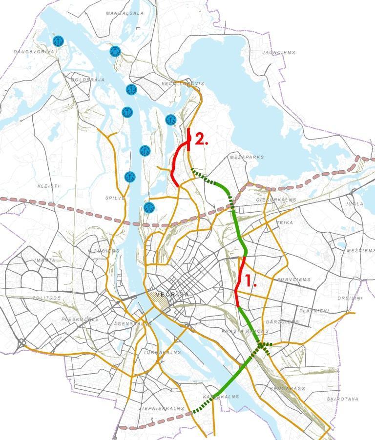
9 Research object 9 Ziemeļu street To city center To airport to Mārupe

10 Development plans Cargo and passenger growth 10 Territory development Expedition hall Business center
11 Input data (traffic flow intensity) 11

12 Input data (traffic light data) 12

13 Simulation model development PTV VISION VISSIM links and connectors 76 - conflict areas 5 traffic input point 2 public transport stops 1 public transport route 12 traffic lights > 100 3D objects 13

14 Particularities of the model Some directions are controlled by detectors 14
15 Scenarios Title Description 1 Scenario 1: P Intensity: Forecasted 2 Scenario 2: P+2J Intensity: Forecasted 2 lanes from Ziemeļu iela 3 Scenario 3: P+2J+L1 Intensity: Forecasted 2 lanes from Ziemeļu iela Fix traffic light cycle (1 st variant) 7 Scenario 7: P+2J+L2 Intensity: Forecasted 2 lanes from Ziemeļu iela Fix traffic light cycle (2nd variant) 11 Scenario 11: P175+2J+L3 15 Intensity: Forecasted (Marupe direction 175 v/h) 2 lanes from Ziemeļu iela Fix traffic light cycle (3rd variant)
16 Level of Service 16 LOS LOS Время задержки (с) Delay time (s) A 10 B > C > D >35 55 E > F >80
17 Simulation results 17 LOS Krustojums Virziens Braukšana 1 NB (Developing territory) EB (Airport) SB (Marupe) WB (City center) Left 2 Through Right 2 Scenāriji Total F F F F F E F F E D E Left 2 Through Right 1 Total C C C C C C D D D D D Left 2 Through Total F F F F F F E E E F E Left 2 Through Right 2 Total D D D D D D D D D D D Total F F F F E E E E E E E
18 Simulation results 18 Delay time, s

19 Simulation results 19 Average speed, km/h

20 3D animation 20
21 Case-study 2: pedestrian and transport flows analysis for pedestrian street creation in Riga 21 I R I N A Y A T S K I V E L E N A Y U R S H E V I C H M I H A I L S S A V R A S O V S
22 Goal: Pedestrian and transport flows analysis for pedestrian street creation in Riga city to test different development scenarios of the Terbatas street Tasks: to make a traffic counts survey to obtain information about current use of the street and around lying region; to estimate public transport loading level and to make public transport passenger questionnaire about origin, destination, travel goal and preferences; to develop and calibrate microscopic model, which describes current situations; to test different development scenarios; to forecast traffic flow redistribution and to estimate level of services (LOS) for crossroads according to HCM standard. 22
23 Traffic counts 23 Date and time: 29 September from 7:30 till 9:30 29 September from 16:30 till 18:30 Wednesday 30 September from 7:30 till 9:30 30 September 16:30 till 18:30 Thursday 150 TTI students (traffic counts) 10 students (data processing, analysis, visualization)

24 Object 37 Crossroads: 24 Brīvības iela Elizabetes iela Brīvības iela Dzirnavu iela Brīvības iela Blaumaņa iela Brīvības iela Lāčplēša iela Brīvības iela Ģertrūdes iela Brīvības iela Stabu iela Brīvības iela Bruņinieku iela Brīvības iela Matīsa iela Brīvības iela Tallinas iela Brīvības iela Cēsu iela Tērbatas iela Elizabetes iela Tērbatas iela Dzirnavu iela Tērbatas iela Blaumaņa iela Tērbatas iela Lāčplēša iela Tērbatas iela Ģertrūdes iela Tērbatas iela Stabu iela Tērbatas iela Bruņinieku iela Tērbatas iela Matīsa iela Tērbatas iela Tallinas iela Krišjāņa Barona iela Elizabetes iela Krišjāņa Barona iela Dzirnavu iela Krišjāņa Barona iela Blaumaņa iela Krišjāņa Barona iela Lāčplēša iela Krišjāņa Barona iela Ģertrūdes iela Krišjāņa Barona iela Stabu iela Krišjāņa Barona iela Bruņinieku iela Krišjāņa Barona iela Matīsa iela Krišjāņa Barona iela Tallinas iela Marijas iela Elizabetes iela Marijas iela Dzirnavu iela Aleksandra Čaka iela Blaumaņa iela Aleksandra Čaka iela Lāčplēša iela Aleksandra Čaka iela Ģertrūdes iela Aleksandra Čaka iela Stabu iela Aleksandra Čaka iela Bruņinieku iela Aleksandra Čaka iela Matīsa iela Aleksandra Čaka iela Tallinas iela

25 Traffic count results 25
26 Simulation Results (1/3) 26
")
27 Simulation Results (2/3) 27
28 Simulation Results (3/3) 28
29 Case-study 3: freight traffic flow research and rerouting from Riga city center 29 I R I N A Y A T S K I V M I H A I L S S A V R A S O V S I R I N A P T I C I N A I L Y A C I G R I N S N A D E Z H D A B O R O V I K O V A R I T A S T R O D E


30 Transport system 30 GDP 53%

31 Cargo turnover in Riga port 31
32 Cargo turnover by type 32


33 Average daily traffic flow intensity (2013) 33
34 Traffic counts 34 Date and time: 19 February from 10:00 till 12:00 19 February from 14:00 till 16:00 Wednesday 20 February from 10:00 till 12:00 20 February from 14:00 till 16:00 Thursday

35 Counted types of vehicles 35

36 Counting sites 19 counting sites: Vanšu tilts Akmens tilts Salu tilts Dienvidu tilts Maskavas iela Krasta iela 11. novembra krastmala Ziepniekkalna iela Mūkusalas iela Gustava Zemgale gatve Daugavgrīvas iela Raņķa dambis Slāvu iela Lubānas iela Hanzas iela Skanstes iela Vienības gatve Kārļa Ulmaņa gatve Viestura prospekts 36
37 Counting results (1/2) 37 Virziens: 5A / Maskavas iela (uz centru) Datums: (Transportlīdzekļu skaits) C4 C3 C2 C1 V
38 Counting results (2/2) 38 Virziens: 5A / Maskavas iela (uz centru) Datums: Transporta plūsmu struktura 3% 2% 0% 9% 86% V C1 C2 C3 C4
39 Total intensity
40 Total cargo flow intensity
41 Macromodel development nodes links 27 transport zones 2 OD matrix
42 Calibration and validation (1/2) 42
43 Calibration and validation R² = 0,

44 Scenario Changes in transport system Changes in traffic intensity 2014_B NO NO 2014_C1 Cargo flow restriction from Salu bridge to Hanzas iela NO 2014_C2 2014_C3 2014_VC1 2014_VC2 2014_VC3 Cargo flow restriction from Salu bridge to Hanzas iela and on Akmens bridge Cargo flow restriction from Salu bridge to Hanzas iela and on Akmens bridge and Sala bridge Transport flow restriction from Akmens bridge and Vanšu bridge Transport flow restriction from Turgeņeva street to Dzelzceļa bridge Transport flow restriction from Vanšu bridge Turgeņeva street NO NO All types of vehicles: - 5% All types of vehicles: - 5% All types of vehicles: - 5% 44

45 Project Austrumu maģistrāle 45
46 km/st Simulation results Scenārijs

47 Level of service (HCM) 47
48 Conclusions 48 Traffic flow simulation is a modern approach of TS quantitative analysis, which could be used for decision making Different types of models could be used in different level of decision making Use of model require prove of data validity, model validity, correctness of evaluation Use of standalone models is effective, but not for city authorities The important parts of DSS are: data collection procedures and technical implementation; database of the models; procedures of linkage different models issues related to data and model access
49 This work was supported by Latvian state research program project The next generation of information and communication technologies (NexIT) ( ) 49
Gdynia s bicycle model
 Gdynia s bicycle model Problems related to cycling network and demand modelling Michał Miszewski, city of Gdynia Development of tool for transport analysis - MST Statistical data (baseline and forecasts)
unsignalized signalized isolated coordinated Intersections roundabouts Highway Capacity Manual level of service control delay
 Whether unsignalized or signalized, isolated or coordinated, you can use TransModeler to simulate intersections with greater detail and accuracy than any other microsimulation software. TransModeler allows
MICROSIMULATION USING FOR CAPACITY ANALYSIS OF ROUNDABOUTS IN REAL CONDITIONS
 Session 5. Transport and Logistics System Modelling Proceedings of the 11 th International Conference Reliability and Statistics in Transportation and Communication (RelStat 11), 19 22 October 2011, Riga,
Introduction Roundabouts are an increasingly popular alternative to traffic signals for intersection control in the United States. Roundabouts have a
 HIGH-CAPACITY ROUNDABOUT INTERSECTION ANALYSIS: GOING AROUND IN CIRCLES David Stanek, PE and Ronald T. Milam, AICP Abstract. Roundabouts have become increasingly popular in recent years as an innovative
Low Level Road Improvements Traffic Analysis. Report
 Low Level Road Improvements Traffic Analysis Report June, 22 Table of Contents. INTRODUCTION.... LOW LEVEL ROAD PROJECT....2 STUDY AREA....2. West-End Corridor Improvements... 2.2.2 East-End Corridor Improvements...
A Traffic Operations Method for Assessing Automobile and Bicycle Shared Roadways
 A Traffic Operations Method for Assessing Automobile and Bicycle Shared Roadways A Thesis Proposal By James A. Robertson Submitted to the Office of Graduate Studies Texas A&M University in partial fulfillment
IMPACT OF TRANSIT SIGNAL PRIORITY (TSP) ON BUS TRAVEL TIMES, LATE BUS RECOVERY, DELAY AND LEVEL OF SERVICE (LOS)
 ON BUS TRAVEL TIMES, LATE BUS RECOVERY, DELAY AND LEVEL OF SERVICE (LOS)") IMPACT OF TRANSIT SIGNAL PRIORITY (TSP) ON BUS TRAVEL TIMES, LATE BUS RECOVERY, DELAY AND LEVEL OF SERVICE (LOS) Presenter: Sotonye Ikiriko 1, Deo Chimba 1 College of Engineering, Tennessee State University,
IMPACT OF TRANSIT SIGNAL PRIORITY (TSP) ON BUS TRAVEL TIMES, LATE BUS RECOVERY, DELAY AND LEVEL OF SERVICE (LOS) Presenter: Sotonye Ikiriko 1, Deo Chimba 1 College of Engineering, Tennessee State University,
DUNBOW ROAD FUNCTIONAL PLANNING
 DUNBOW ROAD FUNCTIONAL PLANNING Final Report August 3, 216 #31, 316 5th Avenue NE Calgary, AB T2A 6K4 Phone: 43.273.91 Fax: 43.273.344 wattconsultinggroup.com Dunbow Road Functional Planning Final Report
Intersection LOS Intersection level of service (LOS) is defined by the Highway Capacity Manual (HCM) by the following criteria:
 is defined by the Highway Capacity Manual (HCM) by the following criteria:") Page 2 of 9 Intersection LOS Intersection level of service (LOS) is defined by the Highway Capacity Manual (HCM) by the following criteria: Table 1 LOS Definitions Level of Signalized Un-Signalized Definition
Page 2 of 9 Intersection LOS Intersection level of service (LOS) is defined by the Highway Capacity Manual (HCM) by the following criteria: Table 1 LOS Definitions Level of Signalized Un-Signalized Definition
DRAFT. Memo. Range of the Alternatives Considered in the EIS
 Memo Date: Friday, December 09, 2016 Project: To: From: Subject: State Route 30 EIS UDOT Vince Izzo This memorandum summarizes the draft State Route (S.R.) 30 Level 1 screening results. A more detailed
Appendix B: Forecasting and Traffic Operations Analysis Framework Document
 Existing Conditions Report - Appendix Appendix B: Forecasting and Traffic Operations Analysis Framework Document This document defines the methodology and assumptions that will be used in the traffic forecasting
Simulating Street-Running LRT Terminus Station Options in Dense Urban Environments Shaumik Pal, Rajat Parashar and Michael Meyer
 Simulating Street-Running LRT Terminus Station Options in Dense Urban Environments Shaumik Pal, Rajat Parashar and Michael Meyer Abstract The Exposition Corridor transit project is a light rail project
IMPACTS OF TRAFFIC RESTRICTIONS AND INFRASTRUCTURE IMPROVEMENTS ON DOWNTOWN PEAK HOUR CONGESTION: A SYNCHRO ANALYSIS FOR BELLEVUE, WASHINGTON
 Final Technical Report TNW2009-06 IMPACTS OF TRAFFIC RESTRICTIONS AND INFRASTRUCTURE IMPROVEMENTS ON DOWNTOWN PEAK HOUR CONGESTION: A SYNCHRO ANALYSIS FOR BELLEVUE, WASHINGTON Chris Masek, P.E. Nancy Nihan,
Enabling Automation-Ready Transport Planning
 Enabling Automation-Ready Transport Planning Road Authorities Road Infrastructure Transport Modelling This project has received funding from the European Union s Horizon 2020 research and innovation programme
Canada s Capital Region Delegation to the Velo-City Global 2010 Conference
 Canada s Capital Region Delegation to the Velo-City Global 2010 Conference Report of Findings from Visits, Meetings & Presentations In Amsterdam-Den Haag, Utrecht, Berlin & Copenhagen The Itinerary Copenhagen
Corridor Studies. LA 415 and LA 73
 Corridor Studies LA 415 and LA 73 Project Approach for Both Corridors 1. Data Collection 2. Data Summary 3. Traffic Analysis 4. Micro-Simulation modeling 5. Generation of alternatives 6. Modeling alternatives
Volume-to-Capacity Estimation of Signalized Road Networks for Metropolitan Transportation Planning
 Volume-to-Capacity Estimation of Signalized Road Networks for Metropolitan Transportation Planning Hao Xu (Corresponding Author) Research Associate Department of Civil & Environmental Engineering Texas
5858 N COLLEGE, LLC N College Avenue Traffic Impact Study
 5858 N COLLEGE, LLC nue Traffic Impact Study August 22, 2016 Contents Traffic Impact Study Page Preparer Qualifications... 1 Introduction... 2 Existing Roadway Conditions... 5 Existing Traffic Conditions...
Proposed Trial of Lane Reduction on Highway 19A (McMillan Corfield) City of Parksville Town Hall Meeting
 City of Parksville Town Hall Meeting") Proposed Trial of Lane Reduction on Highway 19A (McMillan Corfield) City of Parksville Town Hall Meeting October 21 st, 2013 On August 7, 2013, Council directed staff to forward the following topic to
Proposed Trial of Lane Reduction on Highway 19A (McMillan Corfield) City of Parksville Town Hall Meeting October 21 st, 2013 On August 7, 2013, Council directed staff to forward the following topic to
Balancing Operation & Safety for Motorized and Non-Motorized Traffic
 Balancing Operation & Safety for Motorized and Non-Motorized Traffic Brian Willham, PE, PTOE Iowa Director - MOVITE June 30, 2014 Learning Objectives: When & Why should we measure the performance of complete
Traffic Impact Analysis Walton Acres at Riverwood Athletic Club Clayton, NC
 Traffic Impact Analysis Walton Acres at Riverwood Athletic Club Clayton, NC 1. TABLE OF CONTENTS INTRODUCTION...1 1.1. Site Location and Study Area...1 1.2. Proposed Land Use and Site Access...2 1.3.
Chapter 4 Traffic Analysis
 Chapter 4 Traffic Analysis PURPOSE The traffic analysis component of the K-68 Corridor Management Plan incorporates information on the existing transportation network, such as traffic volumes and intersection
WELCOME TO OPEN HOUSE # 1 June 14, 2017
 Langstaff Road Weston Road to Highway 7 Class Environmental Assessment Study WELCOME TO OPEN HOUSE # 1 June 14, 2017 Please sign in and join our mailing list Purpose of Open House #1 & Study Area York
Community Advisory Committee
 Community Advisory Committee Meeting #1 November 19, 2014 Presentation Team Matt Fulda, Greater Bridgeport Regional Council Chris Granatini, P.E., Tighe & Bond Craig Yannes, P.E., PE PTOE, Tighe & Bond
2. Context. Existing framework. The context. The challenge. Transport Strategy
 Transport Strategy Providing quality connections Contents 1. Introduction 2. Context 3. Long-term direction 4. Three-year priorities 5. Strategy tree Wellington City Council July 2006 1. Introduction Wellington
The FLOW Approach in Munich. Johannes Keller City of Munich, Department of Urban Planning and Building Regulation
 The FLOW Approach in Munich Johannes Keller City of Munich, Department of Urban Planning and Building Regulation 2 Local FLOW case study: Art Boulevard Arcisstrasse Located in the Munich Art District Result
Traffic Impact Analysis Chatham County Grocery Chatham County, NC
 Chatham County Grocery Chatham County, NC TABLE OF CONTENTS 1. INTRODUCTION... 1 1.1. Location and Study Area... 1 1.2. Proposed Land Use and Access... 2 1.3. Adjacent Land Uses... 2 1.4. Existing ways...
Integrated Pedestrian Simulation in VISSIM
 Integrated Pedestrian Simulation in VISSIM PTV worldwide MUGS Conference October 30-31, 2008 Wellington Founded > 1979 30 years fast approaching Employees > Approximately 800 persons in the PTV Group worldwide
SOFTWARE, DATA & PROCESSES TO INCREASE ROAD SAFETY IN CITIES
 SOFTWARE, DATA & PROCESSES TO INCREASE ROAD SAFETY IN CITIES Timo Hoffmann, PTV Group 2014-02-11 istockphoto/ Michal Krakowiak THE TRANSPORTATION CHALLENGES OF TODAY AND TOMORROW Transportation Urbanization
EVALUATION OF PERFORMANCE OF MODERN ROUNDABOUTS USING PARAMICS MICRO-SIMULATION MODEL
 Oketch, Delsey and Robertson 1 Paper Title: EVALUATION OF PERFORMANCE OF MODERN ROUNDABOUTS USING PARAMICS MICRO-SIMULATION MODEL Authors: Timothy Oketch, Ph.D., P. Eng., Project Manager*; Mike Delsey,
Traffic Impact Study WestBranch Residential Development Davidson, NC March 2016
 Traffic Impact Study WestBranch Residential Development Davidson, NC March 216 TRAFFIC IMPACT STUDY FOR THE WestBranch Residential Development LOCATED IN DAVIDSON, NC Prepared For: Lennar Carolinas, LLC
Analysis of Signalized Intersections
 Analysis of Signalized Intersections What is Intersection analysis Inverse application of the signal timing design In signal timing design, green times are estimated to provide necessary capacity In intersection
William Castro Associated Professor, Faculty of Engineering, Universidad Nacional de Colombia Bogotá, Colombia,
 ANALYSIS AND COMPARISON BETWEEN TWO-LANE ROUNDABOUTS AND TURBO ROUNDABOUTS BASED ON A ROAD SAFETY AUDIT METHODOLOGY AND MICROSIMULATION: A CASE STUDY IN URBAN AREA Lenin A. Bulla Associated Professor,
LOOP 360 IMPROVEMENT STUDY
 LOOP 360 IMPROVEMENT STUDY Overview and Preliminary Analysis August 2015 1 STUDY PROCESS 2 Study Background Loop 360 serves a wide range of users, including residents, businesses, bicyclists, and commuters
Complete Street Analysis of a Road Diet: Orange Grove Boulevard, Pasadena, CA
 Complete Street Analysis of a Road Diet: Orange Grove Boulevard, Pasadena, CA Aaron Elias, Bill Cisco Abstract As part of evaluating the feasibility of a road diet on Orange Grove Boulevard in Pasadena,
University of California, Davis Transit Signal Priority Implementation Study
 Proposal University of California, Davis Transit Signal Priority Implementation Study Prepared for: Prepared by: University of California, Davis 2990 Lava Ridge Court Suite 200 Roseville, CA 95661 November
THIS PAGE LEFT BLANK INTENTIONALLY
 GA SR 25 Spur at Canal Road Transportation Impact Analysis PREPARED FOR GLYNN COUNTY, GEORGIA 1725 Reynolds Street, Suite 300 Brunswick, Georgia 31520 PREPARED BY 217 Arrowhead Boulevard Suite 26 Jonesboro,
Title Option One. Operations and Safety of Separated Bicycle Facilities at Single Lane Roundabouts
 Title Option One Operations and Safety of Separated Bicycle Facilities at Single Lane Roundabouts David Stanek, PE Institute of Transportation Engineers Western District Annual Meeting San Diego, CA June
ANALYSIS OF SATURATION FLOW RATE FLUCTUATION FOR SHARED LEFT-TURN LANE AT SIGNALIZD INTERSECTIONS *
 ANALYSIS OF SATURATION FLOW RATE FLUCTUATION FOR SHARED LEFT-TURN LANE AT SIGNALIZD INTERSECTIONS * By Peng CHEN**, Hideki NAKAMURA*** and Miho ASANO**** 1. Introduction In urban corridor performance evaluation,
Place Vanier 250 Montreal Road Transportation Impact Study Addendum. Prepared for Broccolini Construction September 20 th, 2012
 Update for the May 31 st, 2012 Traffic Impact Study Prepared for Broccolini Construction 111-23596-00 September 20 th, 2012 2611 Queensview Drive, Suite 300, Ottawa, Ontario CANADA K2B 8K2 Telephone: 613-829-2800
Diverging Diamond Interchange and Double Crossover Intersection Vehicle and Pedestrian Performance
 Diverging Diamond Interchange and Double Crossover Intersection Vehicle and Pedestrian Performance Praveen K. Edara, Department of Civil and Environmental Engineering, Virginia Polytechnic Institute and
3.9 - Transportation and Traffic
 Transportation and Traffic 3.9 - Transportation and Traffic This section describes the potential transportation and traffic effects of project implementation on the project site and its surrounding area.
Traffic Signal Redesign 50% Design Report
 Traffic Signal Redesign 50% Design Report Joseph Davis, Jace Elkins, Jordan Weyrauch and Zach Crimmins CENE 486 Capstone J3Z Engineering March 10 th, 2016 Table of Contents 1.0 Project Description...1
NO BUILD TRAFFIC OPERATIONS
 3. 23 NO BUILD TRAFFIC OPERATIONS This section addresses the operations of the transportation system and details how it would be expected to function under year 23 No Build conditions with the projected
SUMP in Emilia Romagna Region and the national level»
 Local Public Transport and Sustainable Mobility Department SUMP in Emilia Romagna Region and the national level» Andrea Normanno Eleonora Tu SUMP in Europe: best practices and multi-level governance The
HCM Sixth Edition. Plus More. Rahim (Ray) Benekohal University of Illinois at Urban Champaign,
 Benekohal University of Illinois at Urban Champaign,") HCM Sixth Edition What s New in the HCM Sixth Edition Plus More Rahim (Ray) Benekohal University of Illinois at Urban Champaign, 65 th Traffic Engineering and Safety Conference October 19 20, 2016 Institute
HCM Sixth Edition What s New in the HCM Sixth Edition Plus More Rahim (Ray) Benekohal University of Illinois at Urban Champaign, 65 th Traffic Engineering and Safety Conference October 19 20, 2016 Institute
Modelling Pedestrian Circulation in Rail Transit Stations Using Micro-Simulation
 Modelling Pedestrian Circulation in Rail Transit Stations Using Micro-Simulation ATRF 2009 Venue: Auckland, New Zealand Date: September 30, 2009 Galiza*/Kim**/Ferreira*/Laufer** *University of Queensland
Chapter 5 5. INTERSECTIONS 5.1. INTRODUCTION
 Chapter 5 5. INTERSECTIONS 5.1. INTRODUCTION Intersections are the physical component of the roadways where two highways intersect. They are the most complex element of roadways, since it requires more
Land at Chesterton, Cirencester
 Land at Chesterton, Cirencester Transport Update 22 October 2014 By Mark Gimingham BA (Hons) BTP CMILT MCIHT, Partner, i-transport LLP Purpose To provide an update on progress with the development of the
Performance Criteria for 2035 Long Range Transportation Plan
 Minimizing Impacts on Natural, Historic, Cultural or Archeological Resources 2035 LRTP Weighting Factor: 7% Objective 1.1: Use appropriate planning and design criteria to protect and enhance the built
LEVEL CROSSING SAFETY CAMPAIGN IN CROATIA
 Danijela Barić University of Zagreb, Faculty of Transport and Traffic Sciences LEVEL CROSSING SAFETY CAMPAIGN IN CROATIA Madrid, 10 October 2018 LCs ON THE CROATIAN RAILWAYS RAILWAYS NETWORK: 2,605km of
PRELIMINARY DRAFT WADDLE ROAD / I-99 INTERCHANGE PROJECT ALTERNATIVE ANALYSIS FINAL TRAFFIC SUMMARY REPORT
 PRELIMINARY DRAFT WADDLE ROAD / I-99 INTERCHANGE PROJECT ALTERNATIVE ANALYSIS FINAL TRAFFIC SUMMARY REPORT Prepared by: In Association with: November 2013 EXECUTIVE SUMMARY Patton Township, in partnership
Unit 7 Speed, Travel Time and Delay Studies
 Unit 7 Speed, Travel Time and Delay Studies Introduction Speed, travel time and delay are all related measures that are common used as indicators of performance for traffic facilities Measure of Effectiveness
3.2.2 Proposed Road Network within Phase 1B Lands
 3.2.2 Proposed Road Network within Phase 1B Lands Figure 3.1 also shows the proposed road network within the Premier Gateway Phase 1B Employment Area lands, which features two collector roads providing
2045 Long Range Transportation Plan. Summary of Draft
 2045 Long Range Transportation Plan Summary of Draft Fredericksburg Area Metropolitan Planning Organization The George Washington Region includes the City of Fredericksburg and the counties of Caroline,
Arterial Management Plan for US Route 250 and State Route 623
 Arterial Management Plan for US Route 250 and State Route 623 June 25, 2014 Brad Shelton, AICP Access Management and Traffic Impact Analysis Programs Manager Transportation and Mobility Planning Division
Welcome. The Brooklin Secondary Plan and Transportation Master Plan are collectively referred to as the Brooklin Study.
 Welcome The Town of Whitby is undertaking a study to prepare a Secondary Plan and Transportation Master Plan to guide and manage growth in the Brooklin area. The Brooklin Secondary Plan and Transportation
PTV VISUM SAFETY SMART SAFETY AND TRAFFIC CONTROL FOR SMART CITIES
 PTV VISUM SAFETY SMART SAFETY AND TRAFFIC CONTROL FOR SMART CITIES www.ptvag.com www.ptvgroup.com Page 1 THE TWO PROBLEMS 1. TRAFFIC CONGESTION 2. ROAD ACCIDENTS www.ptvgroup.com KEY FACTS Traffic Index
Operational Comparison of Transit Signal Priority Strategies
 Operational Comparison of Transit Signal Priority Strategies Revision Submitted on: November, 0 Author: Adriana Rodriguez, E.I Assistant Engineer Parsons Brinckerhoff 0 South Orange Avenue, Suite 00 Orlando,
Module 3 Developing Timing Plans for Efficient Intersection Operations During Moderate Traffic Volume Conditions
 Module 3 Developing Timing Plans for Efficient Intersection Operations During Moderate Traffic Volume Conditions CONTENTS (MODULE 3) Introduction...1 Purpose...1 Goals and Learning Outcomes...1 Organization
Figure 1: East West Connector Alignment Alternatives Concept Drawing
 Page 2 of 9 Figure 1: East West Connector Alignment Alternatives Concept Drawing The Montebello Drive extension will run north south and connect Wilsonville Road to the Boones Ferry Road to Brown Road
A Comparative Analysis of Roundabouts and Traffic Signals through a Corridor
 Louisiana State University LSU Digital Commons LSU Master's Theses Graduate School 2015 A Comparative Analysis of Roundabouts and Traffic Signals through a Corridor Melissa Arrigo LeBas Louisiana State
Time Based Traffic Signal Coordination (A Case Study of Gatthaghar and Naya Thimi Intersections)
") pp. 48 54 Time Based Traffic Signal Coordination (A Case Study of Gatthaghar and Naya Thimi Intersections) Binayak Bhattarai 1 *, Anil Marsani 2 1 Graduate Student, M.Sc. in Transportation Engineering,
pp. 48 54 Time Based Traffic Signal Coordination (A Case Study of Gatthaghar and Naya Thimi Intersections) Binayak Bhattarai 1 *, Anil Marsani 2 1 Graduate Student, M.Sc. in Transportation Engineering,
Roundabout Model Calibration Issues and a Case Study
 Roundabout Model Calibration Issues and a Case Study TRB National Roundabout Conference Vail, Colorado, USA, 22-25 May 2005 Pictures modified to show driving on the right-hand side of the road Rahmi Akçelik
SUMP of Ravenna: relevant experiences on travel behavior change
 SUMP of Ravenna: relevant experiences on travel behavior change Nicola Scanferla, Head of Mobility Planning Unit Giorgia Rambaldi, Mobility Planning Unit nscanferla@comune.ra.it giorgiarambaldi@comune.ravenna.it
I-95 Northbound at US 1 (Exit 126) Design and Study Final Report
 Design and Study Final Report") I-95 Northbound at US 1 (Exit 126) Design and Study Final Report July 2018 Prepared by: Prepared for: TABLE OF CONTENTS 1 Introduction... 1 Study Area Limits... 1 Purpose and Need of the Study... 1 Safety
I-95 Northbound at US 1 (Exit 126) Design and Study Final Report July 2018 Prepared by: Prepared for: TABLE OF CONTENTS 1 Introduction... 1 Study Area Limits... 1 Purpose and Need of the Study... 1 Safety
Tulsa Metropolitan Area LONG RANGE TRANSPORTATION PLAN
 Tulsa Metropolitan Area LONG RANGE TRANSPORTATION PLAN Indian Nations Council of Governments August 2005 CONTACTING INCOG In developing the Destination 2030 Long Range Transportation Plan, INCOG s Transportation
Financial Project ID No(s).: and ETDM No(s).: and 14181
.: and ETDM No(s).: and 14181") Palm Beach Metropolitan Planning Organization (MPO) Presentation I-95 at Boynton Beach Boulevard Interchange and I-95 at Gateway Boulevard Interchange Project Development and Environment Study Palm Beach
Palm Beach Metropolitan Planning Organization (MPO) Presentation I-95 at Boynton Beach Boulevard Interchange and I-95 at Gateway Boulevard Interchange Project Development and Environment Study Palm Beach
Operational Ranking of Intersections: A Novel Prioritization Methodology
 Operational Ranking of Intersections: A Novel Prioritization Methodology Reza Omrani, Ph.D. Transportation Engineer CIMA+ 3027 Harvester Road, Suite 400 Burlington, ON L7N 3G7 Reza.Omrani@cima.ca Pedram
February 8, Ms. Jamie Jun, Esq. Fromhold Jaffe & Adams 789 East Lancaster Avenue, Suite 220 Villanova, PA 19085
 WWW.TRAFFICPD.COM February 8, 2016 Ms. Jamie Jun, Esq. Fromhold Jaffe & Adams 789 East Lancaster Avenue, Suite 220 Villanova, PA 19085 Re: Kohelet Yeshiva School Lower Merion Township, Montgomery County,
ENHANCED PARKWAY STUDY: PHASE 2 CONTINUOUS FLOW INTERSECTIONS. Final Report
 Preparedby: ENHANCED PARKWAY STUDY: PHASE 2 CONTINUOUS FLOW INTERSECTIONS Final Report Prepared for Maricopa County Department of Transportation Prepared by TABLE OF CONTENTS Page EXECUTIVE SUMMARY ES-1
3. EXISTING TRANSPORTATION CONDITIONS
 3. EXISTING TRANSPORTATION CONDITIONS Eglinton Avenue spans 35 kilometres across the centre of Toronto, from Kingston Road near Lake Ontario in the east to the Pearson Airport in the west. The corridor
Design and Evaluation of Adaptive Traffic Control System for Heterogeneous flow conditions
 Design and Evaluation of Adaptive Traffic Control System for Heterogeneous flow conditions Tom Mathew IIT Bombay Outline 1. Heterogeneous traffic 2. Traffic Simulation 3. Traffic Signal control 4. Adaptive
Traffic: an Interplay between Models, Simulations, and Control Actions
 Traffic: an Interplay between Models, Simulations, and Control Actions Sven Maerivoet DWTC Katholieke Universiteit Leuven Department of Electrical Engineering ESAT-SCD (SISTA) Friday Seminar 05/03/2004
Lane changing and merging under congested conditions in traffic simulation models
 Urban Transport 779 Lane changing and merging under congested conditions in traffic simulation models P. Hidas School of Civil and Environmental Engineering, University of New South Wales, Australia Abstract
City of Hamilton s Transportation Master Plan (TMP) Public Consultation 3 December 2015
 Public Consultation 3 December 2015") City of Hamilton s Transportation Master Plan (TMP) Public Consultation 3 December 2015 McPhail Transportation Planning Services Ltd. AGENDA 6:00 7:00 pm Viewing Boards / Q & A with the Team 7:00 7:50
City of Hamilton s Transportation Master Plan (TMP) Public Consultation 3 December 2015 McPhail Transportation Planning Services Ltd. AGENDA 6:00 7:00 pm Viewing Boards / Q & A with the Team 7:00 7:50
Traffic Impact Study Little Egypt Road Development Denver, North Carolina June 2017
 Traffic Impact Study Little Egypt Road Development Denver, North arolina June 2017 N. Little Egypt Road DQ\ QDQFLQJ VDOHV RU RWKHU SHUIRUPDQFH EDVHG FULWHULD Proposed Site Driveways Site Driveway 1 TRAFFI
Transportation Master Plan Advisory Task Force
 Transportation Master Plan Advisory Task Force Network Alternatives & Phasing Strategy February 2016 BACKGROUND Table of Contents BACKGROUND Purpose & Introduction 2 Linking the TMP to Key Council Approved
Walmart (Store # ) 60 th Street North and Marion Road Sioux Falls, South Dakota
 60 th Street North and Marion Road Sioux Falls, South Dakota") Walmart (Store #4865-00) 60 th Street North and Marion Road Sioux Falls, South Dakota Prepared for: Wal-Mart Stores, Inc. Bentonville, Arkansas Prepared by: Kimley-Horn and Associates, Inc. ã2013 Kimley-Horn
Walmart (Store #4865-00) 60 th Street North and Marion Road Sioux Falls, South Dakota Prepared for: Wal-Mart Stores, Inc. Bentonville, Arkansas Prepared by: Kimley-Horn and Associates, Inc. ã2013 Kimley-Horn
Transport Assessment & Traffic Modelling Report
 Transport Assessment & Traffic Modelling Report Additional Traffic Modelling for Glanmire / Dunkettle to facilitate a signalised junction with Dunkettle Road from Ballinglanna Lands. MHL & Associates Ltd,,
Konstantin Glukhenkiy Economic Affairs Officer
 Konstantin Glukhenkiy Economic Affairs Officer Rapid growth of urban areas Very rapid increase in motorisation Substantial increases in traffic congestion Relative decline of public transport usage and
Glenn Avenue Corridor Traffic Operational Evaluation
 Glenn Avenue Corridor Traffic Operational Evaluation PREPARED FOR: THE CITY OF AUBURN PREPARED BY: DECEMBER 2007 Glenn Avenue Corridor Study--Auburn, Alabama TABLE OF CONTENTS Introduction... 1 Background
MAG Town of Cave Creek Bike Study Task 6 Executive Summary and Regional Significance Report
 Page 1 MAG Town of Cave Creek Bike Study Task 6 Executive Summary and Regional Significance Report August 1, 2012 MAG Project #481 Page 2 Task 6 Executive Summary and Regional Significance Report Introduction
Economic and Social Council
 United Nations Economic and Social Council ECE/TRANS/WP.5/2016/4 Distr.: General 27 June 2016 Original: English Economic Commission for Europe Inland Transport Committee Working Party on Transport Trends
Traffic Analysis Report No-Build Conditions (2040)
") Traffic Analysis Report No-Build Conditions (2040) LA 23 New Orleans Gulf Coast Railway Relocation PE/NEPA Project Jefferson and Plaquemines Parishes, Louisiana RPC Task LA23RR1 RPC/FRA Grant # FR-RLD-0032-14-01-00
Traffic Analysis Report No-Build Conditions (2040) LA 23 New Orleans Gulf Coast Railway Relocation PE/NEPA Project Jefferson and Plaquemines Parishes, Louisiana RPC Task LA23RR1 RPC/FRA Grant # FR-RLD-0032-14-01-00
Simulation of Arterial Traffic Using Cell Transmission Model
 1 Simulation of Arterial Traffic Using Cell Transmission Model Dongyan Su University of California, Berkeley 2167c Etcheverry Hall, University of California, Berkeley, CA 94720-1740 Tel: 1-510-928-8771,
Table of Contents FIGURES TABLES APPENDICES. Traffic Impact Study Hudson Street Parking Garage MC Project No.: A Table of Contents
 Traffic Impact Study Hudson Street Parking Garage MC Project No.: 151714A Table of Contents Table of Contents I. INTRODUCTION... 2 II. EXISTING CONDITIONS... 5 III. 215 EXISTING TRAFFIC CONDITIONS... 6
DOI /HORIZONS.B P23 UDC : (497.11) PEDESTRIAN CROSSING BEHAVIOUR AT UNSIGNALIZED CROSSINGS 1
 PEDESTRIAN CROSSING BEHAVIOUR AT UNSIGNALIZED CROSSINGS 1") DOI 10.20544/HORIZONS.B.03.1.16.P23 UDC 656.142.054:159.922(497.11) PEDESTRIAN CROSSING BEHAVIOUR AT UNSIGNALIZED CROSSINGS 1 JelenaMitrovićSimić 1, Valentina Basarić, VukBogdanović Department of Traffic
DOI 10.20544/HORIZONS.B.03.1.16.P23 UDC 656.142.054:159.922(497.11) PEDESTRIAN CROSSING BEHAVIOUR AT UNSIGNALIZED CROSSINGS 1 JelenaMitrovićSimić 1, Valentina Basarić, VukBogdanović Department of Traffic
Subject: Solberg Avenue / I-229 Grade Separation: Traffic Analysis
 MEMORANDUM Transportation Bill Troe, AICP Jason Carbee, AICP 12120 Shamrock Plaza Suite 300 Omaha, NE 68154 (402) 334-8181 (402) 334-1984 (Fax) To: Project File Date: Subject: Solberg Avenue / I-229 Grade
Pedestrian Dynamics: Models of Pedestrian Behaviour
 Pedestrian Dynamics: Models of Pedestrian Behaviour John Ward 19 th January 2006 Contents Macro-scale sketch plan model Micro-scale agent based model for pedestrian movement Development of JPed Results
ADOT Statewide Bicycle and Pedestrian Program Summary of Phase IV Activities APPENDIX B PEDESTRIAN DEMAND INDEX
 ADOT Statewide Bicycle and Pedestrian Program Summary of Activities APPENDIX B PEDESTRIAN DEMAND INDEX May 24, 2009 Pedestrian Demand Index for State Highway Facilities Revised: May 29, 2007 Introduction
Summarize and compare traffic model results for two scenarios 2030 As Is 2030 Jensen Connection
 Parksville Downtown Purpose Summarize and compare traffic model results for two scenarios 2030 As Is 2030 Jensen Connection Show road dieting options for Island Highway that will not reduce lanes BEFORE
Aspects Regarding Priority Settings in Unsignalized Intersections and the Influence on the Level of Service
 Aspects Regarding Priority Settings in Unsignalized Intersections and the Influence on the Level of Service Dumitru Ilie, Matei Lucian, Vînatoru Matei, Racilă Laurențiu and Oprica Theodor Abstract The
Design Traffic Technical Memorandum
 State Road 7 Extension PD&E Study Design Traffic Technical Memorandum Palm Beach County, FL October 2010 State Road 7 Extension PD&E Study Design Traffic Technical Memorandum Palm Beach County, FL Prepared
Harrah s Station Square Casino
 Transportation Analysis Harrah s Station Square Casino Pittsburgh, Pennsylvania Submitted To: City of Pittsburgh and Pennsylvania Gaming Control Board Prepared By: DKS Associates GAI Consultants December
Green mobility and traffic safety in Copenhagen
 Green mobility and traffic safety in Copenhagen / Steffen Rasmussen, Head of Projects City of Copenhagen The Technical and Environmental Administation 15 September 2018 Dramatic development over the last
Operational Performance Comparison between Three Unconventional Intersection Designs: Left-turn Bypass, Diverging Flow and Displaced Left-turn
 Ninth LACCEI Latin American and Caribbean Conference (LACCEI 2011), Engineering for a Smart Planet, Innovation, Information Technology and Computational Tools for Sustainable Development, August 3-5, 2011,
IRIS 2 MOBILITY PLAN Brussels-Capital Region
 IRIS 2 MOBILITY PLAN Brussels-Capital Region Rosario October 2016 Wanda DEBAUCHE Head of Division Mobility-Safety-Road Management PLAN Our organisation The context : Who, Why, How? How do we travel today
Traffic Signal Optimization Project (Hosman Road) (Future Coordinated Corridor)
 (Future Coordinated Corridor)") Onondaga County Department of Transportation Traffic Signal Optimization Project (Hosman Road) (Future Coordinated Corridor) Prepared for: Syracuse Metropolitan Transportation Council 126 North Salina
Onondaga County Department of Transportation Traffic Signal Optimization Project (Hosman Road) (Future Coordinated Corridor) Prepared for: Syracuse Metropolitan Transportation Council 126 North Salina
Titolo presentazione sottotitolo
 A Decision Support System to plan bike mobility interventions Titolo presentazione sottotitolo Laboratorio Mobilità e Trasporti - Politecnico di Milano Luca Studer, Marco Ponti, Maurizio Bruglieri Milano,