REGIONAL BICYCLE NETWORK GAP ANALYSIS
|
|
|
- Ann Weaver
- 5 years ago
- Views:
Transcription


1

2 REGIONAL BICYCLE NETWORK GAP ANALYSIS UPWP Task: RTC Contract No: Prepared for: 600 S. Grand Central Parkway Suite 350 Las Vegas, Nevada Prepared by: 6671 Las Vegas Boulevard South Suite 320 Las Vegas, Nevada May 2014 KHA Project Number: Copyright 2014 Kimley-Horn and Associates, Inc. Page i
3 ACKNOWLEDGEMENTS The Regional Transportation Commission of Southern Nevada and the Technical Working Group members were instrumental in the development, review and refinement of this study. The Regional Transportation Commission and Kimley-Horn and Associates, Inc. would like to express their appreciation to the Technical Working Group members and their supporting staff for their participation and contributions. Regional Transportation Commission Philip Banea Ron Floth Raymond Hess Martyn James Andrew Kjellman Aileen Pastor Julie Schaller Amber Stidham Consultant Team Molly O Brien Mike Colety Devin Moore Shari Yagodnik Technical Working Group Members Derek Allen, City of Henderson Joe Fenster, City of Henderson Scott Jarvis, City of Henderson Randy Fultz, City of Las Vegas Greg McDermott, City of Las Vegas Johanna Murphy, City of North Las Vegas Scott Hagen, Clark County Sherie Moore, Clark County School District Cleveland Dudley, Nevada Department of Transportation Rae Lathrop, Outside Las Vegas Foundation Mindy Meacham, Southern Nevada Health District The preparation of this report has been financed in part through grant(s) from the Federal Highway Administration and Federal Transit Administration, U.S. Department of Transportation, under the Metropolitan Planning Program, Section 104(f) of Title 23, U.S. Code. The contents of this report do not necessarily reflect the official views or policy of the U.S. Department of Transportation. Page ii
4 TABLE OF CONTENTS 1. EXECUTIVE SUMMARY Purpose Study Area Project Overview Research Previous Studies and Plans Update RTC Bicycle Network Inventory Database Identify Network Connection Points Identify Gap Locations Prioritize Gap Locations Develop Preliminary Recommendations for Infrastructure Improvements Prepare Draft Regional Bicycle Network Revise Draft Regional Bicycle Network Conceptual Cost Estimates by Category Final Report and Regional Bicycle Network Map High Priority Recommendations INTRODUCTION Purpose Study Area Project Overview Research Previous Studies and Plans Update RTC Bicycle Network Inventory Database Identify Network Connection Points Identify Gap Locations Prioritize Gap Locations... 7 Page iii
5 TABLE OF CONTENTS Develop Preliminary Recommendations for Infrastructure Improvements Prepare Draft Regional Bicycle Network Revise Draft Regional Bicycle Network Conceptual Cost Estimates by Category Final Report and Regional Bicycle Network Map DATA COLLECTION Geodatabase Existing Bicycle Network Inventory DATA ANALYSIS Demand Score Population Density Employment Density Total Demand Score Connectivity Score Connectivity Score Step # Connectivity Score Step # Connectivity Score Step # Connectivity Score Step # Additional Identification of Gaps Total Connectivity Score PRIORITIZATION SCORING AND METHODOLOGY Demand-Connectivity Matrix Results HIGH PRIORITY RECOMMENDATIONS Page iv
6 TABLE OF CONTENTS LIST OF APPENDICES A B C D Conceptual Cost Estimates Public Input TWG Review Comments Additional Factors for Consideration in the RTC Bicycle and Pedestrian Plan Update LIST OF FIGURES Figure E1 High Priority Recommendations Map... 5 Figure 1 Existing Bicycle Facility Inventory... 9 Figure 2 Connectivity Score Step # Figure 3 Connectivity Score Step # Figure 4 Connectivity Score Step # Figure 5 Connectivity Score Step #4... Figure 6 Demand-Connectivity Matrix Scoring Theory Figure 7 Demand-Connectivity Matrix Figure 8 Demand-Connectivity Map Figure 9 High Priority Recommendations Map Figure 10 High Priority Recommendations Map with Regional Routes Highlighted Figure 11 Proposed Regional Routes with Proposed Route Numbering LIST OF TABLES Table 1 Demand Score per Segment Table A1 Conceptual Cost Estimates Table B1 Summary of Public Review Comments on Draft Report Table C1 Summary of TWG Comments on Draft Report Page v
7 LIST OF ACRONYMS AASHTO AADT CC CLV CNLV DETR GILIS GIS GISMO MUTCD NACTO RTC TWG American Association of State Highway and Transportation Officials Average Annual Daily Traffic Clark County City of Las Vegas City of North Las Vegas Department of Employment, Training and Rehabilitation Geographically Integrated Land Use Information System Geographic Information Systems Geographic Information Systems Management Office Manual on Uniform Traffic Control Devices National Association of City Transportation Officials Regional Transportation Commission Technical Working Group Page vi
8 1. EXECUTIVE SUMMARY The following sections describe the purpose, study area, and provide a brief project overview for the Regional Bicycle Network Gap Analysis for the Las Vegas Valley Purpose The purpose of this study is to determine where critical gaps exist in the bicycle network and evaluate locations where bicycle facilitates are needed to connect in order to allow users to seamlessly ride their bicycles to key destinations throughout the Las Vegas Valley. The high priority recommendations to fill the critical gaps are based on the methodology outlined within this document. High priority bicycle improvements are recommended at locations with calculated medium and high demand scores and medium and high connectivity scores. Just because a corridor does not show up as a priority recommendation from this study, it does not mean that bicycle facilities should not be planned and designed on the corridor. All corridors with speed limits greater than 25 miles per hour should have bicycle facilities, where feasible Study Area The study area encompasses the entire Las Vegas Valley Project Overview The project includes ten primary task assignments. The following is a brief description of the tasks associated with this project, with a more detailed description of each task in subsequent sections of this document Research Previous Studies and Plans Previous studies and plans were collected from each of the participating agencies. Data included Geographic Information Systems (GIS) shapefiles and associated data, plans, reports, and other related documentation. This data was reviewed for consistency in facility classification and organized for use in updating the Regional Transportation Commission (RTC) bicycle network inventory database Update RTC Bicycle Network Inventory Database The RTC bicycle network inventory was updated using the information collected from previous plans, studies, and Technical Working Group (TWG) input. The updated network inventory was presented to the participating agencies for comment through the TWG meetings Identify Network Connection Points Key points of connection within the regional bicycle network were identified. These points of connection included: Parks Schools (all) Airports Regional malls Park and rides Club Ride origins and destinations for bike Census tracts with high bike commutes Identify Gap Locations The network inventory database was analyzed in conjunction with the key points of connection selected to identify gaps in the existing and proposed bicycle network. Gaps were quantified and presented Page 1
9 to the participating agencies for comment through the TWG meetings Prioritize Gap Locations The gaps were prioritized based on defined criteria developed in cooperation with the participating agencies. Prioritization was based on a number of factors including; network connection, gaps between existing bicycle facilities, and potential demand for bicycle facilities. were developed. These estimates can be used for order-ofmagnitude comparisons between the identified priorities and will not include estimates for right-of-way or utility conflicts Final Report and Regional Bicycle Network Map A final report has been prepared summarizing the data collected, prioritization factors, recommendations, cost estimates and maps illustrating the Regional Bicycle Network Develop Preliminary Recommendations for Infrastructure Improvements Preliminary recommendations were developed for bicycle infrastructure improvements at prioritized gap locations Prepare Draft Regional Bicycle Network A draft version of the Regional Bicycle Network based on the prioritized gap locations and preliminary infrastructure improvement recommendations was prepared and submitted to the participating agencies for review and comment. Agency review comments were compiled and discussed at a TWG meeting. The draft plan was also presented to representatives from the local cycling community. Feedback from this meeting has been summarized and incorporated into the final report Revise Draft Regional Bicycle Network The Draft Regional Bicycle Network recommendations were revised based on feedback provided by the participating agencies and cycling community representatives Conceptual Cost Estimates by Category Conceptual cost estimates for generalized infrastructure improvement categories not specific individual improvements Page 2
10 1.4. High Priority Recommendations The high priority recommendations identify locations where bike improvements should be considered in the near-term. In some cases high priority recommendations were continued to a logical terminus to ensure the filling of gaps in the bike network. For purposes of this planning study, the bicycle improvements could include any one of the following bike improvement alternatives (as defined in the RTC Complete Streets Design Guidelines for Livable Communities, March 2013): Addition of a bike lane: portions of the traveled way designated with striping, stencils, and signs for preferential use by bicyclists. Bike boulevard: street that has been modified to prioritize through bicycle traffic but discourage through motor vehicle traffic. Traffic calming devices control traffic speeds and discourage through trips by automobiles. Traffic controls limit conflicts between automobiles and bicyclists and give priority to through bicycle movement at intersections. Cycle track: specially designed bikeways separated from the parallel motor vehicle travel way by a line of parked cars, landscaping, elevation variation, or a physical buffer that motor vehicles cannot cross. Buffered bike lane: conventional bike lanes with a designated buffer space separating the bike lane from the adjacent motor vehicle lane. Transit/bike only lane: designated transit lanes that permit bikes. Transit vehicles must change lanes to pass bicyclists. Figure E-1 provides a summary of the high priority recommended bike improvement projects. These recommendations warrant Page 3
11 further consideration with respect to feasibility of construction. The high priority recommendations are based on the methodology outlined within this document. High priority bicycle improvements are recommended at locations with calculated medium and high demand scores and medium and high connectivity scores. Just because a corridor does not show up as a priority recommendation from this study, it does not mean that bicycle facilities should not be planned and designed on the corridor. All corridors with speed limits greater than 25 miles per hour should have bicycle facilities, where feasible. Bicycle improvements are recommended to comply with the most current edition of the Manual on Uniform Traffic Control Devices (MUTCD), the American Association of State Highway and Transportation Officials (AASHTO) Guide for the Development of Bicycle Facilities and/or the most current edition of the National Association of City Transportation Officials (NACTO) Urban Bikeway Design Guide. Investigate multiple treatment options, including conversion of a travel lane to a bike lane, bike boulevards, and/or a parallel roadway if right-of-way is constrained on the proposed roadway. Consider bicycle boulevards for low volume, low speed roadways where additional priorities for bicyclists can be provided. The recommendations made in this study will be included in in the update of the RTC s Bicycle and Pedestrian Plan, last updated in 2008, and scheduled for update in late As new development and redevelopment occur, it is expected that adequate bike facilities will be requested and provided through the development process. In areas experiencing significant growth in demand, project prioritization may be modified or revisited to address the changes in the area. Also, the RTC is anticipated to partner with jurisdictions in increasing active transportation modes. As the RTC moves forward in cooperation with local agencies to implement the project recommendations, the following items should be considered when evaluating corridors for bicycle improvements: Treatments on rights-of-way of 100 feet and greater should have an evaluation conducted to determine the best bicycle treatment for the facility. The study shall include, at a minimum, a look at vehicle mix, volumes, and speeds on the corridor. Page 4
12 DURANGO BUFFALO RAINBOW DECATUR DECATUR SIMMONS MARTIN L KING BERMUDA MARYLAND 5TH EASTERN LOSEE PECOS LAMB NELLIS RACETRACK VALLEY VIEW VALLE VERDE GREENWAY FRANK SINATRA PARADISE BRUCE CIVIC CENTER PECOS MOUNTAIN VISTA MARYLAND 147 Figure E1 High Priority Recommendations Map KYLE CANYON GRAND TETON ALIANTE ELKHORN JONES 2 2 CENTENNIAL CENTENNIAL ANN ALLEN CAMINO ELDORADO TROPICAL UP RR NELLIS SPUR ALEXANDER HUALAPAI LONE MOUNTAIN FORT APACHE RANCHO ALEXANDER CRAIG CHEYENNE ALEXANDER LAS VEGAS SMOKE RANCH CAREY CAREY LAKE MEAD LAKE MEAD FAR HILLS SUMMERLIN RAMPART CHARLESTON BUFFALO SUMMERLIN VEGAS UP RR OWENS FREMONT WASHINGTON BONANZA STEWART HOLLYWOOD 147 SAHARA UP RR TOWN CENTER DESERT INN HUALAPAI FLAMINGO SPRING MOUNTAIN FORT APACHE RUSSELL DURANGO TROPICANA VALLEY VIEW INDUSTRIAL PARADISE McCARRAN INTERNATIONAL AIRPORT WAYNE NEWTON RUSSELL LAMB LAMB DESERT INN BROADBENT BOULDER LAKE LAS VEGAS UP RR HEND SPUR JONES WARM SPRINGS SUNSET WARM SPRINGS WINDMILL BLUE DIAMOND PEBBLE WIGWAM ARROYO GRANDE RAMP W I2 N US LAKE MEAD WINDMILL WINDMILL WINDMILL STEPHANIE GIBSON PASEO VERDE BASIC MAJOR DEAN MARTIN SILVERADO RANCH MARYLAND ST ROSE SUNRIDGE HEIGHTS GREEN VALLEY HORIZON RIDGE HORIZON NEVADA STATE ANTHEM Downtown Las Vegas WASHINGTON RAMP N I N US RAMP S I US MLK BONANZA Legend MARTIN L KING RAMP S US S I STEWART FREMONT Existing Bike Lanes/Paths Bike Lane Major Roadways Railroad UP RR LAS VEGAS CHARLESTON Shared Use Path High Priority Bike Facilities On-Street Bike Facility UP RR Shared Use Path PARADISE SAHARA Page 5
13 2. INTRODUCTION The following sections describe the purpose, study area, and provide a brief project overview for the Regional Bicycle Network Gap Analysis for the Las Vegas Valley Purpose The purpose of this study is to determine where critical gaps exist in the bicycle network and evaluate locations where bicycle facilities need to connect in order to allow users to seamlessly ride their bicycles to key destinations throughout the Las Vegas Valley. The high priority recommendations to fill critical gaps are based on the methodology outlined within this document, where high priority bicycle improvements are recommended at locations with calculated medium and high demand scores and medium and high connectivity scores. Just because a corridor does not show up as a priority recommendation from this study does not mean that bicycle facilities should not be planned and designed on the corridor. All corridors with speed limits greater than 25 miles per hour should have bicycle facilities, where feasible Study Area The study area encompasses the entire Las Vegas Valley Project Overview The project includes ten primary task assignments. The following is a brief description of the tasks associated with this project, with a more detailed description of each task in subsequent sections of this document Research Previous Studies and Plans Previous studies and plans were collected from each of the participating agencies. Data included GIS shapefiles and associated data, plans, reports, and other related documentation. This data was reviewed for consistency in facility classification and organized for use in updating the RTC bicycle network inventory database Update RTC Bicycle Network Inventory Database The RTC bicycle network inventory was updated using the information collected from previous plans, studies, and TWG input. The updated network inventory was presented to the participating agencies for comment through the TWG meetings Identify Network Connection Points Key points of connection within the regional bicycle network were identified. These points of connection included: Parks Schools (all) Airports Regional malls Park and rides Club Ride origins and destinations for bike Census tracts with high bike commutes Identify Gap Locations The network inventory database was analyzed in conjunction with the key points of connection to identify gaps in the existing and proposed bicycle network. Gaps were quantified and presented to the participating agencies for comment through the TWG meetings. Page 6
14 Prioritize Gap Locations The gaps were prioritized based on defined criteria developed in cooperation with the participating agencies. Prioritization was based on a number of factors including; network connection, gaps between existing bicycle facilities, and potential demand for bicycle facilities Final Report and Regional Bicycle Network Map A final report has been prepared summarizing the data collected, prioritization factors, recommendations, cost estimates and maps illustrating the Regional Bicycle Network Develop Preliminary Recommendations for Infrastructure Improvements Preliminary recommendations were developed for bicycle infrastructure improvements at prioritized gap locations Prepare Draft Regional Bicycle Network A draft version of the Regional Bicycle Network based on the prioritized gap locations and preliminary infrastructure improvement recommendations was prepared and submitted to the participating agencies for review and comment. Agency review comments were compiled and discussed at a TWG meeting. The draft plan was also presented to representatives from the local cycling community. Feedback from this meeting has been summarized and incorporated into the final report Revise Draft Regional Bicycle Network The Draft Regional Bicycle Network recommendations were revised based on feedback provided by the participating agencies and cycling community representatives Conceptual Cost Estimates by Category Conceptual cost estimates for generalized infrastructure improvement categories not specific individual improvements were developed. These estimates can be used for order-ofmagnitude comparisons between the identified priorities and will not include estimates for right-of-way or utility conflicts. Page 7
15 3. DATA COLLECTION This study is based on the use of innovative GIS analysis tools and techniques to identify and quantify gaps in the bicycle network in Southern Nevada. GIS, also known as Geographic Information System, refers to a geospatial environment in which tabular data can be displayed and analyzed. This technology has been, and continues to be utilized in the transportation industry as an effective analysis tool. During the initial phases of this study, GIS has been the central instrument for quantifying the extent of existing bicycle facilities within the study area Geodatabase Outlining existing conditions was an important first step in this study, as the results of this evaluation set the framework for analyzing and identifying opportunities for improvements in the bicycle network. This process started with the creation of a robust geodatabase. Data was obtained in various forms from state and local agencies. These individual datasets were processed and imported into a project geodatabase, which includes the following major elements: Jurisdiction Boundaries Land Use (Zoning Classifications) Community/Senior Centers Parks Population Employment Centers/Employees Demographics (Census Data) Elementary, Middle, and High Schools (Public and Private) Universities and Community Colleges Crash Data Contours 3.2. Existing Bicycle Network Inventory After development of the geodatabase, a map containing the existing bicycle network inventory was developed and provided to the TWG for feedback and comments. This map includes existing bicycle lanes, shared use paths, and planned and funded bicycle network improvements to be implemented in the near future. The existing bicycle network inventory is located in Figure 1. Street Centerline Roadway Volume Data - Average Annual Daily Traffic (AADT) Posted Speed Limit by Facility Type Facility Type (Number of Lanes) Signalized Intersections Marked Crosswalks Driveways Transit Routes/Frequency Sidewalks and Paths/Bike Facilities Page 8


16 DURANGO BUFFALO RAINBOW DECATUR DECATUR SIMMONS MARTIN L KING BERMUDA MARYLAND 5TH EASTERN LOSEE PECOS LAMB NELLIS RACETRACK VALLEY VIEW VALLE VERDE GREENWAY FRANK SINATRA PARADISE BRUCE CIVIC CENTER PECOS LAMB MOUNTAIN VISTA MARYLAND Figure 1 Existing Bicycle Facility Inventory KYLE CANYON GRAND TETON ALIANTE ELKHORN JONES 2 2 CENTENNIAL CENTENNIAL ANN ALLEN CAMINO ELDORADO TROPICAL UP RR NELLIS SPUR ALEXANDER HUALAPAI LONE MOUNTAIN FORT APACHE RANCHO ALEXANDER CRAIG CHEYENNE ALEXANDER LAS VEGAS SMOKE RANCH CAREY CAREY LAKE MEAD LAKE MEAD FAR HILLS SUMMERLIN RAMPART CHARLESTON BUFFALO SUMMERLIN VEGAS UP RR OWENS FREMONT WASHINGTON BONANZA STEWART HOLLYWOOD SAHARA TOWN CENTER DESERT INN HUALAPAI FLAMINGO SPRING MOUNTAIN FORT APACHE DURANGO RUSSELL TROPICANA VALLEY VIEW INDUSTRIAL PARADISE McCARRAN INTERNATIONAL AIRPORT WAYNE NEWTON RUSSELL LAMB DESERT INN BROADBENT BOULDER LAKE LAS VEGAS UP RR HEND SPUR JONES WARM SPRINGS SUNSET WARM SPRINGS WINDMILL BLUE DIAMOND PEBBLE WIGWAM ARROYO GRANDE RAMP W I2 N US LAKE MEAD WINDMILL WINDMILL WINDMILL STEPHANIE GIBSON PASEO VERDE BASIC MAJOR DEAN MARTIN SILVERADO RANCH MARYLAND ST ROSE SUNRIDGE HEIGHTS GREEN VALLEY HORIZON RIDGE HORIZON NEVADA STATE ANTHEM Downtown Las Vegas WASHINGTON RAMP N I N US RAMP S I US MLK BONANZA UP RR MARTIN L KING RAMP S US S I STEWART FREMONT Legend UP RR LAS VEGAS Bike Lane Clark County CHARLESTON Shared Use Path Major Roadways Railroad Henderson Las Vegas North Las Vegas The existing bicycle facilities in the map include some bicycle facilities that are programmed to be constructed in the near future. UP RR PARADISE SAHARA Page 9
17 4. DATA ANALYSIS The following sections describe the data analysis that was conducted to identify gaps in the bicycle network and prioritize locations for bicycle network improvements. The methodology was presented and agreed to during the TWG meetings on May 23, 2013, July 23, 2013, and November 21, For each roadway segment with a speed limit greater than 25 miles per hour, a demand and connectivity score was developed. Roadways with speed limits equal to or less than 25 miles per hour are generally residential streets and low volume roadways that are considered to be bikeable; therefore they were not considered for bicycle network improvements as part of the study. Over 500,000 roadway segments were identified and included as part of the analysis. The following sections describe how the demand and connectivity scores were calculated in more detail Demand Score Bicycle ridership is higher in locations with greater population and employment levels. As such, a demand score was calculated for each roadway segment with a speed limit greater than 25 miles per hour. The demand score was based on: Population density within ½ mile buffer of each segment Employment density within ½ mile buffer of each segment Integrated Land Use Information System (GILIS) data. The population density was associated with the roadway segment buffer and a population density was calculated per linear foot of roadway Employment Density Employment information per parcel was obtained from the most recent quarterly update available at the time of the study from the Nevada Department of Employment, Training and Rehabilitation (DETR). The DETR employment data includes employment information for both public and private employers. Nevada DETR provides employment in tabular format with the business address and number of employees. Each address was geocoded as a point in GIS, and the points were associated within a ½ mile buffer of each roadway segment to obtain an employment density per linear foot of roadway segment Total Demand Score The total demand per segment was calculated by adding the population density to the employment density. = + Segments were assigned a point value based on their percentile relative to the demand per segment values. Table 1 outlines the demand score percentile and associated score Population Density Residents per square mile was calculated within a ½ mile buffer of each segment using population data from the Clark County (CC) Comprehensive Planning/Clark County Geographic Information Systems Management Office (CCGISMO) and Geographically Page 10
18 Table 1 Demand Score per Segment Demand per Segment Percentile Demand Score per Segment 90%-100% 10 80%-90% 9 70%-80% 8 60%-70% 7 50%-60% 6 40%-50% 5 30%-40% 4 20%-30% 3 10%-20% 2 0%-10% 1 Regional malls Park and rides Club Ride origins and destinations for bike Census tracts with high bike commutes As such, gaps were identified within a ½ mile buffer of the features listed above. The following sections and figures outline the methodology and steps utilized for the identification of gaps in the bike network Connectivity Score A connectivity score was assigned to all roadway segments with speed limits greater than 25 miles per hour. The connectivity score was based on the following methodology: Assigning points to each road segment based on gaps One point was assigned to each road segment per gap type (school, parks, low AADT relative to lanes, etc.) The following features were identified by the TWG as locations with a high potential for bicycle ridership: Parks Schools (all) Airports Page 11
19 Connectivity Score Step #1 Figure 2 illustrates the roadway network with roadways with speed limits greater than 25 miles per hour. Roadways with speed limits equal to or less than 25 miles per hour are generally residential streets and low volume roadways that are considered to be bikeable; therefore they were not considered for bicycle network improvements as part of the study. Figure 2 Connectivity Score Step #1 Figure 2 also shows the existing bike lanes and shared use paths. As shown in Figure 2, any roadway with a speed limit greater than 25 miles per hour that currently does not have a bike lane or solid surface path could be considered as a potential gap within the network. Page 12
20 Connectivity Score Step #2 The following features were identified by the TWG as locations with a high potential for bicycle ridership: Figure 3 Connectivity Score Step #2 Parks Schools (all) Airports Regional malls Park and rides Club Ride origins and destinations for bike Census tracts with high bike commutes As such, gaps were identified within a ½ mile buffer of the features listed above. The dashed lines in Figure 3 indicate the ½ mile buffer around the locations with a high potential for bike ridership. Page 13
21 Connectivity Score Step #3 A gap was identified along any roadway with a speed limit greater than 25 miles per hour that fell within the ½ mile buffer of the locations with high potential for bike ridership. These gaps were digitized into GIS and are identified by the red lines in Figure 4. These lines/gaps were assigned a point value of 1. In some cases the buffers for two locations overlapped (as shown for the park and park and ride in Figure 4). In cases where there were overlapping buffers, gaps were identified for each buffer, and a point value equal to the number of gaps was assigned to the roadway segment. In Figure 4, the overlapping area for the park and park and ride would receive a gap point value of 2. This methodology takes into account assigning higher point values for areas with overlapping facilities, thus resulting in a higher need or priority for bicycle facilities. Figure 4 Connectivity Score Step #3 Page 14
22 Connectivity Score Step #4 The gaps were then extended to the closest existing bicycle facility as illustrated by the green lines in Figure 5. Figure 5 Connectivity Score Step # Additional Identification of Gaps Based on feedback from the TWG, the following additional gaps were identified and added to the connectivity score: Low AADT relative to the number of automobile travel lanes Transit routes with high bike ridership High density residential areas Low wage jobs Total Connectivity Score Roadway segments were assigned a total connectivity score based on the sum of the number of gaps identified along the roadway segment. = Of the 500,000 roadway segments identified for analysis, the connectivity scores ranged from zero to four points, with zero points resulting in roadway segments without identified gaps, and four points being the maximum number of identified gaps for any one road segment. Page
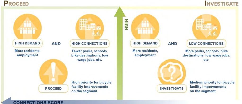
23 5. PRIORITIZATION SCORING AND METHODOLOGY A demand-connectivity matrix is a tool that can be utilized to prioritize segments for bicycle improvements. All segments were graphed on a matrix based on the demand score and the connectivity score with respect to gaps in the network. On the demand-connectivity matrix, demand relates to the potential demand for alternative modes along the roadway segment. As described in previous sections of this document, demand was calculated based on populations and employment within a ½ mile of the roadway segments. On the demand-connectivity matrix, connectivity relates to the score each segment received with respect to gaps in the network (parks, schools, transit routes with high ridership, etc.). The value range is defined from: Demand: Low (bottom half of graph): Segments with low population and low employment density. High (top half of graph): Segments with a high population and high employment density. Connectivity: High (left half of graph): Segments with a very high potential for bike ridership due to the high number of gaps in relation to features such as parks, schools, regional shopping, etc. Low (right half of graph): Segments with a lower potential for bike ridership due to the low number of gaps in relation to features such as parks, schools, regional shopping, etc. In general, the P-I-C-K rule of thumb should be considered when choosing bicycle network improvement projects to implement along roadway segments from a demand-connectivity matrix: P - Proceed: High Demand, High Connections (High priority segments) These segments are generally recommended for immediate or short term implementation because of the relatively high number of connections for bicyclists and the high demand along the segment for active transportation mode facilities. I-Investigate: High Demand, Low Connections (Medium priority segments) These segments are generally recommended as medium priority segments because of the relatively low number of connections for bicyclists and high demand along the segment for active transportation mode facilities. C - Consider: Low Demand, High Connections (Medium priority segments) These segments are generally recommended as medium priority segments because of the relatively high number of connections for bicyclists and low demand along the segment for active transportation mode facilities. K Keep for Consideration: Low Demand, Low Connections (Low priority segments) These segments are generally recommended as low priority segments because of the relatively low number of connections for bicyclists and low demand along the segment for active transportation mode facilities. Figure 6 illustrates the demand-connectivity matrix scoring theory. Page 16

24 Figure 6 Demand-Connectivity Matrix Scoring Theory Page 17
25 5.1. Demand-Connectivity Matrix Results As previously described, the demand score was based on population and employment density within ½ mile of the segments. The roadway connectivity score was based on assigning one point to each segment per gap type. The segments were then graphed on the demandconnectivity matrix, as shown in Figure 7. The segments were then color coded based on their quadrant location within the demandconnectivity matrix and graphically displayed on a map (Figure 8). Segments located within the P quadrant are high priority segments (high demand and potential for high connections), segments within the I and C quadrants are medium priority segments, and segments within the K quadrant are low priority segments (low demand and low connections). The size of the dots in the matrix on Figure 7 corresponds to the number of roadway segments. Page 18


26 Figure 7 Demand-Connectivity Matrix Number of Roadway Segments Page 19
27 DURANGO BUFFALO RAINBOW DECATUR DECATUR SIMMONS MARTIN L KING BERMUDA MARYLAND 5TH EASTERN LOSEE PECOS LAMB NELLIS RACETRACK VALLEY VIEW VALLE VERDE GREENWAY FRANK SINATRA PARADISE BRUCE CIVIC CENTER PECOS LAMB MOUNTAIN VISTA MARYLAND 147 Figure 8 Demand-Connectivity Map KYLE CANYON GRAND TETON ALIANTE ELKHORN JONES 2 2 CENTENNIAL CENTENNIAL TROPICAL ANN ALLEN CAMINO ELDORADO UP RR NELLIS SPUR ALEXANDER HUALAPAI LONE MOUNTAIN FORT APACHE RANCHO ALEXANDER CRAIG CHEYENNE ALEXANDER LAS VEGAS SMOKE RANCH CAREY CAREY LAKE MEAD LAKE MEAD FAR HILLS SUMMERLIN RAMPART CHARLESTON BUFFALO SUMMERLIN VEGAS UP RR OWENS FREMONT WASHINGTON BONANZA STEWART HOLLYWOOD 147 SAHARA TOWN CENTER DESERT INN HUALAPAI FLAMINGO SPRING MOUNTAIN FORT APACHE DURANGO RUSSELL TROPICANA VALLEY VIEW INDUSTRIAL PARADISE McCARRAN INTERNATIONAL AIRPORT WAYNE NEWTON RUSSELL LAMB DESERT INN BROADBENT BOULDER LAKE LAS VEGAS UP RR HEND SPUR JONES WARM SPRINGS SUNSET WARM SPRINGS WINDMILL BLUE DIAMOND PEBBLE WIGWAM ARROYO GRANDE RAMP W I2 N US LAKE MEAD WINDMILL WINDMILL WINDMILL STEPHANIE GIBSON PASEO VERDE BASIC MAJOR DEAN MARTIN SILVERADO RANCH MARYLAND ST ROSE SUNRIDGE HEIGHTS GREEN VALLEY HORIZON RIDGE HORIZON NEVADA STATE ANTHEM Downtown Las Vegas WASHINGTON RAMP N I N US RAMP S I US MLK BONANZA MARTIN L KING RAMP S US S I STEWART FREMONT UP RR UP RR LAS VEGAS Legend Existing Bike Lanes/Paths Bike Lane Demand-Connectivity Analysis Results High Priority UP RR CHARLESTON Shared Use Path Railroad Medium Priority Low Priority PARADISE SAHARA Page 20
28 6. HIGH PRIORITY RECOMMENDATIONS Based on the results of the demand-connectivity analysis, the map shown in Figure 8 was reviewed to determine high priority recommended locations for bicycle improvements. The recommended locations for high priority improvements were provided to the TWG and public for review and comment. Comments received from the public are provided in Appendix B and comments from the TWG are provided in Appendix C. Figure 9 shows the final project recommendations map based on the results of the demand-connectivity analysis and feedback from the TWG. The recommendations identify locations where bike improvements should be considered. In some cases recommended improvements were continued to a logical terminus. For purposes of this planning study, the bicycle improvements could include any one or combination of the following bike improvement alternatives (as defined in the RTC Complete Streets Design Guidelines for Livable Communities, March 2013): Addition of a bike lane: portions of the traveled way designated with striping, stencils, and signs for preferential use by bicyclists. Bike boulevard: street that has been modified to prioritize through bicycle traffic but discourage through motor vehicle traffic. Traffic calming devices control traffic speeds and discourage through trips by automobiles. Traffic controls limit conflicts between automobiles and bicyclists and give priority to through bicycle movement at intersections. Cycle track: specially designed bikeways separated from the parallel motor vehicle travel way by a line of parked cars, landscaping, or a physical buffer that motor vehicles cannot cross. Buffered bike lane: conventional bike lanes with a designated buffer space separating the bike lane from the adjacent motor vehicle lane. Transit/bike only lane: designated transit lanes that permit bikes. Transit vehicles have to change lanes to pass bicyclists. It is important to note that several corridors that received high demand and high connectivity scores are not shown on the project recommendations map. Based on feedback from the TWG, these corridors have been studied for the feasibility of bicycle improvements and it has been determined that based on existing constraints bicycle network improvements are not currently feasible. If possible, parallel or alternate routes should be considered in the future for these locations: Grand Central Parkway Alta Boulevard to City Parkway Las Vegas Boulevard Sahara Avenue to Stewart Avenue Charleston Boulevard Rampart Boulevard to Nellis Boulevard Lake Mead Boulevard Simmons Road to Anasazi Drive Valley View Boulevard Charleston Boulevard to Desert Inn Road Stewart Avenue Main Street to th Street Cheyenne Avenue within the City of North Las Vegas limits, from Decatur Boulevard to Civic Center Drive Decatur Boulevard Rancho Drive to the 2 Beltway Rancho Drive Washington Avenue to Vegas Drive Figure 9 provides a summary of the recommended bike improvement projects. These recommendations warrant further Page 21
29 consideration with respect to feasibility of construction. Bicycle improvements are recommended to comply with the most current edition of the MUTCD, AASHTO Guide for the Development of Bicycle Facilities, and/or the most current edition of the NACTO Urban Bikeway Design Guide. As new development and redevelopment occur, it is expected that adequate bike facilities will be requested and provided through the local jurisdiction s development process. In areas experiencing significant growth respect to demand, project prioritization may be modified or revisited to address the changes in the area. Also, the RTC is anticipated to partner with jurisdictions in increasing active transportation modes along. As the RTC moves forward with implementation of the project recommendations, the following items should be considered when evaluating corridors for bicycle improvements: Treatments on rights-of-way of 100 feet and greater should have an evaluation conducted to determine the best bicycle treatment for the facility. The study shall include, at a minimum, a look at vehicle mix, volumes, and speeds on the corridor. Investigate multiple treatment options, including conversion of a travel lane to a bike lane, bike boulevards, and/or a parallel roadway if right-of-way is constrained on the proposed roadway. Consider bicycle boulevards for low volume, low speed roadways where additional priorities for bicyclists can be provided. The recommendations made in this study will be included in in the update of the RTC s Bicycle and Pedestrian Plan, last updated in 2008, and scheduled for update in late In addition to local connectivity, it is important to provide regional connectivity. Regional routes assist with increasing bicycle commuting and bicycle tourism. Regional Routes were selected that connect across the Las Vegas Valley and provide connections for bicyclists coming into the Las Vegas Valley from surrounding communities. These routes will also satisfy the Nevada Revised Statute requirement for alternate routes for interstate roadways where bicycles are prohibited. Figure 10 provides proposed regional routes and Figure 11 illustrates the proposed regional routes with proposed route numbering that could be utilized on the alternate bicycle routes. Page 22
30 The proposed route numbering shown in Figure 11 has been created using the existing bicycle route numbering (such as 70) and new routes have been defined to match the corridors they are paralleling (2, 9, 160,, A and B). Other routes have been numbered using the typical interstate numbering of northsouth odd numbers and east-west even numbers. This numbering system can be revisited, as these routes are created in the future. Page 23
31 DURANGO BUFFALO RAINBOW DECATUR DECATUR SIMMONS MARTIN L KING BERMUDA MARYLAND 5TH EASTERN LOSEE PECOS LAMB NELLIS RACETRACK VALLEY VIEW VALLE VERDE GREENWAY FRANK SINATRA PARADISE BRUCE CIVIC CENTER PECOS MOUNTAIN VISTA MARYLAND 147 Figure 9 High Priority Recommendations Map KYLE CANYON GRAND TETON ALIANTE ELKHORN JONES 2 2 CENTENNIAL CENTENNIAL ANN ALLEN CAMINO ELDORADO TROPICAL UP RR NELLIS SPUR ALEXANDER HUALAPAI LONE MOUNTAIN FORT APACHE RANCHO ALEXANDER CRAIG CHEYENNE ALEXANDER LAS VEGAS SMOKE RANCH CAREY CAREY LAKE MEAD LAKE MEAD FAR HILLS SUMMERLIN RAMPART CHARLESTON BUFFALO SUMMERLIN VEGAS UP RR OWENS FREMONT WASHINGTON BONANZA STEWART HOLLYWOOD 147 SAHARA UP RR TOWN CENTER DESERT INN HUALAPAI FLAMINGO SPRING MOUNTAIN FORT APACHE RUSSELL DURANGO TROPICANA VALLEY VIEW INDUSTRIAL PARADISE McCARRAN INTERNATIONAL AIRPORT WAYNE NEWTON RUSSELL LAMB LAMB DESERT INN BROADBENT BOULDER LAKE LAS VEGAS UP RR HEND SPUR JONES WARM SPRINGS SUNSET WARM SPRINGS WINDMILL BLUE DIAMOND PEBBLE WIGWAM ARROYO GRANDE RAMP W I2 N US LAKE MEAD WINDMILL WINDMILL WINDMILL STEPHANIE GIBSON PASEO VERDE BASIC MAJOR DEAN MARTIN SILVERADO RANCH MARYLAND ST ROSE SUNRIDGE HEIGHTS GREEN VALLEY HORIZON RIDGE HORIZON NEVADA STATE ANTHEM Downtown Las Vegas WASHINGTON RAMP N I N US RAMP S I US MLK BONANZA Legend MARTIN L KING RAMP S US S I STEWART FREMONT Existing Bike Lanes/Paths Bike Lane Major Roadways Railroad UP RR LAS VEGAS CHARLESTON Shared Use Path High Priority Bike Facilities On-Street Bike Facility UP RR Shared Use Path PARADISE SAHARA Page 24

32 DURANGO BUFFALO RAINBOW DECATUR DECATUR SIMMONS MARTIN L KING BERMUDA MARYLAND 5TH EASTERN LOSEE PECOS LAMB NELLIS RACETRACK VALLEY VIEW VALLE VERDE GREENWAY FRANK SINATRA PARADISE BRUCE CIVIC CENTER PECOS MOUNTAIN VISTA MARYLAND 147 Figure 10 High Priority Recommendations Map with Regional Routes Highlighted KYLE CANYON GRAND TETON ALIANTE ELKHORN JONES 2 2 CENTENNIAL CENTENNIAL ANN ALLEN CAMINO ELDORADO TROPICAL UP RR NELLIS SPUR ALEXANDER HUALAPAI LONE MOUNTAIN FORT APACHE RANCHO ALEXANDER CRAIG CHEYENNE ALEXANDER LAS VEGAS SMOKE RANCH CAREY CAREY LAKE MEAD LAKE MEAD FAR HILLS SUMMERLIN RAMPART CHARLESTON BUFFALO SUMMERLIN VEGAS UP RR OWENS FREMONT WASHINGTON BONANZA STEWART HOLLYWOOD 147 SAHARA UP RR TOWN CENTER DESERT INN HUALAPAI FLAMINGO SPRING MOUNTAIN FORT APACHE RUSSELL DURANGO TROPICANA VALLEY VIEW INDUSTRIAL PARADISE McCARRAN INTERNATIONAL AIRPORT WAYNE NEWTON RUSSELL LAMB LAMB DESERT INN BROADBENT BOULDER LAKE LAS VEGAS UP RR HEND SPUR JONES WARM SPRINGS SUNSET WARM SPRINGS WINDMILL BLUE DIAMOND PEBBLE WIGWAM ARROYO GRANDE RAMP W I2 N US LAKE MEAD WINDMILL WINDMILL WINDMILL STEPHANIE GIBSON PASEO VERDE BASIC MAJOR DEAN MARTIN SILVERADO RANCH MARYLAND ST ROSE SUNRIDGE HEIGHTS GREEN VALLEY HORIZON RIDGE HORIZON NEVADA STATE ANTHEM Downtown Las Vegas WASHINGTON RAMP N I N US RAMP S I US MLK BONANZA Legend MARTIN L KING RAMP S US S I STEWART FREMONT Existing Bike Lanes/Paths Bike Lane Major Roadways Railroad UP RR LAS VEGAS Shared Use Path CHARLESTON High Priority Bike Facilities On-Street Bike Facility Shared Use Path UP RR Regional Routes PARADISE SAHARA Page 25

33 RAMPART DURANGO BUFFALO RAINBOW DECATUR DECATUR MARTIN L KING BERMUDA MARYLAND 5TH EASTERN LOSEE PECOS LAMB NELLIS RACETRACK VALLEY VIEW GREENWAY FRANK SINATRA PARADISE BRUCE CIVIC CENTER PECOS MOUNTAIN VISTA MARYLAND Figure 11 Proposed Regional Routes with Proposed Route Numbering KYLE CANYON GRAND TETON ««85 ELKHORN JONES 2 ANN RANCHO ALIANTE CENTENNIAL CAMINO ELDORADO CENTENNIAL 2 TROPICAL ALEXANDER HUALAPAI LONE MOUNTAIN FORT APACHE «B ALLEN ALEXANDER CRAIG CHEYENNE «ALEXANDER UP RR NELLIS SPUR LAS VEGAS «70 «2 SMOKE RANCH LAKE MEAD SIMMONS CAREY LAKE MEAD CAREY 147 FAR HILLS «9 SAHARA SUMMERLIN CHARLESTON BUFFALO SUMMERLIN «60 «B VEGAS UP RR UP RR OWENS FREMONT «30 WASHINGTON BONANZA STEWART HOLLYWOOD 147 TOWN CENTER DESERT INN HUALAPAI FLAMINGO SPRING MOUNTAIN FORT APACHE DURANGO RUSSELL TROPICANA VALLEY VIEW INDUSTRIAL PARADISE McCARRAN INTERNATIONAL AIRPORT WAYNE NEWTON «20 RUSSELL «70 LAMB LAMB DESERT INN «B «BROADBENT BOULDER LAKE LAS VEGAS «160 «5 «160 WINDMILL JONES WARM SPRINGS WINDMILL BLUE DIAMOND «5 DEAN MARTIN WINDMILL UP RR HEND SPUR PEBBLE SILVERADO RANCH «70 MARYLAND ST ROSE WIGWAM SUNRIDGE HEIGHTS ANTHEM GREEN VALLEY WINDMILL VALLE VERDE ARROYO GRANDE SUNSET WARM SPRINGS STEPHANIE GIBSON PASEO VERDE RAMP W I2 N US «105 HORIZON RIDGE BASIC LAKE MEAD MAJOR HORIZON «B «NEVADA STATE «70 «60 RAMP N I N US RAMP S I US MLK WASHINGTON BONANZA MARTIN L KING RAMP S US S I STEWART FREMONT Downtown Las Vegas Legend UP RR «B LAS VEGAS «XX Regional Routes Railroad Proposed Regional Route Name UP RR PARADISE «30 SAHARA CHARLESTON Page 26
34 APPENDIX A CONCEPTUAL COST ESTIMATES Appendix 27
35 COST ESTIMATES Conceptual cost estimates for generalized infrastructure improvement categories not specific individual improvements were developed. These estimates can be used for order-ofmagnitude comparisons between the identified priorities and do not include estimates for right-of-way or utility conflicts. Generalized cost estimates were created for the following scenarios: Concept 1: Conversion of outside travel lane to buffered bike lane Concept 2: Re-stripe six lane roadway with narrower lanes to accommodate a four foot bike lane Concept 3: Addition of six foot bike lane by relocating the sidewalk four feet Concept 4: Twelve foot hard surface shared use path Table A1 provides a summary of the conceptual cost estimates by concept. Detailed information is located in the following pages of this Appendix. Table A1 Conceptual Cost Estimates Concept Description Construction Cost per Mile 1 Conversion of outside travel lane to buffered bike lane 2 Re-stripe six lane roadway with narrower lanes to accommodate a four foot bike lane 3 Addition of six foot bike lane by relocating sidewalk four feet $21,000 $550,000 $1,200,000 4 Twelve foot hard surface shared use path $860,000 Does not include utilities or right-of-way. The Consultant has no control over the cost of labor, materials, equipment, or over the Contractor's methods of determining prices or over competitive bidding or market conditions. Opinions of probable costs provided herein are based on the information known to Consultant at this time and represent only the Consultant's judgment as a design professional familiar with the construction industry. The Consultant cannot and does not guarantee that proposals, bids, or actual construction costs will not vary from its opinions of probable costs. Appendix 28
36 APPENDIX B PUBLIC INPUT Appendix 29
37 PUBLIC INPUT Prior to the public meeting, the Draft Regional Bicycle Network Gap Analysis Report along with the RTC s Draft Bike Map Update were distributed to the RTC Bike Ride List, which contains 171 individuals, and is a distribution list used by the RTC for general distribution of bicycle related items such as RTC sponsored rides, bike maintenance, bicycle trainings, etc. In the , individuals were asked to attend the public meeting and/or provide written feedback on the Draft Regional Bicycle Network Gap Analysis Report along with the RTC s Draft Bike Map Update. Four individuals responded to the from the RTC. Additionally the information from the was placed on the Biking Las Vegas Website, and multiple individuals posted their comments online. The public meeting was held at the RTC in Conference Room 108, from 4:30 PM to 6:30 PM on Thursday, March 27, The purpose of the meeting was to solicit comments on the Regional Bicycle Network Gap Analysis as well as the RTC Draft Bike Map Update. Visual representations of the project data generated during the data development/preliminary analysis were displayed and a series of maps were provided with the results of the analysis. Thirteen individuals attended the public meeting. Written comments from the public meeting and comments received in response to the blast were incorporated into the project recommendations, as appropriate. Table B1 includes all of the public meeting and ed comments as well as responses to the comments. Appendix 30
38 Table B1 Summary of Public Review Comments on Draft Report No. Source/Date Public Review Comment Consultant Response/Comment 1 Michael Gorum/ Kristina Swallow/ Paul Johnson/ Chris Race/ Having paths to safely Commute from Downtown Las Vegas to the strip area via Maryland Pkwy or Paradise Rd. Need bike facilities on Charleston and Grand Central Pkwy. Shared lane marking on Grand Central Pkwy. Add bike lane on Charleston. Need to add bike lane on Oakey, East of Rainbow. Please consider marking the Vegas Valley Rim Trail on your maps and especially your existing and proposed bike facilities maps. My name is Chris Race and I'm a resident living in Southern Highlands. I recently read the RTC Bicycle Network Gap Analysis and loved to see such a study conducted about bike transportation and safety. A bike lane is recommended on Maryland Parkway from downtown to Russell Road. Bike lanes are also located on Tropicana Avenue and Flamingo Road to connect Maryland Parkway to the Strip. Bike lanes are lanes are recommended on Las Vegas Boulevard (The Strip) as well. At the request of the City of Las Vegas immediate bike lane recommendations have been removed from Charleston Avenue. The RTC and TWG could consider adding this corridor in the update of the RTC s Bicycle and Pedestrian Plan, which is scheduled for an update in late Bike lanes are included from Charleston to Bonneville. Bike lanes are being added on Oakey at the end of this year by the City of Las Vegas from Torrey Pines to Industrial. It is recommended that the Vegas Valley Rim Trail be shown in the update to the RTC s Bicycle and Pedestrian Plan, which is scheduled for an update in late So noted. Appendix 31
Amendment to the Summary of Regional Strategic Investments included in the Regional Transportation Plan
 Attachment A Amendment to the Summary of Regional Strategic Investments included in the Regional Transportation Plan Street and Highway improvements Project costs include all funded phases including planning,
ADOT Statewide Bicycle and Pedestrian Program Summary of Phase IV Activities APPENDIX B PEDESTRIAN DEMAND INDEX
 ADOT Statewide Bicycle and Pedestrian Program Summary of Activities APPENDIX B PEDESTRIAN DEMAND INDEX May 24, 2009 Pedestrian Demand Index for State Highway Facilities Revised: May 29, 2007 Introduction
APPENDIX G: 20 Year Transportation Improvement Project Cost Lists
 APPENDIX G: 20 Year Transportation Improvement Project Cost Lists Fiscal Year 2018 2022 Projects KEY BIKE LANE QUANTITY FOR KPI LENGTH ESTIMATED CLV OTHER ENTITY Buffered Non Buffered but New Basic WARD
NM-POLICY 1: Improve service levels, participation, and options for non-motorized transportation modes throughout the County.
 Transportation PRINCE WILLIAM COUNTY 2008 COMPREHENSIVE PLAN NON-MOTORIZED PLAN CONTENTS Goals, Policies, and Action Strategies Table 4 (Bike Facility Classifications and Descriptions) Table 5 (Bike Facility
TABLE OF CONTENTS. Executive Summary
 Executive Summary Background... ES-1 Pedestrian Network... ES-2 Bikeway Network... ES-2 Collision History... ES-2 Public Input... ES-4 Conclusions and Recommendations... ES-4 1. Introduction and Setting
AVAILABLE: Park West Business Center
 VALLEY VIEW BLVD. INTERSTATE 15 PECOS AVAILABLE: Park West Business Center 6365 Montessouri Street Las Vegas, Nevada 89113 ±46,020 SF Free-Standing Industrial Building Property Features ±46,020 SF Available;
APPENDIX A: Complete Streets Checklist DRAFT NOVEMBER 2016
 APPENDIX A: Complete Streets Checklist DRAFT NOVEMBER 2016 Complete Streets Checklist MetroPlan Orlando s Complete Streets Checklist is an internal planning tool for staff to further implementation of
Solana Beach Comprehensive Active Transportation Strategy (CATS)
") Solana Beach Comprehensive Active Transportation Strategy (CATS) 3.0 Goals & Policies The Solana Beach CATS goals and objectives outlined below were largely drawn from the Solana Beach Circulation Element
Solana Beach Comprehensive Active Transportation Strategy (CATS) 3.0 Goals & Policies The Solana Beach CATS goals and objectives outlined below were largely drawn from the Solana Beach Circulation Element
Highway 111 Corridor Study
 Highway 111 Corridor Study June, 2009 LINCOLN CO. HWY 111 CORRIDOR STUDY Draft Study Tea, South Dakota Prepared for City of Tea Sioux Falls Metropolitan Planning Organization Prepared by HDR Engineering,
Route 7 Corridor Study
 Route 7 Corridor Study Executive Summary Study Area The following report analyzes a segment of the Virginia State Route 7 corridor. The corridor study area, spanning over 5 miles in length, is a multi
Pedestrian Project List and Prioritization
 To: Kyle Wagenschutz, City of Memphis CC: From: Anne Conlon and John Cock, Alta Planning + Design Date: December, 2014 Re: Project List Development (Task 3.1-3.2) and Project List Prioritization (Task
Connecting cyclists to work. Syracuse Metropolitan Transportation Council
 Connecting cyclists to work Syracuse Metropolitan Transportation Council Overview Prepared at request: NYS Department of Transportation (NYSDOT) Project Achievements Target group Purpose Process Recommendations
PATRICK COMMERCE CENTER
 S PECOS ROAD PATRICK COMMERCE CENTER KYLE CANYON GATEWAY SPRING MOUNTAIN SILVERSTONE IRON MOUNTAIN PARK HIGHLANDS PROVIDENCE ELKHORN SPRINGS ALIANTE EL DORADO LAS VEGA MOTOR SPEE PAINTED DESERT LOS PRADOS
AGENDA ITEM G-2 Public Works
 AGENDA ITEM G-2 Public Works STAFF REPORT City Council Meeting Date: 12/6/2016 Staff Report Number: 16-214-CC Regular Business: Approve the Oak Grove University Crane Bike Improvement Concept Plan, authorize
12 RECOMMENDATIONS Road Improvements. Short Term (generally the next five years)
") 12 RECOMMENDATIONS Recommendations are based on the technical analysis of existing and future road and active transportation conditions, the results of the review of existing City policies and public feedback.
12 RECOMMENDATIONS Recommendations are based on the technical analysis of existing and future road and active transportation conditions, the results of the review of existing City policies and public feedback.
TOWN OF PORTLAND, CONNECTICUT COMPLETE STREETS POLICY
 TOWN OF PORTLAND, CONNECTICUT COMPLETE STREETS POLICY I. VISION, GOALS & PRINCIPLES VISION To improve the streets of Portland making them safer and more accessible for all users including pedestrians,
MASTER BICYCLE AND PEDESTRIAN PLAN
 VILLAGE OF NORTHBROOK MASTER BICYCLE AND PEDESTRIAN PLAN DRAFT PLAN OPEN HOUSE May 2, 2018 AGENDA 1. Community Engagement 2. Vision and Goals 3. General Structure of Plan 4. Recommendations Overview 5.
Exhibit 1 PLANNING COMMISSION AGENDA ITEM
 Exhibit 1 PLANNING COMMISSION AGENDA ITEM Project Name: Grand Junction Circulation Plan Grand Junction Complete Streets Policy Applicant: City of Grand Junction Representative: David Thornton Address:
TRAFFIC STUDY GUIDELINES Clarksville Street Department
 TRAFFIC STUDY GUIDELINES Clarksville Street Department 9/1/2009 Introduction Traffic studies are used to help the city determine potential impacts to the operation of the surrounding roadway network. Two
4. ENVIRONMENTAL IMPACT ANALYSIS 9. TRANSPORTATION AND TRAFFIC
 4. ENVIRONMENTAL IMPACT ANALYSIS 9. TRANSPORTATION AND TRAFFIC 4.9.1 INTRODUCTION The following section addresses the Proposed Project s impact on transportation and traffic based on the Traffic Study
City of Charlottesville Bicycle and Pedestrian Master Plan Update
 City of Charlottesville Bicycle and Pedestrian Master Plan Update September 17, 2014 I. Welcome and meeting overview II. Project status update III. Network overview IV. Break-out groups Pedestrian Network
CITY OF COCOA BEACH 2025 COMPREHENSIVE PLAN. Section VIII Mobility Element Goals, Objectives, and Policies
 CITY OF COCOA BEACH 2025 COMPREHENSIVE PLAN Section VIII Mobility Element Goals, Objectives, and Policies Adopted August 6, 2015 by Ordinance No. 1591 VIII MOBILITY ELEMENT Table of Contents Page Number
Hennepin County Pedestrian Plan Public Comment Report
 Hennepin County Pedestrian Plan Public Comment Report On May 31, 2013, the draft Hennepin County Pedestrian Plan was released for a 45-day public comment period ending July 15, 2013. The county received
REGIONAL BICYCLE AND PEDESTRIAN DESIGN GUIDELINES
 REGIONAL BICYCLE AND PEDESTRIAN DESIGN GUIDELINES November 16, 2011 Deb Humphreys North Central Texas Council of Governments Bicycle and Pedestrian Advisory Committee Snapshot of the Guide 1. Introduction
WELCOME. Thank you for joining us at the Second Public Workshop for the Carlsbad Pedestrian Master Plan. We look forward to receiving your feedback.
 City of Carlsbad Pedestrian Master Plan: WELCOME WELCOME Please Sign In Provide Input at Flip Charts Review Boards Presentation of Draft Plan Thank you for joining us at the Second Public Workshop for
A METHODOLOGY TO IDENTIFY HIGH PEDESTRIAN CRASH LOCATIONS: AN ILLUSTRATION USING THE LAS VEGAS METRO AREA
 A METHODOLOGY TO IDENTIFY HIGH PEDESTRIAN CRASH LOCATIONS: AN ILLUSTRATION USING THE LAS VEGAS METRO AREA Srinivas S. Pulugurtha Transportation Research Center University of Nevada, Las Vegas 4505 Maryland
2010 Pedestrian and Bicyclist Special Districts Study Update
 2010 Pedestrian and Bicyclist Special Districts Study Update Pedestrian and Bicyclist Special Districts Program Overview H-GAC s Special Districts Program aims to provide strategic investments in pedestrian
Tulsa Metropolitan Area LONG RANGE TRANSPORTATION PLAN
 Tulsa Metropolitan Area LONG RANGE TRANSPORTATION PLAN Indian Nations Council of Governments August 2005 CONTACTING INCOG In developing the Destination 2030 Long Range Transportation Plan, INCOG s Transportation
MnDOT Implementation of Complete Streets Policy. January 2014
 MnDOT Implementation of Complete Streets Policy January 2014 1 Prepared by Minnesota Department of Transportation 395 John Ireland Boulevard Saint Paul, Minnesota 55155-1899 Phone: 651-296-3000 Toll-Free:
South King County High-Capacity Transit Corridor Study
 HIGH-CAPACITY TRANSIT CORRIDOR STUDY South King County Corridor South King County High-Capacity Transit Corridor Study Corridor Report August 2014 South King County High Capacity Transit Corridor Report
RESOLUTION NO ?? A RESOLUTION OF THE CITY OF NEPTUNE BEACH ADOPTING A COMPLETE STREETS POLICY
 RESOLUTION NO. 2018-?? A RESOLUTION OF THE CITY OF NEPTUNE BEACH ADOPTING A COMPLETE STREETS POLICY WHEREAS, safe, convenient, and accessible transportation for all users is a priority of the City of Neptune
GIS Based Non-Motorized Transportation Planning APA Ohio Statewide Planning Conference. GIS Assisted Non-Motorized Transportation Planning
 The Purpose of GIS Assisted Network GIS Assisted Non-Motorized Transportation 2011 APA Ohio Statewide Conference Friday, 10:45 AM to Noon Focus on near-term projects wwwgreenwaycollabcom The purpose of
Bicycle Master Plan Goals, Strategies, and Policies
 Bicycle Master Plan Goals, Strategies, and Policies Mobilizing 5 This chapter outlines the overarching goals, action statements, and action items Long Beach will take in order to achieve its vision of
Chapter 14 PARLIER RELATIONSHIP TO CITY PLANS AND POLICIES. Recommendations to Improve Pedestrian Safety in the City of Parlier (2014)
") Chapter 14 PARLIER This chapter describes the current status and future plans for biking and walking in the City of Parlier. RELATIONSHIP TO CITY PLANS AND POLICIES The Parlier General Plan is the primary
Chapter 14 PARLIER This chapter describes the current status and future plans for biking and walking in the City of Parlier. RELATIONSHIP TO CITY PLANS AND POLICIES The Parlier General Plan is the primary
3.0 Future Conditions
 3.0 Future Conditions In order to be able to recommend appropriate improvements to the transportation system of the Town, it is important to first understand the nature and volume of traffic that is expected
TRAFFIC IMPACT STUDY CRITERIA
 Chapter 6 - TRAFFIC IMPACT STUDY CRITERIA 6.1 GENERAL PROVISIONS 6.1.1. Purpose: The purpose of this document is to outline a standard format for preparing a traffic impact study in the City of Steamboat
Corpus Christi Metropolitan Transportation Plan Fiscal Year Introduction:
 Introduction: The Safe, Accountable, Flexible, Efficient Transportation Equity Act: A Legacy for Users (SAFETEA-LU) has continued the efforts started through the Intermodal Surface Transportation Efficiency
City of Memphis On-Street Parking Modification Guidelines
 City of Memphis Effective Date: December 1, 2013 Bicycle/Pedestrian Program 125 N. Main Street Memphis, TN 38103 (901) 576-6710 www.bikepedmemphis.com City of Memphis Executive Summary It is current practice
Scope of Services BICYCLE/PEDESTRIAN PLAN FOR THE INDIAN RIVER COUNTY MPO
 I. INTRODUCTION Scope of Services BICYCLE/PEDESTRIAN PLAN FOR THE INDIAN RIVER COUNTY MPO The Indian River County Metropolitan Planning Organization (MPO) Bicycle and Pedestrian Plan was completed in 1997.
City of Homewood Transportation Plan
 City of Homewood Transportation Plan Prepared for: City of Homewood, Alabama Prepared by: Skipper Consulting, Inc. May 2007 TABLE OF CONTENTS INTRODUCTION... 1 BACKGROUND INFORMATION... 1 EXISTING TRANSPORTATION
Perryville TOD and Greenway Plan
 Perryville TOD and Greenway Plan Greenway Glossary Pathway: A bicycle and pedestrian path separated from motorized vehicular traffic by an open space, barrier or curb. Multi-use paths may be within the
Proposed Bridge Street East Bicycle Lanes Public Open House Thursday, April 27, 2017
 WELCOME Proposed Bridge Street East Bicycle Lanes Public Open House Thursday, April 27, 2017 Purpose of the Open House The purpose of this Open House is to gain public input on the bicycle lanes proposed
Agenda. Overview PRINCE GEORGE S PLAZA METRO AREA PEDESTRIAN PLAN
 PRINCE GEORGE S PLAZA METRO AREA PEDESTRIAN PLAN May 28, 2008 Agenda Welcome and introductions Project overview and issue identification Planning context and strengths Design challenges and initial recommendations
Proposed. City of Grand Junction Complete Streets Policy. Exhibit 10
 Proposed City of Grand Junction Complete Streets Policy Exhibit 10 1 City of Grand Junction Complete Streets Policy Vision: The Complete Streets Vision is to develop a safe, efficient, and reliable travel
Planning Guidance in the 2012 AASHTO Bike Guide
 Planning Guidance in the 2012 AASHTO Bike Guide Presentation by: RJ Eldridge Peter Lagerwey August 22, 2012 WEBINAR 2: PLANNING GUIDANCE IN THE 2012 AASHTO BIKE GUIDE Today s Webinar Significant Updates
TRAFFIC ACTION PLAN. North Central Neighborhood CITY OF SAN MATEO
 TRAFFIC ACTION PLAN North Central Neighborhood CITY OF SAN MATEO Draft February 2017 Table of Contents Introduction... 1 The Traffic Forum Process... 4 Neighborhood Traffic Issues... 6 Neighborhood Recommendations
APPENDIX B: Planned and Programmed Improvements Technical Memorandum
 APPENDIX B: Planned and Programmed Improvements Technical Memorandum MOBILITY MASTER PLAN Planned and Programmed Improvements Technical Memorandum Prepared for April 2015 Contents Acronyms and Abbreviations...
NJDOT Complete Streets Checklist
 Background The New Jersey Department of Transportation s Complete Streets Policy promotes a comprehensive, integrated, connected multi-modal network by providing connections to bicycling and walking trip
Goodlettsville Bicycle and Pedestrian Plan Executive Summary
 Goodlettsville Bicycle and Pedestrian Plan July 2010 In Cooperation with the Nashville Area Metropolitan Planning Executive Organization Summary Introduction Progressive and forward thinking communities
2018 Pedestrian and Bicycle and Safe Routes to School Application for Funding Page 1 of 31
 2018 Pedestrian and Bicycle and Safe Routes to School Application for Funding Page 1 of 31 2018 Pedestrian and Bicycle and Safe Routes to School Application for Funding Part 1: General Information Funding
PROJECT BACKGROUND/DESCRIPTION
 SCOPE OF SERVICES St. Charles Parish Comprehensive Pedestrian and Bicycle Master Plan (CPBP) St. Charles Parish, Louisiana State Project No. H. 012462 RPC Project No. SCPBMP1 PROJECT BACKGROUND/DESCRIPTION
Rail Station Fact Sheet DFW Airport North Station* (*station under construction with anticipated start of service in late 2018)
") Rail Station Fact Sheet DFW Airport North Station* (*station under construction with anticipated start of service in late 018) Station Overview DFW Airport North Station will be located on DFW nternational
Rail Station Fact Sheet DFW Airport North Station* (*station under construction with anticipated start of service in late 018) Station Overview DFW Airport North Station will be located on DFW nternational
General Plan Circulation Element Update Scoping Meeting April 16, 2014 Santa Ana Senior Center, 424 W. 3rd Street, Santa Ana, CA 92701
 General Plan Circulation Element Update Scoping Meeting April 16, 2014 Santa Ana Senior Center, 424 W. 3rd Street, Santa Ana, CA 92701 Meeting Agenda 1. Purpose of Scoping Meeting 2. Project Overview 3.
City Snapshot September 27, 2018
 1 City Snapshot September 27, 2018 Respondent Introduction Thank you for providing data for the PlacesForBikes City Rating program! The information you provide will be used to understand the progress your
AMENDING MOTION: Mobility Plan - Pedestrians and Disadvantaged Communities
 I MOVE that the Council: AMENDING MOTION: Mobility Plan - Pedestrians and Disadvantaged Communities 1. INSTRUCT the Department of City Planning to amend the proposed Mobility Plan to include the following;
PRINCE GEORGE S PLAZA METRO AREA PEDESTRIAN PLAN
 PRINCE GEORGE S PLAZA METRO AREA PEDESTRIAN PLAN May 28, 2008 Agenda Welcome and introductions Project overview and issue identification Planning context and strengths Design challenges and initial recommendations
Goals, Objectives, and Policies
 Goals, Objectives, and Policies ADVISORY GROUP INPUT PUBLIC INPUT SNS PREVIOUS STUDIES RBPP Goals Vision Statement Southern Nevada will develop a safe, connected, and convenient walking and bicycling system
ADA Transition Plan. City of Gainesville FY19-FY28. Date: November 5, Prepared by: City Of Gainesville Department of Mobility
 ADA Transition Plan FY19-FY28 Date: November 5, 2018 Prepared by: City Of Gainesville Department of Mobility 1.0 INTRODUCTION 1.1 BACKGROUND The federal statute known as the Americans with Disabilities
Traffic Impact Study. Westlake Elementary School Westlake, Ohio. TMS Engineers, Inc. June 5, 2017
 TMS Engineers, Inc. Traffic Impact Study Westlake Elementary School Westlake, Ohio June 5, 2017 Prepared for: Westlake City Schools - Board of Education 27200 Hilliard Boulevard Westlake, OH 44145 TRAFFIC
Chapter 5 Future Transportation
 Chapter 5 Future Transportation The Future Land Use Plan identifies the desired land use designations. The land uses desired for Crozet depend, in large part, on the success of the transportation system,
Goal 3: Foster an environment of partnerships and collaboration to connect our communities and regions to one another.
 Non-Motorized Transportation Plan (NMTP) Draft Vision, Goal and,, Tri-County Regional Planning Commission (TCRPC) Purpose The purpose of the Tri-County Regional Planning Commission (TCRPC) Non-Motorized
University of Victoria Campus Cycling Plan Terms of Reference. 1.0 Project Description
 University of Victoria Campus Cycling Plan Terms of Reference 1.0 Project Description The Campus Cycling Plan, a first for the University, will provide a comprehensive and coordinated approach to support
NOTICE OF AVAILABILITY/NOTICE OF COMMENT PERIOD OF A DRAFT EIR/EIS/EIS FOR PUBLIC REVIEW AND HEARINGS
 Tahoe Transportation District 128 Market Street, Suite 3F Stateline, NV 89449 Phone: (775) 589-5500 www.tahoetransportation.org Federal Highway Administration 650 Capitol Mall, Suite 4-100 Sacramento,
Madison Urban Area and Dane County. Bicycle Transportation Plan Summary. September Introduction. Bicycle Plan Scope and Planning Process
 Bicycle Transportation Plan Summary Madison Urban Area and Dane County Introduction September 2000 Bicycling is an important mode of transportation in the Madison urban area and countywide that is available
Circulation in Elk Grove includes: Motor vehicles, including cars and trucks
 Circulation, as it is used in this General Plan, refers to the many ways people and goods move from place to place in Elk Grove and the region. Circulation in Elk Grove includes: Motor vehicles, including
Relevant Studies and Industry Practices Summary
 April 1, 2016 Draft Prepared For: Prepared By: Background There are a number of residential areas in unincorporated Clark County (County) that have an Overlay District and Planned Land use designation
Living Streets Policy
 Living Streets Policy Introduction Living streets balance the needs of motorists, bicyclists, pedestrians and transit riders in ways that promote safety and convenience, enhance community identity, create
Non-Motorized Transportation 7-1
 Non-Motorized Transportation 7-1 Transportation facilities no longer mean just accommodating a vehicle powered by a combustion engine. Pedestrian and non-motorized facilities are important modes of travel
6.0 PEDESTRIAN AND BICYCLE FACILITIES 6.1 INTRODUCTION 6.2 BICYCLE DEMAND AND SUITABILITY Bicycle Demand
 6.0 PEDESTRIAN AND BICYCLE FACILITIES 6.1 INTRODUCTION Bicycle and pedestrian travel along and in the vicinity of the corridor is part of the vision of Somerset and Hunterdon counties and the integrated
ADA TRANSITION PLAN 2013
 ADA TRANSITION PLAN 2013 TABLE OF CONTENTS Contents Introduction 1 Purpose 2 Identified Obstacles to the Public Right of Way 3 Criteria for Determining Impediments at Village Facilities 4 Removing Barriers
5.0 Roadway System Plan
 Southwest Boise Transportation Study Page 16 5.0 Roadway System Plan The Roadway System Plan outlines roadway improvements in the Initial Study Area. It forecasts future deficiencies on the arterial system,
David DiPierro, John Amberson. Steering Committee Meeting #4 Overview
 IBI GROUP 18401 Von Karman Avenue Suite 110 Irvine CA 92612 USA tel 949 833 5588 fax 949 833 5511 ibigroup.com Memorandum To/Attention Steering Committee Members Date February 17, 2016 From IBI Group Project
2014/2015 BIKE ROUTE PLAN 83 AVENUE PROTECTED BIKE LANE
 About the Project 2014/2015 BIKE ROUTE PLAN The City of Edmonton is planning a major bike route on the south side of Edmonton. This bike route is one part of a plan to provide citizens with transportation
TRANSPORTATION & MOBILITY
 TRANSPORTATION & MOBILITY ROADWAY SYSTEM There are approximately 40 miles of roadways in Manitou Springs. For planning purposes, roadways are typically assigned a functional classification which defines
Executive Summary Route 30 Corridor Master Plan
 Route Corridor Master Plan Project Overview The Route Corridor Master Plan is a coordinated multimodal transportation and land use plan for the entire stretch of Route through East Whiteland Township,
TRANSPORTATION COMMISSION Agenda Staff Report
 TRANSPORTATION COMMISSION Agenda Staff Report Agenda Item No. 5.a DATE: JULY 31, 2014 TO: FROM: SUBJECT: TRANSPORTATION COMMISSION COMMUNITY DEVELOPMENT DEPARTMENT - PLANNING DRAFT OLYMPIC CORRIDOR PREFERRED
Chapter 13 ORANGE COVE
 Chapter 13 ORANGE COVE This chapter describes the current status and future plans for biking and walking in the City of Orange Cove. RELATIONSHIP TO CITY PLANS AND POLICIES The Orange Cove General Plan
Chapter 7. Transportation. Transportation Road Network Plan Transit Cyclists Pedestrians Multi-Use and Equestrian Trails
 Chapter 7 Transportation Transportation Road Network Plan Transit Cyclists Pedestrians Multi-Use and Equestrian Trails 7.1 TRANSPORTATION BACKGROUND The District of Maple Ridge faces a number of unique
Appendix B: Forecasting and Traffic Operations Analysis Framework Document
 Existing Conditions Report - Appendix Appendix B: Forecasting and Traffic Operations Analysis Framework Document This document defines the methodology and assumptions that will be used in the traffic forecasting
WALKNBIKE DRAFT PLAN NASHVILLE, TENNESSEE EXECUTIVE SUMMARY NASHVILLE, TENNESSEE
 NASHVILLE, TENNESSEE EXECUTIVE SUMMARY Executive Summary A world-class multi-modal transportation system is essential to a vibrant city and better quality of life. -Mayor Barry The WalknBike plan aims
Bicycle and Pedestrian
 Bicycle and Pedestrian Planning for Bikeable and Walkable Communities W H O L E H E A L T H C O N F E R E N C E 0 3 / 2 2 / 2 0 1 6 R O Y G O T H I E P E N N D O T B I C Y C L E - P E D E S T R I A N C
PEDESTRIAN ACTION PLAN
 ATTACHMENT 2 CITY OF SANTA MONICA PEDESTRIAN ACTION PLAN CITY OF SANTA MONICA PEDESTRIAN ACTION PLAN This page intentionally left blank EXECUTIVE SUMMARY CHAPTER 1 EXECUTIVE SUMMARY Setting the Stage
Final Sidewalk Feasibility Study
 Garfield Drive From Anastasia Drive to Elizabeth Place City of South Daytona July 23, 2009 Final Sidewalk Feasibility Study Prepared for: Prepared by: Final Sidewalk Feasibility Study Garfield Drive 2
MONTGOMERY COUNTY PLANNING DEPARTMENT THE MARYLAND-NATIONAL CAPITAL PARK AND PLANNING COMMISSION
 MONTGOMERY COUNTY PLANNING DEPARTMENT THE MARYLAND-NATIONAL CAPITAL PARK AND PLANNING COMMISSION MCPB Item No. 4 Date: 09-10-15 Scope of Work for the Bicycle Master Plan David Anspacher, Planner/Coordinator,
SECTION 1 - TRAFFIC PLANNING
 SECTION 1 - TRAFFIC PLANNING 1.1 TRAFFIC OPERATIONS 1.1.1 Roadway Functional Classification The Multnomah County Comprehensive Framework Plan s Policy 34: Trafficways and the Functional Classification
East Burke Transportation, Safety and Capacity Improvements
 East Burke Transportation, Safety and Capacity Improvements The purpose of this project is to increase mobility and improve safety for pedestrians, cyclists, and motor vehicles along VT Route 114 in the
RZC Appendix 8A Marymoor Subarea Street Requirements
 RZC Appendix 8A Marymoor Subarea Street Requirements For additional design details for Marymoor Subarea infrastructure, refer to the 2017 Marymoor Subarea Infrastructure Planning Report. STREET REQUIREMENTS
MAG Town of Cave Creek Bike Study Task 6 Executive Summary and Regional Significance Report
 Page 1 MAG Town of Cave Creek Bike Study Task 6 Executive Summary and Regional Significance Report August 1, 2012 MAG Project #481 Page 2 Task 6 Executive Summary and Regional Significance Report Introduction
Off-road Trails. Guidance
 Off-road Trails Off-road trails are shared use paths located on an independent alignment that provide two-way travel for people walking, bicycling, and other non-motorized users. Trails specifically along
ACTIVE TRANSPORTATION
 ACTIVE TRANSPORTATION Mobility 2040 Supported Goals Improve the availability of transportation options for people and goods. Support travel efficiency measures and system enhancements targeted at congestion
Preliminary Transportation Analysis
 Preliminary Transportation Analysis Goals of a Robust, Multimodal Transportation Network Safe Accessible/Connected Efficient Comfortable Context-Sensitive Motor Vehicle: Continue to analyze the data to
Bridge Street Corridor Study Report
 Bridge Street Corridor Study Report Prepared for: Prepared by: BRIDGE STREET CORRIDOR STUDY REPORT PREPARED FOR: CITY OF ARROYO GRANDE COMMUNITY DEVELOPMENT DEPARTMENT 300 EAST BRANCH STREET ARROYO GRANDE,
Bicycle Friendly Niagara Falls
 Bicycle Friendly Niagara Falls STAKEHOLDER COMMITTEE MEETING 2 SUPPORTED BY THE OATH COMMUNITY FUND AT THE COMMUNITY FOUNDATION FOR GREATER BUFFALO Develop a Bicycle Master Plan to document the city s
ARLINGTON COUNTY, VIRGINIA
 ARLINGTON COUNTY, VIRGINIA County Board Agenda Item Meeting of October 15, 2016 DATE: October 7, 2016 SUBJECT: Adoption of amendments to the Master Transportation Plan (MTP) to create a new Pedestrian
GIS Based Data Collection / Network Planning On a City Scale. Healthy Communities Active Transportation Workshop, Cleveland, Ohio May 10, 2011
 The Purpose of GIS Based Network Planning GIS Based Data Collection / Network Planning Healthy Communities Active Transportation Conference Tuesday, May 10, 2011 10:00 AM Norman Cox, LLA, ASLA. Ann Arbor,
PRESS RELEASE San Joaquin Council of Governments
 PRESS RELEASE San Joaquin Council of Governments For Immediate Release February 23, 2018 Contact: Nicole Gorham, 235-0582 gorham@sjcog.org SJCOG Board Awards $19.63 Million in Measure K Bicycle, Pedestrian,
1.0 INTRODUCTION 1.1 PURPOSE OF THIS REPORT
 1.0 INTRODUCTION This chapter provides an overview of the purpose, authorization and focus of this Recirculated Draft Environmental Impact Report (EIR), an identification of the Lead Agency, an outline
Rail Station Fact Sheet CentrePort/DFW Airport Station
 Rail Station Fact Sheet CentrePort/DFW Airport Station Station Overview CentrePort/DFW Airport Station is located by Statler Boulevard at Breezewood Drive in Fort Worth. Free shuttles connect the station
BETHEL ROAD AND SEDGWICK ROAD CORRIDOR STUDY
 DRAFT PLAN City Council Meeting August 14, 2017 STUDY AREA Sedgwick Corridor State Route 160, principal arterial with Class 3 access management designation, commuter and freight route, connection to SR
Proposed White Flint Separated Bike Lane Network September 2015
 Proposed White Flint Separated Bike Lane Network September 2015 Abstract This report includes a proposed separated bike lane network for the White Flint Sector Plan area. Separated bike lanes create a