BIG COTTONWOOD CANYON 3T MANAGEMENT PROJECT
|
|
|
- Aldous Colin Sullivan
- 6 years ago
- Views:
Transcription

1 2017 BIG COTTONWOOD CANYON 3T MANAGEMENT PROJECT Managing Traffic, Trails, and Toilets Alternatives Study Prepared for the Big Cottonwood Community Council March 2017 CVEEN [Spring 2017] Department of Civil and Environmental Engineering The University of Utah
2 PROJECT TEAM LETTER Dear Big Cottonwood Community Council: The CVEEN 4910 Senior Design Class of Spring 2017 at the University of Utah is pleased to present the feasibility study component of the Big Cottonwood Canyon 3T Management Project (BCC3T). The team has considered many solutions to improve safety and access while preserving the beauty of the canyon. These solutions were selected based on their potential to be both sustainable and aesthetically pleasing while addressing principle needs presented by the Big Cottonwood Community Council. A major factor in our definition of sustainability is that the project be financially self-supporting. Although estimated costs and budgets may present significant constraints to implementation in Big Cottonwood Canyon, the overall intention of the BCC3T is to present both immediately attainable solutions as well as a possible long-term vision. In order to promote creativity and innovation, potential political or legal constraints were not addressed in this phase of the project. Due to the time limits imposed by the University of Utah semester schedule, this feasibility analysis cannot be as complete or in-depth as the complex situation of Big Cottonwood Canyon warrants. While the focus of the class must be solutions that can be achieved through the lens of Civil Engineering, the Senior Design team hopes that this report can be useful in future planning discussions and community organization efforts for the diverse group of canyon stakeholders. Our team looks forward to presenting these solutions and receiving your vision and feedback while moving forward with a preliminary engineering report. Sincerely, CVEEN 4910 Senior Design Class of Spring
3 EXECUTIVE SUMMARY Big Cottonwood Canyon is a highly desired location for recreation and retreat in Salt Lake City. Overuse of the canyon has created safety, sanitation, and congestion concerns that must be immediately addressed. The purpose of this report is to propose feasible and sustainable solutions for the present needs in Big Cottonwood Canyon. The solutions found in this report are presented as models that are differentiated by the amount of impact the canyon would experience during implementation. Low impact solutions can be implemented immediately at little cost and will have the smallest effect on the natural environment in the canyon. Medium impact solutions may require a lengthier implementation process, will result in a greater impact on the canyon while alleviating problems in critical areas, and be more expensive. High impact solutions will be the most expensive, the most impactful throughout the canyon, and require the longest time to implement. All models were assessed based on six criteria: sustainability, environmental impact, health and safety, aesthetics, time to implement, and accessibility. These criteria were weighted by importance based on input from the Big Cottonwood Community Council. Each solution was evaluated based on the resulting weighted criteria and the highest scoring solutions were selected as the most feasible options for implementation in the canyon. This report found that the majority of the low impact solutions were viable and could be implemented immediately, although they would not adequately address the needs of a growing visitor population. All low impact models would also need to be accompanied or supported by a medium or high impact solution. The final recommended options for Big Cottonwood Canyon include implementing lighted crosswalks at areas of high traffic, striping bike lanes and existing parking lots for efficiency and safety, conducting a pilot study using temporary toilets to determine where demands for sanitation services are not being met, placing new permanent sanitation facilities at the S- Curve and Donut Falls, creating geofoam overhangs to expand the road near hazardous curves, and creating a variable parking fee or tolling system to both reduce congestion and generate revenue to implement other project elements. A preliminary engineering report will explore and estimate the costs of the selected models in greater detail while considering the potential legal and political challenges for implementation. 2
4 CONTENTS Project Team Letter... 1 Executive Summary... 2 Contents... 3 List of Figures... 7 List of Tables... 8 I. Statement of Needs... 9 II. Vision Statement III. Project Objectives and Purpose Health and Safety Affordability and Sustainability Environmental Impact Aesthetics Time to Implement Accessibility IV. Analysis Lens: Impact Models Big Cottonwood Canyon: Traffic and Parking Background Canyon Use Statement of Needs Tolling and Pricing Concepts New Types of Tolling Mill Creek and American Fork: Examples of Existing User Fee Systems in Utah Traffic and Parking Models Low Impact Model: Signage, Enforcement, Restriping, More Frequent Buses Summary Tolling Parking Enforcement and Signage Parking Capacity Bus Service and Bus Stop Locations Bus Service Cost Advantages
5 1.3.8 Disadvantages Evaluation Medium Impact Model: Tolling and Parking Improvements Summary Tolling Parking Capacity Parking Fees Bus Service and Bus Stop Locations Advantages Disadvantages Evaluation High Impact Model: Entrance Pricing and Extended Public Transit Summary Canyon Entrance Tolling Parking Capacity Variable Parking Fees Bus Service Expansion and Bus Stop Locations Advantages Disadvantages Evaluation Appendix I - Additional Figures Appendix II - Conceptual Cost Estimates Big Cottonwood Canyon: Roadways and Trails Background Low Impact Model: Signage, Safety, and Restriping Advantages Disadvantages Evaluation Medium Impact Model: Geofoam Improvements Advantages
6 2.3.2 Disadvantages Evaluation High Impact Model: Bypassing the S-Curve Advantages Disadvantages Evaluation Big Cottonwood Canyon: Environmental Background Low Impact Model: Pilot Study Advantages Disadvantages Evaluation Medium Impact Model: Expansion of Facilities at High Use Trailheads Advantages Disadvantages Evaluation High Impact Model: Expansion of Facilities at High and Medium Use Trailheads Advantages Disadvantages Evaluation Evaluation and Conclusion Summary Final Evaluations Traffic and Parking Roadways and Trails Environmental Conclusion References Statement of Needs References Traffic and Parking References Roadways and Trails References Environmental References
7 Appendix A: Criteria Tables Appendix B: Presentation Slides
8 LIST OF FIGURES Figure 1: Activity Days from the Central Wasatch Visitor Use Study Figure 2: Big Cottonwood Canyon Average Annual Daily Traffic ( ) UDOT Figure 3: Bus Stop Locations Figure 4: Projected Pricing Income Based on Time of Day Figure 5: Projected Summer Pricing Income Based on Time of Day Figure 6: Conceptual Design for Donut Falls Low Impact Restriping Figure 7: Conceptual Design for Donut Falls Low Impact Restriping Figure 8: Conceptual Design for Donut Falls Medium Impact Restriping and Parking Expansion Figure 9: Conceptual Design for Donut Falls Medium Impact Restriping and Parking Expansion Figure 10: Potential Uphill and Downhill Locations for Bus Stops in the S-Curve Figure 11: Potential Uphill and Downhill Bus Stop Locations at Ledgemere Picnic Grounds 40 Figure 12: Potential Uphill and Downhill Bus Stop Locations at the Old Mine Figure 13: Geofoam Bike Path Concept (Isometric View) Figure 14: Geofoam Bike Path Concept Elevation Figure 15: Pedestrian Trail and Bridge Location Figure 16: Conceptual Sketch of Pedestrian Bridge Figure 17: Simple Steel Frame Bridge Design (Profile) Figure 18: Steel Frame Bridge Design Figure 19: USFS Watershed Conditions for Big and Little Cottonwood Canyons Figure 20: Stream Water Quality for Salt Lake County Figure 21: Sanitation Facility Locations in Big Cottonwood Canyon
9 LIST OF TABLES Table 1: 7% Growth Rate Calculations Table 2: Proposed Tolling Fee Structure Based on Number of Users Table 3: Theoretical Parking in Big Cottonwood Canyon Winter and Summer With and Without Pricing Table 4: Low Impact Conceptual Cost Estimate Donut Falls Table 5: Low Impact Conceptual Cost Estimate at Park & Ride Table 6: Medium Impact Conceptual Cost Estimate Donut Falls Table 7: High Impact Conceptual Cost Estimate at Donut Falls Table 8: Total Crashes and Crash Rate Summary in Selected Canyons Table 9: Total Severe Crashes and Crash Rate Summary in Selected Canyons Table 10: Preliminary Cost Analysis for the Roadways and Trails Low Impact Model Table 11: Preliminary Cost Analysis of the Roadways and Trails Medium Impact Model Table 12: Preliminary Cost Analysis of the Roadways and Trails High Impact Model Table 13: Portable Toilet Costs Table 14: Preliminary Total Costs for Proposed Permanent Facilities Table 15: Overall Rating Criteria and Weighting Values Table 16: Traffic and Parking Final Evaluation Table 17: Trails and Roadways Final Evaluation Table 18: Environmental Final Evaluation
10 I. STATEMENT OF NEEDS Big Cottonwood Canyon is a majestic natural beauty that has become a beacon for recreation, admiration, and retreat year-round. According to the Outdoor Industry Association, at least 82% of Utah residents participate in outdoor recreation each year [1]. Big Cottonwood Canyon is located within the Uinta-Wasatch-Cache National forest, which has a net acreage of 2.17 million and consists of seven Ranger Districts spanning Utah and Wyoming [2]. Popularly known as the Forest Next Door, the Uinta-Wasatch-Cache is considered an Urban National Forest with a nearby population center of greater than 1 million residents [2]. Based on the size of the watershed according to the U.S. Forest Service, Big Cottonwood Canyon has a net acreage of 32,000 and is projected to host 3 million visitors per year by 2040 [3]. By comparison, Yellowstone National Park has a net acreage of 2.2 million, slightly less than the entirety of the Uinta-Wasatch-Cache National forest, and approximately 4 million visitors per year [4]. Based on these visitation statistics, by 2040 Big Cottonwood Canyon will also host 75% of Yellowstone National Park s typical visitors in a land area 1% of Yellowstone s size. According to the Central Wasatch Visitor Use Survey, the majority of canyon visitors were local to Salt Lake County, and access was the most valued characteristic of Big Cottonwood Canyon; however, the current state of unmanaged access to Big Cottonwood Canyon has significant costs for public safety, public health, and the potential for recreational enjoyment for all users [5]. Illegal and unsafe parking, pedestrian and cyclist interferences with automobile traffic, and restroom facility availability are common problems. Existing conditions along the Wasatch Front in general and Big Cottonwood Canyon in particular have been extensively documented by other studies and research teams including, but not limited to, the Central Wasatch Visitor Use Study, the Mountain Transportation Study, Wasatch Canyons Tomorrow, the Big Cottonwood Canyon General Plan, the Cottonwood Canyons Parking Study, and Mountain Accord [4,5,6,7,8,9,10]. The present alternatives study takes into account the recommendations and findings of these reports while presenting a vision of Big Cottonwood Canyon as it may be operated in the future. 9
11 II. VISION STATEMENT Our vision for Big Cottonwood Canyon is to maintain the integrity of the environment and trails while also implementing efficient multimodal transportation, improved sanitation facilities, and increased safety for all enthusiasts who visit and recreate in the canyon. III. PROJECT OBJECTIVES AND PURPOSE The purpose of the Big Cottonwood Canyon 3T Management Project (BCC3T) is to develop solutions that address congestion, automobile/pedestrian safety, parking, and sanitation within Big Cottonwood Canyon. Additional complexities when developing and selecting viable alternatives include addressing and balancing the needs and wishes of various stakeholders while considering other legal and administrative constraints. To this end, the evaluation criteria adopted for this study are: Health and Safety The highest priority is to reduce the rate of vehicular, cyclist and pedestrian conflicts throughout the canyon. Safety improvements and implementation of policy and practices that benefit the community in terms of accident prevention and health and safety are essential. Affordability and Sustainability Sustainable solutions must have the ability to accommodate anticipated growth, maintain the integrity and natural beauty of the environment, and potentially generate revenues for improvements and maintenance of canyon facilities. This criterion favors solutions that do not impose burdensome expenditures for maintenance and/or solutions that generate sufficient revenues to offset operational and maintenance costs while contributing surplus capital for future improvements. Priorities for meeting affordability and sustainability goals include: (1) providing adequate facilities for all visitors and recreators while continuing to protect the Salt Lake Valley watershed, and (2) developing alternatives with the potential to generate future operational and improvement revenues for the Canyon. Environmental Impact Potential solutions must reduce impacts on forest vegetation, watershed, and wildlife and improve the surrounding water, air, and land. Maintaining a healthy environment in the canyon and providing feasible solutions consistent with environmental law and policy is paramount. 10
12 Aesthetics Solutions must preserve the landscape character, scenic integrity, and unique value of Big Cottonwood Canyon. Improvements and infrastructure proposed for the canyon must contribute to and respect the aesthetics of the canyon and its environs. Time to Implement The canyon currently suffers from the effects of overuse. Time required to initiate and complete solutions within the canyon is an important consideration. The varying complexity, costs, and length of construction for each solution will be considered in the evaluations. Accessibility An accessible canyon allows recreators to move easily and safely when they visit. Alternatives will be evaluated based on the criteria of meeting multi-use and dispersed recreation demands, improving emergency vehicle access, and facilitating overall mobility throughout the Canyon. 11
13 IV. ANALYSIS LENS: IMPACT MODELS Addressing the known concerns of the Big Cottonwood Community Council regarding the Three T s (i.e., toilets, traffic, and trails) necessitated organizing potential alternatives into three themes: (1) traffic and parking improvements, (2) roadways and trails operation and improvements, and (3) environmental considerations. Within each theme, it became evident that potential solutions and engineered alternatives tended to require different levels of impact within Big Cottonwood Canyon. Some solutions provided substantial benefits, easily described and quantified, while other solutions required greater up-front investment, more complex evaluations, and an extended implementation timeline including potential changes in administrative requirements and the need for involved environmental studies (e.g., NEPA). Project themes and proposed solutions were therefore divided into low, medium, and high impact models, which allowed for an integrated evaluation of the complex recreational, environmental, and transportation contexts of the canyon. Both the preliminary analysis and final recommendations have been framed throughout this report in terms of the following: Impact Levels and Characteristics Low Impact Models: Minimal impacts within the canyon, low construction times, fewer potential costs. Medium Impact Models: Medium impacts to the canyon, including additional infrastructure in targeted or high-use areas which may require a NEPA process (1-2 years). High Impact Models: Comprehensive and wide-ranging impacts within the canyon. Longterm construction timelines and generally higher capital and maintenance costs. Such solutions typically require a NEPA process (1-2 years). 12
14 1 Traffic and Parking 1 BIG COTTONWOOD CANYON: TRAFFIC AND PARKING 1.1 Background Big Cottonwood Canyon (BCC) is an increasingly popular natural recreation area that experiences overcrowding and traffic congestion. Traffic congestion, characterized by increased idling and travel times, magnifies CO2 emissions which in turn impact air quality. The demand for parking in some areas is almost four times larger than the amount of available parking spaces on an average traffic day. This combination of congestion and overcrowding further aggravates the number of auto and cyclist or pedestrian interferences on the narrow canyon road. Existing conditions along the Wasatch Front in general and Big Cottonwood Canyon in particular have been extensively documented by other studies and research teams including, but not limited to, the Mountain Transportation Study, Wasatch Canyons for Tomorrow, the Big Cottonwood Canyon General Plan, the Cottonwood Canyons Parking Study, Mountain Accord, and the Central Wasatch Visitor Use Study [1]. The following sections address existing uses, a statement of needs for Big Cottonwood Canyon in the context of parking and traffic, and definitions necessary to understand the case for tolling or user fee collection. At higher levels of impact, potential revenue generation through either tolling or user fees became critical to funding and sustaining other improvements in Big Cottonwood Canyon. 13
15 1 Traffic and Parking Canyon Use In order to begin to address the issue of congestion, it was essential to evaluate when and how the canyon was being used and which of those uses created traffic congestion as overcrowding took place. The primary document referenced when determining the uses of the canyon was the Central Wasatch Visitor Use Study: Follow-Up E-Survey [2]. In this report, use of the canyon was measured by activity days, which were calculated by taking the total number of respondents who participated in an activity, separating them out into how frequently they participated in that activity, and multiplying the respondents in each subgroup by the frequency used to define the subgroups. This study found that the most popular uses of the canyon were hiking and walking. Other popular activities included skiing, mountain biking, road biking, and driving. Additional uses were illustrated in the following figure generated by the Central Wasatch Visitor Use Study. Figure 1: Activity Days from the Central Wasatch Visitor Use Study The mixed recreation uses of Big Cottonwood Canyon, including a near match in activity days between driving for pleasure and road cycling, provided clear evidence for use-based conflicts throughout the canyon. High-traffic areas where trailheads, parking lots, and limited 14

16 1 Traffic and Parking sightlines converged were common and also characteristic of Big Cottonwood Canyon. In short, visitors must use similar access channels for their activity of choice, which causes road congestion and poses an imminent threat to public safety Statement of Needs The popularity of the canyon is growing each year as manifested by its use, which in turn means more vehicles traveling on the canyon road. This continued growth must be addressed in order for the canyon to maintain its excellent recreational opportunities and living environment. Average Annual Daily Traffic (AADT) from the Utah Department of Transportation (UDOT) from 1987 to 2015 at the lower entrance to the canyon show a marked increase in traffic during the past 5 years, with a new maximum observed in the year 2015 (Figure 2). While AADT may have temporarily decreased between 2006 and 2011, AADT has rarely fallen below 4000 vehicles. The canyon already experiences congestion at these levels, as peak traffic during weekends and holidays may increase daily traffic to double the typical daily average (~10,000 vehicles at peak vs typical). Figure 2: Big Cottonwood Canyon Average Annual Daily Traffic ( ) UDOT Traffic growth rate from 2011 to 2015 was averaged in order to estimate future transportation demand in BCC. The calculations resulted in a growth rate of 7% (Table 1). If the demand on the canyon grows by 7% each year, the amount of people visiting in 2040 might be as high as 28,000 people per day. This estimate may not be reasonable for several reasons, the most prevalent being that the canyon simply cannot host that much traffic per day in its current configuration as a two-lane road. To adjust for this, the projected growth rate was revised 15
.")
17 1 Traffic and Parking downward. Based on an assumed 2% annual growth rate, the 2040 AADT count is estimated to be approximately 8,500 vehicles, instead of the values shown in Table 1. Table 1: 7% Growth Rate Calculations The United States has developed a national standard for roadway assessment called Level of Service (LOS). Roadways are given a letter grade between A and F to indicate how crowded they are. A roadway with a LOS A would have few cars on it, while a LOS F would be bumper to bumper traffic. LOS E is a condition in which vehicles are closely spaced together, leaving little to no room to maneuver within a traffic stream. The capacity for SR-190 (Big Cottonwood Canyon) at LOS E was estimated to be 12,000 vehicles per day [10]. Using this capacity estimate of 12,000 vehicles per day, the volume to capacity ratio is 0.705: Traffic Volume(AADT) Roadway Capacity = 8,466 vehicles/day 12,000vehicles/day = A ratio less than 1 indicates that the volume has not exceeded the capacity, which means that the roadway can still somewhat functional. However, LOS E is the second worst LOS possible for a roadway, which can result in longer travel times and inefficient network function. A LOS of D or C would provide better operating conditions and a more consistent flow of traffic. The latter level of services are likely consistent with the design level of service for Big Cottonwood Canyon road during average demand. If capacity is not increased or demand is not diminished, the canyon it is likely that the canyon roadway will operate at a less than desirable level of service with routine delays, congestion, and stoppages in the future. 16
18 1 Traffic and Parking Tolling and Pricing Concepts Tolling is a general word referring to any form of collecting a direct user fee on a road. A better alternative to tolling is pricing. Pricing refers to the practice of using price to manage traffic, where revenue generation is a secondary consequence rather than a primary benefit. When applied to highways and roads, pricing has three distinct, yet interrelated benefits. Pricing can manage traffic to make the system flow more efficiently and reliably. A highway originally built to operate at a capacity of 2000 cars of flow traffic per hour can quickly break down to 500 cars per hour under congested conditions. If the amount and flow of traffic that uses a highway during peak times can be managed, it is possible to achieve the reliable movement of people and goods. Managing traffic effectively may also serve commuters more efficiently and cause less of a demand for bigger facilities to reduce traffic. Pricing is focused around the idea that time is money. By pricing the system to operate more efficiently and reliably, the resulting time savings are a bonus to the economy and to society. Pricing also generates revenue. This revenue can contribute to the construction and operation of the transportation system. The traditional approach of creating faster transit systems was to build new and wider highways. However, there are also limits on how much can be built. Whereas the historical use of tolling has been to fund high cost projects, it can now be used to manage congestion on a network with limited capacity. Economists have long argued that using flat user charges such as a gas tax does not reflect the true value of a highway travel under congested conditions [15]. Using price to manage demand is common in a number of industries and, with improvements to electronic tolling technology, there is a better case for considering tolling as a way to manage demand in limited or highly congested transportation networks such as Big Cottonwood Canyon. 17
19 1 Traffic and Parking New Types of Tolling HOT (High Occupancy Toll) Lanes - Let lone drivers pay a toll to use a carpool lane. Prices are set to ensure that the lane remains free-flowing. This option has been implemented on I-15. Cordon Tolling - Tolls all vehicles entering a congested downtown area during peak times to reduce congestion and improve circulation for buses. Mileage-based Pricing - All vehicles pay a per-mile fee to drive. Prices could vary by the time of day, type of facility, or location. FAIR (Fast and Intertwined Regular Lanes) - Is a special type of tolled express lane. Drivers in the express lane would a pay a toll, but drivers in the regular lanes would receive toll credits (electronically). The toll credits could be used on the future days, when the driver needs to arrive on time. One or more of these tolling options may be appropriate to consider in Big Cottonwood Canyon Mill Creek and American Fork: Examples of Existing User Fee Systems in Utah Mill Creek Canyon has a toll system to charge vehicles for the use of the canyon. Traffic uses in the canyon greatly increases over the summer compared to the winter seasons with Saturdays being the highest traffic passing the fee booths. 49% of traffic carpool of two, 37% are single occupants, and 14% carpool with three or more. Due to the user fee system implication, the parking dynamic changed throughout the canyon. The booth was installed in 1992 as a partnership between Salt Lake County and Forest Service. The benefit of the Mill Creek booth is that the revenues stay in the area for the benefit of the canyon. Fees pay for daily operation cost and maintenance for picnic sites, restrooms, trials, snow grooming, law enforcement, and other necessary functions. The American Fork system is a fee system at the mouth of the canyon that uses self-service fee tubes. It is a recreational user fee system that can be purchased at a station in the canyon. Visitors driving through without using the recreational amenities are not subject to a fee. Annual passes are not available at the self-service fee tubes. Fees collected go to enhance recreation opportunities and visitor services in American Fork Canyon. A future system could have similar benefits for Big Cottonwood Canyon. 18
20 1 Traffic and Parking 1.2 Traffic and Parking Models Potential solutions have been divided into low, medium, and high impact models. Each model was considered in light of six evaluation and rating criteria: sustainability, aesthetics, health and safety, environmental, time to implement, and accessibility. At higher levels of impact, revenue generation through either tolling or user fees becomes critical to funding and sustaining other improvements in Big Cottonwood Canyon. The low impact model focuses on increasing public transit availability and using existing infrastructure more efficiently to increase the capacity of existing parking lots in the canyon. Current parking capacity is much lower than the demand, which may be addressed by increasing the amount of legal parking spaces that do not interfere with pedestrian and cyclist safety, allowing visitors to use public transit to access the canyon, and eliminating the option of parking on the side of the road. The result of this option is a decrease in the number of cars entering the canyon and an increase in the number of people parking safely. The medium impact model builds on the solutions of the low impact model while further increasing bus service and optionally implementing a basic user-fee system. The high impact model requires further integration of electronic signage, variable fees, and more substantial infrastructure improvements. 19
21 1 Traffic and Parking 1.3 Low Impact Model: Signage, Enforcement, Restriping, More Frequent Buses Summary This model is comprised of the simplest and least impactful/expensive solutions for improving safety, reducing congestion, and protecting the environment. Suggested improvements include prohibiting parking in selected areas, increasing parking signage, increasing enforcement of illegal parking, restriping parking lots to increase capacity, and increasing bus frequency Tolling This model will not include any form of tolling or user fee for Big Cottonwood Canyon. In doing so, it is anticipate that this this will not change the current traffic patterns of the roadway. These congested traffic patterns will most likely continue to increase in future years which may prove to be unsustainable and result in lower levels of service Parking Enforcement and Signage Parking on the shoulder of road throughout the canyon is problematic. It reduces safety by taking away space for cyclist lanes and reduces sight-distance severely in some places, which can make the area unnecessarily hazardous for pedestrians and others. These safety concerns can be addressed through the installation of improved signage informing users that parking is limited to designated lots and through increased of parking enforcement. Parking enforcement is currently limited to areas where there is signage prohibiting parking, which is only the case for a short stretches of road. Parking is not enforced in areas like the S curve, which may become dangerous when overcrowded. Current parking enforcement is provided by the Unified Police Department. In the future, it may be more efficient to contract a private entity to handle enforcement, although there may be legal barriers to setting up a third party ticketing system. However, we believe that creating a dedicated enforcement team is essential to the success of any other method suggested here. In order to encourage more efficient parking throughout the canyon, we recommended that a system of signs be installed giving drivers a real-time count of spots available. This system would require the installation of counting mechanisms to identify the number of spots available in each lot as well as large signs at select places in the canyon displaying the available parking slots. In the placement and appearance of these signs, we believe it is important to achieve a balance between aesthetics and functionality. This system is also an integral part of the parking-based user fee systems described in following models, potentially displaying rates for each lot as well as available spaces. 20
22 1 Traffic and Parking Parking Capacity The current US Forest Service management plan for the canyon is to preserve its current state with regard to infrastructure. In order to decrease roadside parking and make the canyon safer for its users, we recommend an expansion to the number of lots available in the major parking lots is necessary and described below. In evaluating the site models discussed below, all improvements strived to maintain the aesthetics of the canyon, while optimizing parking capacity and improving canyon safety Proposed parking capacity was calculated by drawing a conceptual site plan for each potentially impacted lot: (1) low impact (Donut Falls), (2) medium impact (Donut Falls), and from (3) Park & Ride (mouth of canyon) locations. These low, medium, and high impact models were evaluated using Salt Lake County Parking Standards. All stalls were designated with a typical 9 feet width and a minimum of 18 feet length. The current parking capacity estimation at Donut Falls is 79 vehicles. By adding parking striping to the Donut Falls parking area, it is estimated that the parking capacity can be increased by up to 20.2% (Appendix I) with 95 total stalls. Re-striping the parking lot at the mouth of the canyon could increase the parking capacity by up to 25.5% (Appendix I) with 128 total stalls. The estimation of the costs for these improvements considered striping, heavy duty paving and base, sawcut (used to blend existing asphalt to new asphalt), and asphalt curbing. A conceptual site cost estimate at Donut Falls location for low impact model was estimated to be approximately $67k (Appendix II). The models and their pricing did not consider the effect these improvements would have on the county s system due to storm runoff; instead, storm runoff will be determined for a specific design selected based upon the design rating system Bus Service and Bus Stop Locations There are a total of eleven existing, signed bus stop locations throughout the canyon. The existing locations include the Park & Ride at the bottom of the canyon, Donut Falls area, Spruces campground, Silver Fork Lodge, Solitude Ski Resort, Solitude Nordic Center and Brighton Ski Resort. Stops are found on either side of the road with the exception of the Park & Ride, Solitude and the Brighton Loop. Figure 3 shows the location of both existing and potential bus stops within the canyon (potential stops discussed in medium and high impact models). 21
 and runs to Solitude and Brighton Ski Resorts.")
23 1 Traffic and Parking Figure 3: Bus Stop Locations UTA currently runs all bus routes that service the canyon; this plan recommends that they increase service to summer months to better service the users of the canyon. Current bus service in the canyon is limited to the winter months (late November to early April) and runs to Solitude and Brighton Ski Resorts. Bus service expansion to the summer would allow people to access the canyon when there is no legal parking available. Increased transit can help to reduce congestion while still providing the public with year-round access to the canyon. This model includes no additional infrastructure improvements Bus Service Cost Conservative assumptions were made to determine the approximate cost of increasing transit services. UTA s 2014 budget estimated that a per-mile cost of $6.00 is required to run a bus in the state of Utah [3]. This results in a $168 cost per route up and down the 14 mile canyon. Assuming the bus runs hourly during normal operating hours, operation costs for the months of April to November would be approximately $0.5 M. Normally scheduled ski bus services would then run during the winter months. Assuming 40 riders per bus, it would take roughly 65 round-trips per day to transport 50% of today's 5,160 users up and down the canyon at a cost of roughly $4 M annually. Assuming four stops at each location per hour as the maximum service that could be provided, the maximum costs may be somewhat less at $3 M annually. The amount of trips needed per day will vary by season as would the average number of passengers per bus. Bus service could 22
24 1 Traffic and Parking therefore be supplied to the canyon at costs ranging from $0.5 to $3 M per year depending on the desired level of service Advantages Parking Lot Restriping Restriping the available parking lots would allow existing space to be used more efficiently and would increase the number of spots people could park that were not on the road. Theoretically, this would reduce the number of people who need to park on the side of the road and thereby create a safer roadway. Re-striping would also minimize interferences within lots themselves by creating a more consistent flow. An environmental impact statement would most likely not be necessary since the parking lot footprints would not be increased. This solution also would not significantly change the appearance or aesthetics of the canyon. It is projected that maintenance for re-striped parking lots would be the same as current expenditures. Adding a Summer BCC Route The addition of a summer BCC bus route will encourage and facilitate less personal vehicle trips up the canyon; this gives the users of BCC more traveling options as well as an opportunity to lower CO2 emissions in the canyon Disadvantages Parking Lot Restriping Restriping requires expenditures by the U.S. Forest Service that may not be included in the current budget. Restriping also requires temporary interruption of service for parking lots. Parking Enforcement and Signage Enforcement generates a significant cost, if revenue from fines or not apportioned to operation budgets. In addition, fines may contribute to public dissatisfaction if enforcement zones are not well marked. Increased signage also requires funding and may potentially lead to a loss of aesthetic appeal for some BCC users. Summer BCC Bus Route The addition of a summer BCC bus route potentially increases interferences between buses and cyclists; this also requires additional expenses for UTA. 23
25 1 Traffic and Parking Evaluation The low impact model preserves the current state of the canyon and adds safety improvements without addressing traffic congestion. Minimal construction will be required and a NEPA process would not be necessary. 24
26 1 Traffic and Parking 1.4 Medium Impact Model: Tolling and Parking Improvements Summary The medium impact model augments solutions provided in the low impact model. In addition, tolling was analyzed as a method to reduce congestion and improve traffic flow in the canyon. Parking improvements were also studied as a method to decrease interaction between motorists, cyclists, and public transit. These improvements would include an increase in signage, striping, and pavement in undeveloped shoulders and potentially unsafe areas throughout the canyon Tolling In this model, a uniform user access fee for the canyon would be applied. The fee would apply to all personal vehicles entering the canyon, including residents of the canyon, however, a yearly user pass would also be available. Partnerships with resorts within the canyon to include annual access passes with season passes might be part of a pricing schedule Parking Capacity The medium impact model involves paving current roadside parking areas and an additional area with asphalt, asphalt curb, and striping. These improvements from medium impact would increase parking by approximately 68.4% (see Appendix I) with 133 total stalls. A conceptual medium impact site cost estimate at the Donut Falls location is about $122 k (see Appendix II, Table 3) Parking Fees One option for reducing demand and increasing revenues in the canyon is to charge parking fees. The total number of existing parking stalls in the canyon was estimated at 2800 using Google Earth (visual counts for each trailhead). There are about 2250 parking stalls in areas designated as parking lots and 500 unofficial parking spots in roadside pullouts in the canyon. If a parking rate of $1.00 per hour was assessed, and it was assumed that half of the parking lots in the canyon were occupied for 10 hours per day, the canyon could generate upwards of $6 million per year. This fee would present a disincentive to personal vehicle traffic in the canyon. Some of the revenue from this system would be best used as a payment to UTA in exchange for the operation of a dedicated summer bus service Bus Service and Bus Stop Locations In addition to increasing bus service as outlined in the low impact model, infrastructure improvements would also be made to existing bus stop locations. Bus stop locations would be evaluated and adjusted to provide functional stops that could handle high volumes of people without disrupting traffic flow. Additionally, one bus stop location would be added at the S-curve to support summer demand. The stops would be placed on either side of the road. 25
27 1 Traffic and Parking An aerial view of the potential locations is included in Appendix I. Due to safety concerns regarding pedestrians in the S-curve, a signed and lighted crosswalk would also be installed in conjunction with the planned bike lane explained in the Roadways and Trails chapter of this report. The estimated cost of installing a bus stop sign is approximately $400. If two new signs are added, it would cost approximately $800. Average costs for a solar powered crosswalk sign is approximately $5,000. The cost of asphalt is approximately $4.00 per square foot. Using green book values, a national standard design reference for transportation engineering, a paved area of 50 feet by 20 feet with additional space for pulling in and out would be proposed. An approximate estimate to pave one bus pullout is $8 k to $10 k. Additional costs would be incurred for excavation and labor, which are dependent on the site. The total estimated cost for the installation of a bus stop at the S-curve area is about $15 k Advantages Tolling Tolling allows the flow of traffic in BCC to be monitored while focusing efforts to reduce high congestion patterns. With one tolling price, drivers will be better prepared when entering the toll booths on congested traffic days. Tolling could reduce CO2 emissions if it proves effective at minimizing congestion, however it could also increase CO2 emissions if tolling delays are large. This might happen if toll booths are not electronic. Parking Lot Expansion Fewer people will need to park on the road, leading to a safer roadway. Areas with high demand will better be able to serve their users. Part of a sustainable solution to help the canyon will be to serve its users and meet congestion demands. Parking Fees Will reduce demands of needed parking in the canyon. People will find more of an incentive to carpool to avoid the fees. Revenue will be generated daily through use of the canyon by each vehicle that comes up to park. The majority of the revenue received from parking fees will come from those who use the canyon most Bus Service and Stop Improvements Provides passing opportunities for personal vehicles which improves vehicular flow 26
28 1 Traffic and Parking A lighted crosswalk will increase pedestrian safety in the S-curve area Summer bus service allows more users the opportunity to access the canyon without using a personal vehicle, which could decrease congestion Disadvantages Tolling Currently there is a negative perception of regarding the potential use of access tolling for the Canyon. Many dissenting editorials have been printed in local newspapers and online about its implementation. Because the roadway is state highway, and the land is generally public, the public's response to additional access fees has been almost uniformly against such implementation. From and operation standpoint, tolling might also create a choke point at the mouth of the canyon unless an automated toll system is used. In addition, the installation of a tolling infrastructure may somewhat impact aesthetics of the mouth of the canyon. Most importantly, this type of system would require administrative cooperation by UDOT, US Forest Service and others regarding its implementation, operation and dispersals of costs and revenues. Parking Lot Expansion Parking lot expansion would be very costly, and it would also impact the aesthetics of the canyon. It would most likely require more time to implement because an EIS would probably be necessary. Further, the USFS Management Plan does not allow for parking expansion, so this would have to be amended. Parking Fees Increased enforcement of legal parking areas could potentially require additional staff. Implementation costs including infrastructure to support a variable tolling system (i.e., signage and a tracking method) and the costs associated with communicating parking availability throughout the canyon could also be significant. Increased public transportation (i.e., a free shuttle service) in order to accommodate visitors and maintain canyon accessibility could also be costly. User fees are often publically and politically unpopular, Bus Service and Stop Improvements Adding a bus stop at the S-curve is a significant improvement requiring a significant completion time. It may also require environmental assessment, perhaps including an EIS, depending on the scope of the improvement. Minimal space in the S-curve may require excavation and slope stabilization. The construction of the pedestrian crosswalk and pullout 27
29 1 Traffic and Parking area for the stop would reduce the capacity and operations of the roadway for a short time. The USFS Plan for BCC also states that no roadway expansion should occur, so the USFS Plan would have to amended to allow for this solution Evaluation This model provides improvements and features than the low impact alternative, however it is also more costly. The solutions presented address the issue of congestion, however the user perception of a user system may be negative and the canyon access might significant change with the implementation of either entrance tolling or parking fees. However, the addition of free bus service that extends through the summer season would have the dual benefit of allowing users to access the canyon and the forest for free while mitigating roadway and parking congestion. 28
30 1 Traffic and Parking 1.5 High Impact Model: Entrance Pricing and Extended Public Transit Summary The high impact model can be described as a pay-to-park or pay-to-access model with a variable fee system based on real-time demand. Visitors would pay to park in a lot or pay to enter the canyon. If users had to pay to park there would need to be rigorous enforcement for those who are illegally parked. The parking lots would also be expanded to hold more vehicles and designed for space efficiency. Public transit would be extended to include summer service and the installation of several new stops to serve summer usage needs Canyon Entrance Tolling Effective tolling allows the flow of traffic in BCC to be monitored while focusing efforts to reduce high congestion patterns. With variable data taken from UTA, daily hourly traffic counts for up canyon traffic were analyzed for each month of In the findings, it was suggested that the summer months displayed much different traffic patterns than the winter months through the day. Therefore, February and July were chosen as the peak winter and summer months respectively in data analysis [16]. Use-based fees would allow tolling rates to be adjusted hourly; thus allowing for better control of the congestion. For example, if tolling rates increase during heavy traffic hours, more users might be inclined to find an alternative method of transportation. If the toll rates are too low, there might be no significant change to the traffic patterns in the canyon. Therefore, based on the number of vehicles per hour, congestion might decrease allowing for the designed roadway to obtain Level C service. This is generally defined as vehicles having limited freedom to move within the traffic stream, but movement is possible. In Table 2 below, variably-priced tolls were estimated for design depending on the number of cars that are on the roadway for any given hour of the day. When traffic amounts are below 25 cars per hour, measured from the mouth of the canyon, the toll would be considered free. In peak times of the day where traffic is currently estimated around 700+ vehicles at any given time, the fee would be $ These fee amounts would decrease with the implementation of the tolling rates as users feel inclined to choose an alternative method of transportation. 29

31 1 Traffic and Parking Table 2: Proposed Tolling Fee Structure Based on Number of Users This high impact model would also provide an alternative method of transportation by implementing a free shuttle system starting at the mouth of the canyon. Users may access these shuttles at the mouth and be dropped off at designated locations influenced by popular hiking trails and ski resorts in the area. These shuttles would also help decrease congestion up the canyon by allowing users easy access to alternative transportation. With this model of variable-priced tolling, total revenue from the tolls for the year was estimated at $4.45 million as displayed in the estimated Figure 4 and Figure 5 below. This revenue projection takes into account the cost of providing a free shuttle system to supplement personal vehicle access. 30
32 1 Traffic and Parking Figure 4: Projected Pricing Income Based on Time of Day 31
33 1 Traffic and Parking Figure 5: Projected Summer Pricing Income Based on Time of Day Parking Capacity The high impact model was designed similarly to low impact model. However, the high impact will expand more on the current parking locations with asphalt paving, asphalt curbing, and striping in and outside of the canyon, than the medium impact model. Assuming that a high impact model would triple the size of a medium impact model the conceptual cost estimate for these types of improvements equals $377,100 (see Appendix II). This cost estimate is only for the categories stated in low impact Variable Parking Fees The high impact model proposes a pay-to-park with a variable parking rate based on system demand. In addition, parking space at or near the mouth of the canyon need to be expanded to allow for increased transit use. Parking within the canyon would be monitored, and the amount of open spots in each lot would be displayed on an electronic sign at the mouth of the canyon to inform users where parking is available, or to discourage users from entering parts of the canyon where parking lots are full. This study estimates the amount of parking in the 32
34 1 Traffic and Parking canyon to be around 2800 spots, excluding ski resort parking. It is estimated that charging people to park in these spots may generate a revenue of approximately $6 M per year. This report considers it essential that this revenue be invested to make much-needed improvements to the canyon (e.g., parking expansion, roadway repair, restroom improvements, trail maintenance, etc.). If the revenue is not used in this manner, the proposed solution(s) become unsustainable A variable parking system would be capable of making real-time count of available stalls and would increase the rate in each lot as it fills. This system would apply economic incentives to encourage efficient use of the canyon. This system incentivizes users to park away from the busiest lots, use transit, and arrive early at their destination. A variable parking system in BCC would incorporate fee gates, consistent updates of parking availability, advanced parking meters, and potentially a mobile app to provide real-time parking information. The following table provides a conceptual example of the effect variable fees may have on various parking lots in the canyon. Boxes colored red represent lots that are more than ⅔ full. Boxes colored yellow represent lots that are between ⅓ and ⅔ full. Green boxes represent lots that are less than ⅓ full. 33
35 1 Traffic and Parking Park & Ride Dogwood Storm Mtn. S Curve Donut Falls Spruces Silver Fork Lodge Solitude Condos Average Winter With Now Pricing Average Summer With Now Pricing Solitude Nordic Center Brighton Table 3: Theoretical Parking in Big Cottonwood Canyon Winter and Summer With and Without Pricing The first example shown in Table 3 is the evaluation for an average winter day with 2000 cars parked at a given time. With no parking fee, all the lots at the top of the canyon near the resorts are almost full and the lots near the canyon entrance are empty. The next column shows how variable pricing might affect the cars parked in each lot. A high fee would be charged to park near the resorts and a much lower fee would be charged to park either near the canyon entrance or outside the canyon. Higher fees for more desirable parking spaces may shift the overall vehicle distribution throughout the canyon. With variable pricing, the lots near the canyon entrance become more attractive and the lots near the resorts less congested. Additionally, with variable pricing, the total number of cars parking in the canyon will be most likely reduced. This incentive to encourage more users to park near the entrance could be applied in numerous ways in order to balance the needs of ski resorts while improving the efficiency of the network. An example of pricing system that would encourage more resorts users to take buses up in the winter is a green transit pass that would be cheaper than a regular season pass but would require its holder to park near the canyon entrance or in a park and ride lot on the busiest days of the season. The next example shown in Table 3 is an average summer day. This example shows an average weekday in the summer with approximately 700 cars parked throughout the canyon. There are two very popular lots that fill up quickly during the summer (shown in red). The demand on the S-curve lot significantly exceeds its capacity. A system using variable parking rates is introduced in the next column. A high fee would be charged for the S-curve lot and this would deter many people from parking there. Theoretically, it would reduce the number 34
36 1 Traffic and Parking of cars parked there by more than half. The missing cars would park outside of the canyon for free or in other areas lower in the canyon for a lower fee Bus Service Expansion and Bus Stop Locations It is recommended that Bus stops be constructed at two locations in addition to the previously mentioned S-curve location. These stops will be at the Ledgemere picnic grounds and at the Old Mine. Both of these locations were identified as areas of need due to the popularity of the area and a lack of available parking. Each location will have paved and signed pullouts on both sides of the road. This will bring the total number of signed bus stops in the canyon to 17. Aerial views of the potential locations can be found in Appendix I. It has been estimated that four new signs will be needed to service the most popular areas of the canyon, in addition to the two new signs needed for the S-curve area proposed in the medium impact model. This brings the total cost of the bus stop sign installation to about $1,500. Each bench will cost approximately $500 to $1000, and each shelter will cost between $5,000 and $12,000. These costs are in addition to those outlined in the low and medium impact models Advantages Canyon Entrance Tolling This solution inherently reduces congestion and creates revenue that can be used to improve the canyon and maintain proposed improvements. There would be no need for parking fees if vehicles were tolled at the entrance to the canyon, and if a computer license plate recognition system were installed to limit access delays. Parking Capacity and Safety Increasing the parking capacity decreases the amount of people that will have to park on the road, which increases the safety of the roadway for vehicles, cyclists and pedestrians. Variable Parking Fees The implementation of variable parking fees would generate revenue that might be for canyon improvements and maintenance. This system is more sustainable because of the supply and demand concept it uses to determine fees and parking availability. In addition, users will know where is parking available and thus be better positioned to avoid congestion. If there is no available space at a specific locations, users will not be permitted to park at this location. Additionally, the Forest Service has jurisdiction for parking, so there does not appear to be significant barriers to implementing this solution. 35
37 1 Traffic and Parking Bus Service Expansion and Bus Stop Locations The addition of summer bus service and the installation of bus stops at popular summer destinations will encourage users to use public transportation instead of personal vehicles, which will decrease congestion and CO2 emissions. Adding more bus pullouts will also increase boarding opportunities and provide additional passing opportunities for vehicular traffic. 36
38 1 Traffic and Parking Disadvantages Canyon Entrance Tolling Disadvantages are discussed in Section Parking Capacity Increasing the parking capacity by expansion of lot size mighty require an EIS and the requisite approval time. Such expansion would be costly and require considerable up-front investment in this system. Variable Parking Fees Charging users for parking that was previously free will most likely result in a negative user perception of the system similar to that of a usage fee. However, the additional infrastructure needed to charge people for parking would be minimal for most locations. Construction of these improvements would also cause minor user delays and would temporarily interrupt the service of these areas. Bus Service Expansion and Bus Stop Locations The addition of extra bus pullouts will be costly and may require an EIS, depending on the impacts. Such permitting, if required, would increase the project timeline significantly. The addition of bus pullouts would also cause roadway delays due to construction, which will create less safe conditions and congestion Evaluation The proposed high impact model is feasible and achievable with current available technology. Time to implement these solutions is significant in comparison to the low and medium impact models. This model is an involved approach to improve Big Cottonwood Canyon and would require more complex and integrated systems, but has the benefits of providing real-time information to users regarding congestion and usage. This high impact model also has the potential to provide real-time traffic and parking data for future analysis and developments within the canyon. 37

39 1 Traffic and Parking Appendix I - Additional Figures Figure 6: Conceptual Design for Donut Falls Low Impact Restriping Figure 7: Conceptual Design for Donut Falls Low Impact Restriping 38


40 1 Traffic and Parking Figure 8: Conceptual Design for Donut Falls Medium Impact Restriping and Parking Expansion Figure 9: Conceptual Design for Donut Falls Medium Impact Restriping and Parking Expansion 39


41 1 Traffic and Parking Figure 10: Potential Uphill and Downhill Locations for Bus Stops in the S-Curve Figure 11: Potential Uphill and Downhill Bus Stop Locations at Ledgemere Picnic Grounds 40

42 1 Traffic and Parking Figure 12: Potential Uphill and Downhill Bus Stop Locations at the Old Mine 41
43 1 Traffic and Parking Appendix II - Conceptual Cost Estimates Table 4: Low Impact Conceptual Cost Estimate Donut Falls Table 5: Low Impact Conceptual Cost Estimate at Park & Ride 42
44 1 Traffic and Parking Table 6: Medium Impact Conceptual Cost Estimate Donut Falls Table 7: High Impact Conceptual Cost Estimate at Donut Falls 43
45 2 Roadways and Trails 2 BIG COTTONWOOD CANYON: ROADWAYS AND TRAILS 2.1 Background The roads within Big Cottonwood Canyon were initially constructed in 1941 as access for miners and mountain advocates [1]. Since its construction, there s been a substantial increase in automobile technology, recreational amenities, and outdoor recreation demand. This increase in popularity, without the corresponding expansion of infrastructure requirements, has led to frequent vehicular incidents. The main concern for roadway and trail improvements is the high volume of traffic on the canyon road, US-190, that has created serious safety concerns for pedestrians and cyclists. The number of auto/pedestrian interferences has reached a level where some bike clubs are afraid to use the canyon. The Mountain Accord project did some preliminary studies of vehicular crashes in September 2016 and found that BCC has roughly 5 crashes per year per mile. Of the total 376 crashes reported prior to 2014, 14 were severe, and 3 were fatal. This data is summarized in Tables 8 and 9 below [2]. Table 8: Total Crashes and Crash Rate Summary in Selected Canyons Total Crashes and Crash Rate Summary Canyon Total Crashes Crashes/year per mile Crashes/year per MVMT Parleys Big Cottonwood Little Cottonwood Table 9: Total Severe Crashes and Crash Rate Summary in Selected Canyons Severe Crashes and Crash Rate Summary Severe Canyon Injury Fatal Crashes Crashes Total Severe Crashes Severe Crashes/year per mile Severe Crashes/ year per HMVMT Parleys Big Cottonwood Little Cottonwood In addition to concerns about vehicular traffic, members of the Big Cottonwood Community Council have also reported habitual parking in the shoulders along the canyon road. Due to 44
46 2 Roadways and Trails the small shoulders, especially around the tight curves, parked vehicles have caused many sight obstructions for drivers. The inhibited sight and limited mobility caused by the parked cars can become a serious hazard for pedestrians and cyclist crashes. The areas of greatest concern for conflict are the many blind corners throughout the canyon, including the S-curve. To address the serious safety concerns, a 3-phase plan has been designed beginning with a low impact solution. The low impact design includes some minor improvement to paint striping and sign posting. The medium impact solution details a functional and aesthetic geofoam shoulder expansion for the troublesome blind corners in the up canyon roadway direction. The third model is a high impact model, which includes all improvement from the low and medium impact models, but also introduces a stylized pedestrian bridge that would allow bicyclists and hikers an alternative to the congested canyon road in the S-curve area. 45
47 2 Roadways and Trails 2.2 Low Impact Model: Signage, Safety, and Restriping The trails and roads low impact model is a minimum infrastructure improvement option that would enhance safety through re-striping the parking ways along the S-curve, as well as striping a dedicated pedestrian path, installing new signage (including pedestrian only access signs), electronic speed indicators, convex mirrors around blind corners for safety, and minimal barricades to support the safety of non-vehicular traffic. This option can be implemented immediately and at lower cost than more elaborate solutions. The elements of the low impact solution will be a part of the medium and higher impact solution options as well. Re-striping would allow clear designations of where vehicles, cyclists, and pedestrians are permitted. This would be done along the S-curve to increase traffic flow, ease of access for the pedestrian through this area, and provide safer travel for pedestrians. Re-striping would reduce cyclists being a danger on the road, because it would clearly designate where they would be permitted to ride. Similarly, the addition of new signage would help restrict parking in unwanted areas and regulate behaviors that would decrease capacity and safety concerns. Signage solutions include signs on posts, and signs within the lane such as a painted bicycle within a cyclist lane. Concrete barricades would be allowed in certain areas where prohibited car parking rules are commonly violated. The low impact solution would also include strategic placement of convex site mirrors for the blind corners to help reduce crashes in highly volatile areas. Additionally, an Adopt A Trail model might be enacted in which various clubs would keep a stretch of the canyon clear of debris. This might be done by placing posts along the trail/path advertising the name of the cycling club, or boy/girl scout troop and they, in return are responsible for the maintenance and upkeep of their area. This option comes at little expense except for minor signage, painting, and barrier costs. Each club would oversee weekly upkeep of their section, and will be on call in case needed. A small garage will be needed (either at the base, or half way up the canyon) in which supplies could be kept. These supplies would include leaf blowers, push brooms, garbage bags, and snow blowers. If a club does not keep up with their obligations, then a vote to be removed would occur and another club or institution would take its place. 46

48 2 Roadways and Trails Advantages This low-impact model is the most cost-effective and BCC. This solution can begin immediately and will not cause any road closures while being implemented. It directly benefits the roads and trails within BCC and mediates the serious traffic/pedestrian hazards Disadvantages The main disadvantage of this solution is that it will not support the expected growth in the canyon alone and would need to be used in addition to other models Evaluation This low-impact model is feasible and can be completed in a relatively short period of time and have relatively important contributions to roadway safety. This low impact option would utilize existing bike lanes and would require no additional infrastructure requirements. Table 10 below shows a preliminary cost analysis of the low-impact solution. Table 10: Preliminary Cost Analysis for the Roadways and Trails Low Impact Model 47
49 2 Roadways and Trails 2.3 Medium Impact Model: Geofoam Improvements The medium-impact model has an option for widening lanes and providing infrastructure improvements. There is not currently enough space to widen a lane without going beyond the current roadway shoulder. To affect the widening for a cyclist path, a geofoam should improvement, e.g., Geofoam overhang is recommend to minimize impacts to shoulder slope stability and potential stream impacts (Figure 13). The geofoam overhang does not require significant alternation to the present roadway. Geofoam is a relatively new material used in roadway and slope construction that is somewhat inexpensive and environmentally friendly. It consists of expanded polystyrene (EPS) and has been used to support roadway and rail for several major projects in Salt Lake Valley. In addition to the geofoam embankment, there will be support piling and a concrete capping slab to ensure a smooth riding surface and safety [3]. The support piling will be embedded about 3 feet into the side slope to guard against downslope movement of the system. The overhang will be construction from the existing road, thus minimizing construction impact on the watershed and environment. Lastly, a 6-inch concrete slab will be added on top of the geofoam to allow for a comfortable walking/cyclist path. The overhang will be 5 feet wide and serve as a barrier between pedestrians and vehicles throughout the canyon. This option ensures the use of environmentally friendly construction, or ecostruction (Figures 13 and 14). This option will include all phases of the low-impact option as well, including striping, signage, and barriers. 48
50 2 Roadways and Trails Figure 13: Geofoam Bike Path Concept (Isometric View) 49
51 2 Roadways and Trails Figure 14: Geofoam Bike Path Concept Elevation 50

52 2 Roadways and Trails Advantages The advantages of the medium-impact model include all of the benefits determined in the low-impact model, with the included safety of a dedicated bike/hiking path that would expand the length of the canyon. This model will not only increase pedestrian safety, but decrease congestion along troubled areas like the S-curve, and areas where there is little to no shoulder Disadvantages The main disadvantage of the medium impact model is the required construction. Although the overhang could be constructed in a few weeks, the construction would affect the traffic on the roadway. Traffic would need to be diverted one lane at a time, which could limit recreation in the canyon and be a burden on residents Evaluation Based on the analysis, this solution is both feasible and achievable. The timeframe needed to achieve this option from design to build has been calculated at roughly 8 months to 1 year and the overall sum of the benefits is exceptional when considering the increases in safety and accessibility to the canyon. Table 11 below shows the preliminary cost for this model. Despite the amount of construction and material needed, this is a relatively inexpensive option and is highly recommended. Table 11: Preliminary Cost Analysis of the Roadways and Trails Medium Impact Model 51

53 2 Roadways and Trails 2.4 High Impact Model: Bypassing the S-Curve The high impact model includes a pedestrian bridge that allows pedestrians and cyclists to bypass the S-curve completely. This model will also include the elements from the low and medium impact solutions, namely striping, signage, barriers, and shoulder expansions. By bypassing the S-curve, an environment of relaxation and safety for both bicyclists and foot traffic is created. This bridge will be designed with a basic steel skeleton, and have a natural rock façade that will blend in beautifully with the canyon. Upon visiting the site, it was determined that building from the end of the Lake Blanche trail and connecting to the road above would prove to be the best possible position and would allow for a grade acceptable by the ADA. A preliminary map of the trail-to-bridge option is shown in red in Figure 15. Figure 16 shows a preliminary sketch of the bridge concept and Figures 17 and 18 show the detailed design of the bridge. Figure 15: Pedestrian Trail and Bridge Location 52

54 2 Roadways and Trails Figure 16: Conceptual Sketch of Pedestrian Bridge Figure 17: Simple Steel Frame Bridge Design (Profile) 53
55 2 Roadways and Trails Figure 18: Steel Frame Bridge Design Advantages The main advantage of this high-impact model is the safety created for pedestrians by completely bypassing the congested S-curve and creates a more scenic and peaceful atmosphere for cyclists and pedestrians traveling within the canyon. This model also includes all the benefits of the low and medium models. Combined, this solution decreases pedestrian and vehicular interaction the most and is the safest model created Disadvantages The disadvantage of this model is the cost and construction. This model includes the overhang expansion throughout the canyon and the additional construction of a steel frame bridge. These projects will also require substantial time to construct and implement. During construction, there will be potential for watershed and environmental impacts and traffic congestion. 54

56 2 Roadways and Trails.4.3 Evaluation The high-impact model is the most expensive option and has some environmental concerns. Initial assessments of the bridge costs puts this project at approximately $600k in addition to the cost of the previous phases of the build. With a 20 year expectancy cost of $950k this option will bring a guaranteed safety for pedestrians and be a great asset to the canyon. Table 12 presents a preliminary cost analysis of the high impact model [4,5]. Table 12: Preliminary Cost Analysis of the Roadways and Trails High Impact Model 55
57 3 BIG COTTONWOOD CANYON: ENVIRONMENTAL 3 Environmental 3.1 Background The environmental team worked under the assumption that canyon use will increase significantly over the next 30 years. Traffic in the canyon has already reached a level where detrimental traffic and environmental impacts are being felt by visitors. Overuse of the trail system and insufficient restroom facilities threaten water quality and habitat preservation. Improvements are not only desired by residents in the canyon, but by all visitors who enjoy the recreation opportunities. This element of the project has many involved parties, including: canyon residents, federal agencies (e.g., USFS), private citizens, environmental organizations, and state and local government entities. However, it is believed that all groups would like to see the canyon environment either maintained or improved to varying degrees. Therefore, protection and preservation of the environment constitute an important component of the overall analysis and proposal of management solutions for Big Cottonwood Canyon. Analyzing each solution s potential impact on the environment is of concern to all stakeholders and is regulated by local, state, and federal law. Of primary concern is the maintenance of water quality due to Big Cottonwood Canyon s status as a protected watershed. According to the USFS Watershed Condition Framework (2011), Big Cottonwood Canyon is classified as a watershed that is functioning at risk (Figure 19). This framework is an assessment that analyzed soil conditions, aquatic ecosystems, roadways and trail conditions, forest health, and water quality to rate watershed health. For Big Cottonwood Canyon, risks were primarily attributed to increased foot and vehicular traffic. In addition, nearby Little Cottonwood Canyon is classified as an impaired function watershed. This is a possible future for Big Cottonwood Canyon that could be prevented by implementing effective management practices [1]. 56
.")

58 3 Environmental Figure 19: USFS Watershed Conditions for Big and Little Cottonwood Canyons Salt Lake County has also assessed stream health. The Stream Function Index was developed for the Salt Lake Countywide Water Quality Stewardship Plan (WaQSP). There is a pronounced difference between quality in the lower and upper portions of Big Cottonwood Canyon (Figure 20). This change may be attributed to higher visitor use and access in the lower part of the canyon as well as the existence of trails in close proximity to water sources. Figure 20: Stream Water Quality for Salt Lake County Improved and expanded sanitation facilities will enhance user experiences in the canyon and preserve natural resources for generations to come. Constructing new facilities will provide 57
59 3 Environmental an affordable solution to the risk of polluting Salt Lake City s water supply. Providing additional facilities could address this problem year-round. Improving sanitation would also prevent negative impacts on health for residents who rely on the canyon for their drinking water. Waterborne diseases, including Giardia, can lead to illness and death. Preserving water resources is not only a significant environmental issue, but one of public health and safety. Preventative measures against waterborne contaminants, including additional toilet facilities, should be taken. Increasing the number of stalls throughout the canyon and new and existing locations is the best approach, and can be scaled to work within project limitations and budget. The main areas of concern are the following: Donut Falls trailhead, Mill B/S Curve, Spruces campground, Mill D North, and Guardsman Pass. Usage statistics for sanitation facilities is currently not available, but areas of high use are evident by the volume of people/vehicles present. In addition, areas of high use have been outlined in previous studies and were discussed with the Big Cottonwood Community Council (BCCC) at a stakeholder meeting. In accordance with safety and health concerns, it is necessary to have adequate restroom facilities distributed throughout BCC. Currently, there are 14 stalls in Big Cottonwood Canyon. The Big Cottonwood Community Council has expressed an ideal outcome of 10 facilities with 58 stalls. Solutions were evaluated in accordance with these criteria. 12 stalls would be vaulted toilets, while the remaining 46 stalls would require toilets connected to local sanitation sewer system. These toilets would be located throughout Big Cottonwood Canyon as follows: 12 stalls at Silver Lake, 6 stalls at Cardiff/Mill D, 6 stalls at Mill B-S Curve, 4 stalls at Willow Heights, 4 stalls at Butler Fork, 6 stalls at Donut Falls, 6 stalls at Guardsman s Pass, 6 stalls at Lake Mary, 4 stalls at Dogwood Climbers Area, and 4 stalls at Storm Mountain Climbers Area. In accordance with the Salt Lake County government, a restroom facility within 300 feet of a sanitation sewer line is required to connect to the mainline. This requirement limits vault toilets to more remote locations [2]. Preservation and improvement of the canyon environment is a major priority for all stakeholders. Many solutions are available to address sanitation and environmental concerns that vary in complexity and cost. Three models were constructed to show variations in cost for improvements in low, medium, and high impact models. 58
60 3.2 Low Impact Model: Pilot Study The low impact model would conduct a pilot study by placing portable restrooms throughout Big Cottonwood Canyon in order to analyze demand for sanitation facilities and determine potential areas for permanent improvements. The study will determine the areas where restrooms are in high demand based on the amount of maintenance the portable restrooms require. Portable toilets are available at a low and variable cost depending on the size of the pilot study (Table 13). The placement of these facilities throughout the canyon would also temporarily address sanitation concerns while providing valuable usage statistics. The study should take place over a full year to better assess usage during the winter months. A reasonable amount of facilities should be placed throughout the canyon to capture areas of high traffic in the study (Figure 21, Table 14). 3 Environmental Table 13: Portable Toilet Costs Units 3 Month 6 Month 9 Month Annually 1 $312 $587 $863 $1,138 2 $624 $1,175 $1,725 $2,276 3 $936 $1,762 $2,588 $3,414 4 $1,248 $2,350 $3,451 $4,552 5 $1,561 $2,937 $4,314 $5,690 6 $1,873 $3,525 $5,176 $6,828 7 $2,185 $4,112 $6,039 $7,966 8 $2,497 $4,699 $6,902 $9,104 9 $2,809 $5,287 $7,765 $10, $3,121 $5,874 $8,627 $11, $3,433 $6,462 $9,490 $12, $3,745 $7,049 $10,353 $13, $4,057 $7,636 $11,215 $14, $4,370 $8,224 $12,078 $15, $4,682 $8,811 $12,941 $17, $4,994 $9,399 $13,804 $18, $5,306 $9,986 $14,666 $19, $5,618 $10,574 $15,529 $20, $5,930 $11,161 $16,392 $21, $6,242 $11,748 $17,255 $22,761 59

61 Figure 21: Sanitation Facility Locations in Big Cottonwood Canyon 3 Environmental 60
62 3 Environmental Advantages This option has the lowest fiscal cost and would temporarily address sanitation concerns. In addition, no construction would take place. This would have a positive environmental impact, as little habitat would be disturbed in high impact areas. In addition, this model will provide information that will be beneficial to other solutions. Conducting this study prior to implementation of either the medium or high impact model would allow restroom facilities to be added in the high priority areas first Disadvantages The main detriment of this model is that it will only temporarily address concerns. The lack of additional facilities over the next 30 years will lead to degradation in water quality as recreational visitation increases, especially in areas close to waterways. All stakeholders have expressed immense concern about the maintenance and improvement of the environment in this canyon. In addition, this model does not address other threats to environmental quality, including littering and trash near trailheads Evaluation While this model is the most cost effective, it will only temporarily address sanitation concerns. In addition, the cost of portable toilets is not sustainable to address problems for the next 30 years. However, this solution does address current concerns at a low cost, and could be installed quickly. This study is also scalable, which means that it could be tailored to any budget or length of time, while providing valuable data. 61
63 3.3 Medium Impact Model: Expansion of Facilities at High Use Trailheads The non-resort areas in Big Cottonwood Canyon that experience the highest use are the popular trailheads at Donut Falls and the Mill B/S Curve. It is not uncommon to see full parking lots and vehicles parked on the surrounding shoulders. In this model an assessment and implementation of additional restroom facilities will be commenced at these high tourist volume areas. These locations were recognized by the number of vehicles attracted to these locations on a daily basis. Donut Falls currently has 6 vault stalls and no current sanitation sewer line, while the S-Curve contains 6 stalls that are connected to a sanitation sewer line. It is also important to clarify that the 6 vault stalls located in Donut Falls are in operation only during the summer months, while the facilities at the S-Curve are in operation year-round. Three companies that have constructed restroom facilities in the Salt Lake area have been quoted for pricing: Boom Concrete Inc., American Ready Kontainer, and Salt Lake City Engineering. These entities specialize in the construction of vault toilets and sanitation sewer connected toilets. Boom Concrete Inc, specializes in vault toilets and the approximate construction cost of one stall is $11,300 [2,3]. American Ready Kontainer specializes in housed toilet stalls and the approximate construction cost of one vault unit is $174,100 [4]. Salt Lake City Engineering specializes in housed toilet stalls and the approximate construction cost of one vault stall is $239,600 [4]. More than one facility is required and funding will increase significantly as more units are installed. 3 Environmental By assessing the current traffic volumes at the congested areas of Donut Falls and the Mill B- S-Curve, a decision to add improvements to these areas are of the highest priority. In accordance with safety and health concerns for the environment and public, it is necessary to have adequate restroom facilities distributed throughout Big Cottonwood Canyon. Currently, there are 10 restroom facilities with 58 stalls in commission located throughout the canyon. 12 stalls are currently vaulted toilets, while the remaining 46 stalls are toilets connected to local sanitation sewer system. These toilets are located throughout Big Cottonwood Canyon as followed; 12 stalls at Silver Lake, 6 stalls at Cardiff/Mill D, 6 stalls at Mill B-S Curve, 4 stalls at Willow Heights, 4 stalls at Butler Fork, 6 stalls at Donut Falls, 6 stalls at Guardsman s Pass, 6 stalls at Lake Mary, 4 stalls at Dogwood Climbers Area, and 4 stalls at Storm Mountain Climbers Area [2]. In accordance with the Salt Lake County government, a restroom facility within 300 feet of a sanitation sewer line is required to connect to the mainline [4]. This limits vault toilets to more remote locations and will require more structures housing restrooms to populated heavily utilized areas. 62
64 3 Environmental The National US Forest Services does not provide guidelines that dictate the number of sanitation facilities per individual entering the area. However, the Occupational Health and Safety Administration (OSHA) does provide information based off building requirements. OHSA requires that buildings in the U.S. have one toilet seat for 40 workers [5]. Based off the 2015 Average Annual Daily Traffic (AADT) provided by the Utah Department of Transportation (UDOT), the traffic count is 5160 vehicles and would require 129 stalls based off OSHA recommendations when accounting 1 person per vehicle [6]. The current number of facilities throughout the canyon (58 toilets) only accommodates approximately 1160 people entering the canyon daily and the need for an additional 71 stalls will only bring the canyon up to the 2015 demand. This additional increase will bring up the number of stall to the 2015 demand of 129 with a net cost of 11 million dollars (Table 14). Table 14: Preliminary Total Costs for Proposed Permanent Facilities Advantages This model addresses environmental concerns and provides additional facilities at areas under the most stress. Additional restroom facilities will be beneficial in reducing waiting times at present stalls and it will reduce the number of people relieving themselves along the trails. In addition, construction of facilities has already occurred, so expansion would require minimal environmental impact. 63
65 3 Environmental Disadvantages New and expanded facilities will require funding that is currently not allocated to the canyon. Having adequate financial support for construction, maintenance, and improvements will require a dependable source of revenue. Therefore, this solution is dependent on the implementation of either tolling or government funding allocation Evaluation Projections show that the increased popularity of the canyon is occurring steadily and increases the annual visitation. According to the Big Cottonwood Community Council, visitation into the canyon is expected to reach 3.5 million by 2040 as a result of population growth. If these projections are true, addressing the immediate sanitation deficiencies throughout the canyon is imperative for preserving the quality of the environment for years to come. 64
66 3.4 High Impact Model: Expansion of Facilities at High and Medium Use Trailheads Following the pilot study, funds could be allocated to improve existing sanitation facilities and construct additional permanent stalls. Access to existing bathroom facilities could be increased by transitioning to year-round operation by installing propane-based heating at the sewer connected facilities and also opening pit facilities during the winter months. This model also would expand the number of trash receptacles at all the facilities and trailheads. When looking ahead 30 years, high use bathrooms will need expansion to meet demand during normal operating hours. Further, the facilities will receive even more use during holidays and weekends, when trail use is at a peak. To keep the canyon aesthetically pleasing, the stalls will all be built to mimic their natural surroundings. Other areas, such as Zion National Park and Yosemite, have done this to increase their aesthetic appeal. These improvements are variable in cost, and can blend the restrooms into their natural environment. One possible solution is to plant trees around the structure. The overall aesthetics of the bathrooms will vary greatly on how much the beneficiaries would like to spend and where the funds come from. It is however a priority to expand bathrooms and increase the number of facilities for the safety of the valley and quality of Salt Lake County s drinking water. For the facilities that will be placed next to a parking lot, it may be best to keep the cost low and minimize the extra features of a bathroom. There are two primary reasons behind this, one being that most people will not care too much beyond the functionality of the bathrooms, and secondly, this could help allocate funds towards other projects such as trail development. Other areas of interest, including the proposed medium impact trailheads with existing facilities, are: Cardiff/Mill D, Guardsman Pass, Lake Mary, Silver Lake, Willow Heights, Butler Fork, and the Dogwood and Storm Climbers area. As recreational use increases in the canyon, these areas will experience more human and vehicular traffic. 3 Environmental Advantages This model best addresses current and future sanitation concerns, and has the least environmental impact with regards to water quality. When sanitation and trash facilities are provided to the public, it is not necessary for them to leave waste. This model will also best meet the projected demands over the next 30 years. In addition, constructing new facilities in the near future could lead to decreased costs in the long term. 65
67 3 Environmental Disadvantages The main detriment of this solution is the high cost. Implementing the full scale construction, expansion, and maintenance will require extensive funding as seen in Table 14 previously and discussed in the medium impact section. The extent of proposed facilities makes this significantly more costly than the low and medium impact models. In addition, there will be additional environmental impacts due to the expansion and construction of new buildings. There will also be delays and impacts on traffic in the canyon if there are a substantial amount of facilities that are sewer connected Evaluation The scope of expansion will be dependent on funding, and can be scaled to meet budget. This alternative will meet all the criteria for sanitation, environmental quality, and sustainability. In addition, this option has the most flexibility for modifications and can be tailored to fit the most pressing concerns in the canyon. 66
68 4 EVALUATION AND CONCLUSION 3 Environmental 4.1 Summary Each team completed evaluations of low, medium, and high impact models based on the six evaluation criteria of sustainability, aesthetics, health and safety, environmental, time to implement, and accessibility. While no alternatives were eliminated at this stage, there were clear preferences for solutions that best addressed the multiple needs of Big Cottonwood Canyon residents, recreators, and businesses without being constrained by current legal or financial obstacles. A more detailed analysis of potential legal and political conflicts for each of the suggested models will be included as part of the preliminary engineering report. 4.2 Final Evaluations 4.2.1Traffic and Parking The traffic and parking team recommends a combination of low and medium impact models, with the possibility of expanding to a high impact model in the future. Restriping parking lots was the highest scoring alternative from the low impact model (Appendix A). It is also important to note that the no tolling scenario in this model received a very low ranking and should be rejected. Some form of collecting user fees or tolling as part of the medium impact model will likely be necessary in order to address congestion and funding of improvements in Big Cottonwood Canyon. However, if user or access fees are implemented, it is recommended that an expanded free transit option also be included so that no person is required to pay in order to travel to or between trailheads and other popular recreation destinations. Basic access tolling, parking fees, and charging variable parking fees all received similar scores in the medium and high impact models and will be further examined in the preliminary engineering report Roadways and Trails The roadways and trails team recommends the medium impact model, which includes all improvements suggested in the low impact model (i.e., road striping, convex mirrors, Adopt- A-Trail ) as well as geofoam overhang expansions to Big Cottonwood Canyon Road (SR-190) at narrow points in order to allow for pedestrian and cyclist paths in the most problematic areas. Typical sections for proposed geofoam overhangs and locations will be further examined in the preliminary engineering report. 67
69 4.2.3 Environmental The environmental team recommends both the pilot study suggested in the low impact model as well as additional restroom expansions outlined in the high impact model. A pilot study in Big Cottonwood Canyon provides a great deal of valuable information for a modest investment of funds and may help to support the need for the restroom facility expansions outlined in the high impact model. Pilot study locations and facility costs will be further examined in the preliminary engineering report. 3 Environmental 68
70 4.3 Conclusion While tolling or collecting user fees in any form may be politically and publically unpopular, the current state of unmanaged access to Big Cottonwood Canyon has significant costs for public safety, public health, and the potential for recreational enjoyment for all users. Illegal and unsafe parking, pedestrian and cyclist interferences with automobile traffic, and restroom facility availability are common and well-studied problems. The Big Cottonwood Canyon Management Project team recommends a comprehensive, integrated approach incorporating the low impact models outlined in the traffic and parking, roadways and trails, and environmental sections, respectively, as well as geofoam roadway expansions from the roadways and trails medium impact model and some form of user fees and tolling from the traffic and parking medium and high impact model. Long-term plans to expand or construct sanitation facilities should also be considered as part of the environmental high impact model. The low impact models include, in summary, parking lot restriping, increased signage and illegal parking enforcement, an Adopt-A-Trail program, and a pilot study using portable toilet facilities in order to determine where additional permanent facilities should be placed. In addition to the low impact models, the medium impact model of geofoam roadway expansions presented in the roadways and trails section received outstanding positive support and is highly recommended to reduce auto-pedestrian and auto-cyclist conflicts at problematic narrow sections of roadway throughout Big Cottonwood Canyon. Finally, the traffic and parking team recommends implementing some form of user fee collection (i.e., basic access tolling, parking fees, variable parking fees, etc.) in order to manage traffic congestion and to provide a sustainable revenue stream for the other suggested improvements. While parking and user fees may add revenue, this solution would not necessarily address congestion in the same way as basic access or variable tolling. If tolling is implemented, then it becomes imperative to expand or include a free public transit option for access to popular trailhead and recreation destinations throughout Big Cottonwood Canyon, which in turn may require additional bus stops or other infrastructure improvements. Each of these recommended alternatives will be examined in further detail in the preliminary engineering report. 3 Environmental 69
71 5 REFERENCES 5.1 Statement of Needs References [1]Outdoor Industry Association. Utah: the outdoor recreation economy. Online. Available: outdoorindustry.com. [2]U.S. Forest Service. Uinta-Wasatch-Cache National Forest: Visitor guide. U.S. Department of Agriculture. Online. Available: [3] U.S. Forest Service. Resource management: watersheds in Salt Lake valley. U.S. Department of Agriculture. Online. Available: em_035491&width=full [4]National Park Service. Visitation statistics. Online. Available: [5]C. C. Lamborn et al., Central Wasatch Visitor Use Study: Follow-Up E-Survey, Institution for Outdoor Recreation and Tourism, Logan, UT, [6]Fehr & Peers. Mountain transportation study: final report. Salt Lake County, UT, Online. Available: _Report_-_FINAL.pdf [7]Salt Lake County. Wasatch canyons tomorrow. Salt Lake City, UT, Online. Available: 20Report%20Dec10.pdf [8]Salt Lake County. Big Cottonwood Canyon general plan draft. Salt Lake City, UT, Online. Available: [9]Avenue Consultants. Cottonwood canyons parking study. Salt Lake City, UT, Online. Available: yons_p.pdf [10]Mountain Accord. Mountain Accord final report. Salt Lake City, UT, Online. Available: 70
72 5.2 Traffic and Parking References [1]C. C. Lamborn et al., Central Wasatch Visitor Use Study: A Visitor Survey on the Salt Lake Ranger District and Surrounding Public Lands, Institution for Outdoor Recreation and Tourism, Logan, UT, [2]C. C. Lamborn et al., Central Wasatch Visitor Use Study: Follow-Up E-Survey, Institution for Outdoor Recreation and Tourism, Logan, UT, [3] 2014 Budget Document, Utah Transit Authority, Salt Lake City, UT, 2014 [4] Federal Highway Administration. (2015). Equestrian Design Guidebook for Trails, Trailheads and Campgrounds [Online]. Available: /page14.cfm [5]Avenue Consultants. (2012). Cottonwood Canyons Parking Study Recommendations [Online]. Available: yons_p.pdf [6]R. Wilson et al. (2016). Dynamic Parking Pricing: A Comparison 2 of Evaluation Methods [Online]. Available: [7](2013, July 17). Big Cottonwood Canyon General Plan [Online]. Available: [8]Fehr and Peers. (2012, November). Mountain Transportation Study [Online]. Available: _Report_-_FINAL.pdf [9] Fehr and Peers. (2012, August). Mill Creek Canyon Transportation Feasibility Study [Online].Available: ek_canyon_tr.pdf [10] Mountain Accord. (2014, June). Existing Conditions & Future Trendlines of the Transportation System [Online]. Available: ch-2015.pdf 71
73 [11] C. C. Lamborn. (2016, February 29). An Estimation of Visitor Use in Little Cottonwood, Big Cottonwood, and Millcreek Canyons [Online]. Available: [12] R.E. Wadsworth. (2009). Shuttle to serenity: The history and impact of Zion National Park's transportation system [Online]. Available: ations [13] O. M. Rouhani. (2014). Flat versus spatially variable tolling: A case study in Fresno, California [Online]. Available: [14] Fehr and Peers. (2012). Mill Creek Canyon Transportation Feasibility Study [Online]. Available: on_tr.pdf [15] Cambridge Systematics. (2006). Washington State Comprehensive Tolling Study Volume 1 [Online]. Available: [16] Utah Department of Transportation. (2016) Traffic Volume Reports [Online]. Available: Roadways and Trails References [1]"Big Cottonwood Canyon", En.wikipedia.org, [Online]. Available: [Accessed: 20- Mar- 2017]. [2] Draft Transportation System Existing Conditions, Mountain Accord. [Online]. Available: Transportation.pdf. [Accessed: 20- Mar- 2017]. [3]"Geofoam", En.wikipedia.org, [Online]. Available: [Accessed: 20- Mar- 2017]. [4]Draft Transportation System Existing Conditions, 1st ed [5]Draft Transportation System Existing Conditions, 1st ed [6]"Home Page", rwstriping, [Online]. Available: [Accessed: 16- Feb- 2017]. 72
74 [7]"Traffic Signs - Shopping - Regulatory signs", Trafficsigns.com, [Online]. Available: [8]2017. [Online]. Available: [Accessed: 16- Feb- 2017]. [9]"Peck Road Striping", Peckstriping.com, [Online]. Available: [Accessed: 16- Feb- 2017]. 5.4 Environmental References [1] 2015 Salt Lake County Integrated Watershed Plan, slco.org. [Online]. Available: [2]Despain, D., private communication, Feb [3] BOOM Clovermist Standard Toliet Elevations, boomcon.com. [Online]. Available: [4] BOOM Clovermist Vault Toilets, boomcon.com. [Online]. Available: A.pdf. [5] Cost of Building Public Restrooms, slcdocs.com. [Online]. Available: [6] Occupational Safety Health Administration, Osha.gov. [Online]. Available:


75 APPENDIX A: CRITERIA TABLES Table 15: Overall Rating Criteria and Weighting Values Table 16: Traffic and Parking Final Evaluation 74


76 Table 17: Trails and Roadways Final Evaluation Table 18: Environmental Final Evaluation 75


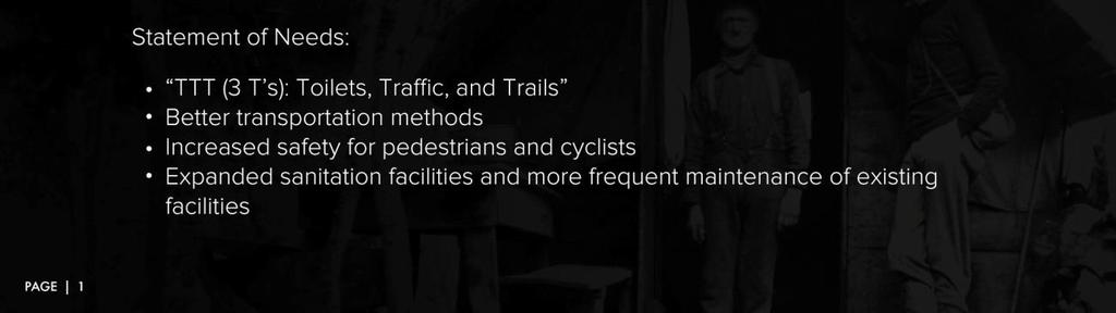
77 APPENDIX B: PRESENTATION SLIDES 76
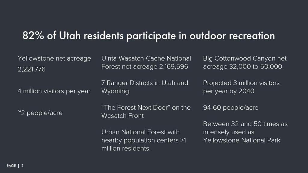
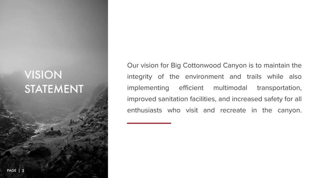
78 77
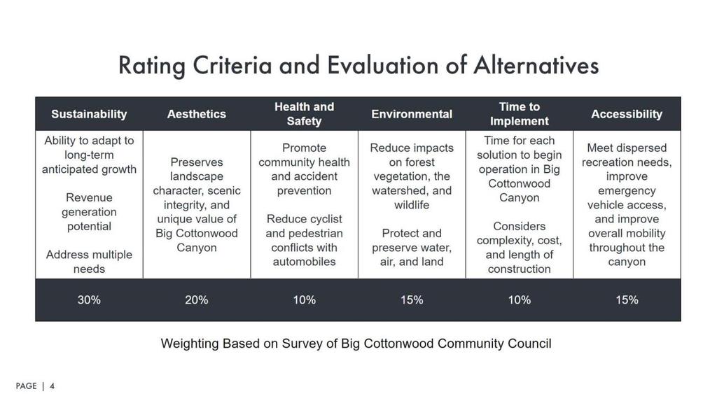
79 78
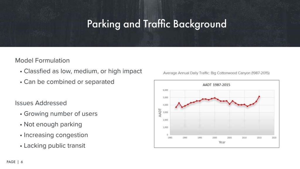
80 79
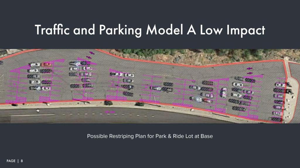
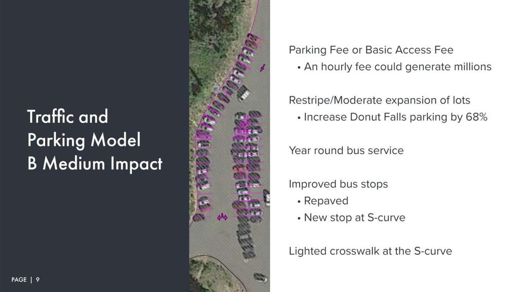
81 80
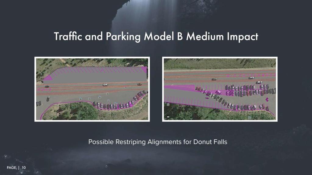
82 81
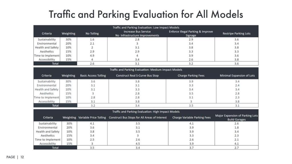
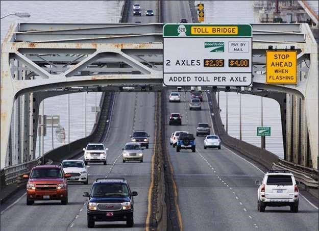
83 82
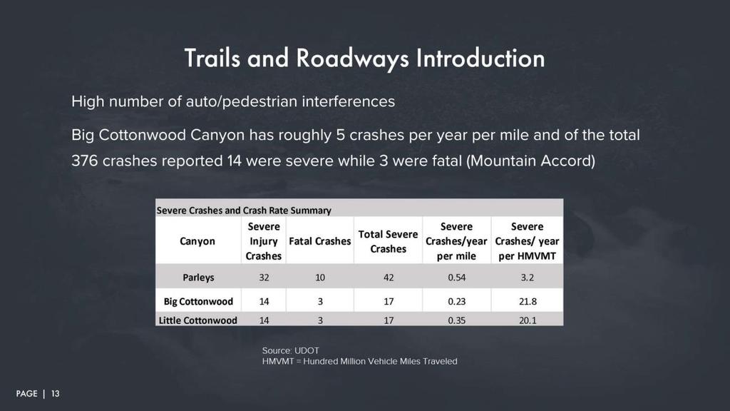
84 83
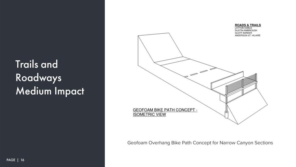
85 84
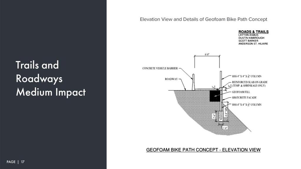

86 85
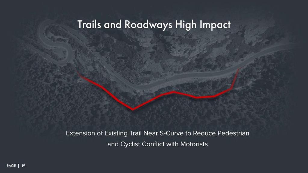
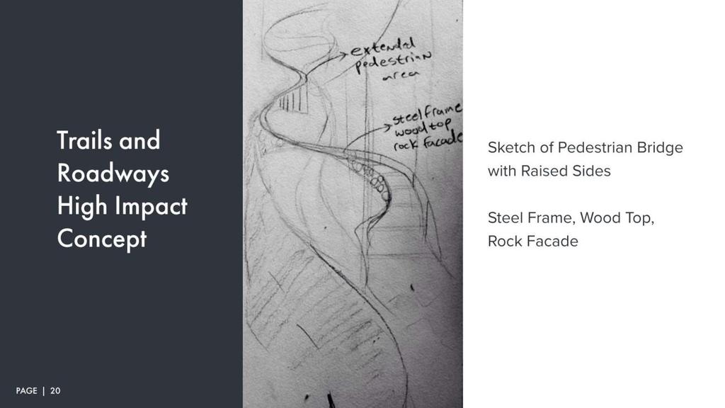
87 86
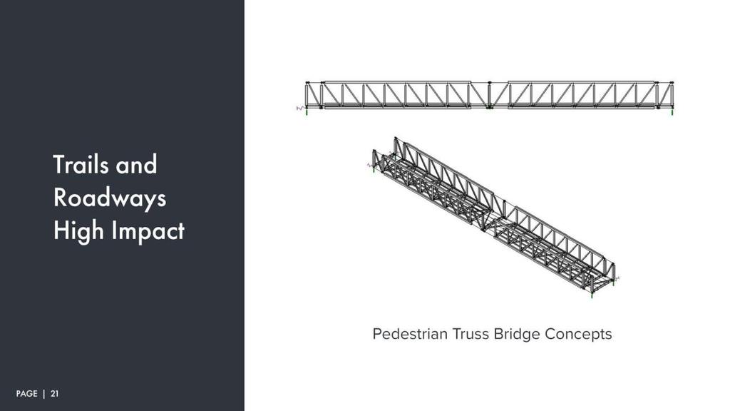
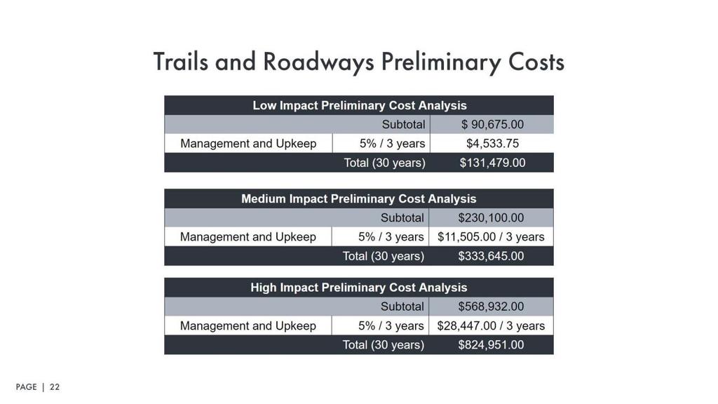
88 87
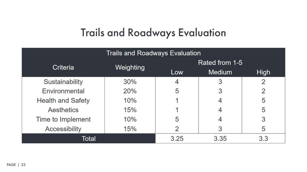
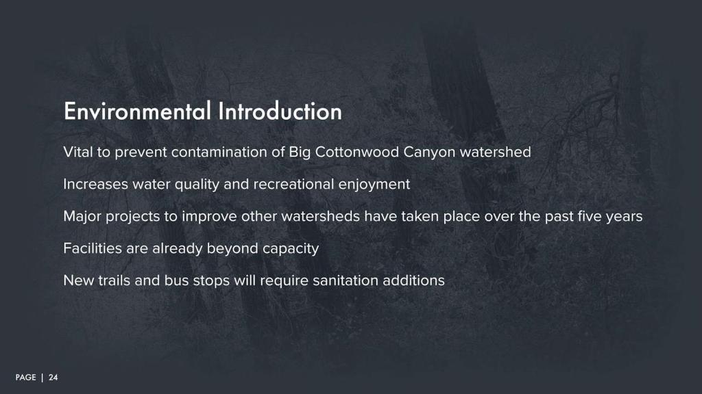
89 88
90 89
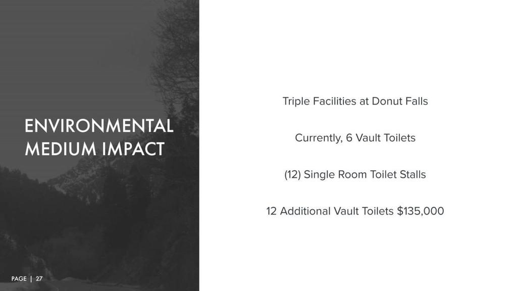
91 90
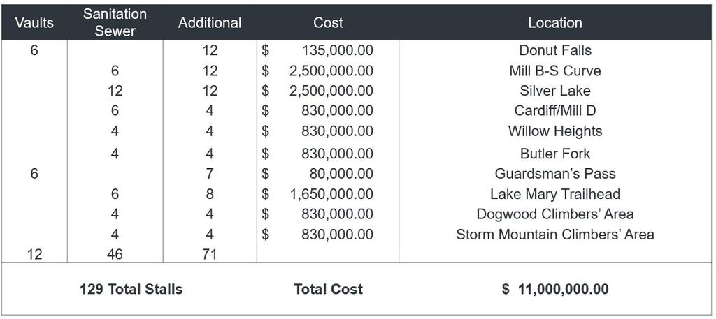
92 91
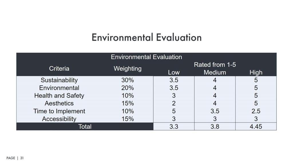
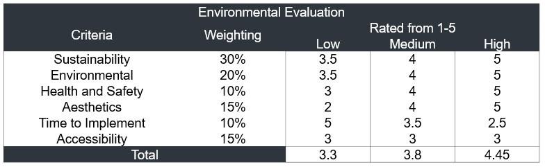
93 92
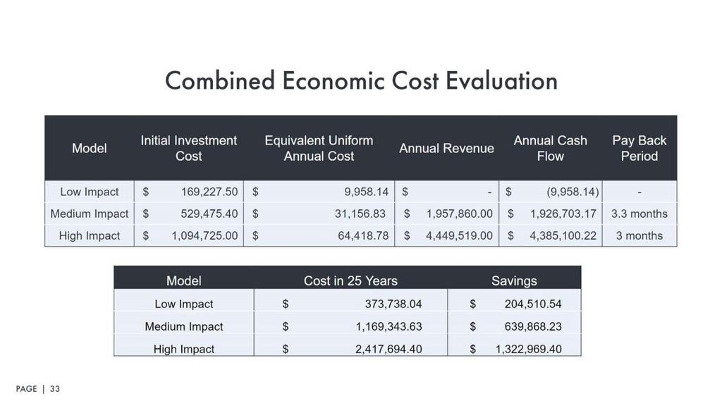
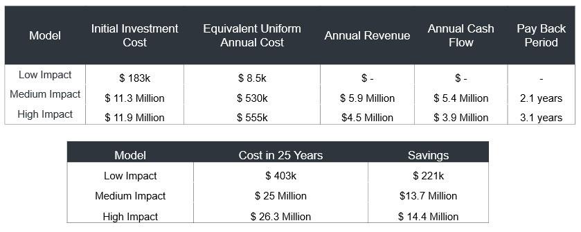
94 93
Develop a Multi-Modal Transportation Strategy (Theme 6)
") DEVELOP A MULTI-MODAL TRANSPORTATION STRATEGY (THEME 6) WHY IS THIS THEME ADDRESSED? Develop a Multi-Modal Transportation Strategy (Theme 6) Statement of Ideal Reduce resident and visitor reliance on single
DEVELOP A MULTI-MODAL TRANSPORTATION STRATEGY (THEME 6) WHY IS THIS THEME ADDRESSED? Develop a Multi-Modal Transportation Strategy (Theme 6) Statement of Ideal Reduce resident and visitor reliance on single
CONNECTING PEOPLE TO PLACES
 CONNECTING PEOPLE TO PLACES 82 EAST BENCH MASTER PLAN 07 Introduction The East Bench transportation system is a collection of slow moving, treelined residential streets and major arteries that are the
CITY OF COCOA BEACH 2025 COMPREHENSIVE PLAN. Section VIII Mobility Element Goals, Objectives, and Policies
 CITY OF COCOA BEACH 2025 COMPREHENSIVE PLAN Section VIII Mobility Element Goals, Objectives, and Policies Adopted August 6, 2015 by Ordinance No. 1591 VIII MOBILITY ELEMENT Table of Contents Page Number
Transportation Master Plan Advisory Task Force
 Transportation Master Plan Advisory Task Force Network Alternatives & Phasing Strategy February 2016 BACKGROUND Table of Contents BACKGROUND Purpose & Introduction 2 Linking the TMP to Key Council Approved
Pennsylvania Avenue (CR 484) Design Alternatives Study
 Design Alternatives Study") MEMORANDUM Pennsylvania Avenue (CR 484) Design Alternatives Study Prepared for: APRIL 2016 Prepared By TABLE OF CONTENTS Project Background... 2 Previous Concept... 2 Existing Conditions... 4 New Alternatives...
MEMORANDUM Pennsylvania Avenue (CR 484) Design Alternatives Study Prepared for: APRIL 2016 Prepared By TABLE OF CONTENTS Project Background... 2 Previous Concept... 2 Existing Conditions... 4 New Alternatives...
Purpose and Need. Chapter Introduction. 2.2 Project Purpose and Need Project Purpose Project Need
 Chapter 2 Purpose and Need 2.1 Introduction The El Camino Real Bus Rapid Transit (BRT) Project (Project) would make transit and other transportation improvements along a 17.6-mile segment of the El Camino
Circulation in Elk Grove includes: Motor vehicles, including cars and trucks
 Circulation, as it is used in this General Plan, refers to the many ways people and goods move from place to place in Elk Grove and the region. Circulation in Elk Grove includes: Motor vehicles, including
PEDESTRIAN ACTION PLAN
 ATTACHMENT 2 CITY OF SANTA MONICA PEDESTRIAN ACTION PLAN CITY OF SANTA MONICA PEDESTRIAN ACTION PLAN This page intentionally left blank EXECUTIVE SUMMARY CHAPTER 1 EXECUTIVE SUMMARY Setting the Stage
Public Information Centre
 WELCOME Public Information Centre Father Tobin Road Lougheed Middle School - Library Wednesday November 7, 2012 7:00 p.m.to 9:00 p.m. Please sign in Neighbourhood Traffic Calming Guide Background The City
Exhibit 1 PLANNING COMMISSION AGENDA ITEM
 Exhibit 1 PLANNING COMMISSION AGENDA ITEM Project Name: Grand Junction Circulation Plan Grand Junction Complete Streets Policy Applicant: City of Grand Junction Representative: David Thornton Address:
North Coast Corridor:
 North Coast Corridor: Connecting People, Transportation & Environment Legislative Hearing: 11.8.10 1 North Coast Corridor Region s Lifeline A Regional Strategy Mobility, Economy & Environment North Coast
EUCLID AVENUE PARKING STUDY CITY OF SYRACUSE, ONONDAGA COUNTY, NEW YORK
 EUCLID AVENUE PARKING STUDY CITY OF SYRACUSE, ONONDAGA COUNTY, NEW YORK CITY OF SYRACUSE DEPARTMENT OF PUBLIC WORKS 1200 CANAL STREET EXTENSION SYRACUSE, NEW YORK 13210 DRAFT REPORT DATE: November 13,
DRAFT. Memo. Range of the Alternatives Considered in the EIS
 Memo Date: Friday, December 09, 2016 Project: To: From: Subject: State Route 30 EIS UDOT Vince Izzo This memorandum summarizes the draft State Route (S.R.) 30 Level 1 screening results. A more detailed
Active Transportation Infrastructure Investment A Business Case
 Active Transportation Infrastructure Investment A Business Case In 2016, the Real Estate Foundation awarded the Capital Regional District a $50,000 grant for Shifting Gears: Land Use Change through Active
Clackamas County Comprehensive Plan
 ROADWAYS The County s road system permits the movement of goods and people between communities and regions, using any of a variety of modes of travel. Roads provide access to virtually all property. They
Corpus Christi Metropolitan Transportation Plan Fiscal Year Introduction:
 Introduction: The Safe, Accountable, Flexible, Efficient Transportation Equity Act: A Legacy for Users (SAFETEA-LU) has continued the efforts started through the Intermodal Surface Transportation Efficiency
CITY OF BLOOMINGTON COMPLETE STREETS POLICY
 CITY OF BLOOMINGTON COMPLETE STREETS POLICY POLICY OBJECTIVE: The City of Bloomington will enhance safety, mobility, accessibility and convenience for transportation network users of all ages and abilities,
City of Novi Non-Motorized Master Plan 2011 Executive Summary
 City of Novi Non-Motorized Master Plan 2011 Executive Summary Prepared by: February 28, 2011 Why Plan? Encouraging healthy, active lifestyles through pathway and sidewalk connectivity has been a focus
TRAVEL PLAN: CENTRAL EUROPEAN UNIVERSITY CAMPUS REDEVELOPMENT PROJECT TRAVEL PLAN. Central European University Campus Redevelopment Project.
 TRAVEL PLAN Central European University Campus Redevelopment Project Page 1 Table of Contents Introduction... 3 Background... 7 Building Users... 7 Transportation in Community Consultation... 7 Summary
TRANSPORTATION NEEDS ASSESSMENT
 TRANSPORTATION NEEDS ASSESSMENT A travel demand analysis was carried out to determine the operational issues and the potential benefit that adding traffic capacity would have on the road network. All the
Vision: Traditional hamlet with an attractive business/pedestrian friendly main street connected to adjacent walkable neighborhoods
 N D. Focus Area II Vision: Traditional hamlet with an attractive business/pedestrian friendly main street connected to adjacent walkable neighborhoods Transit Road Focus Area II is located in the Hamlet
2. Context. Existing framework. The context. The challenge. Transport Strategy
 Transport Strategy Providing quality connections Contents 1. Introduction 2. Context 3. Long-term direction 4. Three-year priorities 5. Strategy tree Wellington City Council July 2006 1. Introduction Wellington
Tonight is for you. Learn everything you can. Share all your ideas.
 Strathcona Neighbourhood Renewal Draft Concept Design Tonight is for you. Learn everything you can. Share all your ideas. What is Neighbourhood Renewal? Creating a design with you for your neighbourhood.
Proposed. City of Grand Junction Complete Streets Policy. Exhibit 10
 Proposed City of Grand Junction Complete Streets Policy Exhibit 10 1 City of Grand Junction Complete Streets Policy Vision: The Complete Streets Vision is to develop a safe, efficient, and reliable travel
Appendix A: Crosswalk Policy
 Appendix A: Crosswalk Policy Appendix A: Crosswalk Policy Introduction This citywide Crosswalk Policy is aimed at improving pedestrian safety and enhancing pedestrian mobility by providing a framework
Encouragement. Chapter 4. Education Encouragement Enforcement Engineering & Facilities Evaluation & Planning. Encouragement Chapter 4
 Encouragement Education Encouragement Enforcement Engineering & Facilities Evaluation & Planning Photo above: Children show off their ribbons at the Tour de Virginia Beach. Virginia Beach Bikeways and
RM 620 FEASIBILITY STUDY
 RM 620 FEASIBILITY STUDY Sections 5 & 6 December 7, 2015 STUDY PROCESS Study Purpose and Goals The RM 620 Feasibility Study was launched by the Texas Department of Transportation (TxDOT) to analyze transportation
Route 7 Corridor Study
 Route 7 Corridor Study Executive Summary Study Area The following report analyzes a segment of the Virginia State Route 7 corridor. The corridor study area, spanning over 5 miles in length, is a multi
University of Victoria Campus Cycling Plan Terms of Reference. 1.0 Project Description
 University of Victoria Campus Cycling Plan Terms of Reference 1.0 Project Description The Campus Cycling Plan, a first for the University, will provide a comprehensive and coordinated approach to support
5. RUNNINGWAY GUIDELINES
 5. RUNNINGWAY GUIDELINES These guidelines should be considered collectively when making runningway decisions. A runningway is the linear component of the transit system that forms the right-of-way reserved
May 12, 2016 Metro Potential Ballot Measure Issue Brief: Local Return
 Summary: Local return is an important revenue source for cities to maintain their local transportation infrastructure. Most cities use their local return to operate small bus systems and repave streets,
The District Municipality of Muskoka 70 Pine Street Bracebridge ON P1L 1N3
 Public Information Centre Summary Report Muskoka Road 15 (Santa s Village Road) Transportation Improvements from the Beaver Creek Bridge to the Entrance of Santa s Village The District Municipality of
Improving Mobility Without Building More Lanes
 Improving Mobility Without Building More Lanes By Mike Salisbury and Will Toor July 2017 Copyright 2017 by Southwest Energy Efficiency Project. All rights reserved. Photo: Courtesy of the Denver Post Anyone
8 PROPOSED ROUNDABOUT DUFFERIN STREET AND KING VAUGHAN ROAD INTERSECTION CITY OF VAUGHAN
 8 PROPOSED ROUNDABOUT DUFFERIN STREET AND KING VAUGHAN ROAD INTERSECTION CITY OF VAUGHAN The Transportation Services Committee recommends the adoption of the recommendation contained in the following report
East Burke Transportation, Safety and Capacity Improvements
 East Burke Transportation, Safety and Capacity Improvements The purpose of this project is to increase mobility and improve safety for pedestrians, cyclists, and motor vehicles along VT Route 114 in the
Chapter 3 DESIGN SPECIFICATIONS
 Brampton PathWays Planning and Design Guidelines 27 Chapter 3 DESIGN SPECIFICATIONS 3.1 CLASS 1 MULTI-USE PATH Off-road multi-use trails are the backbone of the Brampton PathWays Network. They are typically
Cherry Creek Transportation and Land Use Forum September 25, 2013 Meeting Summary
 Cherry Creek Transportation and Land Use Forum September 25, 2013 Meeting Summary I. LEAD-IN TO SMALL GROUP DISCUSSION, POLLING AND STEERING COMMITTEE/TECHNICAL TASK FORCE DISCUSSION The meeting began
Briefing Paper: ONE Wasatch Ski Interconnect Concept
 Briefing Paper: ONE Wasatch Ski Interconnect Concept Purpose and Audience The purpose of this briefing paper is to provide information on the ONE Wasatch proposal for discussion purposes. The intent is
MAG Town of Cave Creek Bike Study Task 6 Executive Summary and Regional Significance Report
 Page 1 MAG Town of Cave Creek Bike Study Task 6 Executive Summary and Regional Significance Report August 1, 2012 MAG Project #481 Page 2 Task 6 Executive Summary and Regional Significance Report Introduction
CITY OF SAINT JOHN TRAFFIC CALMING POLICY
 CITY OF SAINT JOHN TRAFFIC CALMING POLICY VERSION: 1.0 April 10, 2012 Pedestrians, Cyclists and Motorists Sharing Street Spaces CONTENTS INTRODUCTION... 3 POLICY GOAL... 3 POLICY OBJECTIVES... 3 GUIDING
Bluffdale South (SR140) Bicycle/Shoulder Lanes Project Type Bicycle
 Bicycle/Shoulder Lanes Project Type Bicycle") Bluffdale 14600 South (SR140) Bicycle/Shoulder Lanes Project Type Bicycle From Pony Express to UPRR Bridge over SR-140 $ 669,700 $ 624,361 To build bicycle/shoulder lanes on SR-140. SR-140 is an official
Bluffdale 14600 South (SR140) Bicycle/Shoulder Lanes Project Type Bicycle From Pony Express to UPRR Bridge over SR-140 $ 669,700 $ 624,361 To build bicycle/shoulder lanes on SR-140. SR-140 is an official
Town of Mooresville, North Carolina Neighborhood Traffic Calming and Control Device Policy
 Town of Mooresville, North Carolina Neighborhood Traffic Calming and Control Device Policy Adopted January 6, 2014 Town of Mooresville Development Services Department TOWN OF MOORESVILLE NEIGHBORHOOD TRAFFIC
Case Study: Transportation Plan Environmental Impact Statement. National Park Service U.S. Department of the Interior
 National Park Service U.S. Department of the Interior Grand Teton National Park Wyoming Case Study: Transportation Plan Environmental Impact Statement November 2010 Brian T. Alward CRP 5540: Introduction
AGENDA REPORT. Issue: Discussion of potential improvements on Barnwell Road at Niblick Drive
 AGENDA REPORT To: From: By: Honorable Mayor and City Council Members Warren Hutmacher, City Manager Tom Black, Public Works Director Date: March 23, 2016 Agenda: March 28, 2016 WORK SESSION AGENDA: Barnwell
Memorandum. Fund Allocation Fund Programming Policy/Legislation Plan/Study Capital Project Oversight/Delivery Budget/Finance Contract/Agreement Other:
 Memorandum Date: November 20, 2017 To: Transportation Authority Board From: Eric Cordoba Deputy Director Capital Projects Subject: 12/5/17 Board Meeting: San Francisco Freeway Corridor Management Study
Public Works Committee Meeting Richard E. Mastrangelo Council Chamber November 20, 2017
 Public Works Committee Meeting Richard E. Mastrangelo Council Chamber November 20, 2017 Purpose of Meeting Why are we here? Project Recap/Updates Project Limits/Segments Road Diet Concept Lessons Learned
Bicycle Master Plan Goals, Strategies, and Policies
 Bicycle Master Plan Goals, Strategies, and Policies Mobilizing 5 This chapter outlines the overarching goals, action statements, and action items Long Beach will take in order to achieve its vision of
Chapter 7. Transportation. Transportation Road Network Plan Transit Cyclists Pedestrians Multi-Use and Equestrian Trails
 Chapter 7 Transportation Transportation Road Network Plan Transit Cyclists Pedestrians Multi-Use and Equestrian Trails 7.1 TRANSPORTATION BACKGROUND The District of Maple Ridge faces a number of unique
EXECUTIVE SUMMARY... vii 1 STUDY OVERVIEW Study Scope Study Area Study Objectives
 Contents EXECUTIVE SUMMARY... vii 1 STUDY OVERVIEW... 1-1 1.1 Study Scope... 1-1 1.2 Study Area... 1-1 1.3 Study Objectives... 1-3 2 EXISTING CONDITIONS... 2-1 2.1 Existing Freeway Conditions... 2-4 2.1.1
Mineral Avenue Corridor Assessment. ITE 2017 Western District Annual Meeting San Diego, CA June 21 st
 Mineral Avenue Corridor Assessment ITE 2017 Western District Annual Meeting San Diego, CA June 21 st Biography - Aaron Heumann, PE, PTOE Currently City of Littleton Transportation Engineering Manager 24
WELCOME. Purpose of the Open House. Update you on the project. Present a draft recommended plan. Receive your input
 WELCOME Purpose of the Open House The Town of Smiths Falls has initiated the Beckwith Street Redevelopment Plan that includes the preparation of a streetscape functional design for the renewal of Beckwith
How To Encourage More Efficient Transportation in Brazilian Cities
 How To Encourage More Efficient Transportation in Brazilian Cities Todd Litman Victoria Transport Policy Institute Presented Seminar on Discouraging The Use Of Cars São Paulo, Brazil 3 September 2013 Creating
M-58 HIGHWAY ACCESS MANAGEMENT STUDY Mullen Road to Bel-Ray Boulevard. Prepared for CITY OF BELTON. May 2016
 M-58 HIGHWAY ACCESS MANAGEMENT STUDY Prepared for CITY OF BELTON By May 2016 Introduction Missouri State Highway 58 (M-58 Highway) is a major commercial corridor in the City of Belton. As development has
PROJECT FACT SHEET May 25, 2018
 SITE CHALLENGES & PROJECT BACKGROUND In 2014, the City of Aspen identified the Castle Creek Bridge and Hallam Street corridor as a deficient link in Aspen s bicycle and pedestrian network. Safe and efficient
EXECUTIVE SUMMARY. Vision
 Vision Walking and bicycling in Salt Lake City will be safe, convenient, comfortable, and viable transportation options that connect people to places, foster recreational and economic development opportunities,
Appendix C. TRAFFIC CALMING PROGRAM TOOLBOX
 Appendix C. TRAFFIC CALMING PROGRAM TOOLBOX PHASE I...2 Do Not Enter Sign...3 One-Way Sign...4 Turn Prohibition...5 Pavement Markings...6 Speed Monitoring Trailer...7 Neighborhood Speed Watch...8 Police
o n - m o t o r i z e d transportation is an overlooked element that can greatly enhance the overall quality of life for the community s residents.
 N o n - m o t o r i z e d transportation is an overlooked element that can greatly enhance the overall quality of life for the community s residents. 84 Transportation CHAPTER 11 INTRODUCTION Transportation
Living Streets Policy
 Living Streets Policy Introduction Living streets balance the needs of motorists, bicyclists, pedestrians and transit riders in ways that promote safety and convenience, enhance community identity, create
TRANSIT & NON-MOTORIZED PLAN DRAFT FINAL REPORT Butte County Association of Governments
 1 INTRODUCTION Maintaining a high quality of life is the essence of this plan for transit and non-motorized transportation in Butte County. Curbing greenhouse gas emissions (GHG) by reducing congestion,
WELCOME Public Information Centre
 WELCOME Public Information Centre Fernforest Drive Brampton Soccer Centre Community Room #2 Tuesday January 19, 2016 6:30 p.m.to 9:00 p.m. Please sign in Neighbourhood Traffic Calming Guide Background
Regional Transportation Needs Within Southeastern Wisconsin
 Regional Transportation Needs Within Southeastern Wisconsin #118274 May 24, 2006 1 Introduction The Southeastern Wisconsin Regional Planning Commission (SEWRPC) is the official areawide planning agency
MCTC 2018 RTP SCS and Madera County RIFP Multi-Modal Project Eval Criteria GV13.xlsx
 MCTC 8 RTP SCS and Madera County RIFP Multi-Modal Project Eval Criteria GV.xlsx Madera County Transportation Commission Regional Transportation Plan / Sustainable Communities Strategy Multi-Modal Project
BETHEL ROAD AND SEDGWICK ROAD CORRIDOR STUDY
 DRAFT PLAN City Council Meeting August 14, 2017 STUDY AREA Sedgwick Corridor State Route 160, principal arterial with Class 3 access management designation, commuter and freight route, connection to SR
Chapter 2: Standards for Access, Non-Motorized, and Transit
 Standards for Access, Non-Motorized, and Transit Chapter 2: Standards for Access, Non-Motorized, and Transit The Washtenaw County Access Management Plan was developed based on the analysis of existing
Kelowna On the Move. Pedestrian and Bicycle Master Plan
 Kelowna On the Move Pedestrian and Bicycle Master Plan Executive Summary April 2016 Purpose of the Plan The Pedestrian and Bicycle Master Plan identifies infrastructure, planning, and policy requirements
Summary of Comments Public Meeting: Marietta Street Resurfacing Project Atlanta Contemporary August 29, 2017 / 6:00 pm to 8:00 pm
 Renew Atlanta hosted a public meeting to discuss the Marietta Street Resurfacing project at. Councilmember Cleta Winslow attended the public meeting, where over seventy (70) citizens to include representatives
Climate Change Action Plan: Transportation Sector Discussion Paper: Cycling
 Climate Change Action Plan: Transportation Sector Discussion Paper: Cycling ontario.ca/climatechange Contents 1. Minister of Transportation s message... 3 2. Introduction... 5 3. Sector Overview and Support
Report to Cabinet. 18 May 2016
 Agenda Item 8 Report to Cabinet 18 May 2016 Subject: Presenting Cabinet Member: Proposed CCTV Enforcement of Traffic Contraventions in a Bus Lane (Key Decision Ref. No. HE030) Highways and Environment
Highway 217 Corridor Study. Phase I Overview Report
 Highway 217 Corridor Study Phase I Overview Report November 3, 24 BACKGROUND AND OVERVIEW Study purpose The Highway 217 Corridor Study is developing multi-modal transportation solutions for traffic problems
McKenzie Interchange Project Fall 2015 Engagement. Appendix 2: Engagement Materials and Feedback Form
 Fall 2015 Engagement Appendix 2: Engagement Materials and Feedback Form Welcome to the McKenzie Interchange Project Open House! Purpose of Open House To provide you with information regarding the project
MnPASS System Today and the Future
 MnPASS System Today and the Future April 2010 By Nick Thompson Minnesota Department of Transportation Topics Minnesota s Current and Future MnPASS High Occupancy Toll Systems Overview of the MnPASS System
CHAPTER 7.0 IMPLEMENTATION
 CHAPTER 7.0 IMPLEMENTATION Achieving the vision of the Better Streets Plan will rely on the ability to effectively fund, build and maintain improvements, and to sustain improvements over time. CHAPTER
Appendix C 3. Bicycle / Pedestrian Planning
 Appendix C 3. Bicycle / Pedestrian Planning BICYCLE/PEDESTRIAN PLANNING 2005 Master Plan GOAL: Provide for safe and convenient bicycle and pedestrian circulation throughout the City. Develop a city-wide
A CHANGING CITY. of Edmonton, it is essential that it reflects the long-term vision of the City.
 A CHANGING CITY By the year 2040, Edmonton will be home to more than 1 million people. To accommodate growth and support a healthy and compact city, we need a new approach to development/redevelopment
NACTO Designing Cities Conference Project Evaluation: Tools for Measuring Success and Building Support. October 29, 2015
 NACTO Designing Cities Conference Project Evaluation: Tools for Measuring Success and Building Support October 29, 2015 The case for evaluation: Have a social contract with City Council, staff and community
City of Elizabeth City Neighborhood Traffic Calming Policy and Guidelines
 City of Elizabeth City Neighborhood Traffic Calming Policy and Guidelines I. Purpose: The City of Elizabeth City is committed to ensure the overall safety and livability of residential neighborhoods. One
3.9 Recreational Trails and Natural Areas
 3.9 Recreational Trails and Natural Areas 3.9.1 Introduction Parks and other recreational facilities such as trails, bicycle routes, and open space are important community resources. This section discusses
Standing Committee on Policy and Strategic Priorities. Mount Pleasant Industrial Area Parking Strategy and Access Improvements
 POLICY REPORT Report Date: April 23, 2018 Contact: Lon LaClaire Contact No.: 604.873.7722 RTS No.: 9944 VanRIMS No.: 08-2000-20 Meeting Date: May 16, 2018 TO: FROM: SUBJECT: Standing Committee on Policy
4. ENVIRONMENTAL IMPACT ANALYSIS 9. TRANSPORTATION AND TRAFFIC
 4. ENVIRONMENTAL IMPACT ANALYSIS 9. TRANSPORTATION AND TRAFFIC 4.9.1 INTRODUCTION The following section addresses the Proposed Project s impact on transportation and traffic based on the Traffic Study
Safe Routes to School Action Plan Aberdeen, Idaho
 Background Aberdeen, Idaho is a largely agricultural community of nearly 2,000 people and is located in the southeast portion of the state on the western edge of American Falls Reservoir. The community
Planning Guidance in the 2012 AASHTO Bike Guide
 Planning Guidance in the 2012 AASHTO Bike Guide Presentation by: RJ Eldridge Peter Lagerwey August 22, 2012 WEBINAR 2: PLANNING GUIDANCE IN THE 2012 AASHTO BIKE GUIDE Today s Webinar Significant Updates
Solana Beach Comprehensive Active Transportation Strategy (CATS)
") Solana Beach Comprehensive Active Transportation Strategy (CATS) 3.0 Goals & Policies The Solana Beach CATS goals and objectives outlined below were largely drawn from the Solana Beach Circulation Element
Solana Beach Comprehensive Active Transportation Strategy (CATS) 3.0 Goals & Policies The Solana Beach CATS goals and objectives outlined below were largely drawn from the Solana Beach Circulation Element
NORTH HIGHLAND LAKE ROAD PROJECT
 NORTH HIGHLAND LAKE ROAD PROJECT The purpose of this special newsletter is to inform the residents of Flat Rock about the facts concerning the proposed N. Highland Lake Road Project and clarify some misconceptions.
PROJECT FACT SHEET March 21, 2018
 SITE CHALLENGES & PROJECT BACKGROUND In 2014, the City of Aspen identified the Castle Creek Bridge and Hallam Street corridor as a deficient link in Aspen s bicycle and pedestrian network. Safe and efficient
ALLEY 24 TRAFFIC STUDY
 ALLEY 24 TRAFFIC STUDY in City of Frostburg, Maryland January 2013 3566 Teays Valley Road Hurricane, WV Office: (304) 397-5508 www.denniscorporation.com Alley 24 Traffic Study January 2013 Frostburg, Maryland
CITY OF HAMILTON PUBLIC WORKS DEPARTMENT Transit Division
 CITY OF HAMILTON PUBLIC WORKS DEPARTMENT Transit Division TO: Chair and Members Public Works Committee COMMITTEE DATE: June 4, 2018 SUBJECT/REPORT NO: WARD(S) AFFECTED: PREPARED BY: SUBMITTED BY: Mountain
SELECTED ROADWAY CAPACITY ANALYSIS
 CHAPTERFOUR SELECTED ROADWAY CAPACITY ANALYSIS 4.1 SELECTED ROADWAY CAPACITY ANALYSIS Introduction Capacity analysis was performed on six selected roadways within the Dearborn County study area using the
Comments EXECUTIVE SUMMARY
 Comments 1. Under any Alternatives, MCDOT should provide better at-grade pedestrian crossing of Georgia Avenue and Forest Glen Road, including improved crosswalks with wider medians and adequate signal
Active Transportation Facility Glossary
 Active Transportation Facility Glossary This document defines different active transportation facilities and suggests appropriate corridor types. Click on a facility type to jump to its definition. Bike
South King County High-Capacity Transit Corridor Study
 HIGH-CAPACITY TRANSIT CORRIDOR STUDY South King County Corridor South King County High-Capacity Transit Corridor Study Corridor Report August 2014 South King County High Capacity Transit Corridor Report
Access Management in the Vicinity of Intersections
 Access Management in the Vicinity of Intersections FHWA-SA-10-002 Technical Summary Photo: Ralph Bentley (used with permission) 0 Access Management is: The design, implementation and management of entry
Evaluation and Changes to Pedestrian Priority Phase Signal (Scramble Crossing) at Bay Street and Bloor Street
 at Bay Street and Bloor Street") PW2.2 STAFF REPORT ACTION REQUIRED Evaluation and Changes to Pedestrian Priority Phase Signal (Scramble Crossing) at Bay Street and Bloor Street Date: February 12, 2015 To: From: Public Works and Infrastructure
PW2.2 STAFF REPORT ACTION REQUIRED Evaluation and Changes to Pedestrian Priority Phase Signal (Scramble Crossing) at Bay Street and Bloor Street Date: February 12, 2015 To: From: Public Works and Infrastructure
Shifting Gears for a Healthier City
 Shifting Gears for a Healthier City Mississauga s Cycling Master Plan is an ambitious strategy that sets out to transform Mississauga into a city that is conducive to cycling for daily transportation needs.
10.0 CURB EXTENSIONS GUIDELINE
 10.0 CURB EXTENSIONS GUIDELINE Road Engineering Design Guidelines Version 1.0 March 2017 City of Toronto, Transportation Services City of Toronto Page 0 Background In early 2014, Transportation Services
Broad Street Bicycle Boulevard Design Guidelines
 Broad Street Bicycle Boulevard Design Guidelines Building from the strategies introduced in the 2013 Bicycle Transportation Plan and community input received thus far, City Transportation Staff have identified
WEST AND SOUTH WEST RING ROAD DOWNSTREAM TRAFFIC IMPACTS
 Page 1 of 9 EXECUTIVE SUMMARY Alberta Transportation ( AT ) is preparing to construct the final sections of the Calgary Ring Road. This includes the South West Ring Road ( SWRR ) (from Lott Creek Blvd
Chapter VISION, MISSION, AND GOALS AND OBJECTIVES. Vision. Mission. Goals and Objectives CONNECTING COMMUNITIES ACROSS THE ST.
 VISION, MISSION, AND GOALS AND OBJECTIVES Chapter 3 The Plan s vision, mission, and goals and objectives were developed through a series of interactive exercises with the Citizens Advisory Committee (CAC)
Traffic Calming Policy
 Article I. Purpose and Goal. The purpose of this policy is to establish criteria and procedures the City will use to evaluate requests for, and if appropriate, implement traffic calming measures. Neighborhood
Preliminary Transportation Analysis
 Preliminary Transportation Analysis Goals of a Robust, Multimodal Transportation Network Safe Accessible/Connected Efficient Comfortable Context-Sensitive Motor Vehicle: Continue to analyze the data to
Appendix A. Road Classification Review of Outstanding Issues and Proposed Classifications (All Wards) Staff Report Road Classification System
 Staff Report Road Classification System") Appendix A Road Classification Review of Outstanding Issues and Proposed Classifications (All Wards) Staff Report 2000 A.1 of A.10 A.2 of A.10 STAFF REPORT January 26, 2000 To: From: Works Committee Barry
Appendix A Road Classification Review of Outstanding Issues and Proposed Classifications (All Wards) Staff Report 2000 A.1 of A.10 A.2 of A.10 STAFF REPORT January 26, 2000 To: From: Works Committee Barry