3. Circulation Element
|
|
|
- Ashley Thornton
- 5 years ago
- Views:
Transcription
1 3. Circulation Element
2 This page intentionally left blank.

3 Chapter 3. Circulation INTRODUCTION Purpose and Function A s development continues in the City of Highland, traffic on its roadway systems will increase. To protect the City s unique character and ensure the safe and efficient movement of people and goods, careful planning of the roadway network is essential. As the City s road system nears its capacity for handling traffic in a safe and efficient manner, the potential for delays and the risk of traffic accidents increase. The Circulation Element addresses current transportationrelated issues and future challenges associated with the growth posed by the General Plan. In addition, the Circulation Element analyzes future traffic impacts to the City due to the planned growth of Highland s Land Use Plan and the inevitable growth region-wide. The purpose of the Circulation Element is to develop an efficient, cost effective and comprehensive transportation management strategy, consistent with regional plans and local needs to maintain and improve mobility, and in a manner consistent with the goals and character of the community. The Circulation Element provides specific implementation programs, which address the existing traffic conditions in the General Plan study area, and are designed to prevent future deterioration of roadway capacity in the community. California Government Code describes conditions and data to be researched, analyzed and included within a General Plan Circulation Element. Government Code Section 65302(b) states that the General Plan shall include the general location and extent of existing and proposed major thoroughfares, transportation routes, terminals and other local public utilities and facilities. Related Plans and Programs Other Elements The Circulation Element is an outgrowth of City and regional land use planning. It also affects and is affected by a variety of community and environmental factors. The element has a direct relationship with the City of Highland General Plan 3-1
4 HIGHLAND A Great Place to Live Land Use, Public Services and Facilities, Open Space and Conservation, Noise, Economic Development, and Community Design Elements. The circulation system is a primary determinant in shaping land use patterns specified in the Land Use Element and, conversely, its capacity is designed to accommodate the Land Use Element s land use distributions and intensities. The various community facilities and services addressed in the Public Services and Facilities Element, including fire and police services, public and private utilities and educational facilities, are all affected and served by the circulation system. Traffic impacts on air quality are well known. Strategies to address this issue are discussed in the Open Space and Conservation Element. The roadway network and travel patterns define noise contours along roadways and, as such, shape the goals and policies of the Noise Element. An efficient, safe and effective circulation system is an essential component to the economic health of any city. Its ability to move employees, visitors and goods has a direct correlation to the goals and policies of the Economic Development Element. While mobility is an important overarching goal of the Circulation Element, preservation of City character and pedestrian safety must be maintained. The design of local streets and places where people congregate must ensure public safety. As such, the Circulation and Community Design Elements are inextricably linked. Regional Planning The Circulation Element is also the result of coordination with the Regional Transportation Plan (RTP) and state and regional agencies, including the California Department of Transportation (Caltrans), the San Bernardino Association of Governments (SANBAG), and the Southern California Association of Governments (SCAG). It is also influenced through close coordination with neighboring local jurisdictions, such as the Cities of San Bernardino and Redlands, the San Bernardino International Airport Authority, and San Manuel Band of Mission Indians. In addition, federal and state transportation planning must be coordinated with local planning pursuant to Section 134, Title 23 of the U.S. Code and California Government Code Section 65080(a), respectively. 3-2 March 2006 City of Highland General Plan
5 3. CIRCULATION ELEMENT Protection of air quality is also associated with growing traffic volumes and infrastructure demand, and requires careful analysis and planning to protect the community from unnecessarily high levels of locally generated pollutants. Vehicular emissions will increase with expanding population, miles traveled and less efficient travel conditions. However, the maintenance of adequate traffic flows, the prevention of traffic congestion caused by inadequate and/or failing roadways, and enhanced vehicle efficiencies will help preserve the air quality in the community. SCAG Regional Transportation Plan DESITINATION 2030 is the 2004 Regional Transportation Plan (RTP) for the six-county Region in southern California, including Los Angeles, Orange, San Bernardino, Riverside, Ventura and Imperial Counties home to 17 million people. The Regional Transportation Plan (RTP) is the culmination of a three-year effort with a focus on improving the balance between land use and the current, as well as future, transportation systems. SCAG is required to develop, maintain and update the RTP on a three-year cycle. DESTINATION 2030 is a multimodal plan representing the regional vision for a better transportation system, integrated with the growth pattern for the region over the Plan horizon of The Plan provides the basic policy and program framework for long-term investment in the vast regional transportation system in a coordinated, cooperative and continuous manner. Transportation investments in the SCAG region that receive state or federal transportation funds must be consistent with the RTP and must be included in the Regional Transportation Improvement Program (RTIP) when ready for funding. The Highland General Plan has been developed with SCAG Regional Transportation Plan in mind. The implementation of the General Plan s goals and policies are designed to incorporate policy to achieve the City s role in regional transportation planning. CIRCULATION PLAN The Circulation Plan describes the approach to be used in implementing the Circulation Element s goals and policies, as well as the location and extent of circulation facilities and services. As a comprehensive transportation management strategy, the Circulation Element has been developed based upon an analysis of existing conditions within the City, and future development as set forth by the General Plan Land Use Plan and growth projections. Growth in traffic has been projected based upon the East Valley Traffic Model (EVTM), administrated by City of San Bernardino and especially updated for the City of Highland. City of Highland General Plan 3-3

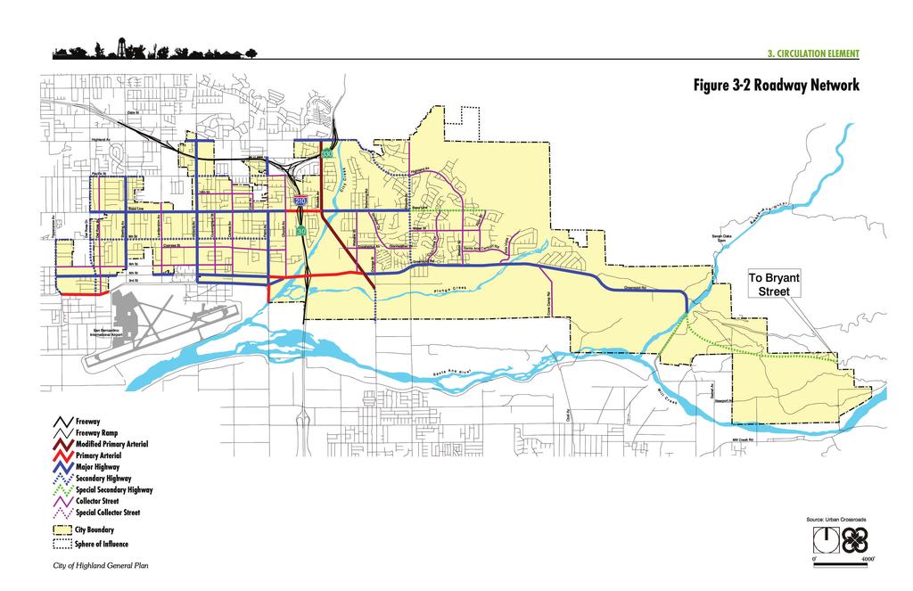
6 HIGHLAND A Great Place to Live Roadway Classifications Based upon existing and projected traffic demands generated by buildout of the General Plan, each major roadway has been assigned a specific design classification. The need for and appropriateness of each classification has been based upon modeled future traffic volumes and overall community design goals set forth in the General Plan. Each of the classifications corresponds with the typical street cross-sections illustrated in Figure 3.1, Roadway Cross-Sections. While the crosssections represent typical street widths, refinements may be required at intersections or entrances to development projects, which could include the need for additional travel or turn lanes, as well as provisions for transit improvements. There are seven categories in the City roadway hierarchy, ranging from higher capacity primary arterials to lower capacity collector streets. These categories are described below: Collector Street. This category of roadway is intended to carry traffic between residential neighborhoods and the larger street network. They are, generally, two-lane roadways which have a mixture of residential and commercial land uses along them. Collector streets are 44 feet, curb-to-curb, within 66-foot rights-of-way. Examples of collector streets are Church Avenue and Weaver Street. Cunningham Street is wider (more than 50 feet) than the typical cross-section for most of its segments. Looking north on Palm Avenue, a Special Collector Street, in Highland s Historic Village District. Special Collector Street. Palm Avenue is designated as a special collector street in the area between the Base Line and Pacific Street. This section of Palm Avenue serves as the primary connection between the Town Center and Historic Village District and, in some areas, is constrained by existing historic structures in the area. This is a two-lane roadway with a 52-foot roadway, curb-to-curb, within a 66-foot right-of-way. Restrictions on the amount and design of on-street parking within the Historic Village Area are anticipated. It is also expected that the increase in pedestrian movement in the area may necessitate the installation of pedestrian crossings or signals, which will reduce the efficiency in this section of the roadway system. If on-street parking is eliminated, a narrower curb-to-curb crosssection could be utilized, allowing the available right-of-way to be used to augment pedestrian amenities (e.g., wider sidewalks with room available for street furniture and other enhancements). 3-4 March 2006 City of Highland General Plan
7
8 HIGHLAND A Great Place to Live This page intentionally left blank. 3-6 March 2006 City of Highland General Plan
. Alternatively, the City may accept a reduced LOS to retain the historic character of the District.")

9 3. CIRCULATION ELEMENT Because of the location of the intersection of Palm Avenue and Pacific Street and right-of-way constraints within the Historic Village District, consideration may be given to alternatives to traffic signals as a method to achieve acceptable levels of service (LOS). Alternatively, the City may accept a reduced LOS to retain the historic character of the District. Special Secondary Highway. The portion of Base Line between Church Street and Greenspot Road is identified as requiring special secondary highway status. This section of roadway is designated as containing a 66-foot roadway, curb-to-curb, within a 104-foot right-of-way. This section provides more space for pedestrian and landscape improvements. Secondary Highway. Secondary highways provide more local access than major arterials, but also provide some nonlocal throughtraffic service. This classification includes a four-lane roadway with a raised median and has a typical right-of-way width of 88 feet and a curb-to-curb pavement width of approximately 64 feet. Del Rosa Drive, Tippecanoe Avenue, Pacific Street, 9 th Street and Church Street are examples of secondary highways. The alternative secondary highway cross-section does not include a raised median but enhances the opportunity to provide bike paths and/or parking lanes. Table 3.1 summarizes the different cross-section configurations for all secondary highways in the City of Highland. Looking east on Base Line, identified as a Special Secondary Highway, at its intersection with Church Street. Table 3.1: Secondary Highway Configuration Roadway Median Bike Path Parking Lane Pacific Street No Class II No 9 th Street No Class III Yes Tippecanoe Avenue No Class II No Del Rosa Drive Yes No No Highland Avenue Yes Class II No Church Street No Class II No Orange Street No Class II No Major Highway. Major highways provide service to nonlocal through trips, as well as providing limited local access. Ideally, curb cuts are minimized on major arterials, although historically such access control has been difficult to achieve. Major highways are designated as four-lane, 80-foot roadways (including a 12-foot median) curb-to-curb, within 104-foot rights-of-way. Looking east on Base Line at Central Avenue. This portion of Base Line is identified as a major highway. City of Highland General Plan 3-7

10 HIGHLAND A Great Place to Live Base Line (west of Church Avenue and between Boulder Avenue and Church Street) and most of Greenspot Road are examples of major highways. Base Line, from the western City limit to Palm Avenue, will retain a 72-foot curb-to-curb cross-section. The median on Base Line from Browning Road to Church Street will have a reduced width due to local topography. Primary Arterial. Primary arterials are limited access facilities which provide service to nonlocal through trips with a minimal level of direct access to adjacent land uses. They are designated as 96-foot roadways, curb-to-curb, within a minimum of 112-foot rights-of-way, and carry up to three lanes of through traffic in each direction. An example of a primary arterial is 5 th Street between Palm Avenue and Boulder Avenue. This portion of 5 th Street is identified as a Primary Arterial. Modified Primary Arterial. Boulder Avenue north of Greenspot Road is designated as a modified primary arterial. The modified primary arterial is designated as a four-lane divided roadway plus a Class I bike lane, with a typical right-of-way width of 135 feet and a curb-to-curb pavement width of approximately 98 feet with a raised median. Typical cross-sections for roadway classifications are provided in Figure 3.1, Roadway Cross-Sections. Actual cross-sections may vary somewhat from the indicated measurement standards, but in order to provide maximum capacity, as well as right-of-way protection for landscaping, bike lanes and future roadway improvements, the typical roadway crosssections are recommended as future minimums. Regional Roadways State Route 30 (SR-30) represents the backbone of Highland s circulation system and must be considered in any significant changes to land use or design. The process to add SR-30 to Interstate 210 (I-210) began in 1998, when the designation of SR-30 was legislatively changed to California 210 (AB 2388, 1998). In 1999, the state of California submitted California 210 for inclusion in the Interstate Highway System. The American Association of State Highway and Transportation Officials (AASHTO) rejected this proposal because the freeway segments were not complete; however, the freeway will be resubmitted for approval once it is complete. The City of Highland and surrounding jurisdictions may also seek funding and approval for the freeway s expansion from four to six or more lanes to accommodate the expected increase in future traffic. The connection of I-210 with SR-30 construction will be completed by the end of The regional long-range projections indicate that SR-30 through Highland will need to be widened to six lanes. Measure I, the 3-8 March 2006 City of Highland General Plan
11 3. CIRCULATION ELEMENT local funding source for building new freeways and widening existing routes, includes a widening project for SR-30 from I-215 to I-10. The SR-30 widening will include an additional general use lane in each direction. Levels of Service The available and utilized capacity of a roadway is typically characterized as Level of Service. Level of Service (LOS) is a qualitative measure describing the efficiency of the flow of traffic. LOS includes the range of alphabetical connotations A through F, used to characterize roadway operating conditions. LOS A represents the best (free flow) conditions and LOS F indicates the worst (system failure). Level of Service can also be represented as volume to capacity (V/C) ratios, or vehicle demand divided by roadway capacity. Therefore, as the ratio approaches 1.00, the roadway approaches LOS F. The V/C ratio is the ratio of existing or projected traffic volumes to an intersection s design capacity. Peak hours include those times of day where the traffic volumes are the highest; typically they are in the morning and evening hours when most people are traveling to and from their places of employment. Table 3.2 describes the quality of traffic flow associated with each level of service. Table 3.2: Level of Service Description Average Total Delay Level of Per Vehicle (Seconds) Service Quality of Traffic Flow Signalized Unsignalized V/C Ratio A Represents free flow. Individual users are virtually unaffected by the presence of others in the traffic stream B In the range of stable flow, but the presence of other users in the traffic stream begins to be noticeable. Freedom to select desired speeds is relatively unaffected, but there is a slight decline in the freedom to maneuver. C In the range of stable flow, but marks the beginning of the range of flow in which the operation of individual users becomes significantly affected by interactions with others in the traffic stream. D Represents high-density but stable flow. Speed and freedom to maneuver are severely restricted, and the driver experiences a generally poor level of comfort and convenience. E Represents operating conditions at or near the capacity level. All speeds are reduced to a low, but relatively uniform value. Small increases in flow will cause breakdowns in traffic movement. F Used to define forced or breakdown flow. This condition exists wherever the amount of traffic approaching a point exceeds the amount that can traverse the point. Queues form behind such locations and up and up Above 1.00 Note: The criteria used to evaluate LOS conditions vary based on the type of roadway and whether the traffic flow is considered interrupted or uninterrupted. City of Highland General Plan 3-9
12 HIGHLAND A Great Place to Live This Circulation Element establishes that the LOS should be LOS D or better for major intersections in the City. For peak operating periods, LOS D is considered acceptable. Therefore, any City of Highland intersection operating at LOS E or F is considered deficient March 2006 City of Highland General Plan
13
14 HIGHLAND A Great Place to Live This page intentionally left blank March 2006 City of Highland General Plan
15 3. CIRCULATION ELEMENT GOALS AND POLICIES The following section identifies critical transportation issues and circulation components, maps various circulation network components, and provides goals and policies that support the City s vision of an efficient transportation system that serves all of Highland s residents, businesses and visitors. Roadway Mobility/Transportation Demand Management As the San Bernardino Valley and the community continue to grow, transportation demand and systems management is necessary to preserve and increase available roadway capacity. Highland must provide and maintain a roadway system with adequate capacity and acceptable levels of service to accommodate projected travel demands associated with the buildout of the Land Use Element. This can be accomplished by establishing minimum service levels for the designated roadway system and implementing Transportation Demand Management (TDM) strategies. TDM involves the development and implementation of policies, plans and programs designed to encourage the use of a wider range of transportation alternatives, including public transit and bicycles. In addition to an emphasis on alternative travel modes such as carpooling, van pooling and mass transit, TDM can also include employee flex time as an important component that reduces peak hour travel and associated traffic congestion. In response to state mandates, SANBAG prepared a regional Congestion Management Plan (CMP), which required City of Highland and other cities to prepare TDM ordinances or risk the loss of federal transportation funds. The City adopted its TDM ordinance in April, GOAL 3.1 Provide a comprehensive transportation system that facilitates current and long-term circulation in and through the City. Policies 1) Require new development proposals to ensure that all mid-block street segments operate at LOS D or better during the peak hours of traffic. (Note: Because of the location of the Palm Avenue/Pacific Street intersection within the Historic District, consideration will be given to alternatives to traffic signal mitigation. Alternatively, the City may elect to accept a lower LOS to retain the historic character of the District.) City of Highland General Plan 3-13
16 HIGHLAND A Great Place to Live 2) Ensure that all intersections operate at LOS D or better during the peak hours of traffic. 3) Ensure that the City s street system be designed and constructed to accommodate the traffic generated by buildout of the General Plan land use designations. 4) Maintain flexibility in the cross-sections and configuration of streets within topographically rugged or environmentally sensitive areas as long as mid-block street segments and intersections operate at LOS D or better. 5) Design and employ traffic control measures (e.g., install traffic signals, provide access restrictions, etc.) to ensure city streets and roads function as intended. 6) Periodically update the General Plan master traffic study to maintain its relevance and correspondence to the General Plan land use designations and the design and construction of new and existing City streets. 7) Monitor the intensity of land use to keep traffic on any arterial in balance with roadway capacity. 8) Require development proposals with the potential to generate traffic volumes or other impacts not adequately evaluated in the Circulation Element and the General Plan Program EIR to prepare a traffic analysis consistent and compatible with the City s Master General Plan Traffic Model. 9) Restrict the number of access points and intersections along arterials to preserve mid block and intersection capacities and to maintain public safety. 10) Encourage major employers to reduce vehicular trips by offering incentive concepts discussed in the General Plan Circulation Element, including but not limited to reduced transit passes and preferential parking for ridesharing. Roadway System Maintenance A carefully planned, designed, constructed, maintained and operated street and highway system facilitates the movement of vehicles and provides safe and convenient access to various areas of the City. Roadways also need to be built with sufficient capacity to accommodate long-term growth. Maintenance of mobility, safety, convenience and efficiency are all issues that must be considered when operating a roadway system March 2006 City of Highland General Plan
 Maintain and rehabilitate all components of the circulation system, including roadways, sidewalks, bicycle facilities, pedestrian facilities and traffic signals.")
17 3. CIRCULATION ELEMENT GOAL 3.2 Provide a well-maintained roadway system. Policies 1) Maintain and rehabilitate all components of the circulation system, including roadways, sidewalks, bicycle facilities, pedestrian facilities and traffic signals. 2) Establish and maintain a roadways pavement management program (PMP) that sets forth budgeting, timelines and schedules for maintenance of existing roadways in the community. 3) Continue to study the need and feasibility of providing additional all-weather crossings along critical roadways, and develop an implementation plan and schedule, if appropriate. 4) Coordinate maintenance or enhancement of transportation facilities with related infrastructure improvements. 5) Develop and implement programs and policies that require additional improvements or mitigation from industries or entities that generate heavy truck traffic and pavement impacts. Scenic Roadways The existing roadway system is primarily designed to be an efficient circulation system to move people and goods. Enhancement and viewing of aesthetic and scenic resources were not factors which contributed to the design of the existing roadways. Scenic resources within the City and its planning area include unique visual features that provide attractive views within or from the study area. Major visual resources include topographic features, local flora, and historic buildings. In general, views of local topographic features, such as the San Bernardino Mountains or the Santa Ana River area, should be considered in any roadway design. Roadway development in the north/central part of the City must be sensitive to existing, and potentially significant, historical resources included in the Historic Village District. Both the Santa Ana River and Seven Oaks Dam are prominent visual features along Greenspot Road in east Highland. Because of their importance as community resources, scenic opportunities should be improved along Boulder Avenue, Base Line and Palm Avenue. In addition to these proposed scenic routes, the following local roadways also should be considered as potential scenic routes, due to the significance of resources which can be viewed from Greenspot Road and Base Line (from Boulder Avenue to Weaver Street). City of Highland General Plan 3-15
18 HIGHLAND A Great Place to Live In addition, raised medians at least 10 feet wide are planned for Secondary Highways, Special Secondary Highways, Major Highways, Primary Arterials and Modified Primary Arterials. The proposed landscaped medians for the majority of the arterials are expected to beautify the City s highway system. GOAL 3.3 Preserve and enhance uniquely scenic or special visual resource areas along appropriate routes for the enjoyment of all travelers. Policies 1) Designate the following roadways as Scenic Highways and establish guidelines that protect visual resources in the community and allow for the development of additional recreational opportunities: Boulder Avenue Base Line (east of City Creek) Palm Avenue Greenspot Road Church Street Highland Avenue (east of City Creek) 2) Attractively landscape and maintain Highland s Secondary Highways, Special Secondary Highways, Major Highways, Primary Arterials, and Modified Primary Arterials and prepare/ implement distinctive streetscape improvement plans. 3) Take such actions as may be necessary to protect scenic routes, including but not limited to: regulation of land use and intensity of development; detailed land and site planning; control of outdoor advertising; careful attention to and control of grading and landscaping; and careful design and maintained appearance of structures and equipment March 2006 City of Highland General Plan


19 3. CIRCULATION ELEMENT Pedestrian Safety Pedestrian facilities include sidewalks, trails, walkways, bridges, crosswalks, signals, illumination and benches. In addition, the City provides crossing guard services to ensure safe routes to school for Highland s young students. These facilities and services are an important part of Highland s nonmotorized transportation network. Pedestrian facilities provide a vital link between many other modes of travel. Where such facilities exist, people will be much more likely to make shorter trips by walking rather than by automobile, and these can make up a considerable portion of short-range trips in the community. Pedestrian facilities also provide a vital link for commuters who use other transportation facilities such as buses and park and ride lots as well as those who utilize the City s recreational facilities and attend City schools. GOAL 3.4 Provide a safe circulation system. Parkway trees and landscaping provide a pleasant, safe experience for pedestrians. Policies 1) Establish the local street system within developing neighborhoods through a cooperative public/private planning process. 2) Require new development to install and maintain streets within planned residential areas as private streets and in accordance with development standards set forth in the Development Code and other applicable standards and guidelines. 3) Promote the principle that streets have multiple uses and users, and protect the safety of all users. 4) Require new development to provide pedestrian paths and linkages through projects, locating linkages to avoid conflicts with motorized traffic. 5) Discourage high-speed, through traffic on local streets with appropriate traffic-calming measures (e.g., traffic enforcement, bulb-outs, lane striping, chokers, etc). 6) Design access onto major arterial streets in an orderly and controlled manner. 7) Utilize shared driveways in common areas to minimize disruptions to traffic and pedestrian/bicycle flow. A crossing guard provides a safe street crossing at Arroyo Verde Elementary School. City of Highland General Plan 3-17
 Support freeway improvements that remove through traffic from local streets. 10) Provide adequate sight distances for safe vehicular movement on roadways and at intersections.")
20 HIGHLAND A Great Place to Live 8) Implement street design features such as the use of medians, bus turnouts and consolidated driveways to minimize mid-block traffic congestion. 9) Support freeway improvements that remove through traffic from local streets. 10) Provide adequate sight distances for safe vehicular movement on roadways and at intersections. 11) Encourage and improve pedestrian connections from residential neighborhoods to retail activity centers, employment centers, schools, parks, open space areas and community centers. 12) Encourage barrier-free accessibility for all handicapped residents, employees and visitors throughout the City s circulation system. 13) Support the planning of sidewalks of appropriate width to allow the provision of buffers to shield nonmotorized traffic from vehicles. 14) Add raised, landscaped medians and bulb-outs, where appropriate, to reduce exposure to cross traffic at street crossings. 15) When feasible, walkways should include pedestrian amenities such as shade trees and/or plantings, trash bins, benches and shelters. This OMNITRANS bus shelter on Highland Avenue provides a safe area for waiting riders. Transit Service Omnitrans is the public transit agency serving the San Bernardino Valley. Founded in 1976 through a joint powers agreement, Omnitrans carries over 15 million passengers each year throughout its 480-square-mile service area. The City of Highland has several OMNITRANS routes which run through the City. Existing routes are illustrated on Figure 3.3, Bus Routes. Generally, bus routes are dictated by need, which in turn is generated by land use patterns. As the City develops, it is expected that the transit system will be developed to meet the need March 2006 City of Highland General Plan

21 3. CIRCULATION ELEMENT Figure 3-3 Bus Routes Source: Omnitrans.org City of Highland General Plan NOT TO SCALE
22 HIGHLAND A Great Place to Live This page intentionally left blank March 2006 City of Highland General Plan
 Continue to support the regional bus system to provide intracity service, intercity service to major employment centers, and connection to regional transportation transfer points.")
23 3. CIRCULATION ELEMENT GOAL 3.5 Promote bus service and paratransit improvements. Policies 1) Continue to support the regional bus system to provide intracity service, intercity service to major employment centers, and connection to regional transportation transfer points. 2) Plan for the provision of areas within the City to be used as parkand-ride regional bus and car pool facilities. 3) Work with Omnitrans to ensure that transit services are extended to serve residents in the eastern portion of the study area. 4) Coordinate with Omnitrans to provide safe, clean and attractive bus shelters at bus stops and transfer stations. 5) Ensure accessibility of disabled persons to public transportation. 6) Investigate new opportunities to finance further transit service for the elderly, handicapped and recreational purposes. 7) Support privately funded local transit systems for commuter residents and maintain local transit systems for seniors and youth. 8) Design transit improvements to minimize impacts on other modes of travel. Truck Routes The City of Highland has designated a system of truck routes linking industrial areas with major roadways and freeway connections throughout the City. The east-west truck routes are Base Line and 5 th Street, while the major north-south truck routes are Del Rosa Drive, Sterling Avenue, Victoria Avenue, Palm Avenue and Boulder Avenue. These truck routes accommodate commercial, industrial and mineral extraction uses and can create significant impacts on roadway deterioration, neighborhood safety, congestion and air quality. Highland s truck route system should be periodically reviewed for appropriateness and capacity in the context of continuing mineral extraction operations, expanded activity at the San Bernardino International Airport, and potential business growth along the Base Line and 5 th Street Corridors. Fifth Street is a major route for truck traffic through the City of Highland. City of Highland General Plan 3-21
24 HIGHLAND A Great Place to Live Implementation of the proposed Land Use Plan contained in the Land Use Element will ultimately separate industrial and heavy commercial uses from residential areas. However, the projected future development of industries and employment opportunities, and increased traffic volumes will create the need for designated truck routes for specified alignments to ensure that congestion created by trucks will be controlled to the greatest extent feasible. Figure 3.4, Truck Routes, indicates the proposed alignments for truck route designations. Each of these alignments traverses through and provides links between designated industrial and commercial. For example, Victoria Avenue and 5 th Street provide access to activities that are planned for San Bernardino International Airport. Third Street, 5 th Street, Base Line and Palm Avenue provide circulation into industrial areas and provide connections to the freeway. Further improvements to or in the vicinity of the freeway interchanges (e.g., truck climbing lanes on uphill on-ramps) should also be considered. Pavement Impact Related to Industry and Heavy Trucks New commercial and industrial developments within the City of Highland will produce pavement impacts that are related to the heavy trucks generated by these facilities. Certain roadways with potential for heightened impacts include roads serving mining type uses (5 th Street) as well as roadways likely to be impacted by the airport (5 th Street, 3 rd Street, Victoria Avenue and Sterling Avenue). The freeway interchange ramps will also be affected. GOAL 3.6 Provide a circulation system that reduces conflicts between commercial trucking, private/public transportation and land use. Policies 1) Maintain designated truck routes for use by commercial trucking that link industrial and commercial activity areas with major roadways and regional transportation routes and minimize impacts on local traffic neighborhoods. 2) Provide appropriately designed roadways for the designated truck routes that can safely accommodate truck travel. 3) Develop berms and barriers where feasible along truck routes to minimize noise impacts to sensitive land uses March 2006 City of Highland General Plan
25 3. CIRCULATION ELEMENT 4) Provide sufficient loading areas to minimize interference with efficient traffic circulation. 5) Regulate on-street parking of trucks where necessary to discourage truck parking on primarily residential streets or where they are incompatible with adjacent land uses. 6) Conduct a study examining the interface between proposed truck routes, the complete roadway network, and adjacent land uses. 7) Evaluate truck route alternatives based on Caltrans Traffic Study guidelines. 8) Require as a part of the development review process for all new or expanding mineral extraction and all other heavy industry activities within the City, that the following information be provided: A detailed plan of haul roads, indicating measures that will be taken to minimize aesthetic, noise, traffic, and particulate emission impacts to the surrounding land uses; A traffic analysis that indicates both the number of projected trucks and their associated potential impact to city streets; A fair-share mitigation analysis indicating the impacts and associated maintenance costs caused by the potential generation of future truck traffic; and A comprehensive mitigation program, designed to run the life of the mineral extraction activity (including reclamation) that will: Cover the fair-share portion of surrounding roadway maintenance costs due to the increase in local truck activity, or Provide new or appropriate improvements to existing roadway facilities which in the opinion of the City would mitigate the impacts caused by the increase in local truck traffic. 9) Work with private mining operators to establish specialized truck routes that: Allow for the transport of raw and finished materials from quarries within the Santa Ana River Wash area to the Foothill Freeway on paved private haul roads; Reduce, to the extent feasible, the movement of mining transport trucks on City streets; and Mitigate, to the extent feasible, the noise, dust and vibration effects of such transport activities on surrounding land uses. City of Highland General Plan 3-23
26 HIGHLAND A Great Place to Live This page intentionally left blank March 2006 City of Highland General Plan
27
28 HIGHLAND A Great Place to Live This page intentionally left blank March 2006 City of Highland General Plan


29 3. CIRCULATION ELEMENT Bikeways The City of Highland has three classifications of Bikeways: Class I Bike Paths, Class II Bike Lanes, and Class III Bike Routes. These classifications are defined below and mapped on Figure 3.5, Bikeways. Class I Bike Path. A Class I Bike Path serves corridors that are not served by streets and highways or where wide rights-of-way exist, permitting a separation from roadway traffic. These routes may serve a variety of users and provide recreational opportunities for bicycle, equestrian and pedestrian users. Class I facilities are planned on Boulder Avenue from City Creek to Plunge Creek. Class I Bike Paths should also be considered on Old and New Greenspot Road south and east of the Santa Ana River Trail System. Class II Bike Lane. Class II Bike Lanes are intended to delineate the rights-of-way assigned to bicyclists and motorists, and to provide for more predictable movements of each. Bike lanes of this class may also help accommodate bicyclists through corridors where insufficient room exists for safe bicycling on existing streets. This can be accomplished by reducing the number of lanes, prohibiting parking on bike lane streets, or striping (see Figure 3.1, Roadway Cross-Sections, for bike lane street standards). This class of bikeway links the bike paths to provide a designated system for bicycle commuting to major destination points (e.g., the Town Center, the Golden Triangle, etc.) and the regional trails system. Class III Bike Route. Class III Bike Routes are considered shared facilities serving either to provide continuity to other bicycle facilities or to designate preferred routes through high-demand corridors. Such bikeways are designated using signage along the roadway without special street striping. This portion of Palm Avenue contains a designated Class II bicycle lane. As opportunities for acquiring lands for bikeways and recreational resources in Highland are limited, the City will continue to look for new ways to provide more links from surrounding development to existing bikeways. Areas such as utility easements and public rights-of-way along flood control channels and rail lines provide alternatives to streets new bikeways are planned. City of Highland General Plan 3-27
30 HIGHLAND A Great Place to Live GOAL 3.7 Protect and encourage bicycle travel. Policies 1) Develop a system of continuous and convenient bicycle routes to places of employment, shopping centers, schools, and other high activity areas with potential for increased bicycle use. 2) Encourage new development to provide reasonable and secure space for bicycle storage. 3) Provide bicycle racks at all public facilities and along major public streets. 4) Assure that local bicycle routes will complement regional systems and be compatible with routes of neighboring municipalities. 5) Provide linkages between bicycle routes and other trails, such as the Santa Ana River Trail, within the City as appropriate March 2006 City of Highland General Plan
31
32 HIGHLAND A Great Place to Live This page intentionally left blank March 2006 City of Highland General Plan
33 3. CIRCULATION ELEMENT Intergovernmental Coordination With a freeway and an adjacent international airport, Highland plays a significant role in the regional circulation network. As such, the City must actively coordinate with a variety of regional and subregional plans and state, regional and local agencies as described in the Introduction section of this element. Some of the key issues facing Highland that will require continuing coordination include the following. Roadway Classification Consistency with Other Agencies San Bernardino County, the City of San Bernardino and the City of Redlands have different functional classifications for some of the roadway segments illustrated on the City of Highland proposed General Plan. The roadway segments with different functional classifications include: Del Rosa Drive between 3 rd Street and Base Line; Del Rosa Avenue between 3 rd Street and Pacific Street; Palm Avenue between Base Line and Pacific Street; 5 th Street between Shirley Avenue and Palm Avenue; Base Line between Church Avenue and Boulder Avenue; 3 rd Street between Sterling Avenue and Church Avenue; Boulder Avenue between Highland Avenue and Orange Street; Cone Camp Road extension; and Greenspot Road extension to Bryant Avenue. Table 3.3 shows the roadway segments with different functional classifications among different jurisdictions. Completion of I-210/SR-30 The construction connecting I-210 with SR-30 will be completed by the end of The regional long-range projections indicate that SR-30 through Highland will need to be widened to six lanes. Measure I, which has been reauthorized for 30 additional years, includes a widening project for SR-30 from I-215 to I-10. The SR-30 widening will include an additional general use lane in each direction. Further coordination with SANBAG and Caltrans will be needed in ensure the timely implementation of the I-210 and SR-30 project. City of Highland General Plan 3-31
34 HIGHLAND A Great Place to Live Street From To Del Rosa Drive 3 rd Street Base Line Del Rosa Avenue 3 rd Street Pacific Street Palm Avenue 5 th Street Base Line 3 rd Street Boulder Avenue Base Line Shirley Avenue Church Avenue Sterling Avenue Highland Avenue Cone Camp Road Extension Pacific Street. Palm Avenue Boulder Avenue Church Avenue Orange Street Greenspot Extension to Bryant Street Table 3.3: General Plan Circulation Element Comparison City of Highland City of SB General Plan General Plan Designation Designation Secondary Highway (4D) Collector Street (2U) Special Collector Street (2U) Major Highway (4D) Primary Arterial (6D) Major Highway (4D) Modified Primary Arterial (6D) Collector Street (2U) Special Secondary Highway (2D) Major Arterial (6D) Not Shown Major Arterial (6D) Major Arterial (6D) Major Arterial (6D) Major Arterial (6D) Major Arterial (6D) City of Redlands General Plan Designation N/A N/A N/A N/A N/A N/A Minor Arterial (4D) County of SB General Plan Designation Major Highway (4D) Secondary Highway 4U) Major Highway (4D) Major Highway (4D) Major Highway (4D) Not Proposed Major Highway (4D) N/A Not Proposed N/A N/A Not Proposed N/A Numbers of lanes per designation are identified in parentheses, e.g., (4D); D or U indicates whether the roadway is divided or undivided. N/A Not Applicable Victoria Avenue and the Potential Interchange Identified as the major entryway into the San Bernardino International Airport and serving as the linkage between the Airport and San Manuel Indian Casino and Bingo facility, Victoria Avenue serves as a potential new interchange for I-210. Additional study is necessary to determine the feasibility of the interchange, its potential configuration and right-ofway requirements, the possible deletion of the existing ramps along Arden Avenue, and the impact to the nearby arterial roadway systems. To preserve adequate rights-of-way for the Airport entry and accommodate future traffic, Victoria Avenue is planned as a Major Highway on the Circulation Map. Future study will require coordination with Caltrans, SANBAG, the City of San Bernardino, the San Bernardino International Airport Authority, the San Manuel Band of Mission Indians, and the County of San Bernardino March 2006 City of Highland General Plan
35 3. CIRCULATION ELEMENT Freeway Bridges and Ramps The Base Line bridge decks over SR-30, 5 th Street under SR-30 and the ramp intersections need to be widened to accommodate additional turn lane requirements and to eliminate queuing (stacking) deficiencies at the intersection locations. Detailed evaluation of future traffic volumes and the resulting vehicle queues will necessitate widening to provide three through-lanes in each direction. These efforts will need to be coordinated with Caltrans. The basic freeway ramp configurations ( diamond interchanges ) should continue to provide acceptable operations with the recommended improvements. GOAL 3.8 Incorporate consideration of regional transportation implications into decisions made by the City of Highland and, conversely, incorporate consideration of the local transportation implications on the City of Highland into decisions made by other local agencies, as well as into decisions made by state and federal agencies. Policies 1) Participate in a wide range of regional transportation planning and programs to improve the capacity, efficiency and safety of the shared circulation system. 2) Participate in all regional transportation committees and regularly coordinate with other local agencies regarding their plans, programs and services that affect the quality and safety of the Highland roadway system. 3) Coordinate street system improvements and traffic signal coordination with regional transportation efforts. 4) Coordinate signal construction and timing with Caltrans improvements in and around SR-30/I-210 off- and on-ramps. 5) Coordinate transit planning with the Southern California Association of Governments, SANBAG, Omnitrans and adjacent communities. 6) Work with the Southern California Commuter Rail Council and the San Bernardino Association of Governments and Omnitrans to establish a transit connection with the Metrolink Commuter Rail System. City of Highland General Plan 3-33
36 HIGHLAND A Great Place to Live 7) Coordinate with Caltrans, the City of San Bernardino, the County of San Bernardino, the San Bernardino International Airport Authority and the San Manuel Band of Mission Indians to study the feasibility of a new freeway interchange at Victoria Avenue and to facilitate applicable roadway improvements. 8) Coordinate with human services agencies and public schools to reduce duplicate transportation where feasible. 9) Prior to permitting connection of roadways from adjacent jurisdictions into the City of Highland, ensure that regional benefits are not achieved at the expense of Highland residents and businesses. Where a potential for negative impacts to Highland residents and business exists, ensure that the agency proposing the connection provides sufficient mitigation such that the connection is not only of regional benefit, but also of benefit to the City of Highland. Parking Most uses within the Highland General Plan study area provide sufficient parking facilities either on-site or on adjacent street frontages. Although the parking opportunities in the low density residential portions of the community are ample, older strip commercial and industrial uses along Base Line, 5 th Street and 3 rd Street often are deficient. The Highland historic district has also been identified as being a parkingdeficient area. Because of the need to create through traffic lanes on Palm Avenue, right-of-way which has traditionally been used for parking in this historic downtown area is lacking. GOAL 3.9 Ensure adequate parking is made available to City residents, visitors, and businesses. Policies 1) Locate new development and their access points in such a way that traffic is not encouraged to utilize local residential streets and alleys for access to the development and its parking. 2) Investigate the implementation of Variable Parking District Overlays along Base Line, Highland Historic District and other areas where appropriate, to encourage the enhancement of existing parking-deficient development March 2006 City of Highland General Plan
37 3. CIRCULATION ELEMENT 3) Assess the adequacy of existing or proposed on- and off-street parking as needed, especially in urban and commercial areas, to ensure that an adequate supply is provided. 4) Explore strategies for the management of parking supply, which can include parking fees, metered on-street parking and staggered work schedules. 5) Develop strategies for the control of parking demand such as improved transit service, amenities for bicyclists and rideshare vehicles. 6) Develop strategies for shared parking opportunities in mixed-use and multiple-use development. 7) Encourage the use of well-designed, aesthetically enhanced parking structures as an alternative to large, expansive surface parking lots in retail and employment centers. City of Highland General Plan 3-35
38 HIGHLAND A Great Place to Live This page intentionally left blank March 2006 City of Highland General Plan
Solana Beach Comprehensive Active Transportation Strategy (CATS)
") Solana Beach Comprehensive Active Transportation Strategy (CATS) 3.0 Goals & Policies The Solana Beach CATS goals and objectives outlined below were largely drawn from the Solana Beach Circulation Element
Solana Beach Comprehensive Active Transportation Strategy (CATS) 3.0 Goals & Policies The Solana Beach CATS goals and objectives outlined below were largely drawn from the Solana Beach Circulation Element
Circulation in Elk Grove includes: Motor vehicles, including cars and trucks
 Circulation, as it is used in this General Plan, refers to the many ways people and goods move from place to place in Elk Grove and the region. Circulation in Elk Grove includes: Motor vehicles, including
Clackamas County Comprehensive Plan
 ROADWAYS The County s road system permits the movement of goods and people between communities and regions, using any of a variety of modes of travel. Roads provide access to virtually all property. They
4. ENVIRONMENTAL IMPACT ANALYSIS 9. TRANSPORTATION AND TRAFFIC
 4. ENVIRONMENTAL IMPACT ANALYSIS 9. TRANSPORTATION AND TRAFFIC 4.9.1 INTRODUCTION The following section addresses the Proposed Project s impact on transportation and traffic based on the Traffic Study
City of Homewood Transportation Plan
 City of Homewood Transportation Plan Prepared for: City of Homewood, Alabama Prepared by: Skipper Consulting, Inc. May 2007 TABLE OF CONTENTS INTRODUCTION... 1 BACKGROUND INFORMATION... 1 EXISTING TRANSPORTATION
This chapter describes the proposed circulation system and transportation alternatives associated with
 5.0 Circulation 5.1 OVERVIEW This chapter describes the proposed circulation system and transportation alternatives associated with West Landing, and summarize the information contained in the Existing
Classification Criteria
 SCHEDULE D TO RECOMMENDED OFFICIAL PLAN AMENDMENT NO. 40 SCHEDULE C-4 Road Criteria Criteria Traffic Service Objective Land Service/Access Typical Daily Traffic Volume Flow characteristics Travel Speed
CONNECTING PEOPLE TO PLACES
 CONNECTING PEOPLE TO PLACES 82 EAST BENCH MASTER PLAN 07 Introduction The East Bench transportation system is a collection of slow moving, treelined residential streets and major arteries that are the
CITY OF COCOA BEACH 2025 COMPREHENSIVE PLAN. Section VIII Mobility Element Goals, Objectives, and Policies
 CITY OF COCOA BEACH 2025 COMPREHENSIVE PLAN Section VIII Mobility Element Goals, Objectives, and Policies Adopted August 6, 2015 by Ordinance No. 1591 VIII MOBILITY ELEMENT Table of Contents Page Number
o n - m o t o r i z e d transportation is an overlooked element that can greatly enhance the overall quality of life for the community s residents.
 N o n - m o t o r i z e d transportation is an overlooked element that can greatly enhance the overall quality of life for the community s residents. 84 Transportation CHAPTER 11 INTRODUCTION Transportation
ACTIVE TRANSPORTATION
 ACTIVE TRANSPORTATION Mobility 2040 Supported Goals Improve the availability of transportation options for people and goods. Support travel efficiency measures and system enhancements targeted at congestion
Exhibit 1 PLANNING COMMISSION AGENDA ITEM
 Exhibit 1 PLANNING COMMISSION AGENDA ITEM Project Name: Grand Junction Circulation Plan Grand Junction Complete Streets Policy Applicant: City of Grand Junction Representative: David Thornton Address:
INTRODUCTION THOROUGHFARE SYSTEM CLASSIFICATIONS
 INTRODUCTION The thoroughfare plan will assist public officials in the development of a specialized system for efficient and safe movement of vehicular traffic while minimizing potential conflicts with
Corpus Christi Metropolitan Transportation Plan Fiscal Year Introduction:
 Introduction: The Safe, Accountable, Flexible, Efficient Transportation Equity Act: A Legacy for Users (SAFETEA-LU) has continued the efforts started through the Intermodal Surface Transportation Efficiency
NM-POLICY 1: Improve service levels, participation, and options for non-motorized transportation modes throughout the County.
 Transportation PRINCE WILLIAM COUNTY 2008 COMPREHENSIVE PLAN NON-MOTORIZED PLAN CONTENTS Goals, Policies, and Action Strategies Table 4 (Bike Facility Classifications and Descriptions) Table 5 (Bike Facility
REGIONAL BICYCLE AND PEDESTRIAN DESIGN GUIDELINES
 REGIONAL BICYCLE AND PEDESTRIAN DESIGN GUIDELINES November 16, 2011 Deb Humphreys North Central Texas Council of Governments Bicycle and Pedestrian Advisory Committee Snapshot of the Guide 1. Introduction
CITY OF BLOOMINGTON COMPLETE STREETS POLICY
 CITY OF BLOOMINGTON COMPLETE STREETS POLICY POLICY OBJECTIVE: The City of Bloomington will enhance safety, mobility, accessibility and convenience for transportation network users of all ages and abilities,
City of Wayzata Comprehensive Plan 2030 Transportation Chapter: Appendix A
 A1. Functional Classification Table A-1 illustrates the Metropolitan Council s detailed criteria established for the functional classification of roadways within the Twin Cities Metropolitan Area. Table
Roadway Classification Design Standards and Policies. Pueblo, Colorado November, 2004
 Roadway Classification Design Standards and Policies Pueblo, Colorado November, 2004 Table of Contents Page Chapter 1. General Provisions 1.1 Jurisdiction 3 1.2 Purpose and Intent 3 1.3 Modification 3
Proposed. City of Grand Junction Complete Streets Policy. Exhibit 10
 Proposed City of Grand Junction Complete Streets Policy Exhibit 10 1 City of Grand Junction Complete Streets Policy Vision: The Complete Streets Vision is to develop a safe, efficient, and reliable travel
SECTION 1 - TRAFFIC PLANNING
 SECTION 1 - TRAFFIC PLANNING 1.1 TRAFFIC OPERATIONS 1.1.1 Roadway Functional Classification The Multnomah County Comprehensive Framework Plan s Policy 34: Trafficways and the Functional Classification
WELCOME. Thank you for joining us at the Second Public Workshop for the Carlsbad Pedestrian Master Plan. We look forward to receiving your feedback.
 City of Carlsbad Pedestrian Master Plan: WELCOME WELCOME Please Sign In Provide Input at Flip Charts Review Boards Presentation of Draft Plan Thank you for joining us at the Second Public Workshop for
Vision: Traditional hamlet with an attractive business/pedestrian friendly main street connected to adjacent walkable neighborhoods
 N D. Focus Area II Vision: Traditional hamlet with an attractive business/pedestrian friendly main street connected to adjacent walkable neighborhoods Transit Road Focus Area II is located in the Hamlet
Living Streets Policy
 Living Streets Policy Introduction Living streets balance the needs of motorists, bicyclists, pedestrians and transit riders in ways that promote safety and convenience, enhance community identity, create
4 MOBILITY PLAN. Mobility Plan Objectives. Mobility Context. 1. Integrate with Local and Regional Transit Improvements
 Harbor Mixed Use CHAPTER Transit Corridor 4: Mobility Plan 4 MOBILITY PLAN Mobility Plan Objectives The Harbor Corridor Plan seeks to expand and improve the ways that people move along and through the
Chapter 5 Future Transportation
 Chapter 5 Future Transportation The Future Land Use Plan identifies the desired land use designations. The land uses desired for Crozet depend, in large part, on the success of the transportation system,
Chapter 6 Transportation Plan
 Chapter 6 Transportation Plan Transportation Plan Introduction Chapter 6 Transportation Plan Transportation Plan Introduction This chapter describes the components of Arvada s transportation system, comprised
Chapter 2: Standards for Access, Non-Motorized, and Transit
 Standards for Access, Non-Motorized, and Transit Chapter 2: Standards for Access, Non-Motorized, and Transit The Washtenaw County Access Management Plan was developed based on the analysis of existing
Recommended Roadway Plan Section 2 - Land Development and Roadway Access
 Recommended Roadway Plan Section 2 - Land Development and Roadway Access SECTION 2 Land Development and Roadway Access 2.1 Land Use and Access Management The Federal Highway Administration (FHWA) defines
West Dimond Blvd Upgrade Jodhpur Street to Sand Lake Road
 West Dimond Blvd Jodhpur St to Sand Lake CSS Transportation Project Summary Municipality of Anchorage Project # 05 005 Project Manager: John Smith, P.E. (MOA PM&E) Project Administrator: Julie Makela,
Chapter 7. Transportation. Transportation Road Network Plan Transit Cyclists Pedestrians Multi-Use and Equestrian Trails
 Chapter 7 Transportation Transportation Road Network Plan Transit Cyclists Pedestrians Multi-Use and Equestrian Trails 7.1 TRANSPORTATION BACKGROUND The District of Maple Ridge faces a number of unique
General Plan Circulation Element Update Scoping Meeting April 16, 2014 Santa Ana Senior Center, 424 W. 3rd Street, Santa Ana, CA 92701
 General Plan Circulation Element Update Scoping Meeting April 16, 2014 Santa Ana Senior Center, 424 W. 3rd Street, Santa Ana, CA 92701 Meeting Agenda 1. Purpose of Scoping Meeting 2. Project Overview 3.
5 CIRCULATION AND STREET DESIGN
 5 CIRCULATION AND STREET DESIGN This chapter describes circulation and streetscape improvements proposed for the Northwest Chico Specific Plan Area. It includes detailed design specifications for existing
MCTC 2018 RTP SCS and Madera County RIFP Multi-Modal Project Eval Criteria GV13.xlsx
 MCTC 8 RTP SCS and Madera County RIFP Multi-Modal Project Eval Criteria GV.xlsx Madera County Transportation Commission Regional Transportation Plan / Sustainable Communities Strategy Multi-Modal Project
Perryville TOD and Greenway Plan
 Perryville TOD and Greenway Plan Greenway Glossary Pathway: A bicycle and pedestrian path separated from motorized vehicular traffic by an open space, barrier or curb. Multi-use paths may be within the
Item to be Addressed Checklist Consideration YES NO N/A Required Description Complete Streets Guidelines
 Passaic County Complete Streets Checklist - Concept Development Project Name Item to be Addressed Checklist Consideration YES NO N/A Required Description Complete Streets Guidelines Existing Plans Have
APPENDIX A: Complete Streets Checklist DRAFT NOVEMBER 2016
 APPENDIX A: Complete Streets Checklist DRAFT NOVEMBER 2016 Complete Streets Checklist MetroPlan Orlando s Complete Streets Checklist is an internal planning tool for staff to further implementation of
5. RUNNINGWAY GUIDELINES
 5. RUNNINGWAY GUIDELINES These guidelines should be considered collectively when making runningway decisions. A runningway is the linear component of the transit system that forms the right-of-way reserved
CURBSIDE ACTIVITY DESIGN
 5 CURBSIDE ACTIVITY DESIGN This chapter provides design guidance for separated bike lanes adjacent to curbside activities including parking, loading and bus stops. Typical configurations are presented
The State General Plan Guidelines recommend that the circulation policies and plans should:
 Introduction Rancho Santa Margarita has a well-planned, well-developed circulation system consisting of arterial roadways and local streets. The Foothill Transportation Corridor (SR-241) provides regional
New Measure A Expenditure Categories DEFINITIONS OF ELIGIBLE EXPENDITURES Adopted March 8, 2007
 New Measure A Expenditure Categories DEFINITIONS OF ELIGIBLE EXPENDITURES Adopted March 8, 2007 City Street and County Road Maintenance Program The preservation and keeping of public street and road rights-of-way
D.13 Transportation and Traffic
 This section addresses transportation and traffic issues and impacts related to the Proposed Project. Section D.13.1 provides a description of the affected environment for the Proposed Project. Applicable
Multimodal Through Corridors and Placemaking Corridors
 68 Multimodal Through Corridors and Placemaking Corridors Corridors have different functions in a region. Some corridors are used to get smoothly and rapidly through a region or to get quickly to major
INTRODUCTION. General Plan 1 June 21, 1994 (rev. July 1, 2008)
") is well served by a diverse circulation system. While the San Diego Freeway has served the area for many years, the Foothill Transportation Corridor is now in operation and provides additional highway
is well served by a diverse circulation system. While the San Diego Freeway has served the area for many years, the Foothill Transportation Corridor is now in operation and provides additional highway
Bicycle Master Plan Goals, Strategies, and Policies
 Bicycle Master Plan Goals, Strategies, and Policies Mobilizing 5 This chapter outlines the overarching goals, action statements, and action items Long Beach will take in order to achieve its vision of
RESOLUTION NO ?? A RESOLUTION OF THE CITY OF NEPTUNE BEACH ADOPTING A COMPLETE STREETS POLICY
 RESOLUTION NO. 2018-?? A RESOLUTION OF THE CITY OF NEPTUNE BEACH ADOPTING A COMPLETE STREETS POLICY WHEREAS, safe, convenient, and accessible transportation for all users is a priority of the City of Neptune
DRAFT - CITY OF MEDFORD TRANSPORTATION SYSTEM PLAN Roadway Cross-Sections
 Roadway Cross-Sections Medford s roadway cross-section standards apply to new and reconstructed roads. The crosssections take into consideration roadway function and operational characteristics, including
3.9 - Transportation and Traffic
 Transportation and Traffic 3.9 - Transportation and Traffic This section describes the potential transportation and traffic effects of project implementation on the project site and its surrounding area.
CIRCULATION ELEMENT INTRODUCTION PURPOSE OF THE CIRCULATION ELEMENT SCOPE AND CONTENT OF THE CIRCULATION ELEMENT
 INTRODUCTION Efficient and well-designed, Aliso Viejo s circulation system consists primarily of arterials and local streets. Regional access is provided by the San Joaquin Hills Transportation Corridor
NJDOT Complete Streets Checklist
 Background The New Jersey Department of Transportation s Complete Streets Policy promotes a comprehensive, integrated, connected multi-modal network by providing connections to bicycling and walking trip
TRANSPORTATION TRAINING TOPICS. April 6, 2010
 TRANSPORTATION TRAINING TOPICS April 6, 2010 Roles of Transportation Providers Context and Policy Makers Division of Transportation and Traffic Other City Operations Other Transportation Operators CMA
Bicycle and Pedestrian Advisory Committee (BPAC) November 21, 2013
 November 21, 2013") Bicycle and Pedestrian Advisory Committee (BPAC) November 21, 2013 OVERALL LAND USE CONCEPT Overall Broadway Valdez District: 95.5 acres (35.1 acres right-of ways + 60.4 acres developable land) Plan Subareas:
Bicycle and Pedestrian Advisory Committee (BPAC) November 21, 2013 OVERALL LAND USE CONCEPT Overall Broadway Valdez District: 95.5 acres (35.1 acres right-of ways + 60.4 acres developable land) Plan Subareas:
Appendix 3 Roadway and Bike/Ped Design Standards
 Appendix 3 Roadway and Bike/Ped Design Standards OTO Transportation Plan 2040 4/20/2017 Page A3-1 Adopted Standards The adopted OTO Design Standards and Major Thoroughfare Plan are contained herein.
APPENDIX G: INTERSECTION NEEDS AT OKEECHOBEE BOULEVARD
 APPENDIX G: INTERSECTION NEEDS AT OKEECHOBEE BOULEVARD INTERSECTION NEEDS AT SR 7 and OKEECHOBEE BOULEVARD SR 7 Extension Project Development and Environment (PD&E) Study From Okeechobee Boulevard (SR
Circulation and Parking
 CHAPTER 6 Circulation and Parking A. Introduction This chapter describes the circulation recommendations for the Downtown Hemet Specific Plan, which includes recommendations for improving the roadway network,
Purpose and Need. Chapter Introduction. 2.2 Project Purpose and Need Project Purpose Project Need
 Chapter 2 Purpose and Need 2.1 Introduction The El Camino Real Bus Rapid Transit (BRT) Project (Project) would make transit and other transportation improvements along a 17.6-mile segment of the El Camino
Omaha s Complete Streets Policy
 Omaha s Complete Streets Policy (Adopted August 2015) VISION To create great places and enhance our quality of life, the City of Omaha will provide safe, accessible streets for all users. Complete Streets
Magnolia Place. Traffic Impact Analysis. Prepared for: City of San Mateo. Prepared by: Hexagon Transportation Consultants, Inc.
 Magnolia Place Traffic Impact Analysis Prepared for: City of San Mateo Prepared by: Hexagon Transportation Consultants, Inc. Updated January 4, 2010 Table of Contents 1. Introduction...1 2. Existing Conditions...6
MOUNTAIN HOUSE SPECIFIC PLAN I 9.1 INTRODUCTION ASSUMPTIONS TRANSPORTATION FACILITIES TRANSPORTATION IMPROVEMENTS PHASING 9.
 CHAPTER NINE: TRANSPORTATION AND CIRCULATION 9.1 INTRODUCTION 9.1 9.2 ASSUMPTIONS 9.1 9.3 TRANSPORTATION FACILITIES 9.1 9.4 TRANSPORTATION IMPROVEMENTS PHASING 9.3 LIST OF FIGURES LIST OF TABLES Figure
Exhibit B: Proposed amendments to the Transportation Element of the Oakland Comprehensive Plan
 Exhibit B: Proposed amendments to the Transportation Element of the Oakland Comprehensive Plan TRANSPORTATION Introduction An important aspect of any community is its transportation system, the means by
3.9 - Traffic and Transportation
 Sacramento LAFCo - Incorporation of Arden Arcade Traffic and Transportation 3.9 - Traffic and Transportation 3.9.1 - Summary This section describes the existing traffic and transportation conditions and
Report. Typical Sections. City of Middleton, WI
 Report Typical Sections City of Middleton, WI December 2006 Report for City of Middleton, Wisconsin Typical Sections repared by: Traffic Associates LLC and STRAND ASSOCIATES, INC. 910 West Wingra Drive
Route 7 Corridor Study
 Route 7 Corridor Study Executive Summary Study Area The following report analyzes a segment of the Virginia State Route 7 corridor. The corridor study area, spanning over 5 miles in length, is a multi
TRANSPORTATION NEEDS ASSESSMENT
 TRANSPORTATION NEEDS ASSESSMENT A travel demand analysis was carried out to determine the operational issues and the potential benefit that adding traffic capacity would have on the road network. All the
Off-road Trails. Guidance
 Off-road Trails Off-road trails are shared use paths located on an independent alignment that provide two-way travel for people walking, bicycling, and other non-motorized users. Trails specifically along
North Coast Corridor:
 North Coast Corridor: Connecting People, Transportation & Environment Legislative Hearing: 11.8.10 1 North Coast Corridor Region s Lifeline A Regional Strategy Mobility, Economy & Environment North Coast
summary of issues and opportunities
 1 summary of issues and opportunities EXECUTIVE SUMMARY CHAPTER 2: HISTORY - 3: LAND USE This first chapter is an overview of lessons learned from analysis of the existing conditions on El Camino as well
Basalt Creek Transportation Refinement Plan Recommendations
 Basalt Creek Transportation Refinement Plan Recommendations Introduction The Basalt Creek transportation planning effort analyzed future transportation conditions and evaluated alternative strategies for
APPROVE A RESOLUTION ADOPTING A COMPLETE STREETS POLICY
 STAFF REPORT MEETING DATE: September 13, 2016 TO: FROM: City Council Bob Brown, Community Development Director Russ Thompson, Public Works Director Patrick Filipelli, Management Analyst 922 Machin Avenue
San Jose Transportation Policy
 San Jose Transportation Policy Protected Intersections in LOS Policies to Support Smart Growth Presented by: Manuel Pineda City of San Jose Department of Transportation Bay Area Map San Francisco Oakland
Transportation Corridor Studies: Summary of Recommendations
 Transportation Corridor Studies: Summary of Recommendations Route 4 Corridor Study: Route 10 Corridor Study: Route 44 Corridor Study: Route 175 Corridor Study: Route 5/15 Corridor Study: Rentschler Field
Chapter 2. Bellingham Bicycle Master Plan Chapter 2: Policies and Actions
 Chapter 2 Bellingham Bicycle Master Plan Chapter 2: Policies and Actions Chapter 2: Policies and Actions The Bicycle Master Plan provides a road map for making bicycling in Bellingham a viable transportation
SANTA CLARA COUNTYWIDE BICYCLE PLAN August 2008
 SANTA CLARA COUNTYWIDE BICYCLE PLAN August 2008 To assist VTA and Member Agencies in the planning, development and programming of bicycle improvements in Santa Clara County. Vision Statement To establish,
City of Novi Non-Motorized Master Plan 2011 Executive Summary
 City of Novi Non-Motorized Master Plan 2011 Executive Summary Prepared by: February 28, 2011 Why Plan? Encouraging healthy, active lifestyles through pathway and sidewalk connectivity has been a focus
CONTENTS INTRODUCTION... 1 PURPOSE AND SCOPE... 1 MOBILITY ELEMENT TRANSPORTATION REPORT... 2 ROADWAY COMPONENT... 3 OPPORTUNITY AREAS...
 CONTENTS INTRODUCTION... 1 PURPOSE AND SCOPE... 1 TRANSPORTATION REPORT... 2 ROADWAY COMPONENT... 3 OPPORTUNITY AREAS... 7 OTHER TRANSPORTATION MODES... 9 GOALS, POLICIES AND IMPLEMENTING ACTIONS... 13
Interchanges with Interstate 10 (I-10), I-15, and State Route 210 (SR-210) provide regional highway access to the planning area.
, I-15, and State Route 210 (SR-210) provide regional highway access to the planning area.") 5.13 TRANSPORTATION This section describes the transportation network and traffic conditions within the planning area and evaluates potential transportation impacts due to implementation of the General
5.13 TRANSPORTATION This section describes the transportation network and traffic conditions within the planning area and evaluates potential transportation impacts due to implementation of the General
4.11 TRANSPORTATION 4.11 TRANSPORTATION Environmental Setting Intersection, Roadway, and Freeway Evaluation Methodology
 4.11 TRANSPORTATION This section describes the road transportation system in the vicinity of the proposed Project and the potential impacts to this system from the proposed Project. The analysis in this
INDEX. Geometric Design Guide for Canadian Roads INDEX
 Acceleration lane, see Lanes, Acceleration Access, 8.1 Access Management and Functional Classification 8.2 Access Management by Design Classification 8.3 Access Configuration 8.4 Building Set-Back Guidelines
Non-Motorized Transportation 7-1
 Non-Motorized Transportation 7-1 Transportation facilities no longer mean just accommodating a vehicle powered by a combustion engine. Pedestrian and non-motorized facilities are important modes of travel
INDOT Complete Streets Guideline & Policy
 INDOT Complete Streets Guideline & Policy INTRODUCTION The Complete Streets guidelines build upon multiple efforts and promote a multimodal transportation system that is integrated and sustains land use
M-58 HIGHWAY ACCESS MANAGEMENT STUDY Mullen Road to Bel-Ray Boulevard. Prepared for CITY OF BELTON. May 2016
 M-58 HIGHWAY ACCESS MANAGEMENT STUDY Prepared for CITY OF BELTON By May 2016 Introduction Missouri State Highway 58 (M-58 Highway) is a major commercial corridor in the City of Belton. As development has
Bike San Mateo County San Mateo County Bicycle Plan Recommendations August 30, 2010
 Policy and Procedures Develop and Implement a Complete Streets Policy to comply with DD-64-R1 and AB1358 Commencing January 1, 2011, AB1358 requires that the legislative body of a city or county, upon
MARTIN LUTHER KING JR. WAY
 OCTOBER 2011 40 Vision and Goals The Martin Luther King, Jr. Way Illustrative Master Plan that follows has been developed through a process of community involvement. It expresses a long term vision for
EXECUTIVE SUMMARY... vii 1 STUDY OVERVIEW Study Scope Study Area Study Objectives
 Contents EXECUTIVE SUMMARY... vii 1 STUDY OVERVIEW... 1-1 1.1 Study Scope... 1-1 1.2 Study Area... 1-1 1.3 Study Objectives... 1-3 2 EXISTING CONDITIONS... 2-1 2.1 Existing Freeway Conditions... 2-4 2.1.1
2040 RTP. Chapter 6: Investments in our Transportation Future
 2040 RTP Chapter 6: Investments in our Transportation Future This chapter describes the transportation investments proposed for the San Benito region that support the goals and objectives of the Regional
Land Use Bicycle Spaces Required Type Residential
 SAMPLE ORDINANCES AND RESOLUTIONS APPENDIX B SAMPLE BICYCLE PARKING ORDINANCE Land Use Bicycle Spaces Required Type Residential Single Family/Two Family N/A N/A Apartment/Townhome 1 per unit plus 6 space
Bikeway action plan. Bicycle Friendly Community Workshop March 5, 2007 Rochester, MN
 Bikeway action plan Summary The was held on March 5, 2007 at the Rochester Mayo Civic Center. The workshop was hosted by Rochester-Olmsted County Planning Department in collaboration with the League of
TOWN OF PORTLAND, CONNECTICUT COMPLETE STREETS POLICY
 TOWN OF PORTLAND, CONNECTICUT COMPLETE STREETS POLICY I. VISION, GOALS & PRINCIPLES VISION To improve the streets of Portland making them safer and more accessible for all users including pedestrians,
complete streets design and construction standards public primer City of Edmonton
 complete streets design and construction standards public primer City of Edmonton introduction Complete Streets are streets for everyone: people who walk, wheel, bike, take transit, or drive. They are
Morristown, NJ Complete Streets Policy
 Morristown, NJ Complete Streets Policy Introduction A Complete Street is defined as a means to provide safe access for all users by designing and operating a comprehensive, integrated, connected multi-modal
Executive Summary Route 30 Corridor Master Plan
 Route Corridor Master Plan Project Overview The Route Corridor Master Plan is a coordinated multimodal transportation and land use plan for the entire stretch of Route through East Whiteland Township,
1.0 INTRODUCTION 1.1 PURPOSE OF THIS REPORT
 1.0 INTRODUCTION This chapter provides an overview of the purpose, authorization and focus of this Recirculated Draft Environmental Impact Report (EIR), an identification of the Lead Agency, an outline
Madison Urban Area and Dane County. Bicycle Transportation Plan Summary. September Introduction. Bicycle Plan Scope and Planning Process
 Bicycle Transportation Plan Summary Madison Urban Area and Dane County Introduction September 2000 Bicycling is an important mode of transportation in the Madison urban area and countywide that is available
PEDESTRIAN ACTION PLAN
 ATTACHMENT 2 CITY OF SANTA MONICA PEDESTRIAN ACTION PLAN CITY OF SANTA MONICA PEDESTRIAN ACTION PLAN This page intentionally left blank EXECUTIVE SUMMARY CHAPTER 1 EXECUTIVE SUMMARY Setting the Stage
21.07 TRANSPORT CONNECTIVITY AND INFRASTRUCTURE
 21.07 TRANSPORT CONNECTIVITY AND INFRASTRUCTURE 21.07-1 Connectivity and Choice Transport connectivity and mode choice are critical to achieving productive, sustainable and socially just cities. Travel
CITY OF ELKO BICYCLE AND PATHWAY PLAN
 CITY OF ELKO BICYCLE AND PATHWAY PLAN INTRODUCTION: The City of Elko is intended to provide the basic framework for the development of a functional bicycle and pathway system for the community with connections
Active Transportation Facility Glossary
 Active Transportation Facility Glossary This document defines different active transportation facilities and suggests appropriate corridor types. Click on a facility type to jump to its definition. Bike
MASTER THOROUGHFARE PLAN
 MASTER THOROUGHFARE PLAN Master Thoroughfare Plan Update November 2015 Prepared for Town of Northlake AVO 30659 11/11/2015 1201 North Bowser Road Richardson, Texas 75081 Firm Registration No. 312 MASTER
CITY MANUALS AND STANDARDS REVIEW
 GEORGETOWN SIDEWALK MASTER PLAN CITY MANUALS AND STANDARDS REVIEW RESOURCES AND STANDARDS As part of the Master Plan process, a review and evaluation of current City documents and policies relevant to
JONESBORO HIGHWAY 63 HIGHWAY 18 CONNECTOR STUDY
 JONESBORO HIGHWAY 63 HIGHWAY 18 CONNECTOR STUDY Craighead County May 2007 JONESBORO HIGHWAY 63 HIGHWAY 18 CONNECTOR STUDY Craighead County May 2007 Prepared by Planning and Research Division Arkansas State