VENTNOR MARGATE BICYCLE & PEDESTRIAN PLAN
|
|
|
- James Robbins
- 5 years ago
- Views:
Transcription


1 VENTNOR MARGATE BICYCLE & PEDESTRIAN PLAN Steering Committee Meeting #3 Wednesday, June 22, 2016
2 PROJECT BACKGROUND Study Purpose: Develop a city-wide bicycle and pedestrian circulation plan to improve safety, mobility, and access for walking and biking trips Deliverables: Planning document with recommendations for future projects or programs Outcomes: Projects & programs that improve walking/ biking can provide multiple benefits: Access / Mobility Roadway Safety + Public Health Local Economy / Tourism Livability / Quality of Life Equity & Environment
3 PROGRESS TO DATE Steering Committee Meeting #1 (9/21/15) Project Website Project Info at Fall Events Steering Committee Meeting #2 (2/19/16) Margate Public Meeting (3/29/16) Ventnor Public Meeting (3/30/16) Steering Committee Meeting #3 (6/22/16)
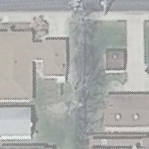
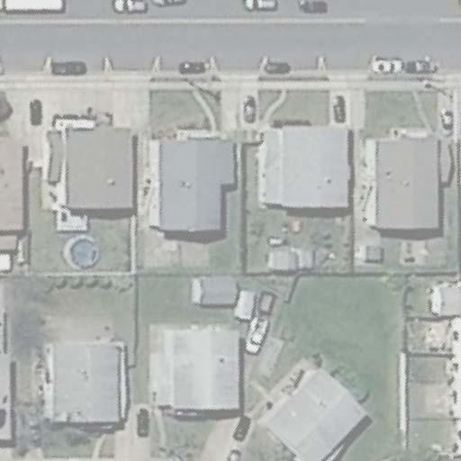
4 1,285 (2010) 107 (2010) 5,964 (2014) 3,759 (2013) 550 (2012) 4,129 (2013) 7,407 (2011) 8,596 (2013) 11,932 (2011) MON 29 LVD 563 VENTNOR EGG HARBOR JEROME AVE 563 ESSEX AVE MARGATE LAFAYETE AVE FREDRICKSBURG AVE AMHERST AMHERST AVE AVE MONMOUTH MONMOUTH AVE AVE MONMOUTH MONMOUTH AVE AVE QUINCY AVE WINCHESTER AVE AVE WINCHESTER AVE WASHINGTON AVE 36TH AVE LONGPORT VENTNOR AVE 2,264 (2011) ATLANTIC AVE 629 ATLANTIC AVE SPEED LIMIT SPEED SPEED LIMIT SPEED LIMIT ATLANTIC AVE LIMIT 30 SPEED LIMIT SPEED LIMIT MON 29 MARGATE BLVD 563 VENTNOR EGG HARBOR JEROME AVE 563 ESSEX AVE MARGATE LAFAYETE AVE FREDRICKSBURG AVE MONMOUTH MONMOUTH AVE AVE AMHERST AMHERST AVE AVE MONMOUTH MONMOUTH AVE AVE QUINCY AVE WINCHESTER AVE AVE WINCHESTER AVE WASHINGTON AVE 36TH AVE LONGPORT VENTNOR AVE 629 ATLANTIC AVE EXISTING CONDITIONS DATA SOURCES: Ventnor Avenue Signal Project (July 2015) Margate/Ventnor Police Departments NJDOT, NJ Transit, other public sources Site investigations INVENTORY: Street Widths Posted Speed Limits Traffic Signals One-way Streets Transit Service / Bus Stops Traffic & Pedestrian Volumes
 Pedestrian Bicycle Total")

» Dorset Ave: 21")
5 BICYCLE & PEDESTRIAN CRASH ANALYSIS Crash Summary ( ) Pedestrian Bicycle Total Ventnor Margate Total Crashes are concentrated along major routes:» Ventnor Ave: 85 crashes (33%)» Atlantic Ave: 57 crashes (22%)» Dorset Ave: 21 crashes (8%)
 SURREY AVE AVE Pedestrian (#) Boardwalk (#) Incapacitated Fatal")
 Boardwalk Crashes: Ventnor PD (2010-2015) GG HARBOR")
 2 36TH AVE MONMOUTH AVE WASHINGTON AVE VE AMHERST AVE AT")
6 DOR DOR LONGPORT CRASH CLUSTERS IN VENTNOR DORSET A Legend Bicycle (#) BALFOUR AVE CRASHES (8%) SURREY AVE AVE Pedestrian (#) Boardwalk (#) Incapacitated Fatal Crash Intersection Crash Corridor MONMOUTH AVE 14 CRASHES (5%) 3 4 Sources: Bike/Ped Crashes: Plan 4 Safety ( ) Boardwalk Crashes: Ventnor PD ( ) GG HARBOR Intersections/Corridors: SJTPO ( ) CRASHES (12%) CRASHES (4%) 2 36TH AVE MONMOUTH AVE WASHINGTON AVE VE AMHERST AVE AT ATLANTIC AVE

 Pedestrian")
 Boardwalk Crashes: Ventnor PD (2010-2015)")

7 MARSHALL AVE VENT BALFOUR AVE ESSEX AVE 3 MONMOUTH AVE AVE WINCHESTER WINCHESTER AVE AVE WELLINGTON AVE MARGATE ATLANTIC AVE OUTH OUTH AVE AVE AMHERST AMHERST AVE AVE QUINCY AVE 2 WASHINGTON AVE LAFAYETE AVE CRASH CLUSTERS IN MARGATE WINCHESTER AVE MONMOUTH AVE FREDRICKSBURG AVE VENTNOR AVE ESSEX AVE MARGATE BLVD Legend Bicycle (#) Pedestrian (#) Boardwalk (#) Incapacitated Fatal GG HARBOR Crash Intersection Crash Corridor Sources: Bike/Ped Crashes: Plan 4 Safety ( ) Boardwalk Crashes: Ventnor PD ( ) Intersections/Corridors: SJTPO ( ) JEROME AVE 10 CRASHES (4%) MARGATE AMHERST AVE MONMOUTH AVE MONMOUTH AVE QUINCY AVE WINCHESTER AVE WASHINGTON AVE 36TH AVE ATLANTIC AVE VENTNOR 15 CRASHES (6%) 13 CRASHES (5%) LONGPORT
» Approx.")
» Road diet for Atlantic Ave (4 in favor, 2 against)»")
» Traffic signal improvements on Atlantic Ave (3)» Support bike lanes")
8 SUMMARY OF PUBLIC MEETING #1 Margate Public Meeting (3/29)» Approx. 90 attendees» 17 written comments Ventnor Public Meeting (3/30)» Approx. 36 attendees» 6 written comments Common Themes: (36 total comments, 13 from website)» Improve pedestrian conditions/safety on Atlantic Ave (7)» Road diet for Atlantic Ave (4 in favor, 2 against)» Don t remove parking on Atlantic Ave (5)» Lower speed limit on Atlantic Ave (4)» More enforcement for biking, walking, and driving (4)» Traffic signal improvements on Atlantic Ave (3)» Support bike lanes on Monmouth/Winchester (2)» Explore options for a beach path in Margate (2)

9 PROJECT WEBSITE ventnor-margate.com INPUT TO-DATE: 276 Map Points 119 Written Comments PROBLEM AREA POINTS (115) 60 Atlantic Ave 19 Ventnor Ave 10 Ventnor Ave
10 PLAN ELEMENTS Pedestrian Network Plan Bicycle Network Plan Major Travel Routes Safe Routes to School Policy & Program Recommendations

11 BALFOUR BALFOUR AVE AVE SURREY AVE AVE DORSET DORSET AVE AVE EDGEWATER EDGEWATER AVE AVE GRANVILLE LE AVE WASHINGTON WA WA AVE WYOMING W AVE NEW HAVEN EN AVE CORNWALL AVE SUFFOLK AVE VASSAR SQ SQUARE 629 PEDESTRIAN NETWORK PLAN Commercial Nodes Park / Open Space MARGATE BLVD Legend Existing Traffic Signal Corridor-wide Signal Upgrades & Intersection Improvements Wider Beach Access Ramps Location-specific Un-signalized Intersection Improvements (12) New Marked Crosswalk (6) Schools Other Destinations New Traffic Signal or Beacon (2) New Sidewalk MONMOUTH MONMOUTH AVE AVE MONMOUTH AVE PACIFIC PACIFIC AVE AVE AMHERST AMHERST AVE AVE LAGOON LAGOON DR DR WELLINGTON AVE JEROME AVE HUNTINGTON AVE * Implement additional multi-way stop control on Monmouth & Winchester Avenues LAFAYETE AVE CLERMONT AVE DELAVAN AVE FREDRICKSBURG AVE WINCHESTER WINCHESTER AVE AVE WINCHESTER AVE WINCHESTER AVE OSBOURNE AVE WASHINGTON AVE MADISON AVE 36TH AVE VENTNOR AVE VENTNOR AVE ATLANTIC AN TIC CA AVE ATLANTIC AVE I ATLANTIC AVE AVE VENTNOR & MARGATE BICYCLE & PEDESTRIAN PLAN Steering Committee Meeting #3 --- DRAFT

 Curb extensions at major")


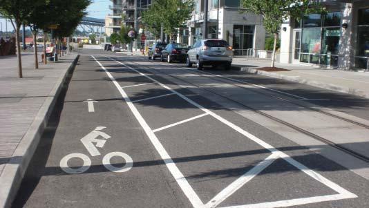
12 CORRIDOR-WIDE INTERSECTION IMPROVEMENTS Strategies to slow traffic, improve visibility, and enhance business environment: Consistent crosswalk striping (high-visibility or textured) Curb extensions at major crossing locations Daylighting of intersections Flexible Bollards (source: Textured Crosswalk Curb Extensions with Landscaping (source: Flexible Bollards with Bike Parking (source:

 Pedestrian Hybrid")
")

13 UN-SIGNALIZED CROSSWALK TREATMENTS Potential Treatments: Pedestrian Warning Signs In-Street Pedestrian Crossing Signs Rectangular Rapid Flashing Beacons (RRFBs) Pedestrian Hybrid Beacons (PHBs) In-Roadway Lighting (IRWL) Pedestrian Hybrid Beacon (source: KXAN, Texas) Pedestrian Warning Signs Rectangular Rapid Flashing Beacon (source: In-Roadway Lighting (IRWL)


14 BALFOUR BALFOUR AVE AVE SURREY AVE AVE DORSET DORSET AVE AVE EDGEWATER EDGEWATER AVE AVE GRANVILLE GRANVILLE AVE AVE WASHINGTON WASHINGTON AVE AVE WYOMING WYOMING AVE AVE NEW NEW HAVEN HAVEN AVE AVE CORNWALL CORNWALL AVE AVE SUFFOLK SUFFOLK AVE AVE VASSAR VASSAR SQUARE SQUARE 629 BICYCLE NETWORK PLAN Legend Shared Lane Markings Bicycle Lanes Shared Use Path One-way Conversion Commercial Nodes Park / Open Space Wider Beach Access Ramps Schools Other Destinations MARGATE BLVD One-way (existing) Bicycle Lane (existing) 563 MONMOUTH MONMOUTH AVE AVE MONMOUTH AVE PACIFIC PACIFIC AVE AVE AMHERST AMHERST AVE AVE LAGOON LAGOON DR DR WELLINGTON AVE JEROME AVE LAFAYETE AVE CLERMONT AVE DELAVAN AVE HUNTINGTON AVE FREDRICKSBURG AVE WINCHESTER WINCHESTER AVE AVE WINCHESTER AVE WINCHESTER AVE VENTNOR AVE VENTNOR AVE OSBOURNE AVE WASHINGTON AVE MADISON AVE 36TH AVE ATLANTIC AVE ATLANTIC AVE ATLANTIC AVE AVE VENTNOR & MARGATE BICYCLE & PEDESTRIAN PLAN Steering Committee Meeting #3 --- DRAFT

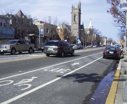
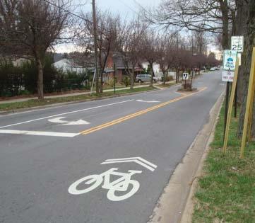
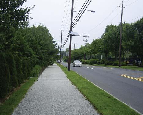
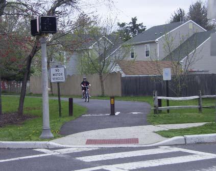
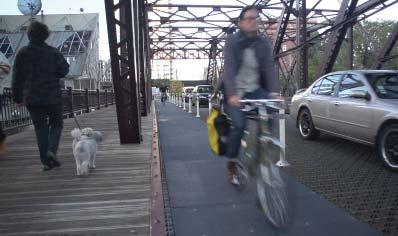
15 BICYCLE FACILITIES Shared Lane Markings Bicycle Lanes Shared Use Paths

16 MAJOR TRAVEL ROUTES Boardwalk / Beach Path Atlantic Avenue Ventnor Avenue Jerome Avenue
 24 hours/day PEAK (6/30 to LD) OFF-PEAK (LD to 6/30) VENTNOR 6 AM to 12 PM (Weekend) Daylight Hours (Weekday) Daylight Hours ALBANY ATLANTIC CITY PEAK 6 AM to 10 AM (5/15 to 10/15) OFF-PEAK")
17 PERMITTED BIKING HOURS ON BOARDWALK JACKSON ATLANTIC CITY PEAK (5/15 to 10/15) 6 AM to 10 AM OFF-PEAK (10/15 to 5/15) 24 hours/day ATLANTIC CITY PEAK (5/15 to 10/15) 6 AM to 10 AM OFF-PEAK (10/15 to 5/15) 24 hours/day PEAK (6/30 to LD) OFF-PEAK (LD to 6/30) VENTNOR 6 AM to 12 PM (Weekend) Daylight Hours (Weekday) Daylight Hours ALBANY ATLANTIC CITY PEAK 6 AM to 10 AM (5/15 to 10/15) OFF-PEAK Before 12 PM (10/15 to 5/15) After 4 PM CONNECTICUT
18 VENTNOR BOARDWALK RECOMMENDATIONS Expand hours to include dark periods (coordinate with Atlantic City) VENTNOR VENTNOR PEAK (6/30 to LD) 6 AM to 12 PM (Weekend) Daylight Hours (Weekday) PEAK (6/30 to LD) 6 AM to 12 PM (Weekend) All Hours (Weekday) OFF-PEAK (LD to 6/30) Daylight Hours OFF-PEAK (LD to 6/30) All Hours Advisory signs to reinforce boardwalk as a recreational bike route:» Slow speeds» Passing on left (using audible devices)» Yield to pedestrians


19 MARGATE BEACH PATH OPTIONS SEA BRIGHT, NJ VENICE BEACH, CA NORTH WILDWOOD, NJ NEW BRUNSWICK, NJ


20 ATLANTIC AVENUE - EXISTING CONDITIONS KEY ISSUES: Crash history / speeding Conditions at signalized intersections Multi-lane un-signalized crossings Incomplete bicycle network Dooring incidents in Margate bike lanes RECOMMENDED STRATEGIES: Traffic signal synchronization Traffic calming / lowering speed limit Pedestrian improvements Continuous bike lanes

 Margate")
21 ATLANTIC AVENUE - TRAFFIC SIGNALS Immediate/Low-Cost Strategies: Modify signal timings to provide enough time for pedestrians to cross at 3.5 ft/sec Install GPS-based clocks to coordinate signals and maintain a mph traffic flow Ventnor Signals 18 of 43 intersections are signalized Multisonic 820A controllers Likely compatible (Ventnor Ave project) Margate Signals 14 of 42 intersections are signalized PEEK and Econolite Controllers Likely compatible
22 ATLANTIC AVENUE - CORRIDOR OPTIONS Overall Strategy: Address bicycle & pedestrian needs comprehensively along the Atlantic Avenue corridor and balance with parking, traffic, and other needs 4-Lane Section Buffered Bike Lanes 3-Lane Section Buffered Bike Lanes + Pedestrian Refuge Separated Bikeway + Pedestrian Refuge
 at major un-signalized crossings To Beach Atlantic")
23 4-LANE SECTION W/ BIKE LANES Reduce travel lane widths from 12 to 10 to create space for Buffered Bike Lanes Limited improvements for pedestrians - evaluate additional crossing treatments (RRFBs, PHBs, signals) at major un-signalized crossings To Beach Atlantic Avenue


24 Atlantic t Avenue 4-Lane w/ Bike Lanes SPEED LIMIT 25 ATLANTIC AVENUE TWO-WAY TWO-WAY

25 3-LANE SECTION W/ BIKE LANES + PEDESTRIAN REFUGE Buffered Bike Lanes in each direction Center lane can be used as pedestrian refuge at One-Way/Southbound streets Provides speed management/traffic calming benefit May provide opportunity to reduce traffic signals along Atlantic Ave To Beach Atlantic Avenue
26 Atlantic Avenuee 3-Lane w/ Bike Lanes * Example with traffic signal located at side streets with NB one-way ATLANTIC AVENUE SPEED LIMIT 25 Pedestrian Refuge TWO-WAY TWO-WAY
27 Atlantic Avenuee 3-Lane w/ Bike Lanes * Example with traffic signal located at side streets with SB one-way SPEED LIMIT 25 ATLANTIC AVENUE TWO-WAY TWO-WAY

28 3-LANE SECTION W/ SEPARATED BIKEWAY + PEDESTRIAN REFUGE Two-way Separated Bikeway on beach side Center lane can be used as pedestrian refuge at One-Way/Southbound streets Provides speed management/traffic calming benefit May provide opportunity to reduce traffic signals along Atlantic Ave To Beach Atlantic Avenue


29 Atlantic t Avenue 3-Lane w/ Separated a Bikeway ATLANTIC AVENUE SPEED LIMIT 25 With driveways Without driveways TWO-WAY TWO-WAY


30 ATLANTIC AVE NEAR LUCY/GREENHOUSE Painted/textured intersection ATLANTIC AVE Head-in Parking Shared/curbless street with distinctive surface LUCY THE ELEPHANT DECATUR AVE Major access ramp to beach


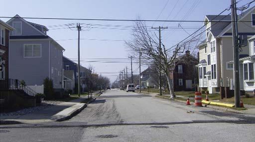
31 VENTNOR AVENUE - EXISTING CONDITIONS KEY ISSUES: Several crash clusters Long crossing distances (54 ) at uncontrolled crosswalks No provision for bike travel Bike parking is needed in business districts - but little space for it RECOMMENDED STRATEGIES: High-visibility or textured crosswalks Curb extensions in business districts: - Shorten pedestrian crossings - Provide space for bicycle parking Buffered bike lanes

32 VENTNOR AVENUE (CR 629) Existing Modified Section Buffered Bike Lanes + Curb Extensions


33 VENTNOR AVENUE NEAR DORSET AVENUE RECOMMENDATIONS: Remove 2nd EB lane Allow parking in EB direction Install marked crosswalks w/ refuge islands DORSET AVE VENTNOR AVE


34 DORSET AVENUE BRIDGE AREA P P Bicyce lanes with parking-side buffer Major travel corridor for Ventnor schools Curb extensions to improve visibility N. DERBY AVE EDGEWATER AVE Painted/textured intersection to serve as traffic calming feature and gateway Trim bushes and cut guard rail back DORSET AVENUE (CR 629) Apply bikeable surface over open bridge grate


35 JEROME AVENUE - EXISTING CONDITIONS KEY ISSUES: High-speed, multi-lane roadway section with no bike accommodation Long pedestrian crossings at uncontrolled locations near major activity generators: - Katz JCC / parking lots - Fremont Ave / park entrance RECOMMENDED STRATEGIES: Traffic calming/curb extensions 3-lane cross section w/ buffered bike lanes

36 JEROME AVENUE (CR 563) Existing 3-Lane Section Buffered Bike Lanes + Pedestrian Refuge


37 MONMOUTH AVE WINCHESTER AVE 629 WALKING & BIKING ROUTES TO SCHOOLS Ventnor/Margate Safe Routes to School Infrastructure Improvement Plan DRAFT LEGEND LAFAYETTE AVE WYOMING/VENTNOR GARDENS VENTNOR MARGATE JEROME AVE LAFAYETE AVE HUNTINGTON AVE DOUGLAS AVE 563 FULTON/HUNTING N GTON Ventnor Educational Community Complex FREDRICKSBURG AVE AMHERST/H ERST/HUNTINGTON TINGTON AMHERST/GLADSTONE S MONMOUTH AVE AVE WINCHESTER WINCHESTER AVE AVE Ross ES Tighe MS Major School Travel Corridor Minor School Travel Corridor Pedestrian Intersection Improvements Proposed Bicycle Lanes Proposed Shared Lane Markings VENTNOR AVE 629

38 BUFFERED BIKE LANES ON MONMOUTH/WINCHESTER AVENUES Existing With Buffered Bike Lanes


39 FULTON/N. HUNTINGTON CONCEPT PLAN SEASIDE CT N. HUNTINGTON AVE Add median island to shorten crossing and organize/slow traffic Painted/textured intersection to serve as traffic calming feature FULTON AVE Extend curbline to reduce crossing distances Minor travel corridor for Margate schools TO FIELDS COLMAR CIRCLE


40 AMHERST/GLADSTONE CONCEPT PLAN COLMAR CIRCLE GLADSTONE AVE Add median island to shorten crossing and control/slow traffic Painted/textured intersection to serve as traffic calming feature AMHERST AVE Major travel corridor for Margate schools GLADSTONE AVE


41 LAFAYETTE AVENUE IMPROVEMENTS Ventnor Educational Community Complex BALFOUR AVE Relocate crosswalk to align with sidewalk and add pedestrian refuge island Modify 60 wide cross-section to include bike lanes and a center turn Add new high-visibility crosswalk with pedestrian refuge island Straighten crosswalk and add pedestrian refuge island BIKE LANE LAFAYETTE AVE CENTER TURN LANE BIKE LANE BALFOUR AVE Add curb extensions to shorten crossing, calm traffic, and improve visibility ESSEX COURT Add curb extensions to shorten crossing, calm traffic, and improve visibility FULTON AVE


42 Wyoming/Ventnor Gardens Intersection Concept Plan N. ROSBOROUGH AVE Extend curbline to reduce size of intersection while still accommodating all turns Extend curbline to reduce speed of turning vehicles and shorten crossings VENTNOR GARDENS PLAZA Add high-visibility crosswalks on all approaches Add curb extensions to shorten crossing & improve visibility Major travel corridor for Ventnor Schools Shared Lane Markings WYOMING AVE 5/19/16 DRAFT
43 BALFOUR BALFOUR AVE AVE SURREY AVE AVE DORSET DORSET AVE AVE EDGEWATER EDGEWATER AVE AVE GRANVILLE GRANVILLE AVE AVE WASHINGTON WASHINGTON AVE AVE WYOMING WYOMING AVE AVE NEW NEW HAVEN HAVEN AVE AVE CORNWALL CORNWALL AVE AVE SUFFOLK SUFFOLK AVE AVE VASSAR VASSAR SQUARE SQUARE 629 BICYCLE PARKING PLAN Bike Parking Locations Commercial Nodes Park / Open Space MARGATE BLVD A. Amherst Ave Commercial B. Madison-Decatur Commercial C. Decatur Ave Beach Access D. Osbourne Ave Beach Access E. Jerome Avenue Park F. Lancaster-Jerome Commercial G. Margate Library Beach Access H. Granville-Frontenac Commercial I. Delavan Ave Beach Access J. Fredericksburg-Washington Commercial K. Washington Ave Beach Access L. Wyoming Ave Beach Access M. Ventnor Library Beach Access N. New Haven-Sacramento Commercial O. Cornwall Ave Beach Access P. Suffolk Ave Beach Access Q. Little Rock-Frankfort Commercial R. Dorset Ave Commercial S. Surrey Ave Recreational Area T. Dorset Ave Boat Launch U. Vassar Square Beach Access Wider Beach Access Ramps Schools Other Destinations T 563 MONMOUTH MONMOUTH AVE AVE MONMOUTH AVE PACIFIC PACIFIC AVE AVE AMHERST AMHERST AVE AVE LAGOON LAGOON DR DR WELLINGTON AVE JEROME AVE HUNTINGTON AVE 629 LAFAYETE AVE CLERMONT AVE DELAVAN AVE FREDRICKSBURG AVE WINCHESTER WINCHESTER AVE AVE WINCHESTER AVE WINCHESTER AVE OSBOURNE AVE WASHINGTON AVE MADISON AVE 36TH AVE VENTNOR AVE VENTNOR AVE A F B H J 629 ATLANTIC AVE ATLANTIC AVE N R Q ATLANTIC AVE AVE C D E G I K L M O P U S VENTNOR & MARGATE BICYCLE & PEDESTRIAN PLAN Steering Committee Meeting #3 --- DRAFT
 Inverted U-Racks")


 TOAST One rack element holds")

44 BICYCLE PARKING OPTIONS Inverted U-Racks (Individual) Inverted U-Racks (Grouped) Post & Loop Racks Specialty Bike Racks Specialty Bike Corrals INVERTED U One rack element supports two bikes. A One rack element supports two bikes. POST AND LOOP One rack element supports two bikes. COMB One rack element is a vertical segment of the rack. WAVE One rack element is a vertical segment of the rack. (see additional discussion on page 3) TOAST One rack element holds one wheel of a bike. Source: Bicycle Coalition of Greater Philadelphia
45 POLICY & PROGRAM RECOMMENDATIONS Local Ordinance Review Education Strategies Enforcement Strategies Bike Share for Absecon Island
 If a bike path is located adjacent to the road, bicycles must use the path and not the road (REMOVE) People riding bikes on roadways must ride in single file (REMOVE) Governors strip")
46 LOCAL ORDINANCE REVIEW Margate All bicycles owned by Margate residents must be inspected and registered (REMOVE) Ventnor All bicycles owned by Ventnor residents must be inspected and registered (REMOVE) If a bike path is located adjacent to the road, bicycles must use the path and not the road (REMOVE) People riding bikes on roadways must ride in single file (REMOVE) Governors strip (buffer) for street trees shall be minimum 3 wide (INCREASE TO 5 ) Obstructions within public Right-of-Way are regulated and may exclude bike racks (MODIFY) Example: Bicycle parking within the public right-of-way shall be located so as not to block the pedestrian path on a sidewalk or within a site. A minimum of 5 of unobstructed passage is required on public sidewalks. All bike racks shall be located at least 24 inches in all directions from a wall, door, landscaping, or other obstruction that would render use of the racks difficult or impractical.

47 EDUCATION STRATEGIES STREETSMART Pedestrian Safety Program (NJTPA)

48 ENFORCEMENT STRATEGIES Pedestrian Safety Enforcement (PSE) Program Sponsored by NJDHTS Training and support for local police officers Driver knowledge of law and yielding behavior

49 BIKE SHARE SYSTEM FOR ABSECON ISLAND Physical Characteristics:» Service Area» Station Density/Siting Business Model:» Jurisiction Owned/Managed» Non-Profit Business» For Profit Business Other Considerations:» Year-round vs. Seasonal» Program Marketing
50 NEXT STEPS Public Meeting #2 Develop Draft/Final Report
51 VENTNOR MARGATE BICYCLE & PEDESTRIAN PLAN
Margate City School District School Travel Plan
 Margate City School District School Travel Plan Prepared by: Cross County Connection Transportation Management Association June 2015 Cross County Connection Transportation Management Association was formally
City of Albert Lea Policy and Procedure Manual 4.10 ALBERT LEA CROSSWALK POLICY
 4.10 ALBERT LEA CROSSWALK POLICY PURPOSE: Pedestrian crosswalks are an integral part of our transportation infrastructure. To be effective and promote safety, marked crosswalks must be installed after
» Draft Recommendations» Discussion» Next Steps. Plan for Walking and Biking
 SAC Meeting Plan #3 for September Walking and 12, Biking 2018 » Draft Recommendations» Discussion» Next Steps Plan for Walking and Biking » Stakeholder and Public Outreach» Background data collection and
If a person walks within this focus area, these are examples of the places he or she could walk to or from:
 Portland Hillsdale Hillsdale Portland The Hillsdale focus area is located in the City of Portland. It is situated approximately three miles from the City of Portland s downtown, 5.5 miles from the City
The DC Pedestrian Master Plan
 The DC Pedestrian Master Plan September 28, 2010 George Branyan Pedestrian Program Coordinator District Department of Transportation Presentation Agenda Scope of the Plan Methodology Recommendations Implementation
Transportation Planning Division
 Transportation Planning Division Presentation Outline Study Tasks Recap of Previous Meetings Data Collected Focus Areas within Study Limits Design Principles Tool Box Recommended Concepts Schedule Moving
Designing for Pedestrian Safety in Washington, DC
 Designing for Pedestrian Safety in Washington, DC February 25, 2014 George Branyan Pedestrian Program Coordinator District Department of Transportation DC Journey to work mode split: 2012 Means of Transportation
NJDOT Complete Streets Checklist
 Background The New Jersey Department of Transportation s Complete Streets Policy promotes a comprehensive, integrated, connected multi-modal network by providing connections to bicycling and walking trip
Arlington Public Schools New Elementary School at Thomas Jefferson Site Off-Site Transportation. Thomas Jefferson BLPC / PFRC Meeting July 27, 2016
 Arlington Public Schools New Elementary School at Thomas Jefferson Site Off-Site Transportation Thomas Jefferson BLPC / PFRC Meeting July 27, 2016 1.Review of Analysis 2.Key Transportation Issues 3.Recommendations
Broad Street Bicycle Boulevard Design Guidelines
 Broad Street Bicycle Boulevard Design Guidelines Building from the strategies introduced in the 2013 Bicycle Transportation Plan and community input received thus far, City Transportation Staff have identified
Bicycle and Pedestrian Advisory Committee (BPAC) November 21, 2013
 November 21, 2013") Bicycle and Pedestrian Advisory Committee (BPAC) November 21, 2013 OVERALL LAND USE CONCEPT Overall Broadway Valdez District: 95.5 acres (35.1 acres right-of ways + 60.4 acres developable land) Plan Subareas:
Bicycle and Pedestrian Advisory Committee (BPAC) November 21, 2013 OVERALL LAND USE CONCEPT Overall Broadway Valdez District: 95.5 acres (35.1 acres right-of ways + 60.4 acres developable land) Plan Subareas:
MONTCLAIR SAFE COMPLETE STREETS IMPLEMENTATION PLAN. Monday November 13, 2017 Michael Dannemiller, Principal Engineer NV5, Inc.
 MONTCLAIR SAFE COMPLETE STREETS IMPLEMENTATION PLAN Monday November 13, 2017 Michael Dannemiller, Principal Engineer NV5, Inc. PROJECT TEAM THE OFFICE OF BICYCLE AND PEDESTRIAN PROGRAMS, NEW JERSEY DEPARTMENT
US 278 Corridor Concept Presentation. Avondale Estates Intersection Improvement/Roundabout and Road Diet Feasibility Study March 19, 2015
 US 278 Corridor Concept Presentation Avondale Estates Intersection Improvement/Roundabout and Road Diet Feasibility Study March 19, 2015 Thanks to our Partners Atlanta Regional Commission Georgia Department
Dr. M.L. King, Jr. Street North Complete Streets Resurfacing Opportunities HOUSING, LAND USE, AND TRANSPORTATION COMMITTEE MARCH 22, 2018
 Dr. M.L. King, Jr. Street North Complete Streets Resurfacing Opportunities HOUSING, LAND USE, AND TRANSPORTATION COMMITTEE MARCH 22, 2018 What s Happening The City plans to mill and resurface Dr. M.L.
Watertown Complete Streets Prioritization Plan. Public Meeting #1 December 14, 2017
 Watertown Complete Streets Prioritization Plan Public Meeting #1 December 14, 2017 Goals for Public Meeting Overview of MassDOT Complete Streets Funding Program Educate the community on Complete Streets
Road Diets FDOT Process
 Florida Department of TRANSPORTATION Road Diets FDOT Process Humberto Castillero, PE, PTOE Roadway Design Office Purpose of Guide Develop a statewide lane elimination review process Balance state & local
Agenda. Overview PRINCE GEORGE S PLAZA METRO AREA PEDESTRIAN PLAN
 PRINCE GEORGE S PLAZA METRO AREA PEDESTRIAN PLAN May 28, 2008 Agenda Welcome and introductions Project overview and issue identification Planning context and strengths Design challenges and initial recommendations
BETHEL ROAD AND SEDGWICK ROAD CORRIDOR STUDY
 DRAFT PLAN City Council Meeting August 14, 2017 STUDY AREA Sedgwick Corridor State Route 160, principal arterial with Class 3 access management designation, commuter and freight route, connection to SR
Washington County SW Beaverton-Hillsdale Hwy. & SW Scholls Ferry Rd.
 Washington County SW Beaverton-Hillsdale Hwy. & SW Scholls Ferry Rd. SW Beaverton-Hillsdale Hwy. & SW Scholls Ferry Rd. Washington County The SW Beaverton-Hillsdale Hwy & SW Scholls Ferry Rd. focus area
Welcome and Introductions Overview of the Study to Date Community Involvement Intersection Improvement Concepts Bike-Ped Recommendations ITS
 Welcome and Introductions Overview of the Study to Date Community Involvement Intersection Improvement Concepts Bike-Ped Recommendations ITS Recommendations Transit Recommendations Next Steps Inventoried
COMMUNITY MEETING AGENDA
 COMMUNITY MEETING AGENDA Welcome and Introductions SAFE Presentation Project Presentation Priorities Feedback Next Steps Q&A Santa Cruz Avenue Corridor Study 1 Santa Cruz Avenue Corridor Study Community
Draft North Industrial Area-Wide Traffic Plan
 Summary of North Industrial and Hudson Bay Industrial Recommended Improvements Table 1. Summary of s Item Location 1 2 3 4 5 6 7 8 9 10 11 12 Millar Ave north of 51st St Super 8 Motel back lane 400 Block
Pine Hills Road Pedestrian/Bicycle Safety Study Board of County Commissioners Work Session
 Pine Hills Road Pedestrian/Bicycle Safety Study Board of County Commissioners Work Session February 20, 2018 Meeting Agenda Study Overview Existing Conditions Access Management Potential Gateway Features
Omaha s Complete Streets Policy
 Omaha s Complete Streets Policy (Adopted August 2015) VISION To create great places and enhance our quality of life, the City of Omaha will provide safe, accessible streets for all users. Complete Streets
City of Davis East Covell Corridor Plan
 Community Open House #2 January 22, 2014 6:00 8:00 p.m. Veterans Memorial Center, Club Room City of Davis Introduction The (ECCP) is a taking a comprehensive look at the existing transportation systems
CONNECTIVITY PLAN. Adopted December 5, 2017 City of Virginia Beach
 CONNECTIVITY PLAN Adopted December 5, 2017 City of Virginia Beach CONTENTS 1.0 Background & Purpose... 2 2.0 Existing Inventory & Analysis... 3 ViBe District Existing Walking Conditions... 4 3.0 ViBe District
Brooklyn Boulevard (County Road 152) Reconstruction Project Phase I. OPEN HOUSE June 20, 2017
 Reconstruction Project Phase I. OPEN HOUSE June 20, 2017") Brooklyn Boulevard (County Road 152) Reconstruction Project Phase I OPEN HOUSE June 20, 2017 Brooklyn Boulevard (County Road 152) Phase I Project Partners Project Lead Other Project Partners include Brooklyn
Brooklyn Boulevard (County Road 152) Reconstruction Project Phase I OPEN HOUSE June 20, 2017 Brooklyn Boulevard (County Road 152) Phase I Project Partners Project Lead Other Project Partners include Brooklyn
SAFE ROUTES TO SCHOOL
 SAFE ROUTES TO SCHOOL Forest Ridge Elementary School Existing Conditions and ACTION PLAN > Oak Creek - Franklin Joint School District Table of Contents CONTEXT Enrollment Boundaries
PRINCE GEORGE S PLAZA METRO AREA PEDESTRIAN PLAN
 PRINCE GEORGE S PLAZA METRO AREA PEDESTRIAN PLAN May 28, 2008 Agenda Welcome and introductions Project overview and issue identification Planning context and strengths Design challenges and initial recommendations
ROUTE 81 CORRIDOR STUDY DESIGN CONCEPTS
 RT 81 Corridor Study CLINTON ROUTE 81 CORRIDOR STUDY DESIGN CONCEPTS View north on High Street, with potential improvements to the streetscape Draft Recommendations November 8 th, 2018 TOWN OF CLINTON
APPENDIX A: Complete Streets Checklist DRAFT NOVEMBER 2016
 APPENDIX A: Complete Streets Checklist DRAFT NOVEMBER 2016 Complete Streets Checklist MetroPlan Orlando s Complete Streets Checklist is an internal planning tool for staff to further implementation of
EXECUTIVE SUMMARY. Vision
 Vision Walking and bicycling in Salt Lake City will be safe, convenient, comfortable, and viable transportation options that connect people to places, foster recreational and economic development opportunities,
Water Street Promenade Engineering and Design Services
 Preliminary Design Presentation Parking & Traffic Safety Committee Water Street Promenade Engineering and Design Services July 16,2014 November 3, 2016 Education / Infrastructure / Innovation 1 Project
TRAFFIC ACTION PLAN. North Central Neighborhood CITY OF SAN MATEO
 TRAFFIC ACTION PLAN North Central Neighborhood CITY OF SAN MATEO Draft February 2017 Table of Contents Introduction... 1 The Traffic Forum Process... 4 Neighborhood Traffic Issues... 6 Neighborhood Recommendations
NEWMARKET UPHAM S CORNER
 SOUTH STATION Planning Initiative NEWMARKET UPHAM S CORNER COLUMBIA ROAD (P) FOUR CORNERS/GENEVA Working Advisory Group (WAG) Meeting #5 TALBOT AVENUE MORTON STREET BLUE HILL AVE/CUMMINS HWY (P) RIVER
C/CAG. Sunnybrae Elementary School Walking and Bicycling Audit. San Mateo-Foster City School District JUNE 2013
 Sunnybrae Elementary School Walking and Bicycling Audit JUNE 2013 San Mateo-Foster City School District C/CAG City/County Association of Governments of San Mateo County SUNNYBRAE ELEMENTARY SCHOOL WALKING
STATUS OF 2009 PEDESTRIAN MASTER PLAN (AS OF DECEMBER 2013)
") Appendix P.1 STATUS OF 2009 PEDESTRIAN MASTER PLAN (AS OF DECEMBER 2013) The 2009 Pedestrian Master Plan establishes 21 core recommendations in three goal areas to improve pedestrian transportation in
Appendix P.1 STATUS OF 2009 PEDESTRIAN MASTER PLAN (AS OF DECEMBER 2013) The 2009 Pedestrian Master Plan establishes 21 core recommendations in three goal areas to improve pedestrian transportation in
COWETA HIGH SCHOOL AND EAST HIGHWAY 51
 COWETA HIGH SCHOOL AND EAST HIGHWAY 51 Lack of sidewalks along Ben Lumpkin Rd. Lack of crosswalks and ramps at intersection. Hwy 51 is wide to cross as a pedestrian. No ADA compliance or connection to
Downtown Naples Mobility and Connectivity Study. Naples City Council Presentation January 2017
 Downtown Naples Mobility and Connectivity Study Naples City Council Presentation January 2017 Agenda 1. Introduction 2. Scope Review 3. Project Schedule 4. Existing Conditions 5. Public Charrette 6. Mobility
Pedestrian & Bicycle Safety Innovations & Applications
 Pedestrian & Bicycle Safety Innovations & Applications County Engineers Association of Maryland Spring, 2017 Conference May 25, 2017 George Branyan Pedestrian Program Coordinator District Department of
PEDESTRIAN SAFETY ASSESSMENT SR 934/NORMANDY DRIVE AND 71 Street
 PEDESTRIAN SAFETY ASSESSMENT SR 934/NORMANDY DRIVE AND 71 Street PRESENTED BY MISLEIDYS LEON TRAFFIC SAFETY PROGRAM ENGINEER FLORIDA DEPARTMENT OF TRANSPORTATION (FDOT) BACKGROUND In response to citizen
El Camino Real Specific Plan. TAC/CAC Meeting #2 Aug 1, 2018
 El Camino Real Specific Plan TAC/CAC Meeting #2 Aug 1, 2018 Land Use Alternatives Goals and Tradeoffs Parks & open space Housing Retail & services Civic spaces Parking Community gathering spaces 3 Alternatives
Bridgewater Complete Streets Prioritization Plan and Pedestrian Safety Assessment
 Bridgewater Complete Streets Prioritization Plan and Pedestrian Safety Assessment Presented by Luciano Rabito Manager of Complete Streets Presented to Bridgewater, MA Wednesday, April 26, 2017 6:30 P.M.
12/4/2016 VIA . RE: Grocery Outlet Del Paso (DR16-328)
") 12/4/2016 VIA EMAIL Ethan Meltzer, Assistant Planner City of Sacramento Community Development Department 300 Richards Blvd, 3 rd Floor Sacramento, CA 95811 RE: Grocery Outlet Del Paso (DR16-328) Dear Mr.
12/4/2016 VIA EMAIL Ethan Meltzer, Assistant Planner City of Sacramento Community Development Department 300 Richards Blvd, 3 rd Floor Sacramento, CA 95811 RE: Grocery Outlet Del Paso (DR16-328) Dear Mr.
Oakland Pedestrian Master Plan Oakland Pedestrian Plan Draft Recommendations Chapter Outline
 EISEN LETUNIC T R A N S P O R T A T I O N, ENVIRO N M E N TA L A N D URBAN PLANNIN G MEMORANDUM To Oakland Pedestrian Plan Technical Advisory Committee & Pedestrian Advisory Group From Victoria Eisen Date
City of Birmingham Draft Multi-modal Transportation Plan
 City of Birmingham Draft Multi-modal Transportation Plan City Commission Public Hearing Monday, November 25, 2013 7:30 pm Norman Cox, PLA, ASLA The Greenway Collaborative, Inc. Ann Arbor, Michigan The
Memo. Introduction. Memphis STP Pedestrian Sidewalk Project
 Memo Memphis STP Pedestrian Sidewalk Project To: Kyle Wagenshutz, City of Memphis From: Matthew Berkow, Collin Chesston, and Anne Eshleman, Alta Planning + Design Date: June 2014 Re: Photo Inventory Introduction
City of Vallejo Traffic Calming Toolbox
 City of Vallejo Traffic Calming Toolbox June 1, 2013 Final Table of Contents Introduction... 1 Non-Physical Devices... 3 High-Visibility Crosswalk... 3 In Pavement Lighted Crosswalk... 4 Rapid Flashing
Lynchburg District Update
 Lynchburg District Update Virginia Statewide Bicycle and Pedestrian Advisory Committee Spring Meeting May 16 th, 2017 David Cook Transportation Planner, VDOT Lynchburg District Table of Contents Active
Tonight is for you. Learn everything you can. Share all your ideas.
 Strathcona Neighbourhood Renewal Draft Concept Design Tonight is for you. Learn everything you can. Share all your ideas. What is Neighbourhood Renewal? Creating a design with you for your neighbourhood.
F L E T C H E R A V E N U E
 Jan. 29, 2014 Introduction F L E T C H E R A V E N U E FDOT Local Agency Program (LAP) Project FPN: 428214-1-58-01 CIP 63090 Hillsborough County, Traffic Engineering, PWD Stake holders and partners are
Traffic Improvements for the Transit Oriented Development District (TODD) Meriden Public Library March 11, 2014
 Meriden Public Library March 11, 2014") Traffic Improvements for the Transit Oriented Development District (TODD) Meriden Public Library March 11, 2014 Project Overview Coordinate roadway improvements with other major projects HUB Flood Control
Traffic Improvements for the Transit Oriented Development District (TODD) Meriden Public Library March 11, 2014 Project Overview Coordinate roadway improvements with other major projects HUB Flood Control
KEARNY MESA COMMUNITY PLAN UPDATE
 KEARNY MESA COMMUNITY PLAN UPDATE January 18, 2018 SUBCOMMITTEE MEETING Mobility Concepts and Urban Design Presentation Outline Mobility Concepts: Multimodal Planning Toolbox Presentation and Activities
PRESS RELEASE San Joaquin Council of Governments
 PRESS RELEASE San Joaquin Council of Governments For Immediate Release February 23, 2018 Contact: Nicole Gorham, 235-0582 gorham@sjcog.org SJCOG Board Awards $19.63 Million in Measure K Bicycle, Pedestrian,
Bicycle and Pedestrian Chapter TPP Update Overview. TAB September 20, 2017
 Bicycle and Pedestrian Chapter TPP Update Overview TAB September 20, 2017 Bicycling & Walking in the Twin Cities Where are we now? The Bike-Pedestrian system Current trends New developments Where are we
Fulton Market Streetscape
 Fulton Market Streetscape Ogden Avenue to Halsted Street Public Meeting Recommended Improvements December 10th, 2014 Meeting Purpose and Goals Present Existing Conditions Community Input and Charrette
9/21/2016 VIA . RE: The Knot (DR16-270)
") 9/21/2016 VIA EMAIL Garrett Norman, Assistant Planner City of Sacramento Community Development Department 300 Richards Boulevard, 3 rd Floor Sacramento, CA 95811 RE: The Knot (DR16-270) Dear Mr. Norman:
9/21/2016 VIA EMAIL Garrett Norman, Assistant Planner City of Sacramento Community Development Department 300 Richards Boulevard, 3 rd Floor Sacramento, CA 95811 RE: The Knot (DR16-270) Dear Mr. Norman:
Summary: Mercer County Princeton Avenue & Spruce Street Study January 2009
 Summary: Several recent studies have assessed potential development and redevelopment opportunities in the Mercer Crossing area of Trenton, Ewing, and Lawrence. This Princeton Avenue and Spruce Street
Corpus Christi Metropolitan Transportation Plan Fiscal Year Introduction:
 Introduction: The Safe, Accountable, Flexible, Efficient Transportation Equity Act: A Legacy for Users (SAFETEA-LU) has continued the efforts started through the Intermodal Surface Transportation Efficiency
7/23/2017 VIA . Michael Hanebutt City of Sacramento Community Development Department 300 Richards Boulevard, 3 rd Floor Sacramento, CA 95811
 7/23/2017 VIA EMAIL Michael Hanebutt City of Sacramento Community Development Department 300 Richards Boulevard, 3 rd Floor Sacramento, CA 95811 RE: 65 th Street Apartments (DR17-220) Dear Mr. Hanebutt:
Doing it Right: Leveraging Data and Evaluation to Develop Pedestrian Safety Projects
 Doing it Right: Leveraging Data and Evaluation to Develop Pedestrian Safety Projects 1 Safe Kids Overview 2 Our Mission We work to keep all kids safe from preventable injuries 3 Why It Matters 4 Where
Safe Routes to School: Munroe Elementary Walk Audit Report. Image: Drexel, Barrell & Co.
 Safe Routes to School: Munroe Elementary Walk Audit Report Image: Drexel, Barrell & Co. April 12, 2016 OVERVIEW As part of the 2014/2015 Denver Safe Routes to School (SRTS) Program, WalkDenver coordinated
About the study. North Milwaukee Ave. Key goals of this study are to: Achieve Vision Zero* by. Harmonize the space and improve walkability
 About the study Key goals of this study are to: North Milwaukee Avenue is a local and regional street for multiple modes of transportation. It is officially zoned and functions as a pedestrian street southeast
Toward Zero Deaths. Regional SHSP Road Show Meeting. Virginia Strategic Highway Safety Plan. presented by
 Toward Zero Deaths Regional SHSP Road Show Meeting presented by Virginia Strategic Highway Safety Plan December 1, 2016 1 Welcome & Introductions Purpose of the Meeting Objectives & Key Outcomes Agenda»
Community Transportation Plan
 Community Transportation Plan Appendix A: Traffic Calming CITY OF DECATUR COMMUNITY TRANSPORTATION PLAN Appendix A: City of Decatur City-wide Residential Traffic Calming Program Process & Procedures The
North Avenue Corridor Study
 North Avenue Corridor Study City Council October 6, 2014 Presentation Outline Project Initiation & Process Corridor Conditions & Issues Vision & Goals Concept Development - Development/Evaluation Implementation
Freeway ramp intersection study
 Freeway ramp intersection study Supporting Vision Zero: Zero traffic deaths in San Francisco by 2024 Study Goals: Primary Improve Safety Improve Accessibility Secondary Provide Efficient Circulation Accommodate
Arlington Public Schools Thomas Jefferson Site Evaluation Transportation Networks. Thomas Jefferson Working Group Meeting #6 November 10, 2014
 Arlington Public Schools Thomas Jefferson Site Evaluation Transportation Networks Thomas Jefferson Working Group Meeting #6 November 10, 2014 2 3 INTRODUCTION 4 Goal of our work: Identify and assess multi-modal
Ottawa Beach Road Study
 Ottawa Beach Road Study Prepared For: Park Township September 30, 2014 Project No. G140303 OTTAWA BEACH ROAD STUDY PREPARED FOR: PARK TOWNSHIP SEPTEMBER 30, 2014 PROJECT NO. G140303 TABLE OF CONTENTS 1.0
Station 1: Street & Sidewalk Upgrades
 Station 1: Street & Sidewalk Upgrades Existing no left turn; Potential left turn arrow, see Circulation Study boards for more information Thru-lane guidance Improved lead-in green bike lane 17TH ST CASTRO
Major Bike Routes 102 Avenue Workshop April 21, 2015
 Major Bike Routes 102 Avenue Workshop April 21, 2015 Our Purpose Today Provide context on how Major Bike Routes fit into Edmonton s future Share information on what we heard in our last phase, and how
SAFE ROUTES TO SCHOOL
 SAFE ROUTES TO SCHOOL Edgewood Elementary School Existing Conditions and ACTION PLAN > Oak Creek - Franklin Joint School District Table of Contents CONTEXT Enrollment Boundaries Enrollment
CITY OF COCOA BEACH 2025 COMPREHENSIVE PLAN. Section VIII Mobility Element Goals, Objectives, and Policies
 CITY OF COCOA BEACH 2025 COMPREHENSIVE PLAN Section VIII Mobility Element Goals, Objectives, and Policies Adopted August 6, 2015 by Ordinance No. 1591 VIII MOBILITY ELEMENT Table of Contents Page Number
6/14/2013 VIA . Evan Compton, Associate Planner Community Development Department City of Sacramento 300 Richards Blvd Sacramento, CA 95814
 6/14/2013 VIA EMAIL Evan Compton, Associate Planner Community Development Department City of Sacramento 300 Richards Blvd RE: Sacramento Natural Foods Co-Op (P13-025) Dear Mr. Compton: WALKSacramento appreciates
Dra Design and Land Use Op ons Booklet
 Dra Design and Land Use Op ons Booklet March, 2015 This page was inten onally le blank. 2 Commercial-Vista Corridor Plan This booklet summarizes the street design and land use alterna ves for the Commercial
Complete Streets Funding Program Project Prioritization Plan
 Funding Program Project Prioritization Plan Location and Type Needs South Street Crosswalk Installation Stripe a new formalized crosswalk across South Street at the Anne T. Dunphy School pedestrian path
Off-road Trails. Guidance
 Off-road Trails Off-road trails are shared use paths located on an independent alignment that provide two-way travel for people walking, bicycling, and other non-motorized users. Trails specifically along
Active Transportation Facility Glossary
 Active Transportation Facility Glossary This document defines different active transportation facilities and suggests appropriate corridor types. Click on a facility type to jump to its definition. Bike
Pedestrian Project List and Prioritization
 To: Kyle Wagenschutz, City of Memphis CC: From: Anne Conlon and John Cock, Alta Planning + Design Date: December, 2014 Re: Project List Development (Task 3.1-3.2) and Project List Prioritization (Task
Item to be Addressed Checklist Consideration YES NO N/A Required Description Complete Streets Guidelines
 Passaic County Complete Streets Checklist - Concept Development Project Name Item to be Addressed Checklist Consideration YES NO N/A Required Description Complete Streets Guidelines Existing Plans Have
Bicycle and Pedestrian Advisory Council May 15, 2015
 Bicycle and Pedestrian Advisory Council May 15, 2015 Updates Spring Bike/Ped counts took place Tuesday May 12 Thursday, May 14 40 volunteers and locations counted across the region More than double the
Ocean Park Boulevard Green Street Project Alternatives & Trade Offs
 Planning Commission March 4, 2009 Ocean Park Boulevard Green Street Project Alternatives & Trade Offs Purpose of Tonight s Meeting Review concept plans and options Provide input on alternatives and trade-offs
Outreach Approach RENEW SF served as the primary liaison with the North Beach community; the Chinatown. Executive Summary
 Executive Summary Executive Summary The Columbus Avenue Neighborhood Transportation Study s objective is to identify changes to transportation infrastructure and policies that could enhance the livability
MAG Town of Cave Creek Bike Study Task 6 Executive Summary and Regional Significance Report
 Page 1 MAG Town of Cave Creek Bike Study Task 6 Executive Summary and Regional Significance Report August 1, 2012 MAG Project #481 Page 2 Task 6 Executive Summary and Regional Significance Report Introduction
North Avenue Corridor Study
 North Avenue Corridor Study Advisory Committee Meeting #6 July 1, 2014 Agenda Concept Revisions based on Advisory Committee feedback Review of New Concept Scoring & Costs Concept Discussion/Questions Voting:
Board-Approved Funding Awards for Cycle 4 Active Transportation Grant Program Projects (in Order of Project Rankings) Approved on
 Approved on") CAPITAL Large Category Projects Board-Approved Funding Awards for Cycle 4 Active Transportation Grant Program Projects (in Order of Project Rankings) Approved on 07-27-18 1 La Mesa University Ave Pedestrian
CAPITAL Large Category Projects Board-Approved Funding Awards for Cycle 4 Active Transportation Grant Program Projects (in Order of Project Rankings) Approved on 07-27-18 1 La Mesa University Ave Pedestrian
Southview Blvd & 3 rd Avenue Improvement Project. Public Open House December 4, to 7pm
 Southview Blvd & 3 rd Avenue Improvement Project Public Open House December 4, 2014 5 to 7pm Southview Blvd & 3 rd Avenue Public Information Meeting Agenda Presentation 5:30 to 6:15 pm Purpose of Project
Closing Plenary Session
 TRAFFIC SAFETY CONFERENCE Closing Plenary Session June 9, 2017 Las Colinas, TX Order of Report Out June 9, 2017 Las Colinas, TX Distracted Driving Prioritized Countermeasures Countermeasure 4a Systemically
Appendix C. TRAFFIC CALMING PROGRAM TOOLBOX
 Appendix C. TRAFFIC CALMING PROGRAM TOOLBOX PHASE I...2 Do Not Enter Sign...3 One-Way Sign...4 Turn Prohibition...5 Pavement Markings...6 Speed Monitoring Trailer...7 Neighborhood Speed Watch...8 Police
HYATTSVILLE TRANSPORTATION PLAN. City Council Update March 19, 2018
 HYATTSVILLE TRANSPORTATION PLAN City Council Update March 19, 2018 AGENDA PROJECT GOALS DATA COLLECTION WHAT WE LEARNED NEXT STEPS PROJECT GOALS Identify bicycle and pedestrian needs of the city Evaluate
REGIONAL BICYCLE AND PEDESTRIAN DESIGN GUIDELINES
 REGIONAL BICYCLE AND PEDESTRIAN DESIGN GUIDELINES November 16, 2011 Deb Humphreys North Central Texas Council of Governments Bicycle and Pedestrian Advisory Committee Snapshot of the Guide 1. Introduction
2018 Pedestrian and Bicycle and Safe Routes to School Application for Funding Page 1 of 31
 2018 Pedestrian and Bicycle and Safe Routes to School Application for Funding Page 1 of 31 2018 Pedestrian and Bicycle and Safe Routes to School Application for Funding Part 1: General Information Funding
5. RUNNINGWAY GUIDELINES
 5. RUNNINGWAY GUIDELINES These guidelines should be considered collectively when making runningway decisions. A runningway is the linear component of the transit system that forms the right-of-way reserved
MARKET/JFK VISION ZERO PILOT PROJECT FEBRUARY 2019 EVALUATION REPORT
 MARKET/JFK VISION ZERO PILOT PROJECT FEBRUARY 2019 EVALUATION REPORT WHY IS THIS PROJECT IMPORTANT? Market Street and JFK Boulevard in Center City are key east-west corridors in the core business district.
6.4 RECOMMENDED IMPROVEMENTS
 6.4 RECOMMENDED IMPROVEMENTS 6.4.1 Williston Road Recommendations While all alternatives would be an improvement over existing conditions, Alternative 3B is recommended over the others because it provides
San Jose Transportation Policy
 San Jose Transportation Policy Protected Intersections in LOS Policies to Support Smart Growth Presented by: Manuel Pineda City of San Jose Department of Transportation Bay Area Map San Francisco Oakland
PEDESTRIAN CROSSING TREATMENTS
 PEDESTRIAN CROSSING TREATMENTS BEST PRACTICES Presented by: Doug Enderson, P.E., PTOE Cody Salo, P.E. 1 PRESENTER INTRODUCTIONS Doug Enderson, P.E., PTOE Ped Crossing Experience: ADA Design-Build ADA Inventory
FOCUS AREA 1 - Alberta Avenue Pocket Park 3 (121 Ave and 92 St)
") FOCUS AREA 1 - Alberta Avenue Pocket Park 3 (121 Ave and 92 St) New benches Plant evergreen trees Widen existing sidewalk from 1.5m to 1.8m Marked crosswalk 1.8m wide sidewalk Add pedestrian oriented lights
FOCUS AREA 1 - Alberta Avenue Pocket Park 3 (121 Ave and 92 St) New benches Plant evergreen trees Widen existing sidewalk from 1.5m to 1.8m Marked crosswalk 1.8m wide sidewalk Add pedestrian oriented lights
The Leadville Bikeway Design Recommendations DRAFT January 2018
 The Leadville Bikeway Design Recommendations DRAFT January 2018 Overview The Leadville Bikeway project aims to create a bikeway that is compatible with and adds value to the neighborhood and surrounding
Pedestrian Road Safety Audit
 Pedestrian Road Safety Audit Middlebrook Road From Father Hurley Boulevard to Waring Station Road December 2017 Montgomery County Department of Transportation Table of Contents 1. Introduction... 1 1.1