BOARD OF ADJUSTMENT AGENDA
|
|
|
- Sheryl Watts
- 5 years ago
- Views:
Transcription
1 BOARD OF ADJUSTMENT AGENDA Board of Adjustment Special Meeting - Tuesday, April 30, :00 p.m. City Hall - City Commission Chambers, 100 North U.S. #1, Fort Pierce, Florida 1. CALL TO ORDER 2. PRAYER and PLEDGE OF ALLEGIANCE 3. ROLL CALL 4. CONSIDERATION OF ABSENCES 5. CERTIFICATION OF ALTERNATE MEMBER(S) 6. NEW BUSINESS a. Variance Center State Bank Okeechobee Road 7. DISCUSSION / OTHER BUSINESS 8. ADJOURNMENT Any person seeking to appeal any decision by the Board of Adjustment with respect to any matter considered at this meeting is advised that a record of proceedings is required in any such appeal and that such person may need to insure that a verbatim record of the proceedings is made including the testimony and evidence upon which the appeal is to be based. Persons who require special accommodations under the Americans with Disabilities Act (ADA) should contact the Planning Department at (772) , at least five (5) days prior to the meeting. Persons who are hearing or speech impaired may use the Florida Relay System by dialing 711. April 30, 2015 Page 1
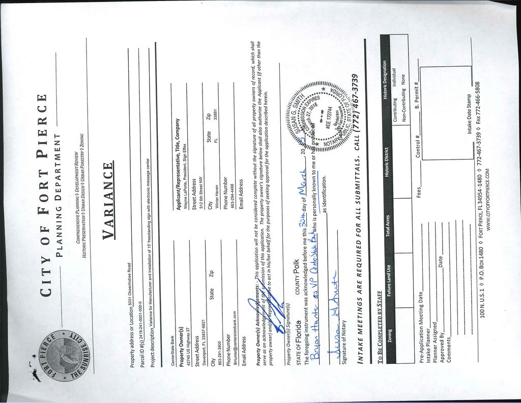
2 Planning Board of Adjustment Meeting Date: 04/30/2015 Information REQUESTED ACTION Variance Center State Bank Okeechobee Road LOCATION 5001 Okeechobee Road RESPONSIBLE STAFF Kori Benton, Historic Preservation Officer RECOMMENDATION Approval of a maximum overall sign height of thirteen (13) feet, and ninety-two (92) square feet in sign area. Attachments Staff Report Application Justification Statement & Supporting Documents Site Plan & Sign Location Sign Exhibit Form Review Form Started By: Kori Benton Final Approval Date: 04/24/2015 Started On: 04/17/ :42 PM

3 C I T Y O F F O R T P I E R C E P L A N N I N G D E P A R T M E N T REBECCA GROHALL, AICP, PLANNING MANAGER COMPREHENSIVE PLANNING DEVELOPMENT REVIEW HISTORIC PRESERVATION URBAN DESIGN URBAN FORESTRY ZONING TO: THROUGH: FROM: RE: Members of the City of Fort Pierce Board of Adjustment Rebecca Grohall, AICP, Planning Manager Kori Benton, Historic Preservation Officer Variance Exceed Allowable Sign Area & Height Center State Bank 5001 Okeechobee Road DATE: April 16, 2015 STAFF REPORT Owners/Applicants: Representative: Centerstate Bank of Florida NA US Highway 27 Davenport, FL Wayne LaPorte Sign Effex 512 6th Street NW Winter Haven, FL Requested Action: Approval of a variance to deviate from City Code Sections (5) a. 3.; to exceed the allowable sign area of an on-premise ground sign, and (b) (3)a.; to exceed the allowable sign height. The application proposes the construction of a 100 sq. ft. sign, fifteen (15) ft. in height. Location: 5001 Okeechobee Road Parcel ID: Zoning: Surrounding Zoning: Future Land Use: Parcel Size: C-3, General Commercial North East South West C-3 C-3 C-3 C-3 GC, General Commercial 1.23 acres 100 N. U.S. 1 P.O. BOX 1480 FORT PIERCE, FL FAX
4 P.O. BOX 1480 FORT PIERCE, FL PAGE 2 Staff Analysis: In accordance with Article VIII of Section 22 of the City Code, the applicant is requesting the Board of Adjustment app a potential conflict for visibility from east bound traffic, as presented in Exhibit A below: rove variances to deviate from City Code Sections (5) a. 3.; to exceed the allowable sign area of an onpremise ground sign, and (b) (3)a.; to exceed the allowable sign height for the same. The subject site is located at the southwest corner of Okeechobee Road and McNeil Road, home to the newly constructed Center State Bank branch location. The applicant previously applied for, and received a building permit to construction of a ten (10) foot tall ground sign at the north east corner of the property. The original location intended to provide maximum visibility at the adjacent intersection. The discovery of a water main within an established utility easement deterred the construction of the intended sign within the previously identified location. The application proposes to shift the location of their ground sign away from the property line, and utility easement, accounting for the newly planted trees and shrubs. The newly selected location for the sign presents the potential for visual interference for vehicle traffic headed east on Okeechobee Road, due to the locational relationship to vehicle parking spaces. The proposed modification to compensate for the potential inference is the extension of the sign height to fifteen (15) feet, which consequently expands the sign area to one-hundred (100), square feet to account for the design and framing. The City Code allows a sign of 87 sq. ft. and 10 ft. in height for the subject property, based upon the main street frontage and land area of less than three (3) acres. The requested deviation exceeds the allowable sign area by 13 sq. ft. and five (5) ft. in height. A comparison of the existing sign present on site, the sign allowance for the property, as well as the requested sign via a variance is provided in the table below: Height Area Sign Allowed 10 ft. 87 sq. ft. Requested Sign 15 ft. 100 sq. ft. Variance Criteria The following criteria are specified in Section of the City Code, which must be satisfied in order for a variance to be granted: 1. Special conditions and circumstances exist which are peculiar to the land, structure or building involved and which are not applicable to other lands, structures or buildings in the same zoning district; 2. The special conditions and circumstances do not result from the actions of the applicant; 3. The literal interpretation of the provision of the zoning ordinance would deprive the applicant of rights commonly enjoyed by other properties in the same zoning district under the terms of the ordinance and would result in unnecessary and undue hardship on the applicant; 4. The variance granted is the minimum variance that will make possible the reasonable use of the land, building or structure; 5. The granting of the variance will be in harmony with the general intent and purpose of the ordinance and such variance will not be injurious to the area involved or otherwise detrimental to the public welfare.

5 P.O. BOX 1480 FORT PIERCE, FL PAGE 3 The applicant s representative, in the attached application and supporting documents, cites various factors with regard to the above-referenced criteria. The presented justification is concentrated upon the relocation the sign further away from the roadway due to the established utility easement, the speed of vehicular travel and width of the abutting roadway, and the impending visual interference of vehicles within the adjacent parking stalls. A conceptual diagram was compiled by Staff to present the visual capacity of the sign in the presented location, with regards to traffic on Okeechobee Road. The sign location and adjacent parking areas pose a potential conflict for visibility from east bound traffic, as presented in Exhibit A below: Exhibit A The review of this conflict was centered on the extent of potential interference, based upon the average height of larger vehicles, such as trucks or SUVs. Industry data presented that the average height of a Truck or SUV in the United States ranges between 72 and 75 inches. A conceptual diagram was compiled by Staff to further review the interference in regards to the proposed sign and variance requests. The potential conflict, based upon this information is presented in Exhibit B:
")
, from the allowable ten (10) feet, is adequate to offset the potential interference caused by the noted site dynamics and alternative location.")
6 P.O. BOX 1480 FORT PIERCE, FL PAGE 4 Exhibit B In analyzing these factors, the characteristics associated with the cause for sign relocation, and environment along the Okeechobee Road corridor, Staff acknowledges the reasoning behind an increase in sign height, to allow for the reasonable use of the sign, however the justification for an increase to fifteen (15) was unsubstantiated. An increase in sign height to thirteen (13), from the allowable ten (10) feet, is adequate to offset the potential interference caused by the noted site dynamics and alternative location. Property Owner Response Summary: A total of 6 notifications were mailed to abutting property owners. As of April 16 th, 2015, 0 responses have been received. An updated recording of responses will be provided to the Board at the hearing. Staff Recommendation: The characteristics associated with the subject site and the factors associated with the relocation of the sign, cited in the applicant s application, present factors for the Board of Adjustment to consider validation with the criteria specified in Section of the City Code and act accordingly. The recommendation of Staff is to grant approval of the minimum variance that will make possible the reasonable use of the sign, which presented by Staff as a maximum overall sign height of thirteen (13) feet, and ninety-two (92) square feet in sign area, based upon the factors and unique characteristics presented. This recommendation is contingent upon the proposed location of the sign, and further compliance with City sign ordinances.
7
8
9 Justification Statement Variance Requests CenterState Bank Submittal to City of Fort Pierce Submittal 1: March 30, 2015 Request The subject property (Parcel Number ) is a 1.23-acre site located on the south side of Okeechobee Road (State Road 70) at the intersection with McNeil Road in the City of Fort Pierce. The subject property currently is within the General Commercial (C-3) Zoning District. This application includes requests for the approval of Variances to allow (1) for an increase in the maximum ground sign height for sites less than three acres and (2) for an increase in the maximum ground sign area square footage. Variance Request 1 2 VARIANCE REQUESTS ZONING ORDINANCE SECTION REQUIRED Section 15-6.(b).(3).a Maximum Ground Sign Height for Sites Less Than Three (3) Acres Maximum Ten (10) Feet Section 15-8.(5).a.3 Maximum Ground Sign Area Square Footage Maximum Fifty (50) Square Feet (based on 150 lineal feet of frontage) PROPOSED/ PROVIDED Fifteen (15) Feet One-Hundred (100) Square Feet VARIANCE REQUEST To allow for a 10-foot increase in the maximum ground sign height for a site less than three (3) acres To allow for a 50- square foot increase in the maximum ground sign area square footage General Statement: While an agent s professional opinion on certain code provisions or a comparison with another municipality s code do not fall under the parameters of any of the five (5) standards the following paragraphs are provided for reference/informational purposes. While this information has relevance to the request the justification statement detailed under each of the five (5) standards should suffice to justify the requests. The maximum height requirement in the Zoning Ordinance for any district (except for the I-95 and Turnpike Special Sign District) is based primarily on the property acreage and does not account for the variables that come along with larger roadways and/or the inherent differences in signage needs for different districts. First, it is the agent s professional opinion that the size of a freestanding sign intended for business identification next to a vehicular roadway should be based on the variables (i.e., size of right-of-way, posted speed limit, etc.) of that roadway. The Zoning Ordinance does acknowledge this principle for the I-95 and Turnpike Special Sign District by allowing increased ground signs for properties within 1,500 feet of the intersection of these major highways and Okeechobee Road (State Road 70). The same principal should be applied to allow increased signage for properties fronting roadways with larger right-of-way (R-O-W) widths as those typically have a higher posted speed limit. An example of where this principal has been applied is in unincorporated Palm Beach County (PBC). Article 8.G.2.A.2 (Table 8.G.2.A) of the PBC Unified Land Development Code (ULDC) (see Attachment A for page 27 of 39 of the PBC ULDC is) allows for increased sign height based on increased R-O-W width. For instance, a property within a straight (non-planned development) commercial zoning district that is adjacent to other commercial zoning districts (as the subject property is) would be allowed a freestanding sign at the
10

11 Aerial View of subject property obtained from Google Earth
12 Justification Statement Variance Requests CenterState Bank Submittal to City of Fort Pierce Submittal 1: March 30, 2015 Page 2 of 6 8.G.2.A) of the PBC Unified Land Development Code (ULDC) (see Attachment A for page 27 of 39 of the PBC ULDC is) allows for increased sign height based on increased R-O-W width. For instance, a property within a straight (non-planned development) commercial zoning district that is adjacent to other commercial zoning districts (as the subject property is) would be allowed a freestanding sign at the following heights based on the width of the right-of-way that the property abuts: R-O-W greater than or equal to 110 feet = 20 feet in height R-O-W greater than or equal to 80 feet and less than 110 feet = 15 feet in height R-O-W less than 80 feet = 10 feet in height Note that the subject property abuts Okeechobee Road, which has an R-O-W of 120 feet in width. Next, if the size of a freestanding sign is not dependent upon the variables of the roadway then the allowable sizes should, based on the agent s professional opinion, vary from district to district based on the differences in signage needs for each district. While the Zoning Ordinance does permit variations in the square footage of a sign dependent upon the district, the allowable height for ground signs is the same among the limited commercial zoning districts (C-2, C-5, C-6, OS-1, OS-2, A-1 and A-2) and the general commercial and industrial zoning districts (C-3, C-4, I-1 and I-2). An example of where this principal has been applied is in unincorporated St. Lucie County (SLC). For instance Section of the SLC Land Development Code (LDC) (see Attachment B for Section ) allows the following variations: Commercial, Office (CO) & Commercial, Neighborhood (CN) Zoning Districts o Ground Sign, Maximum Size: 1 square foot for ever 2 linear feet of frontage (100 square foot maximum) o Ground Sign, Maximum Height: 20 feet Commercial General (CG) Zoning District o Ground Sign, Maximum Size: (a) 50 to 150 linear feet of frontage = 1 square foot for ever 1 linear feet of frontage (150 square foot maximum) or (b) over 150 linear feet of frontage = 1 square foot for ever 1.5 linear feet of frontage (200 square foot maximum) o Ground Sign, Maximum Height: 30 feet Note that the subject property is in a comparable district to SLC s CG Zoning District and, if still within unincorporated SLC, the subject property would be allowed up to a 150 square foot ground sign 30 feet in height. Again, while the above paragraphs don t fall under the parameters of any of the five (5) standards they are relevant to the request in that they provide a basis for the applicant s request. The following will be the applicants justification responding to the five (5) standards. Per Section , Criteria for granting variances, of the Zoning Ordinance of the City of Fort Pierce, Florida applications for Variances must take the following standards into consideration. 1. Special conditions and circumstances exist which are peculiar to the land, structure or building involved and which are not applicable to other lands, structures or buildings in the same zoning district; RESPONSE: Special conditions and circumstances do exist that are peculiar to the parcel of land that is not applicable to other parcels of land in the same district. CenterState Bank was granted a permit to erect a sign behind the visibility triangle near the apex of the property. This location was optimum for visibility by surrounding traffic. In preparation for installing the appropriate engineered footings, it was determined that there is an existing water main running through the property where the sign was planned to be placed. Upon notifiying and meet with the Utilities Department, we were provided feedback by the that they strongly discouraged constructing a sign over their line.
13 Justification Statement Variance Requests CenterState Bank Submittal to City of Fort Pierce Submittal 1: March 30, 2015 Page 4 of 6 format as was shown in the ordinance language shown with a strikethrough is language that was deleted and underlined language is language that was added) that now impact the subject property: Section 15-6.(b).(3).a. Regulation, On-premises signs, Ground Signs a. Shall not exceed thirty (30) feet in height, except as may be further restricted below. Sites that are less than three (3) acres shall have a maximum height of ten (10) feet in height, Section 15-8.(5).a.3 Permitted permanent signs, General commercial and industrial zoning districts (C-3, C-4, I-1 and I-2), Semi-restricted uses 3. Any establishment, or group of establishments, which has a main street lot frontage of sixty (60) linear feet or more, shall also be permitted one ground sign. Such sign shall not exceed a sign area equal to one square foot for every two (2) three (3) linear feet of main street of lot frontage, up to a maximum of two hundred (200) square feet except that one additional ground sign shall be permitted when the main street lot frontage exceeds five hundred (500) feet. Prior to the adoption of Ordinance No. K-303 the subject property would have been permitted to have a 75 square foot ground sign 30 feet in height. At the time that the proposed code amendment that was eventually approved by Ordinance No. K-303 was being processed (late 2004 and early 2005) the property owner would not have objected to the language based on the fact that the subject property had an existing freestanding sign that appears would have exceeded the restrictions in the amendments. As such, this is a special condition peculiar to the subject property. 2. The special conditions and circumstances do not result from the actions of the applicant; a. RESPONSE: The special circumstances and conditions detailed in the response to standard number one are not a result of actions by the applicant. Lastly, other adjacent properties that were annexed into the City of Fort Pierce with signage considered non- conforming under the City s current signage regulations have not been required to bring the signage into compliance. 3. The literal interpretation of the provisions of the zoning ordinance would deprive the applicant of rights commonly enjoyed by other properties in the same zoning district under the terms of the ordinance and would result in unnecessary and undue hardship on the applicant; a. RESPONSE: Literal interpretation and enforcement of the terms and provisions of this code would deprive the applicant of rights commonly enjoyed by other parcels of land in the same zoning district and would work an unnecessary and undue hardship. Literal interpretation and enforcement of the current Zoning Ordinance would only allow a 50 square foot ground sign 10 feet in height. There are five (5) surrounding properties located at 5091/5100/5151/5200/5221
14 Justification Statement Variance Requests CenterState Bank Submittal to City of Fort Pierce Submittal 1: March 30, 2015 Page 5 of 6 Okeechobee Road which have existing signage that are relevant to the applicant s request in that these are signs that the sign on the subject property will be competing with for visual recognition. Attached with this justification statement is a table (see Attachment D ) comparing the site elements of these five (5) properties and the subject property and how those elements relate to allowable signage. Also attached are pictures of those existing signs (see Attachment E ). As you can see in the attached table the proposed sign height of 20 feet is comparable to the heights of the existing signs for the five properties (average height of existing signs is 22.2 feet). While these signs were either approved/constructed (1) when a prior version of the Zoning Ordinance of the City of Fort Pierce, Florida was in effect or (2) when the property was in unincorporated Saint Lucie County it is relevant to show how the proposed sign will not be out of scale with existing conditions. Only allowing the applicant to construct a 50 square foot sign 10 feet in height would deprive the applicant of rights enjoyed by the adjoining property owners. 4. The variance granted is the minimum variance that will make possible the reasonable use of the land, building or structure; a. RESPONSE: Granting of the variance is the minimum variance that will make possible the reasonable use of the parcel of land. Relative to the factors detailed above (ground floor elevation of subject property compared to elevation of Okeechobee Road, 2005 code amendment, proposed sign relative to existing signs on adjacent properties, etc.) the applicant s request is the minimum variance that will make possible the reasonable use of the land by providing signage that will be visible/legible along the 120-foot wide Okeechobee Road. 5. The granting of the variance will be in harmony with the general intent and purpose of the ordinance and such variance will not be injurious to the area involved or otherwise detrimental to the public welfare. a. RESPONSE: Granting of the requested variance will be in harmony with the general intent and purpose of the ordinance and will not be injurious to the area involved or the public welfare. Relative to the factors detailed above (ground floor elevation of subject property compared to elevation of Okeechobee Road, 2005 code amendment, proposed sign relative to existing signs on adjacent properties, etc.) the applicant s request meets the intent of Chapter 15, Signs and Billboards, of the Zoning Ordinance as follows (per Sec [d]): i. Compatible with their surroundings: As detailed in the response to standard number three above the proposed sign will be compatible to the existing signs on the five adjacent properties. ii. Appropriate to the type of activity to which they pertain: The proposed sign is an appropriate style of sign for the commercial businesses that they are advertising for. iii. Expressive of the identity of the individual proprietors or of the community as a whole: The proposed sign is an appropriate expression of the identity of the commercial businesses that they are advertising for. iv. Legible in the circumstances in which they are seen: The variances requested are, in part, to increase the proposed sign so that it is legible for vehicles traveling on Okeechobee Road with a posted speed limit of 45 miles per hour. Also, relative to the ground signs on the five adjacent properties the proposed sign will be similar in size and mass. The proposed signage will not be injurious to the area involved or detrimental to the public welfare since it will be comparable in scale to signage on the five adjacent properties.
15
16 Figure 8.G.2.A - Freestanding Sign Minimum Setback And Separation [Ord ] Table 8.G.2.A - Freestanding Signs: Maximum Heights R-O-W Width Maximum Height C/C (1) C/R (2) R (3) S (4) PDD (5) S (4) PDD (5) S (4) PDD (5) > or = 110 ft > or = 80 ft., or < 110 ft ft [Ord ] [Ord ] Notes: 1. C/C = commercial, industrial, or non-residentially zoned parcels adjacent to commercial, industrial or non-residentially zoned parcels. 2. C/R = commercial industrial or non-residentially zoned parcels adjacent to any residentially zoned parcel. 3. R = residentially zoned parcel. 4. S = Standard District. 5. PDD = Planned Development District. (This space intentionally left blank) Unified Land Development Code Supplement No. 11 (Printed 10/11) Article 8 Signage 27 of 39
17 ATTACHMENT B PURPOSE The purpose of these sign regulations is to establish requirements for the size, character, appearance, location, installation and maintenance of signs in order to promote public safety, preserve and protect the visual beauty of the landscape and promote the general health, welfare and safety of the citizens of St. Lucie County. The Board of County Commissioners, after public hearing, finds that these regulations are necessary to maintain and enhance the visual beauty of the County, to maintain and enhance the safety for those using the public rights-of-way and other areas open to vehicular and pedestrian traffic, to protect private property rights and property values, and to provide citizens and businesses with ample and effective opportunities for identification, advertising, and the expression of ideas PERMITTED PERMANENT AND AUTHORIZED TEMPORARY SIGNS Permitted Permanent Signs. The following signs or advertising structures of a permanent nature shall be permitted within the following zoning districts: A. Agricultural - 1 (AG-1); Agricultural (AG-2.5); Agricultural - 5 (AG-5). Type of Sign Maximum Number Maximum Size Maximum Height Other Standards Nameplates 1 per dwelling unit 3 s.f. n/a non illuminated Ground or Wall Signs 1 double faced ground or 2 single faced wall or ground signs per entrance to residential development, farm, or ranch. 32 s.f. 10 feet non illuminated, externally illuminated, or illuminated by a light source which is placed between a background and opaque lettering, artwork, or logos Reduce maximum sign area by 50% if entrances are located less than 300 ft. of one another. Directional Signs One per lawful driveway, otherwise as necessary for safety 6 s.f. n/a non illuminated Billboards n/a 378 s.f. 50 feet above crown of road or finished Only permitted along I 95 and the Florida Turnpike. 1,500 feet apart on same side of road. Page 1
18 grade. 200 foot minimum separation from residential zones. See Section for general billboard provisions. Public Utility Signs n/a n/a n/a n/a 1. One (1) non-illuminated nameplate per dwelling unit or structure which shall not exceed three (3) square feet in sign area. 2. One (1) double-faced, ground sign or two (2) single-faced, wall or ground signs, located at each principal entrance into a residential development, farm, or ranch, as generally depicted in Figure 9-1. Wall signs shall be located on opposite sides of such entrances. Such signs shall only be non-illuminated, externally illuminated, or shall be illuminated by a light source which is placed between a background and opaque lettering, artwork, or logos. No such ground or wall sign face shall exceed thirty-two (32) square feet in size and shall not exceed ten (10) feet in height. Where the distance between the nearest edges of separate entrances to the same residential development, farm, or ranch is less than three hundred (300) feet, as measured along the right-of-way of the abutting street, the maximum permitted sign area (indicated above) at such entrances shall be reduced by fifty percent (50%) (Figure 9.2). 3. Non-illuminated directional signs which shall not exceed six (6) square feet each in sign area, may be installed as necessary for safety. Page 2
19 4. Billboards shall only be permitted on properties which are physically contiguous to I-95 and the Florida Turnpike, located so as to be visible from such highway, and as further restricted in Section (A). Such signs shall not be spaced less than one-thousand five hundred (1,500) feet from another billboard which is on the same side of, and is directed at, the same highway. 5. Public utility signs, identifying the location of underground lines, high voltage areas, or the like, as needed for public safety purposes may be permitted if located so as not to create public safety hazards or interfere with rights-of-way maintenance, in the judgment of the Director of Planning and Development Services or his/her designee. B. Residential/Conservation (R/C); Agricultural Residential (AR-1); Residential, Estate-1 (RE-1); Residential, Estate-2 (RE-2); Residential, Single-Family-2 (RS-2); Residential, Single-Family-3 (RS-3); Residential, Single-Family-4 (RS-4); Planned Mixed Use Development (PMUD) - Residential (Low Intensity). Type of Sign Maximum Number Maximum Size Maximum Height Other Standards Nameplates 1 per dwelling unit. 3 s.f. n/a Non illuminated Ground or Wall Signs 1 double faced ground or 2 single faced wall or ground signs per entrance to residential development, farm, or ranch. 32 s.f. 10 feet Non illuminated, externally illuminated, or illuminated by a light source which is placed between a background and opaque lettering artwork or logos. Reduce maximum sign area by Page 3
20 50% if entrances are located less than 300 ft. of one another. Directional Signs One per lawful driveway, otherwise as necessary for safety. 6 s.f. n/a Non illuminated Public Utility Signs n/a n/a n/a n/a 1. One (1) non-illuminated nameplate per dwelling unit which shall not exceed three (3) square feet in sign area. 2. Non-illuminated directional signs which shall not exceed six (6) square feet each in sign area may be installed as necessary for safety. 3. One (1) double-faced, ground sign or two (2) single-faced, wall or ground signs, located at each principle entrance into a residential development, farm, or ranch, as generally depicted in Figure 9-3. Wall signs shall be located on opposite sides of such entrances. Such signs shall only be non-illuminated, externally illuminated, or shall be illuminated by a light source which is placed between a background and opaque lettering, artwork, or logos. No such ground or wall sign face shall exceed thirty-two (32) square feet in size, and shall not exceed ten (10) feet in height. Where the distance between the nearest edges of separate entrances to the same residential development, farm, or ranch is less than three hundred (300) feet, as measured along the right-of-way of the abutting street, the maximum permitted sign area (indicated above) at such entrances shall be reduced by fifty percent (50%) (Figure 9-4). Page 4
21 4. Public utility signs, identifying the location of underground lines, high voltage areas, or the like, as needed for public safety purposes may be permitted if located so as not to create public safety hazards or interfere with rights-of-way maintenance, in the judgment of the Director of Planning and Development Services or his/her designee. C. Residential, Mobile Home-5 (RMH-5); Residential, Multiple-Family-5 (RM-5); Residential, Multiple-Family-7 (RM-7); Residential, Multiple-Family-9 (RM-9); Residential, Multiple-Family-11 (RM-11); Residential, Multiple-Family-15 (RM-15); Planned Unit Development (PUD); Recreational Vehicle Park (RVP); Hutchinson Island Residential District (HIRD); Planned Mixed Use Development (PMUD) - Residential (Medium and High Intensities). Type of Sign Maximum Number Maximum Size Maximum Height Other Standards Nameplates 1 per dwelling unit. Multifamily: 1 s.f. Singlefamily: 3 s.f. n/a Non illuminated Ground or Wall Signs 1 double faced ground or 2 single faced wall or ground signs per entrance to residential development, farm, or ranch. 32 s.f. 10 feet Non illuminated, externally illuminated, or illuminated by a light source which is placed between a background and opaque lettering, artwork, or logos. Reduce maximum sign area by 50% if entrances are located less Page 5
22 than 300 ft. of one another. Directional Signs One per lawful driveway, otherwise as necessary for safety. 6 s.f. n/a None Public Utility Signs n/a n/a n/a n/a 1. One (1) non-illuminated nameplate per dwelling unit consistent with the following maximum sign area standards: a.) Single Family: Three (3) square feet b.) Multi-Family: One (1) square foot 2. One (1) double-faced, ground sign or two (2) single-faced, wall or ground signs, located at each principle entrance into a residential development, farm, or ranch, as generally depicted in Figure 9-5. Wall signs shall be located on opposite sides of such entrances. Such signs shall only be non-illuminated, externally illuminated, or shall be illuminated by a light source which is placed between a background and opaque lettering, artwork, or logos. No such ground or wall sign face shall exceed thirty-two (32) square feet in size, and shall not exceed ten (10) feet in height. Where the distance between the nearest edges of separate entrances to the same residential development, farm, or ranch is less than three hundred (300) feet, as measured along the right-of-way of the abutting street, the maximum permitted sign area (indicated above) at such entrances shall be reduced by fifty percent (50%) (Figure 9-6). Page 6
23 3. Directional signs, which shall not exceed six (6) square feet in sign area, may be installed as necessary for safety. 4. Public utility signs, identifying the location of underground lines, high voltage areas, or the like, as needed for public safety purposes may be permitted if located so as not to create public safety hazards or interfere with rights-of-way maintenance, in the judgment of the Director of Planning and Development Services or his/her designee. D. Commercial, Office (CO); Planned Mixed Use Development (PMUD) - Professional Service/Office (Low, Medium, and High Intensities). Type of Sign Maximum Number Maximum Size Maximum Height Other Standards Nameplates 1 per occupant. 3 s.f. n/a None Ground Signs 1 per establishment or group of establishments having at least 50 linear feet of frontage. 1 s.f. for every 2 linear feet of frontage 100 s.f. maximum. 10 feet for RES, MXD, or AG Future Land Uses. Non illuminated, externally illuminated, or illuminated by a light source which is placed between a background and opaque lettering, artwork, or logos for RES, MXD, or AG Future Land Uses. 20 feet for all other Future Land Uses. None all other Future Land Uses. Wall, Projecting, n/a Total Sign Area: n/a Non illuminated, externally Page 7
24 and/or Canopy Signs (Attached Canopies Only) 10% of wall face area fronting on main street for RES, MXD, or AG Future Land Uses. Total Sign Area: 20% of wall face area fronting on main street for all other Future Land Uses. illuminated, or illuminated by a light source which is placed between a background and opaque lettering, artwork, or logos for RES, MXD, or AG Future Land Uses. None all other Future Land Uses. Directional Signs One per lawful driveway, otherwise as necessary for safety. 6 s.f. n/a None Public Utility Signs n/a n/a n/a n/a 1. One (1) nameplate per occupant which shall not exceed two (2) square feet in sign area. 2. Any establishment or group of establishments that has a street lot frontage of fifty (50) feet or more, shall be permitted one (1) ground sign which shall not exceed a sign area equal to one (1) square foot for every two (2) linear feet of street frontage, up to a maximum of onehundred (100) square feet. Such ground signs shall also be consistent with the following standards: a.) For property that is located within any non-residential, non-agricultural Future Land Use District, as established in the St. Lucie County Comprehensive Plan, ground signs shall not exceed a height of twenty (20) feet. b.) For property that is located within the MXD or any residential or agricultural Future Land Use District, as established in the St. Lucie County Comprehensive Plan, ground signs shall not exceed a height of ten (10) feet. Such signs shall only be nonilluminated, externally illuminated, or shall be illuminated by a light source which is placed between a background and opaque lettering, artwork, or logos. 3. Wall, projecting, and/or canopy signs (attached canopy only) consistent with the following standards: a.) For property that is located within any non-residential, non-agricultural Future Land Use District, as established in the St. Lucie County Comprehensive Plan, total wall, Page 8
25 projecting, and/or canopy sign area may equal up to twenty percent (20%) of the total wall face area fronting the main street. b.) For property that is located within the MXD or any residential or agricultural Future Land Use District, as established in the St. Lucie County Comprehensive Plan, total wall, projecting, and/or canopy sign area may equal up to ten percent (10%) of the total wall face area fronting the main street. Such signs shall only be non-illuminated, externally illuminated, or illuminated by a light source which is placed between a background and opaque lettering, artwork, or logos. Up to fifty percent (50%) of the permitted wall, projecting, or canopy sign area may be located on any other wall face of the same building or on any other canopy which is attached to such building. 4. Directional signs which shall not exceed six (6) square feet in sign area may be installed as necessary for safety. 5. Public utility signs, identifying the location of underground lines, high voltage areas, or the like, as needed for public safety purposes may be permitted if located so as not to create public safety hazards or interfere with rights-of-way maintenance, in the judgment of the Director of Planning and Development Services or his/her designee. E. Commercial, Neighborhood (CN); Institutional (I); Religious Facilities (RF); Planned Mixed Use Development (PMUD) - Institutional (Low, Medium, and High Intensities), General Commercial (Low Intensity), and Public Service/Utilities (Low Intensity). Type of Sign Maximum Number Maximum Size Maximum Height Other Standards Wall, Projecting, and/or Canopy Signs (Attached Canopies Only) n/a Total Sign Area: 10% of wall face area fronting on the main street for RES, MXD, or AG Future Land Uses. Total Sign Area: 20% of wall face area fronting on the main street all other Future Land Uses. n/a None Canopy Signs 4 per face of free standing canopy structures. Total Sign Area: 10% of total canopy face area 23 s.f. maximum per canopy face RES, MXD, or AG Future Land Uses. n/a None Total Sign Area: Page 9
26 20% of total canopy face area 45 s.f. maximum per canopy face all other Future Land Uses. Ground Signs 1 per establishment or group of establishments having at least 50 linear feet of frontage. 1 s.f. for every 2 linear feet of frontage 100 s.f. maximum. 10 feet for RES, MXD, or AG Future Land Uses. 20 feet for all other Future Land Uses. None Pedestrian Signs 1 per establishment. 6 s.f. n/a None Rear Entrance Wall Sign 1 per establishment. 6 s.f. n/a None Directional Sign One per lawful driveway, otherwise as necessary for safety. 6 s.f. n/a Nonilluminated Public Utility Sign n/a n/a n/a n/a 1. Wall, projecting, and/or canopy signs (attached canopy only) consistent with the following standards: a.) For property that is located within any non-residential, non-agricultural Future Land Use District, as established in the St. Lucie County Comprehensive Plan, total wall, projecting, and/or canopy sign area may equal up to twenty percent (20%) of the total wall face area fronting the main street. b.) For property that is located within the MXD or any residential or agricultural Future Land Use District, as established in the St. Lucie County Comprehensive Plan, total wall, projecting, and/or canopy sign area may equal up to ten percent (10%) of the total wall face area fronting the main street. Up to fifty percent (50%) of the permitted wall, projecting, or canopy sign area may be located on any other wall face of the same building or on any other canopy attached to such building. 2. A maximum of four (4) canopy signs per face of free-standing canopy structure(s), consistent with the following standards: Page 10
27 a.) For property that is located within any non-residential, non-agricultural Future Land Use District, as established in the St. Lucie County Comprehensive Plan, total canopy sign area may equal up to twenty percent (20%) of the total canopy face area, except that no single canopy face shall have more than forty-five (45) square feet of sign area. b.) For property that is located within the MXD or any residential or agricultural Future Land Use District, as established in the St. Lucie County Comprehensive Plan, total canopy sign area may equal up to ten percent (10%) of the total canopy face area, except that no single canopy face shall have more than twenty-three (23) square feet of sign area. 3. Any establishment or group of establishments that has a street lot frontage of fifty (50) linear feet or more, shall be permitted one (1) ground sign. Such sign shall not exceed a sign area equal to one (1) square foot for every two (2) linear feet or major fraction thereof of street lot frontage up to a maximum of one hundred (100) square feet. Such ground signs shall also be consistent with the following standards: a.) For property that is located within any non-residential, non-agricultural Future Land Use District, as established in the St. Lucie County Comprehensive Plan, ground signs shall not exceed a height of twenty (20) feet. b.) For property that is located within the MXD or any residential or agricultural Future Land Use District, as established in the St. Lucie County Comprehensive Plan, ground signs shall not exceed a height of ten (10) feet. 4. One (1) pedestrian sign per establishment which shall not exceed six (6) square feet in sign area. 5. One (1) rear entrance wall sign per establishment which shall not exceed six (6) square feet in sign area. 6. Non-illuminated directional signs, which shall not exceed six (6) square feet each in sign area, may be installed as necessary for safety. 7. Public utility signs, identifying the location of underground lines, high voltage areas, or the like, as needed for public safety purposes may be permitted if located so as not to create public safety hazards or interfere with rights-of-way maintenance, in the judgment of the Director of Planning and Development Services or his/her designee. F. Commercial General (CG); Industrial Light (IL); Industrial Heavy (IH); Industrial Extraction (IX); Utilities (U); Planned Mixed Use Development (PMUD) - General Commercial (Medium and High Intensities), Public Service/Utilities (Medium and High Intensities), Industrial (Medium and High Intensities). Type of Sign Maximum Number Maximum Size Maximum Height Other Standards Wall, Projecting, and/or Canopy Signs (Attached Canopies Only) 4 per establishment. Total Sign Area: 20% of wall face area fronting on main street. n/a None Canopy Signs (Free standing 4 per face of free Total Sign Area: 20% of total canopy face n/a None Page 11
28 canopies) standing canopy. area 45 s.f. maximum per canopy face. Ground Signs 1 per establishment having at least 50 linear ft. of frontage. 1 additional sign for establishments having over 300 ft. of frontage. For establishments having from 50 to 150 linear ft. of frontage: 1 s.f. for every 1 linear ft. of frontage 150 s.f. maximum. For establishments having over 150 ft. of frontage: 1 s.f. for every 1½ ft. of frontage, or 150 s.f., whichever is greater 200 s.f. maximum. 1 s.f. for every 1½ linear ft. of frontage in excess of first 300 ft. 200 s.f. maximum. 30 feet. Sign area of individual signs may be aggregated, except that no single sign shall exceed 200 s.f. 1 additional sign for establishments having at least 300 ft. of frontage and outdoor displays (LDC Section ). 100 s.f. Pedestrian Signs 1 per establishment. 6 s.f. n/a None Rear Entrance Wall Sign 1 per establishment. 6 s.f. n/a None Directional Sign One per lawful driveway, otherwise as necessary for safety. 6 s.f. n/a None Billboards n/a 378 s.f. 35 ft. above crown of Only permitted along I 95, the Page 12
29 road. 50 ft. above crown of road along I 95 and Fla. Tnpk. Florida Turnpike and those roadways identified in Section (A). 1,500 foot apart on same side of road. 200 foot min. separation from residential zones or use areas. See Section (A) for additional standards. Public Utility Signs n/a n/a n/a n/a 1. Billboards shall only be permitted on properties which are physically contiguous to I-95, the Florida Turnpike, U.S. 1, Orange Avenue, and Kings Highway/Turnpike Feeder Road, located so as to be visible from such highway, and as further restricted in Section (A). Such signs shall not be spaced less than one thousand five hundred (1,500) feet from another billboard which is on the same side of, and is directed at, the same highway. 2. A maximum of four (4) wall, projecting, and/or canopy signs (on attached canopies only) per establishment. Such sign(s) shall not exceed a total sign area equal to twenty percent (20%) of the total wall face area of each establishment fronting on the main street. Fifty percent (50%) of such permitted sign area may be located on any other wall surface of the same building or on any other canopy attached to such building. 3. A maximum of four (4) canopy signs per face of free-standing canopy structure(s). Such signs shall not exceed a total sign area of twenty percent (20%) of the total canopy face area, except that no single canopy face shall have more than forty-five (45) square feet of sign area. 4. Any establishment or group of establishments having from fifty (50) to one hundred fifty (150) linear feet of frontage shall be permitted one (1) ground sign. Such sign shall not exceed a sign area equal to one (1) square foot for every one (1) linear foot or major fraction thereof of street lot frontage. Establishments or groups of establishments having more than one-hundred fifty (150) linear feet of frontage, shall be permitted one (1) ground sign. Such sign shall not exceed a sign area equal to either one (1) square foot for every one and one-half (1½) linear feet of street lot frontage, or one-hundred fifty (150) square feet, whichever is greater, up to a Page 13
30 maximum of two-hundred (200) square feet. One (1) additional ground sign shall be permitted when the street lot frontage exceeds three hundred (300) linear feet. The second ground sign shall not exceed a sign area equal to one (1) square foot for every one and one-half (1½) linear feet of street lot frontage in excess of the first three-hundred (300) feet of frontage. The sign area of individual signs may be aggregated, except that no single sign shall exceed a sign area of two hundred (200) square feet. Ground signs shall not exceed a height of thirty (30) feet. 5. For any establishment or group of establishments that has a street frontage of three hundred (300) linear feet or more and which has outdoor displays as provided for in Section of this Code, the Planning and Development Services Director or his/her designee may allow for the placement of two (2) additional ground signs, using and subject to the procedures set forth in Section The Director or his/her designee shall allow for such additional signage when it is shown that operation as provided under Section creates a specific need. Such additional signs may not exceed one hundred (100) square feet in area nor shall they exceed a height of thirty (30) feet. 6. One (1) pedestrian sign per establishment which shall not exceed six (6) square feet in sign area. 7. One (1) rear entrance wall sign per establishment which shall not exceed six (6) square feet in sign area. 8. Directional signs which shall not exceed six (6) square feet in sign area may be installed as necessary for safety. 9. Public utility signs, identifying the location of underground lines, high voltage areas, or the like, as needed for public safety purposes may be permitted if located so as not to create public safety hazards or interfere with rights-of-way maintenance, in the judgment of the Planning and Development Services Director or his/her designee. (Ord. No , A, ) Authorized Temporary Signs. Temporary signs of the types described below in this section are allowable, subject to the following general requirements: 1. No temporary sign may have any characteristic that renders it a prohibited sign under Section No temporary sign may be located at the intersection of two (2) streets or roadways, or within the segment created by the curb or road edges and an imaginary line between the points thirty (30) feet back from where the curb lines of the intersection quadrant intersect. 3. No temporary sign shall be illuminated. 4. Temporary signs may be erected only if located wholly on private property, by or with the permission of the property owner. 5. Except as stated below with respect to a specific type of temporary sign, allowable temporary signs may be erected without a permit. Subject to the foregoing general regulations, specific temporary signs are allowable subject to the following additional provisions: A. Real Estate Signs. 1. Shall be limited to one (1) sign per parcel, establishment, dwelling unit, or per every five (5) acres or fraction thereof providing no more than one (1) sign per three hundred (300) feet Page 14
31 of frontage shall be allowed on any one (1) parcel of property regardless of total acreage. A maximum of three (3) signs per parcel shall be provided on a single road frontage. 2. Shall not exceed the following maximum sign areas in square feet by zoning district and parcel size: Parcel Size Zoning District. 1 ACRE >1 ACRE AG 1 AGRICULTURAL 1 6 s.f. 16 s.f. AG 2.5 AGRICULTURAL s.f. 16 s.f. AG 5 AGRICULTURAL 5 6 s.f. 16 s.f. R/C RESIDENTIAL/CONSERVATION 6 s.f. 16 s.f. AR 1 AGRICULTURAL, RESIDENTIAL 1 6 s.f. 16 s.f. RE 1 RESIDENTIAL, ESTATE 1 6 s.f. 16 s.f. RE 2 RESIDENTIAL, ESTATE 2 6 s.f. 16 s.f. RS 2 RESIDENTIAL, SINGLE FAMILY 2 6 s.f. 16 s.f. RS 3 RESIDENTIAL, SINGLE FAMILY 3 6 s.f. 16 s.f. RS 4 RESIDENTIAL, SINGLE FAMILY 4 6 s.f. 16 s.f. RMH 5 RESIDENTIAL, MOBILE HOME 5 16 s.f. 16 s.f. RM 5 RESIDENTIAL, MULTIPLE FAMILY 5 16 s.f. 16 s.f. RM 7 RESIDENTIAL, MULTIPLE FAMILY 7 16 s.f. 16 s.f. RM 9 RESIDENTIAL, MULTIPLE FAMILY 9 16 s.f. 16 s.f. RM 11 RESIDENTIAL, MULTIPLE FAMILY s.f. 16 s.f. RM 15 RESIDENTIAL, MULTIPLE FAMILY s.f. 16 s.f. Page 15
32 CN COMMERCIAL, NEIGHBORHOOD 16 s.f. 16 s.f. CO COMMERCIAL, OFFICE 16 s.f. 16 s.f. CG COMMERCIAL, GENERAL 32 s.f. 32 s.f. IL INDUSTRIAL, LIGHT 32 s.f. 32 s.f. IH INDUSTRIAL, HEAVY 32 s.f. 32 s.f. IX INDUSTRIAL, EXTRACTION 32 s.f. 32 s.f. U UTILITIES 6 s.f. 32 s.f. I INSTITUTIONAL 6 s.f. 32 s.f. RF RELIGIOUS FACILITIES 6 s.f. 16 s.f. RVP RECREATIONAL VEHICLE PARK 6 s.f. 16 s.f. HIRD HUTCHINSON ISLAND RESIDENTIAL DISTRICT 6 s.f. 16 s.f. PUD PLANNED UNIT DEVELOPMENT 6 s.f. 16 s.f. PNRD PLANNED NONRESIDENTIAL DEVELOPMENT 6 s.f. 32 s.f. PMUD PLANNED MIXED USE DEVELOPMENT 6 s.f. 32 s.f. 3. For properties exceeding five (5) acres, the sign area of individual signs, as indicated above, may be aggregated, except that no single sign may exceed an area of three hundred seventy-eight (378) square feet. 4. Shall be removed within ten (10) days after the real estate transaction is completed. B. Construction Project Signs. 1. Shall not exceed the following maximum sign areas by Zoning District: Zoning District Max. Sign Size AG 1 AGRICULTURAL 1 64 s.f. Page 16
33 AG 2.5 AGRICULTURAL s.f. AG 5 AGRICULTURAL 5 64 s.f. R/C RESIDENTIAL/CONSERVATION 12 s.f. AR 1 AGRICULTURAL, RESIDENTIAL 1 12 s.f. RE 1 RESIDENTIAL, ESTATE 1 12 s.f. RE 2 RESIDENTIAL, ESTATE 2 12 s.f. RS 2 RESIDENTIAL, SINGLE FAMILY 2 12 s.f. RS 3 RESIDENTIAL, SINGLE FAMILY 3 12 s.f. RS 4 RESIDENTIAL, SINGLE FAMILY 4 12 s.f. RMH 5 RESIDENTIAL, MOBILE HOME 5 32 s.f. RM 5 RESIDENTIAL, MULTIPLE FAMILY 5 32 s.f. RM 7 RESIDENTIAL, MULTIPLE FAMILY 7 32 s.f. RM 9 RESIDENTIAL, MULTIPLE FAMILY 9 32 s.f. RM 11 RESIDENTIAL, MULTIPLE FAMILY s.f. RM 15 RESIDENTIAL, MULTIPLE FAMILY s.f. CN COMMERCIAL, NEIGHBORHOOD 32 s.f. CO COMMERCIAL, OFFICE 32 s.f. CG COMMERCIAL, GENERAL 64 s.f. IL INDUSTRIAL, LIGHT 64 s.f. IH INDUSTRIAL, HEAVY 64 s.f. Page 17
34 IX INDUSTRIAL, EXTRACTION 64 s.f. U UTILITIES 64 s.f. I INSTITUTIONAL 32 s.f. RF RELIGIOUS FACILITIES 12 s.f. RVP RECREATIONAL VEHICLE PARK 32 s.f. HIRD HUTCHINSON ISLAND RESIDENTIAL DISTRICT 12 s.f. PUD PLANNED UNIT DEVELOPMENT 32 s.f. PNRD PLANNED NONRESIDENTIAL DEVELOPMENT 32 s.f. PMUD PLANNED MIXED USE DEVELOPMENT 32 s.f. 2. May contain the name of the project, the contractor, the subcontractor, the architect, the developer, the supplier, and/or the financial institution, and a description of the project, and other information relating to the construction project. 3. Shall be removed prior to the issuance of a certificate of occupancy. 4. Shall be adequately constructed and securely anchored in accordance with the Standard Building Code. C. Temporary Special Event Promotional Flags, Banners, and Pennants Requiring a Permit. Flags which are not exempt from permitting under Section , banners, and/or pennants promoting a special event may be erected on a temporary basis upon the issuance of a permit. Such permit shall be issued by the Planning and Development Services Director or his/her designee using and subject to the procedures set forth in Section ; provided that the Planning and Development Services Director or his/her designee shall grant or deny such permit within fifteen (15) days from receipt of a completed application. Such permit shall be granted provided that [a] the requirements of this Code are otherwise met; [b] no more than four (4) permits per year for one professionally made banner shall be issued to any one business, or a single business with more than 300 linear feet of roadway frontage may be permitted to have one banner every 300 linear feet of roadway frontage, [c] no more than a total of sixty (60) calendar days per year, and [d] it may be permitted during the holiday season from October 15 to January 2, when the above criteria is met and shall not count as part of the aforementioned sixty (60) day limit and [e] shall be no greater than 32 square feet, and [f] such flag, banner, or pennant shall not exhibit any other characteristic of a prohibited sign under Section Such flags shall be removed by the permittee upon the expiration of the permit. D. Project Marketing Signs. Page 18
35 1. Project Marketing signs shall be permitted only for projects approved as a Major Site Plan, Minor Site Plan, Planned Unit Development, Planned Non-Residential Development, or Planned Mixed-Use Development, as defined in Section of the Land Development Code. 2. No Project Marketing sign may be permitted prior to the issuance of a Building Permit for the project to which the sign applies. Erection of a Project Marketing sign shall require a permit which shall be issued by the Public Works Director using and subject to the procedures set forth in Section Sign Permits for such signs shall expire and the signs shall be removed upon determination by the Public Works Director or his/her designee that eighty percent (80%) or more of the primary structures within the development have been completed or sold. The permit shall otherwise automatically expire upon the expiration of the associated Major Site Plan, Minor Site Plan, Planned Unit Development, Planned Non-Residential Development, or Mixed Use Development. 4. Project Marketing signs shall be limited to one (1) sign for every five (5) acres or fraction thereof. A maximum of three (3) signs per Major Site Plan, Minor Site Plan, Planned Unit Development, Planned Non-Residential Development, or Mixed Use Development shall be permissible along any single road frontage. No project marketing sign shall be located within three hundred (300) feet of another project marketing sign along the same roadway frontage. 5. Individual Project Marketing signs shall not exceed a total sign area of thirty-two (32) square feet per every five (5) acres or fraction thereof. The maximum amount of sign area permitted on any one (1) property under the provisions of this Section, is three hundred seventy-eight (378) square feet. E. Political Signs. 1. No temporary political sign may exceed the size permissible for a construction project sign under subsection B. of this Section, in the particular zoning district in which it is posted. 2. Temporary political signs shall be removed within ten (10) days following the election or referendum to which they refer, unless such sign continues to be pertinent to a subsequent election or referendum for which a candidate or issue will appear on the ballot. F. Residential Temporary Signs. Temporary signs that display a noncommercial message may be erected in the yards of any property located in any agricultural or residential zoning district, subject to the maximum size limitations for construction project signs as set forth in paragraph B of this section. Such signs may not display any commercial message. Not more than three (3) such signs may be displayed at any one (1) time on a single parcel. G. Sidewalk signs. One (1) temporary, movable sign that rests on but is not secured or attached to the ground, is permitted in commercial areas to be placed by a business or other occupant outside its premises as long as the sign does not impede the use of the sidewalk or block access to any part of the building or sidewalk as determined by applying the clearance standards under the 2012 Florida Accessibility Code for Building Construction. Such signs shall not contain content larger than eight (8) square feet with not more than two (2) sign faces, be placed in the parking, county right-of-way or drainage swale and shall be placed not farther than twenty (20) feet from the entrance to the business. Such signs may be displayed only during the time the premises are open to the public, and must be stored inside the premises at other times and during hazardous weather when high winds are forecasted. A permit for a temporary sidewalk sign is not required. (Ord. No , A, ) Page 19

36 Attachment E CenterState Bank Sign Variance Application Request - Surrounding Sign Pictures Submitted March 30, 2015

37 Attachment E CenterState Bank Sign Variance Application Request - Surrounding Sign Pictures Submitted March 30, 2015

38 Attachment E CenterState Bank Sign Variance Application Request - Surrounding Sign Pictures Submitted March 30, 2015

39 Attachment E CenterState Bank Sign Variance Application Request - Surrounding Sign Pictures Submitted March 30, 2015

40 Attachment E CenterState Bank Sign Variance Application Request - Surrounding Sign Pictures Submitted March 30, 2015

41 Attachment E CenterState Bank Sign Variance Application Request - Surrounding Sign Pictures Submitted March 30, 2015

42 Attachment E CenterState Bank Sign Variance Application Request - Surrounding Sign Pictures Submitted March 30, 2015
November 13, Planning and Land Development Regulation Commission (PLDRC)
") 1 of 29 GROWTH AND RESOURCE MANAGEMENT DEPARTMENT PLANNING AND DEVELOPMENT SERVICES DIVISION CURRENT PLANNING ACTIVITY 123 W. Indiana Avenue, DeLand, FL 32720 (386) 943-7059 PUBLIC HEARING: CASE NO: SUBJECT:
1 of 29 GROWTH AND RESOURCE MANAGEMENT DEPARTMENT PLANNING AND DEVELOPMENT SERVICES DIVISION CURRENT PLANNING ACTIVITY 123 W. Indiana Avenue, DeLand, FL 32720 (386) 943-7059 PUBLIC HEARING: CASE NO: SUBJECT:
4.7 Landscape Provisions.
 4.7. A. Intent. Landscaping of required Yards and required Bufferyards is an essential element of the design of a site with respect to promoting the public health, safety, comfort, convenience and general
Street Paving and Sidewalk Policy
 City Commission Policy 600 Street Paving and Sidewalk Policy DEPARTMENT: Public Works DATE ADOPTED: June 7, 1995 DATE OF LAST REVISION: December 10, 2014 Policy No. 600.01 AUTHORITY: PASS City of Tallahassee-Leon
Access requests to County streets and roadways are processed through one of the following methods:
 13.1 GENERAL APPLICATION PROCESS Access requests to County streets and roadways are processed through one of the following methods: A. Planned Developments may set general locations for access points.
Regional School District #19 Transportation Policy
 Regional School District #19 Transportation Policy I. Scope of Policy Many students attending E.O. Smith High School are transported by local boards of education, through written agreements with those
Town of Kiawah Island Board of Zoning Appeals
 Town of Kiawah Island Board of Zoning Appeals March 19, 2018 Town of Kiawah Island Municipal Center 4475 Betsy Kerrison Parkway Kiawah Island, SC 29455 CASE# BZA-12-17-00233 Applicant/Property Owner(s):
FENCE PERMIT APPLICATION
 OFFICE USE ONLY FENCE PERMIT APPLICATION PROCESS & REVIEW FEES $15 (GL#310) Cash or Check Only Approved Denied 110 S. MAIN STREET SPRINGVILLE, UT 84663 801.491.7861 www.springville.org Reviewed by: Print
REAR YARDS - There shall be a rear yard no less than forty (40) feet.
 feet.") ARTICLE VII - RESIDENCE R-2 DISTRICT 700-PURPOSE - The purpose of the R-2 District is to permit the establishment of medium density one and two family dwellings. 701-PERMITTED USES - After obtaining a
ARTICLE VII - RESIDENCE R-2 DISTRICT 700-PURPOSE - The purpose of the R-2 District is to permit the establishment of medium density one and two family dwellings. 701-PERMITTED USES - After obtaining a
Table of Contents City of Shelbyville Unified Development Ordinance
 City of Shelbyville Unified Development Ordinance 2012, Bradley E. Johnson, AICP Table of Contents 1: Ordinance Foundation 1.01 Title... 1-2 1.02 Unified Development Ordinance... 1-2 1.03 Defined Words...
Site Improvements
 Sections Included In This Standard: 1.1 Bicycle Facilities 1.2 Guardrails 1.3 Parking Bumpers 1.4 Traffic Signage 1.5 Traffic Signals 1.6 Traffic Impact Studies 1.7 Vision Triangle 1.8 Bus Stop Shelters
Non-required Fences Update
 Non-required Fences Update Quality of Life & Environment Committee January 11, 2016 Presented by the Department of Sustainable Development and Construction Purpose Follow up on the May 26, 2015, August
Roadway Classification Design Standards and Policies. Pueblo, Colorado November, 2004
 Roadway Classification Design Standards and Policies Pueblo, Colorado November, 2004 Table of Contents Page Chapter 1. General Provisions 1.1 Jurisdiction 3 1.2 Purpose and Intent 3 1.3 Modification 3
RECOMMENDED MOTION: I MOVE TO PASS SECOND READING AND ADOPT ORDINANCE 556, TO REMOVE NE 173RD STREET FROM THE DESIGNATED PEDESTRIAN-ORIENTED STREETS.
 CITY OF WOODINVILLE, WA REPORT TO THE CITY COUNCIL 17301 133rd Avenue NE, Woodinville, WA 98072 wvvw.ci.woodinville.wa.us To: Honorable City Council Date: 02/05/2013 From: Richard A. Leahy, City Manager
This Chapter sets forth the minimum design, technical criteria and specifications to be used in the preparation of all roadway plans.
 4.1 GENERAL This Chapter sets forth the minimum design, technical criteria and specifications to be used in the preparation of all roadway plans. These Roadway Standards are for new construction and modification
ARTICLE V - AGRICULTURAL SUBURBAN ESTATE RESIDENTIAL - A- SER
 Adopted August 23, 2010 ARTICLE V - AGRICULTURAL SUBURBAN ESTATE RESIDENTIAL - A- SER 500-PURPOSE - The purpose of the A-SER District is: 1) to preserve and protect the decreasing supply of prime agricultural
NO wiring shall be above the pool within 10, measured horizontally, or under a pool within 5, measured horizontally.
 CITY OF PARK RIDGE 505 BUTLER PLACE PARK RIDGE, IL 60068 TEL: 847/ 318-5291 FAX: 847/ 318-6411 TDD:847/ 318-5252 URL:http://www.parkridge.us DEPARTMENT OF COMMUNITY PRESERVATION AND DEVELOPMENT BUILDING
ENFIELD BOARD OF EDUCATION ENFIELD, CONNECTICUT
 1 2 3 4 5 6 7 8 9 10 11 12 13 14 15 16 17 18 19 20 21 22 23 24 25 26 27 28 29 30 31 32 33 34 35 36 37 38 39 40 41 42 43 44 45 46 47 48 49 50 ENFIELD BOARD OF EDUCATION ENFIELD, CONNECTICUT TRANSPORTATION
Sidewalk Cafe City of St. Petersburg City Code Chapter 16, Land Development Regulations
 Section 16.50.370 Sidewalk Café Sections: 16.50.370.1 Generally 16.50.370.2 Declarations 16.50.370.3 Definitions 16.50.370.4 Permit Required 16.50.370.5 Application, Permit and Fee 16.50.370.6 Liability
September 9, Planning and Land Development Regulation Commission (PLDRC)
") Page 1 of 19 GROWTH AND RESOURCE MANAGEMENT DEPARTMENT PLANNING AND DEVELOPMENT SERVICES DIVISION CURRENT PLANNING ACTIVITY 123 W. Indiana Avenue, Room 202, DeLand, FL 32720 (386) 943-7059 PUBLIC HEARING:
Page 1 of 19 GROWTH AND RESOURCE MANAGEMENT DEPARTMENT PLANNING AND DEVELOPMENT SERVICES DIVISION CURRENT PLANNING ACTIVITY 123 W. Indiana Avenue, Room 202, DeLand, FL 32720 (386) 943-7059 PUBLIC HEARING:
Town of Siler City - Unified Development Ordinance ARTICLE XIV - Streets and Sidewalks
 ARTICLE XIV - Streets and Sidewalks 193 Street Classification (a) In all new subdivisions, streets that are dedicated to public use shall be classified as provided in 193(b) (1) The classification shall
SAN FRANCISCO MUNICIPAL TRANSPORTATION AGENCY BOARD OF DIRECTORS. RESOLUTION No
 SAN FRANCISCO MUNICIPAL TRANSPORTATION AGENCY BOARD OF DIRECTORS RESOLUTION No. 15-031 WHEREAS, Transportation Code Division II, Section 909 authorizes the Director of Transportation to install and permit
Three Springs Design Guidelines Fencing and Wall Standards
 Three Springs Design Guidelines Fencing and Wall Standards Original Adopted: June 12, 2006 Minor Amendment: December 2012 Minor Amendment: March 23, 2017 TABLE OF CONTENTS: FENCING AND WALLS 1.0 INTRODUCTION
City of Edinburg Department of Public Works 415 W. University Dr. Edinburg, TX (956) SPEED HUMPS INSTALLATION POLICY
 SPEED HUMPS INSTALLATION POLICY") City of Edinburg Department of Public Works 415 W. University Dr. Edinburg, TX 78541 (956) 388-8210 SPEED HUMPS INSTALLATION POLICY A. GENERAL Speed humps are an effective and appropriate device for safely
City of Edinburg Department of Public Works 415 W. University Dr. Edinburg, TX 78541 (956) 388-8210 SPEED HUMPS INSTALLATION POLICY A. GENERAL Speed humps are an effective and appropriate device for safely
THE CORPORATION OF THE CITY OF KENORA BY-LAW NUMBER
 THE CORPORATION OF THE CITY OF KENORA BY-LAW NUMBER 94-2006 Being a by-law to provide that the Line Fences Act does not apply to all of Kenora and for the regulation, erection and maintenance of fences
Compliance with Section 18-52(4) City of Thornton Development Code
 City of Thornton Development Code") May 25, 2016 Jay Ruchti City of Thornton City Development Department 9500 Civic Center Drive Thornton, CO 80229 RE: Golf Safety Netting TOPGOLF Entertainment Complex (Southeast Corner of East 136 th Avenue
May 25, 2016 Jay Ruchti City of Thornton City Development Department 9500 Civic Center Drive Thornton, CO 80229 RE: Golf Safety Netting TOPGOLF Entertainment Complex (Southeast Corner of East 136 th Avenue
CHAPTER 16 PEDESTRIAN FACILITIES DESIGN AND TECHNICAL CRITERIA TABLE OF CONTENTS
 CHAPTER 16 PEDESTRIAN FACILITIES DESIGN AND TECHNICAL CRITERIA TABLE OF CONTENTS Section Title Page 16.1 General... 16-1 16.1.1 AASHTO Reference... 16-1 16.1.2 ADA Requirements... 16-1 16.2 Sidewalks...
May 7, 2014 JENSEN BEACH NAC SIGN REVIEW COMMITTEE AGENDA 5:30 PM JENSEN BEACH COMMUNITY CENTER, 1912 NE JENSEN BEACH BLVD. JENSEN BEACH, 34957
 May 7, 2014 JENSEN BEACH NAC SIGN REVIEW COMMITTEE AGENDA 5:30 PM JENSEN BEACH COMMUNITY CENTER, 1912 NE JENSEN BEACH BLVD. JENSEN BEACH, 34957 1. CALL TO ORDER 2. APPROVAL OF MINUTES A. March 26, 2014
4.0 TRAFFIC IMPACT STUDIES
 SECTION 4 4.0 TRAFFIC IMPACT STUDIES 4.1 TRAFFIC IMPACT STUDY REQUIREMENTS The City has established Traffic Impact Study (TIS) requirements for the purpose of ensuring that both the quantitative and qualitative
Article 1 Administration and Enforcement Article 2 Zoning Districts and Map
 CITY OF RICHMOND ZONING ORDINANCE TABLE OF CONTENTS Article 1 Administration and Enforcement... 1-1 Sec. 1.01 Intent and Purpose...1-1 Sec. 1.02 Scope...1-1 Sec. 1.03 Short Title...1-1 Sec. 1.04 Enabling
REMOVE BARRIERS TO, ENCOURAGE CREATION OF AND PROVIDE GUIDELINES FOR SAFE ROUTES (ALL DISTRICTS)
") Ordinance 2009-98 AN ORDINANCE OF THE BOARD OF SUPERVISORS OF PIMA COUNTY, ARIZONA; RELATING TO ZONING; AMENDING THE PIMA COUNTY ZONING CODE TITLE 18 BY AMENDING SECTION 18.03.020 (DEFINITIONS) TO ADD
Ordinance 2009-98 AN ORDINANCE OF THE BOARD OF SUPERVISORS OF PIMA COUNTY, ARIZONA; RELATING TO ZONING; AMENDING THE PIMA COUNTY ZONING CODE TITLE 18 BY AMENDING SECTION 18.03.020 (DEFINITIONS) TO ADD
For sale 20 ACRE PASTURE/HOME SITE
 For sale 20 ACRE PASTURE/HOME SITE Indiantown, fl 3500 SW CORPORATE PKWY, SUITE 202 PALM CITY, FL 34990 772 287-4690 - 772 287-9643 (Fax) PROPERTY INFORMATION LOCATION: SW Fox Brown Road Indiantown, FL
STATE OF VERMONT ENVIRONMENTAL COURT } } } } } Decision and Order
 STATE OF VERMONT ENVIRONMENTAL COURT In re: Appeal of Ted S. Gladstone and Kathleen Hoisington Docket No. 190-10-99 Vtec Decision and Order Appellants appealed from a decision of the Planning Commission
Vince Auriemma, P.E., Deputy Public Works Director
 Council Memorandum To: From: Through: The Honorable Mayor and City Council Vince Auriemma, P.E., Deputy Public Works Director Dan Hartman, Public Works Director Michael C. Bestor, City Manager Date: September
CITY OF BONITA SPRINGS ZONING ORDINANCE NO
 CITY OF BONITA SPRINGS ZONING ORDINANCE NO. 05-07 A ZONING ORDINANCE OF THE CITY OF BONITA SPRINGS, FLORIDA; APPROVING A REQUEST BY BONITA FAIRWAYS RPD/MHPD TO AMEND THE MASTER CONCEPT PLAN TO DESIGNATE
THE SCHOOL DISTRICT OF TORRINGTON, CONNECTICUT TRANSPORTATION POLICY 6200
 THE SCHOOL DISTRICT OF TORRINGTON, CONNECTICUT TRANSPORTATION Statement of Policy The Board of Education will provide transportation for students under provisions of state law and regulations. In determining
Access Management Standards
 Access Management Standards Section 1: Application of Access Standards This chapter describes the Department's access management standards for access connections on the county roadway system. The standards
ORDINANCE NO AN ORDINANCE OF THE CITY OF FOLSOM AMENDING CHAPTER OF THE FOLSOM MUNICIPAL CODE CONCERNING SWIMMING POOLS, SPAS AND HOT TUBS
 ORDINANCE NO. 1267 AN ORDINANCE OF THE CITY OF FOLSOM AMENDING CHAPTER 14.28 OF THE FOLSOM MUNICIPAL CODE CONCERNING SWIMMING POOLS, SPAS AND HOT TUBS THE CITY COUNCIL OF THE CITY OF FOLSOM HEREBY DOES
Owl Canyon Corridor Project Overview and Summary
 Owl Canyon Corridor Project Overview and Summary December 22, 2008 The Owl Canyon corridor (generally the connection between the I-25 / Larimer County Road 70 interchange and the US 287 / Larimer County
To: Planning Commission Date: September 19, 2012 From: By: Subject:
 To: Planning Commission Date: September 19, 2012 From: By: Subject: City of Woodinville, WA Report to the planning commission 17301 133 rd Avenue NE, Woodinville, WA 98072 www.ci.woodinville.wa.us Richard
Overview. Existing Conditions. Corridor Description. Assessment
 Overview A study of the 23 rd Street corridor was undertaken to document the existing conditions, analyze traffic operations, and recommend remedies for deficient situations Although 23 rd Street is frequently
MAJOR THOROUGHFARE PLAN
 MAJOR THOROUGHFARE PLAN Adopted by City Commission On November 21, 2005 Per Resolution No. 4420 Amendment to the Comprehensive Community Development Plan City of Hobbs City of Hobbs MAJOR THOROUGHFARE
City of Elizabeth City Neighborhood Traffic Calming Policy and Guidelines
 City of Elizabeth City Neighborhood Traffic Calming Policy and Guidelines I. Purpose: The City of Elizabeth City is committed to ensure the overall safety and livability of residential neighborhoods. One
Bristol Township Zoning Commission
 1. Chairman Weeks called the meeting to order at 7:00 PM. 2. The Pledge of Allegiance 3. Roll Call Members Present Ken Weeks Tim Pleso Charles McMonagle Carol Bowlin Members absent Christopher Fagan 4.
Chapter 2: Standards for Access, Non-Motorized, and Transit
 Standards for Access, Non-Motorized, and Transit Chapter 2: Standards for Access, Non-Motorized, and Transit The Washtenaw County Access Management Plan was developed based on the analysis of existing
CITY OF NAPLES STAFF REPORT
 Meeting of 8/9/17 Variance Petition 17-V5 CITY OF NAPLES STAFF REPORT To: Planning Advisory Board From: Planning Department Subject: Variance Petition 18-V2 Petitioner: Ian & Catherine Delaney Agent: Jeff
ORDINANCE NO. XX-2016 N. S.
 ORDINANCE NO. XX-2016 N. S. AN ORDINANCE OF THE TOWN COUNCIL OF THE TOWN OF TIBURON AMENDING MUNICIPAL CODE TITLE IV, CHAPTER 16 (ZONING) REGARDING SETBACKS, YARDS AND MISCELLANEOUS RELATED AMENDMENTS
T A B L E OF C O N T E N T S
 T A B L E OF C O N T E N T S PART III SUBDIVISION REGULATIONS OF THE DEPARTMENT OF PUBLIC WORKS, C & C D PAGE PAGE Responsibility for Development of Streets......... 29 Right-of-Way Widths...... 37 Purpose...........
DESIGN CODE. Enterprise West Harlow London Road North Design Code 21
 DESIGN CODE Enterprise West Essex @ Harlow London Road North Design Code 21 4 MAXIMUM BUILDING HEIGHTS 4.1 Table 4A sets out maximum building height standards for each character area within the LDO boundary.
SENATE, No STATE OF NEW JERSEY. 218th LEGISLATURE INTRODUCED FEBRUARY 1, 2018
 SENATE, No. STATE OF NEW JERSEY th LEGISLATURE INTRODUCED FEBRUARY, 0 Sponsored by: Senator TROY SINGLETON Assemblywoman CAROL A. MURPHY Assemblyman HERB CONAWAY, JR. Assemblyman DANIEL R. BENSON District
Chapter BICYCLE PARKING REQUIREMENTS
 The following are proposed text changes to Chapter 17.117. Additions to the chapter are underlined; deletions are in strikeout. Chapter 17.117 BICYCLE PARKING REQUIREMENTS Sections: Article I. - General
ARLINGTON COUNTY, VIRGINIA
 ARLINGTON COUNTY, VIRGINIA County Board Agenda Item Meeting of October 15, 2016 DATE: October 7, 2016 SUBJECT: Adoption of amendments to the Master Transportation Plan (MTP) to create a new Pedestrian
Exhibit 1 PLANNING COMMISSION AGENDA ITEM
 Exhibit 1 PLANNING COMMISSION AGENDA ITEM Project Name: Grand Junction Circulation Plan Grand Junction Complete Streets Policy Applicant: City of Grand Junction Representative: David Thornton Address:
Traffic Calming Policy
 Article I. Purpose and Goal. The purpose of this policy is to establish criteria and procedures the City will use to evaluate requests for, and if appropriate, implement traffic calming measures. Neighborhood
Chapter 315 TRAFFIC CONTROL DEVICES. Section Manual and Specifications For Traffic Control Devices.
 Chapter 315 TRAFFIC CONTROL DEVICES Section 315.010. Authority To Install Traffic Control Devices. The City Traffic Engineer shall place and maintain traffic control signs, signals and devices when and
TENW Transportation Engineering NorthWest
 TENW Transportation Engineering NorthWest MEMORANDUM DATE: May 16, 2018 PRELIMINARY DRAFT TO: FROM: SUBJECT: Angelie Stahlnecker City of Fircrest Jeff Schramm TENW Response to Comments from City of Tacoma
MUNICIPALITY OF ANCHORAGE Traffic Department MEMORANDUM
 MUNICIPALITY OF ANCHORAGE DATE: MEMORANDUM TO: FROM: SUBJECT: Anchorage Contractors, Builders, Designers, and Land Owners Robert E. Kniefel, P.E., Municipal Traffic Engineer Municipal Driveway Standards
Spartanburg County Planning and Development Department
 Spartanburg County Planning and Development Department MINUTES Planning and Development Commission County Council Chambers, 4:30 p.m. August 8, 2017 Members Present: Whit Kennedy, Chairman Toby McCall,
BPP / SUB
 Development Services Department Project/File: Lead Agency: Site address: Millwell Place Subdivision/ BPP15-0031/ SUB15-0064 This is a preliminary plat application to allow for the development of 68 building
Development Services Department
 Kent Goldthorpe, President Paul Woods, Vice President Rebecca W. Arnold, Commissioner Sara M. Baker, Commissioner Jim D. Hansen, Commissioner July 21, 2016 Development Services Department To: From: ACHD
TOWN OF CHAPEL HILL POLICY AND PROCEDURES FOR TRAFFIC CALMING MEASURES
 TOWN OF CHAPEL HILL POLICY AND PROCEDURES FOR TRAFFIC CALMING MEASURES (Adopted by the Town Council on June 30, 2004) (Revised December 6, 2010) (Revised February 8, 2016) POLICY AND PROCEDURES FOR TRAFFIC
SECTION 3 STREET DESIGN
 3.01 GENERAL SECTION 3 STREET DESIGN For purposes of geometric and structural design, streets shall be classified according to the following table. The City Engineer will determine the class of all proposed
/ ARLINGTON COUNTY, VIRGINIA
 / ARLINGTON COUNTY, VIRGINIA County Board Agenda Item Meeting of September 24, 2016 DATE: August 11, 2016 SUBJECT: Amendment of the Master Transportation Plan (MTP) Streets Element to include new local
Driveway Design Criteria
 Design Manual Chapter 5 - Roadway Design 5L - Access Management 5L-4 Driveway Design Criteria A. General For efficient and safe operations, access drives and minor public street intersections can be improved
Traffic Impact Memorandum. May 22, 2018
 BISHOP PROFESSIONAL DEVELOPMENT BUILDING Proposed Land-use Change & Parking Modification 3601 SW 31st Street Topeka, Kansas 66614 CFS Project No. 185077 Traffic Impact Memorandum May 22, 2018 Prepared
TRAFFIC CALMING POLICY NEWTOWN TOWNSHIP DELAWARE COUNTY, PA
 TRAFFIC CALMING POLICY NEWTOWN TOWNSHIP DELAWARE COUNTY, PA September 2014 1 TABLE OF CONTENTS INTRODUCTION... 3 PURPOSE AND GOALS... 3 DEFINITIONS... 4 APPLICABILITY... 5 ELIGIBLE STREETS... 5 LOCATION
ACHD Board of Commissioners Stacey Yarrington, Planner III Tandem Ridge/ EPP / PP-07-16/ RZ-12-16/ CPA-01-16/ A-07-16
 Development Services Department DATE: December 14, 2016 TO: FROM: SUBJECT: ACHD Board of Commissioners Stacey Yarrington, Planner III Tandem Ridge/ EPP16-0012/ PP-07-16/ Executive Summary: This is an annexation,
SW Citrus Boulevard and SW 69 th Street Palm City, FL Located just South of the I-95 Overpass on the West side of SW Citrus Boulevard
 LOCATION: SW Citrus Boulevard and SW 69 th Street Palm City, FL 34990 Located just South of the I-95 Overpass on the West side of SW Citrus Boulevard SIZE: 166.89+/- Acres FRONTAGE: 1,766 feet on SW Citrus
BPP / SUB /CAR /PUD
 Development Services Department Project/File: Lead Agency: Site address: Roe Street Townhomes/ BPP16-0023/ SUB16-00046/CAR16-00023/PUD16-00022 This is a rezone, preliminary plat, and planned unit development
 Development Services Department Project/File: Lead Agency: Site address: Aralar Park/SUB13-00048 This is a preliminary plat application to construct 55 buildable lots and 6 common lots on 12.67 acres.
Spartanburg County Planning and Development Department
 Spartanburg County Planning and Development Department MINUTES Unified Land Management Board of Appeals May 24, 2016 Members Present: Members Absent: Staff Present: Michael Padgett, Chairman Thomas Davies,
TRAFFIC STUDY GUIDELINES Clarksville Street Department
 TRAFFIC STUDY GUIDELINES Clarksville Street Department 9/1/2009 Introduction Traffic studies are used to help the city determine potential impacts to the operation of the surrounding roadway network. Two
THIS PAGE INTENTIONALLY BLANK
 THIS PAGE INTENTIONALLY BLANK Readers Guidance: This chapter provides responses to all comments submitted on the Draft Supplemental EIR of November 2011. All comments have been numbered and a corresponding
Construction Specifications Manual
 Isle of Wight County Pedestrian and Bicycle Master Plan Construction Specifications Manual Adopted August 20, 2009 Introduction The Isle of Wight County Pedestrian and Bicycle Facilities Master Plan was
Transportation Policy Manual
 March 4, 2013 EXHIBIT 2 Metropolitan Transportation Planning Organization for the Gainesville Urbanized Area A Comprehensive Guide to Adopted Metropolitan Transportation Planning Organization for the
Town of Mooresville, North Carolina Neighborhood Traffic Calming and Control Device Policy
 Town of Mooresville, North Carolina Neighborhood Traffic Calming and Control Device Policy Adopted January 6, 2014 Town of Mooresville Development Services Department TOWN OF MOORESVILLE NEIGHBORHOOD TRAFFIC
Address: City: State: Zip:
 Permit Application MONUMENT SIGNS Installation Address: Applicant: Tenant/Business: Phone No.: SIGN COMPANY Company Name: Contact Name: Address: City: State: Zip: Phone No.: Email: Fax: ELECTRICAL CONTRACTOR
D E V I A T I O N R E V I E W A N D D E C I S I O N F O R M
 Development Services Department 2880 International Circle Colorado Springs, Colorado 80910 Phone: 719.520.6300 Fax: 719.520.6695 Website www.elpasoco.com D E V I A T I O N R E V I E W A N D D E C I S I
CHAPTER 313 Traffic Control Devices
 31 CHAPTER 313 Traffic Control Devices 313.01 Obedience to traffic control 313.07 Unauthorized signs and devices. signals, hiding from view, 313.02 Through streets; stop and advertising. yield right-of-way
New Planning Code Summary: Better Streets Plan and Curb Cut Restrictions
 New ning Code Summary: Better Streets and Curb Cut Restrictions Amended Sections: 138.1, 155(r) and 303(y) Case Number: 2018-008862PCA Board File/Enactment #: 180914/277-18 Initiated by: Supervisors Kim
Application for Zoning Permit for Pool
 Founded 1875 355 S. Center St. LaGrange, OH 44050 440-355-5555 FAX: 440-355-5250 lagov4@windstream.net To the Village of LaGrange, Application for Zoning Permit for Pool The undersigned hereby applies
Special education/504 students shall be adjudged on an individual basis, in accordance with their Individual Education Plans (IEPs)/504 Plans.
/504 Plans.") Business/Non-Instructional Operations 3541 Transportation Transportation services shall be provided by the Board for all students in grades kindergarten though twelve which it deems eligible for such service.
Business/Non-Instructional Operations 3541 Transportation Transportation services shall be provided by the Board for all students in grades kindergarten though twelve which it deems eligible for such service.
THE PEOPLE OF THE CITY OF LOS ANGELES DO ORDAIN AS FOLLOWS:
 CPC-2016-4216-CA As modified by the Planning Commission on 3-9-17 Page 1 ORDINANCE NO. An ordinance amending Sections 12.03, 12.21 and 12.26 of the Los Angeles Municipal Code (LAMC) to improve and refine
THE ALAMEDA CONCEPT DESIGN COMMUNITY MEETING 3. A Plan for The Beautiful Way JANUARY 28, 2010
 CONCEPT DESIGN COMMUNITY MEETING 3 JANUARY 28, 2010 AGENDA INTRODUCTION COMMUNITY INPUT ROADWAY STUDIES STREETSCAPE DESIGN STATIONS DISCUSSION SUMMARY AND DISCUSSION NEXT STEPS CLOSE INTRODUCTION SCHEDULE
Access Management Regulations and Standards
 Access Management Regulations and Standards January 2014 Efficient highway operation Reasonable property access Concept of Access Management The way to manage access to land development while preserving
INTRODUCTION THOROUGHFARE SYSTEM CLASSIFICATIONS
 INTRODUCTION The thoroughfare plan will assist public officials in the development of a specialized system for efficient and safe movement of vehicular traffic while minimizing potential conflicts with
Board Policy Statement Transportation of Pupils Approved on June 1, 2015
 Board Policy Statement 3541.00 - Transportation of Pupils Approved on June 1, 2015 The Board of Education shall provide for the transportation of children in accordance with Connecticut General Statutes.
Ordinance amendments are included below. New language is underlined in red. Deleted language is lined-through.
 City staff, with the assistance of National Inspection Corporation (NIC), has reviewed current requirements for swimming pools from the 2011 National Electric Code (NEC), advisory regulations from the
Roads that are intended to be included in the VDOT system of maintained roadways must meet the standards and specifications prescribed by the VDOT.
 SECTION 1 - GENERAL 1-1 Purpose This Manual has been prepared to promote uniform design procedures for designers and technicians in the development of property and roads in the County of Henrico, Virginia.
NEW BUSINESS CITY PLANNING COMMISSION AGENDA ITEM NO: 4 STAFF: STEVE TUCK FILE NO: CPC UV QUASI-JUDICIAL
 Page 47 NEW BUSINESS CITY PLANNING COMMISSION AGENDA ITEM NO: 4 STAFF: STEVE TUCK FILE NO: CPC UV 08-00154 QUASI-JUDICIAL PROJECT: APPLICANT: OWNER: GENERAL OR MEDICAL OFFICE AT 1730 NORTH CORONA STREET
APPENDIX I: ROADWAY CLASSIFICATION SYSTEM AND PROJECT CONSISTENCY STANDARDS
 APPENDIX I: ROADWAY CLASSIFICATION SYSTEM AND PROJECT CONSISTENCY STANDARDS The Santa Barbara County Comprehensive General Plan Circulation Element Policy A states that: "The roadway classifications, intersection
CHAPTER 3.24 SWIMMING POOLS
 CHAPTER 3.24 SWIMMING POOLS SECTIONS: 3.24.005 Adoption of International Swimming Pool and Spa Code 3.24.010 Definitions 3.24.015 Health Department Approval 3.24.016 Accessory Structure 3.24.017 Board
POLK CITY. City Commission Meeting May 21, 2018 Polk City Government Center 7:00 P.M. 123 Broadway Blvd., SE
 POLK CITY City Commission Meeting May 21, 2018 Polk City Government Center 7:00 P.M. 123 Broadway Blvd., SE CALL TO ORDER Mayor Joe LaCascia INVOCATION Pastor Walter Lawlor, New Life Community Church PLEDGE
Committed to Service. Development Services. February 21, ACHD Commission. Mindy Wallace, AICP
 Committed to Service Sara M. Baker, President Rebecca W. Arnold, Vice President Jim D. Hansen, Commissioner Kent Goldthorpe, Commissioner Paul Woods, Commissioner February 21, 2018 Development Services
Citizens Handbook for Requesting Traffic Calming Devices
 Citizens Handbook for Requesting Traffic Calming Devices January 19, 2015 Table of Contents 1. PURPOSE... - 1-2. DEFINITIONS... - 2-3. GENERAL INFORMATION... - 3-3.1. ELIGIBILITY REQUIREMENTS... - 3-3.2.
Americans with Disabilities Act Transition Plan for Public Right-of-Way Improvements
 Americans with Disabilities Act Transition Plan for Public Right-of-Way Improvements Prepared by: Public Works Department Engineering Division October 2015 Table of Contents Section I Introduction.. 3
Urban Planning and Land Use
 Urban Planning and Land Use 701 North 7 th Street, Room 423 Phone: (913) 573-5750 Kansas City, Kansas 66101 Fax: (913) 573-5796 Email: planninginfo@wycokck.org www.wycokck.org/planning To: From: City Planning
CHAPTER 4 TRANSPORTATION IMPACT STUDY TABLE OF CONTENTS
 CHAPTER 4 TRANSPORTATION IMPACT STUDY TABLE OF CONTENTS Section Title Page 4.1 Introduction... 4-1 4.1.1 General... 4-1 4.1.2 Applicant Responsibility... 4-1 4.1.3 Capacity and Safety Issues... 4-1 A.
SECTION 8.0 HIGHWAY SETBACK LINES & ROADSIDE REGULATIONS
 SECTION 8.0 HIGHWAY SETBACK LINES & ROADSIDE REGULATIONS 8.1 Classification and Setbacks For the purpose of determining the distance buildings and other structures are set back, the roads and highways
*A Certificate of Survey for the property may be on file at City Hall if the house was built after 1984.
 Swimming Pools ** Permits are required for pools having a water surface area exceeding 100 square feet ** Permits are required for pools having a water surface area exceeding 100 square feet (11-3-3/8
BOI / DRH S. 13 th Street Mixed use office/retail development with residential dormitory
 Jim D. Hansen, President Sara M. Baker, Vice President Rebecca W. Arnold, Commissioner Kent Goldthorpe, Commissioner Paul Woods, Commissioner October 21, 2015 To: Rick Nesser ISS River Partners, LLC 8312