North Carolina Department of Transportation Transportation Planning Branch. Comprehensive Transportation Plan. Stokes County
|
|
|
- Ethelbert Bryan
- 5 years ago
- Views:
Transcription

1 North Carolina Department of Transportation Transportation Planning Branch Comprehensive Transportation Plan Stokes County November 2009
2
3 Acknowledgements Persons responsible for this report: Transportation Planning Engineer: Triad Planning Group Supervisor: Western Planning Unit Head: Transportation Planning Branch Manager: Vernia Wilson Wayne Davis, Ph.D., PE Earlene Thomas, PE Mike Bruff, PE
4 Executive Summary In March 2005, the Transportation Planning Branch of the North Carolina Department of Transportation and Stokes County entered into an agreement to cooperatively develop the Stokes County Comprehensive Transportation Plan. This multi-modal transportation plan is a product of this cooperative effort. This report documents the findings of this study, along with the recommendations for improvements that were developed. In addition, this report presents crosssection recommendations, roadway conditions, land use information, and environmental features found in the study area. The recommendations for major improvements are listed below. A more detailed discussion of these recommendations can be found in Chapter 2. US 311 US 311 is recommended to be improved from NC 89 to NC 65 by widening the existing three-lane facility to a four-lane facility with a median. US 52 (Future I-74) US 52 is a Strategic Highway Corridor (SHC) and is recommended to be widened from four to six-lanes and upgraded to Interstate standards from the Winston Salem Urban Area to the Surry County Line. These improvements will increase capacity and improve safety. NC 65 NC 65 is recommended to be improved from US 311 to the Winston Salem Urban Area. The recommended improvements include: o Widening from two-lanes to a four-lane divided major thoroughfare facility from the Winston Salem Urban Area to US 311. o Constructing a new two-lane facility from SR 1921 (Martin Luther King Jr Rd) to NC 65. The existing section of NC 65 from SR 1921 (Martin Luther King Jr Rd) to US 311 should then be rerouted onto the new facility. This will provide a more direct route for NC 65 traffic. Southern Connector (proposed) It is recommended that a new two lane minor thoroughfare be constructed between US 311 and SR 1974 (Mountain View Rd). This proposed project will continue onto SR 1973 (Mountain View Rd) and will end in the Winston Salem Urban Area. This proposed connector will provide an east to west route that will i
5 connect Walnut Cove to the Winston Salem Urban Area. This new route will drastically reduce travel time between the eastern and western parts of the county. Stokes County s Comprehensive Transportation Plan and technical report are a result of a coordinated effort between the Stokes County staff and the citizens of Stokes County. The plan was adopted by Danbury Town Officials on February 27, 2008, Walnut Cove Town Officials on March 4, 2008, and the Stokes County Commissioners on April 1, 2008; the Northwest Piedmont RPO endorsed the Plan on June 17, 2008; and the North Carolina Department of Transportation adopted the plan on September 4, Prioritization and implementation of this plan lies primarily with Stokes County and its citizens. The County should work with the Northwest Piedmont Rural Planning Organization to prioritize their transportation needs. This organization is responsible for presenting regional transportation needs to the North Carolina Department of Transportation. Throughout the State, transportation needs exceed available funding; therefore, local areas should aggressively pursue funding for the projects they desire. ii
 Madison Rd (SR 1729) tu 311 k µ Amostown Rd (SR 1625) Collinstown Rd (SR 1432) Asbury Rd (SR 1432) Hart Rd (SR 1497) Asbury Rd (SR 1416) Snow Hill Church Rd (SR")
 Mountain Rd (SR 2018) Oscar Frye Rd (SR 1182) Brims Grove Rd (SR 2109) Hickory Fork Rd (SR 1722) Power DamRd (SR 1712) Flat Shoals Rd (SR 2019) Coon Rd (SR 1154) Friendship Rd")
 Mountain View Dr (SR 1974) Mountain View Rd (SR 1973) Old 52 Hwy (SR 1236) Perch Rd (SR 1147) Pine Hall Rd (SR 1908) MLK Jr Rd Brook Cove Rd (SR 1941) (SR 1921) Friendship Rd")
 Base map date: August 2007 Refer to CTP document for more details V I R G I N I A Adopted by: Stokes County Date: April 1, 2008 Town of Danbury Date: February")
6 $ 268 $ 89 $ 66 $ 89 k $ 66 k $ 66 $ 268 $ 89 k $ 89 $ 704 k k $ 8 $ 8 $ 704 k $ 772 $ 704 k $ 66 $8 k k tu 311 tu 52 k k k tu 311 $ 8 $ 8 $ 65 $ 89 tu 311 $ 65 $ 770 $ 772 $ 704 R O C K I N G H A M C O U N T Y K - Fork Rd (SR 1686) Madison Rd (SR 1729) tu 311 k µ Amostown Rd (SR 1625) Collinstown Rd (SR 1432) Asbury Rd (SR 1432) Hart Rd (SR 1497) Asbury Rd (SR 1416) Snow Hill Church Rd (SR 1651) Piney Grove Church Rd (SR 1496) Phillips Rd (SR 1673) Brown Mountain Rd (SR 1210) Bud Tilley Rd (SR 1192) Sheppard Mill Rd (SR 1674) Moore's Springs Rd (SR 1001) Hanging Rock Rd (SR 2015) Dodgetown Rd (SR 1695) Mountain Rd (SR 2018) Oscar Frye Rd (SR 1182) Brims Grove Rd (SR 2109) Hickory Fork Rd (SR 1722) Power DamRd (SR 1712) Flat Shoals Rd (SR 2019) Coon Rd (SR 1154) Friendship Rd (SR 1955) Mtn. View Church Rd (SR 1998) Mountain View Dr (SR 1974) Mountain View Rd (SR 1973) Old 52 Hwy (SR 1236) Perch Rd (SR 1147) Pine Hall Rd (SR 1908) MLK Jr Rd Brook Cove Rd (SR 1941) (SR 1921) Friendship Rd (SR 1955) See Winston-Salem Comprehensive Transportation Plan Stokes County North Carolina Comprehensive Transportation Plan Plan date: March 4, 2008 Railroads Rivers and Streams Miles Figure 1 (Sheet 1 of 5) Base map date: August 2007 Refer to CTP document for more details V I R G I N I A Adopted by: Stokes County Date: April 1, 2008 Town of Danbury Date: February 27, 2008 Town of Walnut Cove Date: March 4, 2008 NCDOT Date: September 4, 2008 Endorsed by: Northwest Piedmont RPO Date: June 17, 2008 Recommended by: Transportation Planning Branch Date: July 16, 2008 NOTES: There is no Pedestrian map included in this plan. Sheet 1 Adoption Sheet Sheet 2 Sheet 3 Sheet 4 Sheet 5 Legend k Schools Roads Rivers and Streams Lakes Highway Map Public Transportation and Rail Map Bicycle Map Pedestrian Map Planning Boundary County Boundary City Limits S U R R Y C O U N T Y Trinity Church Rd (SR 1102) Old Pine Hall Rd (SR 1908) FaggRd (SR 1926) F O R S Y T H C O U N T Y
 Hickory Fork Rd (SR 1722) Pine Hall Rd (SR 1908) MLK Jr Rd (SR 1921) Old Pine Hall Rd (SR 1908) Power")
7 R O C K I N G H A M C O U N T Y Amostown Rd (SR 1625) $ 770 $ 704 K - Fork Rd (SR 1686) Madison Rd (SR 1729) $ 772 $ 704 $ 772 $ 65 $ 89 tu311 $ 8 $ 704 $ 8 $ 8 $ 8 $ 65 $ 704 $ 89 $ 89 $ 66 $ 89 $ 89 $ 268 $ 268 $ 66 $ 66 tu52 tu311 tu311 tu311 µ F O R S Y T H C O U N T Y Phillips Rd (SR 1673) Hickory Fork Rd (SR 1722) Pine Hall Rd (SR 1908) MLK Jr Rd (SR 1921) Old Pine Hall Rd (SR 1908) Power DamRd (SR 1712) FaggRd (SR 1926) Snow Hil Church Rd (SR 1651) Dodgetown Rd (SR 1695) Piney Grove Church Rd (SR 1496) Sheppard Mill Rd (SR 1674) Mountain Rd (SR 2018) Proposed Southern Connector Brook Cove Rd (SR 1941) Hart Rd (SR 1497) Hanging Rock Rd Moore's Springs Rd (SR 1001) (SR 2015) Flat Shoals Rd (SR 2019) Friendship Rd (SR 1955) Mountain View Dr (SR 1974) Mountain View Rd (SR 1973) Friendship Rd (SR 1955) Collinstown Rd (SR 1432) Asbury Rd (SR 1432) Asbury Rd (SR 1416) Brown Mountain Rd (SR 1210) Bud Tilley Rd (SR 1192) Oscar Frye Rd (SR 1182) Brims Grove Rd (SR 2109) Coon Rd (SR 1154) Mtn. View Church Rd (SR 1998) Old 52 Hwy (SR 1236) Perch Rd (SR 1147) See Winston-Salem Comprehensive Transportation Plan Stokes County Comprehensive Transportation Plan Plan date: March 4, 2008 Rivers Recommended and Streams Miles Figure 1 (Sheet 2 of 5) Base map date: August 2007 Refer to CTP document for more details V I R G I N I A Trinity Church Rd (SR 1102)!. Highway Map Freeways Existing Expressways Existing Boulevards Needs Improvement Recommended Needs Improvement Recommended Existing Needs Improvement Recommended Other Major Thoroughfares Existing Needs Improvement Recommended Minor Thoroughfares Existing!.!.!(!( Needs Improvement Existing Interchange Proposed Interchange Existing Grade Separation Proposed Grade Separation S U R R Y C O U N T Y
 Madison Rd (SR 1729) tu 311 µ F O R S Y T H C O U N T Y Amostown Rd (SR 1625) Collinstown Rd (SR 1432) Asbury Rd (SR 1432) Hart Rd (SR 1497) Asbury Rd (SR 1416) Snow Hill Church Rd (SR")
 Mountain Rd (SR 2018) Oscar Frye Rd (SR 1182) Brims Grove Rd (SR 2109) Hickory Fork Rd (SR 1722) Power DamRd (SR 1712) Flat Shoals Rd (SR 2019) Coon Rd (SR 1154) Friendship Rd")
8 $ 268 $ 89 $ 66 $ 89 $ 66 $ 268 $ 89 $ 89 $ 704 $ 8 $ 8 $ 704 $ 772 $ 704 $ 66 $ $ 8 tu 311 tu $8 $ 8 $ 65 $ 89 tu 311 tu 311 $ 65 $ 770 $ 772 $ 704 R O C K I N G H A M C O U N T Y K - Fork Rd (SR 1686) Madison Rd (SR 1729) tu 311 µ F O R S Y T H C O U N T Y Amostown Rd (SR 1625) Collinstown Rd (SR 1432) Asbury Rd (SR 1432) Hart Rd (SR 1497) Asbury Rd (SR 1416) Snow Hill Church Rd (SR 1651) Piney Grove Church Rd (SR 1496) Phillips Rd (SR 1673) Brown Mountain Rd (SR 1210) Bud Tilley Rd (SR 1192) Sheppard Mill Rd (SR 1674) Moore's Springs Rd (SR 1001) Hanging Rock Rd (SR 2015) Dodgetown Rd (SR 1695) Mountain Rd (SR 2018) Oscar Frye Rd (SR 1182) Brims Grove Rd (SR 2109) Hickory Fork Rd (SR 1722) Power DamRd (SR 1712) Flat Shoals Rd (SR 2019) Coon Rd (SR 1154) Friendship Rd (SR 1955) Mtn. View Church Rd (SR 1998) Mountain View Dr (SR 1974) Mountain View Rd (SR 1973) Old 52 Hwy (SR 1236) Perch Rd (SR 1147) Pine Hall Rd (SR 1908) MLK Jr Rd Brook Cove Rd (SR 1941) (SR 1921) Friendship Rd (SR 1955) Trinity Church Rd (SR 1102) Old Pine Hall Rd See Winston-Salem Comprehensive Transportation Plan Public Transportation and Rail Map Stokes County Comprehensive Transportation Plan Plan date: March 4, 2008 Bus Routes High Speed Rail Corridor Existing Rivers and Streams Rail Stops %, Recommended Existing Recommended Intermodal Connector # * Park and Ride Lot Existing Fixed Guideway Needs Improvement Recommended Existing Needs Improvement Recommended Operational Strategies Existing Rail Corridor Needs Improvement Recommended Active Inactive Recommended Existing Recommended Existing Recommended Miles Figure 1 (Sheet 3 of 5) Base map date: August 2007 Refer to CTP document for more details V I R G I N I A (SR 1908) FaggRd (SR 1926) S U R R Y C O U N T Y
 tu 311 Amostown Rd (SR 1625) Collinstown Rd (SR 1432) Asbury Rd (SR 1432) Hart Rd (SR 1497) Asbury Rd (SR 1416) Snow Hill Church Rd (SR 1651) Piney Grove Church Rd (SR 1496) Phillips Rd (SR")
 Brims Grove Rd (SR 2109) Hickory Fork Rd (SR 1722) Power DamRd (SR 1712) Flat Shoals Rd (SR 2019) Coon Rd (SR 1154) Friendship Rd (SR 1955) Mtn.")
9 $ 268 $ 89 $ 66 $ 89 $ 66 $ 89 $ 89 $ 704 $ 8 $ 268 ïl4 $ 8 $ 704 $ 772 $ 704 $ 66 $ $ 8 tu 311 tu $8 $ 8 $ 65 $ 89 tu 311 tu 311 $ 65 $ 770 $ 772 $ 704 K - Fork Rd (SR 1686) Madison Rd (SR 1729) tu 311 Amostown Rd (SR 1625) Collinstown Rd (SR 1432) Asbury Rd (SR 1432) Hart Rd (SR 1497) Asbury Rd (SR 1416) Snow Hill Church Rd (SR 1651) Piney Grove Church Rd (SR 1496) Phillips Rd (SR 1673) Brown Mountain Rd (SR 1210) Bud Tilley Rd (SR 1192) Sheppard Mill Rd (SR 1674) Moore's Springs Rd (SR 1001) Hanging Rock Rd (SR 2015) Dodgetown Rd (SR 1695) Mountain Rd (SR 2018) Oscar Frye Rd (SR 1182) Brims Grove Rd (SR 2109) Hickory Fork Rd (SR 1722) Power DamRd (SR 1712) Flat Shoals Rd (SR 2019) Coon Rd (SR 1154) Friendship Rd (SR 1955) Mtn. View Church Rd (SR 1998) Mountain View Dr (SR 1974) Mountain View Rd (SR 1973) Old 52 Hwy (SR 1236) Perch Rd (SR 1147) Pine Hall Rd (SR 1908) MLK Jr Rd Brook Cove Rd (SR 1941) (SR 1921) Friendship Rd (SR 1955) See Winston-Salem Comprehensive Transportation Plan Stokes County Comprehensive Transportation Plan Plan date: March 4, 2008 R O C K I N G H A M C O U N T Y Figure 1 (Sheet 4 of 5) Miles Base map date: August 2007 µ F O R S Y T H C O U N T Y Refer to CTP document for more details V I R G I N I A ïl4 ïl4 ïl4 ïl4 ïl4 Bicycle Map On-road Off-road Existing Needs Improvement Recommended Existing Multi-Use Paths (!( Needs Improvement Recommended Existing Needs Improvement Recommended Rivers and Streams Existing Grade Separation Proposed Grade Separation Trinity Church Rd (SR 1102) Old Pine Hall Rd (SR 1908) FaggRd (SR 1926) S U R R Y C O U N T Y
10 Table of Contents I. Introduction 1 II. Recommendations 5 Highway Map 5 Major Improvements 5 Proposed Southern Connector 7 Minor Improvements 8 Public Transportation and Rail Map 11 Bicycle Map 12 Pedestrian Map 13 III. Implementation 15 State-County Adoption of the Transportation Plan 15 Methods Used to Protect the Adopted Transportation Plan 15 Funding Sources 16 Implementation Recommendations 18 IV. Population, Land Use, and Roadway System 19 Population 19 Land Use 20 Roadway System 27 Traffic Crash Analysis 27 Bridge Conditions 31 Roadway Capacity Deficiencies 35 Level of Service 41 V. Environmental Screening 43 Wetlands 43 Threatened and Endangered Species 43 Historic Sites 44 Archaeological Sites 45 Educational Facilities 45 VI. Public Involvement 49
11
12 I. Introduction An area s transportation system is its lifeline, contributing to its economic prosperity and social well being. The importance of a safe and efficient transportation infrastructure cannot be overstressed. This system provides a means of transporting people and goods from one place to another quickly, conveniently, and safely. A well-planned system will meet the existing travel demands, as well as keep pace with the growth of the region. Stokes County recognized the importance of planning for future transportation needs and requested transportation planning assistance from the Transportation Planning Branch of the North Carolina Department of Transportation (NCDOT). Stokes County is located in northwest North Carolina and is bordered by Surry, Forsyth, and Rockingham County; with its northern border along the Virginia State Line. The geographic location of Stokes County is illustrated in Figure 2. This report documents the development of the 2009 Stokes County Comprehensive Transportation Plan (CTP) shown in Figure 1. In addition, this report presents recommendations for each relevant mode of transportation in the County. A CTP is developed to ensure that the transportation system will be progressively enhanced to meet the needs of the planning area. This will serve as an official guide, providing a well-coordinated, efficient, and economical transportation system that utilizes all modes of transportation. This document will be used by local officials to ensure that planned transportation facilities reflect the needs of the public, while minimizing the disruption to local residents, businesses, and the environment. The purpose of this study is to examine present and future transportation needs of the area and develop a transportation plan to meet these needs. The plan recommends those improvements that are necessary to provide an efficient transportation system within the planning period. The recommended cross-sections outlined in Appendix D for these improvements are based on existing and projected conditions. The CTP is based on the projected growth for the planning area as coordinated with the County Planners. It is possible that actual growth patterns will differ from those logically anticipated. As a result, it may be necessary to accelerate or delay the development of some recommendations found within this plan. Some portions of the plan may require revisions in order to accommodate unexpected changes in development. Therefore, any changes made to one element of the CTP should be consistent with the other elements. During the development of this CTP, every effort was made to enhance the integration and connectivity of the transportation system, across and between modes, for people and freight. It was emphasized, by the citizens, to preserve the existing 1
13 transportation system. Local officials may use the CTP to expand policies and guidelines to facilitate a coordinated approach to land use and transportation planning. The overall goal is to provide a better transportation system for the future and to minimize the harmful effects of transportation on public health, air and water quality, land use and other natural resources. The initiative for the implementation of the CTP rests predominately with the policy boards and citizens of the county. Stokes County, its municipalities and the North Carolina Department of Transportation share the responsibility for implementation of the recommended projects. The needs throughout the state exceed available funding; therefore, it is imperative that the County aggressively pursues funding for desired projects. 2
14 Hanging Rock Rd (SR 2015) (SR 1102) CHEROKEE GRAHAM CLAY SWAIN MACON HAYWOOD JACKSON MADISON BUNCOMBE TRANSYLVANIA YANCEY HENDERSON MITCHELL AVERY MCDOWELL WATAUGA BURKE ASHE CALDWELL RUTHERFORD CLEVELAND POLK ALLEGHANY WILKES ALEXANDER CATAWBA LINCOLN IREDELL SURRY YADKIN DAVIE ROWAN CABARRUS GASTON MECKLENBURG UNION STOKES FORSYTH DAVIDSON STANLY ANSON ROCKINGHAM GUILFORD ALAMANCE RANDOLPH MONTGOMERY RICHMOND CASWELL MOORE SCOTLAND VIRGINIA CHATHAM LEE HOKE PERSON ORANGE ROBESON HARNETT VANCE GRANVILLE DURHAM WAKE CUMBERLAND BLADEN COLUMBUS FRANKLIN JOHNSTON SAMPSON WARREN BRUNSWICK NASH WILSON WAYNE DUPLIN PENDER HALIFAX EDGECOMBE GREENE LENOIR NEW HANOVER NORTHAMPTON PITT JONES ONSLOW MARTIN CRAVEN GATES HERTFORD PASQUOTANK PERQUIMANS CHOWAN BERTIE BEAUFORT WASHINGTON PAMLICO CARTERET CURRITUCK CAMDEN TYRRELL HYDE DARE Amostown Rd (SR 1625) "$ 89 "$ 704 "$ 8 "$ 704 "$ 268 "$ 89 "$ 66 "$ 66 "$ 268 "$ 8 "$ 66 "$ 89 "$ 89 "$ "$ "$8 "$ 8 "$ 65 "$ "$ 65 "$ 772 "$ 704 "$ 770 "$ 772 "$ 704 Phillips Rd (SR 1673) Lynchburg Rd (SR 1504) Bud Tilley Rd (SR 1192) Moore's Springs Rd (SR 1001) K - Fork Rd (SR 1686) Dodgetown Rd (SR 1695) Mountain Rd (SR 2018) Oscar Frye Rd (SR 1182) Brims Grove Rd (SR 2109) Flat Shoals Rd (SR 2019) Coon Rd (SR 1154) 311 Figure 2: Geographic Location Stokes County North Carolina Pepared By The North Carolina Department of Transportation Transportation Planning Branch In Cooperation With The U.S. Department of Transportation Federal Highway Administration µ Base map date: August 2007 TENNESSEE GEORGIA Miles OCEAN ATLANTIC SOUTH CAROLINA Collinstown Rd (SR 1432) Asbury Rd (SR 1432) Asbury Rd (SR 1416) Hart Rd (SR 1497) Sheppard Mill Rd (SR 1674) Piney Grove Church Rd (SR 1496) Brown Mountain Rd (SR 1210) Sheppard Mill Rd (SR 1674) Madison Rd (SR 1729) Hickory Fork Rd (SR 1722) FriendshipRd (SR1955) Mtn. View Church Rd (SR 2019) Old 52 Hwy (SR 1236) Mountain View Dr (SR 1974) Mountain View Rd (SR 1973) Power DamRd (SR 1712) Perch Rd (SR 1147) Pine Hall Rd (SR 1908) Brook Cove Rd (SR 1941) MLK Jr Rd (SR 1921) Friendship Rd (SR 1955) See Winston-Salem Comprehensive Transportation Plan Trinity Church Rd Old Pine Hall Rd (SR 1908) FaggRd (SR 1926)
15 II. Recommendations This chapter contains recommendations that are based on the ability of the area s roadway system to serve existing and anticipated travel demands. The objective is to reduce congestion and improve safety by eliminating both existing and projected deficiencies in the transportation system. The adopted plan represents a transportation system that will address anticipated traffic and land development needs. Highway Map The CTP Highway Map for the county is presented in Figure 1, Sheet 2. This plan includes roadways within the county that fall into five facility types. They include freeways, expressways, boulevards, major thoroughfares, and minor thoroughfares. See Appendix B for a more detailed description of each facility type and Appendix D for detailed descriptions and figures for each recommended cross section. The process of determining and evaluating recommendations for roads in the CTP involves many considerations including the goals and objectives of the public in the area, existing roadway properties, identified roadway deficiencies, environmental impacts and existing and anticipated land development. Consideration of these factors led to the cooperative development of several recommended improvements. A description of each recommendation follows: Major Improvements US 311 Project Recommendation: US 311 is recommended to be improved from NC 89 to NC 65 by widening the existing three-lane facility to a four-lane facility with a median. Improving US 311 enables the roadway to accommodate existing and projected traffic volumes. Transportation Demand: US 311 is functionally classified as a minor arterial and serves intrastate travel. Within this study area US 311 is a two-lane major thoroughfare with the center turning lane, and a posted speed limit between 35 to 55 miles per hour (mph). Roadway Capacity: 2006 Annual Average Daily Traffic (AADT) volumes along the NC 89/Main St. section of US 311 were in the range of 11,200 to 13,200 vehicles per day (vpd). The current capacity along this corridor is approximately 12,600 vpd projected traffic volumes on US 311 will be in the range of 17,200 to 20,300 vpd, which will exceed capacity. US 311 is currently operating between Level of Service (LOS) C and D. Without improvements, portions of this facility will be operating at LOS E by the year
16 Safety Issues: For the period from January 1, 2004 to December 31, 2006, there were 5 crashes reported at the intersection of US 311 and NC 8 and 6 crashes were reported at the intersection of US 311 and NC 65. Refer to the traffic crash analyses in Chapter IV for further details. System Linkages: US 311 runs north-south in the southeast part of Stokes County, connecting the Forsyth and Rockingham Counties. It runs concurrent with NC 89 and NC 65 within the City Limits of Walnut Cove. Public/Stakeholder Involvement: The Town of Walnut Cove Commissioners adopted the CTP with the provision that there be no widening of the 3-lane section of the road between 2 nd and 9 th Street. Officials have indicated their desire to keep on street parking. US 52 (Future I-74) Project Recommendation: It is recommended that US 52 be widened from four to six-lanes and upgraded to interstate standards from the Winston Salem Urban Area to the Surry County Line. Improving US 52 will enable the roadway to accommodate existing and projected traffic volumes. Transportation Demand: US 52 is functionally classified as a principal arterial and serves both intrastate and interstate travel. US 52 within the study area is a four-lane divided freeway with a posted speed limit of 65 mph. Roadway Capacity: 2006 AADT volume along US 52 is in the range of 31,000 vpd. The current capacity along this corridor is approximately 52,500 vpd projected traffic volumes on US 52 will be in the range of 60,000 vpd, which will exceed its capacity. Currently US 52 is operating at LOS D, and with no improvements US 52 will be operating between LOS E and F by year Safety Issues: For the period from January 1, 2004 to December 31, 2006, there were 7 crashes reported at the intersection of US 52 and SR 1147 (Perch Rd). Refer to the traffic crash analysis in Chapter IV for further details. System Linkages: US 52 runs southeast-to-northwest in the southwest part of Stokes County, connecting the Winston Salem Urban Area to Surry County. US 52 is a part of Strategic Highway Corridor (Corridor 30: Wytheville, VA to Myrtle Beach, SC). Relationship to other Plans: The recommendation to upgrade US 52 is included in the 2009 Winston Salem CTP which is in the process of being adopted, the Strategic Highway Corridor Report adopted in 2004, and the 2003 Surry County Thoroughfare Plan. This recommendation is included in the Transportation Improvement Program (TIP) as project I
17 NC 65 Project Recommendation: NC 65 is recommended to be improved from US 311 to the Winston Salem Urban Area. The recommended improvements include: o Widening from two-lanes to a four-lane divided major thoroughfare facility from the Winston Salem Urban Area to US 311. o Constructing a new two-lane facility from SR 1921 (Martin Luther King Jr Rd) to NC 65. The existing section of NC 65 from SR 1921 (Martin Luther King Jr Rd) to US 311 should then be rerouted onto the new facility. This will provide a more direct route for NC 65 traffic. Improving NC 65 will enable the roadway to accommodate existing and projected traffic volumes and provide a safer and more efficient roadway. Transportation Demand: NC 65 is functionally classified as a major collector and serves intrastate travel. NC 65 within the study area is a two-lane major thoroughfare with a posted speed limit of 55 mph. Roadway Capacity: 2006 AADT along this section of NC 65 is in the range of 5,800 vpd. The current capacity along this corridor is approximately 12,600 vpd projected traffic volumes on NC 65 will be in the range of 9,100 vpd resulting in this section of roadway operating near its capacity. Safety Issues: There is a Norfolk Southern Railways (NS) railroad crossing near the NC 65 and US 311 intersection that is both poorly designed and placed. At this railroad crossing the vertical clearance causes problems for tractor-trailers. Additionally the crossing is in close proximity to the intersection, and at times, traffic becomes backed up causing traffic to stop on the railroad tracks. For the period from January 1, 2004 to December 31, 2006, there were 6 crashes reported at the intersection of US 311 and NC 65. Refer to the traffic crash analysis in Chapter IV for further details. System Linkages: NC 65 connects the Winston Salem Urban Area to the Walnut Cove Area and US 311. Proposed Southern Connector (New Construction) Project Recommendation: It is recommended that a new two lane minor thoroughfare with 12-foot lanes and paved shoulder be constructed starting at the US 311 and NC 89 intersection and extending west 5.6 miles to connect with SR 1974 (Mountain View Rd). Transportation Demand: The proposed Southern Connector will be functionally classified as a minor collector and serve intrastate travel. 7
18 Roadway Capacity: Traffic volumes for this facility will be in the range of 6,000 vpd, with a capacity of 12,600 vpd. System Linkages: This connector will run through the southern portion of Stokes County, and serve as an east to west connector between the northern Walnut Cove area and the Winston Salem Urban Area. Relationship to other Plans: The 2035 Winston Salem LRTP references this proposed project as the Stokes County Connector. This recommendation is included in the TIP as project R Minor Widening Improvements NC 89 Project Recommendation: It is recommended that NC 89 be improved from SR 1712 (Power Dam Rd) to US 311, by widening the existing roadway to 12-foot wide lanes. Improving NC 89 will enable the roadway to accommodate existing and projected traffic volumes. Transportation Demand: NC 89 is functionally classified as a minor arterial and serves intrastate travel. NC 89 within the study area is a two-lane major thoroughfare with a posted speed limit of 55 mph. Roadway Capacity: 2006 AADT along this section of NC 89 is in the range of 7,300 vpd. The current capacity along this corridor is around 10,100 vpd projected traffic volumes on NC 89 will be in the range of 11,200 vpd which will exceed capacity. Safety Issues: For the period from January 1, 2004 to December 31, 2006, there were 7 crashes reported at the intersection of NC 89 and SR Refer to the traffic crash analyses in Chapter IV for further details. System Linkages: NC 89 runs through the center of Stokes County and serves as a connector between US 311, Walnut Cove, and the Surry County Area. This is a part of the main travel corridor across Stokes County. SR 1236 (Old Hwy 52) Project Recommendation: It is recommended that Old Hwy 52 be widened from two 10-foot lanes to two 12-foot lanes from SR 1154 (Coon Rd) to Winston-Salem Urban Area Boundary. Transportation Demand: SR 1236 is functionally classified as a minor collector and serves intrastate travel. SR 1236 within the study area is a two-lane major thoroughfare with a posted speed limit of 55 miles per hour. 8
19 Roadway Capacity: 2006 AADT along this section of SR 1236 is in the range of 6,200 vpd projected traffic volumes will be approximately 10,400 vpd which will be near capacity. SR 1236 is currently operating at LOS C. Without improvements this facility will be operating between LOS D and E by Safety Issues: For the period from January 1, 2004 to December 31, 2006, there were 8 crashes reported at the intersection of SR 1236 and SR 1147; and 5 crashes reported at the intersections of SR 1236 and SR Refer to the traffic crash analysis in Chapter IV for further details. System Linkages: SR 1236 runs southeast-to-northwest in the southwest part of Stokes County, connecting the Winston Salem Urban Area to Surry County. Additionally, the following routes do not have capacity issues, but are recommended to be upgraded to two 12-foot lanes with 2-foot paved shoulders to improve safety. NC 772: It is recommended that NC 772 be widened from the existing 10-foot lanes to 12-foot lanes from NC 704 to SR1690 (Dillard Rd). NC 704: It is recommended that NC 704 be widened from the existing 10-foot lanes to 12-foot lanes from NC 8 to NC 770 and then from NC 772 to the Rockingham County Line. NC 268: It is recommended that NC 268 be widened from two 9-foot lanes to two 12-foot lanes from the Surry County Line to NC 66. NC 66: It is recommended that NC 66 be widened from two 9-foot lanes to two 12-foot lanes from NC 89 to the Winston Salem UAB. NC 8: It is recommended that NC 8 be widened from two 10 or 11-foot lanes to two 12-foot lanes from the Virginia State Line to the Winston Salem UAB. (Note: NC 8 from Dodgetown Rd to the Winston Salem UAB has been completed at the time of this documentation) SR 2109 (Brims Grove Rd): It is recommended that Brims Grove Rd be widened from two 9.5-foot lanes to two 12-foot lanes from SR 1182 (Oscar Frye Rd) to SR 1157 (Volunteer Rd) SR 1974 (Mountain View Rd): It is recommended that Mountain View Rd be widened from two 8.5-foot lanes to two 12-foot lanes from SR 1955 (Friendship Rd) to NC 8. SR 1955 (Friendship Rd): It is recommended that Friendship Rd be widened from two 9-foot lanes to two 12-foot lanes from SR 2019 (Flat Shoals Rd) to SR 1974 (Mountain View Rd). 9
20 SR 1926 (Fagg Rd): It is recommended that Fagg Rd be widened from two 10 foot lanes to two 12-foot lanes from US 311 to NC 65. SR 1921 (Martin Luther King Jr. Rd): It is recommended that Martin Luther King Jr. Rd be widened from two 10-foot lanes to two 12-foot lanes from NC 65 to SR 1908 (Pine Hall Rd). SR 1722 (Hickory Fork Rd): It is recommended that Hickory Fork Rd be widened from two 9-foot lanes to two 12-foot lanes from NC 772 to US 311. SR 1695 (Dodgetown Rd): It is recommended that Dodgetown Rd be widened from two 10-foot lanes to two 12-foot lanes from NC 8/NC 89 to NC 772. SR 1674 (Sheppard Mill Rd): It is recommended that Sheppard Mill Rd be widened from two 10-foot lanes to two 12-foot lanes from NC 8/NC 89 to SR 1673 (Phillips Rd). SR 1651 (Snow Hill Church Rd): It is recommended that Snow Hill Church Rd be widened from two 9-foot lanes to two 12-foot lanes from NC 8 to NC 704. SR 1496 (Piney Grove Church Rd): It is recommended that Piney Grove Church Rd be widened from two 11-foot lanes to two 12-foot lanes from NC 89 to NC 8. SR 1432 (Collinstown Rd): It is recommended that Collinstown Rd Be widened from two 10-foot lanes to two 12-foot lanes from SR 1413 (Ashbury Rd) to Virginia State Line. SR 1416 (Asbury Rd): It is recommended that Asbury Rd be widened from two 9- foot lanes to two 12-foot lanes from SR 1416 (Flippin Rd.) to NC 89 SR 1182 (Oscar Frye Rd): It is recommended that Oscar Frye Rd be widened from two 10-foot lanes to two 12-foot lanes from NC 268 to SR 2109 (Brims Grove Rd) SR 1154 (Coon Rd): It is recommended that Coon Rd be widened from two 10- foot lanes to two 12-foot lanes from SR 2109 (Brims Grove Rd) to SR 1236 (Old HWY 52) SR 1147 (Perch Rd): It is recommended that Perch Rd be widened from two 11- foot lanes to two 12-foot lanes from Surry County Line to SR1236 (Old HWY 52). SR 1102 (Trinity Church Rd): It is recommended that Trinity Church Rd be widened from two 9-foot lanes to two 12-foot lanes from Surry County Line to Winston-Salem UAB. 10
21 Public Transportation and Rail Map The Public Transportation and Rail Map of the CTP for Stokes County is presented in Figure1, Sheet 3. Public Transportation: The Piedmont Authority for Regional Transportation (PART) operates a public bus route that originates in Surry County, and travels along US 52 through Stokes County with final destinations at the Winston Salem Transportation Center and Forsyth Medical Center. Currently Stokes County has several private transit companies that handle the growing demand for special need transportation like the elderly and disabled. Rail Transportation: Currently Norfolk Southern Railways (NS) operates two rail lines in Stokes County. One transverses the southwestern corner of the county while the other transverses the southeastern corner. The rail line that transverses the southwestern corner of Stokes County is leased to a short line railroad operator named the Yadkin Valley Railroad (YVRR). This portion of the rail line is known as the CF-line. The CF-line runs from Rural Hall to Mount Airy. Approximately eleven miles of the Rural Hall to Mt. Airy CF-line is located in Stokes County. The YVRR hauls general freight over this rail line at train speeds up to 30 mph with 2 to 3 trains per day. The right-of-way width varies from 130 feet to 200 feet wide. The segment of rail line that transverses the southeastern corner of Stokes County runs from Winston Salem to Martinsville/Roanoke, VA and is known as NS R-line. Approximately twelve miles of the R-line is located in Stokes County. Up to eight trains per day operate over the R-line at speeds up to 35 mph. NS hauls general freight and coal over this rail line. The right-of-way width on this line is a minimum of 80 feet wide. There are currently no passenger rail services in Stokes County on either of the two segments of the rail lines. Also, there are no crossing closures planned for Stokes County. 11
22 Bicycle Map NCDOT envisions that all citizens of North Carolina and visitors to the state should be able to walk and bicycle safely and conveniently to their chosen destinations with reasonable access to roadways. Information on events, funding, maps, policies, projects, and processes dealing with these modes of transportation can be accessed at the Division of Bicycle and Pedestrian Transportation s web site. Refer to Appendix A for contact information. The recommended bicycle element of the Comprehensive Transportation Plan (CTP) for Stokes County is presented on Figure 1, Sheet 4. Before any improvements are made to these facilities, the Division of Bicycle and Pedestrian Transportation should be consulted. The following on-road network bicycle facilities have been identified as needing improvement in the Stokes Count CTP. US 311 from SR 1928 (Stokesburg Rd) to NC 89 NC 772 from NC 704 to US 311 NC 770 from NC 704 to the Rockingham County Line (NC Bicycle Route 4) NC 704 from SR 1674 (Delta Church Rd) to NC 772 (NC Bicycle Route 4) NC 704 from NC 89 to NC 8 NC 268 from the Surry County line to NC 66 (NC Bicycle Route 4) NC 89 from US 311 to SR 1937 (East Rd) and from NC 66 to NC 704 NC 66 from NC 89 to Winston Salem UAB (NC Bicycle Route 4) NC 65 from SR 1923 (Fisherman s Rd) to SR 1928 (Stokesburg Rd) NC 8 from Winston-Salem UAB to NC 704 (NC Bicycle Route 4) SR 2113 (Capella Rd) from NC 66 to SR 2008 (Covington Rd) SR 2109 (Brims Grove Rd) from SR 1154 (Coon Rd) to SR 1182 ( Oscar Frye Rd) SR 2019 (Flat Shoals Rd) from SR 2008 (Covington Rd) to NC 8 SR 2015 (Hanging Rock Road) from SR 1001 (Moore s Spring Rd) to NC 8/89 (NC Bicycle Route 4) SR 2008 (Covington Rd) from SR 2113 (Capella Rd) to SR 2019 (Flat Shoals Rd) SR 1955 (Friendship Rd) from SR 1973 (Mountain View Rd) to Winston-Salem UAB SR1973 (Mountain View Rd) from Winston-Salem UAB to SR 1955 (Friendship Rd) SR 1937(East Rd) from SR 1935 (Piney Mountain Rd) to NC 89 SR 1935 (Piney Mountain Rd) from NC 8 to SR 1937 (East Rd) SR 1923 (Fisherman s Rd) from SR 1908 (Pine Hall Rd) to NC 65 SR 1908 (Pine Hall Rd) from US 311 to SR 1923 (Fisherman s Rd) SR 1674 (Delta Church Rd) from SR 1674 (Sheppard Mill Road) to NC 704 (NC Bicycle Route 4) SR 1674(Sheppard Mill Road) from NC 8/89 to SR 1674(Delta Church Rd) (NC Bicycle Route 4) 12
23 SR 1652 (Moir Farm Rd) from SR 1674 (Sheppard Mill Rd) to NC 704 SR 1236 (Old Hwy 52 Rd) from Winston-Salem UAB to SR 1154 (Coon Rd) SR 1187 (Rockhouse Rd) from NC 268 to SR 1175 (Taylor Rd) SR 1182 ( Oscar Frye Rd) from SR 2109 (Brims Grove Rd) to NC 268 SR 1175 (Taylor Rd) from SR 1187 (Rockhouse Rd) to NC 66 SR 1154 (Coon Rd) from SR 1236 (Old Hwy 52 Rd) to SR 2109 (Brims Grove Rd) SR 1001(Moore s Spring Road) from NC 66 to SR 2015 (Hanging Rock Road) (NC Bicycle Route 4) These recommended bicycle improvements should be incorporated as roadway improvements are implemented and as funding is available. Pedestrian Map The Pedestrian Map was not developed as a part of the plan. 13
24 III. Implementation Implementation is one of the most important aspects of the comprehensive transportation plan. If implementation is not an integral part of this process, the effort and expense associated with developing the plan will be lost. There are several tools available for use by the County to assist in the implementation of the CTP. They are described in detail in this chapter. State-County Adoption of the CTP Stokes County and the North Carolina Department of Transportation have mutually adopted the CTP shown in Figure 1. The mutually adopted plan can now serve as a guide for the Department of Transportation in the development of the transportation system for the County. The approval of this plan by the County also enables standard road regulations and land use controls to be used effectively in the implementation of this plan. As part of the plan, the County and Department of Transportation shall reach agreement on the responsibilities for existing and proposed streets and highways. Facilities which are designated a State responsibility will be constructed and maintained by the Division of Highways. Methods Used to Protect the Adopted CTP Subdivision Regulations Subdivision regulations require every subdivider to submit a plan of any proposed subdivision to the Stokes County Planning Department and any municipal government as appropriate. It also requires that subdivisions be constructed to meet certain standards. Through this process, it is possible to require the subdivision streets to conform to the CTP and to reserve or protect necessary right-of-way for proposed roads and highways that are a part of the CTP. The construction of subdivision streets to adequate standards reduces maintenance costs and simplifies the transfer of streets to the State Highway System. Appendix E outlines the recommended subdivision design standards as they pertain to road construction. Zoning Ordinances A zoning ordinance can be beneficial to transportation planning by designating appropriate locations of various land use and allowable densities of residential development. This provides a degree of stability on which to make future traffic projections and to plan streets and highways. 15
25 minimization of strip commercial development which creates traffic friction and increases the traffic accident potential. Future Street Line Ordinances A municipality with legislative approval may amend its charter to be empowered to adopt future street line ordinances. This ordinance, enacted for selected streets, is particularly beneficial for planned future improvements, such as roadway widening. Through a metes-and-bounds description of a street's future right-of-way requirements, the municipality may prohibit new construction or reconstruction of structures within the future right-of-way. This approach requires specific design hearings to be held as an opportunity for affected property owners to obtain information about what to expect and to make necessary adjustments without undue hardship. Roadway Corridor Official Maps A Roadway Corridor Official Map (Official Map) is a document adopted by the North Carolina Board of Transportation which allows the reservation of roadway corridors as provided by General Statutes through Official Maps place temporary restrictions on private property rights by prohibiting the issuance of a building permit or the approval of a subdivision on property within an adopted alignment, for up to a three-year period beginning when a request for development is denied. The Official Map in effect serves as notice to developers that the State or Municipality intends to acquire specific property. This process is a beneficial tool in directing development so those sites can be reserved for public improvements in anticipation of actual need. Development Reviews The District Engineer s Office and the Traffic Management Unit of the North Carolina Department of Transportation review driveway access to any state-maintained road. In addition, any development expected to generate large volumes of traffic (e.g., shopping centers, fast food restaurants, or large industries) should be comprehensively studied by the Traffic Management Unit, the Project Development and Environmental Analysis Branch, and/or the Roadway Design Unit of NCDOT. If reviewed at an early stage, it is often possible to significantly improve the development s accessibility while preserving the integrity of the CTP. Funding Sources Capital Improvements Program A capital improvement program makes it easier to build a planned transportation system. It consists of two lists of projects. The first is a list of highway projects that are designated as a municipal responsibility and are to be implemented with 16
26 municipal funds. The second is a list of local projects designated as State responsibility to be included in the State s Transportation Improvement Program. Transportation Improvement Program North Carolina s Transportation Improvement Program (TIP) is a document that lists all major transportation projects, and their funding sources, planned by the NCDOT for a seven-year period. Every two years, when the TIP is updated, completed projects are removed, programmed projects are advanced, and new projects are added. Local areas should work within their respective Rural Planning Organization (RPO) to develop local and regional project priorities. The RPO submits these regional needs to the NCDOT s Strategic Planning Office of Transportation (SPOT). Refer to Appendix A for contact information for NCDOT s SPOT office. In addition to highway construction and widening, TIP funds are available for bridge replacement, highway safety projects, public transit projects, railroad projects and bicycle facilities. Industrial Access Funds If certain economic conditions are met, Industrial Access Funds are available for construction of access roads for industries that plan to develop property that does not have access to any state-maintained road. The NCDOT Secondary Roads Office should be contacted for information on Industrial Access Funds. Small Urban Funds Small Urban Funds are annual discretionary funds that are made available to municipalities with qualifying projects on the state system. The maximum amount is one million dollars per year per highway division. Requests for Small Urban Fund assistance should be directed to the Division Engineer or to the Program Development Branch of NCDOT. 17
27 Implementation Recommendations The following table gives recommendations for the most suitable funding sources and methods of implementation for the major project proposals of the Stokes County CTP. Table 1: Funding Sources and Recommended Methods of Implementation Projects Funding Sources Methods of Implementation Future Local TIP Indust. Small Subdiv. Zoning Develop CTP Street Funds Funds Access Urban Ord. Ord. Review Lines US 311 X X X X X US 52 X X X X NC 65 X X X X Proposed Southern Connector X X X X 18
28 IV. Population, Land Use, and Roadway System In order to develop an adequate CTP, reliable forecasts of future travel patterns must be achieved. These forecasts depend on careful analysis of the following items: Historic as well as potential population changes Significant economic trends Character and intensity of land development The ability of the existing transportation system to meet existing and future travel demand Secondary items that influence forecasts include the following items: Effects of legal controls such as zoning ordinances and subdivision regulations Availability of public utilities and transportation facilities Topographic and other physical features of the area Population The volume of traffic on a roadway is related to the size and distribution of the population that it serves; hence, population data is used to aid the development of the transportation plan. Future population estimates typically rely on the observance of past population trends and counts. Table 2 presents the population trends for Stokes County and North Carolina. Table 2: Stokes County Population Growth Location North Carolina 5,881,766 6,628,637 8,046,485 8,408,414 12,447,597 Stokes County 33,086 37,223 44,711 49,789 70,367 Danbury King N/A 4,059 5,952 5,791 7,479 Walnut Cove N/A 1,088 1,465 1,569 2,026 Source: U.S. Census and NC State Data Center 19
29 Land Use Land use refers to the physical patterns of activities and functions within an area. The generation and attraction of trips created by the land use along a particular transportation facility are related to the types of land use adjacent to the facility and the intensity of land use affects the traffic patterns for multi-modal facilities. For instance, a shopping center generates larger traffic volumes than does a residential neighborhood. The spatial distribution of varying land uses is the predominant determinant of when, where, and why congestion occurs. The attraction between different land uses and their association with travel varies with the size, type, intensity, and spatial separation of each land use. For transportation planning purposes, land use is typically divided into the following categories: Residential: All land is devoted to the housing of people, with the exception of hotels and motels. Commercial: All land is devoted to retail trade including consumer and business services and their offices; this may be further stratified into retail and special retail classifications. Special retail would include high-traffic establishments, such as fast food restaurants and service stations; all other commercial establishments would be considered retail. Industrial: All land is devoted to the manufacturing, storage, warehousing, and transportation of products. Public: All land is devoted to social, religious, educational, cultural, and political activities; this would include the office and service employment establishments. Agricultural: All land is devoted to the use of buildings or structures for the raising of non-domestic animals and/or growing of plants for food and other production. Stokes County: A Land Development Guide was used in the development of the Stokes County CTP to help determine the type and location of transportation facilities that will be needed to serve the area. The Stokes County Land Development Guide divides land use into the following classifications: Developed: The purpose of the Developed class is to provide for continued intensive development and redevelopment of existing cities, towns and their urban environment. Areas meeting the intent of the Developed classification are currently urban in character where minimal undeveloped land remains and that have in place, or are scheduled for the timely provision of, the usual municipal or public services. 20
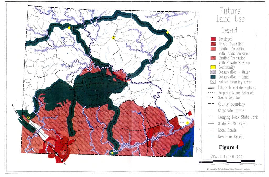
30 Urban Transition: The purpose of the Urban Transition class is to provide for future intensive urban development on land that are suitable and that will be provided with the necessary urban services to support intense urban development. Areas meeting the intent of Urban Transition classification are presently being developed for urban purposes or will be developed in the next five to ten years to accommodate anticipate population and urban growth. Limited Transition: The purpose of the Limited Transition class is to provide for development in areas that will have some services but that are only suitable for lower densities that those associated with the Urban Transition class and/or areas that are geographically remote from existing towns and municipalities. Areas meeting the intent of the Limited Transition classification will experience increased development during the planning period. They will be in a state of development necessitating some municipal type services such as community water and sewage systems. Community: The purpose of the Community class is to provide for clustered, mixed land uses at low densities to help meet the housing, shopping and employment needs of rural areas. Areas meeting the intent of the Community classification are presently developed at low densities that are suitable for private septic tank use. Municipal type services should be anticipated only to correct existing or projected public health hazards. Rural: The purpose of the Rural class is to provide for agriculture, forestry, mineral extraction and other allied land uses. Areas meeting the intent of the Rural classification are appropriate for or presently used for agriculture, forestry, mineral extraction and other uses due to their hazardous or noxious nature should be located in a relative isolated and undeveloped area. Very low density dispersed single family residential uses are appropriate within Rural class. Conservation: The purpose of the Conservation class is to provide for the effective long-term management and protection of significant, limited or irreplaceable areas. Management is needed due to the natural, cultural, recreational, scenic or natural productive values of both local and more than local concern. Figures 3 and 4 show the existing and future land use for Stokes County. 21
31
32
33 Roadway System An important stage in the development of a CTP is the analysis of the existing roadway system and its ability to serve the area s travel desires. Emphasis is placed not only on detecting the existing deficiencies, but also on understanding the causes of these deficiencies. Roadway deficiencies may be localized, resulting from problems with inadequate pavement width, intersection geometry, or intersection controls. Deficiencies may also result from system problems, such as the need to construct missing travel links, bypass routes, loop facilities, or additional radial routes. An analysis of the roadway system examines both current and future travel patterns and identifies existing and anticipated deficiencies. This is usually accomplished through a traffic crash analysis, roadway capacity deficiency analysis, and a system deficiency analysis. This information, along with population growth, economic development potential, and land use trends, is used to analyze factors that will impact the future system. Traffic Crash Analysis Traffic collisions or crashes are often used as an indicator for locating congestion and roadway problems. Crashes may be a result of the driver, or vehicle performance or the physical characteristics of the roadway. Roadway conditions and obstructions, traffic conditions, and weather may all lead to a crash. While some crashes are the fault of the driver, others may be prevented with physical design changes or traffic control changes such as the installations of stop signs or traffic signals. Crash data for the period from January 1, 2004 to December 31, 2006 was studied as part of the development of the CTP. The crash analysis considered both crash frequency and severity. Crash frequency is the total number of reported crashes, while the severity index is based on a series of weighting factors developed by the NCDOT. These factors define a fatal or incapacitating crash as 47.7 times more severe than one involving only property damage, and a crash resulting in minor injury as 11.8 times more severe than one with only property damage. In general, a higher severity index indicates more severe crashes. Listed below are levels of severity for various severity index ranges. Table 3 : Severity Index Severity Severity Index Low < 6.0 Average 6.0 to 7.0 Moderate 7.0 to 14.0 High 14.0 to 20.0 Very High >
34 Table 4 depicts a summary of the crashes occurring in the planning area between January 1, 2004 and December 31, The data represents locations with 5 or more crashes and/or a severity average greater than that of the state s 4.87 index. The Total column indicates the total number of crashes reported within 150-ft of the intersection during the study period. The severity listed is the average crash severity for that location. Crash locations are displayed is Figure 5. Table 4: Crash Locations Location of Crash* Average Severity Total no. of Crashes Map Index Road A Road B 1 NC89 Rothrock Rd SR Perch Rd Old Hwy 52 SR1147 SR Old VFW Rd Old Hwy 52 SR1152 SR NC8 NC NC89 Main US311 NC Main Third US52 Perch Rd SR Main Stokesburg US311 NC Main Smith Totals 65 * Please refer to the Crash Location Map NCDOT is actively involved with investigating and improving many of these locations. To request a more detailed analysis for any of the locations listed in Table 4, or other intersections of concern, contact the Division Traffic Engineer. Contact information for the Division Traffic Engineer is included in Appendix A. 28
35 V I R G I N I A S U R R Y C O U N T Y!( 3!( 8!( 2 Asbury Rd (SR 1416) "$ 268 Perch Rd (SR 1147) "$ Brims Grove Rd (SR 2109) Coon Rd (SR 1154) Old 52 Hwy (SR 1236) Trinity Church Rd (SR 1102) Asbury Rd (SR 1432) Brown Mountain Rd (SR 1210) "$ 66 Bud Tilley Rd (SR 1192) Oscar Frye Rd (SR 1182) Collinstown Rd (SR 1432) "$ 89 "$ 66 "$ 66 "$ 268 See Winston-Salem Comprehensive Transportation Plan "$ 89 Moore's Springs Rd (SR 1001) Mtn. View Church Rd (SR 1998) Flat Shoals Rd (SR 2019) Friendship Rd (SR 1955) Mountain View Rd (SR 1973) "$ 89 Friendship Rd (SR 1955) "$ 704 Hart Rd (SR 1497) Piney Grove Church Rd (SR 1496) Hanging Rock Rd Mountain View Dr (SR 1974) (SR 2015) "$ 8!( 4 "$ 8 "$ 8 Mountain Rd (SR 2018) "$ 8 "$ 65 "$ 704 Snow Hil Church Rd (SR 1651) Sheppard Mill Rd (SR 1674) Brook Cove Rd (SR 1941) Dodgetown Rd (SR 1695) "$ 89 Power DamRd (SR 1712)!( 1!( 6!(!( !( 7!( 9!( "$ 65 FaggRd (SR 1926) Phillips Rd (SR 1673) MLK Jr Rd (SR 1921) "$ 772 "$ 704 Hickory Fork Rd (SR 1722) 311 Old Pine Hall Rd (SR 1908) Amostown Rd (SR 1625) "$ 770 "$ 772 Pine Hall Rd (SR 1908) "$ 704 K - Fork Rd (SR 1686) Madison Rd (SR 1729) 311 R O C K I N G H A M C O U N T Y FIGURE 5 CRASH LOCATIONS January 1, 2004 to December 31, 2006 # Crash Locations Roads Railroads Planning Boundary County Boundary City Limits STOKES COUNTY Rivers and Streams µ Miles Base map date: August 2007 F O R S Y T H C O U N T Y Refer to CTP document for more details
36 Bridge Conditions Bridges are a vital element of a highway system. They represent the highest unit investment of all elements of the system. Second, any inadequacy or deficiency in a bridge reduces the value of the total investment. Third, a bridge presents the greatest opportunity of all potential highway failures for disruption of community welfare. Finally, and most importantly, a bridge represents the greatest opportunity of all highway failures for loss of life. For these reasons, it is imperative that bridges be constructed to the same design standards as the system of which they are a part. The Transportation Improvement Program (TIP) development process for bridge projects involves consideration of several evaluation methods in order to prioritize needed improvements. A sufficiency index is used to determine whether a bridge is sufficient to remain in service, or to what extent it is deficient. The index is a percentage in which 100 percent represents an entirely sufficient bridge and zero represents an entirely insufficient or deficient bridge. Factors evaluated in calculating the index are listed below: structural adequacy and safety serviceability and functional obsolescence essentiality for public use type of structure traffic safety features The NCDOT Bridge Maintenance Unit inspects all bridges in North Carolina at least once every two years. A sufficiency rating for each bridge is calculated and establishes the eligibility and priority for replacement. Bridges having the highest priority are replaced as Federal and State funds become available. A bridge is considered deficient if it is either structurally deficient or functionally obsolete. A bridge that is at least ten years old is considered structurally deficient if it is in relatively poor structural condition or has an insufficient load-carry capacity due to either the original design or to deterioration. A bridge is considered functionally obsolete if it is narrow, has inadequate under-clearances, has insufficient loadcarrying capacity, is poorly aligned with the roadway, and/or can no longer adequately serve existing traffic. A bridge must be classified as deficient in order to quality for Federal replacement funds. Additionally, the sufficiency rating must be less than 50% to qualify for replacement or less than 80% to qualify for rehabilitation under federal funding. Deficient bridges within the planning area are listed in Table 5. 31
37 Table 5: Deficient Bridges Bridge Number Route Feature Condition CTP/TIP Project 8 NC704 DAN RIVER Structurally Deficient 11 SR1166 EAST PRONG CREEK Structurally Deficient B SR1136 LITTLE YADKIN CREEK Structurally Deficient 44 NC8 TOWN FORK CREEK OVERFLOW Structurally Deficient B SR1147 US52 Functionally Obsolete 54 NC66 PINCH GUT CREEK Structurally Deficient B US311 RICKERS BRANCH Functionally Obsolete 60 NC8,NC89 DAN RIVER Functionally Obsolete B SR1961 NEATMAN CREEK Structurally Deficient 82 SR1674 DAN RIVER Structurally Deficient 103 SR1707 BRANCH OF DAN RIVER Structurally Deficient 104 SR1695 DAN RIVER Structurally Deficient 105 SR1697 SNOW CREEK Structurally Deficient B SR1696 SNOW CREEK Structurally Deficient 115 SR1908 DAN RIVER Structurally Deficient 119 SR1636 CREEK Structurally Deficient 153 SR1001 CREEK Structurally Deficient 174 SR1933 BRANCH S.FORK TOWN CREEK Structurally Deficient 176 SR1926 LICK CREEK Structurally Deficient 184 SR1175 CREEK Structurally Deficient 212 SR1224 EAST PRONG CREEK Functionally Obsolete 220 SR2017 CREEK Structurally Deficient 251 SR1185 CREEK Structurally Deficient 253 SR1402 BIG CREEK Structurally Deficient 32
38 V I R G I N I A S U R R Y C O U N T Y # Asbury Rd (SR 1416) "$ 268 Perch Rd (SR 1147) "$ 89 Brims Grove Rd (SR 2109) Coon Rd (SR 1154) Old 52 Hwy (SR 1236) Trinity Church Rd (SR 1102) Asbury Rd (SR 1432)! Brown Mountain Rd (SR 1210) "$ 66 Bud Tilley Rd (SR 1192) Oscar Frye Rd (SR 1182)! # Collinstown Rd (SR 1432)!!!! "$ 89 "$ "$ 66 "$ 268 Mtn. View Church Rd (SR 1998) "$ 89 Moore's Springs Rd (SR 1001) Flat Shoals Rd (SR 2019) "$ 89 "$ 704 Hanging Rock Rd (SR 2015) "$ 8 "$ 8 "$ 8 66 "$8 Mountain View Rd (SR 1973) See Winston-Salem Comprehensive Transportation Plan!! Friendship Rd (SR 1955) Hart Rd (SR 1497) Friendship Rd (SR 1955) Mountain View Dr (SR 1974)! Piney Grove Church Rd (SR 1496) #! Mountain Rd (SR 2018)!! Brook Cove Rd (SR 1941) "$ 65 "$ 704 Snow Hil Church Rd (SR 1651) Sheppard Mill Rd (SR 1674) Dodgetown Rd (SR 1695)! "$ 89 Power DamRd (SR 1712) 311!! 311 "$ 65! FaggRd (SR 1926) Phillips Rd (SR 1673) MLK Jr Rd (SR 1921) "$ 772 "$ 704 Hickory Fork Rd (SR 1722) Old Pine Hall Rd (SR 1908) Amostown Rd (SR 1625) "$ 770 "$ 772 Pine Hall Rd (SR 1908) "$ 704! K - Fork Rd (SR 1686) Madison Rd (SR 1729)! # R O C K I N G H A M C O U N T Y FIGURE 6 DEFICIENT BRIDGES # Functionally Obsolete Bridges Structurally Deficient Bridges Roads Railroads Planning Boundary County Boundary City Limits STOKES COUNTY Rivers and Streams µ Miles Base map date: August 2007 F O R S Y T H C O U N T Y Refer to CTP document for more details
39 Roadway Capacity Deficiencies Capacity deficiencies occur when the traffic volume of a roadway is eighty percent or more of roadway s capacity. Travel volumes are based on the total number or vehicles that use a roadway on a typical day. These volumes are based on annual average daily traffic (AADT) counts taken annually by the NCDOT Traffic Survey Group. Capacity is the maximum number of vehicles which have a reasonable expectation of passing over a given section of roadway, during a given time period under prevailing roadway and traffic conditions. Many factors contribute to the capacity of a roadway including the following: Geometry of the road, including number of lanes, horizontal and vertical alignment, and proximity of perceived obstructions to safe travel along the road; Typical users of the road, such as commuters, recreational travelers, and truck traffic; Access control, including streets and driveways, or lack thereof, along the roadway; Development of the road, including residential, commercial, and industrial developments; Number of traffic signals along the route; Peaking characteristics of the traffic on the road; Characteristics of side-roads feeding into the road; and Directional split of traffic or the percentages of vehicles traveling in each direction along a road at any given time Roadway Capacity Analysis A comparison of the 2006 travel demand volumes and their respective capacities for the major roadways in the planning area identified two small deficiencies. Table 6 and Figure 7 present 2006 volumes and capacities Roadway Capacity Analysis The capacity deficiency analysis for the 2035 design year is based upon a no build scenario. This analysis revealed several roadways within the planning area will be near or exceed capacity by the design year. Table 7 and Figure 8 present the 35
40 capacity deficiencies for the design year. Complete recommendations for these facilities are included in Chapter 2 of this report. Table Capacity Deficiencies Roadway / Description Deficiency US 311 From SR 1941 (Brook Cove Road) to 1 st Street Over Capacity US 311 From 1 st Street to SR 1928 (Stokesburg Rd) Near Capacity Table Capacity Deficiencies Roadway / Description US 311 From NC Highway 89 to NC Highway 65 US 52 From Winston Salem Planning Area to Surry County NC 89 From Power Dam Road (SR 1712) to US 311 NC 65 From Winston Salem Planning Area to US 311 Old 52 Hwy (SR 1236) From Old Winston Road (SR 1152) to Mill Street (SR 1221) Deficiency Over Capacity Over Capacity Over Capacity Near Capacity Over Capacity 36
41 V I R G I N I A S U R R Y C O U N T Y Asbury Rd (SR 1416) "$ Perch Rd (SR 1147) "$ 89 Coon Rd (SR 1154) 52 Brims Grove Rd (SR 2109) Old 52 Hwy (SR 1236) Trinity Church Rd (SR 1102) Asbury Rd (SR 1432) Brown Mountain Rd (SR 1210) Oscar Frye Rd (SR 1182) "$ 66 Bud Tilley Rd (SR 1192) Collinstown Rd (SR 1432) "$ "$ 66 "$ 66 "$ Mtn. View Church Rd (SR 1998) "$ 89 Moore's Springs Rd (SR 1001) Flat Shoals Rd (SR 2019) Friendship Rd (SR 1955) Mountain View Rd (SR 1973) "$ 89 "$ 704 Hart Rd (SR 1497) Hanging Rock Rd (SR 2015) "$ 8 "$ 8 "$ 8 "$ 8 "$ 65 "$ 704 "$ µ Comprehensive 1600 Transportation Plan See Winston-Salem Friendship Rd (SR 1955) Piney Grove Church Rd (SR 1496) Mountain View Dr (SR 1974) Mountain Rd (SR 2018) Snow Hil Church Rd (SR 1651) Sheppard Mill Rd (SR 1674) Brook Cove Rd (SR 1941) Dodgetown Rd (SR 1695) Power DamRd (SR 1712) "$ 65 FaggRd (SR 1926) Phillips Rd (SR 1673) "$ 772 MLK Jr Rd (SR 1921) "$ Hickory Fork Rd (SR 1722) 311 Old Pine Hall Rd (SR 1908) Amostown Rd (SR 1625) "$ 770 "$ 772 Pine Hall Rd (SR 1908) "$ 704 K - Fork Rd (SR 1686) 1500 Madison Rd (SR 1729) R O C K I N G H A M C O U N T Y 2006 VOLUMES AND ROADWAY DEFICIENCIES FIGURE 7 Near Capacity Over Capacity 2006 AADT Existing Capacity Network Roads Railroads Planning Boundary County Boundary City Limits Rivers and Streams STOKES COUNTY Miles F O R S Y T H C O U N T Y Base map date: August 2007 Refer to CTP document for more details
42 V I R G I N I A S U R R Y C O U N T Y n Asbury Rd (SR 1416) "$ Perch Rd (SR 1147) "$ 89 Coon Rd (SR 1154) 52 Brims Grove Rd (SR 2109) Old 52 Hwy (SR 1236) Trinity Church Rd (SR 1102) Asbury Rd (SR 1432) Brown Mountain Rd (SR 1210) Oscar Frye Rd (SR 1182) "$ 66 Bud Tilley Rd (SR 1192) Collinstown Rd (SR 1432) "$ 89 n n "$ "$ 66 "$ See Winston-Salem Mtn. View Church Rd (SR 1998) "$ 89 Moore's Springs Rd (SR 1001) 1500 n Flat Shoals Rd (SR 2019) Friendship Rd (SR 1955) Mountain View Rd (SR 1973) "$ 89 Friendship Rd (SR 1955) "$ 704 Hart Rd (SR 1497) n Piney Grove Church Rd (SR 1496) Hanging Rock Rd Mountain View Dr (SR 1974) (SR 2015) n n "$ 8 n "$ 8 "$ 8 Mountain Rd (SR 2018) 8400 "$ Brook Cove Rd (SR 1941) "$ 65 "$ 704 Snow Hil Church Rd (SR 1651) Sheppard Mill Rd (SR 1674) Dodgetown Rd (SR 1695) "$ 89 Power DamRd (SR 1712) Comprehensive Transportation Plan n n n "$ 65 FaggRd (SR 1926) Phillips Rd (SR 1673) MLK Jr Rd (SR 1921) 1900 n "$ 772 "$ Hickory Fork Rd (SR 1722) 311 Old Pine Hall Rd (SR 1908) Amostown Rd (SR 1625) "$ 770 "$ 772 Pine Hall Rd (SR 1908) "$ 704 K - Fork Rd (SR 1686) 2000 Madison Rd (SR 1729) n 311 R O C K I N G H A M C O U N T Y FIGURE VOLUMES AND ROADWAY DEFICIENCIES Near Capacity Over Capacity 2035 AADT Existing Capacity Network Roads Railroads Planning Boundary County Boundary City Limits Rivers and Streams STOKES COUNTY µ Miles Base map date: August 2007 F O R S Y T H C O U N T Y Refer to CTP document for more details
43 Level of Service (LOS) The relationship of travel demand compared to the roadway capacity determines the level of service (LOS) of a roadway. Six levels of service identify the range of possible conditions. Designations range from LOS A, which represents the best operating conditions, to LOS F, which represents the worst operating conditions. Design requirements for roadways vary according to the desired capacity and level of service. LOS D indicates practical capacity of a roadway, or the capacity at which the public begins to express dissatisfaction. Recommended improvements and overall design of the transportation plan were based upon achieving a minimum LOS D on existing facilities and a LOS C on new facilities. The six levels of service are described below and illustrated in Figure 9. LOS A: LOS A describes free-flow operations. Free-flow speeds prevail. Vehicles are almost completely unimpeded in their ability to maneuver within the traffic stream. The effects of incidents or point breakdowns are easily absorbed at this level. LOS B: represents reasonably free flow, and free-flow speeds are maintained. The ability to maneuver within the traffic stream is only slightly restricted, and the general level of physical and psychological comfort provided to drivers is still high. The effects of minor incidents and point breakdowns are still easily absorbed. LOS C: provides for flow with speeds at or near the free flow speed of the freeway. Freedom to maneuver within the traffic stream is noticeably restricted, and lane changes require more care and vigilance on the part of the driver. Minor incidents may still be absorbed, but the local deterioration in service will be substantial. Queues may be expected to form behind any significant blockage. LOS D: is the level at which speeds begin to decline slightly with increasing flows and density begins to increase somewhat more quickly. Freedom to maneuver within the traffic stream is more noticeably limited, and the driver experiences reduced physical and psychological comfort levels. Even minor incidents can be expected to create queuing, because the traffic stream has little space to absorb disruptions. LOS E: describes operation at capacity. Operations at this level are volatile, because there are virtually no usable gaps in the traffic stream. Vehicles are closely spaced, leaving little room to maneuver within the traffic stream. Any disruption of the traffic stream, such as vehicles entering from a ramp or a vehicle changing lanes, can establish a disruption wave that propagates throughout the upstream traffic flow. At capacity, the traffic stream has no ability to dissipate even the most minor disruption, and any incident can be expected to produce a serious breakdown with extensive queuing. Maneuverability within the traffic stream is extremely limited, and the level of physical and psychological comfort afforded the driver is poor. 41

44 LOS F: describes breakdowns in vehicular flow; and with such stop-and-go conditions, it is difficult to predict a flow rate. These conditions generally exist within queues forming behind breakdown points. Breakdowns occur when the ratio of existing demand to actual capacity or of forecast demand to estimated capacity exceeds The various reasons for these breakdowns (as identified in the HCM) include traffic incidents, which can cause a temporary reduction in the capacity of a short segment; and points of recurring congestion, such as merge or weaving segments and lane drops. Figure 9 - Level of Service Illustrations Source: 2000 Highway Capacity Manual 42
45 V. Environmental Screening In recent years, the environmental considerations associated with transportation construction have come to the forefront of the planning process. Section 102 of the National Environmental Policy Act (NEPA) requires the completion of an Environmental Impact Statement (EIS) for projects that have a significant impact on the environment. The EIS includes impacts on wetlands, wildlife, water quality, historic properties, and public lands. While this report does not cover the environmental concerns in as much detail as an EIS would, consideration for many of these factors was incorporated in to the development of the CTP. These factors were also incorporated into the recommended improvements. Environmental features found in the study area are shown in Figure 10. Wetlands Wetlands are those lands where saturation with water is the dominant factor in determining the nature of soil development and the types of plant and animal communities living in the soil and on its surface. Wetlands are crucial ecosystems in our environment. They help regulate and maintain the hydrology of our rivers, lakes, and streams by storing and slowly releasing floodwaters. Wetlands help maintain the quality of water by storing nutrients, reducing sediment loads, and reducing erosion. They are also critical to fish and wildlife populations by providing an important habitat for approximately one-third of the plant and animal species that are federally listed as threatened or endangered. The National Wetland Inventory showed several wetlands throughout the study area. See Figure 10 for more information. Threatened and Endangered Species The Threatened and Endangered Species Act of 1973 allows the U. S. Fish and Wildlife Service to impose measures on the Department of Transportation to mitigate the environmental impacts of a transportation project on endangered animal and plant species, as well as critical wildlife habitats. Locating any rare species that exist within the study area during this early planning stage will help to avoid or minimize impacts. A preliminary review of the Federally Listed Threatened and Endangered Species in the study area was completed to determine what effects, if any, the recommended improvements may have on wildlife. Mapping from the N.C. Department of Environment and Natural Resources revealed occurrences of threatened or endangered plant and/or animal species in the study area, which are summarized in Table 8. 43
46 Table 8: Endangered Species Common Name Scientific name Vertebrate: Orangefin madtom Noturus gilberti Rustyside sucker Thoburnia hamiltoni Invertebrate: Diana fritillary (butterfly) Green floater James Spinymussel Margarita River skimmer Vascular Plant: Butternut Cuthbert turtlehead Schweinitz's sunflower Speyeria diana Lasmigona subviridis Pleurobema collina Macromia margarita Juglans cinerea Chelone cuthbertii Helianthus schweinitzii Small-anthered bittercress Cardamine micranthera Sweet pinesap Updated: Monotropsis odorata Historic Sites Section 106 of the National Historic Preservation Act requires the Department of Transportation to identify historic properties listed in, as well as eligible for, the National Register of Historic Places (NRHP). NCDOT must consider the impacts of transportation projects on these properties and consult with the Federal Advisory Council on Historic Preservation. N.C. General Statute (a) requires the NCDOT to identify historic properties listed on the National Register, but not necessarily those that are eligible to be listed. NCDOT must consider the impacts and consult with the N.C. Historical Commission, but is not bound by their recommendations. The location of historic sites within the study area was investigated to determine any possible impacts resulting from the recommended improvements. There are currently nine properties and two districts listed on the National Register in Stokes County. 44
47 Structures: Christ Episcopal Church Jessups Mill Matthew Moore House Moratock Iron Furnace Pine Hall Rock House Spencer Mill Stokes County Courthouse Walnut Cove Colored School District: Hanging Rock State Park (Bath House) Danbury Historic District Of the historic sites, there are none that will be impacted by the recommended improvements of this plan. Archaeological Sites The location of recorded archaeological sites was researched to determine the possible impacts of proposed roadway projects. This initial investigation identified no current archaeological sites. However, archaeological sites are often difficult to identify without actual field excavation. As a result, possible sites may not be identified during the initial planning process; therefore, each proposed project should be evaluated individually prior to construction. Educational Facilities The locations of educational facilities in Stokes County were considered during the development of this transportation plan. No proposed facilities or improvements shall displace any school or other educational facility. 45
 Asbury Rd (SR 1432) \"$ 66 Bud Tilley Rd (SR 1192) Oscar Frye Rd (SR 1182) Collinstown Rd (SR 1432) \"$ 89 \"$ 66 \"$ 66 \"$ 268 \"$ 89!( \"$ 89 \"$ 704 \"$ 8 \"$ 8!( \"$8 66 \"$!")
48 !( V I R G I N I A S U R R Y C O U N T Y "$ 268 "$ 89 Brims Grove Rd (SR 2109) Perch Rd (SR 1147) Asbury Rd (SR 1416) Brown Mountain Rd (SR 1210) Coon Rd (SR 1154) Old 52 Hwy (SR 1236) Trinity Church Rd (SR 1102) Asbury Rd (SR 1432) "$ 66 Bud Tilley Rd (SR 1192) Oscar Frye Rd (SR 1182) Collinstown Rd (SR 1432) "$ 89 "$ 66 "$ 66 "$ 268 "$ 89!( "$ 89 "$ 704 "$ 8 "$ 8!( "$8 66 "$!( "$ See Winston-Salem Comprehensive Transportation Plan Moore's Springs Rd (SR 1001) Mtn. View Church Rd (SR 1998) Flat Shoals Rd (SR 2019) Friendship Rd (SR 1955) Mountain View Rd (SR 1973) Hart Rd (SR 1497) Friendship Rd (SR 1955) Piney Grove Church Rd (SR 1496) Hanging Rock Rd (SR 2015) Mountain View Dr (SR 1974) "$ 8 Mountain Rd (SR 2018)!(!(!( "$ 65 "$ 704 Snow Hill Church Rd (SR 1651) Sheppard Mill Rd (SR 1674) Brook Cove Rd (SR 1941) Dodgetown Rd (SR 1695) "$ 89 Power DamRd (SR 1712) !( "$ 65 FaggRd (SR 1926) Phillips Rd (SR 1673) "$ 772 MLK Jr Rd (SR 1921) "$ 704 Hickory Fork Rd (SR 1722) Old Pine Hall Rd (SR 1908)!( Amostown Rd (SR 1625) "$ 770 "$ 772 Pine Hall Rd (SR 1908) "$ 704 K - Fork Rd (SR 1686) Madison Rd (SR 1729)!( 311!( R O C K I N G H A M C O U N T Y FIGURE 10 ENVIRONMENTAL FEATURES!( Air Quality Pollution Discharge Sites!( Benthic Monitoring Result Sites!( NPDES Major Sites!( NPDES Minor Sites!( Unverified Stream Gaging Stations!@ Stream Gaging Stations National Wetland Inventory Significant Aquatic Endangered Species Habitats High Quality Outstanding Resource Waters Groundwater Recharge and Discharge Areas Water Supply Watershed Rivers and Streams Lakes Roads Railroads Planning Boundary County Boundary City Limits STOKES COUNTY µ Miles F O R S Y T H C O U N T Y Base map date: August 2007 Refer to CTP document for more details
49 VI. Public Involvement The NCDOT s Transportation Planning Branch has a long history of making public involvement a key element in the development of any long-range transportation plan, regardless the size of the area. This chapter is designed to provide an overview of the public involvement process implemented for development of the transportation plan for the county. The Stokes County Comprehensive Transportation Plan was requested in January of 2005 by the County Planning Director. The Transportation Planning Branch met with the Planning Director on July 20, 2005 to identify the primary transportation concerns and to define the scope of the study. On October 19, 2005, a meeting was held with various public officials and staff. These included: Planning, Economic Development, School Board, EMS, City of King, Town of Walnut Cove, and YVEDDI Transportation. CTP presentations were also made at Planning Board and County Commissioner Meetings to further discuss the transportation concerns. One public drop-in session was held on March 1, This meeting was held in the County Commissioner s Meeting Room in Danbury. The Northwest Piedmont RPO published an advertisement in the news paper and it was posted on Stokes County and NWPRPO s website. As part of a public involvement process, in October 2006, the Stokes County Transportation Survey was made available. The survey could be obtained from the town hall (Danbury and Walnut Cove), various public libraries, and the County Commissioner s office. The survey was also made available online and was sent via postal mail to 800 randomly selected households. Approximately 100 responses were received and analyzed. Public hearings were held during County Commissioners and Town Officials meetings to discuss the plan recommendations and to solicit further input from the public. The plan was adopted by Danbury Town Officials on February 27, 2008, Walnut Cove Town Officials on March 4, 2008, and the Stokes County Commissioners on April 1, The Town of Walnut Cove Commissioners adopted the CTP with the provision that there be no widening of the road between the intersection of NC 89/US 311 and US 311/US 65, and that the section of road be maintained as a two-lane highway. Officials have indicated their desire to keep on street parking. 49
50 The Northwest Piedmont RPO endorsed the CTP on June, 17, The North Carolina Department of Transportation adopted the Stokes County CTP on September 4,
51 A P P E N D I C E S
52 Appendix A Resources and Contacts North Carolina Department of Transportation Customer Service Office DOT4YOU ( ) Secretary of Transportation 1501 Mail Service Center Raleigh, NC (919) Board of Transportation Member* Current contact information for the Board of Transportation may be accessed from the NCDOT homepage below or by calling the Customer Service Office. Highway Division Engineers Division specific contact information can be found at Division Engineer Contact the Division Engineer with general questions concerning NCDOT activities within each Division; information on Small Urban Funds. Division Construction Engineer Contact the Division Construction Engineer for information concerning major roadway improvements under construction. Division Traffic Engineer Contact the Division Traffic Engineer for information concerning high crash locations. District Engineer Contact the District Engineer for information regarding Driveway Permits, Right of Way, Encroachments, and Development Reviews. County Maintenance Engineer Contact the County Maintenance Engineer regarding any maintenance activities, such as drainage. A-1
53 Transportation Planning Branch (TPB) Contact the Transportation Planning Branch with long-range planning questions Mail Service Center Raleigh, NC (919) Secondary Roads Office Contact the Secondary Roads Office for information regarding the Industrial Access Funds Program. P.O. Box Raleigh, NC (919) Program Development Branch Contact the Program Development Branch for information concerning Roadway Official Corridor Maps and the Transportation Improvement Program (TIP) Mail Service Center Raleigh, NC (919) Project Development & Environmental Branch (PDEA) Contact PDEA for information on environmental studies for projects that are included in the TIP Mail Service Center Raleigh, NC (919) Highway Design Branch Contact the Highway Design Branch for information regarding alignment for projects that are included in the TIP Mail Service Center Raleigh, NC (919) Public Transportation Division Contact the Public Transportation Division for information public transit systems Mail Service Center Raleigh, NC (919) A-2
54 Other NCDOT Departments Contact information for other departments within the NCDOT not listed here are available by calling the Customer Service Office or by visiting the NCDOT homepage at Other State Government Offices Division of Community Assistance Contact the Division of Community Assistance for information regarding the Community Planning Program. You may find their contact information at: Strategic Planning Office (SPOT) Contact SPOT for information regarding the project prioritization Mail Service Center Raleigh, NC (919) Division of Bicycle and Pedestrian Transportation (DBPT) Contact DBPT for information regarding Bicycle and Pedestrian planning 1552 Mail Service Center Raleigh, NC (919) Piedmont Authority for Regional Transportation (PART) 7800 Airport Center Drive, Suite 102 Greensboro, NC (336) A-3
55 Division 9, District 2 Contacts (Stokes County) District II Engineer Board Member Mr. John P. Rhyne, PE Mr. Ralph H. Womble 375 Silas Creek Parkway 635 N. Trade Street Winston Salem, NC Winston Salem, NC (336) (336) jprhyne@ncdot.gov rwomble@ncdot.gov Division Engineer Division Project Manager Mr. Pat Ivey, PE Mr. Brett Abernathy, PE, PLS 375 Silas Creek Parkway 375 Silas Creek Parkway Winston Salem, NC Winston Salem, NC (336) (336) pivey@ncdot.gov jbabernathy@ncdot.gov Division Maintenance Engineer Mr. David W. Spainhour, PE 375 Silas Creek Parkway 375 Silas Creek Parkway Winston Salem, NC Winston Salem, NC Division Construction Engineer Mr. Keith E. Raulston, PE (336) (336) dspainhour@ncdot.gov kraulston@ncdot.gov Division Traffic Engineer Mr. J. P. Couch, PE 375 Silas Creek Parkway 1554 Mail Service Center Winston Salem, NC Raleigh, NC Triad Planning Group Supervisor Dr. Wayne C. Davis, Ph.D, PE (336) (919) jpcouch@ncdot.gov wcdavis@ncdot.gov Transportation Planning Manager Western Group Manager Mr. Mike Bruff, PE Mrs. Earlene Thomas. PE 1554 Mail Service Center 1554 Mail Service Center Raleigh, NC Raleigh, NC (919) (919) mbruff@ncdot.gov ewthomas@ncdot.gov NW Piedmont RPO Planner Mr. Marc Allred 400 West Fourth St, Ste Mail Service Center Winston Salem, NC Raleigh, NC NCDOT NW Piedmont RPO Coord. Ms. Vernia Wilson (336) (919) mallred@nwpcog.org vrwilson1@ncdot.gov A-4
56 Appendix B Comprehensive Transportation Plan Definitions Highway Map Freeways - Functional purpose high mobility, high volume, high speed - Posted speed 55 mph or greater - Cross section minimum four lanes with continuous median - Multi-modal elements High Occupancy Vehicles/High Occupancy Transit lanes, busways, truck lanes, park-and-ride facilities at/near interchanges, adjacent shared use paths (separate from roadway and outside ROW) - Type of access control full control of access - Access management interchange spacing (urban one mile; non-urban three miles); at interchanges on the intersecting roadway, full control of access for 1,000 or for 350 plus 650 island or median; use of frontage roads, rear service roads - Intersecting facilities interchange or grade separation (no signals or atgrade intersections) - Driveways not allowed Expressways - Functional purpose high mobility, high volume, medium-high speed - Posted speed 45 to 60 mph - Cross section minimum four lanes with median - Multi-modal elements High Occupancy Vehicle lanes, busways, very wide paved shoulders (rural), shared use paths (separate from roadway but within ROW) - Type of access control limited or partial control of access; - Access management minimum interchange/intersection spacing 2000 feet; median breaks only at intersections with minor roadways or to permit U-turns; use of frontage roads, rear service roads; driveways limited in location and number; use of acceleration/deceleration or right turning lanes - Intersecting facilities interchange; at-grade intersection for minor roadways; right-in/right-out and/or left-over or grade separation (no signalization for through traffic); - Driveways right-in/right-out only; direct driveway access via service roads or other alternate connections. Boulevards - Functional purpose moderate mobility; moderate access, moderate volume, medium speed B-1
57 - Posted speed 30 to 55 mph - Cross section two or more lanes with median (median breaks allowed for U-turns per Driveway Manual - Multi-modal elements bus stops, bike lanes (urban) or wide paved shoulders (rural), sidewalks (urban - local government option) - Type of access control limited control of access, partial control of access, or no control of access - Access management two lane facilities may have medians with crossovers, medians with turning pockets or turning lanes; use of acceleration/deceleration or right turning lanes is optional; for abutting properties, use of shared driveways, internal out parcel access and crossconnectivity between adjacent properties is strongly encouraged - Intersecting facilities at grade intersections and driveways; interchanges at special locations with high volumes - Driveways primarily right-in/right-out, some right-in/right-out in combination with median leftovers; major driveways may be full movement when access is not possible using an alternate roadway. Other Major Thoroughfares - Functional purpose balanced mobility and access, moderate volume, low to medium speed - Posted speed 25 to 55 mph - Cross section four or more lanes without median - Multi-modal elements bus stops, bike lanes/wide outer lane (urban) or wide paved shoulder (rural), sidewalks (urban) - Type of access control no control of access - Access management continuous left turn lanes; for abutting properties, use of shared driveways, internal out parcel access and cross-connectivity between adjacent properties is strongly encouraged - Intersecting facilities intersections and driveways - Driveways full movement on two lane with center turn lane as permitted by the NCDOT Driveway Manual Minor Thoroughfares - Functional purpose balanced mobility and access, moderate volume, low to medium speed - Posted speed 25 to 45 mph - Cross section ultimately three lanes (no more than one lane per direction) or less without median; - Multi-modal elements bus stops, bike lanes/wide outer lane (urban) or wide paved shoulder (rural), sidewalks (urban) - ROW no control of access - Access management continuous left turn lanes; for abutting properties, use of shared driveways, internal out parcel access and cross-connectivity between adjacent properties is strongly encouraged - Intersecting facilities intersections and driveways B-2
58 - Driveways full movement on two lane with center turn lane as permitted by the NCDOT Driveway Manual Existing Roadway facilities that are not recommended to be improved. Needs Improvement Roadway facilities that need to be improved for capacity, safety, or system continuity. The improvement to the facility may be widening, other operational strategies, increasing the level of access control along the facility, or a combination of improvements and strategies. Needs improvement does not refer to the maintenance needs of existing facilities. Recommended Roadway facilities on new location that are needed in the future. Interchange Through movement on intersecting roads is separated by a structure. Turning movement area accommodated by on/off ramps and loops. Grade Separation Through movement on intersecting roads is separated by a structure. There is no direct access between the facilities. Full Control of Access Connections to a facility provided only via ramps at interchanges. No private driveway connections allowed. Limited Control of Access Connections to a facility provided only via ramps at interchanges (major crossings) and at-grade intersections (minor crossings and service roads). No private driveway connections allowed. Partial Control of Access Connections to a facility provided via ramps at interchanges, at-grade intersections, and private driveways. Private driveway connections shall be defined as a maximum of one connection per parcel. One connection is defined as one ingress and one egress point. These may be combined to form a two-way driveway (most common) or separated to allow for better traffic flow through the parcel. The use of shared or consolidated connections is highly encouraged. No Control of Access Connections to a facility provided via ramps at interchanges, at-grade intersections, and private driveways. Public Transportation and Rail Map Bus Routes The primary fixed route bus system for the area. Does not include demand response systems. Fixed Guideway Any transit service that uses exclusive or controlled rightsof-way or rails, entirely or in part. The term includes heavy rail, commuter rail, light rail, monorail, trolleybus, aerial tramway, included plane, cable car, automated guide way transit, and ferryboats. Operational Strategies Plans geared toward the non-single occupant vehicle. This includes but is not limited to High Occupancy Vehicle (HOV) lanes or express bus service. Rail Corridor Locations of railroad tracks that are either active or inactive tracks. These tracks were used for either freight or passenger service. - Active rail service is currently provided in the corridor; may include freight and/or passenger service B-3
59 - Inactive right of way exists; however, there is no service currently provided; tracks may or may not exist - Recommended It is desirable for future rail to be considered to serve an area. High Speed Rail Corridor Corridor designated by the U.S. Department of Transportation as a potential high-speed rail corridor. - Existing Corridor where high-speed rail service is provided (there are currently no existing high-speed corridor in North Carolina). - Recommended Proposed corridor for high-speed rail service. Rail Stop A railroad station or stop along the railroad tracks Intermodal Connector a location where more than one mode of public transportation meet such as where light rail and a bus route come together in one location or a bus station. Park and Ride Lot a strategically located parking lot that is free of charge to anyone who parks a vehicle and commutes by transit or in a carpool. Bicycle Map On-Road Existing Conditions for bicycling on the highway facility are adequate to safely accommodate cyclists. On-Road Needs Improvement At the systems level, it is desirable for the highway facility to accommodate bicycle transportation; however, highway improvements are necessary to create safe travel conditions for the cyclists. On-Road Recommended At the systems level, it is desirable for a recommended highway facility to accommodate bicycle transportation. The highway should be designed and built to safely accommodate cyclists. Off Road Existing A facility that accommodates bicycle transportation (may also accommodate pedestrians, i.e. a greenway) and is physically separated from a highway facility usually on a separate right-of-way. Off Road Needs Improvement A facility that accommodates bicycle transportation (may also accommodate pedestrians, e.g. greenways) and is physically separated from a highway facility usually on a separate right-of-way that will not adequately serve future bicycle needs. Improvements may include but are not limited to widening, paving (not re-paving), and improved horizontal or vertical alignment. Off Road Recommended A facility needed to accommodate bicycle transportation (may also accommodate pedestrians, e.g. greenways) and is physically separated from a highway facility usually on a separate right-ofway. This may also include greenway segments that do not necessarily serve a transportation function but intersect recommended facilities on the highway map or public transportation and rail map. Pedestrian Map Definitions for the pedestrian map are under development. B-4
60 Appendix C Street Tabulation and Recommendations This appendix includes a detailed tabulation of all streets identified as elements of the Stokes County Comprehensive Transportation Plan. The table includes a description of the roads by sections, as well as the length, cross section, and rightof-way for each section. Also included are the existing and projected average daily traffic volumes, roadway capacity, and the recommended ultimate lane configuration. Due to space constraints, these recommended cross sections are given in the form of an alphabetic code. A detailed description of each of these codes and an illustrative figure for each can be found in Appendix D.
61 2006 CONDITIONS 2035 CONDITIONS FACILITY & SECTION DIST Mi. ROW (Ft.) LANES SURF WIDTH (Ft) 2006 AADT CAPACITY 2035 AADT PROPOSED CAPACITY REC Cross SECTION US 311 Rockingham County Line to Walnut Cove City Limit ADQ Walnut Cove City Limit(East) to NC ADQ NC 89 to 7th St E 7th St. to 5th St E 5th St. to SR E SR 1941 to 1st St E 1st St. to SR E SR 1928 to NC G NC 65 to Forsyth County Line ADQ US 52 Surry County Line to Winston Salem UAB L NC Highway 772 SR 1690 to US ADQ NC 704 to SR K NC Highway 770 NC 704 to Rockingham County Line ADQ NC Highway 704 NC 89 to NC ADQ NC 8 to SR K SR 1651 to NC K NC 770 to NC ADQ NC 772 to Rockingham County Line K NC Highway 268 Surry County Line to SR K SR 1182 to NC K NC 66 to NC ADQ NC Highway 89 Surry County Line to NC ADQ NC 66 to SR ADQ SR 1432 to NC ADQ NC 704 to NC ADQ NC 268 to NC ADQ C-3
62 2006 CONDITIONS 2035 CONDITIONS FACILITY & SECTION DIST Mi. ROW (Ft.) LANES SURF WIDTH (Ft) 2006 AADT CAPACITY 2035 AADT PROPOSED CAPACITY REC Cross SECTION NC 8 to SR ADQ SR 1712 to US K NC Highway 66 NC 89 to NC K NC 268 to SR K SR 1001 to SR K SR 2019 to Winston Salem UAB ADQ NC Highway 65 US 311 to Forsyth County Line ADQ US 311 to SR ADQ Winston Salem UAB to US F NC 65 Re-route (Proposed) US 311 to MLK Jr. Rd N/A N/A N/A N/A N/A K NC Highway 8 Virginia State Line to SR K SR 1496 to SR K SR 1655 to NC K NC 89 to SR K SR 2015 to Danbury City Limit (North) K Danbury City Limit (North) to SR K SR 1674 to SR K SR 1695 to Winston Salem UAB K State Road 2109 (Brims Grove Rd) SR 1182 to SR K State Road 2019 (Flat Shoals Rd) NC 66 to SR ADQ State Road 2018 ( Mountain Rd) SR 2019 to NC ADQ State Road 2015 (Hanging Rock Rd) SR 1001 to NC 8/ ADQ C-4
63 2006 CONDITIONS 2035 CONDITIONS FACILITY & SECTION DIST Mi. ROW (Ft.) LANES SURF WIDTH (Ft) 2006 AADT CAPACITY 2035 AADT PROPOSED CAPACITY REC Cross SECTION State Road 1998 (Mtn View Church Rd) SR 2019 to Winston Salem UAB ADQ State Road 1974 (Mountain View Rd) SR 1955 to NC K State Road 1973 (Mountain View Rd) Winston Salem UAB to SR ADQ State Road 1955 (Friendship Rd) SR 2019 to SR K SR 1974 to Winston Salem UAB ADQ State Road 1941 (Brook Cove Rd) NC 8 to US ADQ State Road 1926 (Fagg Rd) US 311 to NC K State Road 1921 (MLK Jr Rd) NC 65 to SR K State Road 1908 (Pine Hall Rd) US 311 to Forsyth County Line ADQ State Road 1747 (GW Southern Rd) NC 8 to NC ADQ State Road 1729 (Madison Rd) NC 772 to Rockingham County Line ADQ State Road 1722 (Hickory Fork Rd) NC 772 to US K State Road 1695 (Dodgetown Rd) NC 8 to NC K C-5
64 2006 CONDITIONS 2035 CONDITIONS FACILITY & SECTION DIST Mi. ROW (Ft.) LANES SURF WIDTH (Ft) 2006 AADT CAPACITY 2035 AADT PROPOSED CAPACITY REC Cross SECTION State Road 1686 (K. Fork Rd) NC 770 to Rockingham County Line ADQ State Road 1674 (Sheppard Mill Rd) SR 1670 to SR K NC 8 to SR K State Road 1673 (Phillps Rd) SR 1674 to NC ADQ State Road 1651 (Snow Hill Church Rd) NC 8 to NC K State Road 1625 (Amostown Rd) NC 704 to Rockingham County line ADQ State Road 1497 (Hart Rd) NC 704 to SR ADQ State Road 1496 (Piney Grove Church Rd) NC 8 to NC K State Road 1432 (Collinstown Rd) Virginia State Line to SR K State Road 1416 (Ashbury Rd) SR 1416 to NC K State Road 1413 (Ashbury Rd) SR 1432 to NC ADQ State Road 1236 (Old Hwy 52 Rd) Surry County Line to SR ADQ SR 1154 to SR K SR 1152 to SR K SR 1221 to Winston Salem UAB K State Road 1210 (Brown Mountain Rd) Surry County Line to NC ADQ C-6
65 2006 CONDITIONS 2035 CONDITIONS FACILITY & SECTION DIST Mi. ROW (Ft.) LANES SURF WIDTH (Ft) 2006 AADT CAPACITY 2035 AADT PROPOSED CAPACITY REC Cross SECTION State Road 1192 (Bud Tilley Rd) NC 268 to NC ADQ State Road 1182 (Oscar Frye Rd) SR 2109 to NC K State Road 1157 (Volunteer Rd) SR 1154 to SR ADQ State Road 1154 (Coon Rd) SR 1157 to SR K State Road 1147 (Perch Rd) Surry County Line To US K US 52 to SR ADQ State Road 1102 (Trinity Church Rd) Surry County Line to Winston Salem UAB K State Road 1001 (Moore s Spring Rd) NC 66 to NC ADQ Southern Connector (Proposed) Winston Salem UAB to US N/A N/A N/A N/A N/A K C-7
66 Appendix D Typical Transportation Cross-Sections Cross section requirements for roadways vary according to the capacity and level of service to be provided. Universal standards in the design of roadways are not practical. Each roadway section must be individually analyzed and its cross section determined based on the volume and type of projected traffic, existing capacity, desired level of service, and available right-of-way. These cross sections are typical for facilities on new location and where right-of-way constraints are not critical. For widening projects and urban projects with limited right-of-way, special cross sections should be developed that meet the needs of the project. On all existing and proposed roadways delineated on the CTP, adequate right-ofway should be protected or acquired for the recommended cross sections. In addition to cross section and right-of-way recommendations for improvements, Appendix C may recommend ultimate needed right-of-way for the following situations: roadways which may require widening after the current planning period, roadways which are borderline adequate and accelerated traffic growth could render them deficient, and roadways where an urban curb and gutter cross section may be locally desirable because of urban development or redevelopment. Recommended design standards relating to grades, sight distances, degree of curve, superelevation, and other considerations for roadways are given in Appendix E. The typical cross sections are described below. Typical Cross Sections A: Four Lanes Divided with Median - Freeway Cross section "A" is typical for four-lane divided highways in rural areas that may have only partial or no control of access. The minimum median width for this cross section is 46 feet, but a wider median is desirable. B: Seven Lanes - Curb & Gutter Cross section "B" is typically not recommended for new projects. When the conditions warrant six lanes, cross section D should be recommended. Cross section B should be used only in special situations such as when widening from a five-lane section where right-of-way is limited. Even in these situations, consideration should be given to converting the center turn lane to a median so that cross section D is the final cross section. D-1
67 C: Five Lanes - Curb & Gutter Typical for major thoroughfares, cross section "C" is desirable where frequent left turns are anticipated as a result of abutting development or frequent street intersections. D: Six Lanes Divided with Raised Median - Curb & Gutter E: Four Lanes Divided with Raised Median - Curb and Gutter Cross sections "D" and "E" are typically used on major thoroughfares where left turns and intersection streets are not as frequent. Left turns would be restricted to a few selected intersections. The 16-ft median is the minimum recommended for an urban boulevard-type cross section. In most instances, monolithic construction should be utilized due to greater cost effectiveness, ease and speed of placement, and reduced future maintenance requirements. In certain cases, grass or landscaped medians result in greatly increased maintenance costs and an increase danger to maintenance personnel. Non-monolithic medians should only be recommended when the above concerns are addressed. F: Four Lanes Divided - Boulevard, Grass Median Cross section "F" is typically recommended for urban boulevards or parkways to enhance the urban environment and to improve the compatibility of major thoroughfares with residential areas. A minimum median width of 24 ft is recommended, with 30 ft being desirable. G: Four Lanes - Curb and Gutter Cross section "G" is recommended for major thoroughfares where projected travel indicates a need for four travel lanes but traffic is not excessively high, left turning movements are light, and right-of-way is restricted. An additional left turn lane would likely be required at major intersections. This cross section should be used only if the above criteria are met. If right-of-way is not restricted, future strip development could take place and the inner lanes could become de facto left turn lanes. H: Three Lanes - Curb and Gutter In urban environments, thoroughfares that are proposed to function as one-way traffic carriers would typically require cross section H. I: Two Lanes Curb and Gutter, Parking both sides J: Two Lanes Curb and Gutter, Parking one side Cross section I and J are usually recommended for urban minor thoroughfares since these facilities usually serve both land service and traffic service functions. Cross-section I would be used on those minor thoroughfares where parking on both sides is needed as a result of more intense development. D-2
68 K: Two Lanes - Paved Shoulder Cross section "K" is used in rural areas or for staged construction of a wider multilane cross section. On some thoroughfares, projected traffic volumes may indicate that two travel lanes will adequately serve travel for a considerable period of time. For areas that are growing and future widening will be necessary, the full right-of-way of 100 ft should be required. In some instances, local ordinances may not allow the full 100-ft. In those cases, 70 ft should be preserved with the understanding that the full 70-ft will be preserved by use of building setbacks and future street line ordinances. L: Six Lanes Divided with Grass Median - Freeway Cross section L is typical for controlled access freeways. The 46-ft grass median is the minimum desirable width, but variation from this may be permissible depending upon design considerations. Right-of-way requirements are typically 228 ft or greater, depending upon cut and fill requirements. M: Eight Lanes Divided with Raised Median - Curb and Gutter Also used for controlled access freeways, cross section "M" may be recommended for freeways going through major urban areas or for routes projected to carry very high volumes of traffic. N: Five Lanes with Curb & Gutter, Widened Curb Lanes O: Two Lanes/Shoulder Section P: Four Lanes Divided with Raised Median Curb & Gutter, Widened Curb Lanes If there is sufficient bicycle travel along the thoroughfare to justify a bicycle lane or bikeway, additional right-of-way may be required to contain the bicycle facilities. The North Carolina Bicycle Facilities Planning and Design Guidelines should be consulted for design standards for bicycle facilities. Cross sections N, O and P are typically used to accommodate bicycle travel. General The urban curb and gutter cross sections all illustrate the sidewalk adjacent to the curb with a buffer or utility strip between the sidewalk and the minimum rightof-way line. This permits adequate setback for utility poles. If it is desired to move the sidewalk farther away from the street to provide additional separation for pedestrians or for aesthetic reasons, additional right-of-way must be provided to insure adequate setback for utility poles. The right-of-way shown for each typical cross section is the minimum amount required encompassing the street, sidewalks, utilities, and drainage facilities. Cut and fill requirements may require either additional right-of-way or construction easements. Obtaining construction easements is becoming the more common practice for urban roadway construction. D-3
69 Bicycle Cross Sections Cross sections B-1, B-2, B-3, B-4, and B-5 are typical bicycle cross sections. Contact the NCDOT Division of Bicycle and Pedestrian Transportation for more information regarding these cross-sections. B-1: Four Lanes Divided with Wide Outside Lanes B-2: Five Lanes with Wide Outside Lanes A widened outside lane is an effective way to accommodate bicyclists riding in the same lane with motor vehicles. With a wide outside lane, motorists do not have to change lanes to pass a bicyclist. The additional width in the outside lane also improves sight distance and provides more room for vehicles to turn onto the roadway. Therefore, on roadways with bicycle traffic, widening the outside lane can improve the capacity of that roadway. Also, by widening the outside lane by a few extra feet both motorists and bicyclists have more space in which to maneuver. This facility type is generally considered for use in urban, suburban, and occasionally rural conditions on roadways where there is a curb and gutter. Wide outside lanes can be applied to several different roadway cross sections. B-3: Bicycle Lanes on Collector Streets Bicycle lanes may be considered when it is desirable to delineate road space for preferential use by cyclists. Streets striped with bicycle lanes should be part of a connected bikeway system rather than being an isolated feature. Bicycle lanes function most effectively in mid-block situations by separating bicyclists from overtaking motor vehicles. Integrating bicyclists into complicated intersection traffic patterns can sometimes be problematic. Strip development areas, or roadways with a high number of commercial driveways, tend to be less suitable for bicycle lanes due to frequent and unpredictable motorist turning movements across the path of straight-through cyclists. Striped bike lanes can be effective as a safety treatment, especially for less experienced bicyclists. Two-lane residential/collector streets with lower traffic volume, low-posted speed limit, adequate roadway width for both bike lanes and motor vehicle travel lanes, and an absence of complicated intersections. A median-divided multi-lane roadway with lower traffic volumes and a low volume of right and left turning traffic would be a more appropriate location for bicycle lanes than a high traffic volume undivided multi-lane roadway with a continuous center turn lane. Most bicyclists will choose a route that combines direct access with lower traffic volumes. An origin and destination of less than 4 miles is desirable to generate usage on a facility. B-4: Wide Paved Shoulders On urban streets with curb and gutter, wide outside lanes and bicycle lanes are usually the preferred facilities. Shoulders for bicycle use are not typically provided on roadways with curb and gutter. On rural roadways where bicycle travel is common, such as roads in coastal resort areas, wide paved shoulders are highly desirable. D-4
70 On secondary roadways without curb and gutter where there are few commercial driveways and intersections with other roadways, many bicyclists prefer riding on wide, smoothly paved shoulders. B-5: Multi-use Pathway When properly located, multi-use pathway can be a safer type of facility for novice and child bicyclists because they do not have to share the path with motor vehicles. The design standards used for this cross section provides adequate width for two-directional use by both cyclists and pedestrians, provisions of good sight distance, avoidance of steep grades and tight curves, and minimal crossflow by motor vehicles. A multi-use pathway can serve a variety of purposes, including recreation and transportation. This pathway should not be located immediately adjacent to a roadway because of safety considerations at intersections with driveways and roads. Sidewalks should never be used as a multi-use pathway. D-5
71 UTILITY UTILITY R/W R/W UTILITY UTILITY R/W R/W UTILITY UTILITY R/W R/W R/W R/W TYPICAL HIGHWAY CROSS SECTIONS A C L 150' - 200' (URBAN) 250' - 300' (RURAL) 12' 12' 12' 4' - 10' P.S. VARIABLE 6' 4' P.S. 46' MINIMUM MEDIAN 6' 4' P.S. 12' 12' 12' 4' - 10' P.S. VARIABLE 6:1 6:1 FOUR LANES DIVIDED WITH MEDIAN Freeway / Expressway B CL 120' (MIN.) 10' 5' 3' 2' 12' DES. 11' MIN. 12' DES. 11' MIN. 12' DES. 11' MIN. 12' DES. 12' DES. 12' DES. 12' DES. 11' MIN. 11' MIN. 11' MIN. 11' MIN. 2' 3' 10' 5' SIDEWALK SIDEWALK 2'-6" CURB AND GUTTER SEVEN LANE - CURB & GUTTER Other Major Thoroughfare 2'-6" CURB AND GUTTER C C L 100' (MIN.) 10' 5' SIDEWALK 3' 2' 12' DES. 11' MIN. 12' DES. 11' MIN. 12' DES. 12' DES. 12' DES. 11' MIN. 11' MIN. 11' MIN. 2' 3' 10' 5' SIDEWALK 2'-6" CURB AND GUTTER FIVE LANE - CURB & GUTTER Other Major Thoroughfare 2'-6" CURB AND GUTTER D CL 150' (MIN). 10' 5' SIDEWALK 3' 2' 12' DES. 12' DES. 12' DES. 11' MIN. 11' MIN. 11' MIN. 23' DES. 16' MIN. 12' DES. 11' MIN. 12' DES. 11' MIN. 12' DES. 11' MIN. 2' 3' 10' 5' SIDEWALK 2'-6" CURB AND GUTTER 1'-6" CURB AND GUTTER SIX LANES DIVIDED WITH RAISED MEDIAN - CURB & GUTTER Expressway / Boulevard 2'-6" CURB AND GUTTER revised
72 UTILITY UTILITY R/W R/W UTILITY UTILITY R/W R/W UTILITY UTILITY R/W R/W UTILITY UTILITY R/W R/W TYPICAL HIGHWAY CROSS SECTIONS E CL 110' (MIN). 10' 5' SIDEWALK 3' 2' 12' DES. 12' DES. 11' MIN. 11' MIN. 23' DES. 16' MIN. 12' DES. 11' MIN. 12' DES. 11' MIN. 2' 3' 10' 5' SIDEWALK 2'-6" CURB AND GUTTER 1'-6" CURB AND GUTTER FOUR LANES DIVIDED WITH RAISED MEDIAN - CURB & GUTTER Expressway / Boulevard 2'-6" CURB AND GUTTER F C L 120' - 135' 10' 5' SIDEWALK 3' 2' 12' DES 11' MIN 12' DES 30' - 46' 12' DES 12' DES 11' MIN 11' MIN 11' MIN 6' SHLD. 2'- 4' P.S. 6' SHLD. 2'- 4' P.S. 2' 3' 10' 5' SIDEWALK 6:1 6:1 2'-6" CURB AND GUTTER FOUR LANES DIVIDED - GRASS MEDIAN Expressway / Boulevard 2'-6" CURB AND GUTTER G CL 90' (MIN). 10' 5' SIDEWALK 3' 2' 12' DES. 12' DES. 11' MIN. 11' MIN. 12' DES. 11' MIN. 12' DES. 11' MIN. 2' 3' 10' 5' SIDEWALK 2'-6" CURB AND GUTTER FOUR LANES - CURB & GUTTER Other Major Thoroughfare 2'-6" CURB AND GUTTER H CL 80' (MIN). 10' 5' SIDEWALK 3' 2' 12' DES. 11' MIN. 12' DES. 11' MIN. 12' DES. 11' MIN. 2' 3' 10' 5' SIDEWALK 2'-6" CURB AND GUTTER THREE LANES - CURB & GUTTER Other Major Thoroughfare 2'-6" CURB AND GUTTER
73 R/W R/W UTILITY UTILITY R/W R/W UTILITY UTILITY R/W R/W TYPICAL HIGHWAY CROSS SECTIONS I CL 80' (MIN). 10' 5' SIDEWALK 3' 2' 8' 12' DES. 8' 2' PARALLEL 11' MIN. PARALLEL PARKING PARKING 12' DES. 11' MIN. 3' 10' 5' SIDEWALK 2'-6" CURB AND GUTTER TWO LANES - CURB & GUTTER PARKING ON EACH SIDE Minor Thoroughfare 2'-6" CURB AND GUTTER J CL 70' (MIN). 10' 5' SIDEWALK 3' 2' 8' 12' DES. 2' 10' PARALLEL 11' MIN. PARKING 12' DES. 11' MIN. 3' 5' SIDEWALK 2'-6" CURB AND GUTTER TWO LANES - CURB & GUTTER PARKING ON ONE SIDE Minor Thoroughfare 2'-6" CURB AND GUTTER K CL 70' - 100' 2' - 4' P.S. 10' 12' DES. 10' 11' MIN. 12' DES. 11' MIN. 2' - 4' P.S. TWO LANES - PAVED SHOULDER Minor Thoroughfare
74 UTILITY UTILITY R/W R/W R/W R/W TYPICAL HIGHWAY CROSS SECTIONS L C L 300' (MIN) 12' 12' 12' 4' - 10' P.S. VARIABLE 12' 6' - 12' SHLD. VARIABLE 4' P.S. 46' MINIMUM MEDIAN 6' - 12' SHLD. VARIABLE 4' P.S. 12' 12' 12' 12' 4' - 10' P.S. VARIABLE 6:1 6:1 SIX LANES DIVIDED WITH GRASS MEDIAN Freeway / Expressway M C L 160' (MIN). 10' 5' 3' SIDEWALK 2' 12' DES. 12' DES. 12' DES. 12' DES. 11' MIN. 11' MIN. 11' MIN. 11' MIN. 23' DES. 16' MIN. 12' DES. 11' MIN. 12' DES. 11' MIN. 12' DES. 11' MIN. 12' DES. 11' MIN. 2' 10' 3' 5' SIDEWALK 2'-6" CURB AND GUTTER 1'-6" CURB AND GUTTER EIGHT LANES DIVIDED WITH RAISED MEDIAN - CURB & GUTTER Expressway / Boulevard 2'-6" CURB AND GUTTER
75 Typical Bicycle Cross Sections WIDE CURB LANES B 1 4-LANE MEDIAN DIVIDED TYPICAL SECTION With Wide Outside Lanes B-2 5-LANE TYPICAL SECTION With Wide Outside Lanes NCDOT Bicycle Facilities Guide: Types of Bicycle Accommodations
76 Typical Bicycle Cross Sections B-3 BICYCLE LANES ON COLLECTOR STREETS Existing Roadway Restriping to Accommodate Bicycle Lanes (Does Not Allow On-Street Parking) NCDOT Bicycle Facilities Guide: Types of Bicycle Accommodations

77 Typical Bicycle Cross Sections B-4 WIDE PAVED SHOULDERS Existing Roadway Roadway Retrofitted with 4-Ft Paved Shoulders * If speeds are higher than 40 mph, shoulder widths greater than 4 are recommended. NCDOT Bicycle Facilities Guide: Types of Bicycle Accommodations
Last Reval. Tax Rate Equiv
 BY POPULATION () 2009 1 Mecklenburg 940,697 362,667,757 1,009,935,274 35.91 820,770,410 2,633,085 0.3208 0.0022 2011 2019 117,089,446,050 0.8166 100.15 0.8178 97.97 98.72 86.44 19,186,309 0.0164-0.0142
FBA as % % Non- % Vehicl. Net Tax. Tax Value to Sales Adj. Tax. Fd Bal Avail Gen Fd Exp. Tax Rate
 BY POPULATION Rank County Pop. () (GFE) of GFE Cash & Inv Inv. Earn. Earn. Equiv Reval Reval 2009 Value Value Coll. es Coll es Coll Uncoll Equiv Equiv 1 Mecklenburg 923,944 273,947,901 1,240,144,414 22.09
SALES ASSESSMENT RATIO STUDIES AS OF JANUARY 1, 2013
 SALES ASSESSMENT RATIO STUDIES AS OF JANUARY 1, 2013 North Carolina Department of Revenue Property Tax Division Introduction This report is a compilation of the sales assessment ratio studies, which were
Certificates of Participation, Qualified Zone Academy Bonds, Qualified School Construction Bonds, and other Special Indebtedness for Schools
 Construction Bonds, and other Special Indebtedness for Burke 01/19/2006 COPS, SERIES 2006A $25,940,000 $24,379,737 94.0% Davie 01/21/2006 COPS, SERIES 2006 $17,050,000 $11,963,475 70.2% Surry 01/27/2006
20 indicators of wellness health, youth behavior and safety, education, and economic development.
 The Roadmap of Need is a whole child needs assessment for North Carolina youth, produced annually by the Public School Forum of North Carolina s Center for Afterschool Programs (NC CAP). The Roadmap includes
Collaborative Partnerships: A Strategy for Improving Community Health Presented by: Ed Johnson, RLA, ASLA
 Collaborative Partnerships: A Strategy for Improving Community Health Presented by: Ed Johnson, RLA, ASLA Monday June 1, 2015 Objectives Making the Connection: Cross-sector partnerships for safety and
15A NCAC 10B.0203 DEER (WHITE-TAILED) (EFFECTIVE UNTIL JULY 31, 2018) (a) Open Seasons (All Lawful Weapons) for hunting deer: (1) Deer With Visible
 (EFFECTIVE UNTIL JULY 31, 2018) (a) Open Seasons (All Lawful Weapons) for hunting deer: (1) Deer With Visible") 15A NCAC 10B.0203 DEER (WHITE-TAILED) (EFFECTIVE UNTIL JULY 31, 2018) (a) Open Seasons (All Lawful Weapons) for hunting deer: (1) Deer With Visible Antlers. Deer with antlers or spikes protruding through
15A NCAC 10B.0203 DEER (WHITE-TAILED) (EFFECTIVE UNTIL JULY 31, 2018) (a) Open Seasons (All Lawful Weapons) for hunting deer: (1) Deer With Visible Antlers. Deer with antlers or spikes protruding through
SYSTEM LEVEL TEACHER TURNOVER REPORT
 SYSTEM LEVEL TEACHER TURNOVER REPORT 2003-2004 Prepared by: Public Schools of North Carolina Department of Public Instruction Division of Human Resource Management October 2004 SYSTEM LEVEL TEACHER TURNOVER
28,618 people joined the 2017 Holiday Challenge.
 The Holiday Challenge is a free online weight maintenance program, offered from Thanksgiving to New Year s Eve. This 7 week program includes weekly e newsletters, daily tips, healthy recipes, and small
Secondary Road Program
 Secondary Road Program Joint Legislative Transportation Oversight Committee October 5, 2012 1 Secondary Roads Program The Big Picture The Secondary Road System Needs and Project Types Paved and Unpaved
STREET AND HIGHWAY PLAN
 STREET AND HIGHWAY PLAN Introduction The street and highway system in the Winston-Salem Urban Area consists of thousands of miles of traffic carrying facilities, ranging from short local residential streets
TEACHER TURNOVER REPORT. Annual Report on the Reasons Teachers Leave
 TEACHER TURNOVER REPORT Annual Report on the Reasons Teachers Leave 2008-2009 Prepared by: Public Schools of North Carolina Department of Public Instruction Center for Recruitment and Retention Talent
Clackamas County Comprehensive Plan
 ROADWAYS The County s road system permits the movement of goods and people between communities and regions, using any of a variety of modes of travel. Roads provide access to virtually all property. They
Pedestrian Crash Facts
 North Carolina Pedestrian Crash Facts 2011-2015 Prepared for The North Carolina Department of Transportation Division of Bicycle and Pedestrian Transportation Prepared by Libby Thomas Daniel Levitt January
City of Wayzata Comprehensive Plan 2030 Transportation Chapter: Appendix A
 A1. Functional Classification Table A-1 illustrates the Metropolitan Council s detailed criteria established for the functional classification of roadways within the Twin Cities Metropolitan Area. Table
JONESBORO HIGHWAY 63 HIGHWAY 18 CONNECTOR STUDY
 JONESBORO HIGHWAY 63 HIGHWAY 18 CONNECTOR STUDY Craighead County May 2007 JONESBORO HIGHWAY 63 HIGHWAY 18 CONNECTOR STUDY Craighead County May 2007 Prepared by Planning and Research Division Arkansas State
39,004 people joined the 2018 Holiday Challenge. That represents a 36% increase in participation from 2017.
 The Holiday Challenge is a free online weight maintenance program, offered from Thanksgiving to New Year s Eve. This 7-week program includes weekly e-newsletters, daily tips, healthy recipes, and practical
Chapter 5 Future Transportation
 Chapter 5 Future Transportation The Future Land Use Plan identifies the desired land use designations. The land uses desired for Crozet depend, in large part, on the success of the transportation system,
Table of Contents SURVEY SALARY DATA EMPLOYEE BENEFITS
 Table of Contents SURVEY SALARY DATA Population, Valuation, County Commissioner, and County Manager 2 Assistant County Manager and Assistant to the Manager 3 Board of Elections, Elections Director, and
north carolina safe routes conference building a path to the future
 north carolina safe routes conference building a path to the future 2 welcome Dear walking and bicycling to school partner, Welcome to North Carolina s Safe Routes to School Conference! It s our pleasure
Report to the North Carolina General Assembly
 Public Schools of North Carolina State Board of Education Department of Public Instruction Report to the North Carolina General Assembly Headcount of Limited English Proficient Students to Fiscal Research
Based on data collected in the fall of 2005
 Based on data collected in the fall of 2005 School of Government, UNC Chapel Hill Established in 1931, the Institute of Government provides training, advisory, and research services to public officials
Modal Interrelationships: A bicycle lane is proposed between Harrington Ave and Swanns Station Rd.
 DRAFT PROJECT PAGE July 12, 2007 Main St / Broadway Rd (SR 1579) Project Statement Project Recommendation: From Avent Ferry Rd (NC 42) to the Harnett County line, Broadway Rd/Main St is recommended to
North Carolina Department of Transportation American Recovery and Reinvestment Act of 2009 Division One Highway Infrastructure Program Summary
 Division One Highway Infrastructure Program Summary 1 Hyde NC 12 Northern Ferry Dock Ocracoke Village R-5149 Resurface and Widening to Accommodate Bicycling 13.3 $3,310,000 $0 $3,310,000 Jul-09 1 Dare
APPENDIX G: INTERSECTION NEEDS AT OKEECHOBEE BOULEVARD
 APPENDIX G: INTERSECTION NEEDS AT OKEECHOBEE BOULEVARD INTERSECTION NEEDS AT SR 7 and OKEECHOBEE BOULEVARD SR 7 Extension Project Development and Environment (PD&E) Study From Okeechobee Boulevard (SR
DRAFT BUENA VISTA 2020 TRANSPORTATION PLAN
 DRAFT BUENA VISTA 2020 TRANSPORTATION PLAN DEVELOPED BY THE TRANSPORTATION PLANNING DIVISION OF THE VIRGINIA DEPARTMENT OF TRANSPORTATION IN COOPERATION WITH THE U.S. DEPARTMENT OF TRANSPORTATION, FEDERAL
ARTINSVILLE ENRY OUNTY REA RANSPORTATION TUDY
 ARTINSVILLE ENRY OUNTY REA RANSPORTATION TUDY DEVELOPED BY THE TRANSPORTATION AND MOBILITY PLANNING DIVISION OF THE VIRGINIA DEPARTMENT OF TRANSPORTATION IN COOPERATION WITH THE U.S. DEPARTMENT OF TRANSPORTATION,
TRASBURG RANSPORTATION
 TRASBURG RANSPORTATION LAN DEVELOPED BY THE TRANSPORTATION PLANNING DIVISION OF THE VIRGINIA DEPARTMENT OF TRANSPORTATION IN COOPERATION WITH THE U.S. DEPARTMENT OF TRANSPORTATION, FEDERAL HIGHWAY ADMINISTRATION
CITY OF COCOA BEACH 2025 COMPREHENSIVE PLAN. Section VIII Mobility Element Goals, Objectives, and Policies
 CITY OF COCOA BEACH 2025 COMPREHENSIVE PLAN Section VIII Mobility Element Goals, Objectives, and Policies Adopted August 6, 2015 by Ordinance No. 1591 VIII MOBILITY ELEMENT Table of Contents Page Number
West Dimond Blvd Upgrade Jodhpur Street to Sand Lake Road
 West Dimond Blvd Jodhpur St to Sand Lake CSS Transportation Project Summary Municipality of Anchorage Project # 05 005 Project Manager: John Smith, P.E. (MOA PM&E) Project Administrator: Julie Makela,
Recommendations. Implementation
 Recommendations This report documents the development of the Winston-Salem MPO CTP as shown in Figure 2-1. This chapter presents recommendations for each mode of transportation in the MPO. Implementation
ACTIVE TRANSPORTATION
 ACTIVE TRANSPORTATION Mobility 2040 Supported Goals Improve the availability of transportation options for people and goods. Support travel efficiency measures and system enhancements targeted at congestion
City of Homewood Transportation Plan
 City of Homewood Transportation Plan Prepared for: City of Homewood, Alabama Prepared by: Skipper Consulting, Inc. May 2007 TABLE OF CONTENTS INTRODUCTION... 1 BACKGROUND INFORMATION... 1 EXISTING TRANSPORTATION
Regional Transportation Needs Within Southeastern Wisconsin
 Regional Transportation Needs Within Southeastern Wisconsin #118274 May 24, 2006 1 Introduction The Southeastern Wisconsin Regional Planning Commission (SEWRPC) is the official areawide planning agency
5.0 Roadway System Plan
 Southwest Boise Transportation Study Page 16 5.0 Roadway System Plan The Roadway System Plan outlines roadway improvements in the Initial Study Area. It forecasts future deficiencies on the arterial system,
o n - m o t o r i z e d transportation is an overlooked element that can greatly enhance the overall quality of life for the community s residents.
 N o n - m o t o r i z e d transportation is an overlooked element that can greatly enhance the overall quality of life for the community s residents. 84 Transportation CHAPTER 11 INTRODUCTION Transportation
Exhibit 1 PLANNING COMMISSION AGENDA ITEM
 Exhibit 1 PLANNING COMMISSION AGENDA ITEM Project Name: Grand Junction Circulation Plan Grand Junction Complete Streets Policy Applicant: City of Grand Junction Representative: David Thornton Address:
Comprehensive Transportation Plan Warren County
 Comprehensive Transportation Plan Warren County March, 2010 Warren County Comprehensive Transportation Plan Technical Report Prepared by the: Transportation Planning Branch North Carolina Department of
Access Management Regulations and Standards
 Access Management Regulations and Standards Efficient highway operation Reasonable property access Concept of Access Management The way to manage access to land development while simultaneously preserving
March 17, Dear Colleagues of the Joint Legislative Oversight Committee on the NC Lottery,
 0 March 17, 2016 Dear Colleagues of the Joint Legislative Oversight Committee on the NC Lottery, Thank you for allowing me the opportunity to address the Lottery Committee on March 10 th. I sincerely appreciate
MOUNTAIN HOUSE SPECIFIC PLAN I 9.1 INTRODUCTION ASSUMPTIONS TRANSPORTATION FACILITIES TRANSPORTATION IMPROVEMENTS PHASING 9.
 CHAPTER NINE: TRANSPORTATION AND CIRCULATION 9.1 INTRODUCTION 9.1 9.2 ASSUMPTIONS 9.1 9.3 TRANSPORTATION FACILITIES 9.1 9.4 TRANSPORTATION IMPROVEMENTS PHASING 9.3 LIST OF FIGURES LIST OF TABLES Figure
Chapter 5 FUNCTIONAL CLASSIFICATION
 Chapter 5 FUNCTIONAL CLASSIFICATION Functional classification is a system by which streets and roadways may be distinguished by types according to their function within the entire transportation network.
Project Description Form 6V
 Project Description Form 6V Basic Project Information Submitting Jurisdiction/Agency: Prince William County Project Title: Route 15 Widening: Route 55 to south of RR tracks & Construct RR Overpass Project
Chapter 4 Traffic Analysis
 Chapter 4 Traffic Analysis PURPOSE The traffic analysis component of the K-68 Corridor Management Plan incorporates information on the existing transportation network, such as traffic volumes and intersection
Basalt Creek Transportation Refinement Plan Recommendations
 Basalt Creek Transportation Refinement Plan Recommendations Introduction The Basalt Creek transportation planning effort analyzed future transportation conditions and evaluated alternative strategies for
Chapter 7. Transportation. Transportation Road Network Plan Transit Cyclists Pedestrians Multi-Use and Equestrian Trails
 Chapter 7 Transportation Transportation Road Network Plan Transit Cyclists Pedestrians Multi-Use and Equestrian Trails 7.1 TRANSPORTATION BACKGROUND The District of Maple Ridge faces a number of unique
Circulation in Elk Grove includes: Motor vehicles, including cars and trucks
 Circulation, as it is used in this General Plan, refers to the many ways people and goods move from place to place in Elk Grove and the region. Circulation in Elk Grove includes: Motor vehicles, including
Route 7 Corridor Study
 Route 7 Corridor Study Executive Summary Study Area The following report analyzes a segment of the Virginia State Route 7 corridor. The corridor study area, spanning over 5 miles in length, is a multi
FI-2 I-66 Between Route 29, Lee Highway and Route 15, James Madison Highway
 TRANSPORTATION PLAN INTENT Transportation is the key to the economic and social development of Prince William County and especially to the I 66/Route 29 Sector Plan area. This includes transportation for
This page intentionally left blank.
 This page intentionally left blank. COMMUNITY Coweta Community Overview Coweta Coweta, a residential community located in Wagoner County, is a suburb of Tulsa situated southeast of the metropolitan area
Access Management Regulations and Standards
 Access Management Regulations and Standards January 2014 Efficient highway operation Reasonable property access Concept of Access Management The way to manage access to land development while preserving
Executive Summary June 2015
 Executive Summary June 2015 Highway 112 Corridor Study Benton and Washington Counties Executive Summary June 2015 Prepared by Transportation Planning and Policy Division Arkansas State Highway and Transportation
M-58 HIGHWAY ACCESS MANAGEMENT STUDY Mullen Road to Bel-Ray Boulevard. Prepared for CITY OF BELTON. May 2016
 M-58 HIGHWAY ACCESS MANAGEMENT STUDY Prepared for CITY OF BELTON By May 2016 Introduction Missouri State Highway 58 (M-58 Highway) is a major commercial corridor in the City of Belton. As development has
Traffic Impact Analysis Walton Acres at Riverwood Athletic Club Clayton, NC
 Traffic Impact Analysis Walton Acres at Riverwood Athletic Club Clayton, NC 1. TABLE OF CONTENTS INTRODUCTION...1 1.1. Site Location and Study Area...1 1.2. Proposed Land Use and Site Access...2 1.3.
Access Management Regulations and Standards for Minor Arterials, Collectors, Local Streets
 Access Management Regulations and Standards for Minor Arterials, Collectors, Local Streets September 2009 Paul Grasewicz Access Management Administrator Concept of Access Management The way to manage access
GOAL 2A: ESTABLISH AND MAINTAIN A SAFE, CONVENIENT, AND EFFICIENT MULTI-MODAL TRANSPORTATION SYSTEM TO MOVE PEOPLE AND GOODS THROUGHOUT THE CITY.
 2. TRANSPORTATION ELEMENT The purpose of this element is to assist in establishing an adequate transportation system within the City and to plan for future motorized and non-motorized traffic circulation
3.0 Future Conditions
 3.0 Future Conditions In order to be able to recommend appropriate improvements to the transportation system of the Town, it is important to first understand the nature and volume of traffic that is expected
FACULTY School of Government The University of North Carolina at Chapel Hill ISBN
 The School of Government at the University of North Carolina at Chapel Hill works to improve the lives of North Carolinians by engaging in practical scholarship that helps public officials and citizens
Classification Criteria
 SCHEDULE D TO RECOMMENDED OFFICIAL PLAN AMENDMENT NO. 40 SCHEDULE C-4 Road Criteria Criteria Traffic Service Objective Land Service/Access Typical Daily Traffic Volume Flow characteristics Travel Speed
Chapter 6 Transportation Plan
 Chapter 6 Transportation Plan Transportation Plan Introduction Chapter 6 Transportation Plan Transportation Plan Introduction This chapter describes the components of Arvada s transportation system, comprised
NM-POLICY 1: Improve service levels, participation, and options for non-motorized transportation modes throughout the County.
 Transportation PRINCE WILLIAM COUNTY 2008 COMPREHENSIVE PLAN NON-MOTORIZED PLAN CONTENTS Goals, Policies, and Action Strategies Table 4 (Bike Facility Classifications and Descriptions) Table 5 (Bike Facility
Highway Project Scoring Worksheet Project Name: Ike Brooks Rd/Rives Chapel Church Rd Improvements (SPOT ID: H090571)
") Highway Project Scoring Worksheet Project Name: Ike Brooks Rd/Rives Chapel Church Rd Improvements (SPOT ID: H9571) COUNTY RANK SCORING (5% of total) Countywide Ranking (1 points maximum) Enter ranking
Highway Project Scoring Worksheet Project Name: Ike Brooks Rd/Rives Chapel Church Rd Improvements (SPOT ID: H9571) COUNTY RANK SCORING (5% of total) Countywide Ranking (1 points maximum) Enter ranking
Recommended Roadway Plan Section 2 - Land Development and Roadway Access
 Recommended Roadway Plan Section 2 - Land Development and Roadway Access SECTION 2 Land Development and Roadway Access 2.1 Land Use and Access Management The Federal Highway Administration (FHWA) defines
MCTC 2018 RTP SCS and Madera County RIFP Multi-Modal Project Eval Criteria GV13.xlsx
 MCTC 8 RTP SCS and Madera County RIFP Multi-Modal Project Eval Criteria GV.xlsx Madera County Transportation Commission Regional Transportation Plan / Sustainable Communities Strategy Multi-Modal Project
Highway 111 Corridor Study
 Highway 111 Corridor Study June, 2009 LINCOLN CO. HWY 111 CORRIDOR STUDY Draft Study Tea, South Dakota Prepared for City of Tea Sioux Falls Metropolitan Planning Organization Prepared by HDR Engineering,
Solana Beach Comprehensive Active Transportation Strategy (CATS)
") Solana Beach Comprehensive Active Transportation Strategy (CATS) 3.0 Goals & Policies The Solana Beach CATS goals and objectives outlined below were largely drawn from the Solana Beach Circulation Element
Solana Beach Comprehensive Active Transportation Strategy (CATS) 3.0 Goals & Policies The Solana Beach CATS goals and objectives outlined below were largely drawn from the Solana Beach Circulation Element
Highway 49, Highway 351 and Highway 91 Improvements Feasibility Study Craighead County
 Highway 49, Highway 351 and Highway 91 Improvements Feasibility Study Craighead County Executive Summary March 2015 Highway 49, Highway 351 and Highway 91 Improvements Feasibility Study Craighead County
LEA Name School Name XDX XD Total 4A CLASSIFICATION
 LEA Name School Name XDX XD Total 4A CLASSIFICATION MECKLENBURG COUNTY MYERS PARK HIGH - 2,973 MCDOWELL COUNTY MCDOWELL HIGH # 2,911 MECKLENBURG COUNTY HOPEWELL HIGH - 2,764 WAKE COUNTY WAKEFIELD HIGH
CONNECTING PEOPLE TO PLACES
 CONNECTING PEOPLE TO PLACES 82 EAST BENCH MASTER PLAN 07 Introduction The East Bench transportation system is a collection of slow moving, treelined residential streets and major arteries that are the
WELCOME TO OPEN HOUSE # 1 June 14, 2017
 Langstaff Road Weston Road to Highway 7 Class Environmental Assessment Study WELCOME TO OPEN HOUSE # 1 June 14, 2017 Please sign in and join our mailing list Purpose of Open House #1 & Study Area York
MUTCD Part 6G: Type of Temporary Traffic Control Zone Activities
 MUTCD Part 6G: Type of Temporary Traffic Control Zone Activities 6G.01 Typical Applications Each temporary traffic control (TTC) zone is different. Many variables, such as location of work, highway type,
PEDESTRIAN ACTION PLAN
 ATTACHMENT 2 CITY OF SANTA MONICA PEDESTRIAN ACTION PLAN CITY OF SANTA MONICA PEDESTRIAN ACTION PLAN This page intentionally left blank EXECUTIVE SUMMARY CHAPTER 1 EXECUTIVE SUMMARY Setting the Stage
4. ENVIRONMENTAL IMPACT ANALYSIS 9. TRANSPORTATION AND TRAFFIC
 4. ENVIRONMENTAL IMPACT ANALYSIS 9. TRANSPORTATION AND TRAFFIC 4.9.1 INTRODUCTION The following section addresses the Proposed Project s impact on transportation and traffic based on the Traffic Study
County of Greenville South Carolina. Traffic Calming Program Neighborhood Traffic Education Program and Speed Hump Program
 County of Greenville South Carolina Traffic Calming Program Neighborhood Traffic Education Program and Speed Hump Program (rev) August 2008 I. PURPOSE The potential negative impacts from vehicular traffic
WYDOT DESIGN GUIDES. Guide for. Non-NHS State Highways
 WYDOT DESIGN GUIDES Guide for Non-NHS State Highways 2014 GUIDE FOR Non-NATIONAL HIGHWAY SYSTEM (Non-NHS) STATE HIGHWAYS PRESERVATION REHABILITATION RECONSTRUCTION INTRODUCTION This Guide is directed to
2. TRANSPORTATION ELEMENT.
 2. TRANSPORTATION ELEMENT. The purpose of this element is to assist in establishing an adequate transportation system within the City and to plan for future motorized and non-motorized traffic circulation
Roadway Classification Design Standards and Policies. Pueblo, Colorado November, 2004
 Roadway Classification Design Standards and Policies Pueblo, Colorado November, 2004 Table of Contents Page Chapter 1. General Provisions 1.1 Jurisdiction 3 1.2 Purpose and Intent 3 1.3 Modification 3
Complete Streets Training. Georgia Municipal Association June 27, 2016
 Complete Streets Training Georgia Municipal Association June 27, 2016 Overview What are CS? GDOT s Policy Case Study 2 What are Complete Streets? According to the National Complete Streets Coalition, complete
ADOT Statewide Bicycle and Pedestrian Program Summary of Phase IV Activities APPENDIX B PEDESTRIAN DEMAND INDEX
 ADOT Statewide Bicycle and Pedestrian Program Summary of Activities APPENDIX B PEDESTRIAN DEMAND INDEX May 24, 2009 Pedestrian Demand Index for State Highway Facilities Revised: May 29, 2007 Introduction
This page intentionally left blank.
 This page intentionally left blank. COMMUNITY Glenpool Community Overview Glenpool Glenpool is a city of nearly 12,000 residents located in Tulsa County southwest of Tulsa and Jenks. The city is growing
INTERMODAL TRANSPORTATION PLAN
 INTRODUCTION INTERMODAL TRANSPORTATION PLAN Effective intermodal transportation implies a public policy for actively decreasing the demand for automobile trips and consequently reducing automobile related
CITY OF BLOOMINGTON COMPLETE STREETS POLICY
 CITY OF BLOOMINGTON COMPLETE STREETS POLICY POLICY OBJECTIVE: The City of Bloomington will enhance safety, mobility, accessibility and convenience for transportation network users of all ages and abilities,
WYDOT DESIGN GUIDES. Guide for. NHS Arterial (Non-Interstate)
") WYDOT DESIGN GUIDES Guide for NHS Arterial (Non-Interstate) 2014 GUIDE FOR NATIONAL HIGHWAY SYSTEM (NHS) HIGHWAYS (NHS ARTERIALS, Non-Interstate) PRESERVATION REHABILITATION RECONSTRUCTION INTRODUCTION
WYDOT DESIGN GUIDES Guide for NHS Arterial (Non-Interstate) 2014 GUIDE FOR NATIONAL HIGHWAY SYSTEM (NHS) HIGHWAYS (NHS ARTERIALS, Non-Interstate) PRESERVATION REHABILITATION RECONSTRUCTION INTRODUCTION
Trends in North Carolina s County Road Conditions,
 Trends in North Carolina s County Road Conditions, 1998-2004 By David T. Hartgen, Ph.D., P.E. Professor of Transportation Studies University of North Carolina at Charlotte Charlotte, North Carolina 28223
Goodlettsville Bicycle and Pedestrian Plan Executive Summary
 Goodlettsville Bicycle and Pedestrian Plan July 2010 In Cooperation with the Nashville Area Metropolitan Planning Executive Organization Summary Introduction Progressive and forward thinking communities
Access Location, Spacing, Turn Lanes, and Medians
 Design Manual Chapter 5 - Roadway Design 5L - Access Management 5L-3 Access Location, Spacing, Turn Lanes, and Medians This section addresses access location, spacing, turn lane and median needs, including
2015 Florida Main Street Annual Conference. Complete Streets Equal Stronger Main Streets
 WHAT ARE COMPLETE STREETS? CASE STUDIES COMPLETING YOUR MAIN STREET 2015 Florida Main Street Annual Conference St. Petersburg, Florida August 19, 2015 WHAT ARE COMPLETE STREETS? CASE STUDIES COMPLETING
MASTER THOROUGHFARE PLAN
 MASTER THOROUGHFARE PLAN Master Thoroughfare Plan Update November 2015 Prepared for Town of Northlake AVO 30659 11/11/2015 1201 North Bowser Road Richardson, Texas 75081 Firm Registration No. 312 MASTER
Madison Urban Area and Dane County. Bicycle Transportation Plan Summary. September Introduction. Bicycle Plan Scope and Planning Process
 Bicycle Transportation Plan Summary Madison Urban Area and Dane County Introduction September 2000 Bicycling is an important mode of transportation in the Madison urban area and countywide that is available
INTRODUCTION THOROUGHFARE SYSTEM CLASSIFICATIONS
 INTRODUCTION The thoroughfare plan will assist public officials in the development of a specialized system for efficient and safe movement of vehicular traffic while minimizing potential conflicts with
Develop a Multi-Modal Transportation Strategy (Theme 6)
") DEVELOP A MULTI-MODAL TRANSPORTATION STRATEGY (THEME 6) WHY IS THIS THEME ADDRESSED? Develop a Multi-Modal Transportation Strategy (Theme 6) Statement of Ideal Reduce resident and visitor reliance on single
DEVELOP A MULTI-MODAL TRANSPORTATION STRATEGY (THEME 6) WHY IS THIS THEME ADDRESSED? Develop a Multi-Modal Transportation Strategy (Theme 6) Statement of Ideal Reduce resident and visitor reliance on single
City of Gainesville Transportation/Roadway Needs PROJECT SUMMARY
 A1 Roadway Resurfacing $23,846,000 TYPE: Preservation of existing system Roadway resurfacing A2 Signal Replacement $6,000,000 TYPE: Preservation of existing system Replace traffic signals. B1 W 6th St
Street Paving and Sidewalk Policy
 City Commission Policy 600 Street Paving and Sidewalk Policy DEPARTMENT: Public Works DATE ADOPTED: June 7, 1995 DATE OF LAST REVISION: December 10, 2014 Policy No. 600.01 AUTHORITY: PASS City of Tallahassee-Leon
2.0 Existing Conditions
 20 2.0 Existing Conditions 2.1 Land Use, Future Growth Patterns, Physical Barriers Geographic Overview Sutter County s land use pattern is characterized by extensive agricultural areas, significant natural
Tulsa Metropolitan Area LONG RANGE TRANSPORTATION PLAN
 Tulsa Metropolitan Area LONG RANGE TRANSPORTATION PLAN Indian Nations Council of Governments August 2005 CONTACTING INCOG In developing the Destination 2030 Long Range Transportation Plan, INCOG s Transportation
Town of Bethlehem. Planning Assessment. Bethlehem Town Board
 Town of Bethlehem US 9W Corridor Transportation Planning Assessment Presented e to: Bethlehem Town Board June 2009 Overview Study Background Route 9W Corridor Conditions and Improvements Selkirk Bypass
TOWN OF CHAPEL HILL POLICY AND PROCEDURES FOR TRAFFIC CALMING MEASURES
 TOWN OF CHAPEL HILL POLICY AND PROCEDURES FOR TRAFFIC CALMING MEASURES (Adopted by the Town Council on June 30, 2004) (Revised December 6, 2010) (Revised February 8, 2016) POLICY AND PROCEDURES FOR TRAFFIC
Bicycle Master Plan Goals, Strategies, and Policies
 Bicycle Master Plan Goals, Strategies, and Policies Mobilizing 5 This chapter outlines the overarching goals, action statements, and action items Long Beach will take in order to achieve its vision of
T A B L E OF C O N T E N T S
 T A B L E OF C O N T E N T S PART III SUBDIVISION REGULATIONS OF THE DEPARTMENT OF PUBLIC WORKS, C & C D PAGE PAGE Responsibility for Development of Streets......... 29 Right-of-Way Widths...... 37 Purpose...........
5/7/2013 VIA . RE: University Village Safeway Expansion (P13-019)
") 5/7/2013 VIA EMAIL David Hung, Associate Planner Community Development Department, Current Planning Division City of Sacramento 300 Richards Boulevard, 3 rd Floor Sacramento, CA 95811 RE: University Village
5/7/2013 VIA EMAIL David Hung, Associate Planner Community Development Department, Current Planning Division City of Sacramento 300 Richards Boulevard, 3 rd Floor Sacramento, CA 95811 RE: University Village