Attachment 1 Transform Yonge
|
|
|
- Suzanna Wilkins
- 5 years ago
- Views:
Transcription

1 Attachment 1 Transform Yonge

2 Attachment 2 Ten Year Cycle Network Plan in Study Area
3 Attachment 3 Summary of North York Centre Planning Studies Growth Plan for the Greater Golden Horseshoe (Growth Plan) Under the Growth Plan, the North York Centre is designated as an Urban Growth Centre (UGC). From 2006 to 2011, the population in North York Centre increased by 11.2% and is expected to continue and exceed the density target for Toronto UGCs of 400 people and jobs per hectare by North York Centre Secondary Plan The North York Centre Secondary Plan provides area-specific policies to guide the redevelopment of North York Centre. It acknowledges the major concentrations of employment and residents [ ] in conjunction with rapid transit in order to increase the proportion of travel that can be served by transit, and the separation of pedestrians from vehicular traffic as part of a pedestrian system integrated with existing and future development. The North York Centre Secondary Plan also states that "as the spine of the North York Centre, Yonge Street will have the primary promenade of the centre and Public and Private initiatives should ensure that pedestrians are provided with adequate safety to cross the street and have space for movement and recreation". Other Studies A number of planning and transportation studies have been previously completed or are being carried out by the City and others in proximity to the Yonge Street corridor. These studies include: In Progress: North York Centre South Service Road: Doris Avenue, Bonnington Place and Tradewind Avenue - considers completion of the North York Service Road on the east side of Yonge Street linking Doris Avenue and Tradewind Avenue across Sheppard Avenue East. Completion of the Doris Avenue extension will further increase the capacity of the North York Service Roads. Yonge Street and Highway 401 Interchange Improvements Study - evaluates improvements to the Highway 401 and Yonge Street Interchange. This study is on hold
4 pending the results of the MTO led study about potential impacts of the interchange alternatives to the operation of Highway 401. Yonge and Steeles Area Regional Transportation Study (York Region led) - the purpose of the study is to consolidate the recommendations of on-going studies within multiple neighbouring jurisdictions. As part of the construction of a future subway extension, the study recommends the implementation of bicycle lanes and cycle tracks on Yonge Street. Yonge Street North Planning Study - initiated in response to increasing development pressures and to provide a framework for evaluating the appropriateness of current and proposed amendments to the Official Plan. The Study Area included the Yonge Street corridor from Finch Avenue to Steeles Avenue. This study is on hold pending further discussions with the local councillors and public on a revised Implementation Plan. Completed: Uptown Service Road and the Associated Road Network - A Municipal Class EA Study completed in 1993 for the extension of Beecroft Road to Drewry Avenue. Other local improvements were also recommended as part of this study. The Environmental Study Report (ESR) was endorsed by Council in May 1993.

5 Attachment 4 Alternative Solutions for Stage 1 Phase of Work Yonge Street

6 Attachment 5 Evaluation Criteria for Stage 1 Phase of Work Yonge Street

")

: South of 4A):")
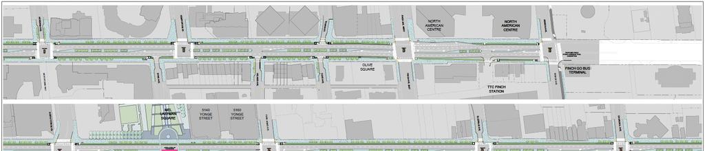
7 Attachment 6 Preliminary Preferred Design Options (Plan and Cross-Section) Stage 1 Phase of Work Yonge Street North of Sheppard (Design Option 4B): South of Sheppard (Design Option 4A):


8 Attachment 7 Alternative Solutions for Beecroft Road, Doris Avenue or both Stage 2 Phase of Work Yonge Street as well as Beecroft Road/Doris Avenue Modify Existing boulevards maintained Add bike lanes with painted buffer Maintain off-peak parking northbound on Doris Avenue and southbound on Beecroft Road

9 Transform 1 Widened boulevards where necessary Raised cycle tracks adjacent to the curb Maintain off-peak parking Trees replaced if there are impacts Public realm improvements and widened sidewalks


10 Transform 2 Widened boulevards where necessary Add bidirectional cycling path in west boulevard of Beecroft Road and/or east boulevard of Doris Avenue Maintain off-peak parking Trees replaced if there are impacts Public realm improvements and widened sidewalks


11 Transform 3 Widened boulevards where necessary Add cycling paths in boulevards Maintain off-peak parking northbound on Doris Avenue and southbound on Beecroft Road Trees replaced if there are impacts Public realm improvements and widened sidewalks

12 Attachment 8 Updated Criteria and Measures
13 Attachment 9 Evaluation of Stage 2 Alternatives (Step 1) Criterion Planning: Vision and Identity Evaluation Summary Transform 3 provides opportunities for wider sidewalks, placemaking opportunities, and reduced noise. Mobility and Congestion Management Transform 1 does not reduce traffic capacity, minimizes conflicts between user types, and provides opportunities for wider sidewalks. Walking Cycling Transform 3 provides opportunities for wider sidewalks and reduced crossing distances. Transform 1 provides separated cycle track. Minimizes user conflicts and simplifies signaling requirements. Curbside Activity Transform 1 and 2 maintain curbside access similar to existing. Parking Opportunities for Design Excellence Constructability and Utilities Natural Environment Transform 1 and 2 maintain parking conditions similar to existing. Net increase in off-peak on-street spaces is proposed for the study focus area. Transform 3 provides opportunities to expand the pedestrian realm and has the most positive effect on the scale of the street through in lane reduction. Modify preferred due to limited potential property impacts compared to the other alternatives. Shortest duration of construction. Transform 3 provides the greatest potential for additional trees and environmental design features. Cultural Heritage and Built Heritage Resources All options equally preferred due to adjacency to York Cemetery requiring additional archeological assessment. Capital Costs O&M Costs Long-Term Resilience Modify has lower anticipated capital costs relative to Transform alternatives. Modify has lower anticipated maintenance costs relative to Transform alternatives. Transform 1 and 2 balance anticipating future mode shift and adaptable on-street space.


14 Attachment 10 Evaluation of Selection of Preferred Street for Preliminary Preferred Alternative "Transform 1" (Step 2)


15 Attachment 11 Cross-Sections for the Preliminary Preferred Stage 1 and Stage 2 Alternatives
16 Attachment 12 Finch Hydro Corridor Multi-Use Trail Concept Plan
17 Attachment 13 Scenarios Modelled for Traffic Assessment Scenario Existing - serves as a baseline reference point for existing conditions Scenario preliminary preferred alternative "Transform Yonge" generally includes four lanes on Yonge Street between Sheppard Avenue and Hendon Avenue / Bishop Avenue. Assumes existing road network on Beecroft Road and Doris Avenue is maintained. Scenario "worst case" scenario for Stage 2 alternatives (Modify and Transform 3) removal of one travel lane from Beecroft Road and Doris Avenue between Sheppard Avenue and Finch Avenue. Assumes that existing road network on Yonge Street (six lanes) is maintained. Scenario Future Background (Do Nothing) - includes the existing road network including six lanes on Yonge Street and four lanes on Beecroft Road and Doris Avenue with the projected 2031 development growth Scenario preliminary preferred alternative "Transform Yonge" generally includes four lanes on Yonge Street between Sheppard Avenue and Hendon Avenue / Bishop Avenue. Assumes that the Doris Avenue extension is completed and that four lanes are maintained on each of Beecroft Road and Doris Avenue. Scenario "worst case" scenario for Stage 2 alternatives (Modify and Transform 3) removal of one travel lane from Beecroft Road and Doris Avenue between Sheppard Avenue and Finch Avenue. Assumes that the Doris Avenue extension is completed and that the existing number of lanes on Yonge Street is maintained.
18 Attachment 14 Recommendations for Mitigation of Traffic Impacts for "Transform Yonge" and "Enhance Yonge and Transform Beecroft" Alternatives 1. Improving Traffic Operations on Yonge Street Near Term (a) Maintain turn lanes at key intersections within the study focus area and remove others that offer little benefit or create operational issues. Using the results of the transportation model, changes to the following intersections are recommended: a) Yonge Street and Sheppard Avenue the heaviest demands are for the westbound left turn and north-south through movements. Northbound and southbound left turns operate with protected phases that on occasion are not used because through queues block access to the turn lanes. Removing the northbound and southbound left turn lanes will free up additional green time for east-west and north-south movements. b) Removal of northbound and southbound left-turns on Yonge Street is also recommended at the following locations (this would be implemented through the median extension): Florence Avenue / Avondale Avenue Olive Avenue / Tolman Street Norton Avenue Parkview Avenue Upper Madison (north) Avenue Harlandale Avenue Bogert Avenue Glendora Avenue c) Yonge Street and Poyntz Avenue to accommodate the removal of the northbound left turn movement at Yonge Street and Sheppard Avenue, it is recommended that the northbound left turn movement at Yonge Street and Poyntz Avenue be maintained, that the storage length for the turn lane be extended to the maximum distance possible and that a protected northbound left-turn phase be implemented to encourage motorists to use Poyntz Avenue which provides direct access to Beecroft Road. (b) Optimize signal timing plans throughout the Yonge Street corridor to move traffic more efficiently. (c) Consolidation of GO Transit Bus Stops - the number of stops will be reduced from eight (8) to five (5) which will both improve GO Transit operations and minimize the impact of loading and unloading activities on Yonge Street traffic operations.
19 (d) Provide bus bays at transit stops - the provision of bus bays in the preferred design will ensure that TTC and GO Transit buses are able to load and unload passengers without causing delays to through traffic on Yonge Street. (e) Provide a northbound bus only lane on Yonge Street between Finch Avenue and Bishop Avenue/Hendon Avenue to better accommodate the turning requirements of TTC vehicles from Finch Avenue bus terminal. The provision of the bus only lane will result in a five (5) lane cross section along this section of Yonge Street. 2. Improving Traffic Operations on the North York Service Roads Near-Term Under 2031 traffic conditions, the traffic modelling carried out shows that the North York Service Roads (Doris Avenue and Beecroft Road) are operating under capacity and that these roads can accommodate increased demands should traffic divert away from Yonge Street. A number of operational improvements are recommended to encourage this diversion as intended: (a) Extend no parking restrictions on Doris Avenue and Beecroft Road during the peak periods where applicable. Under existing conditions, parking is generally permitted on the service roads during weekday off peak periods (9:00 AM to 4:00 PM and 6:00 PM to 7:00 AM). To ensure parking permissions reflect weekday peaking characteristics, it is recommended that the peak hour restrictions on parking be extended from two to three hours during both the AM and PM peak periods. (b) Complete the Doris Avenue extension to Tradewind Avenue identified in the North York Service Road EA Addendum - Transportation Services is actively carrying out an EA Addendum for the extension of Doris Avenue south of Sheppard Avenue East. Staff are working to coordinate the implementation of the Doris Avenue extension to occur shortly after reconstruction of Yonge Street is completed. This study is on hold pending the results and completion of this EA Study. Long-Term (b) Review the need for a southbound right turn lane at Beecroft Road and Sheppard Avenue West to improve intersection operations. Under 2031 future conditions, this intersection is forecasted to operate under congested conditions. An exclusive southbound right-turn lane will prevent right-turning traffic from slowing southbound through traffic and will result in moderate overall improvements in the operation of this intersection. (d) Complete the Beecroft Road extension to Drewry Avenue - staff are working with area developers to actively plan for the extension of Beecroft Road to Drewry Avenue. This extension will further support Beecroft Road as a viable alternative to Yonge Street.
20 3. Improving Connections to/from the North York Service Roads Near-Term (a) Extend the westbound left turn lane at Yonge Street and Empress Avenue - providing additional space for westbound left-turning traffic will reduce the occurrence of westbound left-turning queues impacting westbound through and right-turning traffic. Long-Term (b) Review the need for road widenings identified in the Beecroft Extension EA to ensure sufficient capacity is available to accommodate a greater reliance on the Service Roads to travel to/from the North York Centre. East-west streets identified for widening include: Hendon Avenue from two (2) to four (4) lanes between Greenview Avenue and Doris Avenue Kenneth Avenue from two (2) to four (4) lanes between Finch Avenue and Bishop Avenue Churchill Avenue/Church Avenue from two (2) to four (4) lanes between Canterbury Place and Doris Avenue Empress Avenue from two (2) to four (4) lanes between Yonge Street and Doris Avenue

21 Attachment 15 - Proposed Parking Density for "Transform Yonge"
22 Attachment 16 Public Engagement Program and Feedback Received 1. Notice of Study Commencement A Notice of Study Commencement and Public Drop-in Event (Public Information Centre #1) was published prior to the first drop-in event in May 2016 to provide the study background, the process, details on the meeting, the project webpage address, and contact information for the City s Sr. Public Consultation Coordinator. The notice was published in the North York Mirror on May 12 and 19, Flyers announcing the Study Commencement and Public Drop-in Event were distributed by unaddressed mail through Canada Post to all properties located within the extended EA Study Area (approximately 66,000), and letters were sent via to the study mailing list. 2. Project Webpage A project webpage ( was launched to coincide with the Study Commencement notification in May 2016, and has remained active with regular updates occurring throughout the course of this study. The website provides an opportunity for the public and stakeholders to review up-todate study information and content, background information, download study materials, reports, respond to online surveys, and provides contact information for the Project Team. Additionally, all consultation events were listed on the City of Toronto's central public consultations webpage and calendar. 3. Jane s Walk May 7 th, 2016 On Saturday, May 7 th, 2016 the Project Team hosted a Jane s Walk called "REimagining Yonge Street: Your Vision for Yonge Street from Sheppard Avenue to Finch Avenue." This walk was advertised on the Jane's Walk website and notice was ed to the project mailing list and posted on the project website. The City of Toronto and members of the WSP/MMM consultant team guided approximately 20 walkers along Yonge Street, stopping to learn about planning a complete street, reliving the history of North York Centre and exploring opportunities to enhance the streetscape and public realm. The walk leader was City of Toronto Urban Designer Sasha Terry who provided a history of the area, current conditions, and plans for improvements. 4. Jane s Walk with Claude Watson Students Tuesday, May 31 st, 2016 On Tuesday, May 31 st, 2016 at 8:00am City of Toronto staff joined a group of approximately 15 students from Claude Watson School of the Arts along with one teacher to walk along Yonge Street from Spring Garden Avenue to Empress Avenue. The teacher and students led the walk, discussing elements they enjoyed and identifying areas for improvement.
23 This walk was organized in an effort to engage youth, who are key stakeholders in the study. In April 2016 the City contacted three schools in the study area with invitations to participate in student walks: Earl Haig Secondary School, Cardinal Carter Academy for the Arts, and Claude Watson School of the Arts. Claude Watson School of the Arts expressed interest and agreed to organize the walk. 5. Online and Field Survey The goal of the survey was to collect information about how the community uses Yonge Street within the study limits. The survey was designed to gather feedback about opportunities to improve Yonge Street, existing problems with the corridor, and current uses. The survey was issued to users in two (2) formats: 1) Stakeholders could complete the questionnaire by visiting the on-line survey site 2) The Project Team participated in a one-day event on May 10, 2016, surveying individuals at five (5) locations along Yonge Street during the following peak hours 11:00 a.m. 2:00 p.m.; 4:30 p.m. 6:30 p.m. and 7:30 p.m. 9:00 p.m. A total of approximately 1,084 surveys were completed. The online survey was completed by approximately 736 respondents, while 348 provided feedback during the field survey. 38% of respondents indicated that what they most like about Yonge Street is that it was well-served by transit and is convenient for walking. 46% of respondents indicated that what they least liked about Yonge Street is the poor condition of the streetscape and lack of streetscape design while 30% of respondents least liked high traffic volumes on Yonge Street. 14% and 10% of respondents indicated that lack of cycling facilities and insufficient sidewalk space is what they least like about Yonge Street. 6. Public Meetings Public drop-in events are informal meetings where area residents, interested stakeholders, businesses, and First Nations communities are provided an opportunity to review planning and project information, identify concerns and provide input to the Project Team. During this study, five (5) public drop-in events were held throughout Stage 1 and Stage 2 phases of work. The public drop-in events were arranged as drop-in sessions (openhouse style, with a series of display panels) where representatives of the Project Team were available to answer questions and discuss the study. The public drop-in events included engagement activities such as brainstorming design opportunities, voting on preferred design features, providing feedback about the alternatives, design options, evaluation criteria, and selection of the preferred alternative. 6.1 Public Drop-in Event 1 Wednesday, May 25 th, 2016 The public drop-in event was held on Wednesday, May 25, 2016, at Memorial Hall, 5110 Yonge Street, Toronto. 187 people signed in to the drop-in event. The information
24 displayed included the process involved in conducting a Municipal Class EA, the purpose of the meeting, problem / opportunity statement, existing conditions, urban design opportunities, generation of alternatives, evaluation criteria and next steps. A Notice of the first public drop-in event (together with the Notice of Study Commencement) was published in the North York Mirror on May 12 and 19, Approximately 66,000 flyers were also circulated to all properties within the expanded study area via Canada Post bulk mail on May 13, 2016, the project webpage was updated to advertise the meeting, notification was ed to the project mailing list and the event was listed on the City's central online public consultation calendar. The Notice was also provided to the offices of Councillor Filion, Councillor Shiner, Councillor Robinson, and Councillor Carmichael Greb to be shared with constituents. A range of opinions and ideas relating to opportunities to enhance Yonge Street and reimagine the street with more multimodal uses were heard by the Project Team. Some of the key information provided by residents and stakeholders prior to, during or after the public drop-in event includes support for improved pedestrian / cyclist safety, support for improved natural features (e.g. planting more trees, increased greenspace, planter maintenance, and promotion of conservation), support for wider sidewalks and general concern about lane reductions along Yonge Street and potential impact on traffic congestion. Both requests to maintain on-street parking and support to remove existing on-street parking. Bike lanes on Yonge Street were polarizing, with both strong positive and negative responses. 6.2 Design Charrette June 9, and 11th, 2016 The purpose of the charrette was to build on data gathering and analysis efforts by the Project Team to produce alternatives for a preferred design, while creating a joint vision with the community. Internal Staff / Stakeholder Session: On Thursday, June 9th the design charrette was initiated with an 'internal staff / stakeholder session at the Spring Garden Church from approximately 9:00 a.m. to 4:00 p.m. Approximately 40 people attended this session including participants from Transportation Services, City Planning, Parks, Forestry & Recreation, Major Capital Infrastructure Coordination, Public Consultation Unit, TTC and the consultant team. The internal staff / stakeholder session included various activities and peer interaction. Themes discussed included safety, sustainability, economic development, place making multimodal mobility and maintenance and implementation. Common concerns and areas for improvement identified specifically for Yonge Street included utility cuts and their potential disturbance to the public realm when emergency repairs are required, the need to improve safety and consider all modes of transportation (pedestrians, cyclists and vehicles), convenience for pedestrians and the need to add more street furniture (ie. benches, trees for shade, wayfinding, waste receptacles at regular intervals, bike parking, etc.), placemaking and identify with the community to encourage a vibrant streetscape (ie. street level patios) and transportation sustainability (ie. moving away from single-occupant vehicles).
25 Public Sessions: Day one of the design charrette was held on Thursday, June 9 th from 4:30 p.m. to 8:00 p.m. at the Spring Garden Church. 89 people signed to the June 9 th design charrette session. Day two of the design charrette was held on Saturday, June 11 from 10:00 a.m. to 1:30 p.m. at the St. George on Yonge Anglican Church. 77 people signed in to the June 11 th design charrette session. The design charrette was advertised at the Public Drop-in Event #1, the project website was updated to advertise the event, approximately 66,000 flyers were also circulated to all properties within the expanded study area via Canada Post bulk mail on May 30, 2016 and notification was ed to the project mailing list. The Notice was also provided to the offices of Councillor Filion, Councillor Shiner, Councillor Robinson, and Councillor Carmichael Greb to be shared with constituents. At the design charrette, approximately 70 attendees participated in an activity of designing a cross section along Yonge Street by using strips of paper that represented different design elements. Most people included wider sidewalks, and reduced the number of travel lanes from 6 to out of 70 (83%) of participants included a planted median in their cross-section, and 54 out of 70 (77%) of participants included bike lanes in their cross-section. Some of the key comments provided by stakeholders during or after the design charrettes include support for cycling facilities, request for more pedestrian crossing opportunities on Yonge Street, there needs to be a focus on the viability of businesses along Yonge Street throughout this study, support for the models that reference New York City, concern about maintenance of the green space, given it is not being maintained today, suggestion to add small trees and keep the existing green space, support for a landscaped median that could accommodate pedestrian crossings. 6.3 Public Drop-in Event 2 Monday, July 25th, 2016 The second public drop-in event for this study was held on Monday, July 25, Two sessions, a day and evening session were offered for Public Drop-in Event #2. The details are as follows: Day Session Stakeholders were invited to drop-in anytime from 11:00 a.m. 2:00 p.m. at Mel Lastman Square (5100 Yonge Street), where an information booth was set up in the Square and Project Team members were available to answer questions. Evening Session At North York Memorial Hall (5110 Yonge Street), stakeholders were invited to drop-in anytime from 5:00 p.m. 8:00 p.m. to view the panels and discuss with Project Team members. A Notice of the second public drop-in event was published in the North York Mirror on July 14 and 21, Due to a potential Canada Post strike, instead of a flyer
26 distribution to all properties within the extended study area, City staff held three (3) Planner in Public Spaces (PiPS) events to share information. The dates, times and locations of the PiPs events were: Monday, July 18 from 4:00 pm to 7:00 pm at Finch Subway Station Wednesday, July 20 from 12:00 pm to 7:00 pm at the Hullmark Centre Thursday, July 21 from 10:00 am to 2:00 pm at the North York Civic Centre (NYCC) Farmers Market held in Mel Lastman Square In addition, the project webpage was updated to advertise the meeting, notification was ed to the project mailing list and the event was listed on the City's central online public consultation calendar. The Notice was also provided to the offices of Councillor Filion, Councillor Shiner, Councillor Robinson, and Councillor Carmichael Greb to be shared with constituents. A total of 83 individuals signed in at this public drop-in event. Some of the key comments heard at the drop-in event and provided by residents and stakeholders after the event include, support for the preliminary preferred alternative - Transform., support for bike lanes to be included in the plan for Yonge Street, a need to consider that Yonge Street will need to be maintained to avoid it falling into disrepair, preference to avoid a six lane cross-section as this will allow more traffic, sidewalks should be wider, support of Design Option 4B as it is pedestrian friendly, concern about traffic impacts with a reduction of 6 to 4 lanes, concern about traffic operations in the Highway 401 vicinity, preference to relocate parking to other streets, support for public realm opportunities at Mel Lastman Square, support to connect the Finch Hydro Corridor multi-use trail to Yonge Street, preference to use natural paving material for sidewalks like stone or granite and the need to treat Yonge Street similarly to Bloor Street or Queens Quay. 6.4 Public Drop-in Event 3 September 29, 2016 The third public drop-in event for this study was held on September 29, 2016 in the main floor foyer of the North York Civic Centre. The information presented at this meeting included a study update, the evaluation of the design options and selection of the preferred design option, mitigation measures and next steps in the study. 64 people signed in to the Public Drop-in Event. Many others attended but chose not to sign in. A Notice advertising the public drop-in event 3 was published in the North York Mirror on September 15, A flyer was also circulated to all properties within the expanded study area via Canada Post bulk mail on September 13, 2016, and the project webpage was updated to advertise the drop-in event. Approximately 66,000 flyers were also circulated to all properties within the expanded study area via Canada Post bulk mail on May 13, 2016, the project webpage was updated to advertise the meeting, notification was ed to the project mailing list and the event was listed on the City's central online public consultation calendar. The Notice was also provided to the offices of Councillor Filion, Councillor Shiner, Councillor Robinson, and Councillor Carmichael Greb to be shared with constituents.
27 Some of the key comments heard at the drop-in event and provided by residents and stakeholders after the event include, support for the preliminary preferred Design Options 4A and 4B, some comments supporting Design Option 4F (parking bays), support for the proposed plan as it will significantly improve livability in the area, concern about maintenance of the landscaped median, concern about reducing the travel lanes on Yonge Street, concern about the removal of on-street parking on Yonge Street and impact on businesses and support for wider sidewalks on Yonge Street. 6.5 Public Drop-in Event 4 October 10, 2017 The fourth public drop-in event for this study was held on October 10, 2017 at Memorial Hall, 5110 Yonge Street, Toronto. The information presented at this meeting included a study update, the results of the evaluation of the Stage 2 alternatives and next steps in the study. Approximately 230 people attended the Public Drop-in Event. Translators were available to provide information in Korean, Chinese and Farsi and event information was translated and made available online. Notice of the event was mailed to approx. 66,000 residences and businesses and ed to approximately 750 people. Notice of the event was also advertised in the September 28, 2017 and October 5, 2017 editions of the North York Mirror (East) and posted on the project site. City staff held three (3) Planner in Public Spaces (PiPS) events to share information about the study and advertise Public Drop-in Event 4. The dates, times and locations of the PiPs events were: Thursday, August 31, 2017 from 11:00 am to 1:30 pm at the North York Civic Centre (NYCC) Farmers Market held in Mel Lastman Square Wednesday, September 6, 2017 from 4:30 pm to 6:30 pm at Finch Subway Station Wednesday, September 28, 2017 from 11:00 am to 2:00 pm at the North York Civic Centre (NYCC) Farmers Market held in Mel Lastman Square Approximately 204 responses were received via feedback forms at the meeting or online. Results showed the following: 57% preferred cycling on Beecroft Road and Doris Avenue compared with 33% preferring Beecroft Road only and 9% preferring Doris Avenue only The type of cycling facility preferred along Beecroft Road and/or Doris Avenue showed highest support for Transform 2: In-boulevard bi-directional cycling path (43%) and Transform 1: Raised cycle tracks adjacent to the curb (30%) Of the 215 respondents, preference for alternatives Stage 1 (Transform Yonge) vs Stage 2 (Enhance Yonge and Transform Beecroft) was 40% to 60% in favour of Stage Public Drop-in Event 5 December 11, 2017
28 The fifth public drop-in event for this study was held on December 11, 2017 at Memorial Hall, 5110 Yonge Street, Toronto. The information presented at this meeting included a study update, the evaluation results between the Stage 1 (Transform Yonge) and Stage 2 (Enhance Yonge and Transform Beecroft) alternative solutions and next steps in the study. Approximately 160 people attended the Public Drop-in Event. Translators were available to provide information in Korean, Chinese and Farsi and event information was translated and made available online. Notice of the event was mailed to approx. 66,000 residences and businesses and ed to approximately 750 people. Notice of the event was also advertised in the November 30, 2017 edition of the North York Mirror (East) and posted on the project site. A total of 613 responses were received to the question on whether you agree or disagree with the recommendation to Transform Yonge (includes feedback forms received at the meeting and online responses) Of the 613 responses, 89% agreed with the recommended preliminary preferred alternative Transform Yonge; 11% disagreed with the recommendation Respondents expressed interest in on-street parking being investigated for Beecroft Road (73%); Doris Avenue (67%) and other east-west streets within the Study Focus Area (35%) Of the respondents, a majority walk along Yonge Street (80%); travel by TTC (78%); and bike (62%), followed by drive (38%), taxi (11%), passenger (9%), GO (4%) 7. Design Review Panel The Design Review Panel (DRP) is set up as an advisory body to City staff. It is comprised of private sector design professionals architects, landscape architects, urban designers and engineers who provide independent, objective advice to city staff aimed at improving matters of design that affect the public realm. The Project Team met with members of the DRP on two (2) occasions for this study as further described below. May 26 th, 2016 Design Review Panel Meeting A presentation was made by members of the Project Team during the meeting. The DRP provided the following input to the Project Team: Both positive and negative comments were received about the existing median; Understanding the subsurface utilities is essential; Comments were received on the evaluation criteria, including: adding wind impacts, and focus on environmental sustainability instead of wildlife impacts; The panel provided examples of other great streets, including: Bloor Street, St. George, Michigan Avenue in Chicago; and The panel indicated that a strong graphic design is needed for Yonge Street.
29 September 15 th, 2016 Design Review Panel Meeting Members of the Project Team made a presentation to the DRP, presenting the evaluation of alternatives and the selection of the preferred planning alternative and design option. The following key points were identified by the DRP regarding the design: Panel members fully supported the proposed option for reduced vehicular lanes from 6 to 4, and noted that without this type of change, there will likely be little ability for significant improvement to the street; Concerned that the median would detract from the ability to have a truly generous pedestrian sidewalk area and a safe wide cycle track; Due to limited dimensions for this street, the project should focus on providing a "very rich sidewalk life" first and foremost; Trees struggle to survive in landscaped medians; Supported the raised dedicated cycle tracks on both sides of Yonge Street; and, Recommendations for other surface treatments at the three public spaces was discussed. 8. External Stakeholder Consultation 8.1 Project Mailing List At the onset of the study, a contact list was developed, which included municipal staff, interest groups (including Yonge Corridor Condominium Association, Silverview Community Association, Bayview Cummer Neighbourhood Association, Avondale Community Condo Association, West Lansing Homeowners Association, Federation of North Toronto Residents' Associations (FoNTRA), Lansing Community Association, Edithvale-Yonge Community Association, Willowdale West, South of Sheppard, Willowdale Centre, Walk Toronto, Canterbury Place and CycleTO), and other interested stakeholders and relevant bodies that may hold interest in the study. As the study progressed, the contact list was updated to ensure that all identified interested parties received study notifications. Interested individuals could add themselves to the project mailing list online, via phone, or at a consultation event. It should be noted that there is no business improvement association in the Study Focus Area. City staff met with business leaders during the project in order to inform them of the study. The Planners in Public Spaces events were also intended partially as an outreach to the business community. 8.2 Agencies Federal and Provincial agencies, school boards and utility service providers were notified at the beginning of the study informing them of the study and soliciting their comments. Individuals and groups that expressed an interest in the project were kept informed throughout the study and were invited to attend the public drop-in events.
30 8.3 Aboriginal Community Engagement First Nations communities and the Ministry of Aboriginal Affairs were contacted by the Project Team at key milestones throughout the study process. 8.4 Business Owners Door-to-Door Visits City staff visited local businesses and property managers located within the Study Focus Area on May 17, 18 and 19, All businesses received a project postcard and were asked for their contact information and how they would like to get involved. Survey of Local Businesses and Property Managers A letter and survey were issued through Canada Post on August 10, 2017 to 161 businesses and property management firms within the study area asking for their input on the priorities for REimagining Yonge (Sheppard to Finch) EA Study, what improvements they wanted to see, and how they wanted to be engaged in the study. A copy of the letter was also issued on August 15, 2017 to businesses on the distribution list. Deadline to complete the survey was August 25, The survey was made available in hard copy (with postage paid envelope provided for return) and on-line. The City received 23 surveys responses. Respondents indicated that addressing traffic congestion on Yonge Street, Doris Avenue and Beecroft Road was a top priority. On Yonge Street, parking and sidewalk space, followed by streetscape design and patio space were important elements. On Doris Avenue, parking, sidewalk space for pedestrians and cycling facilities are priorities. On Beecroft Road, cycling facilities and sidewalk space featured as priorities. Local Business Meetings A series of meetings were held to provide area businesses an opportunity to find out more about the study, meet with City staff and ask questions about the work completed. Events were held on: o October 5, 2017 (8:00 10:00 a.m.) o October 16, 2017 (6:00 8:00 p.m.) o December 14, 2017 (8:00 10:00 a.m.) For each event, a letter was mailed to all businesses in the Study Focus Area, in advance of the meeting date and a series of follow-up s were issued to promote the events. A copy of the letter and survey were translated into Korean, Chinese and Farsi and issued in the follow-up s. One representative of an area business attended the October 16 th meeting and 12 business representatives attended the December 14 th meeting. The main concerns voiced were the impact on traffic conditions along Yonge Street, loss of parking along Yonge Street, poor sidewalk conditions and the suggestion that a pilot study be undertaken to assess the traffic impacts before the study is completed. 8.5 Resident and Ratepayer Associations
31 Staff attended a meeting, hosted by Councillor Filion, with the Yonge Corridor Condo Association (YCCA) on September 13, Staff presented the status of the study and answered questions from residents. A meeting was offered to 15 resident and ratepayer associations in the study area. Event was held on October 18, 2017 (6:00 8:00 p.m.) Two representatives attended; Yonge Corridor Condo Association and Willowdale Central Ratepayers Association. Comments expressed included that cyclists in condo buildings are in favour of increasing cycling opportunities and that many cyclists currently choose Beecroft Road or Doris Avenue instead of Yonge Street due to safety concerns, but that if there was a safe route along Yonge Street cyclists would use it. Suggestion made to test cycling facilities on Yonge Street through a pilot project. It was noted that within the community, there are mixed views on the alternative solutions and that more parks and open spaces may be more appealing to condo dwellers than to those with backyards. Concern was expressed that the removal of traffic lanes on Yonge Street could worsen congestion, especially southbound in the vicinity of Highway 401 In terms of parking on Yonge Street, comments noted were that part-time, on-street parking spaces alone do not support businesses on Yonge Street, and that much of their business comes from people who walk, cycle, or take transit
REimagining Yonge (Sheppard to Finch) Municipal Class Environmental Assessment Study
 Municipal Class Environmental Assessment Study") PW26.6 REPORT FOR ACTION REimagining Yonge (Sheppard to Finch) Municipal Class Environmental Assessment Study Date: January 5, 2018 To: Public Works and Infrastructure Committee From: General Manager,
PW26.6 REPORT FOR ACTION REimagining Yonge (Sheppard to Finch) Municipal Class Environmental Assessment Study Date: January 5, 2018 To: Public Works and Infrastructure Committee From: General Manager,
Interim Project Status Update - REimagining Yonge (Sheppard to Finch) Municipal Class Environmental Assessment Study
 Municipal Class Environmental Assessment Study") PW21.9 REPORT FOR ACTION Interim Project Status Update - REimagining Yonge (Sheppard to Finch) Municipal Class Environmental Assessment Study Date: April 25, 2017 To: Public Works and Infrastructure Committee
PW21.9 REPORT FOR ACTION Interim Project Status Update - REimagining Yonge (Sheppard to Finch) Municipal Class Environmental Assessment Study Date: April 25, 2017 To: Public Works and Infrastructure Committee
REIMAGINING YONGE STREET SHEPPARD AVENUE TO FINCH AVENUE
 REIMAGINING YONGE TREET HEPPARD AVENUE TO FINCH AVENUE ource: Bing Maps ENVIRONMENTAL AEMENT TUDY PUBLIC DROP IN EVENT 4 OCTOBER 10, 2017 REimagining Yonge treet 1 INTRODUCTION This study began in 2016.
WELCOME TO OPEN HOUSE # 1 June 14, 2017
 Langstaff Road Weston Road to Highway 7 Class Environmental Assessment Study WELCOME TO OPEN HOUSE # 1 June 14, 2017 Please sign in and join our mailing list Purpose of Open House #1 & Study Area York
WELCOME. Purpose of the Open House. Update you on the project. Present a draft recommended plan. Receive your input
 WELCOME Purpose of the Open House The Town of Smiths Falls has initiated the Beckwith Street Redevelopment Plan that includes the preparation of a streetscape functional design for the renewal of Beckwith
Transportation Master Plan Advisory Task Force
 Transportation Master Plan Advisory Task Force Network Alternatives & Phasing Strategy February 2016 BACKGROUND Table of Contents BACKGROUND Purpose & Introduction 2 Linking the TMP to Key Council Approved
University of Victoria Campus Cycling Plan Terms of Reference. 1.0 Project Description
 University of Victoria Campus Cycling Plan Terms of Reference 1.0 Project Description The Campus Cycling Plan, a first for the University, will provide a comprehensive and coordinated approach to support
Tonight is for you. Learn everything you can. Share all your ideas.
 Strathcona Neighbourhood Renewal Draft Concept Design Tonight is for you. Learn everything you can. Share all your ideas. What is Neighbourhood Renewal? Creating a design with you for your neighbourhood.
PROPOSED BYLAW UPDATES AND FEES FOR SIDEWALK CAFÉS & MARKETING DISPLAYS
 Transportation Services Municipal Licensing and Standards PROPOSED BYLAW UPDATES AND FEES FOR SIDEWALK CAFÉS & MARKETING DISPLAYS PUBLIC CONSULTATIONS June 13, 2017 Toronto City Hall June 20, 2017 North
AIRPORT ROAD ENVIRONMENTAL ASSESSMENT
 WELCOME TO PUBLIC INFORMATION CENTRE #1 AIRPORT ROAD ENVIRONMENTAL ASSESSMENT From Braydon Boulevard/Stonecrest Drive to Countryside Drive November 23, 2017 6:30 PM 8:30 PM Please sign in and fill out
Road Alterations - Wellington Street East, Church Street, and Front Street Intersection
 REPORT FOR ACTION Road Alterations - Wellington Street, Church Street, and Front Street Intersection Date: November 1, 2016 To: Toronto and York Community Council From: Director, Public Realm Section,
Welcome to the Open House
 Leslie Street Between 19 th Avenue and Stouffville Road Addendum to Class Environmental Assessment Study Welcome to the Open House Please sign in at the front desk. March 28, 2017 Richmond Green Sports
REIMAGINING YONGE STREET CLASS ENVIRONMENTAL ASSESSMENT
 REIMAGINING YONGE STREET CLASS ENVIRONMENTAL ASSESSMENT ORGANIZATION BEING NOMINATED: City of Toronto Transportation Services 100 Queen Street West, 24th Floor Toronto, ON M5H 2N2 Contact: Jeff Dea, Manager,
A CHANGING CITY. of Edmonton, it is essential that it reflects the long-term vision of the City.
 A CHANGING CITY By the year 2040, Edmonton will be home to more than 1 million people. To accommodate growth and support a healthy and compact city, we need a new approach to development/redevelopment
EXECUTIVE SUMMARY OF CALEDON TRANSPORTATION NEEDS STUDY
 EXECUTIVE SUMMARY OF CALEDON TRANSPORTATION NEEDS STUDY The Caledon Transportation Needs Study has been undertaken as a joint project by the Town of Caledon and the Region of Peel to determine the existing
to the Public Information Centre for the Downtown Traffic Study
 to the Public Information Centre for the Downtown Traffic Study City of Sault Ste. Marie July 25, 2018 Purpose of Study Determine if changes to one-way corridors can enhance downtown s character and spaces
Transportation Assessment
 Transportation Assessment Midtown Open House February 10, 2018 Overview Midtown in Focus Overview & Purpose of Today Transportation Assessment overview Summary of Transportation work to date Review & Analysis
Welcome. If you have any questions or comments on the project, please contact:
 Welcome This drop-in public open house is intended to provide information about the Bay Street bike lanes project. This project proposes a dedicated cycling facility along Bay Street between Aberdeen Avenue
Tonight is an opportunity to learn about the Study and ask questions of the Study Team members.
 Exhibit 1 Welcome Second Open House Tonight is an opportunity to learn about the Study and ask questions of the Study Team members. A first Public Open House was held on September 18th, 2013 which presented
Welcome to the Public Meeting. Red Hill Business Park South Transportation Master Plan Addendum. December 4, :00 p.m. to 8:00 p.m.
 Welcome Welcome to the Transportation Master Plan Addendum December 4, 2012 6:00 p.m. to 8:00 p.m. Please sign-in Background PIC#1 Public Information Centre #1 (PIC#1) was held on June 25, 2012. Feedback
Terwillegar Drive Expressway Draft Concept Plan
 Terwillegar Drive Expressway Draft Concept Plan Anthony Henday Drive to Whitemud Drive November 28 5:00-8:00 p.m. December 1 10:00 a.m. - 3:00 p.m. Let s Talk Today you can: Learn about the new direction
APPENDIX 2 LAKESHORE ROAD TRANSPORTATION REVIEW STUDY EXECUTIVE SUMMARY
 APPENDIX 2 LAKESHORE ROAD TRANSPORTATION REVIEW STUDY EXECUTIVE SUMMARY Appendix 2 City of Mississauga Lakeshore Road FINAL REPORT Transportation Review Study December 2010 EXECUTIVE SUMMARY Study Purpose
Municipal Class EA To Address Traffic Congestion On The Ontario Street Corridor (Grand Bend) Public Information Meeting June 4, 2018
 Public Information Meeting June 4, 2018") Municipal Class EA To Address Traffic Congestion On The Ontario Street Corridor (Grand Bend) Public Information Meeting June 4, 2018 Background Agenda Traffic Study Update Class EA Alternatives Bridge
Municipal Class EA To Address Traffic Congestion On The Ontario Street Corridor (Grand Bend) Public Information Meeting June 4, 2018 Background Agenda Traffic Study Update Class EA Alternatives Bridge
Richmond-Adelaide Cycle Tracks
 Public Drop-In Event Richmond-Adelaide Cycle Tracks June 25, 2018 12:00 p.m. 3:00 p.m. 4:30 p.m. 7:30 p.m. Metro Hall, Rotunda 55 John Street 1 Purpose of Event In Scope Communicate an update about the
TRANSPORTATION NEEDS ASSESSMENT
 TRANSPORTATION NEEDS ASSESSMENT A travel demand analysis was carried out to determine the operational issues and the potential benefit that adding traffic capacity would have on the road network. All the
102 Avenue Corridor Review
 February 26, 2015 102 Avenue Corridor Review Transportation Association of Canada Road Safety Engineering Award Submission for the City of Edmonton Introduction Transportation Association of Canada Road
122 Avenue: 107 Street to Fort Road
 : 107 Street to Fort Road November 24, 2015 4:30 8:00 p.m. Meeting Purpose Summarize project work completed to date Share results of public input from Phase 1 Share the draft concept plan and proposed
Climate Change Action Plan: Transportation Sector Discussion Paper: Cycling
 Climate Change Action Plan: Transportation Sector Discussion Paper: Cycling ontario.ca/climatechange Contents 1. Minister of Transportation s message... 3 2. Introduction... 5 3. Sector Overview and Support
CITY OF VAUGHAN EXTRACT FROM COUNCIL MEETING MINUTES OF OCTOBER 30, 2012
 CITY OF VAUGHAN EXTRACT FROM COUNCIL MEETING MINUTES OF OCTOBER 30, 2012 Item 31, Report No. 39, of the Committee of the Whole, which was adopted without amendment by the Council of the City of Vaughan
COUNCIL POLICY NAME: COUNCIL REFERENCE: 06/119 06/377 09/1C 10llC 12/1C INDEX REFERENCE: POLICY BACKGROUND
 COUNCIL POLICY NAME: COUNCIL ADVISORY COMMITTEES - TERMS OF REFERENCE ISSUED: APRIL 3, 2006 AMENDED: NOVEMBER 27, 2006 NOVEMBER 23, 2009 JANUARY 11, 2010 DECEMBER 17, 2012 POLICY COUNCIL REFERENCE: 06/119
Pennsylvania Avenue (CR 484) Design Alternatives Study
 Design Alternatives Study") MEMORANDUM Pennsylvania Avenue (CR 484) Design Alternatives Study Prepared for: APRIL 2016 Prepared By TABLE OF CONTENTS Project Background... 2 Previous Concept... 2 Existing Conditions... 4 New Alternatives...
MEMORANDUM Pennsylvania Avenue (CR 484) Design Alternatives Study Prepared for: APRIL 2016 Prepared By TABLE OF CONTENTS Project Background... 2 Previous Concept... 2 Existing Conditions... 4 New Alternatives...
CITY OF OTTAWA ROADWAY MODIFICATION APPROVAL UNDER DELEGATED AUTHORITY
 RMA-2015-ATM-038 CITY OF OTTAWA ROADWAY MODIFICATION APPROVAL UNDER DELEGATED AUTHORITY DATE: April 22, 2015 SUBJECT Approval of Roadway Modifications Recommended through an Area Traffic Management Study
York Region Population and Employment Growth
 March 1, 2016 1 York Region Population and Employment Growth York Region needs to comply with The Provincial Growth Plan and new forecasts introduced to 2036 and 2041 2 Regional Official Plan Review York
SAN FRANCISCO MUNICIPAL TRANSPORTATION AGENCY
 THIS PRINT COVERS CALENDAR ITEM NO. : 11 DIVISION: Sustainable Streets BRIEF DESCRIPTION: SAN FRANCISCO MUNICIPAL TRANSPORTATION AGENCY Approving traffic modifications on Twin Peaks Boulevard between Christmas
Highway 56 Traffic Study Rymal Road to Cemetery Road
 January 31, 2018 6:00 pm 8:00 pm Highway 56 Traffic Study Rymal Road to Cemetery Road City of Hamilton Public Meeting 2 2 Purpose of Public Meeting To review and obtain public input and comments on the
Report Purpose To seek Council s approval of the Wye Road Functional Planning Study (January 2015).
.") COUNCIL MEETING Meeting Date: March 10, 2015 Agenda Item #: 13.1 Wye Road Functional Planning Study (January 2015) Report Purpose To seek Council s approval of the Wye Road Functional Planning Study (January
COUNCIL MEETING Meeting Date: March 10, 2015 Agenda Item #: 13.1 Wye Road Functional Planning Study (January 2015) Report Purpose To seek Council s approval of the Wye Road Functional Planning Study (January
Complete Streets. Designing Streets for Everyone. Sarnia
 Complete Streets Designing Streets for Everyone Sarnia Complete Streets ~ Sarnia ~ 2018 Introduction Our City is made up of a network of streets that we use to go for a walk, cycle to work, drive to the
Public Event 1 Community Workshops
 Public Event 1 Community Workshops Nov. 24 & Dec. 3, 2016 Welcome Workshop Purpose We re looking to you for ideas and insights to help guide future transportation infrastructure planning in the Park Lawn
City of Hamilton s Transportation Master Plan (TMP) Public Consultation 3 December 2015
 Public Consultation 3 December 2015") City of Hamilton s Transportation Master Plan (TMP) Public Consultation 3 December 2015 McPhail Transportation Planning Services Ltd. AGENDA 6:00 7:00 pm Viewing Boards / Q & A with the Team 7:00 7:50
City of Hamilton s Transportation Master Plan (TMP) Public Consultation 3 December 2015 McPhail Transportation Planning Services Ltd. AGENDA 6:00 7:00 pm Viewing Boards / Q & A with the Team 7:00 7:50
CITY OF COCOA BEACH 2025 COMPREHENSIVE PLAN. Section VIII Mobility Element Goals, Objectives, and Policies
 CITY OF COCOA BEACH 2025 COMPREHENSIVE PLAN Section VIII Mobility Element Goals, Objectives, and Policies Adopted August 6, 2015 by Ordinance No. 1591 VIII MOBILITY ELEMENT Table of Contents Page Number
Classification Criteria
 SCHEDULE D TO RECOMMENDED OFFICIAL PLAN AMENDMENT NO. 40 SCHEDULE C-4 Road Criteria Criteria Traffic Service Objective Land Service/Access Typical Daily Traffic Volume Flow characteristics Travel Speed
Proposed. City of Grand Junction Complete Streets Policy. Exhibit 10
 Proposed City of Grand Junction Complete Streets Policy Exhibit 10 1 City of Grand Junction Complete Streets Policy Vision: The Complete Streets Vision is to develop a safe, efficient, and reliable travel
Welcome. Background. Goals. Vision
 Welcome The formal Public Information Centre (PIC) for the Transportation Master Plan How We GO will be held in early 2017. At that time we will present the recommended transportation system for Niagara
Durham Region Long Term Transit Strategy
 Durham Region Long Term Transit Strategy An adaptive, safe, reliable, frequent, accessible and desirable transit system that shapes and connects Durham Region and beyond in an economically and environmentally
North Shore Transportation Improvement Strategy
 North Shore Transportation Improvement Strategy Preliminary, Near-term Recommendation 2016 April Transportation Improvement Strategy (TIS) Comprehensive and Analytical A multi-modal transportation strategy
Evaluation and Changes to Pedestrian Priority Phase Signal (Scramble Crossing) at Bay Street and Bloor Street
 at Bay Street and Bloor Street") PW2.2 STAFF REPORT ACTION REQUIRED Evaluation and Changes to Pedestrian Priority Phase Signal (Scramble Crossing) at Bay Street and Bloor Street Date: February 12, 2015 To: From: Public Works and Infrastructure
PW2.2 STAFF REPORT ACTION REQUIRED Evaluation and Changes to Pedestrian Priority Phase Signal (Scramble Crossing) at Bay Street and Bloor Street Date: February 12, 2015 To: From: Public Works and Infrastructure
Chapter 7. Transportation. Transportation Road Network Plan Transit Cyclists Pedestrians Multi-Use and Equestrian Trails
 Chapter 7 Transportation Transportation Road Network Plan Transit Cyclists Pedestrians Multi-Use and Equestrian Trails 7.1 TRANSPORTATION BACKGROUND The District of Maple Ridge faces a number of unique
APPENDIX A: Complete Streets Checklist DRAFT NOVEMBER 2016
 APPENDIX A: Complete Streets Checklist DRAFT NOVEMBER 2016 Complete Streets Checklist MetroPlan Orlando s Complete Streets Checklist is an internal planning tool for staff to further implementation of
Markham Sports, Entertainment and Cultural Centre Transportation Overview
 Markham Sports, Entertainment and Cultural Centre Transportation Overview ARENA LOCATION 2 3 TRANSPORTATION VISION IN MARKHAM On April 12, 2011, Markham Council adopted a long-term Transportation Vision
Purpose: Financial Implications and Impact Statement: It is estimated that the cost to implement:
 Various Modifications Lower Jarvis Street and Lake Shore Boulevard East; Lower Jarvis Street, east side, between Lake Shore Boulevard East and The Esplanade - 45-77 Lower Jarvis Street; and Lower Jarvis
Living Streets Policy
 Living Streets Policy Introduction Living streets balance the needs of motorists, bicyclists, pedestrians and transit riders in ways that promote safety and convenience, enhance community identity, create
Exhibit 1 PLANNING COMMISSION AGENDA ITEM
 Exhibit 1 PLANNING COMMISSION AGENDA ITEM Project Name: Grand Junction Circulation Plan Grand Junction Complete Streets Policy Applicant: City of Grand Junction Representative: David Thornton Address:
4 DISRUPTION MANAGEMENT PLAN HIGHWAY 7 RAPIDWAY CONSTRUCTION BETWEEN BAYVIEW AVENUE AND WARDEN AVENUE TOWNS OF MARKHAM AND RICHMOND HILL
 4 DISRUPTION MANAGEMENT PLAN HIGHWAY 7 RAPIDWAY CONSTRUCTION BETWEEN BAYVIEW AVENUE AND WARDEN AVENUE TOWNS OF MARKHAM AND RICHMOND HILL The Transportation Services Committee recommends the adoption of
WALK CYCLE MOVE. Active Transportation Demonstration Projects. Toronto Public Health Final Report
 WALK CYCLE MOVE Active Transportation Demonstration Projects Toronto Public Health Final Report Prepared by Gladki Planning Associates and Moving Right Along May 2014 This page has been intentionally left
NORTH YORK CENTRE Mobility Hub Profile
 Mobility Hub Profile Dundas North York West-Bloor Centre Anchor Hub Gateway Hub N MOBILITY HUBS: Places of connectivity between regional and rapid transit services, where different modes of transportation
Main-McVay Transit Study: Phase 2 Options Definition and High Level Constraints Evaluation
 Main-McVay Transit Study: Phase 2 Options Definition and High Level Constraints Evaluation APRIL 2016 A collaborative study between: For Additional Information or to Comment If you would like additional
Toronto and East York Community Council. Director, Transportation Services, Toronto and East York District
 No Turn on Red Regulations STAFF REPORT ACTION REQUIRED Date: June 1, 2010 To: From: Toronto and East York Community Council Director, Transportation Services, Toronto and East York District Wards: Trinity
Light Rail Transit in North Central Calgary Open House and Workshop Summary. Summer 2013
 Light Rail Transit in North Central Calgary Open House and Workshop Summary Summer 2013 Engaging Calgarians on NC LRT The City of Calgary is working to improve transportation choices that will connect
Prepared For: Shieldbay Developments Inc. c/o Matson, McConnell Ltd. 2430A Bloor Street West Toronto, Ontario M6S 1P9.
 Prepared For: Shieldbay Developments Inc. c/o Matson, McConnell Ltd. 2430A Bloor Street West Toronto, Ontario M6S 1P9 Prepared By: URS Canada Inc. 4 th Floor, 30 Leek Crescent Richmond Hill, Ontario L4B
ALBERTA AVENUE WHAT WE HEARD REPORT BUILDING GREAT NEIGHBOURHOODS
 ALBERTA AVENUE WHAT WE HEARD REPORT BUILDING GREAT NEIGHBOURHOODS FEBRUARY 2019 EXECUTIVE SUMMARY Starting in 2019, Alberta Avenue will see the replacement and enhancement of its aging collector and local
NEWMARKET UPHAM S CORNER
 SOUTH STATION Planning Initiative NEWMARKET UPHAM S CORNER COLUMBIA ROAD (P) FOUR CORNERS/GENEVA Working Advisory Group (WAG) Meeting #5 TALBOT AVENUE MORTON STREET BLUE HILL AVE/CUMMINS HWY (P) RIVER
Appendix B Workshop Materials
 Appendix B Workshop Materials Public Event 1 Community Workshops Nov. 24 & Dec. 3, 2016 Welcome Workshop Purpose We re looking to you for ideas and insights to help guide future transportation infrastructure
Why invest in the 1 Street S.W. Corridor?
 Why invest in the 1 Street S.W. Corridor? This project is an investment in the Beltline Community and Calgary s economy. It is anticipated that The City s investment along this corridor will help with
Welcome. The Brooklin Secondary Plan and Transportation Master Plan are collectively referred to as the Brooklin Study.
 Welcome The Town of Whitby is undertaking a study to prepare a Secondary Plan and Transportation Master Plan to guide and manage growth in the Brooklin area. The Brooklin Secondary Plan and Transportation
2014/2015 BIKE ROUTE PLAN 83 AVENUE PROTECTED BIKE LANE
 About the Project 2014/2015 BIKE ROUTE PLAN The City of Edmonton is planning a major bike route on the south side of Edmonton. This bike route is one part of a plan to provide citizens with transportation
Public Works and Infrastructure Committee. General Manager, Transportation Services
 STAFF REPORT ACTION REQUIRED Extending the Bay Street Bicycle Lanes Date: May 16, 2013 To: From: Public Works and Infrastructure Committee General Manager, Transportation Services Wards: Toronto Centre
City of Wilsonville 5 th Street to Kinsman Road Extension Project
 City of Wilsonville 5 th Street to Kinsman Road Walking Tour & Neighborhood Workshop Summary Report Public Outreach Overview On July 18 th, 2017, the City of Wilsonville hosted a neighborhood walking tour
WEST AND SOUTH WEST RING ROAD DOWNSTREAM TRAFFIC IMPACTS
 Page 1 of 9 EXECUTIVE SUMMARY Alberta Transportation ( AT ) is preparing to construct the final sections of the Calgary Ring Road. This includes the South West Ring Road ( SWRR ) (from Lott Creek Blvd
Chapter 2. Bellingham Bicycle Master Plan Chapter 2: Policies and Actions
 Chapter 2 Bellingham Bicycle Master Plan Chapter 2: Policies and Actions Chapter 2: Policies and Actions The Bicycle Master Plan provides a road map for making bicycling in Bellingham a viable transportation
Solana Beach Comprehensive Active Transportation Strategy (CATS)
") Solana Beach Comprehensive Active Transportation Strategy (CATS) 3.0 Goals & Policies The Solana Beach CATS goals and objectives outlined below were largely drawn from the Solana Beach Circulation Element
Solana Beach Comprehensive Active Transportation Strategy (CATS) 3.0 Goals & Policies The Solana Beach CATS goals and objectives outlined below were largely drawn from the Solana Beach Circulation Element
We support the following: Tom Davies Square 200 Brady Street Sudbury, Ontario
 April 4, 2014 Tom Davies Square 200 Brady Street Sudbury, Ontario RE: Second Avenue Reconstruction Project and Panel Consultation Dear City of Greater Sudbury Mayor and Council: The (SMAP), a council appointment
Moving Cambridge. City of Cambridge Transportation Master Plan Public Consultation Centre. March 7, :00 8:00 PM.
 City of Cambridge Transportation Master Plan Public Consultation Centre March 7, 2018 5:00 8:00 PM Region of Waterloo City of Cambridge Transportation Master Plan Public Consultation Centre March 7, 2018
Proposed Bridge Street East Bicycle Lanes Public Open House Thursday, April 27, 2017
 WELCOME Proposed Bridge Street East Bicycle Lanes Public Open House Thursday, April 27, 2017 Purpose of the Open House The purpose of this Open House is to gain public input on the bicycle lanes proposed
Harbord Street and Hoskin Avenue Bicycle Lane Upgrades
 STAFF REPORT ACTION REQUIRED and Bicycle Lane Upgrades Date: April 22, 2014 To: From: Wards: Reference Number: Public Works and Infrastructure Committee General Manager, Transportation Services 19 and
Environment and Public Works Committee Presentation
 Mixed Use Centers Complete Streets Guidelines Project Environment and Public Works Committee Presentation December 10, 2008 Project Objectives: Conduct an inter-departmental and agency process to study
Bloor Street Design Feasibility Study and Bike Lane Pilot Project. Public Works and Infrastructure Committee
 PW12.1 STAFF REPORT ACTION REQUIRED Design Feasibility Study and Bike Lane Pilot Project Date: March 30, 2016 To: From: Wards: Reference Number: Public Works and Infrastructure Committee General Manager,
Preliminary Transportation Analysis
 Preliminary Transportation Analysis Goals of a Robust, Multimodal Transportation Network Safe Accessible/Connected Efficient Comfortable Context-Sensitive Motor Vehicle: Continue to analyze the data to
Sixth Line Development - Transit Facilities Plan
 Memorandum Date: November 13, 2012 To: From: c.c. Subject: Rob Freeman (Freeman Planning) Kevin Phillips Sixth Line Development - Transit Facilities Plan 33016631 This memo was prepared to review the transit
Major Bike Routes 102 Avenue Workshop April 21, 2015
 Major Bike Routes 102 Avenue Workshop April 21, 2015 Our Purpose Today Provide context on how Major Bike Routes fit into Edmonton s future Share information on what we heard in our last phase, and how
Princeton Avenue and Spruce Street Transportation and Site Access Enhancements Project
 Princeton Avenue and Spruce Street Transportation and Site Access Enhancements Project Mercer County Planning Division AECOM Transportation (formerly DMJM Harris) January 29, 2009 Agenda Project Status
Eastern PA Trail Summit October 1, 2018
 Eastern PA Trail Summit October 1, 2018 WHO WE ARE + WHY + WE RE * HERE * * * * * * Session Goals: Discuss how to coordinate planning and design in small, urbanized towns Consider how to develop alternative
Shifting Gears for a Healthier City
 Shifting Gears for a Healthier City Mississauga s Cycling Master Plan is an ambitious strategy that sets out to transform Mississauga into a city that is conducive to cycling for daily transportation needs.
FOLSOM-HOWARD STREETSCAPE OVERVIEW
 FOLSOM-HOWARD STREETSCAPE OVERVIEW SoMa residents should have the same kinds of amenities that other neighborhoods have. The Folsom- Howard Streetscape Project will make SoMa more livable by making it
OTM Book 18 Cycling Facilities Update
 OTM Book 18 Cycling Facilities Update Wednesday, April 18 th, 2018 Ontario Bike Summit Cycling Design Concurrent Session WITH INASSOCIATION WITH Today s Discussion Point 1. Why is Book 18 being updated?
Outreach Approach RENEW SF served as the primary liaison with the North Beach community; the Chinatown. Executive Summary
 Executive Summary Executive Summary The Columbus Avenue Neighborhood Transportation Study s objective is to identify changes to transportation infrastructure and policies that could enhance the livability
Wyldewood Estates. Pre-Application Public Engagement Summary of Issues and Responses
 Wyldewood Estates Pre-Application Public Engagement Summary of Issues and Responses March 2016 Executive Summary Morguard Residential Properties has been thoughtfully planning the redevelopment of Wyldewood
2. NORTEL CARLING CAMPUS EXPANSION - PROPOSED MODIFICATIONS TO MOODIE DRIVE (REGIONAL ROAD 59) AND HIGHWAY 417 INTERCHANGE
 AND HIGHWAY 417 INTERCHANGE") 2. NORTEL CARLING CAMPUS EXPANSION - PROPOSED MODIFICATIONS TO MOODIE DRIVE (REGIONAL ROAD 59) AND HIGHWAY 417 INTERCHANGE COMMITTEE RECOMMENDATIONS AS AMENDED That Council approve: 1. The endorsement
2. NORTEL CARLING CAMPUS EXPANSION - PROPOSED MODIFICATIONS TO MOODIE DRIVE (REGIONAL ROAD 59) AND HIGHWAY 417 INTERCHANGE COMMITTEE RECOMMENDATIONS AS AMENDED That Council approve: 1. The endorsement
Corporate. Report COUNCIL DATE: June 26, 2006 NO: C012 COUNCIL-IN-COMMITTEE. TO: Mayor & Council DATE: June 22, 2006
 Corporate NO: C012 Report COUNCIL DATE: June 26, 2006 COUNCIL-IN-COMMITTEE TO: Mayor & Council DATE: June 22, 2006 FROM: General Manager, Engineering FILE: 0410-20(MoT/Gate) SUBJECT: Surrey Response on
WELCOME! To the Centennial Neighbourhoods Secondary Plan and Transportation Management Plan Information Centre. City of Hamilton
 WELCOME! To the Centennial Neighbourhoods Secondary Plan and Transportation Management Plan Information Centre City of Hamilton Public Information Centre #2 Dec 1, 2015 CENTENNIAL NEIGHBOURHOODS SECONDARY
Lee s Summit Road Improvement Study Public Open House June 7, 2007 Summary of Comment Card Responses
 Lee s Summit Road Improvement Study Public Open House June 7, 2007 Summary of Comment Card Responses Introduction At the Lee s Summit Road Improvement Study Public Open House held Thursday, June 7, 2007
Saskatchewan Drive Roadway Rehabilitation and Shared-Use Path Widening
 Saskatchewan Drive Roadway Rehabilitation and Shared-Use Path Widening We are here today to present the draft plan for the Saskatchewan Drive Roadway Rehabilitation and Shared-Use Path Widening project
8 PROPOSED ROUNDABOUT DUFFERIN STREET AND KING VAUGHAN ROAD INTERSECTION CITY OF VAUGHAN
 8 PROPOSED ROUNDABOUT DUFFERIN STREET AND KING VAUGHAN ROAD INTERSECTION CITY OF VAUGHAN The Transportation Services Committee recommends the adoption of the recommendation contained in the following report
REGIONAL BICYCLE AND PEDESTRIAN DESIGN GUIDELINES
 REGIONAL BICYCLE AND PEDESTRIAN DESIGN GUIDELINES November 16, 2011 Deb Humphreys North Central Texas Council of Governments Bicycle and Pedestrian Advisory Committee Snapshot of the Guide 1. Introduction
Byron Avenue. Public Meeting. Thursday June 16, Traffic Calming Design Sherbourne Road to Island Park Drive
 Byron Avenue Traffic Calming Design Sherbourne Road to Island Park Drive Public Meeting Thursday June 16, 2016 Our Lady of Fatima Parish 153 Woodroffe Avenue 6 9pm 1 Project Summary Area Projects Background
Richmond-Adelaide Cycle Track Study Including Peter Street & Simcoe Street
 Richmond-Adelaide Cycle Track Study Including Peter Street & Simcoe Street Information Booklet #2 DRAFT November 5, 2013 Richmond St. west of University Ave. Table of Contents BACKGROUND... 3 WHAT S NEW
Zlatko Krstulich, P.Eng. City of O9awa
 Zlatko Krstulich, P.Eng. City of O9awa 1. Introduction to the Ontario Traffic Manual Series 2. What is OTM Book 18: Bicycle Facilities? 3. Study / Committee Team Members 4. Brief overview of the content
MAG Town of Cave Creek Bike Study Task 6 Executive Summary and Regional Significance Report
 Page 1 MAG Town of Cave Creek Bike Study Task 6 Executive Summary and Regional Significance Report August 1, 2012 MAG Project #481 Page 2 Task 6 Executive Summary and Regional Significance Report Introduction
Service Business Plan
 Service Business Plan Service Name Transportation Planning Service Type Public Service Owner Name Kaylan Edgcumbe Budget Year 2019 Service Owner Title Service Description Manager of Transportation Planning
Executive Summary Route 30 Corridor Master Plan
 Route Corridor Master Plan Project Overview The Route Corridor Master Plan is a coordinated multimodal transportation and land use plan for the entire stretch of Route through East Whiteland Township,
Comments The Plan for Port Whitby
 Comments The Plan for Port Whitby April 24th, 2013 Community Meeting #2 Summary Report Prepared by GLPi April 29th, 2013 1 Introduction The purpose of the Port Whitby Secondary Plan Update, Community Improvement