PACK CREEK KAYAK RENTAL
|
|
|
- Allan Snow
- 6 years ago
- Views:
Transcription


1 Above and Beyond Alaska, LLC PACK CREEK KAYAK RENTAL CLIENT INFORMATION PACKET Pack Creek Tideflat Brown Bear Windfall Harbor Above and Beyond Alaska, LLC Juneau, AK
2 TABLE OF CONTENTS INTRODUCTION... Pg. 2 PACK CREEK GENERAL INFORMATION About.... Pg. 2 Permits... Pg. 3 Visitor Rules Pg. 3 CAMPING INFORMATION Locations.... Pg. 5 Water.. Pg. 6 Food... Pg. 6 Leave No Trace Principles.. Pg. 7 Tides... Pg. 8 Weather... Pg. 8 Suggested Itineraries.. Pg. 9 KAYAKING INFORMATION Required Experience.. Pg. 10 Kayak Storage Locations.... Pg. 10 Kayak Descriptions and Adjustments.... Pg. 10 Kayak Safety.. Pg. 11/19 Paddling Routes and Information... Pg. 11 BEAR SAFETY Food Storage.. Pg. 14 Bear Camping Procedures.. Pg. 14 Protection: Bear Spray, Noise Makers, Guns..... Pg. 15 Procedures for a Bear Encounter... Pg. 15 EQUIPMENT INFORMATION Equipment Provided with Rental... Pg. 16 Equipment Available for Rent..... Pg. 16 Recommended Equipment List.. Pg. 16 OTHER Emergencies.... Pg. 17 Plane Capacity.... Pg. 18 Fishing and Hunting... Pg. 18 MAPS Pg
3 INTRODUCTION Admiralty Island is a large island located to the west and southwest of Juneau. The island falls within the Tongass National Forest (est. 1907) and the majority of the island was designated as a National Monument in 1978, then protected as a Wilderness area in It is best known for the abundance of Brown Bears that call it home. The island is about 1650 square miles and has an estimated 1500 to 1700 brown bears, more than all the lower 48 states combined. One of the best locations to view these brown bears is at Pack Creek in Seymour Canal. Access to Pack Creek is by permit only. The Pack Creek Zoological Area consists of three large, primeval salmon spawning rivers and estuaries. The forested coastline around and including the Pack Creek Zoological Area supports the highest density of nesting Bald Eagles and grizzly (brown) bears found anywhere in the world. The vast majority of visitors to Pack Creek arrive by floatplane from Juneau and spend 3-4 hours at Pack Creek. A handful of others come by private boat, and may anchor nearby overnight and spend a longer day ashore. Probably less than a few dozen people a year come to camp and more fully explore the area. Of those who do, very few make it into Windfall Harbor, and maybe only a couple of parties a year manage to paddle the distance to Swan Cove and navigate the tidal flats to explore this bear-rich area. The camping is remote Wilderness camping. There are no official camp sites, services, shelters, bathrooms, signs, or platforms; just pristine temperate rain forest and rocky or gravelly beaches. Above and Beyond Alaska s (ABAK) goal is to make it easy for do-it-yourself campers, with at least some camping and kayaking experience, to spend 3 or more days exploring Pack Creek, Windfall Harbor, Swan Cove, and hopefully other pristine islands and watersheds in Seymour Canal on Admiralty Island. The kayaks are kept near Pack Creek on Windfall Island and Staunch Point, where there are also several good places to camp. We offer a variety of Rental Packages, the majority of them include pre-arranged round trip floatplane access from Juneau, the kayak rental, safety equipment, and this detailed information packet. Other services are also available: camping equipment, food shopping and prep, and/or a basic kayak safety lesson. Each trip is customized for your timing and what you need. Please view the Above and Beyond Alaska website for more information: PACK CREEK GENERAL INFORMATION ABOUT PACK CREEK When you travel to Admiralty Island and to Pack Creek you enter a place where human s are mere visitors in the animal s kingdom. A place where the bears and other wildlife are at home in their natural setting: fishing for salmon, wrestling on the shore, sleeping in the grass, and sauntering through the woods. Pack Creek has been a popular bear viewing site since the 1930 s. In 1935 the Civilian Conservation Corps constructed a trail and a small tree stand above the creek. In 1956 Stan Price, an Alaskan jack of all trades, homesteaded in the estuary and his presence helped to habituate the bears in the area. Due to an - 2 -
4 increased amount of traffic in the early 1980 s the USFS decided that the site needed to be properly managed to protect both the bears and the human visitors. Currently Pack Creek is jointly managed by the US Forest Service and the Alaska Department of Fish and Game. The management rules and philosophy is designed to protect the bears way of life. The bears at this site are wild animals that must be allowed to live naturally without undue stress caused by human interference. In order to accomplish this, human visitors are restricted to certain areas. They are instructed to do the same thing as the previous visitors and in the same way. The bears become accustomed and comfortable with the predictable human presence and this creates the unique bear viewing experience that Pack Creek offers. It is important to note that because the Pack Creek Bear Viewing Area is within the Kootznoowoo Wilderness Area there are NO facilities on site: no bathrooms, no shelter from the elements, and no cell phone service. For more information the Forest Service has compiled a good list of FAQ s for Pack Creek visitors: They also have on-line a comprehensive Zoological Assessment, with a series of really interesting maps that begin on page 66, showing bear trails and food resources and vegetation types at Pack Creek, Windfall, and Swan: PERMITS You are required to obtain your own non-guided permit. You should start with checking into permit availability for the dates you want, at (after February 1 each year). Just enter Pack Creek and you can scroll through blocks of dates. Note that the permits are not needed in May, and are required but not limited in number from June 1-July 4 or after August 25 (the shoulder season ), and they are also half price during these times. In the Peak Season (the time period when the salmon usually return to the streams and bears are seen in greater numbers), permits are $50 per day (half price under 16 and over 62) and are limited to 12 people a day. (An additional 12 are reserved for the guided trips. If you decide you want to do a guided trip, visit ABAK s website or contact us by phone or .) When you visit the Pack Creek site, you must have a printed copy of your permit. Don t forget this! VISITOR RULES and NOTES In order to preserve the unique bear viewing opportunity Pack Creek offers, it is important that everyone follow a set of established rules. When you arrive at Pack Creek and meet with the Rangers they will review most of the rules listed below RULES Visitors must hand a permit to the Rangers when they arrive that includes your names and ages. Viewing time is 9am-9pm, do not arrive before this or leave after this Keep your group together. Stay within arms reach as you walk to and from the viewing areas (a mob is better than a millipede.) Do not stop when moving between the South Spit and Viewing Spit
5 If you encounter a bear, Stand Your Ground, we do not want to habituate them to seeing us as submissive. If you meet one on the Trail, make the bear go around you, do not give up the trail. Always ask for permission to go to the Observation Tower or to use the Trail Use of the Observation Tower is on a first come first served basis. There is a three-hour time limit for a Tower visit. The time starts from when you leave the beach and at 3 hours you must be off of the tower. There is a limit of 10 people at the Tower or one group of up to 12 people. If the Tower is full, it may be possible to go on a hike along the trail. Ask the Rangers and approval will be on a case-by-case situation. There is no limit of time spent at the viewing spit. The Rangers want to minimize noise and movement. Human noise and movement can increase the stress on the bears and will also prevent them from coming closer for optimal viewing. Never stand on the logs at the Viewing Spit. This is a rule because it changes the profile of the Viewing Spit and can potentially stress the bears. Gear must never be more than an arms reach away (boats, boots, accessories, packs, etc). If you are at the viewing spit and you move from one end of the log to the other, carry your bag. Anything that is flavored (i.e. hot tea, food, gum) is only allowed at the cache and the South Spit. When not in use, put it in the cache. They do allow sunscreen, insect repellant, medications, and chapstick at the Viewing Spit/Observation Tower. If you are a diabetic, while unlikely, they may make an exception to have some snack bars, check with the Ranger. Smoking is allowed, but discouraged. If you must smoke, please do so away from the other visitors (as much as is possible). When going to and from the Viewing Spit, follow the line where the gravel meets the mud, if the tide is high, then walk the waters edge. You must not travel over the tide flats of Pack Creek by foot or by boat. If you are paddling to/from Swan Point stay well away from the tide flats even when the tide is high. Do NOT paddle into the estuary at high tide. NOTES Tie kayaks up to the set of lines closest to Windfall Harbor on the rope closest to Windfall Harbor Big high tides are not good bear viewing, avoid anything above 16 if possible. You will be unable to get to or return from the viewing spit when the tide is above 16 plan accordingly At high tides, try to go on the trail/to the Observation Tower Mid-tide incoming and Mid-tide outgoing are the best bear viewing times The Food Cache/Bear Box on the left as your back is to the ocean is used by the Rangers, use the two on the right. The Rangers have a trauma kit and AED in their bear box Food and gear that clients do not wish to carry around can go in the bear boxes There is a spotting scope available for use by all visitors (guided and unguided) at both the Viewing Spit and South Spit. Make sure your group is not monopolizing these scopes. Excellent photos can be taken with small point and shoot cameras by putting the lens right up against the spotting scopes. It may be best for the guide to take these photos for the clients
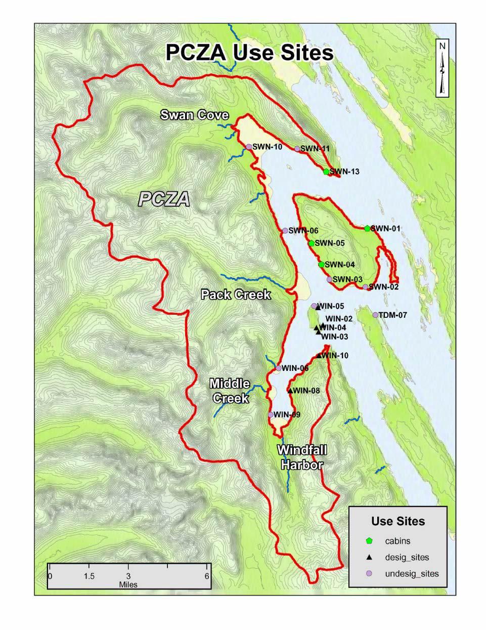
6 CAMPING INFORMATION LOCATIONS There are no established campsites in the area; this is pure Wilderness. However, there are several great areas to camp that are either located where ABAK s kayaks are stored or a short paddle away. Most groups will be dropped off at Windfall Island, depending on bookings and client requests you may also be dropped off at Staunch Point. Windfall Island There are two areas to camp on Windfall. The first is a beach on the northeast tip, the second is the small cove just west of Late Point on the southwest tip near the stored kayaks. From your float plane drop off on Windfall you should walk the beach to the south and go into the woods in a few spots and pick out a nice place to camp. At the Late Point site there is an established bear hang for safely securing your food that is available for your use. Windfall Island does not have any water available. Late Point is about 1.5 miles from Pack Creek. Staunch Point - This site offers excellent camping with a mountain stream running on the edge of the camp and plenty of flat surfaces to accommodate 5 or more tents. The actual camping area is about 1/3 of a mile southwest of Staunch Point as it s shown on the map. It is also another location that ABAK stores kayaks. There is an established bear hang and a mountain stream on the edge of camp. Staunch Point, located at the mouth of Windfall Harbor is a 1/2 mile from Late Point and 2 miles from Pack Creek. Swan Island The west shoreline of Swan Island offers some excellent camping in close proximity to Pack Creek. There are several beaches where you can camp at the forests edge above the high tide line or find flat areas just inside the guard timber. Clear water can be found in a few small streams on the island. Bears will frequent this island, particularly in May-mid June. From Windfall Island camping on Swan is a 1-4 mile paddle away. Paddling to Pack Creek from the west side of Swan Island will range from 1-4 miles. Windfall Harbor It is possible to camp on the East side of Windfall Harbor, but not recommended, as there are a lot of bears in Windfall Harbor. Camping Further from Pack Creek Throughout Seymour Canal you can find beautiful camping areas with flat surfaces for tents and flowing water nearby. When camping on the beach be aware of the large tidal fluctuations and when in the forest don t camp along animal trails. Camping Notes: Tents should be placed inside the trees for maximum protection from rain and wind, and for the softest ground. A few tents spots can be found on the upper beach zone, but be sure to check your tide book! All cooking and eating MUST be done on the beach zone, preferably below the high tide mark so future tides will erase all food scraps and odors. Wood fires are allowed but ONLY on the beach zone, below mean high tide. Do not place any fire rings in the woods or at any time build a fire in the woods (even during rain, the duff under - 5 -
7 ground can smolder and catch fires after you leave this has happened on Windfall!). Firewood is scarce, so collect your wood from a wide area, and do not cut live branches. Leave No Trace camping principles apply (please read the LNT section) A few things to think about: this means all food scraps and veggie material must come out with your garbage; dishes should be scraped and washed in the salt water. Do not cook excess food either eat it all or bag the leftovers and return to town with your garbage rather than dumping big globs of food in the intertidal zone. Do not leave rock rings around your tent, and kick back branches and cones so as not to harden these camping areas. It s a pristine area; let s keep it wild! The toilet is on the beach, below high tide, always! Pee on the beach anywhere. Poop behind a big rock, and then smash it with a nice flat rock and cover it with beach gravel and voila!- the next tide will flush all remains out to sea and microorganisms will quickly dispatch the rest. Fly out wet TP and feminine items with your garbage, or burn in a hot beach fire. Dry TP can be burned on the spot, but only below high tide on the beach. And speaking of feminine products; don t worry about bears and time of month issues. Any concerns along those lines are a myth. WATER Water can be found in one of several streams that cascade off of the mountains on Admiralty Island. It is recommended that all water be treated by either boiling, using a pump/filter, or adding iodine tablets/chlorine based drops (AquaMira). Drinking water is not available anywhere in the area, even at the Pack Creek viewing site. While there is a lot of water to be found along the coastline, there are no streams on Windfall Island. The island is too small to support any freshwater creeks. Instead you should fly in with 3-5 gallons of fresh water (ABAK has water containers available), and can re-supply with new freshwater from the creek with a small waterfall on the main beach of Admiralty Island directly facing the kayak cache, about a half mile paddle across the water. This is most easily done on your way back from a day at Pack Creek. At Pack Creek there is a small stream that you can collect some water from at the beginning of the Observation Tower trail. FOOD You can bring any type of food you wish, from backpacker s fare to gourmet fresh local produce and meats or fish. However, keep a few suggestions in mind: Food should be in zipper duffels lined with garbage bags or waterproof bags, and hung from a tree branch. So --no coolers, no multiple six-packs of beer, and nothing needing freezing or refrigeration (other than our usually cool weather). Plan on bringing a stove and cooking on a stove. In our wet climate you cannot rely on building fires to cook on. You must carry out all garbage and leftover containers. The food you bring to Pack Creek, Windfall Harbor, or Swan Cove for the day must be easily consumed on the spot, without any preparation or warming; snack bars, fruit, sandwiches you prepare back in camp; leftovers in a plastic tub, etc
8 For cocktail hour I recommend a small flask of your favorite booze, or for wine lovers, the small 3-glass servings of boxed wines which are now becoming available and are compact and indestructible. Beer is an inefficient beverage to haul up a tree. If you bring beer cans are recommended as they crush down. Do not bring any alcoholic drinks to Pack Creek! Keep your food hanging or in bear cans whenever you leave camp for more than an hour or so, and during the night. Don t keep any snacks or sweet drinks (including booze) in your tent. It s fine to leave your clean cook gear on the upper beach and personal bags outside your tent. For a fee ABAK will also buy and pack your food, based on a few simple menu options that can be sent to you. LEAVE NO TRACE PRINCIPLES The greater Pack Creek area is entirely within the boundaries of the Kootznoowoo Wilderness and receives minimal impact from humans, particularly anywhere on the land. One of the great things about the area is that it looks the same as it did 100 years ago. As a paddler you are able to experience the feeling of being the first to explore this wild land. In order to preserve this Wilderness character it is important that you follow the seven Leave No Trace principles. Below are the seven principles as well as some guidelines for the Kootznoowoo Wilderness area. 1. Plan Ahead and Prepare: make sure that you have all of the appropriate route knowledge, clothing, gear, safety equipment and food so that you do not have to disturb the natural environment (i.e. cut pieces of trees to make a shelter because you forgot a tent) 2. Travel and Camp on Durable Surfaces: choose tent sites that will not destroy fragile plant life, avoid using the same footpaths to prevent social trails from forming 3. Dispose of Waste Properly: Pack out all trash this includes biodegradable things such as apple cores or orange peels. If it didn t come from the environment you are in, then it shouldn t be left there. Human waste should be dealt with in the intertidal zone in areas where the current will flush the waste out to sea, if you choose to use toilet paper then pack it out or thoroughly burn it in a proper LNT fire! 4. Leave What You Find: Leave treasures for others to find, unless the treasure is trash left by previous travelers 5. Minimize Campfire Impacts: Use a stove to cook on. If possible avoid making fires altogether, if you choose to make a fire then build a small fire in the intertidal zone (BELOW the high tide line, NOT in the forest), only burn wood up to the diameter of your wrist and make sure that everything is burnt completely, no one wants to see large charred pieces of wood floating around on or on the beach where they camp. Please, please, please do not make fire rings in the forest that scar the land for decades or cause forest fires. Even if it s raining the forest duff can smolder/burn for days and spread across large areas of land. 6. Respect Wildlife: Follow the Alaska National Marine Fisheries Service wildlife viewing guidelines and regulations by not approaching marine mammals closer than 100 yards and limiting time to observing one individual to 30 minutes. Keep your food in bear resistant containers or properly hang it to prevent the bears from getting into your food and becoming habituated to - 7 -
9 people. Keep a clean kitchen free of micro food trash, we DON T want to feed ANY wildlife even squirrels, birds, voles, and mice. 7. Be Considerate of Others: If there are other travelers in the inlets, keep your visual and auditory impact to a minimum. Follow the other LNT principles so that future travelers can appreciate the Wilderness to the fullest extent. TIDES Tidal currents are not a significant factor in planning your trip or paddling in Seymour Canal or to Pack Creek, but the tides themselves are very large, and you need to always be aware of whether the tide is coming in or out, and whether the next high tide is higher or lower than the previous. Many people have had problems with underestimating the high tides, and have lost kitchen equipment or even their kayak to an unexpectedly large high tide. Check the tide tables provided with the kayaks, and be sure you understand that there are two high tides and two low tides every day, often with a feet difference, and always with one set of tides several feet higher/lower than the other set in the day. Don t rely on the seaweed line to indicate the height of the next tide! Better to mark high tides during the day with a little rock pile or a stick, and then consult the tide tables to see if the next high tide will be several feet higher or lower. And remember that on shallow beaches, an incoming tide can float a beached kayak within a few minutes, so if you stop and go poke around in the woods during an incoming tide, be sure to bring your kayak much further up the beach than you might think necessary, and always tie the bow line to a rock. You really don t want your kayak to float away.. You can print out tides for your trip by going to Note that any high tide above about a 16 ft. tide can be considered a very high tide, and any minus tides can be considered quite low. For example, you want to keep gear high on the beach or in the woods if there is a very high tide at night, and always carry your kayak into the rye grass zone and tie the bow line to a bush or big rock. Also, ideally you will want to avoid landing at Pack Creek or leaving Windfall Island at a minus low tide, or you will be making a long slog through the low tide muck with a heavy kayak and gear. WEATHER The weather on Admiralty Island is about the same as it is in Juneau. Plan to have cool temperatures with rain showers and hope for sunshine. This area of Southeast Alaska receives measurable precipitation around 220 days a year with 300 cloudy days a year. However, the rain typically falls as relatively light, intermittent showers. The average summer temperature is 56 0 F (13 0 C) with day time highs in the low 60 s and overnight lows in the low 50 s. Although it is possible to have temperatures in the 70 s and low 80 s. The winds in Seymour Canal are generally light, unless the wind is coming directly from the south. Often times Windfall Harbor and the west side of Windfall Island will be calm while the east side of Windfall Island in Seymour Canal is rough and windy. Weather can change quickly, so be prepared for it. Only paddle in conditions you can handle
10 SUGGESTED ITINERARIES Depending on your time and interests there are an endless number of ways that you can do a trip in the Pack Creek area. Given that the majority of the cost of a Pack Creek trip is the float plane flight, we strongly suggest that you spend 3 or more days camping, kayaking, and exploring. Our favorite recommendation is for a 3 day/2 night camping trip, as follows: Day 1- Get your gear and orientation from ABAK around 8 am, and fly in to Windfall Island around 9/9:30. Set up camp, have a snack, pack a lunch and paddle into Windfall Harbor. Spend the day exploring the coastline searching for bears around one of the three salmon streams in the harbor. No permit is necessary and on most days there are no other visitors around. Day 2- After breakfast pack your lunch and extra snacks, then paddle over to Pack Creek to arrive as close to 9am as possible. Spend some time at the viewing spit, eat some lunch, take a hike to the Observation Tower, then stop by the viewing spit afterward. You can stay until it closes at 9 pm. If you stick around you will likely have the last couple of hours for just you, the rangers, and the bears! Bring plenty of snacks, and plan on a late and easy dinner back at camp. (It will still be light until after 10 pm most of the summer, until mid-august.) It s also possible to paddle back to camp for a mid-day break and return to Pack Creek. Note you must have a permit for the day(s) you visit Pack Creek. Day 3- Depending on your flight schedule you can do one of several things: visit Pack Creek again (permit required), paddle Swan Point, explore the Swan or Tiedeman Island Coastline, or simply enjoy a quiet day in camp. Prior to leaving camp for a paddle you should pack up camp to be prepared for your return flight. When you paddle back to Windfall Island (or Staunch Point), stash the kayak back where you found them, clean it out nicely, and await your plane pick-up anytime from about 1-6 pm will likely work. Please be ready for your pickup at least 30 minutes before the scheduled pickup time. This gives you 3 full days of exploration, and 2 nights. Or stay another night to enjoy the wilderness solitude and camping, and fly out after breakfast on Day 4 (there is no extra charge; camping is free!). An added bonus to spending an extra night: there may be discounts available for empty flights returning from dropping off clients in the morning. With more time, you could also paddle to the back of Swan Cove, or actually move camp and explore more of Seymour Canal. In a week you could easily paddle south to Mole Harbor, hike some of the Cross-Admiralty Canoe Route, and paddle back. Or paddle two days to the State Park cabin at Oliver Inlet, spend a night in luxury (well, it s dry and heated), and paddle back to Windfall. A week is not at all too long to explore the myriad islands and coastline of the Seymour Canal area of Pack Creek
11 KAYAKING INFORMATION REQUIRED EXPERIENCE You should be comfortable camping in a cool and wet environment, and have had some experience setting up tents, cooking and living outdoors, etc. This is not an experience for novice campers. Kayaking experience is also required. The waters around Pack Creek are somewhat protected and usually quite calm, but winds do come up and you need to know how to handle a kayak in waves of up to one foot. You must also know how to paddle forward, stop, turn, and load and unload a sea kayak. If you need kayak lessons are unable to take a lesson before coming to Alaska, we can arrange a 2-3 hour private lesson in Juneau before you go. KAYAK STORAGE LOCATIONS The kayaks are stored in two locations, both about a 20 minute flight by floatplane from Juneau. One site is near the southwest end of Windfall Island, the other is southwest of Staunch Point on Admiralty Island (see attached map). For Windfall Island the floatplane pilot will land on the beach near the kayaks, which are located on the ground just 30 feet in from the beach, about 20 yards to the north of the huge boulder on the beach. For Staunch Point the floatplane will drop you off to the left of a stream. The camping is just up the beach. The kayaks are stored on the opposite side of the stream about 75 feet down the beach and 20 feet up into the woods. Kayaks can be kept in these locations during your rental, or you can paddle them to one of the other available campsites. Return kayaks to the same location when you are done, and be SURE to turn them upside down as you found them. Also empty out all water from the cockpits and storage areas, and sponge out dirt and gravel and mud. Please leave them as you would like to find them! All other gear comes back to town in your plane. KAYAK DESCRIPTIONS and ADJUSTMENTS There are a mix of single and double rotomolded plastic touring kayaks available for renters use at both Windfall Island and Staunch Point. The singles (2 at Windfall Island and 1 at Staunch Point) are Current Design Storms or a Wilderness Systems Tsunami. The doubles are either Necky Amaruks or Necky Looksha T s. The doubles are heavy boats. They can be carried by two people, but if possible it s best to carry them with 3 or 4 people. All of the kayaks are sit-in kayaks that require a spray skirt (provided). It is possible to pack up the kayaks with gear for multiple days, however, they are tight on space and you will need to pack lightly and compactly. There may be rental periods where a single is unavailable for an odd number of people. In this instance, it is possible to paddle a double solo, but you will need help getting it to the water. The kayaks all have rudders that are controlled with foot pegs (in the rear cockpit for the doubles). The pegs are adjusted by either pulling a strap (like tightening a backpack strap) or by pushing and sliding the system beside your leg. It is important that the rudder is centered when your feet are pressed evenly on
12 the pegs. To operate the rudder push left to go left, push right to go right. As you push the foot forward to turn the other foot must slide back. KAYAK SAFETY All renters are responsible for their own safety while kayaking. Please look at the attached kayak safety page at the beginning of the Maps section for more information and tips. PADDLING ROUTES AND INFORMATION PADDLING TO PACK CREEK FROM WINDFALL ISLAND It is about 1.5 miles from Late Pt. to Pack Creek, which normally takes about minutes. You can paddle along Windfall Island for the first mile, and then it is only a half mile crossing from the north end of Windfall over to the South Spit at Pack Creek, where you land. These are very protected waters. Only during high winds and storms would you need to hug the shore or delay your paddle. If you paddle past Pack Creek to the north, be sure not to cross over the large intertidal area in front of Pack Creek even when the tide has covered it. This is completely closed to human use, to give the bears a wide buffer. This tide flat extends about one half mile out from the Pack Creek estuary, and is often marked by a line of crab pot buoys. Paddle wide around this tide flat even at high tide if you are exploring the waters to the north of Pack Creek. Remember that the South Spit is the ONLY access point for all visitors to Pack Creek, whether by kayak, floatplane, or vessel. AT PACK CREEK Consult the maps to see where to land your kayak at Pack Creek, at the South Spit. There are two outhaul ropes for public use, and kayakers should use those to the left of the South Spit landing zone. Each is marked with an orange buoy in the water and two wooden posts on land; they consist of a large loop of rope that goes from land to a submerged pulley under the orange buoy, and allow you to store your kayak offshore while at Pack Creek. Note that if you are visiting Pack Creek before June 1 st the outhauls may not be set up. In this case you will have to carry your kayaks up the beach and securely stow all accessories so bears cannot get to them either in a hatch or in the underground bear proof storage bins that are at the forest edge above the South Spit. A paddle float or life jacket makes a great chew toy for a bear. After beaching the kayaks, take your day packs up a few feet to dry ground, and then stash the two-piece paddle and your life vest and spray skirt in the kayak (best to put the spray skirt on the cockpit and cinch it up). Tie the bow line to the outhaul rope with a couple of simple half hitches or a clove hitch: don t put any loop or knot in the outhaul rope itself! Then float the kayak, and then walk up the beach with your day pack while holding on to the other side of the outhaul line: this will pull your kayak offshore. Pull the kayak out until it almost reaches the orange buoy. Once the kayaks are beyond where the lowest tide will reach go check in with the Ranger on duty. They will ask for your permit and give you an orientation to the area. These folks are super helpful; ask them
13 all the questions you want. Also ask them for advice on when you should to go the Observation Tower. The answer will depend on time of day, the tides, your available time and what other groups are planning to go there. And also ask them to point out the two active eagle nests visible from the beach! After having a snack put ALL your food and drinks except water bottle into the underground storage bins at the South Spit. The Ranger will direct you to their location. You can also leave extra clothing, rain gear (if sunny) and rubber boots or other back-up gear that you want available but not in your day pack. The food you bring to Pack Creek should be neatly packaged and ready to eat WITHOUT cutting or laying out on the ground, etc. No picnics! No crumbs! You will be shown where to eat on the beach. The bears will sometimes walk up to lunching visitors and it s important that they can secure their food and stand their ground. Toilets at Pack Creek there are none! You will use the bathroom as is described in the camping information section. There is a pile of rocks on the South Spit that provides some privacy for peeing. If you must poop, then you ll have to walk down the shoreline past the outhauls and go in the intertidal zone. You will need to bring your own TP with some plastic ziplocks to pack it out. You are not allowed to go into the woods to poop or pee near the South Spit or Viewing Spit (that s where the bears go). Don t be shy; that s just how it s done in bear country! (On the trail to the Tower of course you might have to pee, and if so just carry out your toilet paper, but try to avoid having to poop along that hike if possible.) In general we recommend going first to the viewing estuary and spending 1-3 hours there, then going to the Tower (with a stop at the South Spit for a snack or lunch), and then going back to the Viewing estuary. However, the Ranger might advise you to go first to the Tower if it is empty or high tide. Most people come to Pack Creek between 9 am (when it opens each day) and 5 pm, and usually stay 3-5 hours. They usually come by floatplane; a few arrive by private vessel. If you bring a lot of snacks and stay until it closes at 9 pm, and go back to camp for a late dinner, you will likely be rewarded by few or no other visitors, and great evening bear viewing. Note that you will not be allowed to walk to or from the Viewing estuary at very high tides, above about 15 ft. That is a good time to go to the Tower, or just to come earlier or later in the day. The Forest Service has compiled a good list of FAQ s for Pack Creek visitors: They also have on-line a comprehensive Zoological Assessment, with a series of really interesting maps that begin on page 66, showing bear trails and food resources and vegetation types at Pack Creek, Windfall, and Swan: DAY TRIP TO WINDFALL HARBOR A full day of kayaking and hiking the beaches of Windfall Harbor is highly recommended. It is within the Zoological Area, but no permit is required, and few people visit every summer. Bears there are
14 somewhat habituated to people (especially those that include Pack Creek in their home range), but are usually more shy, and tend to fade into the forest when you approach. Thus, paddling close to shore and being quiet is often the best way to see bears in Windfall. The Forest Service requests that paddlers going to the head of the Bay only go ashore at the 3-sided Shelter on the western shore. You can leave your kayak high up on the beach, put food and extra gear (including spray skirts, paddles and life vests, which bears like to chew on) inside the bear-proof storage bins inside the Shelter, and then walk the beach the half mile to the estuary. Don t go out into the estuary and over to the creek, or you will scare bears away just find a place to sit overlooking it all and use your binoculars. You can also poke into the woods around the Shelter (which is not allowed at Pack Creek except on the Tower trail), and look for bear trails, scat, etc. The forest edge between Windfall and Pack Creek is a heavily used bear corridor; don t wander too far into the brush or forest without making some noise. You can also stop at the south end of Middle Creek (see map) and walk up to Middle Creek to look for bears, or again, to check out the bear trails just inside the forest. It is pretty magical. You can either return to Windfall Island the same way you came in, along the western shore, or paddle back along the eastern shore until Staunch Pt., and then do the easy ½ mile crossing back to Windfall. This entire stretch is a good place to go ashore and walk into the forest. There are fewer bears here, and you can look for sign of deer, otter, mink, eagles, song birds and, after mid-july, lush edible blueberry and huckleberry. Notes on bear viewing in Windfall Harbor The bears in Windfall are generally less habituated than the Pack Creek bears, they will be stressed and displaced more easily. The area from Middle Creek to the next creek north should not be walked on. For viewing bears at Middle Creek, land the kayaks on the south end of the tideflat and walk north towards Middle Creek from there. The Windfall Creek area has a lot of high grass and dips along the shore. View with caution in this area as it is easy to surprise bears Do not leave any food or scented items in the kayaks on the beaches. Either carry it with you or put it in the bear box that is available at the Windfall shelter. This area is currently rarely managed by the USFS/ADF&G, use your own judgment and follow the management philosophies that are used for Pack Creek (first concern protection of the bears, second concern following the rules of the Wilderness Act) SWAN POINT and SWAN COVE Swan Cove is the third major watershed within the Zoological Area, and is very difficult to access except at very high tides due to the huge mud flats. It is also too far from Windfall Island for most paddlers to visit in a day trip from Windfall or Staunch Point. Thus it is very rarely visited at all, and then usually by those on longer trips who move camp closer. But you can do a day trip to Swan Point; the spit of land 2.5 miles north of Pack Creek, which has a great gravel beach and an incredible, giant Sitka Spruce with multiple sub-trees growing off it. This makes a
15 nice destination for a day trip. Spend a couple of hours at this little peninsula, see the bear trails and berry bushes and giant tree, and head back. On the paddle to and from the Swan Point area be sure not to paddle over the tide flats in front of Pack Creek, which are off limits to all and serve as a buffer from interfering with bears feeding at Pack Creek. In calm sea conditions you can paddle back along the western shore of Swan Island and take a break to explore some of the muskeg (Southeast Alaska bog) just inside the forest guard timber. TIEDEMAN AND SWAN ISLAND Tiedeman Island is to the east of Windfall Island and Staunch Point. It is a long skinny island that rarely has bears on it. On the north end is a common harbor seal haulout. The north end of Tiedeman Island and the south end of Swan Island are excellent areas that you can safely explore in the forest or go beach combing. There are some interesting small islands with beautiful gravel beaches just to the northeast of Tiedeman that are worth spending time on. Additionally, at certain times of the year humpback whales will frequent the area around Tiedeman Island. BEAR SAFETY Bears swim out to all the small islands during May and early June, when the sedges are coming up and snow covers the higher slopes. While it is rare to see bears on Windfall Island during July and August, you should still practice your good bear country camping techniques (hanging food, no food in tents, cooking and eating on the beach, etc. as outlined below). You may cook any type of food; don t worry about odors, but do worry about leaving scraps on the ground we don t want bears to ever start associating campsites in the area with food opportunities. When camping on Swan Island or at Staunch Point on Admiralty the likelihood of having a bear walk through camp is higher than on Windfall Island. FOOD STORAGE When bear camping all food must be either stored in a bear proof canister (available from ABAK) or properly hung from trees. When hanging food from trees the food bags should be off the ground at least 12 feet and at least 5-8 feet away from the tree trunk. If you are camping in an area without an established bear hang then you will need to look for a sturdy tree branch that is at least 12 off of the ground. Tie a rock or water bottle to the end of the rope and toss the rope over the branch. Tie your food bags to the other end of the rope and hoist it as high as you can. Then wrap the rope around the tree trunk several times and tie it off. In addition to hanging your food it is also a good idea to hang other smellables such as toothpaste, pots, and dishes. Lastly, never cook near your tent or keep food or other smellables inside your tent! BEAR CAMPING PROCEDURES Bears outnumber permanent human residence on Admiralty 3 to 1; it is important to follow bear camping guidelines. For the layout of your camp you want to think of a triangle with each point 100 yards apart
16 One point will be your tent, another point will be your kitchen and the last point will be where you go to the bathroom. Please adhere to the following procedures to prevent our bears from associating people/campers with food and toys. Follow the food storage guidelines above. Cooking should be done away from camp in the intertidal zone so that all the associated smells will be washed away by the ocean. When walking into the woods it is a good idea to make some noise to alert any bears of your presence. This is especially important if you are camped on Admiralty Island or camping in May or June. Keep your camp clean. Everything should either be in your tent, in a bear can or bear hang, or readily accessible. Bears can be like large puppies anything new is a fun chew toy. PROTECTION: BEAR SPRAY, NOISE MAKERS, GUNS ABAK will provide you with a can of bear spray. Note bear spray must be handed to your floatplane pilot before any flight. It will be stored in the float of the plane (not in the main cabin) in case of any accidental discharge. Bear Spray has a range of approximately 30 feet and is very effective if sprayed downwind on a bear that approaches within about feet. However, Pack Creek bears can approach harmlessly within that distance, either on the viewing spit, or along the trail to the tower. There is almost no foreseeable occasion to use bear spray at Pack Creek, and even in Windfall Harbor it would be highly unusual. If on a rare occasion a bear approached a campsite, you might consider using bear spray, but even then it is better to group together between your camp and the bear and just stand your ground and not let the bear move you off of your camp or kitchen area. If you stand together and make a little noise, they will likely go around you and eventually give up and walk away. Noise makers, such as a whistle or air horn, can be excellent bear deterrents. They are unnecessary at Pack Creek, but would be a good thing to have with you when camping on mainland Admiralty or visiting Windfall Harbor and Swan Cove. Do not walk with bear bells, if you are concerned about bears when hiking then talk out loud. This is a sound that bears would associate with people and make them move away from you. Bells may not alarm them. Guns are allowed anywhere in the area; probably anywhere in Alaska! But I do not recommend guns, especially at Pack Creek where there has never been human contact by a bear. The Forest Service ranger on duty at Pack Creek by the estuary will have a gun, but again, a gun has never been used. PROCEDURES FOR A BEAR ENCOUNTER When traveling anywhere on Admiralty Island you should bring along bear spray and noise makers, such as whistles and signal horns. If you encounter a bear the first thing you want to do is group together tightly. Then, let the bear know you are there by talking to it in a loud, low voice. If it approaches you, stand your ground, particularly if you have food with you or are in the Pack Creek/Windfall Harbor area. Continue to talk to it loudly and make it clear that it needs to travel around you. If you do not have food and are not in the Pack Creek viewing area, then it is acceptable to back away slowly while continuing to
17 talk to the bear. When in the Pack Creek viewing area the bears are habituated to people, so it is unnecessary to talk loudly to make your presence known. A good acronym for responding to bear encounters is SPRAY. S Stand Your Ground P Pull Out Your Bear Spray R Roundup Your Group A Act Human (stand tall, talk to the bear) Y Yield To The Bear EQUIPMENT INFORMATION EQUIPMENT PROVIDED WITH RENTAL With a kayak rental the following equipment is included: Kayak and Accessories - kayak, 2-piece kayak paddle, life jacket, spray skirt, paddle float, bilge pump, sponge, rubber boots Safety Equipment - marine radio, bear spray, small first aid kit Information Pack Creek information packet and maps RECOMMENDED EQUIPMENT LIST It is important to be prepared for the cool, wet climate of Southeast Alaska. Bring enough equipment to be warm, dry, and comfortable. However, be aware that there are space and weight limitations in the floatplanes and kayaks. Below is a basic recommended equipment list. Clothing Camping Other T-Shirt Sleeping Pad Insect Repellant Hiking Pants Sleeping Bag Sunscreen Long Underwear Top and Bottom x 2 Tent Binoculars Fleece/Insulating Jacket x 2 Cookset and Knife Camera Rubber Rain Jacket Camp Stove Toiletries (minimal) Light Weight Rain Jacket Fuel/Fuel Bottles Medications Fleece or Wool Hat Lighters/Matches Watch Fleece or Wool Gloves Water Bottle Sunglasses Sun or Baseball Hat Water Bags/Containers Bandana Socks and Underwear Water Treatment Day Pack Rubber Boots Headlamp First Aid Kit Camp Shoes (tennis shoes/hiking boots) Tarp Hand Sanitizer EQUIPMENT AVAILABLE FOR RENT Above and Beyond Alaska has a limited supply of equipment available for rent. Contact our office to inquire about availability and make a reservation. The rates listed below are 2014 rates that do not include a 5% local sales tax. All rental gear requires a credit card on file even if paying with cash
18 Miscellaneous Equipment Kayak Equip. Clothing Cooking Tents Sleeping Bags EQUIPMENT RENTAL ITEMS Daily Rate (1-3 days) Weekly Rate (4-7 Days) Synthetic Sleeping Bags w/ optional liners $10 $40 Sleeping Pad $5 $20 Tent-2 person $10 $40 Tent-3 person $15 $60 Tent-6 person $20 $80 Cooking Tent (River Wing) $10 $40 Bathroom Tent $8 $32 Packs Day Hiking Packs $5 $20 2 Burner Stove (excluding fuel) $10 $40 1 Burner Stove (excluding fuel) $8 $32 Cookware set (pots, pans) $5 $20 Utensils, plate, bowl, mug (per person) $2 $8 Portable Cooking Table $5 $20 Water Purifier $3 $12 Water Bottles $1 $4 Drysuit $15 $60 Waterproof heavy duty rain jacket/pants $8 $32 Windproof jacket/pants $5 $20 Fleece Gloves $2 $8 Paddle Mitts $2 $8 Dry Bags - small $2 $8 Dry Bags - large $3 $12 Portable Toilet $10 $40 Ice Cooler $5 $20 Headlamp $4 $16 Rain Tarp $3 $12 Webbing $2 $8 Bear Canister $5 $20 Flares $3 $12 Fishing Net $3 $12 OTHER INFORMATION EMERGENCIES There is no cell phone service at or near Pack Creek. I will provide you with a marine handheld radio as part of the rental package. This can be used to check the marine weather forecast (press WX button), and to call for assistance on Channel 16 (and then switching to channel 10 usually, after contact is made). These work line of sight for a few miles, and can be used to reach a passing boat or the Ranger Camp if you are at Pack Creek or nearby (probably will not work across land from your campsite on the south end of the island). The Rangers maintain a camp with three wall tents on the north end of Windfall Island, within view of the South Spit at Pack Creek. They have radio contact with their Sitka Dispatch office, and can arrange for 911 emergency service out of Sitka (either floatplane or helicopter with medical personnel). For lesser
19 emergencies, the Rangers can help somewhat. They have some first aid training and equipment, but are NOT medics. If you need Ranger help during the evening or night, you should paddle to their camp rather than attempt to hike the one mile overland across Windfall Island. There is no trail, and the understory is thick and horrible to bushwhack through. If you need to change the time of your floatplane pick-up, or have other non-medical issues, it would be best to ask another visitor or pilot who is there for the day to relay that message for you, rather than asking the rangers to use the government radio system. But depending on the situation, and your level of pleading, you might obtain their help. PLANE CAPACITY There are several Juneau-based air taxi carriers that may be used depending on your group size and schedule. In general, these are the planes and weight limits (including passenger weights!): Float Plane # of Passengers Weight Capacity Cessna 180/206 2/3 + gear 750 lbs / 340 kg Dehavilland Beaver 4 + gear (up to 6 with minimal gear) 1200 lbs / 545 kg Dehavilland Otter gear (up to 10) 2400 lbs / 1090 kg It should be relatively easy for people weighing pounds to keep their gear and food within these total limits for any 3-5 day trip, even considering you will want to bring 3-6 gallons of fresh water in portable bags/jugs. You and your gear will be weighed at the airport before departure. Be aware that in addition to a weight capacity, the planes also have a space capacity. FISHING Fishing is not allowed within the Zoological boundaries, but you may fish from Windfall Island or other islands. Be sure to clean fish away from camp, and leave all remains below high tide. Fishing licenses are needed for anyone over age 16 for all saltwater fishing, and can be obtained for 1, 3 or more days from several outlets in Juneau. QUESTIONS or COMMENTS If you have any other questions, please contact the Above and Beyond Alaska by phone or or info@beyondak.com. Contact our office to let us know of any additional information you would have liked to have had prior to your trip. Also, we would love to hear back from you about how your trip went. Send an , call on the phone, or write a review on Trip Advisor or our Facebook page. Thank you
 Avoid Sudden Movements Keep Your Weight Centered (shoulders over hips) Turn with Your Head to Look Behind You Point Your Bow")


20 Kayak Rental Shop Above & Beyond Alaska PREVENT A CAPSIZE: DO NOT Rush or Try to Paddle As Fast As Possible plan ahead and keep track of time DO NOT Make Adjustments When Away From Shore (i.e. changing seat position or rudder position) Avoid Sudden Movements Keep Your Weight Centered (shoulders over hips) Turn with Your Head to Look Behind You Point Your Bow Into Approaching Waves Respect wildlife and give marine mammals plenty of space (minimum 100 yards) PADDLING SAFETY TIPS and INFORMATION GENERAL SAFETY CONSIDERATIONS Stay Close Together as a Group Stay Close to Shore as Much as Possible Take a Break Before Making an Open Crossing Break Before You Are Tired Paddle Slow and Steady Pay Attention to Boat Traffic motor boats have the right of way Know the Tides and Marine Forecast observe the wind Carry a Communication Device - (marine radio or cell phone) in a waterproof case on your PFD IN CASE OF EMERGENCY: REMAIN CALM Attempt to Manage Situation re-enter kayaks, get to shore, hail another boat, call for help Contact Pack Creek Rangers on Channel 16 using the Marine Radio Assisted Rescue Paddling Technique Self Rescue - 0 -

21 - 1 -

22 - 0 -
23 - 1 -

24 - 2 -

25 - 3 -

26 - 4 -

27 - 5 -
Seymour Canal/Oliver s Inlet/Pack Creek Trip Information
 Seymour Canal/Oliver s Inlet/Pack Creek Trip Information Written and Provided by: Above and Beyond Alaska General Admiralty Island is a large island located to the west and southwest of Juneau. The island
Endicott Arm and Holkham Bay Trip Information
 Endicott Arm and Holkham Bay Trip Information GENERAL Located just 45 miles south Juneau is Holkham Bay, the starting point for two world class paddling destinations: Endicott Arm and Tracy Arm. Endicott
Jewell Island Overnight Sea Kayak Trip Packet
 Jewell Island Overnight Sea Kayak Trip Packet Thank you for considering an island-hopping multi-day adventure with Portland Paddle! Below you'll find a sample trip itinerary that will give you a better
Bears of Katmai - A Photo Expedition with Barbara Eddy
 Bears of Katmai - A Photo Expedition with Barbara Eddy Aug 28 - Sept 3, 2019 7 days/6 nights - Limited to 10 guests PO BOX 575, Ronan, Montana 59864 Phone 208-244-1887 barbaraeddyphotography@gmail.com
SCHUYLKILL RIVER SOJOURN 2018 GENERAL INFORMATION AND POLICIES
 SCHUYLKILL RIVER SOJOURN 2018 GENERAL INFORMATION AND POLICIES The Schuylkill River Sojourn is a 7-day, 112-mile guided canoe and kayak trip with a wealth of learning opportunities and fun on the Schuylkill
TRIP DETAILS // MIDDLE FORK
 TRIP DETAILS // MIDDLE FORK CHECK LIST: Complete the Boundary Expeditions Guest Information Form at boundaryexpeditions.com Make travel arrangements to Stanley, Idaho, to arrive day before your launch
Floating the Buffalo National River. with First River Outfitter. Michelle Hulett. exp2010_w01h3buffalo2_ann_solution
 Floating the Buffalo National River with First River Outfitter Michelle Hulett The Buffalo River Beginning as just a trickle, The Buffalo National River runs down the Boston Mountains, flows north and
Crescent Lake Lodge Hunting Information
 Crescent Lake Lodge Hunting Information If you are a non-resident alien, you must be accompanied by a licensed guide to hunt Brown/Grizzly Bear and Dall Sheep. We fly you from the lodge to your hunting
EQUIPMENT LIST FOR THE CANADIAN BARREN GROUND CARIBOU HUNTS
 EQUIPMENT LIST FOR THE CANADIAN BARREN GROUND CARIBOU HUNTS Backpack we recommend the Eberlestock X2 pack for this hunt - Packed with digital camera, good fixed blade knife, batteries, flashlight, etc
SITKA SHORE EXCURSIONS
 SITKA SHORE EXCURSIONS A traditional Tlingit Native center, the capital of Russian America, and the first capital of the United States Territory of Alaska, Sitka retains the flavor of each of these historic
KAYAK PUMALIN. What better than our human propelled kayaks to discover this amazing region and pay tribute to the conservation project.
 Program : Self Support sea kayaking expedition. Experience required: None Intensity: Very active Location: CHILE Northern Patagonia The best way to discover northern Patagonia Pumalin Park. Pumalin park
2010 COLUMBIA RIVER GORGE and OREGON COAST PHOTOGRAPHY WORKSHOP
 MACRO and More Macro and More Photography Workshops present 2010 COLUMBIA RIVER GORGE and OREGON COAST PHOTOGRAPHY WORKSHOP Mike Moats and Jack Graham June 10-14 2010 COST: $795.00 (travel, meals, etc.
What better than our human propelled kayaks to discover this amazing region and pay tribute to the conservation project.
 Program : Self Support sea kayaking expedition. Experience required: None Intensity: Very active Location: CHILE Northern Patagonia The best way to discover northern Patagonia Pumalin Park. Pumalin park
PADDLING THE LOWER STILLAGUAMISH RIVER by Paddle Heaven
 PADDLING THE LOWER STILLAGUAMISH RIVER by Paddle Heaven PUBLISHED BY: Paddle Heaven on Smashwords Paddling the Lower Stillaguamish River Copyright 2010 by Paddle Heaven All rights reserved. Without limiting
Holliday Air, Inc. Terry C. Holliday P.O. Box Chugiak, Alaska Tel - ( Fax - (907)
") Holliday Air, Inc. Terry C. Holliday P.O. Box 670109 Chugiak, Alaska 99567 Tel - (907 688-4337 Fax - (907) 688-4338 Welcome & General Information Thank you for your interest in Holliday Air and the services
Holliday Air, Inc. Terry C. Holliday P.O. Box 670109 Chugiak, Alaska 99567 Tel - (907 688-4337 Fax - (907) 688-4338 Welcome & General Information Thank you for your interest in Holliday Air and the services
Traveling to Your Broughton Archipelago / Johnstone Strait Mothership KAYAKING Adventure
 Traveling to Your Broughton Archipelago / Johnstone Strait Mothership KAYAKING Adventure Important Points Columbia III will be moored at the CAB Fuel Dock in Port McNeill (250) 956-4044 or 956-3336. www.mothershipadventures.com/maps/port_mcneill_bc_map.htm
DESTINATION FISH TOGRAPHY PHO
 DESTINATION FISH FOR TRAVELING ANGLERS THERE S NO PLACE LIKE Alaska PHOTOGRAPHY: DEBORAH LONGWILL The first question you need to ask yourself is what you want to experience. I ve never been a fan of roughing
KETCHIKAN SHORE EXCURSIONS
 KETCHIKAN SHORE EXCURSIONS Ketchikan is Alaska s Gateway City and is perhaps most famous for its reputation as the Salmon Fishing Capital of the World. It is also home to a large population of Alaska s
NOLS Alumni Trip Sea Kayaking Prince William Sound, Alaska July 23 29, 2017
 NOLS Alumni Trip Sea Kayaking Prince William Sound, Alaska July 23 29, 2017 Features of this Trip 6 Nights 7 Days In The Field Abundant Alaskan Wildlife Paddle Single and Double Kayaks Coastal & Intertidal
Alpine Rock Skills Course Pre Course Information
 Thank you for choosing us as your instructors for your mountain skills training. The following information is intended to help you prepare for your course. We hope that it answers most of your questions.
BEAR RIVER MERCANTILE BOWRON LAKE BC
 BEAR RIVER MERCANTILE BOWRON LAKE BC PO BOX 251, WELLS BC, V0K 2R0 / 604-424-4330 / WWW.BOWRONLAKE.COM WWW.FACEBOOK.COM/BOWRONLAKE / SANDY@BOWRONLAKE.COM 1/14/2014 2014 Sandy Phillips B.R.M. Info Sheet
Senior School Explore Expedition Sea Kayak in Nootka Sound
 11/05/2016 Senior School Explore Expedition Sea Kayak in Nootka Sound Fri. May 13 Wed. May 18, 2016 AGENDA Teacher Introduction Where is Nootka Sound? Itinerary Meal Planning Gear Preparation Learning
The Namdal Coast is magnificent!
 The Namdal Coast is magnificent! Imagine waking up on a beach after sleeping under the open sky on an island far out in the archipelago. High above you soar a pair of majestic sea eagles. The open ocean
HUNT ID: 5074-G-L-1395-ElkMDeer-CO-521-ON2IAPA-TSMA3NHUN-1JB-Cabin or Drop Camp
 HUNT ID: 5074-G-L-1395-ElkMDeer-CO-521-ON2IAPA-TSMA3NHUN-1JB-Cabin or Drop Camp With a higher than average success rate, an outfitter with a top notch set of experienced guides and a better than average
Canoe Route. Dogtooth Lake-Highwind Lake-Dryberry Lake- Lake of the Woods-Blindfold Lake
 1 Canoe Route Dogtooth Lake-Highwind Lake-Dryberry Lake- Lake of the Woods-Blindfold Lake This is an interesting and challenging route starting and ending at Rushing River Provincial Park. It passes over
AlpenView Wilderness Lodge, Inc. P.O. Box 8571 Kodiak, Alaska U.S.A. (907)
") AlpenView Wilderness Lodge, Inc. P.O. Box 8571 Kodiak, Alaska 99615 U.S.A. (907) 654-5373 mail@alpenview.com www.alpenview.com Thank you for choosing AlpenView for your Alaskan experience. We will do our
AlpenView Wilderness Lodge, Inc. P.O. Box 8571 Kodiak, Alaska 99615 U.S.A. (907) 654-5373 mail@alpenview.com www.alpenview.com Thank you for choosing AlpenView for your Alaskan experience. We will do our
PGI GREENLAND THE OUTDOOR COMPANY OF ILULISSAT SUMMER SEASON 2018
 PGI GREENLAND THE OUTDOOR COMPANY OF ILULISSAT SUMMER SEASON 2018 ILULISSAT KAYAKING MORNING From 1st of June to 15th of September Paddle in a kayak and witness the overwhelming beauty of icebergs coming
Nanaimo Ocean Swim and Newcastle SUP Race Safety Plan
 Nanaimo Ocean Swim and Newcastle SUP Race Safety Plan Use of this document Permission is granted to reproduce any information in this document; however, please notify the author (Matthew Lamb) if doing
Snow Goose Hunt Information Package Licensing
 Snow Goose Hunt Information Package Licensing Waterfowl Haven Outfitters (#3045) does not provide, nor is responsible, for licensing of any type. It is extremely important to check licensing guidelines
Welcome & General Information Terry C. Holliday P.O. Box Chugiak, Alaska Tel Fax
 Welcome & General Information Terry C. Holliday P.O. Box 670109 Chugiak, Alaska 99567 Tel 907 688-4337 Fax 907 688-4338 Thank you for your interest in Holliday Air and the services provided by our group.
John Day River SUP Bass Fishing DAY Trip
 Little Creek Outfitters PO Box 343 Maupin Oregon, 97037 Marty s Cell Phone: (503) 819-4035 Mia s Cell Phone: (541) 419-2105 Email: guides@littlecreekoutfitters.net Website: www.littlecreekoutfitters.com
OUTDOOR ROCK CLIMBING ADVENTURES
 Beginner/Intermediate Trip SPLORE OUTDOOR ROCK CLIMBING ADVENTURES Adventure Packet: Everything You ll Need to Know Climbing Outdoor Rock Climbing Adventures ½ to Full Day Adventure for Beginner/Intermediate
Level 3 Skills Course
 Level 3 Skills Course This course develops seamanship and leadership in multi-day touring. The participant in Level-3 will develop practical leadership, risk assessment, decision-making, judgment, group
SUMMARY OF MAJOR CHANGES 2016 EDITION SAFETY ACTIVITY CHECKPOINTS SEPTEMBER 2016
 SUMMARY OF MAJOR CHANGES 2016 EDITION SAFETY ACTIVITY CHECKPOINTS SEPTEMBER 2016 INTRODUCTION The 2016 edition of the Safety Activity Checkpoints publication saw many changes from the 2015 edition. This
British Columbia s Great Bear Rainforest
 British Columbia s Great Bear Rainforest 9-days searching for salmon, bears, whales, and wolves in the largest coastal temperate forest in the world One of National Geographic s 20 places to see in 2014
$7.99. High Efficiency Low Price. Great Quality. Get it now for only:
 High Efficiency Low Price Get it now for only: Great Quality $7.99 Proven to be successful for catching: Walleyes, Northern, Haddock, White Bass, and Salmon Dear Readers, Thank you for buying this new
Guest Checklist Keep Me and Check Me Often!
 Guest Checklist Keep Me and Check Me Often! Please review this material and we will see you reel soon. This material is intended for the sole use of Doc Warner s Alaska Adventures What to Bring Items marked
Neches River Trip ~ 40 miles March 16-18, 2016
 Neches River Trip ~ 40 miles March 16-18, 2016 Isolated and remote canoe camping on large relatively flat sand bars Carrying everything you need No Wal-Mart Canoeing, swimming, eating, praying, fire Americas
I m going to talk about my float trip last year to the Kanektok River in Alaska. The interesting thing about this trip was our approach.
 I m going to talk about my float trip last year to the Kanektok River in Alaska. The interesting thing about this trip was our approach. We wanted to get an experience which is significantly different
ROYAL CANADIAN AIR CADETS PROFICIENCY LEVEL ONE INSTRUCTIONAL GUIDE SECTION 3 EO M OBSERVE SITE POLICIES AND PROCEDURES PREPARATION
 ROYAL CANADIAN AIR CADETS PROFICIENCY LEVEL ONE INSTRUCTIONAL GUIDE SECTION 3 EO M190.03 OBSERVE SITE POLICIES AND PROCEDURES Total Time: 60 min PREPARATION PRE-LESSON INSTRUCTIONS Resources needed for
PLANNING A TRIP TO THE SEASHORE CHECK LIST
 PLANNING A TRIP TO THE SEASHORE CHECK LIST Action: 1. Access / Facilities 2. Risk Assessment 3. First Aid / Emergency 4. Tide Tables / Changing Tides / Weather forecast 5. Volunteers 6. Plan the Day of
Outdoor Recreation Unit. Obj. 8, 9, 10
 Outdoor Recreation Unit Obj. 8, 9, 10 Fishing Equipment and Styles Fishing line Buy good quality line Select a proper test for expected fishing type Proper line for reel Line types Bait casting: braided
Quartz Mountain Nature Park
 Quartz Mountain Nature Park Situated on the tranquil shores of Lake Altus- Lugert at the western end of the Wichita Mountain range, Quartz Mountain Nature Park is one of Oklahoma s premiere state parks.
Vermont State Parks Venture Vermont Outdoor Challenge
 Vermont State Parks 2018 Venture Vermont Outdoor Challenge This is your Venture Vermont scorecard! Keep track of the activities that you complete by checking the box next to the activity. Make sure you
OUTDOOR ED. Huntingtower Year 10 Climb. Student and Parent Information Booklet. 23 rd 27 th Feb 2015
 Student and Parent Information Booklet Huntingtower Year 10 Climb 23 rd 27 th Feb 2015 OUTDOOR ED 1. EDUCATIONAL AIMS: - To develop Outdoor Education Skills - To develop Independence 2. LOCATION: Mt Araplies
In 2015 we paddled from Blue Gums Caravan Park (near Eildon) to Seymour. In 2016 we paddled from Seymour to Shepparton.
 to Seymour. In 2016 we paddled from Seymour to Shepparton.") Goulburn River Shepparton to Moama, 19-24 th November 2017 This was the third leg of the journey down the Goulburn River. In 2015 we paddled from Blue Gums Caravan Park (near Eildon) to Seymour. In 2016
Goulburn River Shepparton to Moama, 19-24 th November 2017 This was the third leg of the journey down the Goulburn River. In 2015 we paddled from Blue Gums Caravan Park (near Eildon) to Seymour. In 2016
Basic Climbing Class (BCC) Student Gear List
 Student Gear List") The Basic Climbing Class (BCC) uses a large amount of mountaineering gear to provide safety and personal comfort. The BCC gear list provides students with the minimum gear requirements for this course.
The Basic Climbing Class (BCC) uses a large amount of mountaineering gear to provide safety and personal comfort. The BCC gear list provides students with the minimum gear requirements for this course.
Fairbanks outdoorsman shares his bear safety expertise
 Close this window Print this page Fairbanks outdoorsman shares his bear safety expertise Glenn BurnSilver Originally published Sunday, September 21, 2008 at 12:00 a.m. Updated Sunday, September 21, 2008
Smoking Onboard Safety Procedures Diving Equipment Diving Experience Dive Accident
 General Rules Smoking Onboard It is not allowed to smoke in the cabins and in the salon. The liveaboard has fire alarms installed for your safety which are activated with a little amount of smoke. Please
Bobbie the Safety Boat Lesson Plan 1 PFDs Canadian Coast Guard Auxiliary
 the Safety Boat Lesson Plan 1 PFDs Canadian Coast Guard Auxiliary Target : small children and adults combined size: small to medium Team Participants operator - resource material s Lifejacket / PFD Kit
Explorer S A F A R I S
 Modus Operandi 1 2 Huge storm! Luckily we got camp set up before it broke... We saw a huge herd of eles early this morning - couple of calves too. Managed to get a bit of ishing in at lunch time - bream
Explorer S A F A R I S
 Modus Operandi 1 2 Huge storm! Luckily we got camp set up before it broke... We saw a huge herd of eles early this morning - couple of calves too. Managed to get a bit of ishing in at lunch time - bream
Welcome to Bert Adams River High Adventure
 Welcome to Bert Adams River High Adventure Dear Troop and Crew Leaders, It is my pleasure to welcome you to the second season of high adventure at Bert Adams Scout Camp. I am excited to return to the River
Lake O Hara Lodge Winter Backcountry Packing List
 Lake O Hara Lodge Winter Backcountry Packing List Winter Backcountry Skiing & Snowshoeing Packing List Ready to Experience the Pure, Unfiltered beauty of a wilderness ski or Snowshoe Adventure, but are
Cape Lookout Field Trip: Coastal Processes and Responses (modified after Riggs, 1997)
") Cape Lookout Field Trip: Coastal Processes and Responses (modified after Riggs, 1997) I. Dates Friday, November 5 through Sunday, November 7. We will camp near the Cape Lookout Lighthouse. We will get
Cape Lookout Field Trip: Coastal Processes and Responses (modified after Riggs, 1997) I. Dates Friday, November 5 through Sunday, November 7. We will camp near the Cape Lookout Lighthouse. We will get
Sandhill Crane Hunt Information Package Licensing
 Sandhill Crane Hunt Information Package Licensing Waterfowl Haven Outfitters (#3045) does not provide, nor is responsible, for licensing of any type. It is extremely important to check licensing guidelines
OCEAN RIVER ADVENTURES YOUTH KAYAKING CAMP (AGES YRS)
") OCEAN RIVER ADVENTURES YOUTH KAYAKING CAMP (AGES 12-14 YRS) (5 days) This is one camp you ll want to be sent off to! Get the experience of a lifetime! Over five days, you ll learn how to paddle a sea kayak,
OCEAN RIVER ADVENTURES YOUTH KAYAKING CAMP (AGES 12-14 YRS) (5 days) This is one camp you ll want to be sent off to! Get the experience of a lifetime! Over five days, you ll learn how to paddle a sea kayak,
in the St. Croix Valley
 in the Parks Your Guide to in the St. Croix Valley Our parks and trails are fun places to PowerUp! Explore the amazing, family-friendly parks and trails, right here in the St. Croix River Valley. Use this
Downeast Lakes Water Trail and Reading Room
 Downeast Lakes Water Trail and Reading Room Last summer my 25 year old daughter Anna and I did a "canoe trip" on the Grand Lakes. We paddled, but not for bragging rights. We were there to absorb quiet,
TRIP DETAILS // MIDDLE FORK
 TRIP DETAILS // MIDDLE FORK CHECK LIST: Complete the Boundary Expeditions Guest Information Form at boundaryexpeditions.com Make travel arrangements to Stanley, Idaho, to arrive day before your launch
The hunting vessel, your base camp, offers some amazing amenities:
 ADAK CARIBOU HUNTS Our vessel-based un-guided Adak caribou hunts are a truly unique adventure; caribou, duck, and ptarmigan hunting, along with fishing. No bears! No biting insects! No thorny brush! Caribou
Glacier Bay Kayaking & Wildlife Adventure. 8 Days
 Glacier Bay Kayaking & Wildlife Adventure 8 Days Glacier Bay Kayaking & Wildlife Adventure Few places are as hauntingly beautiful as Southeast Alaska. Rich in stunningly preserved nature and wildlife,
Water Treks Five Rivers Trek
 Water Treks Five Rivers Trek Camp Daniel Boone is proud to partner with the Nantahala Outdoor Center (NOC) to provide our Scouts with multiple rafting opportunities. NOC has been in operation since 1972
FALL 2016 HUNTING PROGRAM. Before you arrive
 Thank you for choosing the C Lazy U Ranch for your hunting destination! This packet will go over what to expect during the week, as well as anything you might need to bring. If you have any additional
2018 Ikari House - Christmas Island Itinerary
 2018 Ikari House - Christmas Island Itinerary Trip Dates: May 30 th - June 6 th, 2018 6 Full Days of Fishing Cost: $2950 per angler *2:1 Guide to Angler Ratio Standard *1:1 Guide Ratio Available for Additional
Ocean Light II Adventures
 The Great Bear Rainforest The Mid Coast of British Columbia from Rivers Inlet to the Skeena River is also known as the Great Bear Rainforest. This area is true wilderness and sees very few human visitors,
PORT SOLENT SAILING SCHOOL JOINING INSTRUCTIONS
 PORT SOLENT SAILING SCHOOL JOINING INSTRUCTIONS 2 WELCOME TO SUNSAIL ARE YOU READY TO GAIN YOUR SEA LEGS? To help you get ready to start sailing, we have put together this introduction to the Sunsail sailing
gorilla and chimpanzee safari
 Chimps of Tanzania DAY BY DAY ITINERARY gorilla and chimpanzee safari 888.658.7102 info@deeperafrica.com www.deeperafrica.com OVERVIEW: CHIMPS OF TANZANIA In the remote Mahale National Park, 80 miles south
Welcome to School of Nashville Ballet Summer Intensive 2016! We are pleased you will be joining us this summer.
 Welcome to School of Nashville Ballet Summer Intensive 2016! We are pleased you will be joining us this summer. This packet will help you plan your trip to Nashville and make preparations to stay on the
Florida National High Adventure Sea Base February 10-16, Overseas Highway Islamorada, Florida 33036
 DATE: JANUARY 1, 2019 TO: National Camping School Participant Florida National High Adventure Sea Base February 10-16, 2019 73800 Overseas Highway Islamorada, Florida 33036 FROM: MATT HART, DIRECTOR NATIONAL
1. TRAVEL. a. WHERE AM I GOING? Hummingbird Tree-house Rental Information
 1. TRAVEL a. WHERE AM I GOING? Hummingbird Tree-house Rental Information i. To get to the island of Green Turtle, you must fly to the nearest island with an airport since Green Turtle is too small to accommodate
Scorpion Reef paradise.
 Scorpion Reef a forgotten saltwater fly fishing paradise paradise. ise. Alacranes Reef Atoll aka Scorpion Reef Atoll Is the largest offshore coral structure in the Gulf of Mexico and belongs to the State
NORTHERNAIRE HOUSEBOATS WELCOMES YOU TO OUR WILDERNESS HOME!
 NORTHERNAIRE HOUSEBOATS WELCOMES YOU TO OUR WILDERNESS HOME! Rainy Lake is the largest lake in Voyageurs National Park and the nation s most beautiful! This 73-mile long body of clear, fresh water holds
VO V L O U L N U T N E T E E R E HA H N A D N B D O B O O K O
 VOLUNTEER HANDBOOK 2018 Colonial Relay Volunteer Handbook Thank you for volunteering for the 7 th annual Colonial200 and 6 th annual Colonial70 Relays. Without you we would not be able to have a successful
Hunting equipment packing list archery / gun
 Hunting equipment packing list archery / gun We at the All-Canada Show are avid hunters and over the years we ve developed a master packing list. We re providing our list to you as a guide of what you
Float Tube Angling. Capt. Jim Barr Skinny Water Charters Newport, RI
 Float Tube Angling Capt. Jim Barr Skinny Water Charters Newport, RI Float Tube Angling Why Fish from a Float Tube? Equipment Techniques Safety Why Fish from a Float Tube? Fun Relatively inexpensive Extremely
The Scottish Highlands
 Sea Kayaking The Scottish Highlands View Trip Dates Book Now Trip Grade: Green 2 The Scottish Highlands Our expert guides teach essential sea kayaking skills while you journey through some of the best
NFCT-Waterway Work Trip Holeb Falls Portage, Moose River, ME Stone Staircase July 5-9, 2017
 NFCT-Waterway Work Trip Holeb Falls Portage, Moose River, ME Stone Staircase July 5-9, 2017 Introduction: The Moose River Bow Trip is a 3 to 4 day paddle that can be completed in a loop by connecting Attean
OCEANS & WILD RIVERS
 OCEANS & WILD RIVERS Two unique lodges, two distinct pockets of Alaska. Enjoy fishing adventures that will take you from the Inside Passage to the western edge of the Alaska Range, cruising in motorboats
BECOMING A WILDLIFE DETECTIVE
 BECOMING A WILDLIFE DETECTIVE INTRODUCTION Many people come to the Gunflint Trail to see wildlife. Although we often think of wildlife as large animals like moose and bears, on the Gunflint Trail we re
WINDSURF SHOP SHELL KEY CAMP GROUND FT DESOTO EGMONT KEY
 Managed to engineer a quick intrastate trailer trip. I was looking on craigslist for a cheap, used windsurfing rig and ran across a posting for this paddle board I had looked into before, which was ironically
Polar Bear Interaction Plan
 Polar Bear Interaction Plan Introduction This plan is meant to help guide researchers and CPS staff in dealing with polar bears should they encounter them while working or living in the Arctic. It is important
WILDERNESS HUNTING INFORMATION PACKET 2017
 WILDERNESS HUNTING INFORMATION PACKET 2017 2017 WILDERNESS HUNTING PRICE INFORMATION EARLY RIFLE SEASON BIG GAME ELK (priority), DEER, BLACK BEAR, WOLF $5000 package deal Tent camp ARCHERY WILDERNESS BIG
Confirmation Package: Surf Camp Check List
 PO Box 414, San Clemente, CA 92674 949-498-7862 www.endlesssummersurfcamp.com Confirmation Package: Important Information: The following confirmation package contains very important information regarding
Fraser Island nd 30 th September 2017
 Fraser Island 2017 The Great Sandy Strait 22 nd 30 th September 2017 An eight day expedition along the southern side of Fraser Island. Alternate trip due to NNW wind forecasts negating the original Hervey
FLOAT/WADE FLY FISHING TRIPS $475 per day (includes lunch) Boats accommodate 2 persons plus guide
 Boats accommodate 2 persons plus guide") FLOAT/WADE FLY FISHING TRIPS $475 per day (includes lunch) Boats accommodate 2 persons plus guide Fishing Licenses not included in price of excursions/trips. For license information check out Montana Fish
FLOAT/WADE FLY FISHING TRIPS $475 per day (includes lunch) Boats accommodate 2 persons plus guide Fishing Licenses not included in price of excursions/trips. For license information check out Montana Fish
adventure beckons. Your next fly fishing
 Your next fly fishing adventure beckons. Minutes feel like months as you count down to your journey. You imagine landing jumbo rainbows in the boulder-churned pocket water of Henry s Fork. Pursuing three-figure
BASIC GEAR GUIDE: WHAT YOU NEED TO FLY-FISH by Carol Cambridge. Cambridge
 BASIC GEAR GUIDE: WHAT YOU NEED TO FLY-FISH by Carol Cambridge Cambridge The type of fly fishing you choose TODAY, and how serious you become in the FUTURE, relates to the gear you need. Most people start
DESHUTES RIVER 3-Day Trip Itinerary TRIP AT A GLANCE DAY 1: DAY 2: DAY 3:
 We are thrilled you have chosen to raft the Deschutes with River Drifters! Please plan ahead and bring a sense of adventure and discovery to ensure a wonderful trip. TRIP AT A GLANCE Difficulty: Class
2018 Timberline Fall Camporee
 2018 Timberline Fall Camporee September 28 September 30,2018 Lead Valley Range Scoutmaster/SPL Planning Guide Revised 6/9/18 June 15, 2018 The 2018 Shooting Sports Camporee Committee invites you to take
WHITEWATER RAFTING AND KAYAKING
 WHITEWATER RAFTING AND KAYAKING WHAT TO BRING Dry change of clothing for return trip Towel Shoes that can get wet and are comfortable to hike in (Sandals with heelstrap or light weigh, lace up shoes) Clothes
Ocean Light II Adventures
 Orca Explorer The northern tip of Vancouver Island is an incredibly rich and abundant wildlife area. During the summer months it is home to a wide variety of marine mammals as the Pacific Ocean delivers
A TRIP TO CAMP CISAME 2 days & 1 night or 3 days & 2 nights (UPSTREAM FROM REGINA)
") A TRIP TO CAMP CISAME 2 days & 1 night or 3 days & 2 nights (UPSTREAM FROM REGINA) TRIP SCHEDULE STANDARD STAY PACKAGE (2 days or 3 days) DAY 1 9.00am Gathering at our Régina landing stage to board a pirogue
A TRIP TO CAMP CISAME 2 days & 1 night or 3 days & 2 nights (UPSTREAM FROM REGINA) TRIP SCHEDULE STANDARD STAY PACKAGE (2 days or 3 days) DAY 1 9.00am Gathering at our Régina landing stage to board a pirogue
1.3 INTRODUCTION 1.4 OBJECTS OF ASSOCIATION 1.5 DEFINITIONS
 PREAMBLE 1.3 INTRODUCTION Sea Kayak Club WA Inc. provides and coordinates a variety of recreational sea kayaking activities for its members with emphasis on safety and minimization of the hazards and risks
Bears, Bears and Bears Oh My! July 21-28, 2019 Lake Clark National Park, Alaska
 Bears, Bears and Bears Oh My! July 21-28, 2019 Lake Clark National Park, Alaska For the past eight summers I ve had some of the most amazing experiences of my life! I was photographing wild brown bears
Dangers of the Yellowstone National Park
 Dangers of the Yellowstone National Park Dangers of the Yellowstone National Park 1 If we forget the fact that there is a potential danger of the explosion of this super volcano, there are several realistic
The spring and the fall hunts either hunt is $15,500 which includes lodging and meals with the guided hunt.
 Hunt ID: AK-BBear-All-King Salmon-ABH-Bud Meet face to face with a giant coastal Brown bear just across the inlet from Kodiak Island. These bears average 9 foot squared, and every year this outfitter puts
WILDERNESS HUNTING INFORMATION PACKET 2019
 WILDERNESS HUNTING INFORMATION PACKET 2019 2019 WILDERNESS HUNTING PRICE INFORMATION EARLY RIFLE SEASON BIG GAME - ELK (priority), DEER, BLACK BEAR, WOLF $5000 package deal Tent camp ARCHERY WILDERNESS
Go to pcesar.org/join and subscribe to the Membership and Training Information Mailing List
 About Pierce County Explorer Search & Rescue: In 1956 Explorer Search and Rescue (ESAR) was formed in King County starting with one explorer post. Search and rescue (SAR) was in its infancy in the United
2009 WILDERNESS HUNTING PRICE INFORMATION
 2009 WILDERNESS HUNTING PRICE INFORMATION EARLY RIFLE SEASON BIG GAME ELK (priority), DEER, BLACK BEAR $4500 package deal GENERAL SEASON BIG GAME ELK (priority), DEER, BLACK BEAR $4500 package deal LATE