K2 and Capitol Peak. Climbers: Rick Crandall, Rick Peckham, Andy Mishmash and Susan Meunchen Sept. 6,
|
|
|
- Hilda Eaton
- 6 years ago
- Views:
Transcription

1 K2 and Capitol Peak Difficulty: Class 4 Exposure: Capitol Summit Elev.: 14,130 feet K2 Summit Elev.: 13,688 feet Trailhead Elev.: 8,450 feet Elevation Gain: 5,800 feet to Capitol RT Length: miles Trailhead: Snowmass Creek Climbers: Rick Crandall, Rick Peckham, Andy Mishmash and Susan Meunchen Sept. 6, Capitol Peak, most climbers would agree, is the scariest and most challenging of the 58 fourteeners in Colorado. It is a soaring granite peak with airy ridges, steep rock faces, and a sharp summit that, along with its nearby 13er companion peak, K2, offer stunning views across the Maroon Bells-Snowmass Wilderness Area. Capitol Peak not only looks like a big mountain, but it climbs like one too. Capitol and K2 are part of the Elk Mountain range near Aspen. They are among the important peaks that I see from my house windows every day. Here are a few photos in various lighting conditions taken from my deck. Perhaps you can see why I ve been committed to climbing them. Capitol 14,130 K2 13,688 Mt. Daly 13,300


2 Capitol Peak was named by the 1874 Hayden Survey for its resemblance to the United States Capitol Building in Washington DC. Although the Hayden Survey named Capitol Peak, they made no attempt to climb it. As one member of the survey team, Henry Gannett, put it: the peak's "prism-shaped top and precipitous sides forbid access." The first recorded ascent of Capitol Peak was by pioneer climbers Percy Hagerman from Colorado Springs and Aspen and Harold Clark, an Aspen lawyer, on August 22, 1909.

3 K2 is the smaller peak just before the infamous "knife edge" ridge on the way to Capitol Peak. It is named "K2" for its resemblance in shape to the world's second highest peak in Pakistan. Despite the scary exposure of the knife edge ridge, the actual casualties that occasionally do occur, they are more often due to falls near the loose summit of K2 and by lightning strikes. The standard trailhead access to the climbing route is a 6.5 mile backpack up 2200 to Capitol Lake. We chose a lesser-known approach which is a 5.5 mile backpack up 2800 to treeline (and no nearby water) for a more private experience using the Snowmass Creek trailhead. Snowmass (also known locally as Old Snowmass, which is different than Snowmass Village the ski resort) is an unincorporated town and a U.S. Post Office located in Pitkin County. It is situated in the valley of the Roaring Fork River, near the mouth of Snowmass Creek between Aspen and Basalt. It consists largely of a post office, several commercial businesses and surrounding houses and ranches. Estimated current population is 1365 happy souls. Given the challenge-factor of Capitol Peak I happily waited until friend and expert mountain climber, Andy Mishmash freed up from his construction contracting work to lead us. His friend and experienced Class 5 climber Susan Meunchen and my friend of many of these climbing stories, Rick Peckham, rounded out our party. Clearly I was the junior member (from a climbing skills standpoint ) but all were patient with my determined yet slower speed. Rick P. and I had just completed a hard, successful climb up Mt. Eolus and N. Eolus, two Class 3 fourteeners in the San Juan Range. We had only two days of rest before the Capitol opportunity with Andy popped up, but we went for it. At just after noon on a Saturday we loaded up our backpacks and started the somewhat uncharted backcountry trek from the Snowmass Creek trailhead. We followed Andy s nose rather than any trail map that usually is my guide. 1 ½ miles into the trek we needed to cross the frigid creek which numbed our feet almost immediately. There are trails many of them mostly caused by animals. In the lower reaches we crossed private ranches and their cows, requiring us to dance around the many cow pods. In higher reaches there were occasional signs of Elk and bear.


4 Susan adding constant cheer to our trek up towards the West side of Mt. Daly. We headed generally towards Moon Lake, a high alpine lake at about 11,000 but chose to hike higher up on the Mt. Daly shoulder for a more direct approach to the endless boulder field we would face in the morning. At just about tree-line we found one of the few nearly level areas to set up our three tents. Rick P. immediately started scouting rocks to make a fire ring while Andy and Susan dragged enough dead trees for our fire to last us much longer than our one night campout. Rick P. trimming his fire ring with rocks.
 vegetables of all kinds, many bags of sugary gummies, chocolates, etc.")

5 It was then that we got to see the wonders contained in Andy s huge backpack. It would literally have qualified as a mini Whole Foods store. There seemed to be no limit to the weight Andy would carry, which we learned even more about the next day. He had large bags of hydrated (i.e. heavy) vegetables of all kinds, many bags of sugary gummies, chocolates, etc. for energy the next day, dessert cookies, four corns and the six 8 oz hamburgers and buns I d purchased for a great cookout. Andy cooking our hamburgers and the corns were roasting along the front sides of Rick s fire ring. We ate and warmed at the fire as night approached, although we had no need for headlamps as the full moon gave us a huge amount of light. Note on Rick P. s left the two bladders of wine which is our tradition this time we had Walter Hansel Pinot Noir and Kobalt Cabernet Sauvignon. We were in our tents at about 9 pm to get some sleep before a very early rise at 3:00 am.


6 At 3:30 am we were on the trail in total darkness as the moon had set over Mt. Daly. Since we were well above Moon Lake and low on water, we welcomed coming across a small creek where Andy and Rick P. set about filtering water into our collapsible 2 gallon jug. They filled 3/4ths of it which I calculate at 13 lbs. and guess where it went? Yup, inside Andy s pack! We hiked uphill in the dark for three hours under the cliffs of the West face of Mt. Daly (the big mountain you see) and into the huge and miles-long boulder field. The blue line is approximately the standard route from Capitol Lake on the other side of the Capitol-Daly saddle. While we had a totally private campout, I m thinking I might have had an easier day coming from the shorter Capitol Lake approach. We got to the point of intersection at about daylight at 6:35 am. Rick P. (left) and Rick C. (right) scrambling up the easier of the boulders. They got a lot worse further up. Somewhere in this huge mess of boulders, Andy found an almost perfect heart-shaped rock of size. He wanted it although not badly enough to carry to summit. So he placed it on top of another rock, like he was really going to find it on the way down. Tune in later in the story.


7 It was light but not yet sun on us, so we still had layers on as the boulder field got increasingly steeper. However, while long, these rocks were more stable than we d experienced in recent climbs. Eventually the sun warmed us and the boulder field got steeper yet. Still our target was not yet in sight. As far as we could see at this point, perhaps 7 am, the weather was looking good, and we needed it because this was going to be a long day.


8 Andy had warned me for the last two years that this would be the longest and most tiring boulder field in my experience and I needed to get especially fit for it. In fact many say the crux of the Capitol climb is getting to the K2 summit at the top of this boulder field. Somewhere about here I was starting to see what he was talking about. K2 Finally around 8 am we had K2 in our sight although still a long boulderfield away but at least it gave us a target to aim at instead of just endless rocks.


9 These brown rocks were actually easier to climb up on since they were pretty solid and had some flat surfaces you could aim for. Further up where they get gray in color they change to very sharp rocks angled every which way and take much more care to avoid a fall. As we got closer to the final approach to the K2 summit, we were high enough to look afield at weather conditions. This is because once at the K2 summit, the knife edge to Capitol is right on the other side and committing to that in impending poor weather is not a good idea. The K2 summit is upper right. We were approaching from the far side you can t see. The knife edge is this side of the summit as you see. The exposure on the K2 summit and the knife edge is what everyone is talking about. Here s one description: It s a short, exposed section on the ridge that requires concentration and solid nerves. If you are spooked by exposure, this area may twist you in knots. Scramble along the crest or walk along the left side while holding onto the ridge. Experienced climbers can carefully walk across most of the Knife Edge. The last portion of the knife becomes quite sharp." The K2 summit is is a good place to take a serious look at the weather and make a go or no-go decision.


10 The summit isn t far away, but the remaining climb is time-consuming and not a place to be in bad weather. Well if you ve read other of these stories you know we ve been pretty lucky with weather but still have had to give up on some summit attempts, returning to them on a better day. On this day, approaching the K2 Summit we looked in the distance and this is what we saw. This was not good, although the weather was still far in the distance. So we decided that Rick P. and Susan, both experienced climbers and much faster than me would move on ahead to go over the K2 summit and go for the Capitol summit. I would go at my slower pace to summit K2 and at least eyeball the rest of the approach to Capitol for a later attempt much as we did earlier in the year with Mt. Eolus which we did successfully summit only days ago. Rick C. going for the K2 summit. There are Class 4 moves here which are rated this high due to the extreme exposure, steepness and loose rock. There were, however, mostly good hand and footholds.


11 Rick C. at summit of K2 13,688 at 9:30 am, 5 ¾ hours from campsite. Capitol Peak is about 480 higher and center-rear of the photo. Andy stayed with me (he took the photo) but we lamented later we didn t get a photo together. this time. The views from K2 are tremendous. This is the horrendous, winding ridge from Capitol Peak to Snowmass Mountain shown on the far left, another 14er we d just summited a month ago, see


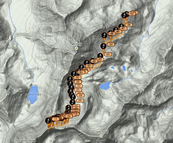
12 Looking down at Pierre Lakes and off in the distance are the Maroon Bells and Pyramid Peak, the latter being my most exciting climb, done with Andy earlier, see: The SPOT message I sent from the summit of K2. The red is our path from camp on the side of Mt. Daly. The blue is the standard route from Capitol Lake. The yellow is the remaining climb to Capitol Peak taken by Rick P. and Susan.


13 So, while at the summit of K2 I turned around and there was the knife edge and remaining climb to Capitol Peak so near yet so far. At my speed it was likely a 5 hour round trip from K2 to Capitol and back. It took Rick P. and Susan a fast 3 hours which they went for hoping the weather would hold off that long. Rick P. and Susan on the knife edge

 he actually tightropes")
14 Here s a closeup of that same photo. Rick P. in blue helmet is using one of the moves which is feet on the right side of the edge and hands on the knife while Susan is straddling. When Andy does it (which he has over a half dozen times) he actually tightropes it! Susan on the knife-edge. The drop-off on both sides is 1500.
 and Susan past the knife")

15 Above: Rick P. (upper climber) and Susan past the knife edge and heading up the final summit pitch to Capitol. Below: Reaching the summit. (note the skies are no longer blue).
 reduce the approach time to K2 which I think I can do from Capitol Lake, and 2) pick a pair of")

16 Summit Capitol Peak, 14,130 approximately 1 ½ hrs from K2 summit. Congratulations to Rick and Susan for bagging Capitol. As for me, having seen the remaining route, mostly what I need to get to the Capitol summit is to 1) reduce the approach time to K2 which I think I can do from Capitol Lake, and 2) pick a pair of days where good weather is guaranteed and not just 30% chance of thunderstorms. In the meantime, appropos of the weather, today s story isn t quite done. As Rick P. and Susan headed off the summit of Capitol, and at the same time as Andy and I had descended from the K2 summit but were still in the large, gray, tricky boulderfield heading down, the weather descended on us both. Of all things it was a snowstorm! Actually what was coming down is called graupel something between snowflakes and hail but wetting and slippery nonetheless.

17 Both pairs of us proceeded very carefully and fortunatly the precipitation didn t last longer than maybe 20 minutes and soon after the sun returned. Also even more fortunately it didn t get electrical yet. After another 20 minutes the sun had dried the rocks and we all proceeded at a normal pace. Rick C. back down into the good rocks with flatter surfaces.


18 OK, so remember the heartrock that Andy found on the way up, miles down from our summits? Well somehow he found it again! And this time it went into his pack another 15 lbs. in addition to the water, food and who knows what else was lurking in there.

 when as though something magical from above obliterated the storm it was over and the skies cleared.")
19 By about 2:30 pm we were finally 5 hours down from most of the rocks but still ½ hour from camp and it happened. A huge gathering cloud mass moving fast and gathering static electricity started throwing lightning bolts and exploding with thunder. To a climber, an electrical storm is much scarier than exposed rock climbing and we were in it. I was about to throw away my hiking poles (made of metal) when as though something magical from above obliterated the storm it was over and the skies cleared. The next thing that happened took our breath away the brightest double rainbow, complete from end to end (one of the ends pointing to our campsite on the left) appeared as if to say I gotcha covered, enjoy the rest of your day!

20 We hiked to camp, packed up and backpacked 2800 and 5.5 miles down to the stream

21 This was a 16 ½ hour day after an equally long climb in the San Juans several days earlier I was tired. But it was a super two days I wouldn t have missed, despite my not getting Capitol Peak. I now have a strategy for how to get it in future and I ve since heard from Andy and from Rick that if one doesn t get me up it the other one will. That will be a day I ll never forget but this was close.
22
K2 and Capitol Peak ( The King )
") Difficulty: Class 4 Exposure: K2 and Capitol Peak ( The King ) Trailhead: Start: Summit: Total Gain: RT Length: Capitol Creek 9,450 feet 14,130 feet 5,300 feet 17.00 miles Climbers: Rick Crandall, Andy
Difficulty: Class 4 Exposure: K2 and Capitol Peak ( The King ) Trailhead: Start: Summit: Total Gain: RT Length: Capitol Creek 9,450 feet 14,130 feet 5,300 feet 17.00 miles Climbers: Rick Crandall, Andy
Wetterhorn Peak: A Class 3 Fourteener Adventure with Andy Mishmash
 Wetterhorn Peak: A Class 3 Fourteener Adventure with Andy Mishmash Difficulty: Class 3 Exposure: Summit Elev.: Trailhead Elev.: Elevation Gain: RT Length: 14,015 feet 10,800 feet 3,300 feet 7.00 miles
Little Bear Peak Bad Boy of the Colorado Fourteeners West Ridge and Southwest Face - New Route Ascent, Standard Route Descent
 Little Bear Peak Bad Boy of the Colorado Fourteeners West Ridge and Southwest Face - New Route Ascent, Standard Route Descent Difficulty: Class 4 Summit Elevation: 14,037 feet Campsite Elevation: 10,000
Date Time Location Weather Fish Species Size Range Fish Caught Flies Used Techniques Comments
 IRON BOG LAKE & CRATERS OF THE MOON Date Mid August 2011 Time Location Iron Bog Lake, Fishpole Lake, Craters of the Moon National Monument & Hayspur Fish Hatchery Pond. Weather Clear Fish Species Rainbow
High Uinta Wilderness
 High Uinta Wilderness July 5-7, 2010 Elevation: 10,000 11,000 Grayling, Brook, Cutthroat It was that time of year again to do my annual backpacking/fly fishing trip with my brothers. This year my brothers
North Maroon Peak Difficulty: Exposure: Summit Elev.: Trailhead Elev.: Elevation Gain: RT Length: Climbers
 North Maroon Peak Difficulty: Class 4 Exposure: Summit Elev.: 14,014 feet Trailhead Elev.: 9,590 feet at Maroon Lake Elevation Gain: 4,500 feet RT Length: 10.00 miles Climbers: Rick Crandall; Andy Mishmash,
Day 1 (Farley 7745, Bow Knot, Toxaway 8323)
") Date August 8 12, 2005 Time Location Sawtooths (Tin Cup Trailhead) Weather Scattered Clouds Fish Species Rainbow, Brook, Cutthroat Size Range Brook 6-11 Rainbow/Cutthroat 12-18 Fish Caught To many to count
Date August 8 12, 2005 Time Location Sawtooths (Tin Cup Trailhead) Weather Scattered Clouds Fish Species Rainbow, Brook, Cutthroat Size Range Brook 6-11 Rainbow/Cutthroat 12-18 Fish Caught To many to count
HURL ELKHORN 50K RUN AID STATIONS COURSE MARKINGS
 HURL ELKHORN 50K RUN AID STATIONS The race starts and finishes at Crystal Creek Campground, where primitive camping is available. The race starts at 7:00 am. The finish cut off time is 9:00 pm. No drop
Lakes up Lake Creek drainage in the White Knob Mountains: Golden (Golden), Big (Cut, RB), Rough (Cut, RB), Long (RB), Round (Grayling).
, Big (Cut, RB), Rough (Cut, RB), Long (RB), Round (Grayling).") Date Early September Time All Day Location Copper Basin Area; Sun Valley, ID Weather Clear Fish Species Golden, Cutthroat, RB, Grayling Size Range 10 16 Fish Caught Several Golden & Cutthroat Flies Used
Date Early September Time All Day Location Copper Basin Area; Sun Valley, ID Weather Clear Fish Species Golden, Cutthroat, RB, Grayling Size Range 10 16 Fish Caught Several Golden & Cutthroat Flies Used
Desert Trek. Alex Tamayo. High Noon Books Novato, California
 Desert Trek Alex Tamayo High Noon Books Novato, California Contents 1 Friends.... 1 2 The Trip.... 6 3 The First Problem....10 4 Red Camper...14 5 Snake Canyon...19 6 Rattlesnake...22 7 Ride for Help....28
Navigating Briones: getting around an advanced orienteering course. Brown Course, October 2011.
 Navigating Briones: getting around an advanced orienteering course. Brown Course, October 2011. The trek to the start this year wasn t short and boy was it steep. But this should be treated as an opportunity
Absaroka-Beartooth Wilderness Date August 11-17, 2013 Time Location The Beaten Path Absaroka- Beartooth Wilderness, MT
 Absaroka-Beartooth Wilderness Date August 11-17, 2013 Time Location The Beaten Path Absaroka- Beartooth Wilderness, MT Weather Cloudy for the most part Fish Species Brook & Cutthroat Trout Size Range Small/medium;
SHIP S PROW. Access. Approach #1 from Peaks of Grassi. Approach #2 via Three Sisters Creek. Ship s Prow - 309
 SHIP S PROW Ship s Prow is the very prominent, sharp buttress between The Three Sisters and Ha Ling Peak. It has a large, steep face on its northwest side and is about 450 m high. To date, only two routes
By Joel Bender
 By Joel Bender thought I was pretty lucky in 2008, drawing an Alaska 14C I Dall sheep tag. It was a lucky draw and an incredible hunt capped off with a beautiful ram and an adventure with my guide and
Plan C Southwest Ridge of Cloudy Peak Peter Laurenson
 Plan C Southwest Ridge of Cloudy Peak Peter Laurenson Despite the record breaking sunshine hours in the first part of 2016, our third nominated weekend to make an attempt on Sefton from Welcome Pass again
Approach. Via Stewart Creek Three Sisters
 three sisters The Three Sisters are a signature landmark for the Bow Valley and the town of Canmore. They may even compete with Mount Rundle above Banff as the most photographed and painted mountain scene
Darrington Rock Climbing Sampler. Page 1. a mini-guide to some routes in Clear and Copper Creeks
 a mini-guide to some routes in Clear and Copper Creeks Joe near the top of Exfoliation Dome. Near Darrington, Washington, there are several granite domes in scenic mountain valleys. This is not sport climbing:
3/8/2016 Oregon Wallowa Mountains Published by Michael Hatch (Wallowa Avalanche Center) and Scott Savage (on behalf of USFS National Avalanche Center)
 and Scott Savage (on behalf of USFS National Avalanche Center)") Location: Place Chief Joseph Peak, Wallowa Mountains State Oregon Date 3/8/2016 Time 1630 hrs Summary 1 skier partially buried and killed Number: Caught 1 Fully Buried 0 Injured 0 Killed 1 Avalanche Details:
Location: Place Chief Joseph Peak, Wallowa Mountains State Oregon Date 3/8/2016 Time 1630 hrs Summary 1 skier partially buried and killed Number: Caught 1 Fully Buried 0 Injured 0 Killed 1 Avalanche Details:
Stuart Range Traverse attempt September 10-11, 2011 by Mike Rolfs.
 Stuart Range Traverse attempt September 10-11, 2011 by Mike Rolfs. Aaron and I hike fast, but what we learned on this trip is that comfort without a rope on steep terrain is the key factor to reasonable
JC Mesa Ranch. Colorado - San Miguel County - Telluride
 Commanding stunning views of Telluride and surrounding peaks, the 2,379 deeded-acre JC Mesa Ranch is one of the only remaining undeveloped and unencumbered ranches in the Telluride area. Surrounded by
Boulder Mountain Fly Fishing: Rick s Fishing Blog:
 THE BOULDERS Date Mid September Time All Day Location Boulder Mountain in southern Utah Weather Clear Fish Species Tiger Trout, Splake, Brook Trout & Colorado Cutthroat Size Range 14-22 and larger Brook
Blackmare Lake Date Late August 2012 Time Location Blackmare Lake McCall, ID Weather Clear Fish Species Brook Trout
 Blackmare Lake Date Late August 2012 Time Location Blackmare Lake McCall, ID Weather Clear Fish Species Brook Trout Size Range Small Fish Caught Many Brook Trout Flies Used Elk Hair Caddis, Royal Wulff
Bridger Wilderness Wind River Range Pinedale, WY Aug , miles / 25+ lakes Elevation: 8,000 11,000
 Bridger Wilderness Wind River Range Pinedale, WY Aug. 10-14, 2009 50 miles / 25+ lakes Elevation: 8,000 11,000 This is the trip that I have been anticipating for years. I consider the Wind Rivers to be
Wyoming, Grand Teton National Park (2 ) Fred Ford (2 5 ), John Austin (26) and Robert Bartholomew (20) spent the night of June 27 in high camp in the
 Fred Ford (2 5 ), John Austin (26) and Robert Bartholomew (20) spent the night of June 27 in high camp in the") Wyoming, Grand Teton National Park (2 ) Fred Ford (2 5 ), John Austin (26) and Robert Bartholomew (20) spent the night of June 27 in high camp in the lower saddle between the Grand and M iddle Teton. In
Wyoming, Grand Teton National Park (2 ) Fred Ford (2 5 ), John Austin (26) and Robert Bartholomew (20) spent the night of June 27 in high camp in the lower saddle between the Grand and M iddle Teton. In
Union Creek Avalanche Accident
 Union Creek Avalanche Accident February 19, 2012 Date: 2/19/2012 Location: Union Creek Basin. Back country east of Crystal Mountain Resort. Summary: Three skiers triggered and caught by ~20-inch deep X
Timing: 2 days Grade: AD- / Moderate snow slopes some steep climbing - Beginner suitable
 PERUVIAN ANDES ADVENTURES CLIMB VALLUNARAJU 5686m (18655 ft) Timing: 2 days Grade: AD- / Moderate snow slopes some steep climbing - Beginner suitable Eli & Rolando Morales & the Peruvian Andes Dog (Cholo)
A Guide to Unicorn Canyon Peter Nelson, Craig Doram Zak McGurk cruising the second ascent of Money Jane
 A Guide to Unicorn Canyon Peter Nelson, Craig Doram Zak McGurk cruising the second ascent of Money Jane P a g e 2 Table of Contents Introduction... 2 Getting There... 2 Climbing Area Descriptions... 5
Marble: 9:10 am Creede: 11:57 am Today s Airtime: 2.8 hrs Total PIC Time: Total Logged Time:
 Sunday, September 10, 2017 Cobra flight #599, PIC #612, 1 landings Lilly Lake, Redstone Castle, Schoefield Pass, Maroon Bells, Maroon Lake, Half Moon Pass Marble: 9:10 am Creede: 11:57 am Today s Airtime:
The Kilimanjaro Porters & Guides. My Motivational Inspiration- Karen Jolly
 The Kilimanjaro Porters & Guides My Motivational Inspiration- Karen Jolly In June 2011, I was given the opportunity to climb Mt. Kilimanjaro, Africa s highest mountain and the highest free standing mountain
Chapter Contents 1. Variety / 2. Other things to think about. Back to Other Chapters. 1. Variety
 --------- multipitchclimbing.com --------- This site presents the images from the ebook High: Advanced Multipitch Climbing, by David Coley and Andy Kirkpatrick. In order to keep the cost of the book to
Calaveras Big Trees State Park--South Grove Loop
 Copyright 1999 by Jeff Robinson. You are free to use and reproduce this description for personal, not-for-profit, and not-forbusiness use. Any reproduction other than for personal use, including businesses,
Gospel Hump Wilderness Date Late August 2012 Time Location Twin, Moores, Slate & Gospel Lakes Grangeville, ID
 Gospel Hump Wilderness Date Late August 2012 Time Location Twin, Moores, Slate & Gospel Lakes Grangeville, ID Weather Clear Fish Species Brook, Rainbow & Cutthroat Trout Size Range Small; a few 14-16 Rainbow
Rock Climbing in Kowloon, Qing Yuan County, Guangdong, PRC
 Rock Climbing in Kowloon, Qing Yuan County, Guangdong, PRC The following notes, maps and topos form a rough guide to most of the established climbing in the Kowloon (Nine Dragons) area of Qing Yuan County,
End Time Location Fees. F 9/28 5:00 PM 9:00 PM McAlexander Classroom Sat,Sun 9/29-9/30 8:00 AM 5:00 PM McAlexander Climbing Center
 REGISTRATION CLASSES Class Day(s) Date(s) Start Time CLIMB Wall Instructor Certification Course (Current skills check and 3-5 hours reading and prep work due before first class) End Time Location Fees
Weather Rain/snow first two evenings and then clear and sunny Fish Species Golden Trout, Grayling, Brook, Cutthroat, Rainbow, Cutbow hybrid
 Date August 20-24, 2007 Time All day every day Location White Cloud Peaks near Stanley Idaho (central Idaho) Weather Rain/snow first two evenings and then clear and sunny Fish Species Golden Trout, Grayling,
! Mt. Elbrus Expedition Russia
 ! Mt. Elbrus Expedition Russia July 23 - August 5, 2016; July 22 - August 4, 2017 $4,950 (land costs) Difficulty Level: Introductory No technical climbing or altitude experience is necessary. Elbrus does
Gasherbrum II and Hidden Peak-New Routes
 Gasherbrum II and Hidden Peak-New Routes WOJCIECH KURTYKA, Klub Wysokogbrski, Krakciw, Poland RIGINALLY THE ALEX MACIN- TYRE Memorial Expedition was to have had three members. The tragic death of Alex
Henry s Avalanche Talk
 Henry s Avalanche Talk How to stay safe so you can have more fun off piste Safety is Freedom Preface This article is provided to HAT club members who have registered for free on our website. It is intended
6 day trek from Cathedral Peak to Champagne Castle, Central Drakensberg, South Africa
 6 day trek from Cathedral Peak to Champagne Castle, Central Drakensberg, South Africa Vultures retreat near Champagne Castle, looking north to Cathedral Peak and the Devil s tooth This 6-day trek crosses
REAL ESTATE MARKET REPORT
 Third Quarter 2017 ASPEN SNOWMASS REAL ESTATE MARKET REPORT presented by KLUG PROPERTIES CHRIS KLUG 970.948.7055 Klug Properties THIRD QUARTER 2017 MARKET REPORT Happy fall season from Aspen! I hope you
Wildhorse Classics. Pat McGrane November 20, 2014
 Wildhorse Classics Pat McGrane November 20, 2014 This document describes some of the classic technical rock climbs in the eastern Pioneer Range of Idaho. It includes routes in Wildhorse Basin as well as
T,R 1/15-1/24 7:00 PM 10:00 PM Dixon Climbing Center $114 $342 $399
 2019 REGISTRATION CLASSES Class Day(s) Date(s) Start Time End Time Location Fees CLIMB Efficient Climbers Tool Box M,W 1/28-2/6 7:00 PM 10:00 PM McAlexander Efficient Climbers Tool Box T,R 1/29-2/7 7:00
In the 1850s, mail delivery was not as fast as it is today. Airplanes had not yet been invented, and neither had cars. Railroads had been invented,
 The Pony Express In the 1850s, mail delivery was not as fast as it is today. Airplanes had not yet been invented, and neither had cars. Railroads had been invented, but the railroad tracks did not run
They have cabins and camping with a large camp kitchen equipped with stoves, fridge, microwave and BBQ. Why go anywhere else?
 ABOUT Mt Trio is situated in the Stirling Ranges which is typically known for multi pitch adventures. This crag offers quality bolted climbing with most routes being steep and long, whilst being in a stunning
First Grade Spelling Lists
 First Grade Spelling Lists List 1 List 2 List 3 List 4 me can ten my do see tan up and run tin last go the ton not at in bed us on so top am a no he good it now you is man will she we an List 5 List 6
Las Conchas Climbing Guide for Cattle Call Wall and Gateway Rock. Jemez Mountains, New Mexico
 Las Conchas Climbing Guide for Cattle Call Wall and Gateway Rock Jemez Mountains, New Mexico Jason Halladay halladay@gmail.com Last updated 30 August 2007 Cattle Call Wall With its thirty-second approach
To Benefit the Wachusett Mountain Race Team!
 To Benefit the Wachusett Mountain Race Team! Handbook Outline: Race Overview & Events Schedule....3 Leg 1: 5-mile Run... 4 Leg 2: Scenic Bike Race.....5 Leg 3: Summit Climb......6 Leg 4: Ski Run...7 Application.....8
Lesson 7: The Pony Express
 Lesson 7: The Pony Express In the 1850s, mail delivery was not as fast as it is today. Airplanes had not yet been invented, and neither had cars. Railroads had been invented, but the railroad tracks did
Eardley Canyon, Straight Wash San Rafael Swell, Central Swell
 Eardley Canyon, Straight Wash San Rafael Swell, Central Swell Rating: Best Season: Time: Access: Permit: Equipment: Map: Cold Protection: Drinking Water: Flash Flood Risk: Skills Required: Technical Note:
TEST EXAM PART 3 ADVANCE LAND NAVIGATION
 NAME DATE TEST EXAM PART 3 ADVANCE LAND NAVIGATION 1. Knowing these four basic skills, it is impossible to be totally lost; what are they? a. Track Present Location / Determine Distance / Sense of Direction
The Weekend Warrior. VeloSano Training Guide
 VeloSano Training Guide The Weekend Warrior By Dr. Michael Schaefer This guide includes suggestions for training for the VeloSano Bike to cure event of your chosen distance. If you are new to bicycling,
Welcome to the 3 day Leadville Stage Race!
 Welcome to the 3 day Leadville Stage Race! This Year marks the 23rd anniversary of the first Leadville Trail 100 mountain bike race. We are excited to have you join us for the second year of this challenge.
Black Hills, South Dakota, June 2017
 Black Hills, South Dakota, June 2017 Greetings! We just returned from a five day rock climbing trip in the Black Hills of South Dakotahere's our trip report. Day 0 We decided to split the 14 hour drive
Course Planning COF Conference
 Course Planning 2011 COF Conference Today s presentation What is a good course? Course planner s raw ingredients Cooking up good courses: Long / Middle What s different about Sprint? JWOC 2011 courses
1 The village party. Read and listen.
 Read and listen. 1 The village party Sophia Walter and her brother, William, lived in a small village. On the last day of May, Sophia said to William, It s June next month and 21st June is the longest
PRISTINE. PRIVATE. PERFECT.
 PRISTINE. PRIVATE. PERFECT. A sublime parcel of the American West, Inyanga Ranch consists of over 530 acres of beautiful river frontage, ponds, meadows and historic cabins at the end of a box canyon, protected
THERE MUST BE A WAY Jim Low a play for primary school students
 THERE MUST BE A WAY Jim Low a play for primary school students Lyrics and/or music if required for the play available on: http://acrossthebluemountains.com.au/ Characters: Gregory Blaxland, William Lawson,
multipitchclimbing.com
 --------- multipitchclimbing.com --------- This site presents the images from the ebook High: Advanced Multipitch Climbing, by David Coley and Andy Kirkpatrick. In order to keep the cost of the book to
Leg #1 (GUNLOCK AND LOADED) Miles
 Miles") Leg #1 (GUNLOCK AND LOADED)- 6.07 Miles Difficulty: Easy to Moderate This is a nice leg for those who like running downhill. It s a beautiful run down the Santa Clara River canyon to the point where the
Leg #1 (GUNLOCK AND LOADED)- 6.07 Miles Difficulty: Easy to Moderate This is a nice leg for those who like running downhill. It s a beautiful run down the Santa Clara River canyon to the point where the
WILGEPOORT Sport Crag
 WILGEPOORT Sport Crag General Wilgepoort has been a firm favorite with a small but enthusiastic number of traditional climbers from the Pretoria/Johannesburg area since its discovery in 1966. The main
2018 U.S. Senior Open Championship Golf Course Setup Notes Round 1 (Thursday, June 28) Prepared by Ben Kimball, USGA
 Prepared by Ben Kimball, USGA") 2018 U.S. Senior Open Championship Golf Course Setup Notes Round 1 (Thursday, June 28) Prepared by Ben Kimball, USGA Green Speeds approximately 11 feet 7 inches on the Stimpmeter. We achieved this speed
2018 U.S. Senior Open Championship Golf Course Setup Notes Round 1 (Thursday, June 28) Prepared by Ben Kimball, USGA Green Speeds approximately 11 feet 7 inches on the Stimpmeter. We achieved this speed
La Madre Wilderness Area
 La Madre Wilderness Area Rock Climbing Inventory Statistics: Area: Walls La Madre North 3 24 136 22 Kraft Mt./Gateway Canyon White Rock Springs Willow Springs East The Promised Land 18 4 3 3 12 23 11 24
Near Miss Avalanche Incident Jan 3 rd, 2014
 Near Miss Avalanche Incident Jan 3 rd, 2014 Location: Turnagain Pass Tincan mountain - Lower CFR, West aspect Summary Tincan avalanche, dog fully buried, presumed dead January 3rd, 2014 2:50pm HS-AO-D2.5-R2.5-O/G
THE PRINCESS GOES HUNTING. By Hailey Hole
 THE PRINCESS GOES HUNTING By Hailey Hole Ever since I was a little girl my dad would come home with hunting stories. These were stories that I d never heard before, stories that were too violent for my
Event History: Kevin Tilton Steve Peterson Paul Young
 Event History: Northfield enters its fifth year as part of the Western Mass. Athletic Club (WMAC) snowshoe series. Northfield has served as a regional qualifier for the USSSA national championship and
Mount Everest. At 29,028 feet, or 5 miles above sea level, Mount Everest is the highest point on Earth.
 Everest Simulation Introductory Video Storyboard # AUDIO VIDEO 1 TITLE SCREEN (BLACK SCREEN W/ WHITE FONT KEY): 2 At 29,028 feet, or 5 miles above sea level, Mount Everest is the highest point on Earth.
HALF MARATHON 16 WEEK TRAINING PLAN BROUGHT TO YOU BY THRESHOLD TRAIL SERIES COACH, KERRY SUTTON
 HALF MARATHON 16 WEEK TRAINING PLAN BROUGHT TO YOU BY THRESHOLD TRAIL SERIES COACH, KERRY SUTTON MEET KERRY THRESHOLD TRAIL SERIES COACH, KERRY SUTTON: Sometimes there can come a point in life when we
Muztagh-Ata 2011 Expedition REPORT
 Muztagh-Ata 2011 Expedition REPORT for Championships of Mountaineering of Baltic States High mountain cathegory Tallinn Route passport Club: Jaan Künnapi Alpinismiklubi ( http://www.jkalpiklubi.ee/ ) Category:
Detailed maps, and portaging and camping information follow.
 Overview of Bain route. The launch site is at Davidson Lake, just before the Manitoba/Ontario border. You can do a loop if you leave a vehicle at Tulabi Lake (at the canoe route parking lot). The road
WALKING THE F ENCE. The Southern Picket enchainment, Washington WAYNE WALLACE
 WALKING THE F ENCE The Southern Picket enchainment, Washington WAYNE WALLACE The South Picket Group from the north. Wayne Wallace Let s face it: we don t live in the Himalaya or Antarctica. So, I wondered:
Bankhead Buttress (incomplete)
") Bankhead Buttress (incomplete) This section of cliff is the most extensive of all the buttresses in the long line of cliffs that runs along the base of Cascade Mountain. It reaches a height of ---m and
Bankhead Buttress (incomplete) This section of cliff is the most extensive of all the buttresses in the long line of cliffs that runs along the base of Cascade Mountain. It reaches a height of ---m and
The Seven Pillars of Wisdom Storm Tower Wind and Flurry * 5.8, 28 m, fixed gear Snowflakes of August **5.11b, 28 m, fixed gear
 The Seven Pillars of Wisdom A collection of shattered pillars which lie in front of the Grey Ghost Wall towards the left end between the climbs Helmet Crack and Zephyr and are separated from the main face
Mountainbike tour to the Hundstein
 Mountainbike tour to the Hundstein Long climb, steep spots, but amazing views & panoramas A tour for mountainbike experts. Very long, steep - only riders who are in really good shape will have lots of
Vocabulary Worksheets
 by Rachel Spack Koch Intermediate level Azar Grammar Series: Fundamentals of English Grammar, 3rd edition Vocabulary Worksheets help students learn new vocabulary in the context of the grammar covered
REAL ESTATE MARKET REPORT
 Second Quarter ASPEN SNOWMASS REAL ESTATE MARKET REPORT presented by KLUG PROPERTIES CHRIS KLUG 97.948.755 CHRIS KLUG 97.948.755 Klug Properties SECOND QUARTER MARKET REPORT Happy summertime! I hope you
Listening and Following Directions
 Listening and Following Directions An Activity That Challenges Students To Pay Attention To Details Listening and Following Directions An Activity That Challenges Students To Pay Attention To Details Teacher
First Ascent of Phokto Scheyok ( Black Pyramid Peak ) 6235m, East Karakoram 23 rd July, 2018
 6235m, East Karakoram 23 rd July, 2018") British-German 2018 Expedition to Rongdo Valley, Indian Himalaya First Ascent of Phokto Scheyok ( Black Pyramid Peak ) 6235m, East Karakoram 23 rd July, 2018 CHRONOLOGY 15 th July: left Leh at 08:30 by
British-German 2018 Expedition to Rongdo Valley, Indian Himalaya First Ascent of Phokto Scheyok ( Black Pyramid Peak ) 6235m, East Karakoram 23 rd July, 2018 CHRONOLOGY 15 th July: left Leh at 08:30 by
Rethinking the mountain experience.
 Rethinking the mountain experience. Cimarron Mountain Club is comprised of 12 spectacular ranches at the edge of the Uncompahgre Wilderness, between Telluride and Crested Butte. The ranches share world-class
It s conventional sabermetric wisdom that players
 The Hardball Times Baseball Annual 2009 How Do Pitchers Age? by Phil Birnbaum It s conventional sabermetric wisdom that players improve up to the age of 27, then start a slow decline that weeds them out
3 ROUND TRIP SUPERFLY ZIPLINES SUPERFLYZIPLINES.COM /Adult $ /Child (7-12 years old) DEPARTS
 DEPARTS") SUPERFLY ZIPLINES Fly through our winter wonderland on the world s most spectacular ziplines We ve designed and custom-built one of the best adventures in the world Your tour starts with a custom 4x4 climb
SUPERFLY ZIPLINES Fly through our winter wonderland on the world s most spectacular ziplines We ve designed and custom-built one of the best adventures in the world Your tour starts with a custom 4x4 climb
From 1st steps to the height of ambition. Techniques, safety & expertise from qualified British Mountain Guides.
 From 1st steps to the height of ambition. Techniques, safety & expertise from qualified British Mountain Guides. Guide Tim Blakemore, Mont Blanc. Photo Robin Jarvis. Who uses a Mountain Guide? Whether
ADVENTURE LEADERSHIP INSTITUTE (ALI)
") ADVENTURE LEADERSHIP INSTITUTE (ALI) REGISTRATION CLASSES Activity Days Dates Start Time Climbing Wall Instructor Certification Course Efficient Climbers Tool Box Lead Climbing in the Gym End Time F 4/05
ADVENTURE LEADERSHIP INSTITUTE (ALI) REGISTRATION CLASSES Activity Days Dates Start Time Climbing Wall Instructor Certification Course Efficient Climbers Tool Box Lead Climbing in the Gym End Time F 4/05
Background information on Everest climbing
 Name: Department of Recreation, Park & Tourism Administration Western Illinois University To us it is known as Mt. Everest; to the Tibetans it is Chomolungma, the holy mother mountain or earth mother mountain.
Deschutes Canyon Bighorn
 Deschutes Canyon Bighorn The Hunt of a Lifetime! By Randy Stetzer Anxiously awaiting the results of our 2014 Big Game draw, my son Ben had been checking the ODFW site hourly for days. Then on June 19th
Mount Wilhelm Rock Climbs. Papua New Guinea
 Mount Wilhelm Rock Climbs Papua New Guinea Mount Wilhelm Towering at 4509 metres above the rain forests of the world's second biggest island, Mt. Wilhelm offers excellent trekking and rock climbing for
Friday, September 08, 2017 Cobra flight #597, PIC #610, 2 landings Mt Hossick, Hossick Lake, Spring Creek Falls, Gothic Mountain, Yule Lakes, Marble
 Friday, September 08, 2017 Cobra flight #597, PIC #610, 2 landings Mt Hossick, Hossick Lake, Spring Creek Falls, Gothic Mountain, Yule Lakes, Marble Pagosa Springs: 7:35 am Marble: 10:39 am Today s Airtime:
Dry Creek Ranch. Emigrant, Montana
 Dry Creek Ranch Emigrant, Montana Dry Creek Ranch Emigrant, Montana Introduction Dry Creek Ranch consists of 644 acres with unbelievable views of Emigrant Peak and the Yellowstone River. The ranch has
Glamorous + Camping= Glamping Putting the glam into camping! Experience a taste of the Wild West with a luxury overnight adventure into the most
 Auberge Adventures Experience The Rich and Famous The Copper Palace is the Aspen residence of Ms. Barbi Benton and George Gradow, and one of the most unique homes in the area. Designed by the southwest
TOKOPAH DOMES. SEKIclimbing.com
 TOKOPAH DOMES Intro Tokopah Domes are the orphaned offspring of a dome from Tuolumne and a mischievous peak from Shuteye Ridge. They are covered in knobs, chicken heads, and runnels with a few cracks and
Explore the outdoors in Shelby County
 Explore the outdoors in Shelby County Oak Mountain Trail GPS: 33.283831-86.865238 Trail Location: Address: Oak Mountain State Park Trail 200 Terrace Drive Pelham, AL 35124 Type of Trail: Walking, Mountain
Walk NOC 03 Location: Llyn y Fan (the lake) and Fan Brycheinog (the mountain) off Trecastle Road
 and Fan Brycheinog (the mountain) off Trecastle Road") 8 Walk NOC 03 Location: Llyn y Fan (the lake) and Fan Brycheinog (the mountain) off Trecastle Road Directions: Distance (miles): Time (hours): Length of Walk: Turn right out of the castle, take first left
8 Walk NOC 03 Location: Llyn y Fan (the lake) and Fan Brycheinog (the mountain) off Trecastle Road Directions: Distance (miles): Time (hours): Length of Walk: Turn right out of the castle, take first left
MIDDLE FORK RANCH FAIRPLAY, COLORADO PARK COUNTY PRESENTED BY
 MIDDLE FORK RANCH FAIRPLAY, COLORADO PARK COUNTY PRESENTED BY 1 06 OVERVIEW 08 LOCATION 11 FEATURES 13 ATTRACTIONS 14 RANCH HISTORY 17 WILDLIFE 2 3 N MIDDLE FORK RANCH FAIRPLAY, COLORADO 3,338 ACRES PARK
Pah Rah Mountain Range
 Pah Rah Mountain Range The Pah Rah Mountain Range is located east of the city of Sparks, and parallels Vista Boulevard. The mountain range originates at Interstate 80, and terminates at Pyramid Lake. Most
Bottle Rocket Launcher P4-2000
 WWW.ARBORSCI.COM Bottle Rocket Launcher P4-2000 BACKGROUND: The Bottle Rocket Launcher allows for the exploration of launching rockets using commonly available materials such as plastic soda bottles and
OPEN KAYAK POOL SESSIONS UI Swim Center - This is a chance for kayakers of all experience levels to work on skills in the safety of the pool.
 OPEN KAYAK POOL SESSIONS UI Swim Center - This is a chance for kayakers of all experience levels to work on skills in the safety of the pool. Cost: $5 pay at the pool, 7-10pm Dates: August 29, September
Sport climbing: Spain 2012
 Sport climbing: Spain 2012 By Ross Kirkland For the last three years I have visited Spain in the spring to do some sport climbing, mainly because it means I will be climbing outside in a warm climate after
Silver Lake Climbing By Janelle Carino
 Silver Lake Climbing By Janelle Carino The Climb furthest to the right on the wall Photographed by Rebecca Dennis History The Climbing area is located in the general area of Buck s Lake Wilderness, Silver,
TELLURIDE SOUTH. Telluride. Waterfall Chute. Yellow Brick Wall. Bear Creek. Falls. Fairview Wall. Wasatch Trail Wall. Rock of Ages.
 TELLURIDE SOUTH Wasatch Trail #508 Yellow Brick Wall OZ Fairview Wall Waterfall Chute Rock of Ages Mine Entrance Falls Rock of Ages creek Wasatch Trail Wall Sesame Street Climbs Wasatch FS 635 Rd Needle
Marcella Creek. Elk & Deer Hunting Property With Springs and Creek in the Garnet Mountain Range. 160 acres for $195,000
 Granite County Elk & Deer Hunting Property With Springs and Creek in the Garnet Mountain Range 160 acres for $195,000 Bordering State Land and Nature Conservancy lands, this property is prime for elk and
THE LAST LEAF BY O. HENRY. Revised by Hal Ames
 THE LAST LEAF BY O. HENRY Revised by Hal Ames There were two young artists who lived in Greenwich Village in New York City. One was named Sue and the other Joanna. Joanna preferred to be called Joanie.