Appendix D-3 Gunnison Basin Mapping Results
|
|
|
- Horatio Singleton
- 5 years ago
- Views:
Transcription
1 Appendix D-3 Gunnison Basin Mapping Results

.")
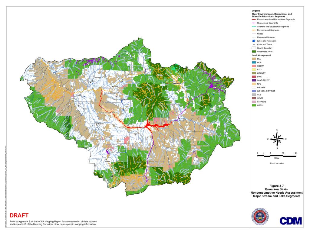
2 Gunnison Basin Environmental and Recreational Nonconsumptive Focus Mapping Background: In 2005, Colorado's legislature established the Water for the 21 st Century Act. This act established an Interbasin Compact Process that provides a permanent forum for broad-based water discussions in the state. It creates two new structures: 1) the Interbasin Compact Committee (IBCC), and 2) the Basin Roundtables. There are nine Basin Roundtables based on Colorado s eight major river basins and the Denver metro area (Figure 1-1). As part of the IBCC, the Basin Roundtables are required to complete basinwide needs assessments. The needs assessments are to include: An assessment of consumptive water needs (municipal, industrial, and agricultural); An assessment of nonconsumptive water needs (environmental and recreational); An assessment of available Figure 1-1 Colorado's Nine Basin Roundtables water supplies (surface and groundwater) and an analysis of any unappropriated waters; and Proposed projects or methods to meet any identified water needs and achieve water supply sustainability over time. The focus area mapping presented here within is part of the Gunnison Basin Roundtable s assessment of nonconsumptive water needs. The development of the focus mapping for environmental and recreational features in the Gunnison Basin was heavily dependent on Basin Roundtable NCNA subcommittee member participation. The following are members of the Gunnison Basin NCNA subcommittee: Tyler Martineau (chair) Marc Catlin Ken Spann David Kanzer Jim Hokit
3 Dixie Luke Steve Glazer Environmental and recreational focus mapping was completed for the following purposes: The maps are intended to serve as a useful guide for water supply planning so that future conflicts over environmental and recreational needs can be avoided; The maps can assist in identifying environmental and recreational water needs status, such as where needs are being met, where additional future study may need to take place, or where implementation projects in the basin are needed; The maps can help basins plan for the water needs of species of special concern so that they do not become federally listed in the future; and The maps can provide opportunity for collaborative efforts for future multi-objective projects. The mapping developed as part of this effort can serve as a tool as the Gunnison Basin Roundtable completes their consumptive needs assessments and NCNAs and begins to identify multi-purpose projects to meet their needs. The NCNA process is not intended to create a water right for the environment and it is not the intent of the process to diminish, impair, or cause injury to existing absolute or conditional water rights. Phase II of the NCNA process will include the following tasks: An examination of next steps for priority focus areas as directed by the Basin Roundtables; Flow evaluations as determined by the Basin Roundtables for focus areas as needed; and Basin Roundtable identification of projects and methods (both structural and nonstructural) to meet their identified nonconsumptive needs. Methodology: The Gunnison Basin developed an Excel spreadsheet matrix that identified reaches within the basin that contained environmental data layers and recreational data layers identified as important, and reaches that had both recreational and environmental data layers present. The Gunnison also identified reaches that had scientific and educational significance. The Basin Roundtable NCNA subcommittee members used maps of the aquatic-dependent data layers in their basin, previously provided to them, to aid in the development of their matrix. The matrix was further refined with BRT input. Results: The Gunnison Basin chose to include waters within the Rocky Mountain Biological Laboratory property as scientific and educational waters. These are highlighted on the map in cyan.
4 Waterbodies shown in purple are those that are known as boating and fishing reaches. Segments highlighted in orange have environmental nonconsumptive water needs. Many of these streams are located within wilderness areas including the Roubideau Special Area and the Dominguez Wilderness. Segments highlighted in red have both environmental and recreational nonconsumptive water needs. This overlap occurs on a large portion of the Gunnison River. The following mapping information for the Gunnison Basin is contained in the remainder of this Appendix: Data sources for GIS data layers used in Gunnison map development Data Matrix for Gunnison Basin Environmental/Recreational/Scientific/Education Reaches Gunnison Basin Major Stream Segment Map
5 NCNA Mapping Data Sources Gunnison Basin GIS Data and Sources SWSI 2 Shapefile Humpback Chub Streams Colorado Pikeminnow Streams Razorback Sucker Streams Federal Critical Habitat Boreal Toad Known Breeding Sites Colorado River Cutthroat Trout Streams Colorado River Cutthroat Trout Lakes Roundtail Chub Streams Bluehead Sucker Streams Bluehead Sucker Lakes Flannelmouth Sucker Streams Flannelmouth Sucker Lakes Rare Riparian/Wetland-Dependent Plants Significant Riparian/Wetland Plant Communities Instream Flow Streams Natural Lake Level Lakes Gold Medal Streams Recreational In-Channel Diversion Structures Audubon Important Bird Areas Additional Data Layers River Otter (Confirmed Sightings) Bald Eagle Active Nestsites Bald Eagle Communal Roost Northern Leopard Frog Flatwater Motorized and Non-motorized Boating Kayaking Reaches Rafting Reaches Colorado Outstanding Waters (Wilderness Area Waters) Eligible/Suitable Wild and Scenic GMUG Wilderness Roubideau Special Area GMUG Wilderness Waters (Dominguez Wilderness) High Recreation Areas Data Source USFWS CNHP CNHP CWCB CWCB CWCB National Audubon Society Data Source (River Otter database) (NDIS) (NDIS) (herp database) CO State Parks Boatable Waters List digitized from list provided by NCNA Committee Sources are listed as: Whitewater of the Southern Rockies, Southwest Paddler digitized from list provided by NCNA Committee digitized from WQCD list National Wild and Scenic Rivers Act polygon shapefile provided by GMUG/NCNA Committee Members polygon shapefile provided by GMUG/NCNA Committee Members digitized from list of stream/river reaches and lakes/reservoirs sighted as "high recreation areas" by NCNA Committee Members Riparian/Wetland Wildlife Viewing Waterfowl Hunting Rocky Mountain Biological Laboratory (scientific and educational reaches) Significant cold and warm-water fishing Digitized from list provided by David Graf () SWA parcels with waterfowl hunting waters within RMBL property boundary digitized from list provided by NCNA Committee Colorado Fishing Network A DRAFT S:\Nonconsumptive\NCNA_Mapping_Report\Apps\Appendix B\Data Sources for NCNA (lb).xlsx
6 GUNNISON BASIN NON CONSUMPTIVE NEEDS ASSESSMENT IDENTIFICATION OF MAJOR STREAM AND LAKE SEGMENTS STREAM OR LAKE SEGMENT (Based upon segment maps) No. Major Environmental & Recreational Segments 1 Blue Mesa, Morrow Point, Crystal Reservoirs and Gunnison River in Curecanti National Recreation Area 2 Gunnison River in Black Canyon of the Gunnison National Park 3 Gunnison River in Gunnison Gorge National Conservation Area down to Confluence with North Fork of the Gunnison River Major Environmental Segments 4 Gunnison River Hartland Diversion to Confluence Colorado River 1 ATTRIBUTE CATEGORY 1. Federally Listed Fish Species (critical habitat and distribution) 2. Aquatic Dependent State Endangered, Threatened, and Species of Concern (including conservation agreement species) 3. Rare Aquatic Dependent Plants and Significant Riparian/Wetland Plant Communities 4. Special Value Waters (CWCB instream flow waters, WQCD Outstanding Waters, Wilderness Area Waters, Eligible/Suitable Wild and Scenic) 5. Whitewater and Flat water Boating 6. Riparian/Wetland Wildlife Viewing and Waterfowl Hunting 7. Significant Cold and Warm Water Fishing 8. High Recreation Areas Total Number of Attributes No. of Environmental Attributes No. of Recreation Attributes RATIONALE FOR CONSIDERATION AS A MAJOR SEGMENT c,d b d a b,c b Highest Flat water Recreation Use, High Water Quality, Environmental, Scientific, and Educational Values c,d,f,g b b,c a a a a National Park Multiple Environmental, Recreational, Scientific and Educational Values c,d,f,g b,c b a a Gold Medal Stream, Multiple Recreational and Environmental Values a,b b,c,d,g b b a Critical Habitat for Federal Endangered Species, Multiple State Aquatic Species of Concern plus Recreation 5 Gunnison River Confluence with North Fork Gunnison River to Hartland Diversion 1 6 North Fork of the Gunnison River Paonia Dam to Confluence with Gunnison River 1 7 Stream Segments on Headwaters Wilderness b,c,d,g b a,b Multiple State Aquatic Species of Concern, Opportunities for Recreation Use b,c,d,f,g a,b b b a b Multiple State Aquatic Species of Concern, Opportunities for Recreation Use a,e a,b a,b,d,e b Multiple Environmental Values plus Recreation Page 1
7 GUNNISON BASIN NON CONSUMPTIVE NEEDS ASSESSMENT IDENTIFICATION OF MAJOR STREAM AND LAKE SEGMENTS ATTRIBUTE CATEGORY 1. Federally Listed Fish Species (critical habitat and distribution) 2. Aquatic Dependent State Endangered, Threatened, and Species of Concern (including conservation agreement species) 3. Rare Aquatic Dependent Plants and Significant Riparian/Wetland Plant Communities 4. Special Value Waters (CWCB instream flow waters, WQCD Outstanding Waters, Wilderness Area Waters, Eligible/Suitable Wild and Scenic) STREAM OR LAKE SEGMENT (Based upon segment maps) RATIONALE FOR CONSIDERATION AS A MAJOR SEGMENT 8 Coal Creek, Slate River and Tributaries 1 Remediation 9 East River Gothic to Almont g,h b b b a b,d Multiple Environmental Values 5. Whitewater and Flat water Boating 6. Riparian/Wetland Wildlife Viewing and Waterfowl Hunting 7. Significant Cold and Warm Water Fishing 8. High Recreation Areas Total Number of Attributes No. of Environmental Attributes No. of Recreation Attributes 10 Henson Creek and Tributaries 1 c b a,b a Opportunities for Environmental Remediation 11 Uncompahgre River and Tributaries Headwaters to Ouray 1 12 Uncompahgre River Ouray to South Canal Outfall and West Canal Flume 1 b b a b Opportunities for Environmental Remediation d,h a,b b b a,b b Opportunities for Environmental Remediation, Recreation Opportunities Major Recreational Segments 13 Grand Mesa Lakes on National Forest a a d c b Highest Recreation and Fishery Use 14 Tributaries to Taylor Park Reservoir a b,a a,b b a Highest Recreation and Fishery Use, Significant Environmental Values 15 Taylor Park Reservoir d a c b Highest Recreation and Fishery Use 16 Taylor River Taylor Park h b b b a Highest Recreation and Fishery Use Reservoir to Almont 17 Gunnison River Almont to Blue Mesa Reservoir c,d b,c b a Highest Recreation and Fishery Use 18 Lake San Cristobal b a d c b Highest Recreation and Fishery Use 19 Lake Fork of the Gunnison River Lake San Cristobal to Blue Mesa Reservoir c,d b b b a b Fishery Needs (Augmentation of Stream Flows Needed) 20 Ridgway Reservoir d,f d a c b Highest Recreation and Fishery Use Major Scientific and Educational Segments Page 2
8 GUNNISON BASIN NON CONSUMPTIVE NEEDS ASSESSMENT IDENTIFICATION OF MAJOR STREAM AND LAKE SEGMENTS ATTRIBUTE CATEGORY 1. Federally Listed Fish Species (critical habitat and distribution) 2. Aquatic Dependent State Endangered, Threatened, and Species of Concern (including conservation agreement species) 3. Rare Aquatic Dependent Plants and Significant Riparian/Wetland Plant Communities 4. Special Value Waters (CWCB instream flow waters, WQCD Outstanding Waters, Wilderness Area Waters, Eligible/Suitable Wild and Scenic) 5. Whitewater and Flat water Boating 6. Riparian/Wetland Wildlife Viewing and Waterfowl Hunting 7. Significant Cold and Warm Water Fishing 8. High Recreation Areas Total Number of Attributes No. of Environmental Attributes No. of Recreation Attributes STREAM OR LAKE SEGMENT (Based upon segment maps) 21 Upper East River and Tributaries Headwaters to Gothic RATIONALE FOR CONSIDERATION AS A MAJOR SEGMENT a,e b a,b a Scientific and Educational Use, Environmental Values Other Segments with Four or More Attributes (Not to Be Included on Major Segments Map) Kannah Creek 1 a,c,d a Crawford Reservoir and c,d b d a c watershed Muddy Creek Headwaters above North Fork of Gunnison River a,f b b Coal & Anthracite Creeks a,d,f b b a b Brush Creek Headwaters a,e b b Cement Creek a,b b a Tributaries to Taylor River below Taylor Park Reservoir a a,b a,b Upper Cochetopa Basin a b b a b Cebolla Creek a,b b a b Tributaries to Lake San a a,b a,b a Cristobal Soap and Curecanti Creeks a b b a b Cimarron River Basin a b a,b a b,c Uncompahgre River Montrose to Confluence Gunnison River 1 b,c,d,f,g b b a Cow Creek (E of Ridgway) a a,b b b Dry Creek (S of Delta) a,c,h b b Roubideau Creek b b,f a Page 3
9 GUNNISON BASIN NON CONSUMPTIVE NEEDS ASSESSMENT IDENTIFICATION OF MAJOR STREAM AND LAKE SEGMENTS ATTRIBUTE CATEGORY 1. Federally Listed Fish Species (critical habitat and distribution) 2. Aquatic Dependent State Endangered, Threatened, and Species of Concern (including conservation agreement species) 3. Rare Aquatic Dependent Plants and Significant Riparian/Wetland Plant Communities 4. Special Value Waters (CWCB instream flow waters, WQCD Outstanding Waters, Wilderness Area Waters, Eligible/Suitable Wild and Scenic) 5. Whitewater and Flat water Boating 6. Riparian/Wetland Wildlife Viewing and Waterfowl Hunting 7. Significant Cold and Warm Water Fishing 8. High Recreation Areas Total Number of Attributes No. of Environmental Attributes No. of Recreation Attributes STREAM OR LAKE SEGMENT (Based upon segment maps) Escalante Creek a c,d,f,g a,b b a a Dominguez Creek a c,d,f a,b b Other Segments (Not to Be Included on Major Segments Map) Surface and Leroux Creeks f,g b Fruitgrowers Reservoir 1 a Terror Creek Headwaters a b b Bell Creek (SW of Paonia) f Smith Fork b Paonia Reservoir d c Tomichi Creek Tributaries b a,b West Antelope Creek a b b South Beaver Creek Headwaters a b Beaver Cr. (W of Gunnison) a b b Red, East Elk, Willow, and b b Steuben Creeks Mill Creek (Curecanti Cr) a Road Beaver Creek a b Big Blue Creek b b b Spring Creek (W of Montrose) a,c b Switzer Lake 1 d a c Buttermilk Creek (SW of Delta c,f Cottonwood Creek (SW of a b a Delta) East Creek (S of Grand Jct) f b KEY TO ATTRIBUTE CODES Page 4 RATIONALE FOR CONSIDERATION AS A MAJOR SEGMENT
10 GUNNISON BASIN NON CONSUMPTIVE NEEDS ASSESSMENT IDENTIFICATION OF MAJOR STREAM AND LAKE SEGMENTS ATTRIBUTE CATEGORY 1. Federally Listed Fish Species (critical habitat and distribution) 2. Aquatic Dependent State Endangered, Threatened, and Species of Concern (including conservation agreement species) 3. Rare Aquatic Dependent Plants and Significant Riparian/Wetland Plant Communities 4. Special Value Waters (CWCB instream flow waters, WQCD Outstanding Waters, Wilderness Area Waters, Eligible/Suitable Wild and Scenic) 5. Whitewater and Flat water Boating 6. Riparian/Wetland Wildlife Viewing and Waterfowl Hunting 7. Significant Cold and Warm Water Fishing 8. High Recreation Areas Total Number of Attributes No. of Environmental Attributes No. of Recreation Attributes STREAM OR LAKE SEGMENT (Based upon segment maps) Attribute 1 Federally Listed Fish Species (critical habitat and distribution) a. Razorback Sucker, Humpback Chub, Colorado Pikeminnow b. Federal Critical Habitat Attribute 2 Aquatic Dependent State Endangered, Threatened, and Species of Concern (including conservation agreement species) a. Colorado River Cutthroat Trout b. Roundtail Chub c. Flannelmouth Sucker d. Bluehead Sucker e. Boreal Toad f. Northern Leopard Frog g. River Otter Sightings h. Bald Eagle Sites Attribute 3 Rare Aquatic Dependent Plants and Significant Riparian/Wetland Plant Communities a. Rare Aquatic Dependent Plants b. Significant Riparian/Wetland Plant Communities Attribute 4 Special Value Waters (CWCB instream flow waters, WQCD Outstanding Waters, Wilderness Area Waters, Eligible/Suitable Wild and Scenic) a. CWCB Natural Lake Levels b. CWCB Instream Flows c. Eligible Wild and Scenic d. WQCD Outstanding Waters e. GMUG Wilderness Area Waters f. Camelback/Roubideau Wilderness Study Area Waters Attribute 5 Whitewater and Flat water Boating a. Kayaking b. Rafting (and Kayaking) c. Recreational In Channel Diversions d. Flat water Boating Attribute 6 Riparian/Wetland Wildlife Viewing and Waterfowl Hunting a. Wildlife Viewing and Waterfowl Hunting b. Audubon Important Bird Areas Attribute 7 Significant Cold and Warm Water Fishing a. Gold Medal Streams RATIONALE FOR CONSIDERATION AS A MAJOR SEGMENT Page 5
11 GUNNISON BASIN NON CONSUMPTIVE NEEDS ASSESSMENT IDENTIFICATION OF MAJOR STREAM AND LAKE SEGMENTS ATTRIBUTE CATEGORY 1. Federally Listed Fish Species (critical habitat and distribution) 2. Aquatic Dependent State Endangered, Threatened, and Species of Concern (including conservation agreement species) 3. Rare Aquatic Dependent Plants and Significant Riparian/Wetland Plant Communities 4. Special Value Waters (CWCB instream flow waters, WQCD Outstanding Waters, Wilderness Area Waters, Eligible/Suitable Wild and Scenic) 5. Whitewater and Flat water Boating 6. Riparian/Wetland Wildlife Viewing and Waterfowl Hunting 7. Significant Cold and Warm Water Fishing 8. High Recreation Areas Total Number of Attributes No. of Environmental Attributes No. of Recreation Attributes STREAM OR LAKE SEGMENT (Based upon segment maps) b. River and Stream Fishing c. Reservoir and Lake Fishing d. Fish Hatchery Attribute 8 High Recreation Areas a. High Recreation Rivers b. High Recreation Lakes and Reservoirs RATIONALE FOR CONSIDERATION AS A MAJOR SEGMENT Notes: 1. All or portion of segment is listed on State 303(d) list of water quality impaired segments 2. Non consumptive environmental and/or recreational attributes exist on virtually all stream and lake segments, whether such attributes are identified herein or not. Exclusion of a segment from this chart does not indicate absence of non consumptive attributes. 3. Attributes associated with the major segments are commonly dependent on conditions in upstream tributary segments. Therefore, the achievement or maintenance of non consumptive attributes depends upon achieving or maintaining necessary values in upstream segments as well as within the major segment itself. Page 6
12
DOLORES RIVER NATIVE FISH HABITAT RECOMMENDATIONS AND ALTERNATIVES TO WILD AND SCENIC DESIGNATION
 DOLORES RIVER NATIVE FISH HABITAT RECOMMENDATIONS AND ALTERNATIVES TO WILD AND SCENIC DESIGNATION Prepared by: Colorado Department of Natural Resources Southwest Aquatic Section-DOW Southwest Wildlife
Amendment to a Biological Assessment/Evaluation completed for the Coon Creek Land Disposal completed December Grand Valley Ranger District
 Amendment to a Biological Assessment/Evaluation completed for the Coon Creek Land Disposal completed December 2007 Grand Valley Ranger District Grand Mesa, Uncompahgre, Gunnison National Forests Prepared
July 11, Mr. Mike King Executive Director Colorado Department of Natural Resources 1313 Sherman Street, Room 718 Denver, CO 80203
 July 11, 2014 Mr. Mike King Executive Director Colorado Department of Natural Resources 1313 Sherman Street, Room 718 Denver, CO 80203 Subject: Upper Colorado River Endangered Fish Recovery Program Water
IN THE DISTRICT COURT IN AND FOR WATER DIVISION NO. 4 STATE OF COLORADO TO: ALL PERSONS INTERESTED IN WATER APPLICATIONS IN SAID WATER DIVISION NO.
 IN THE DISTRICT COURT IN AND FOR WATER DIVISION NO. 4 STATE OF COLORADO TO: ALL PERSONS INTERESTED IN WATER APPLICATIONS IN SAID WATER DIVISION NO. 4 Pursuant to C.R.S. 37-92-302, as amended, you are notified
FY 2015 ANNUAL PROJECT REPORT PROJECT NUMBER: 163
 COLORADO RIVER RECOVERY PROGRAM RECOVERY PROGRAM FY 2015 ANNUAL PROJECT REPORT PROJECT NUMBER: 163 I. Project Title: Monitoring multi-life stages of the fish community in the lower Gunnison and upper Colorado
Lower Dolores River Corridor Planning Meeting Jim White Colorado Division of Wildlife
 Lower Dolores River Corridor Planning Meeting Jim White Colorado Division of Wildlife Objectives Overview of cold and warm water fishes in the Dolores River including: Flow and Fish Management Distribution
1.Mill Creek Watershed Summary Description and Land Use
 1.Mill Creek Watershed Summary Description and Land Use Table xxx: Mill Creek Watershed Overview Watershed Size 31,435 acres/49.1 sq miles/ 127.1 sq km Elevation Range 5,594 feet [4,967-10,561] Stream
DRAFT MEMORANDUM TO FILE
 FROM: SUBJECT: DRAFT MEMORANDUM TO FILE Unique Stream Segment Committee File [NTD02182] T:\Task 8 - Unique Designations and Regulatory Issues\Draft Committee Memo.doc Summary of Regional Water Planning
I. Project Title: Annual Operation and Maintenance of the Fish Passage Structure at the Government Highline Diversion Dam on the Upper Colorado River
 COLORADO RIVER RECOVERY PROGRAM FY 2011 ANNUAL PROJECT REPORT RECOVERY PROGRAM PROJECT NUMBER: C4b-GVP I. Project Title: Annual Operation and Maintenance of the Fish Passage Structure at the Government
I. Project Title: Annual Operation and Maintenance of the Fish Passage Structure at the Redlands Diversion Dam on the Gunnison River
 COLORADO RIVER RECOVERY PROGRAM FY 2017 ANNUAL PROJECT REPORT RECOVERY PROGRAM PROJECT NUMBER: C4-b-RED I. Project Title: Annual Operation and Maintenance of the Fish Passage Structure at the Redlands
Proposed Reclassification of Muskrat Creek, North Platte River Basin in Goshen County, Wyoming
 Proposed Reclassification of Muskrat Creek, North Platte River Basin in Goshen County, Wyoming October 25, 2010 Waterbody: Muskrat Creek - Mainstem of Muskrat Creek from its headwaters downstream to its
California Steelhead: Management, Monitoring and Recovery Efforts
 California Steelhead: Management, Monitoring and Recovery Efforts Jonathan Nelson Steelhead Restoration & Management Program Oncorhynchus mykiss irideus California Steelhead Distinct Population Segments
Native Fish of the Lower Dolores River Status, Trends, and Recommendations
 Native Fish of the Lower Dolores River Status, Trends, and Recommendations Dan Kowalski Jim White Rick Anderson Barry Nehring Native Fish of the Dolores River Native Fish Species Current Status and Trends
Draft Central Valley Salmon and Steelhead Recovery Plan
 Draft Central Valley Salmon and Steelhead Recovery Plan for Sacramento River winter-run Chinook salmon Central Valley spring-run Chinook Salmon Central Valley Steelhead National Marine Fisheries Service
Instream Flow Segments In the Wind/Bighorn Basin. Paul Dey Wyoming Game and Fish Department
 Instream Flow Segments In the Wind/Bighorn Basin Paul Dey Wyoming Game and Fish Department WGFD Mission: Conserving Wildlife - Serving People Fish Division Mission As stewards of Wyoming s aquatic resources,
Riverine Fish Flow Investigations
 Riverine Fish Flow Investigations Federal Aid Project F-288-R8 Richard Anderson Principal Investigator Bruce McCloskey, Director Federal Aid in Fish and Wildlife Restoration Job Progress Report Colorado
Instream Flow Water Rights in the Snake and Salt River Basins. Paul Dey, Wyoming Game and Fish Department
 Instream Flow Water Rights in the Snake and Salt River Basins Paul Dey, Wyoming Game and Fish Department Snake/Salt River Basin Instream Flow Water Rights Basis for instream flow work Segments, quantities,
Wildlife Introduction
 Wildlife Introduction The wildlife section of this chapter is divided into sections for various habitats and groups of species. Old growth, snags and downed wood, and riparian areas are unique habitats
Proposed Reclassification of Cherry Creek, North Platte River Basin, Wyoming. October 25, 2010
 Proposed Reclassification of Cherry Creek, North Platte River Basin, Wyoming October 25, 2010 Waterbody: Location: Tributary to: Cherry Creek - Mainstem from headwaters downstream to the confluence with
FISH PASSAGE IMPROVEMENT in California s Watersheds. Assessments & Recommendations by the Fish Passage Forum
 FISH PASSAGE IMPROVEMENT in California s Watersheds Assessments & Recommendations by the Fish Passage Forum FISH PASSAGE IMPROVEMENT in California s Watersheds The mission of the Fish Passage Forum is
Maryland Chapter Trout Unlimited Brook Trout Conservation Effort
 Maryland Chapter Trout Unlimited Brook Trout Conservation Effort Photo by Matt Kline Portfolio of Recent Work MDTU Brook Trout Conservation Coordinator: Scott C. Scarfone, ASLA sscarfone@oasisdesigngroup.com
BLM Cottonwood Field Office ATTN: Draft RMP/EIS 1 Butte Drive Cottonwood, ID Submitted Via to:
 Kevin Colburn National Stewardship Director American Whitewater 1035 Van Buren St. Missoula, MT 59802 406-543-1802 Kevin@amwhitewater.org BLM Cottonwood Field Office ATTN: Draft RMP/EIS 1 Butte Drive Cottonwood,
UPPER GALLATIN TMDL PLANNING AREA BIOLOGICAL MONITORING
 UPPER GALLATIN TMDL PLANNING AREA BIOLOGICAL MONITORING Sampling and Analysis Plan Prepared for: BLUE WATER TASK FORCE, INC. Katie Alvin PO Box 160513 Big Sky, MT 59716 AND MONTANA DEPARTMENT OF ENVIRONMENTAL
Searsville Dam Removal
 Searsville Dam Removal A unique opportunity for all Presented by the Beyond Searsville Dam Coalition San Francisquito Creek flows into the San Francisco Bay near the Palo Alto Airport and Golf Course seen
Aquatic Biological Assessment. Lassen 15 Restoration Project. Modoc National Forest Warner Mountain Ranger District
 Aquatic Biological Assessment Lassen 15 Restoration Project Modoc National Forest Warner Mountain Ranger District Prepared By:_/s/ Marty Yamagiwa Date: December 10, 2015 Marty Yamagiwa, Natural Resources
Don Pedro Project Relicensing
 Don Pedro Project Relicensing M ODESTO I RRIGATION D ISTRICT TURLOCK I RRIGATION D ISTRICT FERC PROJECT N O. 2299 Resident Fish in Don Pedro Reservoir Don Pedro Reservoir Fish Stocking (1971-Present) CDFG
State of San Francisco Bay 2011 Appendix O Steelhead Trout Production as an Indicator of Watershed Health
 State of San Francisco Bay 2011 Appendix O Steelhead Trout Production as an Indicator of Watershed Health Gordon Becker and Katherine Smetak, Center for Ecosystem Management and Restoration 290 Introduction
ES1 - Rivers, Creeks and Streams
 Legend: = Default regulations for Fish Management Zone ES1. As examples 3 over 63 indicates a possession and a size limit and 3 or 10 indicates a possession limit for that species of any size. Watershed
The approach of CanoeKayak BC Whitewater (CKBC-WW) to River Access issues is driven by the organizational Mission Statement:
 to River Access issues is driven by the organizational Mission Statement:") CanoeKayak BC - Whitewater DRAFT RIVER ACCESS POLICY For Comment The approach of CanoeKayak BC Whitewater (CKBC-WW) to River Access issues is driven by the organizational Mission Statement: Provide structure
CanoeKayak BC - Whitewater DRAFT RIVER ACCESS POLICY For Comment The approach of CanoeKayak BC Whitewater (CKBC-WW) to River Access issues is driven by the organizational Mission Statement: Provide structure
Chagrin River TMDL Appendices. Appendix F
 Appendix F The following are excerpts from the Eastern Brook Trout Joint Venture s Conservation Strategy (Working Draft v.6), Conserving the Eastern Brook Trout: Strategies for Action Found at: http://www.easternbrooktrout.org/constrategy.html
Mining & Petroleum Focus Group Southern Rocky Mountain Management Plan. Synopsis of Focus Group Key Issues
 Southern Rocky Mountain Management Plan Page 1 of 6 Synopsis of Focus Group Key Issues Sectors who brought forth issues are listed after the issue in brackets. I. Timeline Completing the plan by June,
TWO FORKS RANCH A5 REAL ESTATE. 790 Acres. Smiths Fork - Lincoln County - Wyoming
 TWO FORKS RANCH 790 Acres Smiths Fork - Lincoln County - Wyoming A5 REAL ESTATE WWW.A5REALESTATE.COM QUICK FACTS Located in the upper Smiths Fork drainage of Lincoln County, Wyoming, the Two Forks Ranch
BUILDING DEPARTMENT VALUATION AND FEES MONTHLY REPORT
 MAY BUILDING DEPARTMENT VALUATION AND FEES MONTHLY REPORT $8,000,000 $7,000,000 $6,000,000 $5,000,000 $4,000,000 $3,000,000 $2,000,000 $1,000,000 $0 $7,337,794 Valuation $1,957,965 UP 74.7% May-2015 May-2014
U.S. Fish and Wildlife Service Native American Crosscut Funding
 U.S. Fish and Wildlife Service Native American Crosscut Funding Tribal / Interior Budget Council National Budget Meeting L Enfant Plaza Hotel Washington, DC November 8, 2013 U.S. Fish and Wildlife Service
WILD AND SCENID ELIGIBILITY ANALYSIS FOR RECREATION San Juan Forest and BLM
 WILD AND SCENID ELIGIBILITY ANALYSIS FOR RECREATION San Juan Forest and BLM Draft 5/3/06 I. Region of comparison: The interdisciplinary team must identify the area of consideration that will serve as the
Eastern Brook Trout Joint Venture Completed Project Report Form
 Eastern Brook Trout Joint Venture Completed Project Report Form Project Title: Assessing the Efficacy of Remediating Episodic Low ph (and High Aluminum) Concentrations in Headwater Brook Trout Streams
1.Warm Springs Creek (Anaconda) Watershed Description and Land Use
 Watershed Description and Land Use") 1.Warm Springs (Anaconda) Watershed Description and Land Use Table xxx: Warm Springs Watershed Overview Watershed Size 92,288 acres/144.2 sq miles/373.6 sq km Elevation Range 5,781 feet [4,800-10,581]
1.Warm Springs (Anaconda) Watershed Description and Land Use Table xxx: Warm Springs Watershed Overview Watershed Size 92,288 acres/144.2 sq miles/373.6 sq km Elevation Range 5,781 feet [4,800-10,581]
Table xxx: Listed and Suspected Impairments for Willow Creek 2010 Reach Impairment Pollutant Impaired Uses
 1. (Fairmont) Watershed Summary Description and Land Use Table xxx: (Fairmont) Watershed Overview Watershed Size 18,331 acres/28.7 sq miles/74.3 sq km Elevation Range 2,615 feet [4,980-7,595] Stream Miles
March 12, Submitted to: Re: Wild and Scenic River Eligibility Study. Dear Planning Team,
 www.americanwhitewater.org Kevin Colburn National Stewardship Director PO Box 1540 Cullowhee, NC 28723 828-712-4825 kevin@americanwhitewater.org March 12, 2018 Submitted to: scnf_plan_rev@fs.fed.us Re:
Executive Summary. Map 1. The Santa Clara River watershed with topography.
 Santa Clara River Steelhead Trout: Assessment and Recovery Opportunities December 2005 Prepared By: Matt Stoecker and Elise Kelley, Ph.D. University of California, Santa Barbara Prepared For: The Santa
NEVADA DEPARTMENT OF WILDLIFE STATEWIDE FISHERIES MANAGEMENT
 NEVADA DEPARTMENT OF WILDLIFE STATEWIDE FISHERIES MANAGEMENT FEDERAL AID JOB PROGRESS REPORTS F-20-52 2016 Lake Tahoe Rainbow Trout Study WESTERN REGION NEVADA DEPARTMENT OF WILDLIFE, FISHERIES DIVISION
California Steelhead: Management, Monitoring and Recovery Efforts
 California Steelhead: Management, Monitoring and Recovery Efforts Jonathan Nelson Steelhead Management, Research and Restoration Program Oncorhynchus mykiss irideus California Steelhead - Hot Topics Implementation
IMPLEMENTATION, MONITORING & EVALUATION PLAN OVERVIEW
 LOWER DOLORES RIVER IMPLEMENTATION, MONITORING & EVALUATION PLAN OVERVIEW Improving the Health of Na ve Fish and Protec ng Water Supplies: An Ac on Plan Photo: John Fielder Photo: Sam Green, Cortez Journal
MONTROSE COUNTY. CASE NO. 2013CW58.
 IN THE DISTRICT COURT IN AND FOR WATER DIVISION NO. 4 STATE OF COLORADO TO: ALL PERSONS INTERESTED IN WATER APPLICATIONS IN SAID WATER DIVISION NO. 4 Pursuant to C.R.S. 37-92-302, as amended, you are notified
Little Kern Golden Trout Status:
 Little Kern Golden Trout Status: The Little Kern Golden trout (LKGT) was proposed for federal listing as Threatened under the Endangered Species Act (ESA) on September 1, 1977 by the U. S. Fish and Wildlife
Analysis Data Sources
 Page Technical Appendix D 1 SMP Analysis Data Sources the set bathymetry levee riprap mine lakebath_arc FloodHazardD ata.mdb\flood HazardZoneCo mponents\fhcl evee FloodHazardD ata.mdb\flood HazardZoneCo
5B. Management of invasive species in the Cosumnes and Mokelumne River Basins
 5B. Management of invasive species in the Cosumnes and Mokelumne River Basins Cosumnes River The Cosumnes River basin has a number of distinct habitat types that require different management strategies
FINAL Caples Lake Fisheries Management Plan. Version 4.0
 FINAL Caples Lake Fisheries Management Plan Version 4.0 August 15, 2008 Purpose The Caples Lake Fisheries Management Plan (Plan) outlines the stocking plan to reestablish a sport fishery in Caples Lake
Swift Current Creek Watershed
 Swift Current Creek Watershed Watershed Boundary Gross drainage area 3939 km 2 973,343 acres Gross creek length 230 km 143 miles Primary water source for 20 000 people Major source of water base recreation
FY 2010 ANNUAL PROJECT REPORT PROJECT NUMBER: FR- 115
 COLORADO RIVER RECOVERY PROGRAM RECOVERY PROGRAM FY 21 ANNUAL PROJECT REPORT PROJECT NUMBER: FR- 1 I. Project Title: Cumulative Effects of Flaming Gorge Dam Releases, since 1996, on the Fish Community
Proposed Reclassification of Deer Creek, North Platte River Basin, Wyoming
 Proposed Reclassification of Deer Creek, North Platte River Basin, Wyoming October 25, 2010 Waterbody: Location: Tributary to: Deer Creek - Mainstem from headwaters downstream to the confluence with the
The Blue Heron Slough Conservation Bank
 1 The Blue Heron Slough Conservation Bank CONSERVATION BANKING July 19-23, 2010 CASE STUDY SERIES The Blue Heron Slough Conservation Bank (Washington) I. OVERVIEW & BACKGROUND: Location: Snohomish River
Catlow Valley Redband Trout
 Catlow Valley Redband Trout Existing Populations The Catlow Valley Redband Trout SMU is comprised of five populations (Table 1). Three exist in Home, Threemile, and Skull creeks, located on the east side
I. Project Title: Monitoring effects of Flaming Gorge Dam releases on the Lodore and Whirlpool Canyon fish communities
 COLORADO RIVER RECOVERY PROGRAM FY 213 ANNUAL PROJECT REPORT RECOVERY PROGRAM PROJECT NUMBER: FR-11 I. Project Title: Monitoring effects of Flaming Gorge Dam releases on the Lodore and Whirlpool Canyon
ARKANSAS RIVER, LAKE FORK
 ARKANSAS RIVER, LAKE FORK 2012 The station just below County Road 11 (LF1) is routinely sampled as part of the protocol to monitor fish population changes relative to heavy metal cleanup in the Leadville
Beaver Valley Ranch Steamboat Springs, Colorado
 Beaver Valley Ranch Steamboat Springs, Colorado Introduction Hidden in the heart of one of Colorado s last unspoiled mountain valleys, Beaver Valley Ranch is tailor-made for hunting and fishing of exceptional
2017 Fishing Forecast
 Colorado Parks and Wildlife SOUTHWEST REGION AQUATIC SECTION 2017 Fishing Forecast Dan Brauch, Aquatic Biologist Gunnison Eric Gardunio, Aquatic Biologist-Montrose Estevan Vigil, Aquatic Biologist - Monte
Orange County MARINE PROTECTED AREAS 2 nd Quarter 2016 Report
 Orange County MARINE PROTECTED AREAS 2 nd Quarter 2016 Report Page 1 of 7 WHAT IS THE OC MPA WATCH PROGRAM? The Orange County Marine Protected Area (OC MPA) Watch Program enlists volunteers, community
Fish at the table and in the river: Nearing a quarter-century in the Upper Colorado River Endangered Fish Recovery Program
 Fish at the table and in the river: Nearing a quarter-century in the Upper Colorado River Endangered Fish Recovery Program Angela Kantola Deputy Program Director Partners State of Colorado State of Utah
Cutthroat trout genetics: Exploring the heritage of Colorado s state fish
 Cutthroat trout genetics: Exploring the heritage of Colorado s state fish Metcalf et al. 2007 Molecular Ecology Metcalf et al. 2007 From Metcalf et al. 2007 But what about this one? Metcalf et al. 2007
Powder/Tongue River Basin Plan Available Surface Water Determination Task 3D
 Technical Memorandum Subject: Powder/Tongue River Basin Plan Available Surface Water Determination Task 3D Date: February 2002 Prepared by: HKM Engineering Inc. INTRODUCTION Spreadsheet water accounting
COLORADO RIVER RECOVERY PROGRAM RECOVERY PROGRAM FY 2015 ANNUAL PROJECT REPORT PROJECT NUMBER: 160
 COLORADO RIVER RECOVERY PROGRAM RECOVERY PROGRAM FY 215 ANNUAL PROJECT REPORT PROJECT NUMBER: 16 I. Project Title: Assessment of Stocked Razorback Sucker Reproduction in the Lower Green and Lower Colorado
Utah. North Stansbury Mountains Wilderness Study Area Site-Specific Monitoring Guide
 Utah North Stansbury Mountains Wilderness Study Area Site-Specific Monitoring Guide 1 General Information WildSNAP Monitoring Peter Woodruff, American Conservation Experience Coordinator Phone (801) 989-7069
I. Project Title: Upper Yampa River northern pike management and monitoring
 COLORADO RIVER RECOVERY PROGRAM FY 217 ANNUAL PROJECT REPORT RECOVERY PROGRAM PROJECT NUMBER: 98b I. Project Title: Upper Yampa River northern pike management and monitoring II. Bureau of Reclamation Agreement
Trip Report: Eagle Creek, Arizona
 Trip Report: Eagle Creek, Arizona 15-17 June 2009 Participants: Abraham Karam, Brian Kesner, and Mike Childs Native Fish Lab Marsh & Associates, LLC 5016 South Ash Avenue Suite 108 Tempe, Arizona 85282
 SOUTHWEST REGION 2003 2004 2005 2006 2007 2008 2009 2010 2011 2012 2013 2014 RIDGWAY REVENUE 2003-2014 1,000,000.00 900,000.00 800,000.00 700,000.00 600,000.00 500,000.00 400,000.00 300,000.00 200,000.00
NEVADA DEPARTMENT OF WILDLIFE STATEWIDE FISHERIES MANAGEMENT
 NEVADA DEPARTMENT OF WILDLIFE STATEWIDE FISHERIES MANAGEMENT FEDERAL AID JOB PROGRESS REPORTS F-20-52 2016 REDBAND TROUT EASTERN REGION NEVADA DEPARTMENT OF WILDLIFE, FISHERIES DIVISION ANNUAL JOB PROGRESS
Black Sturgeon Regional Plan
 Black Sturgeon Regional Plan This is one of twenty Regional Plans that support implementation of the Lake Superior Biodiversity Conservation Strategy (Strategy). The Strategy, prepared and overseen by
Teton County Related Hunting and Fishing Spending, For the Wyoming Wildlife Federation. David T. Taylor & Thomas Foulke
 Teton County Related Hunting and Fishing Spending, 2015 For the Wyoming Wildlife Federation University of Wyoming, Department of Agricultural & Applied Economics David T. Taylor & Thomas Foulke 1 February
Volume I: Ecological Attributes of the San Francisco Bay-Delta Watershed
 XIII. APPENDIX: Summation of Calfed Bay-Delta Program Ecosystem Restoration Program Plan Volumes I and II Visions and Actions Related to Battle Creek Biological Resources as Affected by Facilities and
Current Wild Trout Classification Overview and Listing Process
 Current Wild Trout Classification Overview and Listing Process Pennsylvania Wild Trout Summit David Nihart - PFBC August 26, 2017 Wild Trout Programs Wild Trout Waters (Natural Reproduction) Class A Wild
ESTABLISHING A TROUT FISHERY IN MILL CREEK
 ESTABLISHING A TROUT FISHERY IN MILL CREEK PROJECT OVERVIEW ANNARBOR CHAPTER OF TROUT UNLIMITED MILL CREEK FISHERY DEVELOPMENT COMMITTEE Discussion Agenda Project background and goals Project description
Orange County MARINE PROTECTED AREAS 3 rd Quarter 2015 Report
 Orange County MARINE PROTECTED AREAS 3 rd Quarter 2015 Report Page 1 of 7 WHAT IS THE OC MPA WATCH PROGRAM? The Orange County Marine Protected Area (OC MPA) Watch Program enlists volunteers, community
At Home on the Elbow River. -Ours to share-
 At Home on the Elbow River -Ours to share- Living in the shed You are part of the Elbow River Watershed. The Elbow River and its tributaries drain over 1,200 km² of land. The source of the Elbow River
WFC 50 California s Wild Vertebrates Jan. 11, Inland Waters (Lakes and Streams) Lisa Thompson
 Lisa Thompson") Inland Waters: Lakes and Streams WFC 50 11 January 2011 Lisa Thompson Fisheries Extension Specialist Wildlife, Fish, & Conservation Biology Department University of California, Davis Take home messages
Inland Waters: Lakes and Streams WFC 50 11 January 2011 Lisa Thompson Fisheries Extension Specialist Wildlife, Fish, & Conservation Biology Department University of California, Davis Take home messages
Report submitted by Trout Unlimited to U.S. Bureau of Land Management per Cooperative Agreement PAA
 A Landscape-based Protocol to Identify Management Opportunities for Aquatic Habitats and Native Fishes on Public Lands, Phase II: Upper Colorado River Basin Daniel C. Dauwalter, Helen M. Neville, and Jack
TABLE OF CONTENTS LIST OF TABLES NONE LIST OF FIGURES NONE
 TABLE OF CONTENTS 7.4 RIVER-RELATED RECREATION SURVEYS (REC 4)... REC 4-1 7.4.1 Study Objectives... REC 4-1 7.4.2 Study Area... REC 4-1 7.4.3 Methods... REC 4-1 7.4.4 Key Questions... REC 4-3 7.4.5 Results...
NEVADA DEPARTMENT OF WILDLIFE STATEWIDE FISHERIES MANAGEMENT
 NEVADA DEPARTMENT OF WILDLIFE STATEWIDE FISHERIES MANAGEMENT FEDERAL AID JOB PROGRESS REPORT F-20-50 2014 LAHONTAN CUTTHROAT TROUT STUDY WESTERN REGION NEVADA DEPARTMENT OF WILDLIFE, FISHERIES DIVISION
Fly Fisher s Quick Reference Guide to the Gunnison Valley
 Fly Fisher s Quick Reference Guide to the Gunnison Valley By John Bocchino Fly Fisher s Quick Reference Guide to the Gunnison Valley By John Bocchino Copyright 2015 John Bocchino All Rights Reserved. John
COLORADO RIVER RECOVERY PROGRAM RECOVERY PROGRAM FY 2018 ANNUAL PROJECT REPORT PROJECT NUMBER: 169
 COLORADO RIVER RECOVERY PROGRAM RECOVERY PROGRAM FY 2018 ANNUAL PROJECT REPORT PROJECT NUMBER: 169 I. Project Title: Detecting endangered fishes using PIT tag antenna technology in the Upper Colorado River
Proposed 2018 Fisheries Management Measures to Support Recovery of Interior Fraser River Steelhead
 Proposed 2018 Fisheries Management Measures to Support Recovery of Interior Fraser River Steelhead 22-March-2018 Spawning escapements of two Interior Fraser River steelhead stocks, Thompson and Chilcotin
NEVADA DEPARTMENT OF WILDLIFE STATEWIDE FISHERIES MANAGEMENT
 NEVADA DEPARTMENT OF WILDLIFE STATEWIDE FISHERIES MANAGEMENT FEDERAL AID JOB PROGRESS REPORTS F-20-49 2013 LAKE TAHOE WESTERN REGION NEVADA DEPARTMENT OF WILDLIFE, FISHERIES DIVISION ANNUAL PROGRESS REPORT
Peace River Water Use Plan. Monitoring Program Terms of Reference. GMSMON-1 Peace River Creel Survey
 Peace River Water Use Plan Monitoring Program Terms of Reference GMSMON-1 Peace River Creel Survey April 10, 2008 Terms of Reference for the Peace River Water Use Plan Monitoring Program: Peace River Creel
Alberta Conservation Association 2017/18 Project Summary Report
 Alberta Conservation Association 2017/18 Project Summary Report Project Name: Abundance, Distribution, Spawning, and Thermal Habitat of Westslope Cutthroat Trout and Bull Trout in the Stimson Creek Watershed
Orange County MPA Watch Program Quarterly Report (Jan 1 March 31, 2012)
") Orange County MPA Watch Program Quarterly Report (Jan 1 March 31, 2012) What is the OC MPA Watch Program? The Orange County Marine Protected Area (OC MPA) Watch Program enlists volunteers, community groups
Orange County MPA Watch Program Quarterly Report (Jan 1 March 31, 2012) What is the OC MPA Watch Program? The Orange County Marine Protected Area (OC MPA) Watch Program enlists volunteers, community groups
Trout Unlimited Comments on the Scope of Environmental Impact Statement for the Constitution Pipeline Project, Docket No. PF12-9
 October 9, 2012 Kimberly D. Bose, Secretary Federal Energy Regulatory Commission 888 First Street, NE, Room 1A Washington, DC 20426 RE: Trout Unlimited Comments on the Scope of Environmental Impact Statement
Klickitat County Shoreline Master Program Update. Open House March 15, 2017
 Klickitat County Shoreline Master Program Update Open House March 15, 2017 Agenda 6:00 6:10 Welcome 6:10 6:40 Presentation SMP Update Process Shoreline Analysis review 6:40 8:00 Open House Topics SMP Process
The Lake Creek Ranch. Located in the foothills of the Owl Creek Mountains in western Hot Springs County, Wyoming
 The Lake Creek Ranch Located in the foothills of the Owl Creek Mountains in western Hot Springs County, Wyoming Experienced Professional Ranch Brokers Specializing in the sale of ranches, farms, & recreational
Module 2 Narration What is a watershed?
 Module 2 Narration What is a watershed? Timing Key Narrative Snapshots a) 00:10 Every living thing relies on water to exist. But where does our water come from? The most natural place to look is upstream
Trail Proposal #1; May 14, 2005
 Trail Proposal #1; May 14, 2005 Dennis Kaltenbruner Bow Cycle Dean Cockshutt Mountain Toys Dave Sheridan GPS map Coord. Plus many others! Rocky Mountain Dirt Riders Association (RMDRA), on behalf of all
Rethinking the mountain experience.
 Rethinking the mountain experience. Cimarron Mountain Club is comprised of 12 spectacular ranches at the edge of the Uncompahgre Wilderness, between Telluride and Crested Butte. The ranches share world-class
Example Applications
 Example Applications The following example applications are intended to present how the tools developed for Trout Unlimited s Brook Trout Conservation Portfolio and Range-wide Assessment of Habitat Condition
KOOCANUSA KOKANEE ENUMERATION (2003) Prepared by: W. T. Westover Fisheries Biologist
 Prepared by: W. T. Westover Fisheries Biologist") KOOCANUSA KOKANEE ENUMERATION (2003) Prepared by: W. T. Westover Fisheries Biologist Ministry of Water, Land and Air Protection 205 Industrial Road G, Cranbrook, B. C. V1C 7G5 December, 2003 INTRODUCTION
KOOCANUSA KOKANEE ENUMERATION (2003) Prepared by: W. T. Westover Fisheries Biologist Ministry of Water, Land and Air Protection 205 Industrial Road G, Cranbrook, B. C. V1C 7G5 December, 2003 INTRODUCTION
Oregon Administrative Rules Oregon Department of Fish and Wildlife
 DIVISION 500 Fish Management Plans 635-500-0002 Purpose The administrative rules contained in this division are the legally enforceable elements of fish management plans. Fish management plans are comprehensive
Southern Oregon Coastal Cutthroat Trout
 Species Management Unit Description Southern Oregon Coastal Cutthroat Trout The Southern Oregon Coastal Cutthroat Trout SMU includes all populations of cutthroat trout inhabiting ocean tributary streams
Funding Habitat Restoration Projects for Salmon Recovery in the Snake River Region SRFB Grant Round Version: 2/19/16
 2016 SRFB Grant Round Version: 2/19/16 Funding Habitat Restoration Projects for Salmon Recovery in the Snake River Region The Project Funding Process Presented by the Snake River Salmon Recovery Lead Entity
JC Mesa Ranch. Colorado - San Miguel County - Telluride
 Commanding stunning views of Telluride and surrounding peaks, the 2,379 deeded-acre JC Mesa Ranch is one of the only remaining undeveloped and unencumbered ranches in the Telluride area. Surrounded by
Water in the Deschutes Who needs it?
 Water in the Deschutes Who needs it? Rivers and streams over appropriation and flow alteration. Junior water right holders production agriculture. The Cities long-term supply for growing populations. Climate
Wyoming Game and Fish Department
 Wyoming Game and Fish Department Pinedale Region Newsletter Pinedale Hosts A Picnic Several staff members from the Pinedale Region gathered on a Saturday afternoon in June to hold a public appreciation
Project Name: Distribution and Abundance of the Migratory Bull Trout Population in the Castle River Drainage (Year 4 of 4)
") Alberta Conservation Association (ACA) Date: 2014-2015 Project Name: Distribution and Abundance of the Migratory Bull Trout Population in the Castle River Drainage (Year 4 of 4) Fisheries Program Manager:
Alberta Conservation Association (ACA) Date: 2014-2015 Project Name: Distribution and Abundance of the Migratory Bull Trout Population in the Castle River Drainage (Year 4 of 4) Fisheries Program Manager: