Assessment of Moat Creek Fisheries and Prospects for Restoration
|
|
|
- Bertram York
- 5 years ago
- Views:
Transcription
1 Assessment of Moat Creek Fisheries and Prospects for Restoration Prepared for: Moat Creek Management Agency P.O. Box 423 Pt. Arena, California By: Patrick Higgins Consulting Fisheries Biologist 791 Eighth Street, Suite N Arcata, California 95521
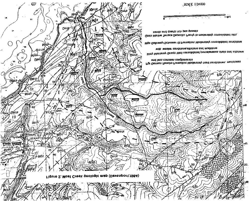
2 Table of Contents Section Page Executive Summary 1 Introduction 1 Methods 2 Fisheries Investigations 2 Assessment of Recovery From Bentonite Spill Impacts 3 Determining Stream Conditions Limiting Salmonid Production 3 Relationship of Watershed Geology to Salmonid Production 5 Alternative Course Offered For Fisheries Restoration 6 Conclusion 7 Acknowledgements 8 References 8 Photos 10 Figures Figure 1. Moat Creek Watershed Map Showing Reaches and Key Locations Figure 2. Moat Creek Geologic Map 1a 5a
3 Executive Summary Moat Creek is a small coastal stream flowing into the Pacific Ocean just south of Point Arena. A fisheries resources assessment was conducted to determine whether the creek had completely recovered from the impacts of a bentonite spill that occurred in August 1992 and to determine what measures might be implemented to improve and restore salmon or steelhead runs. While the stream has fully recovered from spill impacts, it seems that Moat Creek never supported salmonids because of natural geologic conditions in the watershed. However, a very diverse amphibian population is indicative of restored stream health. The goal of restoring or improving salmonids in Moat Creek proved infeasible; therefore, an alternative proximate watershed is recommended for expenditure of funds dedicated to fisheries restoration. Moat Creek could still serve as an interesting natural history study site for local schools. Introduction In August 1993 a field assessment of Moat Creek was conducted to determine the status of fisheries and other aquatic resources in Moat Creek, a second order stream that flows into the Pacific Ocean just south of Point Arena. The stream was the site of a bentonite spill in August 1992 (Higgins, 1992) and study objectives included assessment of recovery from spill impacts and determination of restoration measures to help restore coho salmon (Oncorhynchus kisutch) and steelhead (O. mykiss) populations in the basin, if possible. A geologic investigation of the watershed was subsequently conducted in November The headwaters of Moat Creek arise in the Coast Range about three miles inland. The basin area is just under three square miles and the maximum elevation in the watershed is about 1,000 feet. While rainfall occurs mostly between October and May, aquifers in headwater areas feed small amounts of cool water into the stream during dry periods. Stream temperatures were measured at 53 F in headwater areas, while lower reaches and the lagoon were 60 and 62 F, respectively. Surface flow may be lost in some portions of the stream during prolonged periods of dry weather but aquatic life is retained in pool habitats. Moat Creek can be logically divided into four reaches: steep headwaters, a low gradient reach in the vicinity of Curly Lane, a short higher gradient reach, above the Hay Ranch, and the flat, alluvial reach in agricultural land that extends about one mile to the ocean (Figure 1). The South Fork of Moat Creek was not surveyed but would constitute a fifth stream reach. The canopy of the stream is quite dense in most reaches with coastal redwood and Douglas fir shading upper reaches and red alder and willow dominating the riparian of milder gradient reaches. Silk tassel, 1
4
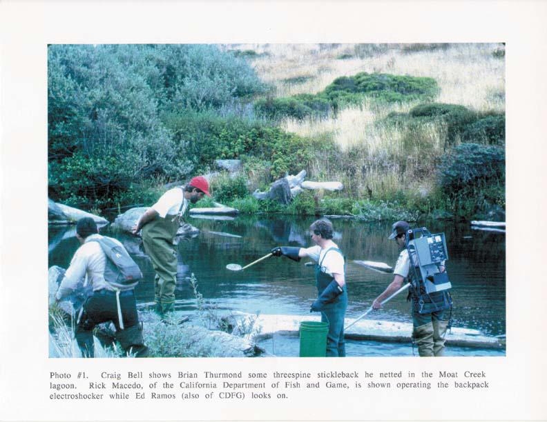
5 sword fern and bracken fern provide most of the ground cover under the riparian tree canopy. The stream bed in the upper reach has course stream bed materials, such as cobbles and gravel. The lower reaches have only sparse gravels and often the stream bottom is clay. Methods Fish and other vertebrate fauna were collected by electroshocking and identified in the field on August 5, The fisheries survey was conducted with the assistance of California Department of Fish and Game staff Rick Macedo and Ed Ramos, as well as Craig Bell, the Garcia River restoration coordinator. Reaches surveyed included the lagoon, Moat Creek at Highway 1, above and below the Curly Lane bridge and the upper reaches of the creek above and below the site of the bentonite spill. Stream channel conditions were evaluated by walking more than a mile of Moat Creek on August 6, 1993 to determine what factors might be limiting salmonid production and to assess restoration potential. Yarrow Brucker, a restoration specialist with New Growth Forestry, assisted in this exercise. Danny Hagans, an Earth scientist with Pacific Watershed Associates, visited the Moat Creek watershed on November 5, 1993 to help gain understanding of the relationship between geologic conditions and lack of salmon and steelhead. The geologic map used for watershed assessment was entitled Geology and Geomorphic Features Related to Landsliding, Point Arena 7.5' Quadrangle, Mendocino, California (Davenport, 1984). Fisheries Investigations On August 5, 1993, fisheries of Moat Creek were assessed using electrofishing. The survey began in the lagoon of Moat Creek where numerous threespined stickleback (Gasterosteous aculeatus) were collected (Photo #1). This species can live anadromously and has a wide range of tolerance to temperature and dissolved oxygen (McGinnis, 1984). Threespined stickleback and red-legged frogs (Rana aurora) were also collected in Moat Creek where it crosses under Highway 1. The water temperature was measured at 60 F, which is suitable for salmon and steelhead, but none of these fish were found. The next reach electroshocked was above and below the bridge at Curly Lane. A rough-skinned newt (Taricha granulosa) was captured and both red-legged and yellow-legged frogs (Rana boylei) were also present. The water temperature was 59 F but salmonids were absent. While there was complete overhead cover from a dense canopy and some cover elements in the stream, it was noted that the particle size distribution of the stream bottom did not appear suitable for 2
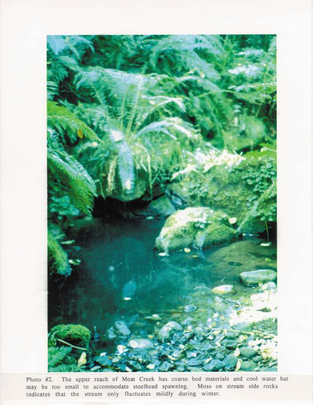
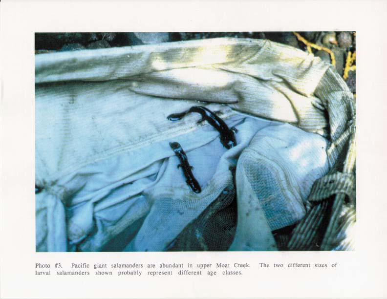
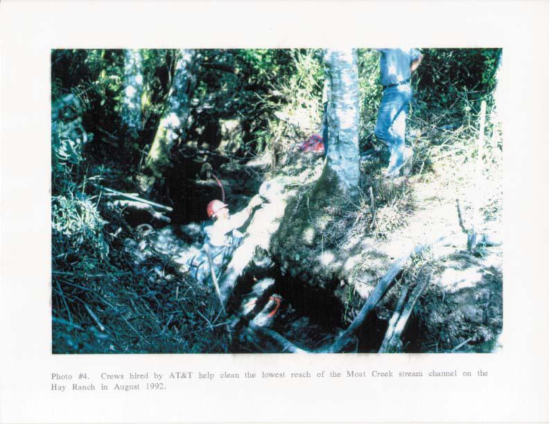
6 salmon or steelhead. The creek flowed in a clay bed with only a thin veneer of pea gravel in places. In the upper reach surveyed, above and below the 1992 spill site, the water temperature was 57 F. Moat Creek is incised in a narrow gorge in this reach and has approximately a 4% gradient. The stream bed is made up of predominantly course bed materials, including cobble and gravel (Photo #2). Very high densities of Pacific giant salamanders (Dicamptodon ensatus) were found during the survey. Three age classes seemed to be represented, with numerous two-inch long specimens, some four-inch long larvae and a few adults (8") that had retained gills and remained aquatic (Photo #3). Adult Pacific giant salamanders are usually terrestrial. Almost no trace of the spill was evident anywhere in the stream channel. No juvenile steelhead or rainbow trout were found in this upper reach despite a reported sighting just after the spill (Higgins, 1992). Discussions with Rick Macedo and Ed Ramos led to the conclusion that temporary CDFG personnel had made the report and had most likely mistaken a large Pacific giant salamander for a resident trout. A more extensive electrofishing survey of this stream reach in 1992 by Weldon Jones, a California Department of Fish and Game Biologist, also found no salmonids. The conclusion from the fisheries survey was that there are no salmon, steelhead or resident trout present in Moat Creek at this time nor is it likely that any were present at the time of the bentonite spill. Assessment of Recovery From Bentonite Spill Impacts Every reach of the stream channel surveyed seemed to have fully recovered from impacts of the August 1992 spill and following clean up efforts. Almost no trace of bentonite could be found in the vicinity of the spill site or anywhere in the channel below. One minor exception was that some non-native sandy materials were found on terraces next to log-jam removal sites. These materials were stored above the active channel and pose absolutely no threat to any aquatic resources. Stream clean up efforts, as shown in Photo #4, do not seem to have disturbed riparian root structure or otherwise caused any damage. All actions taken in Moat Creek by AT&T to limit damage from the spill seem to have been appropriate and to have prevented any long term damage to aquatic resources in the stream. Determining Stream Conditions Limiting Salmonid Production An extensive survey of Moat Creek was conducted on August 6, 1993 to try to determine limiting factors for salmon and steelhead production. Although another objective of this exercise was to assess restoration potential, decisions on that topic had to be deferred. 3
7 The fisheries survey conducted the day before had shown a total absence of salmonids in Moat Creek, yet many habitat parameters for salmon and steelhead seemed to be met. The entire stream had water temperatures suitable for salmonids, ranging from 53 F at the headwaters to 62 F in the lagoon. The cool temperatures are maintained because of a completely closed canopy over the stream along its entire course. The healthy riparian understory would also provide filter capacity to prevent fine sediment from entering the stream from any disturbance in upland areas. Under cut banks, woody plants growing along the stream margins and downed trees would provide cover for juvenile salmonids, were they present in Moat Creek. After walking a substantial portion of the stream, we came to the conclusion that lack of gravel in the stream bed would prevent spawning success in most reaches. All lower reaches of Moat Creek were either clay bottomed or had a thin layer of pea gravel overlying clay (Photo #). A small amount of cobble and gravel was found in terraces, above sites where log jams had been removed down stream of Curly Lane. The jams had formerly served to trap these course bed materials but also fine sediment. No appropriate site for salmon or steelhead spawning was available throughout the lowest 1.75 miles of the stream. Coho salmon are not able to access steeper reaches of small streams, so the lack of spawning substrate in low gradient reaches of Moat Creek near the ocean would make the stream unsuitable for them. The bed of Moat Creek in the upper reach is composed of bedrock, boulders, cobble and gravel, all of a uniform orange sandstone. The stream side rocks were covered with mosses to a level about four inches above summer base flow levels (Photo #2). The lack of scour on stream side rocks indicated that fluctuations in flow are moderate even during winter storms. It is likely that the healthy watershed conditions that prevail in upper Moat Creek moderate rapid peaks in stream flow even during intense rainfall. While it appears that substrate composition here might allow for salmonid production, the small size of the stream in this headwater area might preclude successful steelhead spawning. Native rainbow trout also occur frequently in coastal streams but are absent from in Moat Creek. One explanation for their absence could be that they may have been outcompeted by Pacific giant salamanders. During the August 6 field tour, it was noted that the stream appeared to be down cut in the reach below Curly Lane by somewhere between feet. Pea gravels in a linear pattern were embedded in stream banks a few feet above current stream flow which also suggested down cutting. Denuded banks at an old access for stock watering led to a hypothesis that grazing practices during times of early settlement might have triggered down-cutting. Several questions were raised regarding the stream bed condition of Moat Creek that required the opinion of an experienced geologist: 4
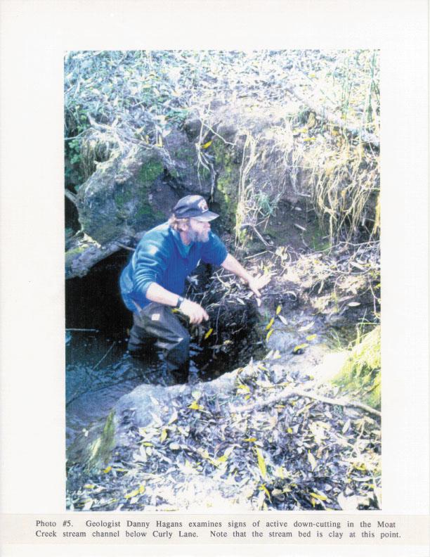
8 * What is responsible for lack of spawning gravels in the lower reaches of Moat Creek? * Is stream down-cutting a natural phenomenon or human induced? * Is down-cutting related to lack of salmonids? * Is there any cost-effective treatment that could be implemented to create spawning areas? Relationship of Watershed Geology to Salmonid Production On November 5, 1993, a geologic assessment of Moat Creek was conducted to aid in analysis of factors limiting salmonid production. An examination of a geologic map (Davenport, 1984) showed the watershed is completely lacking in any well consolidated bedrock materials (Figure 2). The parent material in the basin is almost exclusively weakly consolidated marine materials which weather rapidly. Also apparent in the geologic maps are numerous traces of faults within the Moat Creek watershed which probably have some bearing on stream down cutting. There are only four different rock formations that under-lie the Moat Creek basin: marine terrace deposits, the Galloway-Schooner Gulch formation, the German-Rancho formation and the Monterey group. The marine terrace deposits are composed of poorly to moderately consolidated marine silts, sands and quartz rich pea gravels and the Galloway-Schooner Gulch formation is moderately consolidated sandstone (Davenport, 1984). The German-Rancho formation has moderately hard, coarse grained sandstones interbedded with mudstone and less common conglomerate. While the Monterey group has some well consolidated, porcelaneous shale and siltstone, it also is composed of softer sandstone, siltstone and sandy mudstone (Davenport, 1984). Slates, shales, siltstones and mudstones are not only soft but often have bedding characteristics that causes the materials to erode in sheets. These plate-like clasts do not transform into rounded cobbles and gravels when weathered in a stream environment. The more well consolidated sandstones in the watershed do become rounded as they wash downstream but they usually have weak bedding planes which causes them to break down (Photo #5). This explains in part why coarse bed materials were present in headwaters of Moat Creek while lacking in lower reaches; the rocks simply disintegrate as they tumble downstream. The quartz-rich pea gravels of the marine terrace deposits are really the only truly hard rock in the basin; therefore, it is not surprising that they are often the only armoring seen in lower reaches of the stream. The 1906 Earthquake caused 11 feet of uplift at Manchester, just north of Point Arena. Danny Hagans said that Moat Creek is likely to have experienced similar uplift during major movements of the 5
9
10 San Andreas. It was his professional opinion that the down-cutting of the stream is happening in response to tectonic uplift and that Moat Creek might still be adjusting to changes caused by the 1906 quake. Since there is no hard rock under-lying the stream bed, there is no bedrock control to impede this adjustment. The principal limiting factor for salmon and steelhead in the Moat Creek basin, related to geology, is the lack competent bedrock and resulting lack of spawning substrate. The uplift rate has no direct bearing on presence or absence of salmonids since none could exist without spawning substrate. Alternative Course Offered For Fisheries Restoration There is no technically feasible or cost effective method to establish coho salmon or steelhead trout in Moat Creek. Because of the total lack of spawning substrate in the stream, gravels would have to be imported and weirs built in the stream to retain them. This exercise would be prohibitive in expense. The best restoration efforts are those where natural processes are restored so that benefits are self-sustaining. Any attempts to create fish habitat in Moat Creek would require constant maintenance and up keep. Even if spawning areas were established, other problems for productivity of fisheries might arise. Since most of the stream bottom is clay, invertebrate production might be restricted due to lack of surface area in the typical gravel matrix of a steelhead stream. Competition with other species would likely occur if salmonids were introduced, be harming the natural fauna of the stream. Since it is not logical to expend funds on fisheries habitat improvements on Moat Creek, alternative proximate watersheds were examined as potential restoration sites. Pt. Arena Creek, to the north, and Ross Creek, to the south, both have similar bedrock geology to Moat Creek; therefore, neither stream would be a good alternative. Schooner Gulch, just to the south of Moat Creek, has hard rock underlying its watershed, the Iverson basalt formation. This igneous rock is well consolidated and was formed by volcanic activity at mid-pacific spreading ridges then transported toward shore and uplifted by tectonic activity. Schooner Gulch seems to be the best choice for expenditure of restoration funds because it is known to have steelhead runs at present and opportunities for fisheries and watershed restoration are present in the basin with some land owners willing to cooperate in such efforts. Approximately one half mile of Schooner Gulch, above Schooner Gulch State Park, was surveyed on November 5 to assess fish habitat conditions. The stream bed was predominantly a mixture of cobble, gravel and bedrock. This particle size distribution would be suitable for salmonid spawning and rearing, although some fine sediment was present. The canopy of the stream 6
11 was completely closed and some downed large trees added to habitat complexity. The average gradient of the stream was approximately 3% and riffles and runs were much more frequent than pool habitats. The North Fork of Schooner Gulch converged with the main stem in the reach surveyed and appeared to have elevated levels of fine sediment, which could be indicative of erosion problems in that sub-basin. Schooner Gulch has a history of intensive timber harvest since World War II. Fisheries resources are thought to have declined substantially as a result of past flood damage after logging. More recent logging has been carried out in a more environmentally sensitive way but erosion risk may still be somewhat elevated. The logical progression for restoration in Schooner Gulch would be to implement erosion prevention measures to preclude stream damage in future floods and then to consider instream fisheries habitat improvement to increase pool frequency and depth. Another possible activity would be to restore the riparian canopy over Schooner Gulch if there are any areas where the stream lacks shade. President Clinton's Forest Ecosystem Management Plan (FEMAT, 1993) recognizes the need to stem the loss of additional salmon and steelhead habitat by preventing erosion in future floods. Throughout the Pacific Northwest, $185 million will be spent to remove segments of roads that could trigger landslides and to remove or replace under-sized culverts that could lead to failure of stream crossings during floods. Similar activities are needed in Schooner Gulch to prevent damage to salmonid habitat in future large storms. The FEMAT (1993) report also projects expenditure of $215 million to restore riparian zones, Pacific Northwest wide, to help improve ecosystem function of cold water streams. The need for riparian improvements in Schooner Gulch are unknown at this time. While steelhead have been seen spawning in Schooner Gulch in recent years, it is not known whether the stream is currently used by coho salmon. Coho salmon juveniles spend one year in freshwater and strongly prefer pools, especially those formed by large woody elements (Reeves et al., 1988). It is possible that past alterations in the stream channel, related to upland management and subsequent floods, may have decreased pool frequency and depth (NCRWQCB, 1993). Restoration activities in Schooner Gulch should consider the possibility of restoring coho salmon, if possible, because of the recognized risk of extinction of this species in the region (Higgins et al., 1992). Conclusion Moat Creek seems to have fully recovered from any detrimental impacts related to the bentonite spill in August, 1992 but it seems that the stream never harbored coho salmon or steelhead because of 7
12 natural geologic conditions. While it is infeasible to improve (or create) salmonid habitat in Moat Creek, the stream harbors a diverse and interesting population of amphibians which may make it of interest to local schools as field trip site for ecological studies. Schooner Gulch has the natural geologic conditions that provide spawning substrate for salmonids. It currently supports steelhead and but implementation of erosion control and prevention would help to guard against habitat loss in future large storm events. Further studies are needed to determine if coho salmon are present or have occurred historically in Schooner Gulch. Restoration activities could involve improving pool frequency and depth to help recovery of this species. Acknowledgements Assistance of Rick Macedo and Ed Ramos of the Californian Department of Fish and Game in electroshocking surveys is gratefully acknowledged. Special thanks are also offered to Craig Bell who helped in the fisheries survey. Brian Thurmond, President of the Moat Creek Management Agency, showed special interest in this project, participating in all field surveys to better understand resource conditions in Moat Creek. References Davenport, C.W Geology and Geomorphic Features Related to Landsliding, Point Arena 7.5' Quadrangle, Mendocino County, CA. Prepared for the California Department of Mines and Geology, Sacramento, CA. OFR SF. FEMAT, Forest Ecosystem Management: An Ecological, Economic, and Social Assessment. Draft Supplemental EIS for the USFS, USFWS, NOAA, USBLM, USEPA. Published by the USFS, Portland, OR p. Higgins, P Garcia River Drilling Mud Spill: Damage Assessment and Suggestions for Mitigation, Restoration and Monitoring. Prepared for Friends of the Garcia River. 21 p. Higgins, P., S. Dobush and D. Fuller, 1992, Factors in northern California threatening stocks with extinction. Prepared for the Humboldt Chapter American Fisheries Society, Arcata, CA. 26 p. McGinnis, S.M Freshwater fishes of California. University of California Press, Berkeley, CA. 316 p. 8
13 Northcoast Regional Water Quality Control Board Testing Indices of Cold Water Fish Habitat. Prepared for USEPA Assistance No. C and California SWRCB No NCRWQCB, Santa Rosa, CA. Reeves, G.H., F.H. Everest, and T.E. Nickelson, 1988, Identification of physical habitat limiting the production of coho salmon in western Oregon and Washington. USDA Forest Service, Pacific Northwest Research Station, Portland, Ore. PNW-GTR
14
15
16
17
18

19
San Lorenzo Valley Water District, Watershed Management Plan, Final Version Part I: Existing Conditions Report
 LIST OF FIGURES Figure 1-1. Map of the San Lorenzo River watershed Figure 2-1. The Santa Cruz Mountains Bioregion Figure 2-2. Protected areas within the San Lorenzo River watershed Figure 2-3. Primary
STREAM SURVEY File form No..
 scanned for KRIS THE RESOURCES AGENCY OF CALIFORNIA California Department of Fish and Game STREAM SURVEY File form No.. Date: September 4, 1969. NAME: North Fork Schooner Gulch Creek COUNTY: Mendocino.
Data Report : Russian River Basin Steelhead and Coho Salmon Monitoring Program Pilot Study
 Data Report 1999-1: Russian River Basin Steelhead and Coho Salmon Monitoring Program Pilot Study Sonoma County Water Agency 215 West College Avenue Santa Rosa, California 951 Prepared by David Cook Senior
Five Counties Salmonid Conservation Program - Fish Passage Design Workshop. February 2013
 Program - Aquatic Organisms and Stream Crossings Ecological Connectivity A watershed is a network of channels that drain a common boundary. Channel characteristics formed by interaction of precipitation,
PROJECT TO INSTALL LARGE WOOD HABITAT STRUCTURES IN THE CARMEL RIVER USING CALIFORNIA DEPARTMENT OF FISH AND GAME GRANT FUNDS
 PROJECT TO INSTALL LARGE WOOD HABITAT STRUCTURES IN THE CARMEL RIVER USING CALIFORNIA DEPARTMENT OF FISH AND GAME GRANT FUNDS The Monterey Peninsula Water Management District (MPWMD), in cooperation with
SECTION F FISH HABITAT CONDITION AND AQUATIC SPECIES DISTRIBUTION
 SECTION F FISH HABITAT CONDITION AND AQUATIC SPECIES DISTRIBUTION INTRODUCTION The fish species currently inhabiting the Gualala River WAU are steelhead trout (Oncorhynchus mykiss), sculpin (Cottus spp.),
Big Spring Creek Habitat Enhancement and Fishery Management Plans
 Big Spring Creek Habitat Enhancement and Fishery Management Plans November 5, 2012 Big Spring Events and Activities Center Newville, PA Charlie McGarrell Regional Habitat Biologist Pennsylvania Fish and
California Steelhead: Management, Monitoring and Recovery Efforts
 California Steelhead: Management, Monitoring and Recovery Efforts Jonathan Nelson Steelhead Management, Research and Restoration Program Oncorhynchus mykiss irideus California Steelhead - Hot Topics Implementation
FISH PASSAGE IMPROVEMENT in California s Watersheds. Assessments & Recommendations by the Fish Passage Forum
 FISH PASSAGE IMPROVEMENT in California s Watersheds Assessments & Recommendations by the Fish Passage Forum FISH PASSAGE IMPROVEMENT in California s Watersheds The mission of the Fish Passage Forum is
Abundance of Steelhead and Coho Salmon in the Lagunitas Creek Drainage, Marin County, California
 scanned for KRIS Abundance of Steelhead and Coho Salmon in the Lagunitas Creek Drainage, Marin County, California Prepared for: Marin Municipal Water District 220 Nellen Drive Corte Madera, California
FISHERIES BLUE MOUNTAINS ADAPTATION PARTNERSHIP
 FISHERIES A warming climate, by itself, substantially affects the hydrology of watersheds in the Blue Mountains. Among the key hydrologic changes projected under all scenarios for the 2040s and beyond
Minnesota Department of Natural Resources Division of Fish and Wildlife Section of Fisheries. Stream Survey Report. Luxemburg Creek.
 Minnesota F-29-R(P)-24 Area 315 Study 3 March 2016 Minnesota Department of Natural Resources Division of Fish and Wildlife Section of Fisheries Stream Survey Report Luxemburg Creek 2015 Mark Pelham Sauk
CHAPTER 4 DESIRED OUTCOMES: VISION, GOALS, AND OBJECTIVES
 CHAPTER 4 DESIRED OUTCOMES: VISION, GOALS, AND OBJECTIVES Vision One of the first steps in developing this Plan was articulating a vision - a clear statement of what the Plan strives to achieve and what
Juvenile Steelhead and Stream Habitat Conditions Steelhead and Coho Salmon Life History Prepared by: DW ALLEY & Associates, Fishery Consultant
 Juvenile Steelhead and Stream Habitat Conditions Steelhead and Coho Salmon Life History Prepared by: DW ALLEY & Associates, Fishery Consultant I-1. Steelhead and Coho Salmon Ecology Migration. Adult steelhead
California Steelhead: Management, Monitoring and Recovery Efforts
 California Steelhead: Management, Monitoring and Recovery Efforts Jonathan Nelson Steelhead Restoration & Management Program Oncorhynchus mykiss irideus California Steelhead Distinct Population Segments
Steelhead Society of BC. Thompson River Watershed Restoration and Enhancement Project #4 Nicola River Bank Stabilization and Enhancement Project
 Steelhead Society of BC Presents: Thompson River Watershed Restoration and Enhancement Project #4 Nicola River Bank Stabilization and Enhancement Project Application for Funding December 2013 1.0 BACKGROUND
Sub-watershed Summaries
 Project Description The Salmon Drift Creek Watershed Council (SDCWC) has focused their efforts in the Salmon River estuary for the past few years. The multifaceted partnership effort is nearing completion
Searsville Dam Removal
 Searsville Dam Removal A unique opportunity for all Presented by the Beyond Searsville Dam Coalition San Francisquito Creek flows into the San Francisco Bay near the Palo Alto Airport and Golf Course seen
Executive Summary. Map 1. The Santa Clara River watershed with topography.
 Santa Clara River Steelhead Trout: Assessment and Recovery Opportunities December 2005 Prepared By: Matt Stoecker and Elise Kelley, Ph.D. University of California, Santa Barbara Prepared For: The Santa
COA-F17-F-1343 YEAR END REPORT
 DAVE MARSHALL SALMON RESERVE RESTORATION, MAINTENANCE, AND UPGRADES YEAR END REPORT Prepared for: Fish and Wildlife Compensation Program Prepared by: Edith Tobe, RPBio, Executive Director Box 1791, Squamish,
Fish Habitat Restoration and Monitoring in Southeast Washington. Andy Hill Eco Logical Research, Inc.
 Fish Habitat Restoration and Monitoring in Southeast Washington Andy Hill Eco Logical Research, Inc. Fish Habitat Restoration and Monitoring in Southeast Washington Talk overview: Restoration projects
Study Update Tailrace Slough Use by Anadromous Salmonids
 Study Update Tailrace Slough Use by Anadromous Salmonids Goals and Objectives Identify what anadromous salmonids use the tailrace slough by: Life Stage (Juvenile, migrating and spawning adults) Timing
FINAL REPORT. Yonkers Creek Migration Barrier Removal Project Wonderstump Road Del Norte County. Submitted By:
 FINAL REPORT Yonkers Creek Migration Barrier Removal Project Wonderstump Road Del Norte County Submitted By: Del Norte County Community Development Department Yonkers Creek Migration Barrier Removal Project
Michigan Department of Natural Resources Status of the Fishery Resource Report Page 1
 Michigan Department of Natural Resources 2008-59 Status of the Fishery Resource Report Page 1 Bowens Manistee County, (T24N R16W Sec. 11, 12, 13, 14, 15, 24, and 30). Last surveyed 2008 Mark A. Tonello
5B. Management of invasive species in the Cosumnes and Mokelumne River Basins
 5B. Management of invasive species in the Cosumnes and Mokelumne River Basins Cosumnes River The Cosumnes River basin has a number of distinct habitat types that require different management strategies
PRE- PROPOSAL FORM - Lewis River Aquatic Fund
 PRE- PROPOSAL FORM - Lewis River Aquatic Fund 1. Applicant organization. USDA Forest Service Gifford Pinchot National Forest 2. Organization purpose Resource management agency 3. Project manager (name,
EcoLogic Memorandum. TO: Ben Brezell; EDR FROM: Mark Arrigo RE: Possible Impacts of Dredging Snooks Pond DATE: 6/4/07
 EcoLogic Memorandum TO: Ben Brezell; EDR FROM: Mark Arrigo RE: Possible Impacts of Dredging Snooks Pond DATE: 6/4/07 Background EDR P.C. (EDR) has been contracted by a landowner to assess the feasibility
Restoring the Kootenai: A Tribal Approach to Restoration of a Large River in Idaho
 Restoring the Kootenai: A Tribal Approach to Restoration of a Large River in Idaho Susan Ireland, Kootenai Tribe of Idaho Future of our Salmon Conference Technical Session August 2016 Healthy Floodplains,
Little Kern Golden Trout Status:
 Little Kern Golden Trout Status: The Little Kern Golden trout (LKGT) was proposed for federal listing as Threatened under the Endangered Species Act (ESA) on September 1, 1977 by the U. S. Fish and Wildlife
Olema Creek Watershed and
 Olema Creek Watershed and Cheda Creek Fish Surveys The objectives of this limited survey were several. First, we wanted to qualitatively assess changes in fish species composition and relative abundance
STEELHEAD SURVEYS IN OMAK CREEK
 STEELHEAD SURVEYS IN OMAK CREEK 2002 Annual Report Prepared by Chris Fisher John Arterburn Colville Confederated Tribes Fish and Wildlife Department P.O. Box 150 Nespelem, WA 99155 Prepared for Project
WFC 50 California s Wild Vertebrates Jan. 11, Inland Waters (Lakes and Streams) Lisa Thompson
 Lisa Thompson") Inland Waters: Lakes and Streams WFC 50 11 January 2011 Lisa Thompson Fisheries Extension Specialist Wildlife, Fish, & Conservation Biology Department University of California, Davis Take home messages
Inland Waters: Lakes and Streams WFC 50 11 January 2011 Lisa Thompson Fisheries Extension Specialist Wildlife, Fish, & Conservation Biology Department University of California, Davis Take home messages
Mid-Columbia Fisheries Enhancement Group Annual Report Fiscal Year 06: July 1, 2005 June 30, 2006
 Mid-Columbia Fisheries Enhancement Group Annual Report Fiscal Year 06: July 1, 2005 June 30, 2006 Mission Statement The mission of the Mid-Columbia Fisheries Enhancement Group is to restore self-sustaining
Tuolumne River Gravel Introduction
 Tuolumne River Gravel Introduction 2000 2003 Tuolumne River La Grange Gravel Addition, Phase II Course Sediment Replenishment Program Tuolumne River Salmonid Habitat Improvement Project River Mile 49.9
Final Bull Trout Genetics Monitoring Plan for the Wallowa Falls Hydroelectric Project. (FERC No. P-308) June 2017
 June 2017") Final for the Wallowa Falls Hydroelectric Project (FERC No. P-308) June 2017 Prepared by: Jeremiah Doyle PacifiCorp 825 NE Multnomah Street Portland, OR 97232 June, 2017 Page 1 of 8 Table of Contents 1.0
Final for the Wallowa Falls Hydroelectric Project (FERC No. P-308) June 2017 Prepared by: Jeremiah Doyle PacifiCorp 825 NE Multnomah Street Portland, OR 97232 June, 2017 Page 1 of 8 Table of Contents 1.0
Frequently Asked Questions About Revised Critical Habitat and Economic Analysis for the Endangered Arroyo Toad
 Q Frequently Asked Questions About Revised Critical Habitat and Economic Analysis for the Endangered Arroyo Toad Q. What is the arroyo toad? The arroyo toad (Bufo californicus) is a small, light greenish-grey
NEVADA DEPARTMENT OF WILDLIFE STATEWIDE FISHERIES MANAGEMENT
 NEVADA DEPARTMENT OF WILDLIFE STATEWIDE FISHERIES MANAGEMENT FEDERAL AID JOB PROGRESS REPORT F-20-50 2014 LAHONTAN CUTTHROAT TROUT STUDY WESTERN REGION NEVADA DEPARTMENT OF WILDLIFE, FISHERIES DIVISION
Salmon River Cooperative Noxious Weed Program (CNWP) Presented by the Salmon River Restoration Council
 Presented by the Salmon River Restoration Council") Salmon River Cooperative Noxious Weed Program (CNWP) Presented by the Salmon River Restoration Council Some of you may be thinking So where is Salmon River? Isn t it in Idaho, Washington, or Oregon? The
Salmon River Cooperative Noxious Weed Program (CNWP) Presented by the Salmon River Restoration Council Some of you may be thinking So where is Salmon River? Isn t it in Idaho, Washington, or Oregon? The
STREAM CLASSIFICATION AND MAPPING. Prepared For. MacMillan Bloedel Ltd. Menzies Bay Division BOX 6000, Campbell River V9W 5E1.
 STREAM CLASSIFICATION AND MAPPING OF STREAMS IN MENZIES AND OYSTER BAY Prepared For MacMillan Bloedel Ltd. Menzies Bay Division BOX 6000, Campbell River V9W 5E1 September 1998 a a North Island Biological
2012 Summary Report on the Juvenile Salmonid and Stream Habitat Monitoring Program
 2012 Summary Report on the Juvenile Salmonid and Stream Habitat Monitoring Program Prepared by: Kristen Kittleson, Fishery Resource Planner County of Santa Cruz Water Resources Program January 10, 2012
Chinook Salmon Spawning Study Russian River Fall 2005
 Chinook Salmon Spawning Study Russian River Fall 2005 Sonoma County Water Agency 2150 West College Avenue Santa Rosa, California 95401 Prepared by David Cook - Senior Environmental Specialist March 27,
1998 Willow Creek Downstream Migrant Trap Report. Draft. Prepared By: C. A. Walker. Lower Trinity Ranger District. Six Rivers National Forest
 1998 Willow Creek Downstream Migrant Trap Report Draft Prepared By: C. A. Walker Lower Trinity Ranger District Six Rivers National Forest September 1998 Executive Summary The downstream migrant trap was
Salmon and Steelhead in the American River Tim Horner, PhD Geology Department California State University, Sacramento
 Salmon and Steelhead in the American River Tim Horner, PhD Geology Department California State University, Sacramento What kind of fish are in the American River? The American River provides habitat for
Ecology of Place: What salmon need Eric Beamer Skagit River System Cooperative. November 2010
 Ecology of Place: What salmon need Eric Beamer Skagit River System Cooperative November 2010 Acknowledgements NOAA Fisheries NW Fisheries Science Center Tim Beechie George Pess Correigh Greene Talk overview
Don Pedro Project Relicensing
 Don Pedro Project Relicensing M ODESTO I RRIGATION D ISTRICT TURLOCK I RRIGATION D ISTRICT FERC PROJECT N O. 2299 Resident Fish in Don Pedro Reservoir Don Pedro Reservoir Fish Stocking (1971-Present) CDFG
3. The qualification raised by the ISRP is addressed in #2 above and in the work area submittal and review by the ISRP as addressed in #1.
 Please find attached a response from The Confederated Tribes of the Warm Springs Reservation of Oregon (CTWSRO) for Project # 2008-301-00, Habitat Restoration Planning, Design and Implementation within
TREND ANALYSIS FOR JUVENILE AND ADULT STEELHEAD
 5.5.1.4 TREND ANALYSIS FOR JUVENILE AND ADULT STEELHEAD In their Steelhead Restoration and Management Plan, the California Department of Fish and Game (CDFG) noted the precipitous decline of steelhead
Rehabilitation of Grimes Creek, a Stream Impacted in the Past by Bucket-lined Dredge Gold Mining, Boise River Drainage, July 2008 to August 2011.
 Rehabilitation of Grimes Creek, a Stream Impacted in the Past by Bucket-lined Dredge Gold Mining, Boise River Drainage, July 2008 to August 2011. Pam Harrington TU,1020 W. Main Street Suite 440, Boise,
COHO SALMON AND STEELHEAD TROUT OF JDSF. Peter Cafferata, Karen Walton and Weldon Jones 1
 COHO SALMON AND STEELHEAD TROUT OF JDSF Peter Cafferata, Karen Walton and Weldon Jones 1 Spawning and rearing habitat for anadromous fish is the dominant use of Jackson Demonstration State Forest's (JDSF)
Amendment to a Biological Assessment/Evaluation completed for the Coon Creek Land Disposal completed December Grand Valley Ranger District
 Amendment to a Biological Assessment/Evaluation completed for the Coon Creek Land Disposal completed December 2007 Grand Valley Ranger District Grand Mesa, Uncompahgre, Gunnison National Forests Prepared
Klamath Lake Bull Trout
 Klamath Lake Bull Trout Existing Populations The Klamath Lake Bull Trout SMU is comprised of seven existing populations and four populations classified as extinct or functionally extinct (Table 189). Populations
The Blue Heron Slough Conservation Bank
 1 The Blue Heron Slough Conservation Bank CONSERVATION BANKING July 19-23, 2010 CASE STUDY SERIES The Blue Heron Slough Conservation Bank (Washington) I. OVERVIEW & BACKGROUND: Location: Snohomish River
JUVENILE SALMONID POPULATION MONITORING REPORT LAGUNITAS CREEK MARIN COUNTY, CALIFORNIA FALL 1997
 JUVENILE SALMONID POPULATION MONITORING REPORT LAGUNITAS CREEK MARIN COUNTY, CALIFORNIA FALL 1997 Prepared By: Gregory M. Andrew, Fishery Biologist and Michael L. Cronin, Fishery Biologist Aide Marin Municipal
Shovelnose Creek Off-Channel Complex Berm Repair
 Shovelnose Creek Off-Channel Complex Berm Repair Recent high discharge events have put valuable off-channel salmonid rearing and spawning habitat at risk in the upper Squamish River. This document is a
Trout Unlimited Comments on the Scope of Environmental Impact Statement for the Constitution Pipeline Project, Docket No. PF12-9
 October 9, 2012 Kimberly D. Bose, Secretary Federal Energy Regulatory Commission 888 First Street, NE, Room 1A Washington, DC 20426 RE: Trout Unlimited Comments on the Scope of Environmental Impact Statement
WFC 10 Wildlife Ecology & Conservation Nov. 29, Restoration Ecology: Rivers & Streams. Lisa Thompson. UC Cooperative Extension
 Restoration Ecology: Rivers and Streams WFC 10 29 Nov 2010 Restoration of ecosystems often involves creating new systems with only partial resemblance to the original ecosystems Lisa Thompson Fisheries
Illinois Lake Management Association Conference March 23, 2018 By Trent Thomas Illinois Department of Natural Resources Division of Fisheries
 Illinois Lake Management Association Conference March 23, 2018 By Trent Thomas Illinois Department of Natural Resources Division of Fisheries Sources of Habitat Impairment Sedimentation Channelization
The Salmonid Species. The Salmonid Species. Definitions of Salmonid Clans. The Salmonid Species
 The Salmonid Species The Salmonid Species N. American salmon (2 more Asian species) Chinook ( King ) Coho ( Silver ) Sockeye Chum ( Dog ) Pink ( Humpy ) Sea-run trout Steelhead, Cutthroat, Dolly Varden
MCCAW REACH RESTORATION
 Final Report MCCAW REACH FISH RESTORATION PHASE B Jack McCaw Inland Empire Action Coalition http://www.wwccd.net/ Phone: 509-956-3777 Hours: 8:00-4:30 Walla Walla County Conservation District Snake River
The Calawah River System
 The Calawah River System The Calawah River is the largest tributary of the Bogachiel River and is formed by the confluence of the north and south forks of the Calawah. The two forks of the Calawah, CALAWAH
CHAPTER 1 - INTRODUCTION
 CHAPTER 1 - INTRODUCTION TABLE OF CONTENTS A. THE COQUILLE WATERSHED ACTION PLAN... 1-2 1. Scope of this Action Plan... 1-2 FIGURE 1-1 Coquille Watershed and Adjoining Areas: Major Rivers, Streams, and
Okanagan Sockeye Reintroduction
 Okanagan Sockeye Reintroduction Backgrounder Elders accounts, and other forms of Traditional Ecological Knowledge (TEK) tell us that many species of salmon once came into the Okanagan Valley and tell us
Summer Steelhead Surveys North Fork Trinity River Trinity County, California
 KRIS edition Summer Steelhead Surveys North Fork Trinity River Trinity County, California 1978-1997 By Loren Everest Fishery Biologist Weaverville Ranger District Shasta-Trinity National Forests October
Backgrounder and Frequently Asked Questions
 Backgrounder and Frequently Asked Questions Who Sent the Letter? The 60-day Notice of Intent to File Suit was sent by Conservation Angler, Wild Fish Conservancy, Snake River Waterkeeper, Friends of the
Redd Dewatering and Juvenile Salmonid Stranding in the Lower Feather River,
 Redd Dewatering and Juvenile Salmonid Stranding in the Lower Feather River, 2005-2006 Interim Report for NOAA Fisheries Prepared by: California Department of Water Resources Division of Environmental Services
Hydraulic Modeling of Stream Enhancement Methods
 Hydraulic Modeling of Stream Enhancement Methods Matthew J. Curry John J. Levitsky Abstract Development within watersheds increases the amounts of runoff causing stream erosion and degradation of stream
Burns Paiute Tribe Fisheries Department. Evaluate The Life History Of Native Salmonids Within The Malheur Subbasin Project #
 Burns Paiute Tribe Fisheries Department Evaluate The Life History Of Native Salmonids Within The Malheur Subbasin Project # 199701900 Prior to 1990 Technical and/or scientific background Malheur population,
Draft Central Valley Salmon and Steelhead Recovery Plan
 Draft Central Valley Salmon and Steelhead Recovery Plan for Sacramento River winter-run Chinook salmon Central Valley spring-run Chinook Salmon Central Valley Steelhead National Marine Fisheries Service
For next Thurs: Jackson et al Historical overfishing and the recent collapse of coastal ecosystems. Science 293:
 For next Thurs: Jackson et al. 2001. Historical overfishing and the recent collapse of coastal ecosystems. Science 293: 629-637. Resource: means of supplying a want or deficiency, from French resourdre
10 is bounded by wetlands between RM 1.8 and 3.1 on the south shore and more are scattered
 The Ozette System The Ozette watershed is made up of several lakes and large streams that combine to a total drainage area of 88.4 square miles. The most significant feature of the Ozette watershed is
Coho Salmon 1. COMMON NAMES: Silver salmon, Coho, blue back, silversides, and jack salmon.
 Coho Salmon 1 BACKGROUND 2 COMMON NAMES: Silver salmon, Coho, blue back, silversides, and jack salmon. DESCRIPTION: In the ocean the Coho is metallic blue on its back with silvery sides and white bellies.
NORTH RIVER FISH KILL PRELIMINARY REPORT 2014 SUMMARY
 NORTH RIVER FISH KILL PRELIMINARY REPORT 2014 SUMMARY A fish kill on Nor River was reported to e 1-800 Environmental emergency number on August 9, 2014. Representatives from e PEI Department of Environment,
Chadbourne Dam Repair and Fish Barrier
 Chadbourne Dam Repair and Fish Barrier Final Report for the Western Native Trout Initiative Prepared by: Carol Endicott Yellowstone Cutthroat Trout Conservation Biologist Montana Fish, Wildlife & Parks
REVISED DRAFT HABITAT SUITABILITY CURVES and COHO SALMON and STEELHEAD TROUT. Sawmill Creek Alaska
 REVISED DRAFT HABITAT SUITABILITY CURVES and COHO SALMON and STEELHEAD TROUT Sawmill Creek Alaska Blue Lake Hydroelectric Project, FERC No. 2230, Relicensing Prepared by: City and Borough of Sitka ( City
2 nd Steelhead Summit. October 27 & 28, 2016 in San Luis Obispo, CA
 + 2 nd Steelhead Summit October 27 & 28, 2016 in San Luis Obispo, CA 1 + Session Overview Sponsors: California Trout City of San Luis Obispo Sustainable Conservation California Conservation Corps Cachuma
UNIT 4E. SALMON SUPPLEMENTAL INFORMATION
 UNIT 4E. SALMON SUPPLEMENTAL INFORMATION In the STUDENT HANDOUTS/TEACHER PAGES Section of this unit, we have provided you with a host of information from various sources to supplement not only this unit,
Assessment of Elizabeth Lake as a Potential Candidate for Stocking
 Assessment of Elizabeth Lake as a Potential Candidate for Stocking Region 1, Nanaimo West Coast Planning Unit Ministry of Water, Land and Air Protection Prepared by: Laura Cassin Scott Silvestri 2002 1.0
State of San Francisco Bay 2011 Appendix O Steelhead Trout Production as an Indicator of Watershed Health
 State of San Francisco Bay 2011 Appendix O Steelhead Trout Production as an Indicator of Watershed Health Gordon Becker and Katherine Smetak, Center for Ecosystem Management and Restoration 290 Introduction
Freshwater Fish Assessment
 Alaska Department of Transportation & Public Facilities Seward Highway MP 7-9 6-7 Freshwater Fish Assessment March 14, 8 Prepared by HDR Alaska C Street, Suite 3 Anchorage, Alaska 993 Project Number: BR-BH-NH-OA3
Strategies for mitigating ecological effects of hatchery programs
 Strategies for mitigating ecological effects of hatchery programs Some case studies from the Pacific Northwest Kathryn Kostow Oregon Department of Fish and Wildlife Ecological risks occur when the presence
Southern Oregon Coastal Cutthroat Trout
 Species Management Unit Description Southern Oregon Coastal Cutthroat Trout The Southern Oregon Coastal Cutthroat Trout SMU includes all populations of cutthroat trout inhabiting ocean tributary streams
Aquatic Organism Passage at Road-Stream Crossings CHUCK KEEPORTS FOREST HYDROLOGIST ALLEGHENY NATIONAL FOREST WARREN, PENNSYLVANIA
 Aquatic Organism Passage at Road-Stream Crossings CHUCK KEEPORTS FOREST HYDROLOGIST ALLEGHENY NATIONAL FOREST WARREN, PENNSYLVANIA TOPICS COVERED Aquatic Organism Passage (AOP) Benefits of AOP Crossings
The Effects of Stream Adjacent Logging on Downstream Populations of Coastal Cutthroat Trout
 The Effects of Stream Adjacent Logging on Downstream Populations of Coastal Cutthroat Trout. D. S. Bateman 1, R.E. Gresswell 2, Aaron M. Berger 3, D.P. Hockman-Wert 4 and D.W. Leer 1 1 Department of Forest
Maryland Chapter Trout Unlimited Brook Trout Conservation Effort
 Maryland Chapter Trout Unlimited Brook Trout Conservation Effort Photo by Matt Kline Portfolio of Recent Work MDTU Brook Trout Conservation Coordinator: Scott C. Scarfone, ASLA sscarfone@oasisdesigngroup.com
Statement of Dr. Jack Williams Senior Scientist, Trout Unlimited. Before the
 Statement of Dr. Jack Williams Senior Scientist, Trout Unlimited Before the Subcommittee of Water and Power Energy and Natural Resources Committee United States Senate June 6, 2007 Mr. Chairman, Members
NEVADA DEPARTMENT OF WILDLIFE STATEWIDE FISHERIES MANAGEMENT FEDERAL AID JOB PROGRESS REPORTS F LAHONTAN CUTTHROAT TROUT EASTERN REGION
 NEVADA DEPARTMENT OF WILDLIFE STATEWIDE FISHERIES MANAGEMENT FEDERAL AID JOB PROGRESS REPORTS F-20-50 2014 LAHONTAN CUTTHROAT TROUT EASTERN REGION NEVADA DEPARTMENT OF WILDLIFE, FISHERIES DIVISION ANNUAL
Application of IP Models for Salmon and Steelhead Recovery Planning in California
 Application of IP Models for Salmon and Steelhead Recovery Planning in California Brian Spence and David Boughton NMFS Southwest Fisheries Science Center Uses of IP models in technical recovery planning
Minnesota Department of Natural Resources Division of Fish and Wildlife Section of Fisheries. Stream Survey Report. Three Mile Creek 2011
 Minnesota Department of Natural Resources Division of Fish and Wildlife Section of Fisheries Stream Survey Report Three Mile Creek 2011 By Joseph D. Stewig Montrose Area Fisheries Office TABLE OF CONTENTS
PRE- PROPOSAL FORM - 1. Applicant organization. USDA Forest Service Gifford Pinchot National Forest & WDFW Region 5
 PRE- PROPOSAL FORM - 1. Applicant organization. USDA Forest Service Gifford Pinchot National Forest & WDFW Region 5 2. Organization purpose USFS-Resource management agency WDFW-Fish and Wildlife management
Fish population survey report
 Fish population survey report Upper River Avon Catchment This report provides a summary of results from recent fish population surveys on the Tetbury Avon, Sherston Avon and River Marden The surveys were
EXTENT OF OBSERVATION
 scanned for KRIS THE RESOURCES AGENCY OF CALIFORNIA Department of Fish and Game STREAM SURVEY Date: May 25 and 31, 1977. NAME: Unnamed Stream (Tributary to Sonoma Creek) COUNTY: Sonoma. STREAM SECTION:
South Fork Chehalis Watershed Culvert Assessment
 South Fork Chehalis Watershed Culvert Assessment Water Resource Inventory Area 23 Lewis County Conservation District Final Report By: Kelly Verd and Nikki Wilson March 2003 Funded by: The Washington State
Minnesota Department of Natural Resources Division of Fish and Wildlife Section of Fisheries. Stream Survey Report. Cold Spring Creek.
 Minnesota F-29-R(P)-24 Area 315 Study 3 March 2015 Minnesota Department of Natural Resources Division of Fish and Wildlife Section of Fisheries Stream Survey Report Cold Spring Creek 2014 Mark Pelham Montrose
Blue Creek Chinook Outmigration Monitoring Technical Memorandum
 Blue Creek Chinook Outmigration Monitoring 2012 Technical Memorandum Prepared by: Andrew Antonetti and Erika Partee Yurok Tribe Fisheries Program PO Box 1027 Klamath, California 95548 In Partnership with:
Two types of physical and biological standards are used to judge the performance of the Wheeler North Reef 1) Absolute standards are measured against
 Absolute standards are measured against") 1 Two types of physical and biological standards are used to judge the performance of the Wheeler North Reef 1) Absolute standards are measured against fixed value at Wheeler North Reef only 2) Relative
1 Two types of physical and biological standards are used to judge the performance of the Wheeler North Reef 1) Absolute standards are measured against fixed value at Wheeler North Reef only 2) Relative
Oregon Spotted Frogs 101. Deanna Lynch U.S. Fish and Wildlife Service
 Oregon Spotted Frogs 101 Deanna Lynch U.S. Fish and Wildlife Service Oregon Spotted Frog Background Current Protected Status Federal - Proposed as threatened and proposed designation of critical habitat
NEVADA DEPARTMENT OF WILDLIFE STATEWIDE FISHERIES MANAGEMENT
 NEVADA DEPARTMENT OF WILDLIFE STATEWIDE FISHERIES MANAGEMENT FEDERAL AID JOB PROGRESS REPORTS F-20-52 2016 REDBAND TROUT EASTERN REGION NEVADA DEPARTMENT OF WILDLIFE, FISHERIES DIVISION ANNUAL JOB PROGRESS
P.O. Box 65 Hancock, Michigan USA fax
 This PDF file is a digital version of a chapter in the 2005 GWS Conference Proceedings. Please cite as follows: Harmon, David, ed. 2006. People, Places, and Parks: Proceedings of the 2005 George Wright
Know Your River - River Ogmore Salmon and Sea Trout Catchment Summary
 Know Your River - River Ogmore Salmon and Sea Trout Catchment Summary Introduction This report describes the status of the salmon and sea trout populations in the Ogmore catchments. Bringing together data
Know Your River Conwy Salmon & Sea Trout Catchment Summary
 Know Your River Conwy Salmon & Sea Trout Catchment Summary Introduction This report describes the status of the salmon and sea trout populations in the Conwy catchment. Bringing together data from rod