Kennebunk River Road-Stream Crossing Survey Prepared by: Wells National Estuarine Research Reserve 342 Laudholm Farm Road Wells, Maine 04090
|
|
|
- Emmeline Richards
- 5 years ago
- Views:
Transcription


1 Kennebunk River Road-Stream Crossing Survey 2010 Prepared by: Wells National Estuarine Research Reserve 342 Laudholm Farm Road Wells, Maine 04090
2
3 Acknowledgements The 2010 Kennebunk River Road-Stream Crossing Survey Report was produced by MCC Americorps member Ashley Pinkham, and Wells Reserve staff members Jacob Aman and Susan Bickford. We would like to give special thanks to Alex Abbott at the U.S Fish and Wildlife Service Gulf of Maine Coastal Program (GOMCP) for providing training, lending equipment, and providing vital assistance throughout the project. Many thanks also go out to the University of New England for loaning field equipment, and John Branscom at the Maine Turnpike Authority for providing access to sites on the Maine Turnpike. We would like to thank Michele Dionne, Ph.D, and Tin Smith of the Wells Reserve, John Burrows of the Atlantic Salmon Federation, and Landis Hudson of Maine Rivers for their continuous support of the survey. Finally we would like to thank our interns, Colby Chase, Marissa Hammond, Michael O Brien, Justin Williams, and Erin Lefkowitz for their hard work and dedication to this project. Cover Photographs Top: New culvert at the crossing of Lord s Brook and Route 111, in Lyman. Bottom Left: Tide gate at the outlet of the crossing of a tidal creek and Boothby Road in Kennebunk. Bottom Right: Outlet of culvert on a tributary of Duck Brook at the Limerick Road crossing in Arundel. I Page
4 Table of Contents Acknowledgements... I Table of Contents... II Summary Overview Survey Planning Data Summary Barrier Ranking Barrier Removal Priorities Next Steps and Conclusions References Appendices II Page
5 Summary This report discusses the results of the 2010 Road-Stream Crossing Survey conducted by the Wells National Estuarine Research Reserve. Staff and volunteers visited 83 roadstream crossings and evaluated numerous aspects of these structures for potential barriers to movement of fish and other aquatic organisms. Of these sites, 21 were determined to pose severe barriers to passage. 20 sites had perched outlets, 5 sites had perched inlets, 2 sites had inlets blocked 50% or more, and 1 site had an outlet blocked by a tide gate. Most of the structures surveyed were undersized, exhibiting large scour pools (25) and lack of substrate within the crossing (30), indicating increased velocity of water moving through the structure. The road-stream crossings that rank as severe barriers mostly occur in the upper reaches of the watershed and on the major tributaries. Road-stream crossings on the main stem of the river were all found to be adequate for fish passage. Overview The 2010 Kennebunk River Road-Stream Crossing Survey was conducted by the Wells National Estuarine Research Reserve (WNERR) in partnership with the U.S Fish and Wildlife Service Gulf of Maine Coastal Program (GOMCP), during the summer and fall of WNERR staff and volunteers spent 7 days in the field collecting data, and several weeks entering the information into a database and analyzing it. The results of this analysis are presented in this report. Background The U.S. Fish and Wildlife Service Gulf of Maine Coastal Program (GOMCP) is compiling a statewide database of road-stream crossing that have been surveyed by state and federal agencies to determine whether or not they block upstream or downstream movement of fish and aquatic organisms. Surveys have been conducted in the Penobscot River, Sheepscot River, Saco River, and others. The 2010 Kennebunk Road-Stream Crossing Survey is a part of this greater statewide effort. The survey is also a component of efforts to restore diadromous fish to the Kennebunk and Mousam River watersheds in York County, Maine. Road crossings are as diverse as the parts of the stream that they intersect, and come in many shapes and sizes. Surveys of crossings in other Maine river systems have shown that the majority of crossings tend to pose a barrier to movement of fish (Abbott, 2008; Abbott, 2009). Identification and removal of stream barriers is essential for successful restoration of diadromous fish, and for improving habitat connectivity for resident fish and aquatic organisms. Data collected from the crossing survey is used to identify priority restoration sites and provide important cost benefit analysis for any proposed restoration. In order to maximize the usefulness of the crossing survey, additional studies must also be conducted regarding the location and quality of fish habitat. Barrier removal efforts should be coordinated with Page
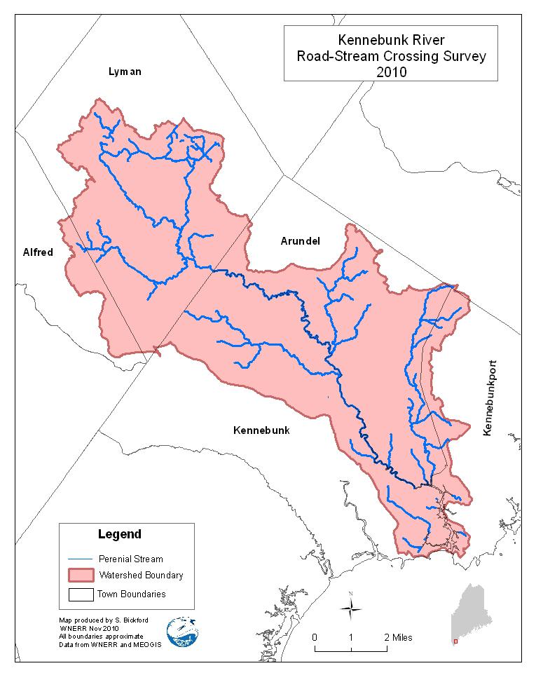
6 road improvement efforts by the towns, State of Maine, and the Maine Turnpike Authority, as well as private landowners. In the summer of 2009, John Burrows and Landis Hudson approached the Wells NERR about conducting a stream barrier survey in the Kennebunk River and Mousam River watersheds, using the GOMCP protocol developed by Alex Abbott. In November the Wells NERR hosted a training on how to plan and implement a survey of road-stream crossings, presented by Alex. Wells Reserve staff and volunteers with the Mousam and Kennebunk Rivers Alliance attended a morning session on planning and conducting a survey with photo examples of crossing types that would be encountered in the field, followed by an afternoon field exercise in survey techniques and data collection. Several sites within the Mousam and Merriland Rivers were surveyed. Over the course of the winter the Wells NERR developed plans to survey the Kennebunk River watershed road-stream crossings, and to incorporate the survey into a University of New England, summer semester 2010 GIS course, instructed by GIS specialist Sue Bickford. As summer began, enrollment in the course was too low, and the course was canceled. The Wells NERR determined that the survey was still possible and would be carried out by staff and interns from the research and stewardship departments. Two further trainings were then planned. The first was held in early June as a refresher for staff members who would be leading individual teams. The second training was held a few weeks before the survey was scheduled to begin, in order to train the interns and summer volunteers on survey techniques. Project Area From its headwaters at Kennebunk Pond to its mouth between Kennebunk and Kennebunkport, the Kennebunk River is approximately 15 miles in length and runs through the towns of Lyman, Arundel, Kennebunk, and Kennebunkport. Major ponds within the Kennebunk River watershed include Kennebunk Pond located in Lyman, Alewife Pond located in Kennebunk, Davis and Brimstone Pond in Arundel. The watershed drains 38 square miles and includes larger tributary streams of Carlisle Brook, Lords Brook, and Ward Brook, and smaller tributary streams such as Duck Brook, East Outlet, Arundel Swamp Brook, Springy Brook, Sunken Brook, and Wonder Brook. The landscape surrounding the upper reaches of the river, which lies west of Interstate 95, remains mostly rural and undeveloped. Development increases as the river approaches the coast. The river reaches head of tide downstream of the Route 1 Bridge where it transitions from freshwater to brackish saltwater and finally meets the Gulf of Maine in Kennebunkport. There are two active land trusts within the watershed. The Kennebunk Land Trust owns three preserves on the Kennebunk River: Alewife Woods, a 626 acre parcel that includes Alewife Pond; the 27 acre Wonder Brook Preserve; and the 14 acre Butler Preserve. The Kennebunkport Conservation Trust owns the Town Forest Preserve which lies in the northeastern section of the watershed. In 2001 the Kennebunk River was placed on the Page
7 Maine Department of Environmental Protection's Nonpoint Source Priority Watershed List. Habitat Connectivity To complete their life cycles, fish and other aquatic organisms must have access to all habitats needed for basic life functions during each stage of development, growth, and reproduction. Fish require access to spawning and nursery habitat, and must move throughout river systems to locate food and escape harmful environmental conditions including low water levels, low oxygen levels, and high water temperature. Culverts which are undersized, blocked, or perched prohibit resident and migratory fish species, aquatic insects, amphibians, and other animals from accessing essential habitat needed to survive, and can adversely alter nearby stream conditions. Survey Planning The Kennebunk River watershed was selected to be surveyed because of ongoing fisheries restoration work by the Wells Reserve, Maine Rivers, and the Mousam and Kennebunk Rivers Alliance in the Kennebunk River. These groups hope to conduct a survey of road-stream crossings in the Mousam River watershed as well, but thought that the Kennebunk River would be best to start with due to its smaller size and the proximity of the majority of crossings to the Wells NERR. GIS Data Road-stream crossings were identified using stream and road data obtained from the Maine Office of GIS. The watershed was divided into 5 sections and enlarged maps of each section were created to help the survey teams locate crossings in the field. A site index was then created which included unique site identification numbers, GPS coordinates, road name, stream name, and map section number. Crossings at railroads, trails, and private roads were not mapped for this survey. Survey Protocol The Maine Road-Stream Crossing Survey Manual (Abbott 2009) was used as a survey guide and protocol. This document outlines culvert types and stream conditions that may be encountered in the field, methods for data collection, data sheets and diagrams, equipment needed, and provides survey planning guidance. We created a quick reference guide which provides tips for taking difficult measurements out in the field. Several sections of the datasheet were highlighted to aid assessment of specific structure types, tailwater scour pool depth, inlet and outlet terms of importance, and upstream/downstream substrate. We also created a guide to explain how to correctly read the pocket rod and stadium rod, and how to record and save GPS data points. See Appendix A Page
8 Safety in the field is very important. We created a checklist of survey and safety equipment to be used at the beginning and end of each survey day, including a first aid kit, orange traffic cones, and OSHA approved safety vests. Survey kits with equipment and guides were assembled in backpacks for each survey team. Teams were also provided with a cell phone contact list, a DeLorme map, a site index with GPS locations, site ID numbers for use at unplanned sites, extra batteries and, pencils. Road-Stream Crossing Database Data collected from the field was entered into an ERSI Personal Geodatabase (a spatially aware Microsoft Access Database) developed by GOMCP, to aid with future analysis. To assist with data entry using the database a Road-Stream Crossing Database Guide was created. See Appendix B. Data Summary Road-Stream crossing sites were identified using road and stream data obtained from the Maine Office of GIS during survey planning. Additional sites were identified and surveyed in the field. Table 1 shows the number of planned survey sites mapped prior to the survey, the total number of unsurveyed sites, and additional surveyed sites that were not identified with GIS. Sites that were not surveyed include 1) bridges adequate for fish passage 2) posted, inaccessible, or nonexistent sites (those that were identified with GIS but were found to be nonexistent in the field) 3) structures that had a span of less than 18 inches. TABLE 1. PLANNED, UNSURVEYED AND ADDITIONAL SITES # of Sites % of Sites Planned Sites 76 92% Additional Sites 7 8% Total Sites % Surveyed 58 70% Unsurveyed Sites: 25 30% Bridge Adequate for Passage 11 Inaccessible 3 Site Does Not Exist 4 Total Span < 18 Inches 6 Dam Page
9 Of the 58 sites surveyed, 42 (72%) exhibited more than one factor that would limit passage of fish and other aquatic organism. We found that 20 (35%) sites had perched outlets, inhibiting upstream movement of fish and aquatic organisms. A smaller number of sites (9%) had perched inlets, limiting both upstream and downstream movement. More than half (53%) of sites lacked substrate within the crossing, and 25 (44%) included a large tailwater scour pool. Lack of substrate and scour pools are indicators of increased stream velocity as it passes through an undersized crossing structure. High velocity water can pose a barrier to fish and aquatic organism movement (Eberhardt et al. 2010). TABLE 2. SURVEYED SITE CONDITIONS SUMMARY # Sites % of Sites Multiple Culverts 13 23% Paved Site 46 81% Unpaved Site 11 19% Public Road 56 98% Private Road 1 2% Trail 1 2% Blocked Inlets 4 7% Severely Blocked Inlets (>50% Blocked) 2 4% Inlet Drop 8 14% Perched Inlet 5 9% Deformed Inlet 3 5% Perched Outlet 20 35% No Substrate In Culverts 30 53% Large Tailwater Scour Pool 25 44% Page
10 FIGURE 1. ROAD-STREAM CROSSING AND DISTRIBUTION Page
11 Barrier Ranking In order to prioritize sites for restoration they were given one of three rankings: severe, moderate, or not a barrier. To be categorized as a severe barrier a site must have an inlet that is perched or is blocked 50% or more, or have a perched outlet. Severe barriers usually present multiple limiting factors for passage of aquatic organisms. Factors include a perched outlet or inlet, and indicators of increased stream velocity such as a tailwater scour pool or lack of substrate within the crossing structure. This ranking is meant to identify crossings with the most serious and fundamental structural deficiencies related to aquatic organism passage; it is not focused on one species, but does consider fish passage first, and other aquatic organisms second (Abbott 2009). Sites that did not include one of the three severe barrier ranking criteria, but did include indicators of high velocity, were ranked as moderate barriers. If a site demonstrated no sign of blockage and lacked any of these criteria, it was ranked as not a barrier. TABLE 4 BARRIER RANKING # of Sites % of Sites *Severe Barriers: 21 36% Blocked Inlet (Blocked 50% or More) 2 3% Perched Inlet 5 9% Perched Outlet 20 34% Tide Gate 1 2% Moderate Barriers 22 38% Not A Barrier 14 24% Total Surveyed Sites % * Some crossings included more than one factor that would result in a severe ranking Page
12 FIGURE 2 SEVERE BARRIER DISTRIBUTION Page

13 Barrier Removal Priorities Initial analysis of survey data indicates that most of the severe barriers at road-stream crossings are located above known dams in the upper reaches of the watershed around Kennebunk Pond. Any meaningful restoration efforts at these crossings must therefore include establishment of fish ladders or other fish passage structures, or removal of the dam. The cost of barrier removal must also be considered when prioritizing sites for remediation. High priority removal sites will be those which can open access to the most habitat per dollar spent. While approximately one third of the habitat in the Kennebunk River system is located above the first dam on the main stem, three major tributaries join the river below that point. This is important because this dam is the most significant barrier in the system in terms of the cost required to establish passage. Ward Brook drains Alewife Pond in Kennebunk and does not pass through any severe or moderate barriers at Block outlet at Goff Mill Brook crossing on Sinnott Road in Arundel. road crossings. There are no man made dams on Ward Brook, though beaver are active in this stream and any present beaver dams could obstruct fish passage. Goff s Mill Brook drains the southeastern portion of the watershed in Arundel and Kennebunkport. A small dam is located just upstream of River Road, before the brook converges with the Kennebunk River. There are two severe barriers on the brook. At the crossing on Sinnott Road a large amount of rip rap blocks the outlet of a pipe arch culvert. Upstream at Whispering Fern Way, the outlet of the box culvert is perched during low water periods. In addition three severe barriers exist at crossings on small tributaries of the brook. Duck Brook drains Davis Pond in Arundel and passes through one severe barrier at the crossing on Limerick Road. This site has perched outlet as well as a partial blockage just upstream, where a structure, possibly an old dam, has been breached. Three severe barriers exist at crossings on small tributaries of the brook as well Page

14 Perched Outlet at Duck Brook crossing on Limerick Road in Arundel. Next Steps and Conclusions The road-stream crossings evaluated in this survey represent the majority of potential barriers to fish passage in the Kennebunk River watershed. There are also at least 5 dams throughout the drainage, as well as falls and other natural barriers that will need to be evaluated, including several crossings at trails, railroads, private roads, and land trust properties. An assessment of habitat above and below severe road-stream crossings is planned for 2011 and will allow for further prioritization of restoration efforts. Work still needs to be done to compile a complete inventory of all barriers to fish and aquatic organisms in the Kennebunk River watershed. A dam and natural barrier survey along with a survey of railroad crossings, trails, and private driveways must also be carried out to evaluate habitat connectivity in the watershed. This data can then be combined with habitat surveys to help prioritize restoration efforts. Data from this survey indicates that many of the severe barriers are located in headwater streams, and a majority of habitat downstream of the headwaters is connected. The largest portion of the watershed with good to moderate connectivity includes the main stem from the mouth to the Days Mill Dam, Ward Brook, and Alewife Pond. Immediately above Days Mill Dam is another smaller network of well- to moderately well-connected stream habitat which includes portions of Carlisle Brook, Lord s Brook, and Sunken Brook which is the outlet of Kennebunk Pond. A small dam on Sunken Brook is the only major barrier between Kennebunk Pond and the Days Mill Dam. Establishment of fish passage at these two dams would connect Kennebunk Pond to the Gulf of Maine and should be a priority for any long term efforts to restore sea-run fish to the Kennebunk River. Improvement of habitat connectivity throughout the Kennebunk River Watershed will require collaboration between the state, towns, private land owners, conservation organizations, and community partners in to be successful. Engagement of these groups should be a major component of future restoration efforts Page

15 Bridge over Ward Brook on Alewife Road in Kennebunk. References Abbott, Alex; 2008 Middle-Penobscot River Stream Barrier Surveys; Maine Forest Service; 25 March 2009; Abbott, Alex; 2007 Lower-Penobscot River Stream Barrier Surveys; Maine Forest Service; 5 March 2008; Abbott, Alex; Maine Road-Stream Crossing Survey Manual; U.S. Fish and Wildlife Service Gulf of Maine Coastal Program; May 2008; Eberhardt, A. L., D. M. Burdick, M. Dionne The Effects of Road Culverts on Nekton in New England Salt Marshes: Implications for Tidal Restoration. Restoration Ecology Appendices Appendix A: Quick Reference Guide Appendix B: Database Entry Guide Page
FISH PASSAGE IMPROVEMENT in California s Watersheds. Assessments & Recommendations by the Fish Passage Forum
 FISH PASSAGE IMPROVEMENT in California s Watersheds Assessments & Recommendations by the Fish Passage Forum FISH PASSAGE IMPROVEMENT in California s Watersheds The mission of the Fish Passage Forum is
COLUMBIA LAKE DAM REMOVAL PROJECT
 COLUMBIA LAKE DAM REMOVAL PROJECT Major Goals of the Columbia Lake Dam Removal: Reconnect 10 miles of the Paulins Kill River to the Delaware River, restoring natural flow regime and sediment transport.
Columbia Lake Dam Removal Project
 Columbia Lake Dam Removal Project Major Goals of the Columbia Lake Dam Removal: Reconnect 10 miles of the Paulins Kill River to the Delaware River, restoring natural flow regime and sediment transport.
Newaukum Watershed Culvert Assessment
 Newaukum Watershed Culvert Assessment Water Resource Inventory Area 23 Lewis County Conservation District Final Report By: Kelly Verd and Nikki Wilson July 2002 Funded by: Chehalis Fisheries Restoration
Five Counties Salmonid Conservation Program - Fish Passage Design Workshop. February 2013
 Program - Aquatic Organisms and Stream Crossings Ecological Connectivity A watershed is a network of channels that drain a common boundary. Channel characteristics formed by interaction of precipitation,
Overview Open Space and Recreation
 Overview Open Space and Recreation Open Space Plan (2004) Environmental Priority Areas Town Character Priority Areas Recreational Facilities maintained by the Town RSU 21 Recreational Facilities in Kennebunk
Interim Guidance Fish Presence Absence
 Interim Guidance Fish Presence Absence Source: Forest Practices Act Guidance for Division 635 of the forest practices act dealing with stream classification when no fish surveys have been done (referenced
Assessing Ecosystem Impacts from Road Stream Crossings through Community Involvement
 Assessing Ecosystem Impacts from Road Stream Crossings through Community Involvement Background Why is the NH Fish and Game Department interested in culverts? Block fish migration Reduce opportunities
Endangered Species Act and FERC Hydroelectric Projects. Jeff Murphy & Julie Crocker NHA New England Meeting November 16, 2010
 Endangered Species Act and FERC Hydroelectric Projects Jeff Murphy & Julie Crocker NHA New England Meeting November 16, 2010 Shortnose Sturgeon Federally listed as endangered in 1967 Listed under the sole
Resources and Guidance for writing a River Herring Management Plan
 Resources and Guidance for writing a River Herring Management Plan In 2011 members of the River Herring Network brainstormed a list of questions that should be answered in order to develop a plan for herring
Aquatic Organism Passage at Road-Stream Crossings CHUCK KEEPORTS FOREST HYDROLOGIST ALLEGHENY NATIONAL FOREST WARREN, PENNSYLVANIA
 Aquatic Organism Passage at Road-Stream Crossings CHUCK KEEPORTS FOREST HYDROLOGIST ALLEGHENY NATIONAL FOREST WARREN, PENNSYLVANIA TOPICS COVERED Aquatic Organism Passage (AOP) Benefits of AOP Crossings
Columbia Lake Dam Removal Project
 Columbia Lake Dam Removal Project The Columbia Lake dam located 1/4 mile upstream of the Paulins Kill River's confluence with the Delaware River in Knowlton Township, Warren County has been proposed for
Little Traverse Bay Watershed Road/Stream Crossing Inventory
 Little Traverse Bay Watershed Road/Stream Crossing Inventory Completed by Tip of the Mitt Watershed Council with support from: Petoskey-Harbor Springs Area Community Foundation s Little Traverse Bay Protection
Conserving the Forests, Lakes and Streams of Northeast Michigan
 4241 Old US 27 South, Suite 2, Gaylord, Michigan 49735 (989) 448-2293 www.huronpines.org info@huronpines.org Prioritized Restoration Projects in the AuSable River Watershed Summer 2015 Update from Huron
A BLUEPRINT FOR THE PENOBSCOT RIVER WATERSHED
 A BLUEPRINT FOR THE PENOBSCOT RIVER WATERSHED About this series 2 # for a healthy Penobscot watershed M aine rivers used to be full of fish swimming upstream from the ocean every year on their spawning
Washington State Fish Passage Barrier Removal Projects. Casey Kramer, PE WSDOT State Hydraulics Engineer
 Washington State Fish Passage Barrier Removal Projects Casey Kramer, PE WSDOT State Hydraulics Engineer 2014 National Hydraulic Engineering Conference Iowa City, IA August 20 th, 2014 WSDOT Fish Passage
FISH PASSAGE ON THE BRONX RIVER: A VISION OF THE BRONX RIVER ECOLOGICAL AND RESTORATION MANAGEMENT PLAN
 FISH PASSAGE ON THE BRONX RIVER: A VISION OF THE BRONX RIVER ECOLOGICAL AND RESTORATION MANAGEMENT PLAN THE SNUFF MILL DAM, BRONX ZOO DAM & 182 ND STREET DAM NEW YORK BOTANICAL GARDEN & BRONX ZOO BRONX
Rhode Island Department of Environmental Management Division of Fish and Wildlife American Shad Habitat Plan for the Pawcatuck River
 Rhode Island Department of Environmental Management Division of Fish and Wildlife American Shad Habitat Plan for the Pawcatuck River Prepared by: Phil Edwards, Rhode Island Department of Environmental
Merrimack River Watershed MERRIMACK RIVER WATERSHED
 MERRIMACK RIVER WATERSHED 96 Merrimack River Watershed Merrimack River Newburyport, Amesbury, Merrimack, Haverhill, Groveland, Methuen, Lawrence, N. Andover, Andover, Dracut, Tewksbury, Lowell, Chelmsford,
Three point plan to addressing land use and habitat loss impacts on Chesapeake Bay tidal fish and shellfish
 Three point plan to addressing land use and habitat loss impacts on Chesapeake Bay tidal fish and shellfish 1. Establish Principles for Protection of Chesapeake Bay Fish and Shellfish The Fisheries GIT
ADOPT-A-STREAM WATERSHED APPROACH COMMUNITY-BASED STEWARDSHIP. Nova Scotia Salmon Association March 2005
 ADOPT-A-STREAM A WATERSHED APPROACH TO COMMUNITY-BASED STEWARDSHIP Nova Scotia Salmon Association March 2005 This manual is a revised and updated version of the 1994 Adopt-a-Stream manual that was prepared
Follow this and additional works at:
 University of Massachusetts - Amherst ScholarWorks@UMass Amherst International Conference on Engineering and Ecohydrology for Fish Passage International Conference on Engineering and Ecohydrology for Fish
RIVER HERRING PROGRAM
 RIVER HERRING PROGRAM River Herring NORTHEAST REGION Assessing Sustainability of River Herring Runs Department of Marine Resources Award Amount... $400,483 Grantee Match... $415,340 Total Project... $815,823
OVERVIEW OF MID-COLUMBIA FISHERIES ENHANCEMENT GROUP
 Mid-Columbia Fisheries Enhancement Group MISSION STATEMENT The Mid-Columbia Fisheries Enhancement Group is a non-profit organization dedicated to restoring selfsustaining salmon and steelhead populations
Sub-watershed Summaries
 Project Description The Salmon Drift Creek Watershed Council (SDCWC) has focused their efforts in the Salmon River estuary for the past few years. The multifaceted partnership effort is nearing completion
ADDENDA B Hydrologic and Hydraulic (H&H) Study Guidance 2019
 Study Guidance 2019") 09/25/2018 DRAFT FEMA Region I PA H&H Study ADDENDA B Hydrologic and Hydraulic (H&H) Study Guidance 2019 Region I Federal Emergency Management Agency (FEMA) Public Assistance Hydrologic and Hydraulic (H&H)
09/25/2018 DRAFT FEMA Region I PA H&H Study ADDENDA B Hydrologic and Hydraulic (H&H) Study Guidance 2019 Region I Federal Emergency Management Agency (FEMA) Public Assistance Hydrologic and Hydraulic (H&H)
South Fork Chehalis Watershed Culvert Assessment
 South Fork Chehalis Watershed Culvert Assessment Water Resource Inventory Area 23 Lewis County Conservation District Final Report By: Kelly Verd and Nikki Wilson March 2003 Funded by: The Washington State
Project Report for Marsh Creek and Albion River Instream Fish Barrier Removal Flynn Creek Road, CR 135, M.P. 8.1 and 8.3
 Project Report for Marsh Creek and Albion River Instream Fish Barrier Removal Flynn Creek Road, CR 135, M.P. 8.1 and 8.3 Project Title: Marsh Creek and Albion River Instream Fish Barrier Removal, Flynn
6TH PELLETIER BROOK LAKE T15 R9, Aroostook Co. U.S.G.S. Gardner Pond, Maine (7 1/2 )
") 6TH PELLETIER BROOK LAKE T15 R9, Aroostook Co. U.S.G.S. Gardner Pond, Maine (7 1/2 ) Fishes Brook trout Minnows Blacknose dace Pearl dace Physical Characteristics Area - 27 acres Average depth - 2 feet
6TH PELLETIER BROOK LAKE T15 R9, Aroostook Co. U.S.G.S. Gardner Pond, Maine (7 1/2 ) Fishes Brook trout Minnows Blacknose dace Pearl dace Physical Characteristics Area - 27 acres Average depth - 2 feet
Chagrin River TMDL Appendices. Appendix F
 Appendix F The following are excerpts from the Eastern Brook Trout Joint Venture s Conservation Strategy (Working Draft v.6), Conserving the Eastern Brook Trout: Strategies for Action Found at: http://www.easternbrooktrout.org/constrategy.html
Feasibility and Planning Study
 Feasibility and Planning Study Inland Bays Migratory Fish Passage Restoration Feasibility and Planning Study By Roy W. Miller Policy Coordinator A presentation about options and obstacles for allowing
Lamprey Rivers Advisory Committee (LRAC) Annual Report FY 2017 (Oct. 1, 2016 Sept. 30, 2017)
 Annual Report FY 2017 (Oct. 1, 2016 Sept. 30, 2017)") Lamprey Rivers Advisory Committee (LRAC) Annual Report FY 2017 (Oct. 1, 2016 Sept. 30, 2017) Participants on the Lamprey River Eco-paddle Photo courtesy of Peter Sawtell We are pleased to feature an outreach
Lamprey Rivers Advisory Committee (LRAC) Annual Report FY 2017 (Oct. 1, 2016 Sept. 30, 2017) Participants on the Lamprey River Eco-paddle Photo courtesy of Peter Sawtell We are pleased to feature an outreach
Michigan Department of Natural Resources Status of the Fishery Resource Report Page 1
 Michigan Department of Natural Resources 2008-59 Status of the Fishery Resource Report Page 1 Bowens Manistee County, (T24N R16W Sec. 11, 12, 13, 14, 15, 24, and 30). Last surveyed 2008 Mark A. Tonello
Black Sturgeon Regional Plan
 Black Sturgeon Regional Plan This is one of twenty Regional Plans that support implementation of the Lake Superior Biodiversity Conservation Strategy (Strategy). The Strategy, prepared and overseen by
Great Lakes Stream Crossing Inventory Instructions
 Great Lakes Stream Crossing Inventory Instructions This document is a guide to completing the Stream Crossing Data Sheet (2/28/11 version). Careful attention to this guidance will ensure consistent crossing
Executive Summary. Map 1. The Santa Clara River watershed with topography.
 Santa Clara River Steelhead Trout: Assessment and Recovery Opportunities December 2005 Prepared By: Matt Stoecker and Elise Kelley, Ph.D. University of California, Santa Barbara Prepared For: The Santa
Restoring the Kootenai: A Tribal Approach to Restoration of a Large River in Idaho
 Restoring the Kootenai: A Tribal Approach to Restoration of a Large River in Idaho Susan Ireland, Kootenai Tribe of Idaho Future of our Salmon Conference Technical Session August 2016 Healthy Floodplains,
The Life History and Management of Alewife (Alosa pseudoharengus)
") The Life History and Management of Alewife (Alosa pseudoharengus) Abigail Franklin, University of Massachusetts, Amherst Department of Natural Resources Conservation The Biology and Management of Alewife
The Life History and Management of Alewife (Alosa pseudoharengus) Abigail Franklin, University of Massachusetts, Amherst Department of Natural Resources Conservation The Biology and Management of Alewife
Minnesota Department of Natural Resources Division of Fish and Wildlife Section of Fisheries. Stream Survey Report. Luxemburg Creek.
 Minnesota F-29-R(P)-24 Area 315 Study 3 March 2016 Minnesota Department of Natural Resources Division of Fish and Wildlife Section of Fisheries Stream Survey Report Luxemburg Creek 2015 Mark Pelham Sauk
Kasaan to Goose Creek Road Project Project Description U.S. Army Corps of Engineers Permit The following table presents the mile point of the culverte
 Kasaan to Goose Creek Road Project Project Description U.S. Army Corps of Engineers Permit The following table presents the mile point of the culverted open water crossings, name of water crossing if known,
1.Mill Creek Watershed Summary Description and Land Use
 1.Mill Creek Watershed Summary Description and Land Use Table xxx: Mill Creek Watershed Overview Watershed Size 31,435 acres/49.1 sq miles/ 127.1 sq km Elevation Range 5,594 feet [4,967-10,561] Stream
Fish Passage at Road Crossings Assessment Boise National Forest FY 2004
 Culvert Inventory Summary 2004 - Boise National Forest Fish Passage at Road Crossings Assessment Boise National Forest FY 2004 Feather River at Road #135 Crossing By Michael S. Kellett, Fishery Biologist
Eastern Brook Trout Joint Venture Completed Project Report Form
 Eastern Brook Trout Joint Venture Completed Project Report Form Project Title: Assessing the Efficacy of Remediating Episodic Low ph (and High Aluminum) Concentrations in Headwater Brook Trout Streams
Agenda Item 7.1 For Information. Council CNL(10)24. Annual Report on Actions Taken Under Implementation Plans USA
24. Annual Report on Actions Taken Under Implementation Plans USA") Agenda Item 7.1 For Information Council CNL(10)24 Annual Report on Actions Taken Under Implementation Plans USA Annual Report on actions taken under the US Implementation Plan for the Calendar Year 2009
Agenda Item 7.1 For Information Council CNL(10)24 Annual Report on Actions Taken Under Implementation Plans USA Annual Report on actions taken under the US Implementation Plan for the Calendar Year 2009
Great Bay National Estuarine Research Reserve Field Notes Summer 2010 Welcome
 Great Bay National Estuarine Research Reserve Field Notes Summer 2010 Welcome Welcome to the spring edition of Field Notes, a newsletter just for our Great Bay Community Land Stewards. Spring certainly
3. The qualification raised by the ISRP is addressed in #2 above and in the work area submittal and review by the ISRP as addressed in #1.
 Please find attached a response from The Confederated Tribes of the Warm Springs Reservation of Oregon (CTWSRO) for Project # 2008-301-00, Habitat Restoration Planning, Design and Implementation within
Maryland Chapter Trout Unlimited Brook Trout Conservation Effort
 Maryland Chapter Trout Unlimited Brook Trout Conservation Effort Photo by Matt Kline Portfolio of Recent Work MDTU Brook Trout Conservation Coordinator: Scott C. Scarfone, ASLA sscarfone@oasisdesigngroup.com
WHATCOM COUNTY FISH PASSAGE BARRIER INVENTORY FINAL REPORT
 WHATCOM COUNTY FISH PASSAGE BARRIER INVENTORY FINAL REPORT January, 2006 IAC Project Number: 01-1258 N Project Sponsor: Whatcom County Public Works 5280 Northwest Drive, Suite C Bellingham, WA 98226 Grant
Salmon Five Point Approach restoring salmon in England
 Salmon Five Point Approach restoring salmon in England Our Mission To restore the abundance, diversity and resilience of salmon stocks throughout England We will do this by:- a) Maximising the production
Guidance Note. Hydropower Guidance Note: HGN 8 Fish Passage. When do you need to install a fish pass?
 Guidance Note Hydropower Guidance Note: This guidance note is not intended as a statement of law. It should be read in combination with, and in the context of, the relevant enactments and EU obligations.
Massachusetts Stream Crossing Case Studies
 Massachusetts Stream Crossing Case Studies Amy Singler Associate Director, River Restoration Program Carrie Banks River Continuity Coordinator Case Studies: Public Benefits: Movement of goods and people
Fish Passage Culvert Inspection (FPCI) Nicklen Creek Watershed
 Nicklen Creek Watershed") Fish Passage Culvert Inspection (FPCI) Nicklen Creek Watershed FPCI Sites funded by FIA Prepared for: Tolko Industries Ltd., Okanagan Regional Woodlands & British Columbia Timber Sales, Okanagan-Shuswap
Fish Passage Culvert Inspection (FPCI) Nicklen Creek Watershed FPCI Sites funded by FIA Prepared for: Tolko Industries Ltd., Okanagan Regional Woodlands & British Columbia Timber Sales, Okanagan-Shuswap
Ramifications of persistent low marine survival to Atlantic salmon management in the United States
 Ramifications of persistent low marine survival to Atlantic salmon management in the United States Rory Saunders and Mary Colligan October 19, 2011 Salmon Summit Objectives to consider the management implications
Climate Change Adaptation and Stream Restoration. Jack Williams;
 Climate Change Adaptation and Stream Restoration Jack Williams; jwilliams@tu.org 1 Goals for this presentation Develop strategies for adapting streams to climate impacts by Thinking like a watershed Understanding
SELBY CREEK SILVERADO TRAIL CULVERT FISH PASSAGE ASSESSMENT
 SELBY CREEK SILVERADO TRAIL CULVERT FISH PASSAGE ASSESSMENT NAPA COUNTY, CALIFORNIA PREPARED BY NAPA COUNTY RESOURCE CONSERVATION DISTRICT 1303 JEFFERSON ST. SUITE 500B NAPA, CALIFORNIA 94559 WWW.NAPARCD.ORG
Eastern Brook Trout. Roadmap to
 Eastern Brook Trout Roadmap to CONSERVATION Our Brook Trout heritage he wild Brook Trout is an American symbol of persistence, adaptability, and the pristine wilderness that covered North America prior
COMMUNITY WATERSHED PROJECT
 SABINE RED RIVER COMMUNITY WATERSHED PROJECT A Watershed Approach to Aquatic Resources Do you have a stake in the water, the wildlife, the use of the land? Help us do for fish what was done for ducks*.
ATTACHMENT F. Minnesota Department of Natural Resources. Marsh Lake Ecosystem Restoration Project
 ATTACHMENT F Minnesota Department of Natural Resources Marsh Lake Ecosystem Restoration Project Mussel Rescue and Translocation Plan for Pomme de Terre River Restoration (Prepared June, 2016) Attachment
Wild Fish Conservancy Watertype Assessment Project Summary West Sound Watersheds Phase II October 2014
 Wild Fish Conservancy Watertype Assessment Project Summary West Sound Watersheds Phase II http://www.wildfishconservancy.org/maps October 2014 Water typing is the state-sanctioned process of mapping the
Project Completion Abstract Fish Passage Activity ( Engineering Activities)
") Project Completion Abstract Fish Passage Activity ( Engineering Activities) SUBMIT COMPLETED FORM TO DISTRICT MANAGER AND FIA ADMINISTRATOR AFTER PROJECT COMPLETION SECTION A GENERAL INFORMATION Recipient:
Project Completion Abstract Fish Passage Activity ( Engineering Activities) SUBMIT COMPLETED FORM TO DISTRICT MANAGER AND FIA ADMINISTRATOR AFTER PROJECT COMPLETION SECTION A GENERAL INFORMATION Recipient:
Have the "Impediments" to Passage for Migratory Fish on Lower Hudson River Tributaries Changed Over a 15 Year Period?
 Have the "Impediments" to Passage for Migratory Fish on Lower Hudson River Tributaries Changed Over a 15 Year Period? Carl Alderson, NOAA Restoration Center Lisa Rosman, NOAA, Office of Response and Restoration
Essential Fish Habitat Description Atlantic cod (Gadus morhua)
") Description Atlantic cod (Gadus morhua) In its Report to Congress: Status of the Fisheries of the United States (September 1997), NMFS determined the Gulf of Maine stock of cod is considered overfished,
Description Atlantic cod (Gadus morhua) In its Report to Congress: Status of the Fisheries of the United States (September 1997), NMFS determined the Gulf of Maine stock of cod is considered overfished,
Alewife Brook, Cape Elizabeth, River Herring Monitoring Summary 2015
 University of Southern Maine USM Digital Commons Publications Casco Bay Estuary Partnership (CBEP) 2-3-2016 Alewife Brook, Cape Elizabeth, River Herring Monitoring Summary 2015 Matt Craig University of
Minnesota Department of Natural Resources Division of Fish and Wildlife Section of Fisheries. Stream Survey Report. Cold Spring Creek.
 Minnesota F-29-R(P)-24 Area 315 Study 3 March 2015 Minnesota Department of Natural Resources Division of Fish and Wildlife Section of Fisheries Stream Survey Report Cold Spring Creek 2014 Mark Pelham Montrose
RESTORING 400 ACRES OF TIDAL MARSH IN THE SNOHOMISH RIVER DELTA
 RESTORING 400 ACRES OF TIDAL MARSH IN THE SNOHOMISH RIVER DELTA Marya Moses, Danny Moses, Neil Moses, and Robert Moses fish on Tulalip Bay, near the mouth of the Snohomish River Estuary. QWULOOLT IS A
2 nd Steelhead Summit. October 27 & 28, 2016 in San Luis Obispo, CA
 + 2 nd Steelhead Summit October 27 & 28, 2016 in San Luis Obispo, CA 1 + Session Overview Sponsors: California Trout City of San Luis Obispo Sustainable Conservation California Conservation Corps Cachuma
Understanding the Impacts of Culvert Performance on Stream Health
 Understanding the Impacts of Culvert Performance on Stream Health Kristin Thomas Aquatic Ecologist Michigan Trout Unlimited Transportation and the Environment Conference 12/5/2018 Importance of adequately
Fish Friendly Crossings- Examples from Nash Stream
 Fish Friendly Crossings- Examples from Nash Stream Maggie Machinist- North Regional Forester, Division of Forests and Lands. Nash Stream Nash Stream Forest is 40,000 acres, owned and managed by NH Division
Annual Report for Fiscal Year and Future Plans for the Tillamook Bay Watershed Council
 Annual Report for Fiscal Year 2012-2013 and Future Plans for the Tillamook Bay Watershed Council A report prepared for the Tillamook County Board of Commissioners August 2013 Table of Contents: Recently
Holderness. The Three Watersheds within the Newfound Lake Drainage Dorchester. Groton Plymouth. Ashland. Hebron. Canaan. Bridgewater.
 Background Brook trout are the only native stream dwelling trout species in New Hampshire, having a historic range that extended from Georgia to eastern Canada. It is believed that wild brook trout were
Chapter I: Marine Resources
 NOTE TO READERS: This is a draft of the Kennebunk Comprehensive Plan. The Comprehensive Plan provides us with a description of the town today in a range of categories, and identifies issues and recommendations
PODFW Fish Passage Rules and Statutes Frequently Asked Questions
 P 1 PODFW Fish Passage Rules and Statutes Frequently Asked Questions 1. Is fish passage needed for servicing non-stream human constructed canals, ditches, channels? Oregon Fish Passage Statute (ORS 509.580
SUMMARY REPORT FOR LAKE ST. MALO FISHERIES ASSESSMENT. Prepared for the St. Malo and District Wildlife Association
 SUMMARY REPORT FOR LAKE ST. MALO FISHERIES ASSESSMENT Prepared for the St. Malo and District Wildlife Association Presented by August 25, 2014 Study dates thus far: Date Tasks February 16 Fishing derby;
NEVADA DEPARTMENT OF WILDLIFE STATEWIDE SPORT FISHERIES MANAGEMENT
 NEVADA DEPARTMENT OF WILDLIFE STATEWIDE SPORT FISHERIES MANAGEMENT FEDERAL AID JOB PROGRESS REPORT F-20-53 2017 RUBY MOUNTAIN & EAST HUMBOLDT HIGH MOUNTAIN LAKES NEVADA DEPARTMENT OF WILDLIFE, FISHERIES
Big Spring Creek Habitat Enhancement and Fishery Management Plans
 Big Spring Creek Habitat Enhancement and Fishery Management Plans November 5, 2012 Big Spring Events and Activities Center Newville, PA Charlie McGarrell Regional Habitat Biologist Pennsylvania Fish and
Assessment of Pre-restoration Habitat Conditions and Fish Populations in Branch Brook
 Assessment of Pre-restoration Habitat Conditions and Fish Populations in Branch Brook Jacob Aman March 18, 2013 Wells National Estuarine Research Reserve Acknowledgments I would like to thank the Maine
New Hampshire ASMFC River Herring Sustainable Fishing Plan New Hampshire Fish and Game Department March, Executive Summary
 New Hampshire ASMFC River Herring Sustainable Fishing Plan New Hampshire Fish and Game Department March, 2015 Introduction Executive Summary The Atlantic States Marine Fisheries Commission s (ASMFC) Amendment
Essential Fish Habitat Description White hake (Urophycis tenuis)
") Description White hake (Urophycis tenuis) In its Report to Congress: Status of the Fisheries of the United States (September 1997), NMFS determined white hake is not currently overfished, but it is approaching
Description White hake (Urophycis tenuis) In its Report to Congress: Status of the Fisheries of the United States (September 1997), NMFS determined white hake is not currently overfished, but it is approaching
COA-F17-F-1343 YEAR END REPORT
 DAVE MARSHALL SALMON RESERVE RESTORATION, MAINTENANCE, AND UPGRADES YEAR END REPORT Prepared for: Fish and Wildlife Compensation Program Prepared by: Edith Tobe, RPBio, Executive Director Box 1791, Squamish,
FISHERIES MANAGEMENT PLAN FOR DUFFINS CREEK AND CARRUTHERS CREEK JUNE, 2004
 FISHERIES MANAGEMENT PLAN FOR DUFFINS CREEK AND CARRUTHERS CREEK JUNE, 2004 Toronto and Region Conservation 2004 ISBN0-9732764-0-1 www.trca.on.ca 5 Shoreham Drive, Toronto, Ontario M3N 1S4 phone: 416-661-6600
FINAL REPORT. Yonkers Creek Migration Barrier Removal Project Wonderstump Road Del Norte County. Submitted By:
 FINAL REPORT Yonkers Creek Migration Barrier Removal Project Wonderstump Road Del Norte County Submitted By: Del Norte County Community Development Department Yonkers Creek Migration Barrier Removal Project
Brook Trout in Massachusetts: A Troubled History, A Hopeful Future
 Brook Trout in Massachusetts: A Troubled History, A Hopeful Future Brook trout are one of the most beautiful and beloved fish in the Eastern United States. In Massachusetts, anglers prize opportunities
Downstream Migrant Trapping in Russian River Mainstem, Tributaries, and Estuary
 Downstream Migrant Trapping in Russian River Mainstem, Tributaries, and Estuary Introduction In September 2008, the National Marine Fisheries Service issued the Russian River Biological Opinion, which
Wild Fish Conservancy Watertype Assessment Project Summary West Sound Watersheds Phase III September 2016
 Wild Fish Conservancy Watertype Assessment Project Summary West Sound Watersheds Phase III http://www.wildfishconservancy.org/maps September 2016 Water typing is the state-sanctioned process of mapping
NATIVE FISH CONSERVATION PLAN FOR THE SPRING CHINOOK SALMON ROGUE SPECIES MANAGEMENT UNIT
 Attachment 4 NATIVE FISH CONSERVATION PLAN FOR THE SPRING CHINOOK SALMON ROGUE SPECIES MANAGEMENT UNIT Figures in Draft Plan of February 28, 27 Figure 1. Map of the Rogue River Basin. PASSAGE ESTIMATES
Mill Creek/Rose Valley Watershed General Information Presented by Dr. Mel Zimmerman Lycoming College CWI
 Mill Creek/Rose Valley Watershed General Information Watershed Concerns Rose Valley Lake Areas of Interest Biodiversity of Interest in Rose Valley Lake Rose Valley Lake Bird Area Fishes of Rose Valley
New England Atlantic Salmon Programs DPS Delineations
 New England Atlantic Salmon Programs DPS Delineations (CA) Outer Bay of Fundy Gulf of Maine Central New England 6,000 5,000 4,000 3,000 2,000 1,000 GOM CNE LIS Long Island Sound 0 1967 1969 1971 1973 1975
APPENDIX J HYDROLOGY AND WATER QUALITY
 APPENDIX J HYDROLOGY AND WATER QUALITY J-1 Technical Report on Airport Drainage, Northern Sector Airport and Ordinance Creek Watershed / Preliminary Creek Constructed Natural Channel Culvert J-2 Preliminary
Executive Summary. New Hampshire ASMFC River Herring Sustainable Fishing Plan New Hampshire Fish and Game Department March, 2011.
 New Hampshire ASMFC River Herring Sustainable Fishing Plan New Hampshire Fish and Game Department March, 2011 Introduction Executive Summary The Atlantic States Marine Fisheries Commission s (ASMFC) Amendment
Examples of estuaries include bays, sounds, salt marshes, mangrove forests, mud flats, swamps, inlets, and sloughs.
 An estuary is a partially enclosed body of water where incoming seawater is mixed with fresh water coming from the land. Examples of estuaries include bays, sounds, salt marshes, mangrove forests, mud
HEC 26 Aquatic Organism Passage Design Manual Evolution & Application
 HEC 26 Aquatic Organism Passage Design Manual Evolution & Application Sven Leon, P.E., Hydraulics Engineer Federal Highway Administration 2015 Alaska Fish Passage Meeting October 13 14, 2015 VTRC, Juneau,
Project Webpage:
 Project Webpage: http://nature.ly/marinesatlanticbightera Coastal Data and Full Metadata: http://easterndivision.s3.amazonaws.com/marine/sab MA/SABMACoastalEcosystems.zip Coastal Chapter: http://easterndivision.s3.amazonaws.com/marine/sab
2016 Brook Trout Survey Project Remote Ponds and Coastal Streams Volunteer Angler Survey Results Report to Public
 2016 Brook Trout Survey Project Remote Ponds and Coastal Streams Volunteer Angler Survey Results Report to Public Project Introduction: The Brook Trout Survey Project is an ongoing collaboration between
Downstream Migrant Trapping in Russian River Mainstem, Tributaries, and Estuary
 Downstream Migrant Trapping in Russian River Mainstem, Tributaries, and Estuary Introduction In September 2008, the National Marine Fisheries Service issued the Russian River Biological Opinion, which
Return. of the. Restored access leads to record runs up the Lamprey River. Michael Dionne
 Return of the River Herring Restored access leads to record runs up the Lamprey River BY Michael Dionne ERIC ENGBRETSON Late one afternoon in mid-april, I decided to check on the newly constructed fish
Mid-Columbia Fisheries Enhancement Group Annual Report Fiscal Year 06: July 1, 2005 June 30, 2006
 Mid-Columbia Fisheries Enhancement Group Annual Report Fiscal Year 06: July 1, 2005 June 30, 2006 Mission Statement The mission of the Mid-Columbia Fisheries Enhancement Group is to restore self-sustaining
Eastern Brook Trout Joint Venture Annual Report The Nature Conservancy 2013
 Eastern Brook Trout Joint Venture Annual Report The Nature Conservancy 2013 2013 Annual Performance Report Enhancing Connectivity in the Ash-Black Rock Sub-basin of the West Branch Narraguagus River. Project
Concurrent Sessions C: Prioritization - Oregon Fish Passage Priority List - A Statewide Barrier Prioritization Effort
 University of Massachusetts - Amherst ScholarWorks@UMass Amherst International Conference on Engineering and Ecohydrology for Fish Passage International Conference on Engineering and Ecohydrology for Fish
The Blue Heron Slough Conservation Bank
 1 The Blue Heron Slough Conservation Bank CONSERVATION BANKING July 19-23, 2010 CASE STUDY SERIES The Blue Heron Slough Conservation Bank (Washington) I. OVERVIEW & BACKGROUND: Location: Snohomish River
NEVADA DIVISION OF WILDLIFE STATEWIDE FISHERIES MANAGEMENT FEDERAL AID JOB PROGRESS REPORTS F YELLOWSTONE CUTTHROAT TROUT EASTERN REGION
 NEVADA DIVISION OF WILDLIFE STATEWIDE FISHERIES MANAGEMENT FEDERAL AID JOB PROGRESS REPORTS F-20-48 2012 YELLOWSTONE CUTTHROAT TROUT EASTERN REGION NEVADA DEPARTMENT OF WILDLIFE, FISHERIES DIVISION ANNUAL