Wild Fish Conservancy Watertype Assessment Project Summary West Sound Watersheds Phase III September 2016
|
|
|
- Eustace Wilcox
- 5 years ago
- Views:
Transcription
1 Wild Fish Conservancy Watertype Assessment Project Summary West Sound Watersheds Phase III September 2016 Water typing is the state-sanctioned process of mapping the distribution of fish and fish habitat. Regulatory water type maps are used to regulate land use decisions adjacent to streams, ponds, and wetlands. Because existing (modeled) regulatory maps often significantly misrepresent the presence, location, and extent of fish habitat, the effectiveness of state and local government fish habitat protection regulations is compromised. More information about the water typing process and its significance is available at: West Sound Watertype Assessment Project Phase III During the water type field seasons, Wild Fish Conservancy crews performed water type assessments on 72 streams that flow directly into Puget Sound on Bainbridge Island and Key Peninsula (Kitsap and Pierce Counties, Figure 1), adding to previous (Phase I and II) West Sound watertyping efforts. WFC conducted water type surveys using the protocols and definitions provided in WAC and Section 13 of the Forest Practices Board Manual. WFC collected data only on properties where permission to do so was granted. During this phase of the project WFC requested permission from property owners to access 3050 parcels. Of these, access for the WFC staff to perform the survey on their property was granted for 379 parcels. Additionally, survey data were collected from within public right-of-ways. The survey encompassed 275 miles of streams. WFC documented stream channel location and characteristics, fauna, riparian condition, and restoration opportunities via GPS and photographs. Wetted width, bankfull width, channel gradient, and other data were recorded at each GPS point and are visible, with photographs, by clicking on the points in the interactive map. We present more than 3500 photographs (with associated channel condition descriptions) on the interactive web-based GIS. 1


2 Figure 1. Geographic extent of WFC s West Sound Watersheds Assessment - Phase III in Kitsap and Pierce Counties, Washington. 2

 regulatory maps and what we")
3 Fauna that WFC encountered during the surveys included cutthroat trout, possible rainbow trout, chum salmon, coho salmon, chinook salmon, sculpin, brook lamprey, 3-spined stickleback, and northwestern salamanders. Habitat features and fauna were documented via GPS and photographs that are viewable in the interactive GIS located on the WFC website at: As expected based on previous Wild Fish Conservancy water type assessments, significant discrepancies existed between the Washington Department of Natural Resources (WDNR) regulatory maps and what we found on the ground (Figure 2). For example, over the study area WDNR had identified 211 miles of streams. WFC found that 15.4 miles of those WDNR mapped channels did not exist, but that an additional 57.5 miles of stream channels did exist that were not on the official WDNR water type maps. Figure 2. Westsound Phase III example of discrepancy between DNR modeled stream channel location and classification, and WFC field observations. 3


4 Restoration Opportunities During the course of the field surveys, Wild Fish Conservancy staff observed and documented habitat restoration and protection opportunities; these are presented in Appendix A. WFC is coordinating with potential project sponsors to develop restoration and protection projects based on these and other observations made during the watertype assessment. Initial WFC prioritization of the projects was based on the area and quality of habitat affected, and the number and ESA-status of species likely to be impacted. Discussion with members of the Lead Entity Technical Advisory Group led to the final prioritization and included consideration of benefit (high priority habitat features or processes, high priority geographic area, species affected, life history stage affected, reasonable cost per gain) and certainty (project is consistent with scientific methods, appropriate sequencing, addresses a high potential threat, and likelihood of willing landowners). The West Sound Watertype Assessment results and data are provided on Wild Fish Conservancy s web site at: WFC s Water Type Assessment project is ongoing; in 2016 Wild Fish Conservancy crews will conduct field surveys in additional Puget Sound drainages in Mason County (WRIA 14), Thurston County (WRIA 13), the Stillaguamish Basin (WRIA 06), the Snohomish Basin (WRIA 07), the Chehalis watershed (WRIA 22), and other regions of the state. Funding for this project was provided by the Puget Sound Acquisition and Restoration Fund. The Bainbridge Island Land Trust provided much-appreciated field and logistical assistance. Wild Fish Conservancy would also like to acknowledge the support and assistance provided to this project by the West Sound Lead Entity process, including but not limited to the Suquamish Tribe, Kitsap County, Pierce County, the Bainbridge Island Land Trust, the Great Peninsula Conservancy, the Kitsap Conservation District, and WDFW. 4
5 Appendix A. Restoration and Protection Opportunities observed during WFC s West Sound Watertype Assessment Project Phase III Priority Stream GPS point Problem/opportunityPotential solution Comments Project A High KY68 point ID 2915 Tide gate and control structure Remove or reconfigure tide gate to improve fish passage and restore natural processes Two culvert/tidegates on Bay Rd Kp South control water surface elevation in Whiteman Cove. The control structures are barriers to fish passage and constrict tidal processes in ~29 acres of tidal estuary. Improving fish passage would restore access to the cove and several thousand feet of associated stream habitat that would benefit Chum, Coho, Steelhead and Cutthroat Trout. The property is owned by the YMCA; SPS Salmon Enhancement Group has performed a feasibility study for restoration at this site. Project B High KY86 point ID 2773 Partial barriers on lower mainstem Dutcher Cr. at an earthen dam and Lackey Rd Kp North Replace fish ladder at dam with a roughened channel. Repair culvert at Lackey Rd. to improve fish passage and restore natural processes. There are two opportunities to improve fish passage on lower Dutcher Creek. WFC did not have access to the downstream-most opportunity - an earthen dam with a fish ladder - info on that site is provided in the Key Peninsula - Island Basin Plan (Pierce County, 2006). The fish ladder is located at approx. Lat , long The failing culvert at Lackey Rd. had two 4-foot sections of culvert lying in the plunge pool creating a partial barrier to fish passage. The culvert is in need of repair. Improving fish passage and sediment transport here would improve spawning and rearing habitat to almost 3 milesof mainstem and tributary channel to Coho, Steelhead and Cutthroat trout. Project C High BI51 point ID 8698 The two culverts draining Issei Creek under Miller Rd. NE are partial barriers to upstream fish migration and disruptive to natural stream processes. Replace the two side by side 2 ft. culverts under Miller Rd. NE. with a large single culvert or bridge. Remove the downstream English Ivy and invasive Bamboo. Revegetate the riparian corridor with native plant species to increase bank stabilization Issei Creek provides over a mile of excellent fish habitat on Bainbridge Island. Beginning in wetland headwaters, the stream meanders through a lush second growth forest in the Grand Forest Park before feeding into Fletcher Bay. 5
6 Priority Stream GPS point Problem/opportunityPotential solution Comments Project D High BI56 point ID 8711 Manzanita Creek crosses Miller Rd. NE in a barrier culvert perched 1.3' into a large plunge pool. Replace the undersized and perched culvert with a larger culvert capable of carring Manzanita Creek s flows during all flood cycles. Remove or redesign the downstream weirs and regrade the stream channel to match the new culvert. Replant the riparian corridor to impove bank stability. Manzanita Creek is one of the largest watersheds on Bainbridge Island, and provides habitat for numerous fish and amphibian species. There were multiple restoration opportunities and partial barrier culverts found on this system during WFC s field survey, though the majority were in the headwaters of this system. The most prominant disruption to fish migration and natural stream process was found where Manzanita Creek is piped under Miller Rd. NE. Here, the concrete culvert is 3 ft in diameter and the outfall is perched 1.3 ft. The undersized culvert constricts flow druinging high flow events resulting in substantial downstream erosion and a large plunge pool. Project E High BI62 point ID 8729 point ID 8483 Barrier culvert at NE Country Club Rd.; and Derelict Dam on Islandwood Property Replace the undersized culvert on NE Country Club Rd. with a large box culvert or bridge. Install grade controls / roughness in the channel above the culvert. Coordinate with the IslandWood education center to remove the derilict dam and restore fish passage and sediment/wood transport. Mac s Creek contains excellent fish habitat as it meanders through a large swath of undisturbed second growth forest on Bainbridge Island s IslandWood environmental education center. Fish access to this excellent habitat is compromised at the mouth of Mac s Creek, where the stream is piped under NE Country Club Rd. The culvert is undersized, steep, and the outfall is perched 1 ft. Throughtout the extensive field survey no fish were brought to hand above this crossing in the approximatly 4,700 ft of fish habitat. Downstream from the NE Country Club Rd. culvert crossing WFC documented coho, cutthrout trout and sculpin species. There are more barriers on Mac s Creek including a full barrier derilict dam on the IslandWood education center. The education center has shown great interest in removing the dam if the NE County Club Rd. culvert was replaced and fish once again had access to their property. Medium KY57 point ID 2902 Total barrier culvert Replace the culvert to improve fish passage and restore natural processes. The culvert on Erickson Road is only ~350ft upstream of the tidal zone and is a total barrier to fish passage. The culvert blocks over 0.5 miles of upstream fish habitat through residential, agricultural, and forest lands. With restored fish passage, this stream would provide excellent anadromous spawning and rearing habitat to Coho, Steelhead and Cutthroat trout. 6
7 Priority Stream GPS point Problem/opportunityPotential solution Comments Medium KY59 point ID 5765 Full barrier culvert with a 4ft standpipe at the inlet Repair barrier culvert to improve fish passage and restore natural processes. The culvert on Yeazell Road is ~0.2mi upstream of the tidal zone and is a total barrier to fish passage. There is over 0.5 miles of upstream habitat through rural residential,forest land, and agricultural fields. This stream would provide idea anadromous spawning and rearing habitat to Coho, Steelhead and Cutthroat trout. Medium KY35C.1 point ID 2796 Barrier culvert on Cornwall Rd. Kp North Replace culvert to improve fish passage and restore natural processes The culvert on this headwater tributary at Cornwall Rd. Kp North impedes fish access to over 1000ft of excellent habitat that for Coho, Steelhead and Cutthroat trout. The upstream habitat is mostly undeveloped with a forested corridor along the stream channel up to a upper crossing on Heron Rd Kp North. Upstream, the channel flows along a new development up to a perennial headwater pond. Protection of the upstream watershed would ensure water quality to the marine estuary at Van Geldern Cove. Medium KY35C Channel and adjacent wetland point ID 3000 to 8habitat was dredged and ditched Naturalize channel to restore channel and wetland function This channel was ditched and straightened for agriculture in thet 1930s. There are over 8000ft of upstream channel habitat through rural homes and fields. Improving riparian and wetland function to this stream reach would provide anadromous habitat to Coho, Steelhead and Cutthroat trout. Protection of the upstream watershed would ensure water quality to the marine estuary at Van Geldern Cove. Medium KY55A point ID 2746 Barrier culvert on Mahncke Rd. Kp South Replace culvert to improve fish passage and restore natural processes The culvert on Mahncke Rd. Kp South is a barrier to fish passage, blocking fish access to over 0.45 miles of upstream channel up to a county flood control pond where the channel is culverted and altered through a field creating an additional fish passage barrier. Above the flood control pond the channel heads up another ~.5 miles to a perennial pond. Restoring fish passage would provide spawning and rearing habitat to Coho, Steelhead and Cutthroat trout. Medium KY58 point ID 5749 Full barrier culvert with a 1.6ft outfall on Key Pen Hwy S Repair barrier culvert to improve fish passage and make improvements to the riparian corridor upstream. This culvert on Key Peninsula Hwy S is a barrier to fish passage, blocking fish access to over 0.7 miles of upstream habitat through rural homes and agricultural fields. Restoring passage at this culvert would provide spawning and rearing habitat to Coho, Steelhead and Cutthroat trout. Upstream the channel has been ditched and altered through pasture, where there is an opportunity for riparian restoration. 7
8 Priority Stream GPS point Problem/opportunityPotential solution Comments Medium KY86 point ID 2946 Partial barrier culvert crossing on 166th Ave Kp South Repair culvert to improve fish passage and restore natural processes. This crossing is on an abandoned forest access road, 166th Ave Kp North. The crossing consists of three pipes - one 2ft and two 1ft culverts. WFC netted fish upstream and downstream from this crossing. Tires in the channel at the inlet partially plug the culvert creating a depositional zone upstream with much silt and sediment. Improving fish passage and sediment transport here would improve spawning and rearing access to more 3000ft of mainstem and tributary habitat for Coho, Steelhead and Cutthroat trout. Low KY86B point ID 2952 Total barrier dam and control structure on private stock pond Replace or reconfigure dam outlet to improve fish passage This private stream crossing on 68th Street Court Kp North functions as a dam with a culvert and overflow outlet structure of a stock pond. Improving fish passage would provide access to more than 1500 feet of spawning and rearing habitat for Coho, Steelhead and Cutthroat trout. 8
 and partners have already performed a SRFB-funded feasibility study.")
9 Project A Whiteman Cove One of the most beneficial projects that WFC staff identified during the West Sound Watertype Assessment (III) is an opportunity for which the South Puget Sound Salmon Enhancement Group (SPSSEG) and partners have already performed a SRFB-funded feasibility study. Implementation of this important project hinges on future negotiations with the landowner (YMCA) and regulatory agencies. Information provided by SPSSEG states: SPSSEG and project partners (WA Dept of Natural Resources, Squaxin Tribe, WA State Parks, and YMCA) completed an alternative analysis and conceptual designs for restoration of Whiteman Cove, a historical barrier embayment located south of Joemma Beach State Park, in Case inlet on Key Peninsula. Originally a long barrier spit framed the embayment; tidal flow was connected via a large outlet channel on the north end. Now a sheet pile and log revetment impound the historic channel, and tidal flow is controlled by two tide gates which breach the 9
10 barrier spit forming a dike. Aside from these structures, and a bulkhead to the south of the spit, habitat within the Cove remains largely intact. Topographic and bathymetric surveys were completed to develop a HEC-RAS hydraulic model and inform a suite of restoration/enhancement actions to restore fish passage, improve tidal flow and sediment transport, improve forage fish spawning habitat, and increase/enhance salt marsh vegetation within the Cove. The Department of Natural Resources contributed cash match to the project to support water quality testing, additional hydraulic modeling, and a technical memo addressing coastal processes and sediment transport dynamics to estimate how the site will respond to a full-scale ecological restoration. Given the implications a Permanent Injunction against the State or Washington in United States of America et al. v. State of Washington et al., Western District of Washington Case No. C , Subproceeding has on the future movement of this project, a public meeting and extensive public outreach was not able to be accomplished within the timeframe of this grant agreement. Instead, grant funds were used to complete a data driven analysis of the site which could be utilized by stakeholders in future project negotiations. Removal of a few stressors at Whiteman Cove would provide salmonid access to a 29 acre pocket estuary w/ 1.5 mi of shoreline and 1 mi of freshwater spawning and rearing habitat. Identified as a WRIA 15 priority for nearshore restoration in a report prepared by the SPSSEG (RCO ), it was also targeted as # 1 of 6 near-term restoration projects, and a high level feasibility study was performed (Anchor QEA, 2010, Att 5). Additional details, including the Feasibility Report, are available on PRISM under SPSSEG s Project # Photographs and data collected during the watertype assessment are on WFC s web map at: &zoom=19 10


11 WDFW Fish Passage Forms for Whiteman Cove structures: 11
12 12
13 13

14 Project B Dutcher Creek Dutcher Creek ( ) enters Dutcher Cove on the east side of Case Inlet (west side of Key Peninsula). There are two important opportunities to improve fish passage on lower mainstem Dutcher Creek. DU-FP01 on the map below is an earthen dam with a failing fish ladder. While WFC did not have access to that site, info is provided in the Key Peninsula - Island Basin Plan (Pierce County, 2006). Further, the site was a short-lived Family Forest Fish Passage Program project until it was withdrawn, so there is additional information in PRISM under project # (SPSSEG). DU-CR04 on the map below is an undersized failing culvert at Lackey Rd. that is a partial barrier to fish passage. Map excerpted from Figure 4-7 from Key Peninsula - Island Basin Plan (Pierce County, 2006) shows dam+fish ladder at site DU-FP01, and the Lackey culvert at DU-CR04. 14

15 DU-FP01 Earthen dam and fishway Fishway at dam, site DU-FP01. The fishway consists of a six-step wooden weir ladder fed by an 18 inch culvert at its top. This site was a FFFPP project ( , SPSSEG), but the project was withdrawn prior to permitting. 15

16 DU-FP01 Earthen dam and fishway 16

17 DU-CR04 - Lackey Road Culvert Lackey Rd. culvert outlet, with culvert sections in plunge pool. This undersized 5.0 foot span culvert should be replaced with a 16 foot box culvert or bridge. In conjunction with improving passage at the downstream earthen dam, restoring fish passage here would improve spawning and rearing habitat to almost 3 miles of mainstem and tributary channel to Coho, Steelhead and Cutthroat trout. Additional photos and data are available on WFC s interactive web map at: 17
18 Lackey Rd. Barrier Form from WDFW 18
19 19


20 Project C Issei Creek Issei Creek provides over a mile of excellent fish habitat on Bainbridge Island. Beginning in wetland headwaters, the stream meanders through a lush second growth forest in the Grand Forest Park before feeding into Fletcher Bay. During field surveys WFC found the two culverts draining Issei Creek under Miller Rd. NE to be partial barriers to upstream fish migration and disruptive to natural stream processes. The two culverts, also described as partial barriers by WDFW culvert inventories, are undersized and fail to transport Issei Creek s water/sediment/wood during high flow events. This has resulted in downstream bank erosion and scouring. There is now a 1 ft perch and a plunge pool at the outlet of the culverts. Cutthroat trout, coho and rainbow trout were documented both above and below the crossing. Additional data and photos are available on WFC s interactive web map at: Barrier near headwaters Solution Replace the two side by side 2 ft. culverts under Miller Rd. NE. with a large single culvert or bridge. Remove the downstream English Ivy and invasive Bamboo. Revegetate the riparian corridor with native plant species to increase bank stabilization. 20


21 Outlet of the side by side culverts running under Miller Rd. NE. Perched 1 ft and undercut. Cutthroat trout captured and released in Issei Creek within the Grand Forest Park upstream of the barrier culverts. 21
22 22
23 23
24 24
25 25


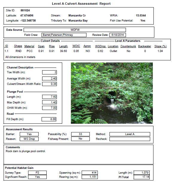
26 Project D Manzanita Creek Manzanita Creek is one of the largest watersheds on Bainbridge Island, and provides habitat for numerous fish and amphibian species. There were multiple restoration opportunities and partial barrier culverts found on this system during WFC s field survey, though the majority were in the headwaters of this system. The most prominant disruption to fish migration and natural stream process was found where Manzanita Creek is piped under Miller Rd. NE. Here, the concrete culvert is 3 ft in diameter and the outfall is perched 1.3 ft. The undersized culvert constricts flow druinging high flow events resulting in substantial downstream erosion and a large plunge pool. This plunge pool has a rock weir at its outlet which was likely installed to raise the water level of the pool and thus improve fish passage to the culvert. There is a second pool and weir approximately 10 ft. downstream. The culvert was also found to be a partial barrier by WDFW culvert inventories cunducted in Additional data and photos are available on WFC s interactive web map at: Solution: Replace the undersized and perched culvert with a larger culvert capable of carring Manzanita Creek s flows during all flood cycles. Remove or redesign the downstream weirs and regrade the stream channel to match the new culvert. Replant the riparian corridor to impove bank stability. 26


27 Miller Rd. NE Culvert outlet perched 1.3 ft into a large plunge pool. Two boulder weirs downstream from the Miller Rd. NE plunge pool. Two cutthroat trout netted upstream of the barrier culvert. 27
28 28
29 29
30 30


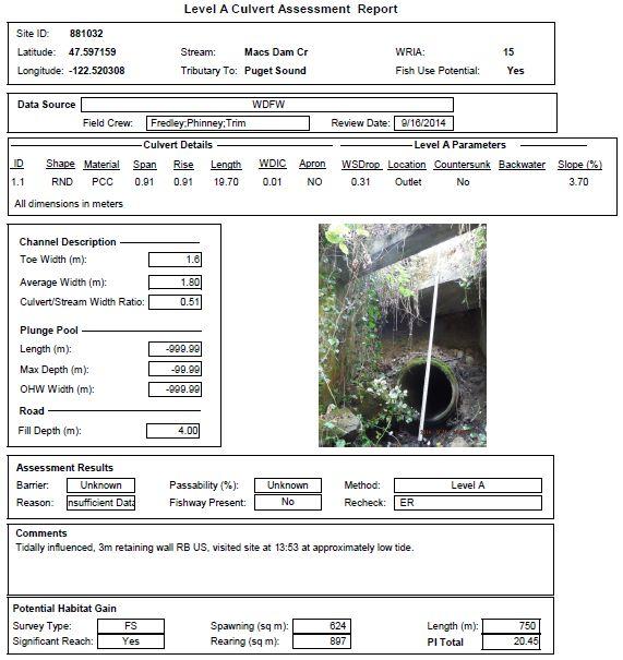
31 Project E Mac s Creek. Mac s Creek contains excellent fish habitat as it meanders through a large swath of undisturbed second growth forest on Bainbridge Island s IslandWood environmental education center. Fish access to this excellent habitat is compromised at the mouth of Mac s Creek, where the stream is piped under NE Country Club Rd. The culvert is undersized, steep, and the outfall is perched 1 ft. Throughtout the extensive field survey no fish were brought to hand above this crossing in the approximatly 4,700 ft of fish habitat. Downstream from the NE Country Club Rd. culvert crossing WFC documented coho, cutthrout trout and sculpin species. There are more barriers on Mac s Creek including a full barrier derilict dam on the IslandWood education center. The education center has shown great interest in removing the dam if the NE County Club Rd. culvert was replaced and fish once again had access to their property. Additional data and photos are available on WFC s interactive web map at: Country Club Road: s.com/?lat= &lng= &zoom=20 Derelict Dam on IslandWood: s.com/?lat= &lng= &zoom=20 31


32 Solution Replace the undersized culvert on NE Country Club Rd. with a large box culvert or bridge. Install grade controls / roughness in the channel above the culvert which is currently incised. Remove the extensive english ivy above the crossing and revegetate the riparian corridor with native plant species. Coordinate with the IslandWood education center to remove the derilict dam and restore fish passage and sediment/wood transport. NE Country Club Rd. culvert outlet perched 1 ft with concrete retaining wall. Mac s Creek with extensive English Ivy at the Blakley Harbor Park 32
33 Derelict dam on the IslandWood education center 33
34 34
35 35
Wild Fish Conservancy Watertype Assessment Project Summary West Sound Watersheds Phase II October 2014
 Wild Fish Conservancy Watertype Assessment Project Summary West Sound Watersheds Phase II http://www.wildfishconservancy.org/maps October 2014 Water typing is the state-sanctioned process of mapping the
FINAL REPORT. Yonkers Creek Migration Barrier Removal Project Wonderstump Road Del Norte County. Submitted By:
 FINAL REPORT Yonkers Creek Migration Barrier Removal Project Wonderstump Road Del Norte County Submitted By: Del Norte County Community Development Department Yonkers Creek Migration Barrier Removal Project
Five Counties Salmonid Conservation Program - Fish Passage Design Workshop. February 2013
 Program - Aquatic Organisms and Stream Crossings Ecological Connectivity A watershed is a network of channels that drain a common boundary. Channel characteristics formed by interaction of precipitation,
East Kitsap Peninsula WRIA 15 Salmon Habitat Restoration Strategy Summary
 East Kitsap Peninsula WRIA 15 Salmon Habitat Restoration Strategy Summary I. Specificity and Focus of the Strategy Strategic Planning Area The planning area for the East Kitsap Peninsula Salmon Habitat
Newaukum Watershed Culvert Assessment
 Newaukum Watershed Culvert Assessment Water Resource Inventory Area 23 Lewis County Conservation District Final Report By: Kelly Verd and Nikki Wilson July 2002 Funded by: Chehalis Fisheries Restoration
Mid-Columbia Fisheries Enhancement Group Annual Report Fiscal Year 06: July 1, 2005 June 30, 2006
 Mid-Columbia Fisheries Enhancement Group Annual Report Fiscal Year 06: July 1, 2005 June 30, 2006 Mission Statement The mission of the Mid-Columbia Fisheries Enhancement Group is to restore self-sustaining
MCCAW REACH RESTORATION
 Final Report MCCAW REACH FISH RESTORATION PHASE B Jack McCaw Inland Empire Action Coalition http://www.wwccd.net/ Phone: 509-956-3777 Hours: 8:00-4:30 Walla Walla County Conservation District Snake River
South Fork Chehalis Watershed Culvert Assessment
 South Fork Chehalis Watershed Culvert Assessment Water Resource Inventory Area 23 Lewis County Conservation District Final Report By: Kelly Verd and Nikki Wilson March 2003 Funded by: The Washington State
Sub-watershed Summaries
 Project Description The Salmon Drift Creek Watershed Council (SDCWC) has focused their efforts in the Salmon River estuary for the past few years. The multifaceted partnership effort is nearing completion
The Calawah River System
 The Calawah River System The Calawah River is the largest tributary of the Bogachiel River and is formed by the confluence of the north and south forks of the Calawah. The two forks of the Calawah, CALAWAH
Pierce County $87,000
 Citizen Advisory Group Meeting/Technical Advisory Group March 16, 2016 Commission Chambers Meeting Summary Attendees Organization Attendees Organization Jamie Glasgow WFC Kathy Peters Kitsap County Amber
Deschutes WRIA 13 Salmon Habitat Recovery Committee SRFB / PSAR Letter of Intent Form
 Deschutes WRIA 13 Salmon Habitat Recovery Committee SRFB / PSAR Letter of Intent Form Project Sponsor: Sponsor Contact lnfo: Project Name: Key Partners: Project Location: lnclude wotershed Project Description:
OVERVIEW OF MID-COLUMBIA FISHERIES ENHANCEMENT GROUP
 Mid-Columbia Fisheries Enhancement Group MISSION STATEMENT The Mid-Columbia Fisheries Enhancement Group is a non-profit organization dedicated to restoring selfsustaining salmon and steelhead populations
Michigan Department of Natural Resources Status of the Fishery Resource Report Page 1
 Michigan Department of Natural Resources 2008-59 Status of the Fishery Resource Report Page 1 Bowens Manistee County, (T24N R16W Sec. 11, 12, 13, 14, 15, 24, and 30). Last surveyed 2008 Mark A. Tonello
FISH PASSAGE IMPROVEMENT in California s Watersheds. Assessments & Recommendations by the Fish Passage Forum
 FISH PASSAGE IMPROVEMENT in California s Watersheds Assessments & Recommendations by the Fish Passage Forum FISH PASSAGE IMPROVEMENT in California s Watersheds The mission of the Fish Passage Forum is
Interim Guidance Fish Presence Absence
 Interim Guidance Fish Presence Absence Source: Forest Practices Act Guidance for Division 635 of the forest practices act dealing with stream classification when no fish surveys have been done (referenced
COLUMBIA LAKE DAM REMOVAL PROJECT
 COLUMBIA LAKE DAM REMOVAL PROJECT Major Goals of the Columbia Lake Dam Removal: Reconnect 10 miles of the Paulins Kill River to the Delaware River, restoring natural flow regime and sediment transport.
The Blue Heron Slough Conservation Bank
 1 The Blue Heron Slough Conservation Bank CONSERVATION BANKING July 19-23, 2010 CASE STUDY SERIES The Blue Heron Slough Conservation Bank (Washington) I. OVERVIEW & BACKGROUND: Location: Snohomish River
Follow this and additional works at:
 University of Massachusetts - Amherst ScholarWorks@UMass Amherst International Conference on Engineering and Ecohydrology for Fish Passage International Conference on Engineering and Ecohydrology for Fish
Project Report for Marsh Creek and Albion River Instream Fish Barrier Removal Flynn Creek Road, CR 135, M.P. 8.1 and 8.3
 Project Report for Marsh Creek and Albion River Instream Fish Barrier Removal Flynn Creek Road, CR 135, M.P. 8.1 and 8.3 Project Title: Marsh Creek and Albion River Instream Fish Barrier Removal, Flynn
COA-F17-F-1343 YEAR END REPORT
 DAVE MARSHALL SALMON RESERVE RESTORATION, MAINTENANCE, AND UPGRADES YEAR END REPORT Prepared for: Fish and Wildlife Compensation Program Prepared by: Edith Tobe, RPBio, Executive Director Box 1791, Squamish,
Washington State Fish Passage Barrier Removal Projects. Casey Kramer, PE WSDOT State Hydraulics Engineer
 Washington State Fish Passage Barrier Removal Projects Casey Kramer, PE WSDOT State Hydraulics Engineer 2014 National Hydraulic Engineering Conference Iowa City, IA August 20 th, 2014 WSDOT Fish Passage
Annual Report for Fiscal Year and Future Plans for the Tillamook Bay Watershed Council
 Annual Report for Fiscal Year 2012-2013 and Future Plans for the Tillamook Bay Watershed Council A report prepared for the Tillamook County Board of Commissioners August 2013 Table of Contents: Recently
OKANAGAN RIVER RESTORATION INITIATIVE - FAQ
 OKANAGAN RIVER RESTORATION INITIATIVE - FAQ Initiative background: The health of the q awsitk w (Okanagan River) has been severely impacted by the channelization works that occurred in the mid-1950 s.
X.B WETLANDS ROGUE RIVER ESTUARY
 X.B WETLANDS ROGUE RIVER ESTUARY The Rogue River has a drainage area of 5,100 square miles, yet the estuary of the Rogue River is one of the smallest in Oregon, measuring approximately 1,880 acres during
Puget Sound Nearshore Ecosystem Restoration Project Restore America s Estuaries Conference 2012 Tampa, FL
 Restore America s Estuaries Conference 2012 Tampa, FL presented by: Theresa Mitchell, WA Dept. of Fish & Wildlife Nearshore General Investigation Change Analysis: Comparison of historical and current
Packwood Hydroelectric Project Barrier Analysis December 12, 2006
 Packwood Hydroelectric Project Barrier Analysis December 12, 2006 Study Area Natural barriers to upstream fish passage on Lake Creek at RM 1.03 and RM 1.95 Snyder Creek culvert under the Project tailrace
STEELHEAD SURVEYS IN OMAK CREEK
 STEELHEAD SURVEYS IN OMAK CREEK 2002 Annual Report Prepared by Chris Fisher John Arterburn Colville Confederated Tribes Fish and Wildlife Department P.O. Box 150 Nespelem, WA 99155 Prepared for Project
3. The qualification raised by the ISRP is addressed in #2 above and in the work area submittal and review by the ISRP as addressed in #1.
 Please find attached a response from The Confederated Tribes of the Warm Springs Reservation of Oregon (CTWSRO) for Project # 2008-301-00, Habitat Restoration Planning, Design and Implementation within
Downstream Migrant Trapping in Russian River Mainstem, Tributaries, and Estuary
 Downstream Migrant Trapping in Russian River Mainstem, Tributaries, and Estuary Introduction In September 2008, the National Marine Fisheries Service issued the Russian River Biological Opinion, which
Restoring the Kootenai: A Tribal Approach to Restoration of a Large River in Idaho
 Restoring the Kootenai: A Tribal Approach to Restoration of a Large River in Idaho Susan Ireland, Kootenai Tribe of Idaho Future of our Salmon Conference Technical Session August 2016 Healthy Floodplains,
Study Update Tailrace Slough Use by Anadromous Salmonids
 Study Update Tailrace Slough Use by Anadromous Salmonids Goals and Objectives Identify what anadromous salmonids use the tailrace slough by: Life Stage (Juvenile, migrating and spawning adults) Timing
Clear Creek Fish Passage and Instream Flow Enhancement Phase II
 Upper Columbia Regional Application 2017 Clear Creek Fish Passage and Instream Flow Enhancement Phase II Trout Unlimited 103 Palouse Street #14 509-888-0970 PRISM # 17-1192 HWS # 04-CHW-2017-02 Anticipated
Climate Change Adaptation and Stream Restoration. Jack Williams;
 Climate Change Adaptation and Stream Restoration Jack Williams; jwilliams@tu.org 1 Goals for this presentation Develop strategies for adapting streams to climate impacts by Thinking like a watershed Understanding
Aquatic Organism Passage at Road-Stream Crossings CHUCK KEEPORTS FOREST HYDROLOGIST ALLEGHENY NATIONAL FOREST WARREN, PENNSYLVANIA
 Aquatic Organism Passage at Road-Stream Crossings CHUCK KEEPORTS FOREST HYDROLOGIST ALLEGHENY NATIONAL FOREST WARREN, PENNSYLVANIA TOPICS COVERED Aquatic Organism Passage (AOP) Benefits of AOP Crossings
Culvert Design for Low and High Gradient Streams in the Midwest. Dale Higgins, Hydrologist Chequamegon-Nicolet National Forest
 Culvert Design for Low and High Gradient Streams in the Midwest Dale Higgins, Hydrologist Chequamegon-Nicolet National Forest Overview Culvert Design Considerations Hydraulic Terms Culvert Impacts Low
Chadbourne Dam Repair and Fish Barrier
 Chadbourne Dam Repair and Fish Barrier Final Report for the Western Native Trout Initiative Prepared by: Carol Endicott Yellowstone Cutthroat Trout Conservation Biologist Montana Fish, Wildlife & Parks
CHAPTER 4 DESIRED OUTCOMES: VISION, GOALS, AND OBJECTIVES
 CHAPTER 4 DESIRED OUTCOMES: VISION, GOALS, AND OBJECTIVES Vision One of the first steps in developing this Plan was articulating a vision - a clear statement of what the Plan strives to achieve and what
PRE- PROPOSAL FORM - Lewis River Aquatic Fund
 PRE- PROPOSAL FORM - Lewis River Aquatic Fund 1. Applicant organization. USDA Forest Service Gifford Pinchot National Forest 2. Organization purpose Resource management agency 3. Project manager (name,
Kennebunk River Road-Stream Crossing Survey Prepared by: Wells National Estuarine Research Reserve 342 Laudholm Farm Road Wells, Maine 04090
 Kennebunk River Road-Stream Crossing Survey 2010 Prepared by: Wells National Estuarine Research Reserve 342 Laudholm Farm Road Wells, Maine 04090 Acknowledgements The 2010 Kennebunk River Road-Stream
Klickitat County Shoreline Master Program Update. Open House March 15, 2017
 Klickitat County Shoreline Master Program Update Open House March 15, 2017 Agenda 6:00 6:10 Welcome 6:10 6:40 Presentation SMP Update Process Shoreline Analysis review 6:40 8:00 Open House Topics SMP Process
PROJECT TO INSTALL LARGE WOOD HABITAT STRUCTURES IN THE CARMEL RIVER USING CALIFORNIA DEPARTMENT OF FISH AND GAME GRANT FUNDS
 PROJECT TO INSTALL LARGE WOOD HABITAT STRUCTURES IN THE CARMEL RIVER USING CALIFORNIA DEPARTMENT OF FISH AND GAME GRANT FUNDS The Monterey Peninsula Water Management District (MPWMD), in cooperation with
Illinois Lake Management Association Conference March 23, 2018 By Trent Thomas Illinois Department of Natural Resources Division of Fisheries
 Illinois Lake Management Association Conference March 23, 2018 By Trent Thomas Illinois Department of Natural Resources Division of Fisheries Sources of Habitat Impairment Sedimentation Channelization
Project Completion Abstract Fish Passage Activity ( Engineering Activities)
") Project Completion Abstract Fish Passage Activity ( Engineering Activities) SUBMIT COMPLETED FORM TO DISTRICT MANAGER AND FIA ADMINISTRATOR AFTER PROJECT COMPLETION SECTION A GENERAL INFORMATION Recipient:
Project Completion Abstract Fish Passage Activity ( Engineering Activities) SUBMIT COMPLETED FORM TO DISTRICT MANAGER AND FIA ADMINISTRATOR AFTER PROJECT COMPLETION SECTION A GENERAL INFORMATION Recipient:
GRAND RAPIDS RESTORATION GRAND RAPIDS REVITALIZATION
 GRAND RAPIDS RESTORATION RETURNING THE RAPIDS TO THE GRAND WHY IS THIS PLACE CALLED GRAND RAPIDS? We have been asking for over 100- years, where are the rapids? WHY IS THIS PLACE CALLED GRAND RAPIDS? compare
Trout Unlimited Comments on the Scope of Environmental Impact Statement for the Constitution Pipeline Project, Docket No. PF12-9
 October 9, 2012 Kimberly D. Bose, Secretary Federal Energy Regulatory Commission 888 First Street, NE, Room 1A Washington, DC 20426 RE: Trout Unlimited Comments on the Scope of Environmental Impact Statement
Downstream Migrant Trapping in Russian River Mainstem, Tributaries, and Estuary
 Downstream Migrant Trapping in Russian River Mainstem, Tributaries, and Estuary Introduction In September 2008, the National Marine Fisheries Service issued the Russian River Biological Opinion, which
Fish Passage Culvert Assessment for Cahilty Creek Watershed FIA Project #
 Fish Passage Culvert Assessment for Cahilty Creek Watershed FIA Project # 4602004 Prepared for Weyerhaeuser Company Ltd. Jason Ladyman R.P.F. 1550 Mission Flats Road PO Box 40 Kamloops BC V2C 5K3 Prepared
P.O. Box 65 Hancock, Michigan USA fax
 This PDF file is a digital version of a chapter in the 2005 GWS Conference Proceedings. Please cite as follows: Harmon, David, ed. 2006. People, Places, and Parks: Proceedings of the 2005 George Wright
Strategies for mitigating ecological effects of hatchery programs
 Strategies for mitigating ecological effects of hatchery programs Some case studies from the Pacific Northwest Kathryn Kostow Oregon Department of Fish and Wildlife Ecological risks occur when the presence
WHATCOM COUNTY FISH PASSAGE BARRIER INVENTORY FINAL REPORT
 WHATCOM COUNTY FISH PASSAGE BARRIER INVENTORY FINAL REPORT January, 2006 IAC Project Number: 01-1258 N Project Sponsor: Whatcom County Public Works 5280 Northwest Drive, Suite C Bellingham, WA 98226 Grant
Puget Sound Shorelines. Waves and coastal processes. Puget Sound shorelines: Effects of beach armoring
 Puget Sound Shorelines Puget Sound shorelines: Effects of beach armoring Waves and coastal processes Factors affecting wave energy hitting the coast Processes transporting sediment along coastlines What
Columbia Lake Dam Removal Project
 Columbia Lake Dam Removal Project Major Goals of the Columbia Lake Dam Removal: Reconnect 10 miles of the Paulins Kill River to the Delaware River, restoring natural flow regime and sediment transport.
(Revised February,2005) CULVERTS, BRIDGES, AND FORDS
 CULVERTS, BRIDGES, AND FORDS") GUIDE TO STREAM CROSSINGS (Revised February,2005) CULVERTS, BRIDGES, AND FORDS Culverts, bridges, and fords are all methods used to cross-streams. Culverts are the most common stream crossing structure.
GUIDE TO STREAM CROSSINGS (Revised February,2005) CULVERTS, BRIDGES, AND FORDS Culverts, bridges, and fords are all methods used to cross-streams. Culverts are the most common stream crossing structure.
Site Tour, August 24, Fish Science - Big Lake Coho Salmon Migration and Habitat Use
 Matanuska-Susitna Basin Salmon Habitat Partnership Site Tour, August 24, 2015 Part 1 of Tour Big Lake watershed Fish Science - Big Lake Coho Salmon Migration and Habitat Use Presenter: Jon Gerken (U.S.
5B. Management of invasive species in the Cosumnes and Mokelumne River Basins
 5B. Management of invasive species in the Cosumnes and Mokelumne River Basins Cosumnes River The Cosumnes River basin has a number of distinct habitat types that require different management strategies
APPENDIX D: North Fork Nooksack Sub-basin Report
 APPENDIX D: North Fork Nooksack Sub-basin Report WHATCOM COUNTY FISH PASSAGE ASSESSMENT SUBBASIN REPORT NORTH FORK NOOKSACK RIVER Description of Sub-basin The North Fork Nooksack River originates at an
CALIFORNIA SALMONID STREAM HABITAT RESTORATION MANUAL APPENDIX IX-A CULVERT CRITERIA FOR FISH PASSAGE INTRODUCTION
 APPENDIX IX-A STATE OF CALIFORNIA RESOURCES AGENCY DEPARTMENT OF FISH AND GAME CULVERT CRITERIA FOR FISH PASSAGE For habitat protection, ecological connectivity should be a goal of stream-road crossing
Massachusetts Stream Crossing Case Studies
 Massachusetts Stream Crossing Case Studies Amy Singler Associate Director, River Restoration Program Carrie Banks River Continuity Coordinator Case Studies: Public Benefits: Movement of goods and people
Conserving the Forests, Lakes and Streams of Northeast Michigan
 4241 Old US 27 South, Suite 2, Gaylord, Michigan 49735 (989) 448-2293 www.huronpines.org info@huronpines.org Prioritized Restoration Projects in the AuSable River Watershed Summer 2015 Update from Huron
STREAM SURVEY File form No..
 scanned for KRIS THE RESOURCES AGENCY OF CALIFORNIA California Department of Fish and Game STREAM SURVEY File form No.. Date: September 4, 1969. NAME: North Fork Schooner Gulch Creek COUNTY: Mendocino.
MUCKLESHOOT INDIAN TRIBE Fisheries Division nd Avenue SE Auburn, Washington Phone: (253) Fax: (253)
 Fax: (253)") MUCKLESHOOT INDIAN TRIBE Fisheries Division 39015-172nd Avenue SE Auburn, Washington 98092-9763 Phone: (253) 939-3311 Fax: (253) 931-0752 U.S. Army Corps of Engineers Regulatory Branch Attn: Karen Urelius
MUCKLESHOOT INDIAN TRIBE Fisheries Division 39015-172nd Avenue SE Auburn, Washington 98092-9763 Phone: (253) 939-3311 Fax: (253) 931-0752 U.S. Army Corps of Engineers Regulatory Branch Attn: Karen Urelius
RESTORING 400 ACRES OF TIDAL MARSH IN THE SNOHOMISH RIVER DELTA
 RESTORING 400 ACRES OF TIDAL MARSH IN THE SNOHOMISH RIVER DELTA Marya Moses, Danny Moses, Neil Moses, and Robert Moses fish on Tulalip Bay, near the mouth of the Snohomish River Estuary. QWULOOLT IS A
Perspectives of a State Director Selective fisheries as a tool in fisheries management and salmon recovery
 Perspectives of a State Director Selective fisheries as a tool in fisheries management and salmon recovery Jeffrey P. Koenings, PhD. Washington Department of Fish and Wildlife American Fisheries Society
SELBY CREEK SILVERADO TRAIL CULVERT FISH PASSAGE ASSESSMENT
 SELBY CREEK SILVERADO TRAIL CULVERT FISH PASSAGE ASSESSMENT NAPA COUNTY, CALIFORNIA PREPARED BY NAPA COUNTY RESOURCE CONSERVATION DISTRICT 1303 JEFFERSON ST. SUITE 500B NAPA, CALIFORNIA 94559 WWW.NAPARCD.ORG
LONE TREE POCKET ESTUARY RESTORATION 2004 FISH SAMPLING AND PRE-RESTORATION PROJECT MONITORING REPORT
 Skagit River System Cooperative 11426 Moorage Way P.O. Box 368 LaConner, WA 98257-368 Phone: 36-466-7228 Fax: 36-466-447 www.skagitcoop.org LONE TREE POCKET ESTUARY RESTORATION 24 FISH SAMPLING AND PRE-RESTORATION
Columbia Lake Dam Removal Project
 Columbia Lake Dam Removal Project The Columbia Lake dam located 1/4 mile upstream of the Paulins Kill River's confluence with the Delaware River in Knowlton Township, Warren County has been proposed for
Executive Summary. Map 1. The Santa Clara River watershed with topography.
 Santa Clara River Steelhead Trout: Assessment and Recovery Opportunities December 2005 Prepared By: Matt Stoecker and Elise Kelley, Ph.D. University of California, Santa Barbara Prepared For: The Santa
11426 Moorage Way P.O. Box 368 LaConner, WA Phone: Fax:
 Skagit River System Cooperative 11426 Moorage Way P.O. Box 368 LaConner, WA 98257-368 Phone: 36-466-7228 Fax: 36-466-447 www.skagitcoop.org BULL TROUT USE OF SWINOMISH RESERVATION WATERS Eric Beamer, Rich
Black Sturgeon Regional Plan
 Black Sturgeon Regional Plan This is one of twenty Regional Plans that support implementation of the Lake Superior Biodiversity Conservation Strategy (Strategy). The Strategy, prepared and overseen by
FSOC Upstream Fish Passage Guidance Document
 FSOC Upstream Fish Passage Guidance Document STEP 1: Identify species and life stages in need of fish passage STEP 2: Identify fishway options and species applicability STEP 3 Fish passage criteria review
The Salmonid Species. The Salmonid Species. Definitions of Salmonid Clans. The Salmonid Species
 The Salmonid Species The Salmonid Species N. American salmon (2 more Asian species) Chinook ( King ) Coho ( Silver ) Sockeye Chum ( Dog ) Pink ( Humpy ) Sea-run trout Steelhead, Cutthroat, Dolly Varden
Fish Passage Culvert Inspection (FPCI) Nicklen Creek Watershed
 Nicklen Creek Watershed") Fish Passage Culvert Inspection (FPCI) Nicklen Creek Watershed FPCI Sites funded by FIA Prepared for: Tolko Industries Ltd., Okanagan Regional Woodlands & British Columbia Timber Sales, Okanagan-Shuswap
Fish Passage Culvert Inspection (FPCI) Nicklen Creek Watershed FPCI Sites funded by FIA Prepared for: Tolko Industries Ltd., Okanagan Regional Woodlands & British Columbia Timber Sales, Okanagan-Shuswap
Rhode Island Department of Environmental Management Division of Fish and Wildlife American Shad Habitat Plan for the Pawcatuck River
 Rhode Island Department of Environmental Management Division of Fish and Wildlife American Shad Habitat Plan for the Pawcatuck River Prepared by: Phil Edwards, Rhode Island Department of Environmental
Eastern Brook Trout. Roadmap to
 Eastern Brook Trout Roadmap to CONSERVATION Our Brook Trout heritage he wild Brook Trout is an American symbol of persistence, adaptability, and the pristine wilderness that covered North America prior
Assessing Ecosystem Impacts from Road Stream Crossings through Community Involvement
 Assessing Ecosystem Impacts from Road Stream Crossings through Community Involvement Background Why is the NH Fish and Game Department interested in culverts? Block fish migration Reduce opportunities
WFC 50 California s Wild Vertebrates Jan. 11, Inland Waters (Lakes and Streams) Lisa Thompson
 Lisa Thompson") Inland Waters: Lakes and Streams WFC 50 11 January 2011 Lisa Thompson Fisheries Extension Specialist Wildlife, Fish, & Conservation Biology Department University of California, Davis Take home messages
Inland Waters: Lakes and Streams WFC 50 11 January 2011 Lisa Thompson Fisheries Extension Specialist Wildlife, Fish, & Conservation Biology Department University of California, Davis Take home messages
The Restoration of Jimmycomelately Creek
 The Undevelopment of Jimmycomelately Creek & Estuary Jimmycomelately The Restoration of Jimmycomelately Creek The Jimmycomelately (JCL) watershed comprises an area of 15.4 square miles, with JCL being
2012 Bring Back the Natives Awarded Projects
 2012 Bring Back the Natives Awarded Projects EZG # Organization Project Title Project Description Location Description Total Award Amount Grantee Non- Federal Match 31904 Sanctuary Forest, Inc. Mattole
Kootenai River Habitat Restoration Program. Kootenai Tribe of Idaho - January 27, 2014 Presentation for Kootenai Valley Resource Initiative
 Kootenai River Habitat Restoration Program Kootenai Tribe of Idaho - January 27, 2014 Presentation for Kootenai Valley Resource Initiative Decline of native species Kootenai River White Sturgeon ENDANGERED
Southern Oregon Coastal Cutthroat Trout
 Species Management Unit Description Southern Oregon Coastal Cutthroat Trout The Southern Oregon Coastal Cutthroat Trout SMU includes all populations of cutthroat trout inhabiting ocean tributary streams
1.Mill Creek Watershed Summary Description and Land Use
 1.Mill Creek Watershed Summary Description and Land Use Table xxx: Mill Creek Watershed Overview Watershed Size 31,435 acres/49.1 sq miles/ 127.1 sq km Elevation Range 5,594 feet [4,967-10,561] Stream
Ned Currence, Nooksack Indian Tribe
 Ned Currence, Nooksack Indian Tribe Problem Status Distribution Habitat Hatcheries Harvest 25000 20000 Natural-Origin Spawners 15000 10000 22500 5000 0 Historic catch Spawners (2011-2015) Problem Status
ADOPT-A-STREAM WATERSHED APPROACH COMMUNITY-BASED STEWARDSHIP. Nova Scotia Salmon Association March 2005
 ADOPT-A-STREAM A WATERSHED APPROACH TO COMMUNITY-BASED STEWARDSHIP Nova Scotia Salmon Association March 2005 This manual is a revised and updated version of the 1994 Adopt-a-Stream manual that was prepared
San Lorenzo Valley Water District, Watershed Management Plan, Final Version Part I: Existing Conditions Report
 LIST OF FIGURES Figure 1-1. Map of the San Lorenzo River watershed Figure 2-1. The Santa Cruz Mountains Bioregion Figure 2-2. Protected areas within the San Lorenzo River watershed Figure 2-3. Primary
Big Spring Creek Habitat Enhancement and Fishery Management Plans
 Big Spring Creek Habitat Enhancement and Fishery Management Plans November 5, 2012 Big Spring Events and Activities Center Newville, PA Charlie McGarrell Regional Habitat Biologist Pennsylvania Fish and
Freshwater Fish Assessment
 Alaska Department of Transportation & Public Facilities Seward Highway MP 7-9 6-7 Freshwater Fish Assessment March 14, 8 Prepared by HDR Alaska C Street, Suite 3 Anchorage, Alaska 993 Project Number: BR-BH-NH-OA3
10 is bounded by wetlands between RM 1.8 and 3.1 on the south shore and more are scattered
 The Ozette System The Ozette watershed is made up of several lakes and large streams that combine to a total drainage area of 88.4 square miles. The most significant feature of the Ozette watershed is
6. FRESHWATER REACH SUMMARY
 6. FRESHWATER REACH SUMMARY This chapter describes the freshwater shorelines that are within the jurisdiction of the County s SMP (in WRIAs 18, 19, and a portion of 17, excluding incorporated areas) (see
Okanagan Sockeye Reintroduction
 Okanagan Sockeye Reintroduction Backgrounder Elders accounts, and other forms of Traditional Ecological Knowledge (TEK) tell us that many species of salmon once came into the Okanagan Valley and tell us
California Steelhead: Management, Monitoring and Recovery Efforts
 California Steelhead: Management, Monitoring and Recovery Efforts Jonathan Nelson Steelhead Management, Research and Restoration Program Oncorhynchus mykiss irideus California Steelhead - Hot Topics Implementation
Eastern Brook Trout Joint Venture Annual Report The Nature Conservancy 2013
 Eastern Brook Trout Joint Venture Annual Report The Nature Conservancy 2013 2013 Annual Performance Report Enhancing Connectivity in the Ash-Black Rock Sub-basin of the West Branch Narraguagus River. Project
Understanding the Impacts of Culvert Performance on Stream Health
 Understanding the Impacts of Culvert Performance on Stream Health Kristin Thomas Aquatic Ecologist Michigan Trout Unlimited Transportation and the Environment Conference 12/5/2018 Importance of adequately
DEADWOOD CREEK FISH PASSAGE IMPROVEMENT PROJECT
 DEADWOOD CREEK FISH PASSAGE IMPROVEMENT PROJECT Coho Salmon in Deadwood Creek Project Area - November 2, 2004 FINAL REPORT National Fish and Wildlife Foundation Project #2002-0368-014 CA Department of
PROTECTING LAND & RESTORING RIVERS FOR SALMON & STEELHEAD
 PROTECTING LAND & RESTORING RIVERS FOR SALMON & STEELHEAD Whychus Creek at Camp Polk Meadow Preserve. Photo: Russ McMillan Top photo: Deschutes River Conservancy 1 Photo: Byron Dudley A Unique Collaboration
Fish Passage Assessment of Private Stream Crossings on Lower Stonybrook Creek
 Fish Passage Assessment of Private Stream Crossings on Lower Stonybrook Creek Prepared by: Michael Love & Associates In cooperation with: Center for Ecosystem Management and Restoration Funded by: Coastal
Minnesota Department of Natural Resources Division of Fish and Wildlife Section of Fisheries. Stream Survey Report. Luxemburg Creek.
 Minnesota F-29-R(P)-24 Area 315 Study 3 March 2016 Minnesota Department of Natural Resources Division of Fish and Wildlife Section of Fisheries Stream Survey Report Luxemburg Creek 2015 Mark Pelham Sauk
APPENDIX B: South Fork Nooksack Sub-basin Report
 APPENDIX B: South Fork Nooksack Sub-basin Report WHATCOM COUNTY FISH PASSAGE ASSESSMENT SUB-BASIN REPORT SOUTH FORK NOOKSACK RIVER Description of Sub-basin The South Fork Nooksack River originates in the
Fish Passage at Road Crossings Assessment Boise National Forest FY 2004
 Culvert Inventory Summary 2004 - Boise National Forest Fish Passage at Road Crossings Assessment Boise National Forest FY 2004 Feather River at Road #135 Crossing By Michael S. Kellett, Fishery Biologist
Oregon Department of Transportation (ODOT) Culvert Repair Fish Passage Pilot Programmatic Agreement Final ODFW Report
 Culvert Repair Fish Passage Pilot Programmatic Agreement Final ODFW Report") Oregon Department of Transportation (ODOT) Culvert Repair Fish Passage Pilot Programmatic Agreement 2014-17 Final ODFW Report Prepared by Pete Baki June 27, 2018 Table of Contents 1 Background 4 Culvert
Oregon Department of Transportation (ODOT) Culvert Repair Fish Passage Pilot Programmatic Agreement 2014-17 Final ODFW Report Prepared by Pete Baki June 27, 2018 Table of Contents 1 Background 4 Culvert