APPENDIX B: South Fork Nooksack Sub-basin Report
|
|
|
- Alisha Welch
- 5 years ago
- Views:
Transcription
1 APPENDIX B: South Fork Nooksack Sub-basin Report
2 WHATCOM COUNTY FISH PASSAGE ASSESSMENT SUB-BASIN REPORT SOUTH FORK NOOKSACK RIVER Description of Sub-basin The South Fork Nooksack River originates in the National Forest east of the Twin Sisters and flows roughly 38 miles to its confluence with the North Fork near Deming, WA (figure 1 and 2). The upper watershed flows through a relatively confined valley with steep gradient tributaries forming alluvial fans along the valley margins. These tributaries include Bell, Wanlick, Dye, Howard, Deer, Roaring, Plumbago Cavanaugh, Edfro, and Skookum Creeks. Downstream of the Saxon Road bridge, the South Fork valley widens and the river corridor consists of a sinuous single thread channel bordered by broad, low relief river terraces. Frequent rock revetments confine the river to its current alignment. The river flows along the western valley wall between Acme and its confluence with the North Fork near Deming. Numerous alluvial fan forming tributary streams are found along the western margin of the river, including Jones, McCarty, Hardscrabble, Sygitowtcz, and Todd Creeks. East of the river, tributary creeks descend from the foothills forming alluvial fans at the valley margin, and then meander across the wide river floodplain in slough like channels before entering the main stem. These streams include Hutchinson, Landing Strip Creeks, Black Slough, Tawes Creek, and several unnamed tributaries. The primary land use on the steep forested hillsides surrounding the South Fork is commercial logging. Agricultural and scattered rural residential activities dominate the river floodplain and alluvial fans that border the lower river. The communities of Acme and Van Zant comprise the only urban development in the valley. Land use jurisdiction is split between Whatcom in the low-lying areas; United States Forest Service in the upper watershed; and the state Department of Natural Resources in the foothills (Whatcom, 1997). As noted above, numerous small tributary streams enter the lower South Fork Nooksack from the steep forested hillsides that flank the river. These include Jones, McCarty, Hardscrabble, Sygitowtcz, and Todd Creeks, and numerous unnamed tributary streams. These streams share many characteristics. The upper watershed is typically steep gradient cascade and falls which transition abruptly to moderate gradient, gravel rich streams on alluvial fans that border the river floodplain. Streamside vegetation is continuous conifer forest on the hill-slope, and fragmented deciduous/conifer forest and pasture on the alluvial fan. Fish use is usually restricted to the short alluvial fan reaches and commonly include coho salmon and steelhead and cutthroat trout. Several of the larger streams also support small runs of Chinook salmon, and native char (Whatcom, 1994, NWIFC, 2003). eek is the largest tributary on the east side of the lower South Fork. The stream gradient is moderate for most of its length except for short stretch of steep cascades below RM 2.0. Stream substrate is predominantly gravel/cobble with well-developed pool/riffle complexes. Streamside vegetation consists of mixed deciduous/conifer forest for the entire length of the stream. Fish use is heavy below RM 1.6 and includes Chinook, coho, pink, chum and sockeye salmon, steelhead and cutthroat trout, and native char. Steelhead and cutthroat trout, and native char and brook trout utilize the reach above the cascades at RM 1.6 (Whatcom, 1994, NWIFC, 2003). Landing Strip Creek flows northward along an low gradient, abandoned river channel and enters the South Fork on the west bank near Acme. Several seasonal tributary streams originate on the 2
3 foothills to the west and form small gravel-rich alluvial fans before flowing through marshy lowlands to join the main stem. Streamside vegetation is fragmented deciduous forest, beaver marsh, and wet pasture. Substrate varies from gravel-rich reaches on the alluvial fans to organic mud and silt in the marshes and beaver ponds. Fish use is primarily coho salmon, and cutthroat and steelhead trout (Whatcom, 1994, NWIFC, 2003). Black Slough, like Landing Strip Creek, originates as several small tributary streams that drain the foothills east of the river. These streams form gravel-rich alluvial fans along the valley margin before entering large forested swamps and wet pastures on the river floodplain. Flow from these wetlands coalesces in a north flowing channel that discharges to the South Fork near Van Zandt. Streamside vegetation is fragmented deciduous forest, forested swamp and marshy pasture. Substrate varies from gravel-rich alluvial fan reaches to organic mud and silt in the swamps and marshes. Fish use is primarily coho salmon and cutthroat and steelhead trout, with some Chinook rearing in the lower reaches (Whatcom, 1994, NWIFC, 2003). Tawes Creek originates on the steep hillsides of the Van Zant Dike and flows to Williams Lake along the toe of an ancient landslide. From Williams Lake, the stream follows a moderate gradient channel punctuated by several beaver dams to a large spirea marsh adjacent to the South Fork channel. An impassable dam is located at the outlet of Williams Lake that blocks fish passage. Except for the spirea marsh, streamside vegetation is mixed conifer/deciduous forest for its entire length. Below Williams Lake, channel substrate is composed of gravel in the riffle areas and sand/silt in the pools and beaver ponds. Above Williams Lake, gravel is more abundant on the alluvial fans that fringe the toe of Van Zandt Dike. Fish use is primarily coho and chum salmon, and cutthroat and steelhead trout (Whatcom, 1994, NWIFC, 2003). Data Integration from Previous Projects In the South Fork Sub-basin, previous barrier data from Whatcom ( roads), Washington Department of Fish and Wildlife (WDFW) for State highways, and Nooksack Salmon Enhancement Association are standardized and integrated into the WDFW Fish Passage and Diversion Screening Inventory (FPDSI) data base format and is included in the final summary table. Since no Forest Service barriers are in anadromous waters, their data has not been included. Reach Prioritization Summary Prior to contacting landowners for access permission, inventory staff met with tribal and state biologists, and local fisheries professionals to identify priority stream reaches that had not been previously inventoried. In the interest of efficiency, we did not include areas with previously completed inventories, or where barrier inventories are required by law, and focused on reaches where information was lacking. Most eek culvert barriers were identified by Washington Trout in the Hutchinson Creek Watershed Analysis (Currents, 2004). With the exception of the blockage at the outlet of Musto Marsh, virtually all forestry related passage barriers have been corrected, although this assessment determined that three on Washington Department of Natural Resources (DNR) ownership in eek continue to be barriers. For the U.S. Forest Service ownership, their assessment is complete, and the two blockages in the upper South Fork (Bell and Heart Creeks) are resident trout areas. Barrier information is essentially completed in forested areas including those in Skagit (Currents, 2004). 3
4 Similar inventories have been completed by the DNR and the Washington Department of Transportation (WSDOT) for their respective ownership. The DNR will be correcting blockages on state land under Road Maintenance and Abandonment Plans (RMAPs) under the Forest Practices rules. These plans cover the vast majority of the private and state timber management areas. Crown Pacific Inc., WSDNR State lands, Bloedel Timber, Seattle City Light, Hampton Resources Inc., have all prepared and implemented an RMAP for their respective ownerships in the South Fork Sub-basin (Currents, 2004). WSDOT and Whatcom Public Works will be repairing barriers on roadways as part of their ongoing maintenance and repair program. In order to insure that all anadromous tributary systems in the South Fork Sub-basin received a stream-based barrier inventory, the following tributaries were assessed for barriers to fish passage: eek: From the confluence to the end of anadromous use. Black Slough: From the confluence to the end of anadromous use. Tawes Creek: From the confluence to the end of anadromous use. Landing Strip Creek: From the confluence to the end of anadromous use. Caron Road trib., MP 0.376: From the confluence to the end of anadromous use Shoronbush Road tribs. ( , , ): From the confluence to the end of anadromous use Linnel Road trib. MP 0.090: From the confluence to the end of anadromous use Hillside Road tribs. MP and 1.04: From the confluence to the end of anadromous use Clipper Road tribs. MP and 0.189: From the confluence to the end of anadromous use Homesteader Road tribs. MP and 0.719: From the confluence to the end of anadromous use Standard Road trib MP 0.943: From the confluence to the end of anadromous use (Jones Creek): From the confluence to the end of anadromous use. Turkington Road trib MP 0.572: From the confluence to the end of anadromous use (Saxon Road trib MP 2.36): From the confluence to the end of anadromous use. Old eek System: From the confluence to the end of anadromous use. Nessett Creek System: From the confluence to the end of anadromous use. Syre Property trib. (RM 7.31): From the confluence to the end of anadromous use Barrier Assessment Prior to conducting fieldwork, landowners adjacent to stream inventory sites provided written or verbal permission for field crews to access their property. Field crews did not evaluate culverts or habitat conditions on land parcels in which property access was denied. Two levels of assessment are included in this report. The first is a road inventory conducted by Whatcom Public Works staff that identified fish blocking culverts on the road system for known and possible fish bearing streams. The second level of assessment was a stream-based inventory by Nooksack Tribe and Nooksack Salmon Enhancement Association field crews on priority stream reaches identified in the reach prioritization effort described above. All human made features in priority stream reaches were geo-referenced using GPS and evaluated for their ability to pass fish. Field evaluation and data collection followed the 4
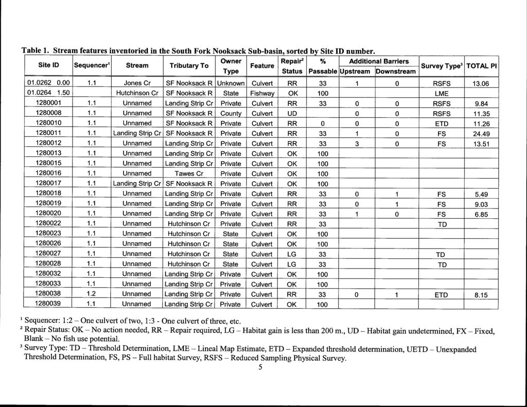
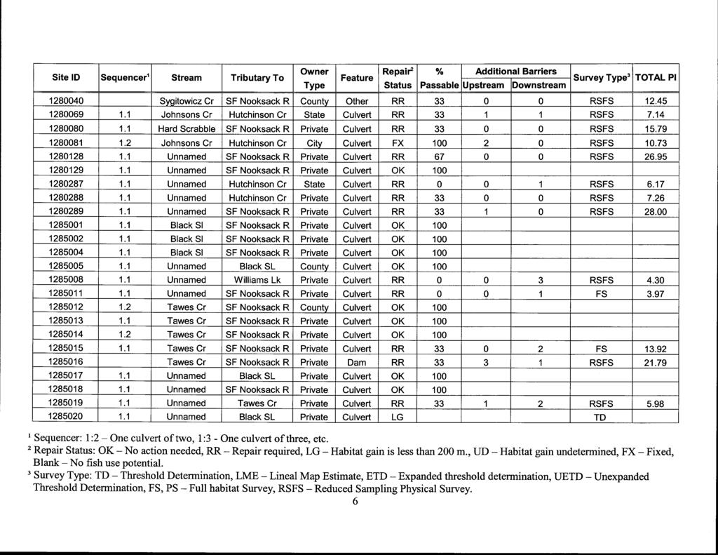
5 methodologies described in the Fish Passage Barrier and surface Water Diversion Screening Assessment and Prioritization Manual (WDFW 2000). 1.0 Summary of Results Figure 1 is a map of the South Fork Sub-basin showing the location and site ID number of each feature inventoried. Table 1 summarizes the inventory results sequentially by site ID number for the South Fork Nooksack Sub-basin. Table 2 summarizes the details associated with identified fish passage barriers and is sorted by Priority Index number (PI). Due primarily to property access restrictions, some blockages did not have PI s calculated. However, this project captured the vast majority of fish passage barriers for a reasonably complete inventory of all passage barriers to anadromous fish in this sub-basin. 5
6
7
8
9
10
11
12
: 1.")
: 1.10 Length (m): 5.")
: 0.70 Length (m): 35.")

13 28.00 Site ID: Span (m): 1.25 Length (m): , , Site ID: CAL Span (m): 1.00 Length (m): Outfall Drop , Site ID: Landing Strip Cr Span (m): 1.10 Length (m): , , Site ID: Black SL State Span (m): 0.70 Length (m): , ,054 Culvert = Round, BOX = Rectangular, ARCH = Bottomless arch, SQSH = Pipe arch, ELL = Ellipse, OTH = Other. Culvert = Pre-cast concrete, CPC = Cast in place concrete, = Corrugated steel, SST = Smooth Steel,

: 12.80 0 0 345 427 553 15.")
: 8.41 0 0 240 45 323 13.")

14 17.06 Site ID: CAL Jones Cr Span (m): 0.91 Length (m): Site ID: BOX Tinling Cr Black SL Span (m): 1.83 Length (m): Site ID: BOX Hard Scrabble Cr CPC Span (m): 1.10 Length (m): Site ID: Tawes Cr Span (m): 0.92 Length (m): 6.00 slope ,625 Culvert = Round, BOX = Rectangular, ARCH = Bottomless arch, SQSH = Pipe arch, ELL = Ellipse, OTH = Other. Culvert = Pre-cast concrete, CPC = Cast in place concrete, = Corrugated steel, SST = Smooth Steel,


15 13.51 Site ID: Landing Strip Cr Span (m): 0.70 Length (m): Site ID: BOX Jones Cr CPC Unknown Span (m): 4.00 Length (m): 7.31 /Water depth i 0 1 1, , Site ID: State Span (m): 0.70 Length (m): velocity at DS end 0 0 1, , Site ID: Span (m): 0.77 Length (m): Velocity 0 2 1, Culvert = Round, BOX = Rectangular, ARCH = Bottomless arch, SQSH = Pipe arch, ELL = Ellipse, OTH = Other. Culvert = Pre-cast concrete, CPC = Cast in place concrete, = Corrugated steel, SST = Smooth Steel,
: 1.")
: 0.88 Length (m): 14.")
: 5.")

16 11.29 Site ID: CAL Span (m): 0.75 Length (m): , Site ID: SQSH Span (m): 1.66 Length (m): Outfall Drop , Site ID: Landing Strip Cr Span (m): 0.88 Length (m): Site ID: Landing Strip Cr Span (m): 0.60 Length (m): Culvert = Round, BOX = Rectangular, ARCH = Bottomless arch, SQSH = Pipe arch, ELL = Ellipse, OTH = Other. Culvert = Pre-cast concrete, CPC = Cast in place concrete, = Corrugated steel, SST = Smooth Steel,
: 0.75 Length (m): 5.70 1 0 1,354 0 223 8.15 Site ID: 1280038 Landing Strip Cr Span (m): 0.45 Length (m): 5.")

17 8.37 Site ID: Black SL State Span (m): 0.70 Length (m): break Site ID: Landing Strip Cr Span (m): 0.75 Length (m): , Site ID: Landing Strip Cr Span (m): 0.45 Length (m): , Site ID: Span (m): 0.61 Length (m): Depth Culvert = Round, BOX = Rectangular, ARCH = Bottomless arch, SQSH = Pipe arch, ELL = Ellipse, OTH = Other. Culvert = Pre-cast concrete, CPC = Cast in place concrete, = Corrugated steel, SST = Smooth Steel,
: 1.27 Length (m): 9.79 Depth 0 0 490 305 129 7.")
: 0.61 Length (m): 11.")

18 7.66 Site ID: Span (m): 0.61 Length (m): Site ID: OTH OTH Span (m): 1.27 Length (m): 9.79 Depth Site ID: CAL Span (m): 0.91 Length (m): Site ID: Span (m): 0.61 Length (m): depth Culvert = Round, BOX = Rectangular, ARCH = Bottomless arch, SQSH = Pipe arch, ELL = Ellipse, OTH = Other. Culvert = Pre-cast concrete, CPC = Cast in place concrete, = Corrugated steel, SST = Smooth Steel,
: 5.84 1 1 437 463 365 6.")
: 0.")
: 0.95 Length (m): 21.")

19 7.14 Site ID: Johnsons Cr OTH State Span (m): 0.90 Length (m): Site ID: Landing Strip Cr Span (m): 0.75 Length (m): , Site ID: Span (m): 0.46 Length (m): Site ID: State Span (m): 0.95 Length (m): Outfall drop Culvert = Round, BOX = Rectangular, ARCH = Bottomless arch, SQSH = Pipe arch, ELL = Ellipse, OTH = Other. Culvert = Pre-cast concrete, CPC = Cast in place concrete, = Corrugated steel, SST = Smooth Steel,
: 0.60 Length (m): 6.")
: 2 0 181 93 83 4.91 Site ID: 370378 Span (m): 0.61 Length (m): 16.")

20 5.98 Site ID: Tawes Cr Span (m): 0.30 Length (m): 8.56 slope Site ID: OTH Landing Strip Cr Span (m): 0.60 Length (m): Site ID: JP Johnsons Cr State Span (m): 0.90 Length (m): Site ID: Span (m): 0.61 Length (m): Culvert = Round, BOX = Rectangular, ARCH = Bottomless arch, SQSH = Pipe arch, ELL = Ellipse, OTH = Other. Culvert = Pre-cast concrete, CPC = Cast in place concrete, = Corrugated steel, SST = Smooth Steel,
: 0.")
: 0.63 Length (m): 9.")
: 0.30 Length (m): 13.")

21 4.59 Site ID: Span (m): 0.61 Length (m): Site ID: Williams Lk Span (m): 0.54 Length (m): 6.30 Outfall drop, slope Site ID: CAL Span (m): 0.63 Length (m): 9.20 outfall drop, slope Site ID: Johnsons Cr Span (m): 0.30 Length (m): Culvert = Round, BOX = Rectangular, ARCH = Bottomless arch, SQSH = Pipe arch, ELL = Ellipse, OTH = Other. Culvert = Pre-cast concrete, CPC = Cast in place concrete, = Corrugated steel, SST = Smooth Steel,
22 Site ID: BOX Black Sl Span (m): 1.42 Length (m): 4.30 Site ID: Black Sl Span (m): 1.52 Length (m): 7.40 Site ID: Landing Strip Cr Span (m): 1.25 Length (m): 6.03 Site ID: Black Sl CAL Span (m): 1.86 Length (m): 9.70 Culvert = Round, BOX = Rectangular, ARCH = Bottomless arch, SQSH = Pipe arch, ELL = Ellipse, OTH = Other. Culvert = Pre-cast concrete, CPC = Cast in place concrete, = Corrugated steel, SST = Smooth Steel,
: 0.46 Length (m): 7.62 Culvert = Round, BOX = Rectangular, ARCH = Bottomless arch, SQSH = Pipe arch, ELL = Ellipse, OTH = Other.")
23 Site ID: State Span (m): 1.30 Length (m): Site ID: State Span (m): 1.30 Length (m): Site ID: BOX Black SL Span (m): 1.83 Length (m): Site ID: Black SL Span (m): 0.46 Length (m): 7.62 Culvert = Round, BOX = Rectangular, ARCH = Bottomless arch, SQSH = Pipe arch, ELL = Ellipse, OTH = Other. Culvert = Pre-cast concrete, CPC = Cast in place concrete, = Corrugated steel, SST = Smooth Steel,
: 11.28 Velocity Site ID: 1280081 Johnsons Cr SST City Span (m): 0.50 Length (m): 3.")

24 Site ID: Johnsons Cr SST City Span (m): 0.50 Length (m): 3.41 Site ID: Black Sl Span (m): 1.22 Length (m): Velocity Site ID: Johnsons Cr SST City Span (m): 0.50 Length (m): 3.41 Site ID: Span (m): 0.80 Length (m): 9.91 Culvert = Round, BOX = Rectangular, ARCH = Bottomless arch, SQSH = Pipe arch, ELL = Ellipse, OTH = Other. Culvert = Pre-cast concrete, CPC = Cast in place concrete, = Corrugated steel, SST = Smooth Steel,
: Site ID: 995784 Landing Strip Cr State Span (m): 0.76 Length (m): 14.")

25 Site ID: Span (m): 0.61 Length (m): Depth Site ID: Black SL State Span (m): 0.76 Length (m): Site ID: Landing Strip Cr State Span (m): 0.76 Length (m): None Site ID: State Span (m): 0.76 Length (m): Culvert = Round, BOX = Rectangular, ARCH = Bottomless arch, SQSH = Pipe arch, ELL = Ellipse, OTH = Other. Culvert = Pre-cast concrete, CPC = Cast in place concrete, = Corrugated steel, SST = Smooth Steel,
26 Site ID: State Span (m): 0.91 Length (m): Site ID: State Span (m): 0.91 Length (m): Site ID: Black Sl Span (m): 0.70 Length (m): None Site ID: Black Sl Span (m): 0.50 Length (m): 1.40 None Culvert = Round, BOX = Rectangular, ARCH = Bottomless arch, SQSH = Pipe arch, ELL = Ellipse, OTH = Other. Culvert = Pre-cast concrete, CPC = Cast in place concrete, = Corrugated steel, SST = Smooth Steel,
: 0.30 Length (m): 15.")

27 Site ID: Black Sl Span (m): 1.00 Length (m): 6.24 None Site ID: State Span (m): 0.90 Length (m): Depth and Velocity Site ID: Span (m): 0.30 Length (m): slope Site ID: McCarty Cr Span (m): 0.91 Length (m): Culvert = Round, BOX = Rectangular, ARCH = Bottomless arch, SQSH = Pipe arch, ELL = Ellipse, OTH = Other. Culvert = Pre-cast concrete, CPC = Cast in place concrete, = Corrugated steel, SST = Smooth Steel,
: 11.89 Site ID: 370153 Span (m): 1.10 Length (m): 21.")

28 Site ID: BOX Tinling Cr Black SL Span (m): 1.83 Length (m): 7.32 Site ID: Black SL Span (m): 0.61 Length (m): Site ID: Span (m): 1.10 Length (m): Site ID: OTH Jones Cr OTH Span (m): 3.66 Length (m): 4.88 Culvert = Round, BOX = Rectangular, ARCH = Bottomless arch, SQSH = Pipe arch, ELL = Ellipse, OTH = Other. Culvert = Pre-cast concrete, CPC = Cast in place concrete, = Corrugated steel, SST = Smooth Steel,
29 Site ID: Tawes Cr Span (m): 0.93 Length (m): 6.10 Site ID: Tawes Cr Span (m): 1.15 Length (m): 6.10 Site ID: Tawes Cr Span (m): 1.24 Length (m): 5.50 Site ID: Tawes Cr Span (m): 1.24 Length (m): 5.50 Culvert = Round, BOX = Rectangular, ARCH = Bottomless arch, SQSH = Pipe arch, ELL = Ellipse, OTH = Other. Culvert = Pre-cast concrete, CPC = Cast in place concrete, = Corrugated steel, SST = Smooth Steel,
: 0.18 Length (m): 7.")
: 1.22 Length (m): 18.")

30 Site ID: Todd Cr Span (m): 0.46 Length (m): Site ID: CAL Span (m): 0.18 Length (m): 7.32, obstructed Site ID: CAL Black SL Span (m): 0.91 Length (m): 9.14 Depth Site ID: Span (m): 1.22 Length (m): Culvert = Round, BOX = Rectangular, ARCH = Bottomless arch, SQSH = Pipe arch, ELL = Ellipse, OTH = Other. Culvert = Pre-cast concrete, CPC = Cast in place concrete, = Corrugated steel, SST = Smooth Steel,
: 0.46 Length (m): 12.")
: 29.00 Site ID: 370391 Span (m): 0.91 Length (m): 28.")

31 Site ID: Span (m): 0.76 Length (m): Site ID: Span (m): 0.46 Length (m): velocity Site ID: SQSH Johnsons Cr Span (m): 5.79 Length (m): Site ID: Span (m): 0.91 Length (m): Culvert = Round, BOX = Rectangular, ARCH = Bottomless arch, SQSH = Pipe arch, ELL = Ellipse, OTH = Other. Culvert = Pre-cast concrete, CPC = Cast in place concrete, = Corrugated steel, SST = Smooth Steel,
: 0.76 Length (m): 6.")

32 Site ID: Black SL Span (m): 0.30 Length (m): 8.23 depth Site ID: Tawes Cr Span (m): 0.76 Length (m): 6.10 Site ID: CAL Black SL Span (m): 0.61 Length (m): 8.84 Depth Culvert = Round, BOX = Rectangular, ARCH = Bottomless arch, SQSH = Pipe arch, ELL = Ellipse, OTH = Other. Culvert = Pre-cast concrete, CPC = Cast in place concrete, = Corrugated steel, SST = Smooth Steel,
: 0.")
33 South Fork Nooksack River Barrier Dams: DAM ATTRIBUTES Site ID: Dam Name: Sweat Lodge D Tawes Cr Height (m): 0.61 Span: Full Fish passage (%): , ,035
: 100 FISHWAY ATTRIBUTES FW Type: SBC Attached To: Falls Weir No: Bed Control: CC 7,081 Fishway Type: BC = baffled culvert, PC = pool chute, RCC = roughened")
34 South Fork Nooksack River Barrier Fishways: Site ID: State Fish Passage(%): 100 FISHWAY ATTRIBUTES FW Type: SBC Attached To: Falls Weir No: Bed Control: CC 7,081 Fishway Type: BC = baffled culvert, PC = pool chute, RCC = roughened channel, SBC = streambed control, WP = weir pool Bed Control: RC = Rock, CC = Concrete, GC = gabion, LC = Log, PLC = Plank.
: 33 0 0 BARRIER ATTRIBUTES")
35 Other Miscellaneous South Fork Nooksack River Barriers: Site ID: Sygitowicz Cr Fish Passage (%): BARRIER ATTRIBUTES BarrierType: Rip Rap Shelf
APPENDIX D: North Fork Nooksack Sub-basin Report
 APPENDIX D: North Fork Nooksack Sub-basin Report WHATCOM COUNTY FISH PASSAGE ASSESSMENT SUBBASIN REPORT NORTH FORK NOOKSACK RIVER Description of Sub-basin The North Fork Nooksack River originates at an
WHATCOM COUNTY FISH PASSAGE BARRIER INVENTORY FINAL REPORT
 WHATCOM COUNTY FISH PASSAGE BARRIER INVENTORY FINAL REPORT January, 2006 IAC Project Number: 01-1258 N Project Sponsor: Whatcom County Public Works 5280 Northwest Drive, Suite C Bellingham, WA 98226 Grant
Newaukum Watershed Culvert Assessment
 Newaukum Watershed Culvert Assessment Water Resource Inventory Area 23 Lewis County Conservation District Final Report By: Kelly Verd and Nikki Wilson July 2002 Funded by: Chehalis Fisheries Restoration
South Fork Chehalis Watershed Culvert Assessment
 South Fork Chehalis Watershed Culvert Assessment Water Resource Inventory Area 23 Lewis County Conservation District Final Report By: Kelly Verd and Nikki Wilson March 2003 Funded by: The Washington State
FISH PASSAGE IMPROVEMENT in California s Watersheds. Assessments & Recommendations by the Fish Passage Forum
 FISH PASSAGE IMPROVEMENT in California s Watersheds Assessments & Recommendations by the Fish Passage Forum FISH PASSAGE IMPROVEMENT in California s Watersheds The mission of the Fish Passage Forum is
STREAM SURVEY File form No..
 scanned for KRIS THE RESOURCES AGENCY OF CALIFORNIA California Department of Fish and Game STREAM SURVEY File form No.. Date: September 4, 1969. NAME: North Fork Schooner Gulch Creek COUNTY: Mendocino.
Interim Guidance Fish Presence Absence
 Interim Guidance Fish Presence Absence Source: Forest Practices Act Guidance for Division 635 of the forest practices act dealing with stream classification when no fish surveys have been done (referenced
The Calawah River System
 The Calawah River System The Calawah River is the largest tributary of the Bogachiel River and is formed by the confluence of the north and south forks of the Calawah. The two forks of the Calawah, CALAWAH
FINAL REPORT. Yonkers Creek Migration Barrier Removal Project Wonderstump Road Del Norte County. Submitted By:
 FINAL REPORT Yonkers Creek Migration Barrier Removal Project Wonderstump Road Del Norte County Submitted By: Del Norte County Community Development Department Yonkers Creek Migration Barrier Removal Project
10 is bounded by wetlands between RM 1.8 and 3.1 on the south shore and more are scattered
 The Ozette System The Ozette watershed is made up of several lakes and large streams that combine to a total drainage area of 88.4 square miles. The most significant feature of the Ozette watershed is
Simulating Streams Through Culverts in Mat-Su, Alaska
 Simulating Streams Through Culverts in Mat-Su, Alaska Project Managers Bill Rice, P.E., USFWS Hydrologist Mary Price, USFWS Fishery Biologist The Team Approach US Fish and Wildlife Service Bill Rice, P.E.,
Ned Currence, Nooksack Indian Tribe
 Ned Currence, Nooksack Indian Tribe Problem Status Distribution Habitat Hatcheries Harvest 25000 20000 Natural-Origin Spawners 15000 10000 22500 5000 0 Historic catch Spawners (2011-2015) Problem Status
Project Completion Abstract Fish Passage Activity ( Engineering Activities)
") Project Completion Abstract Fish Passage Activity ( Engineering Activities) SUBMIT COMPLETED FORM TO DISTRICT MANAGER AND FIA ADMINISTRATOR AFTER PROJECT COMPLETION SECTION A GENERAL INFORMATION Recipient:
Project Completion Abstract Fish Passage Activity ( Engineering Activities) SUBMIT COMPLETED FORM TO DISTRICT MANAGER AND FIA ADMINISTRATOR AFTER PROJECT COMPLETION SECTION A GENERAL INFORMATION Recipient:
COA-F17-F-1343 YEAR END REPORT
 DAVE MARSHALL SALMON RESERVE RESTORATION, MAINTENANCE, AND UPGRADES YEAR END REPORT Prepared for: Fish and Wildlife Compensation Program Prepared by: Edith Tobe, RPBio, Executive Director Box 1791, Squamish,
Great Lakes Stream Crossing Inventory Instructions
 Great Lakes Stream Crossing Inventory Instructions This document is a guide to completing the Stream Crossing Data Sheet (2/28/11 version). Careful attention to this guidance will ensure consistent crossing
Project Report for Marsh Creek and Albion River Instream Fish Barrier Removal Flynn Creek Road, CR 135, M.P. 8.1 and 8.3
 Project Report for Marsh Creek and Albion River Instream Fish Barrier Removal Flynn Creek Road, CR 135, M.P. 8.1 and 8.3 Project Title: Marsh Creek and Albion River Instream Fish Barrier Removal, Flynn
Fish Passage Culvert Assessment for Cahilty Creek Watershed FIA Project #
 Fish Passage Culvert Assessment for Cahilty Creek Watershed FIA Project # 4602004 Prepared for Weyerhaeuser Company Ltd. Jason Ladyman R.P.F. 1550 Mission Flats Road PO Box 40 Kamloops BC V2C 5K3 Prepared
Five Counties Salmonid Conservation Program - Fish Passage Design Workshop. February 2013
 Program - Aquatic Organisms and Stream Crossings Ecological Connectivity A watershed is a network of channels that drain a common boundary. Channel characteristics formed by interaction of precipitation,
Study Update Tailrace Slough Use by Anadromous Salmonids
 Study Update Tailrace Slough Use by Anadromous Salmonids Goals and Objectives Identify what anadromous salmonids use the tailrace slough by: Life Stage (Juvenile, migrating and spawning adults) Timing
Sub-watershed Summaries
 Project Description The Salmon Drift Creek Watershed Council (SDCWC) has focused their efforts in the Salmon River estuary for the past few years. The multifaceted partnership effort is nearing completion
Washington State Fish Passage Barrier Removal Projects. Casey Kramer, PE WSDOT State Hydraulics Engineer
 Washington State Fish Passage Barrier Removal Projects Casey Kramer, PE WSDOT State Hydraulics Engineer 2014 National Hydraulic Engineering Conference Iowa City, IA August 20 th, 2014 WSDOT Fish Passage
Follow this and additional works at:
 University of Massachusetts - Amherst ScholarWorks@UMass Amherst International Conference on Engineering and Ecohydrology for Fish Passage International Conference on Engineering and Ecohydrology for Fish
Packwood Hydroelectric Project Barrier Analysis December 12, 2006
 Packwood Hydroelectric Project Barrier Analysis December 12, 2006 Study Area Natural barriers to upstream fish passage on Lake Creek at RM 1.03 and RM 1.95 Snyder Creek culvert under the Project tailrace
Annual Report for Fiscal Year and Future Plans for the Tillamook Bay Watershed Council
 Annual Report for Fiscal Year 2012-2013 and Future Plans for the Tillamook Bay Watershed Council A report prepared for the Tillamook County Board of Commissioners August 2013 Table of Contents: Recently
EXTENT OF OBSERVATION
 scanned for KRIS THE RESOURCES AGENCY OF CALIFORNIA Department of Fish and Game STREAM SURVEY Date: May 25 and 31, 1977. NAME: Unnamed Stream (Tributary to Sonoma Creek) COUNTY: Sonoma. STREAM SECTION:
Potlatch River Drainage: Salmonid Presence: Largest lower Clearwater River tributary
 X Y Potlatch River Drainage: Largest lower Clearwater River tributary Area = 1500 km 2 Mouth ~ 13 km upstream of Snake/Clearwater confluence X Y Dominated by private land Salmonid Presence: Steelhead,
Fish Passage Design Aids Wildlife Crossing in Washington State State of the Practice
 Fish Passage Design Aids Wildlife Crossing in Washington State State of the Practice 0 Submission date: November, 0 Word Count:, Jon Peterson, corresponding author (0-0-, peterjn@wsdot.wa.gov) Fish Passage
OVERVIEW OF MID-COLUMBIA FISHERIES ENHANCEMENT GROUP
 Mid-Columbia Fisheries Enhancement Group MISSION STATEMENT The Mid-Columbia Fisheries Enhancement Group is a non-profit organization dedicated to restoring selfsustaining salmon and steelhead populations
Study Update Fish Distribution and Species Composition
 Study Update Fish Distribution and Species Composition Goals and Study Area Gain a better understanding of fish species composition and abundance in waters associated with the Packwood Lake Hydroelectric
Wild Fish Conservancy Watertype Assessment Project Summary West Sound Watersheds Phase II October 2014
 Wild Fish Conservancy Watertype Assessment Project Summary West Sound Watersheds Phase II http://www.wildfishconservancy.org/maps October 2014 Water typing is the state-sanctioned process of mapping the
APPENDIX B: CATALOG OF COASTAL MENDOCINO COUNTY CULVERTS LOCATED ON FISH-BEARING STREAM REACHES
 APPENDIX B: CATALOG OF COASTAL MENDOCINO COUNTY CULVERTS LOCATED ON FISH-BEARING STREAM REACHES NOTE: This catalog contains two pages for each culvert included inventoried. The first page consists of location
Fish Passage Culvert Inspection (FPCI) Nicklen Creek Watershed
 Nicklen Creek Watershed") Fish Passage Culvert Inspection (FPCI) Nicklen Creek Watershed FPCI Sites funded by FIA Prepared for: Tolko Industries Ltd., Okanagan Regional Woodlands & British Columbia Timber Sales, Okanagan-Shuswap
Fish Passage Culvert Inspection (FPCI) Nicklen Creek Watershed FPCI Sites funded by FIA Prepared for: Tolko Industries Ltd., Okanagan Regional Woodlands & British Columbia Timber Sales, Okanagan-Shuswap
OREGON DEPARTMENT OF FISH AND WILDLIFE ROGUE FISH DISTRICT REPORT
 OREGON DEPARTMENT OF FISH AND WILDLIFE ROGUE FISH DISTRICT REPORT TITLE: Upper Rogue Smolt Trapping Project, 1999 STREAM: Big Butte, Little Butte, South Fork Big Butte, Slate and West Fork Evans Creeks
Chinook Salmon Spawning Study Russian River Fall 2005
 Chinook Salmon Spawning Study Russian River Fall 2005 Sonoma County Water Agency 2150 West College Avenue Santa Rosa, California 95401 Prepared by David Cook - Senior Environmental Specialist March 27,
Eastern Brook Trout Joint Venture Annual Report The Nature Conservancy 2013
 Eastern Brook Trout Joint Venture Annual Report The Nature Conservancy 2013 2013 Annual Performance Report Enhancing Connectivity in the Ash-Black Rock Sub-basin of the West Branch Narraguagus River. Project
Culvert Design for Low and High Gradient Streams in the Midwest. Dale Higgins, Hydrologist Chequamegon-Nicolet National Forest
 Culvert Design for Low and High Gradient Streams in the Midwest Dale Higgins, Hydrologist Chequamegon-Nicolet National Forest Overview Culvert Design Considerations Hydraulic Terms Culvert Impacts Low
Climate Change Adaptation and Stream Restoration. Jack Williams;
 Climate Change Adaptation and Stream Restoration Jack Williams; jwilliams@tu.org 1 Goals for this presentation Develop strategies for adapting streams to climate impacts by Thinking like a watershed Understanding
Gales Creek Fish Passage Assessment and Prioritization
 Gales Creek Fish Passage Assessment and Prioritization Washington County, Oregon Authors: Stephen Cruise, Environmental Resource Specialist Janet Oatney, Sr. Environmental Resource Specialist Washington
Mid-Columbia Fisheries Enhancement Group Annual Report Fiscal Year 06: July 1, 2005 June 30, 2006
 Mid-Columbia Fisheries Enhancement Group Annual Report Fiscal Year 06: July 1, 2005 June 30, 2006 Mission Statement The mission of the Mid-Columbia Fisheries Enhancement Group is to restore self-sustaining
STREAM CLASSIFICATION AND MAPPING. Prepared For. MacMillan Bloedel Ltd. Menzies Bay Division BOX 6000, Campbell River V9W 5E1.
 STREAM CLASSIFICATION AND MAPPING OF STREAMS IN MENZIES AND OYSTER BAY Prepared For MacMillan Bloedel Ltd. Menzies Bay Division BOX 6000, Campbell River V9W 5E1 September 1998 a a North Island Biological
(Revised February,2005) CULVERTS, BRIDGES, AND FORDS
 CULVERTS, BRIDGES, AND FORDS") GUIDE TO STREAM CROSSINGS (Revised February,2005) CULVERTS, BRIDGES, AND FORDS Culverts, bridges, and fords are all methods used to cross-streams. Culverts are the most common stream crossing structure.
GUIDE TO STREAM CROSSINGS (Revised February,2005) CULVERTS, BRIDGES, AND FORDS Culverts, bridges, and fords are all methods used to cross-streams. Culverts are the most common stream crossing structure.
Big Spring Creek Habitat Enhancement and Fishery Management Plans
 Big Spring Creek Habitat Enhancement and Fishery Management Plans November 5, 2012 Big Spring Events and Activities Center Newville, PA Charlie McGarrell Regional Habitat Biologist Pennsylvania Fish and
Wild Fish Conservancy Watertype Assessment Project Summary West Sound Watersheds Phase III September 2016
 Wild Fish Conservancy Watertype Assessment Project Summary West Sound Watersheds Phase III http://www.wildfishconservancy.org/maps September 2016 Water typing is the state-sanctioned process of mapping
Michigan Department of Natural Resources Status of the Fishery Resource Report Page 1
 Michigan Department of Natural Resources 2008-59 Status of the Fishery Resource Report Page 1 Bowens Manistee County, (T24N R16W Sec. 11, 12, 13, 14, 15, 24, and 30). Last surveyed 2008 Mark A. Tonello
The Salmonid Species. The Salmonid Species. Definitions of Salmonid Clans. The Salmonid Species
 The Salmonid Species The Salmonid Species N. American salmon (2 more Asian species) Chinook ( King ) Coho ( Silver ) Sockeye Chum ( Dog ) Pink ( Humpy ) Sea-run trout Steelhead, Cutthroat, Dolly Varden
Massachusetts Stream Crossing Case Studies
 Massachusetts Stream Crossing Case Studies Amy Singler Associate Director, River Restoration Program Carrie Banks River Continuity Coordinator Case Studies: Public Benefits: Movement of goods and people
UNIT 4E. SALMON SUPPLEMENTAL INFORMATION
 UNIT 4E. SALMON SUPPLEMENTAL INFORMATION In the STUDENT HANDOUTS/TEACHER PAGES Section of this unit, we have provided you with a host of information from various sources to supplement not only this unit,
Final Bull Trout Genetics Monitoring Plan for the Wallowa Falls Hydroelectric Project. (FERC No. P-308) June 2017
 June 2017") Final for the Wallowa Falls Hydroelectric Project (FERC No. P-308) June 2017 Prepared by: Jeremiah Doyle PacifiCorp 825 NE Multnomah Street Portland, OR 97232 June, 2017 Page 1 of 8 Table of Contents 1.0
Final for the Wallowa Falls Hydroelectric Project (FERC No. P-308) June 2017 Prepared by: Jeremiah Doyle PacifiCorp 825 NE Multnomah Street Portland, OR 97232 June, 2017 Page 1 of 8 Table of Contents 1.0
Freshwater Fish Assessment
 Alaska Department of Transportation & Public Facilities Seward Highway MP 7-9 6-7 Freshwater Fish Assessment March 14, 8 Prepared by HDR Alaska C Street, Suite 3 Anchorage, Alaska 993 Project Number: BR-BH-NH-OA3
Fish Habitat Restoration and Monitoring in Southeast Washington. Andy Hill Eco Logical Research, Inc.
 Fish Habitat Restoration and Monitoring in Southeast Washington Andy Hill Eco Logical Research, Inc. Fish Habitat Restoration and Monitoring in Southeast Washington Talk overview: Restoration projects
Assessment of Baseline Geomorphic Features at. Proposed Stream Crossings On The Proposed County Road 595. Marquette County, Michigan
 Assessment of Baseline Geomorphic Features at Proposed Stream Crossings On The Proposed County Road 595 Marquette County, Michigan Prepared for: Kennecott Eagle Minerals Company Marquette, Michigan Prepared
Aquatic Organism Passage at Road-Stream Crossings CHUCK KEEPORTS FOREST HYDROLOGIST ALLEGHENY NATIONAL FOREST WARREN, PENNSYLVANIA
 Aquatic Organism Passage at Road-Stream Crossings CHUCK KEEPORTS FOREST HYDROLOGIST ALLEGHENY NATIONAL FOREST WARREN, PENNSYLVANIA TOPICS COVERED Aquatic Organism Passage (AOP) Benefits of AOP Crossings
Joe Rathbun Michigan DEQ Water Resources Division Nonpoint Source Unit * Thanks to The Nature Conservancy
 Joe Rathbun Michigan DEQ Water Resources Division Nonpoint Source Unit rathbunj@mi.gov * Thanks to The Nature Conservancy Road-stream intersections = 67,511 Culverts = 60,700 Bridges = 6,811 Perched Piping
Pre-Application Document Kaweah Project (FERC Project No. 298)
") TABLE OF CONTENTS Page 3.12 Aesthetic Resources... 3.12-1 3.12.1 Information Sources... 3.12-1 3.12.2 Setting... 3.12-1 3.12.3 Project Facilities... 3.12-2 3.12.4 Previous Visual Resources Assessment...
TABLE OF CONTENTS Page 3.12 Aesthetic Resources... 3.12-1 3.12.1 Information Sources... 3.12-1 3.12.2 Setting... 3.12-1 3.12.3 Project Facilities... 3.12-2 3.12.4 Previous Visual Resources Assessment...
APPENDIX B: CATALOG OF HUMBOLDT COUNTY CULVERTS LOCATED ON FISH-BEARING STREAM REACHES
 APPENDIX B: CATALOG OF HUMBOLDT COUNTY CULVERTS LOCATED ON FISH-BEARING STREAM REACHES NOTE: This catalog contains a single page for each culvert included in the inventory. Generally, they are ordered
Data Report : Russian River Basin Steelhead and Coho Salmon Monitoring Program Pilot Study
 Data Report 1999-1: Russian River Basin Steelhead and Coho Salmon Monitoring Program Pilot Study Sonoma County Water Agency 215 West College Avenue Santa Rosa, California 951 Prepared by David Cook Senior
DEADWOOD CREEK FISH PASSAGE IMPROVEMENT PROJECT
 DEADWOOD CREEK FISH PASSAGE IMPROVEMENT PROJECT Coho Salmon in Deadwood Creek Project Area - November 2, 2004 FINAL REPORT National Fish and Wildlife Foundation Project #2002-0368-014 CA Department of
Oregon Department of Transportation (ODOT) Culvert Repair Fish Passage Pilot Programmatic Agreement Final ODFW Report
 Culvert Repair Fish Passage Pilot Programmatic Agreement Final ODFW Report") Oregon Department of Transportation (ODOT) Culvert Repair Fish Passage Pilot Programmatic Agreement 2014-17 Final ODFW Report Prepared by Pete Baki June 27, 2018 Table of Contents 1 Background 4 Culvert
Oregon Department of Transportation (ODOT) Culvert Repair Fish Passage Pilot Programmatic Agreement 2014-17 Final ODFW Report Prepared by Pete Baki June 27, 2018 Table of Contents 1 Background 4 Culvert
STEELHEAD SURVEYS IN OMAK CREEK
 STEELHEAD SURVEYS IN OMAK CREEK 2002 Annual Report Prepared by Chris Fisher John Arterburn Colville Confederated Tribes Fish and Wildlife Department P.O. Box 150 Nespelem, WA 99155 Prepared for Project
FSOC Upstream Fish Passage Guidance Document
 FSOC Upstream Fish Passage Guidance Document STEP 1: Identify species and life stages in need of fish passage STEP 2: Identify fishway options and species applicability STEP 3 Fish passage criteria review
Blue Creek Chinook Outmigration Monitoring Technical Memorandum
 Blue Creek Chinook Outmigration Monitoring 2012 Technical Memorandum Prepared by: Andrew Antonetti and Erika Partee Yurok Tribe Fisheries Program PO Box 1027 Klamath, California 95548 In Partnership with:
DRAFT. Stonybrook Creek Watershed
 DRAFT Stonybrook Creek Watershed A Strategic Plan for Eliminating Barriers to Steelhead Migration June 4, 2010 Prepared by: PO Box 4477, Arcata, CA 95518 mlove@h2odesigns.com / (707) 476 8938 Prepared
Fish Passage at Road Crossings Assessment Boise National Forest FY 2004
 Culvert Inventory Summary 2004 - Boise National Forest Fish Passage at Road Crossings Assessment Boise National Forest FY 2004 Feather River at Road #135 Crossing By Michael S. Kellett, Fishery Biologist
X.B WETLANDS ROGUE RIVER ESTUARY
 X.B WETLANDS ROGUE RIVER ESTUARY The Rogue River has a drainage area of 5,100 square miles, yet the estuary of the Rogue River is one of the smallest in Oregon, measuring approximately 1,880 acres during
3. The qualification raised by the ISRP is addressed in #2 above and in the work area submittal and review by the ISRP as addressed in #1.
 Please find attached a response from The Confederated Tribes of the Warm Springs Reservation of Oregon (CTWSRO) for Project # 2008-301-00, Habitat Restoration Planning, Design and Implementation within
PROTECTING LAND & RESTORING RIVERS FOR SALMON & STEELHEAD
 PROTECTING LAND & RESTORING RIVERS FOR SALMON & STEELHEAD Whychus Creek at Camp Polk Meadow Preserve. Photo: Russ McMillan Top photo: Deschutes River Conservancy 1 Photo: Byron Dudley A Unique Collaboration
Abundance of Steelhead and Coho Salmon in the Lagunitas Creek Drainage, Marin County, California
 scanned for KRIS Abundance of Steelhead and Coho Salmon in the Lagunitas Creek Drainage, Marin County, California Prepared for: Marin Municipal Water District 220 Nellen Drive Corte Madera, California
WRIA 20 Inventory and Characterization Report (ICR)
") WRIA 20 Inventory and Characterization Report (ICR) Prepared by Miranda Wecker and Rebekah Gentry UW Olympic Natural Resources Center Revised June 6, 2011 Table of Contents Introduction Introduction...
WRIA 20 Inventory and Characterization Report (ICR) Prepared by Miranda Wecker and Rebekah Gentry UW Olympic Natural Resources Center Revised June 6, 2011 Table of Contents Introduction Introduction...
Tributary Assessment for Potential Chinook Salmon Rearing Habitat and Recommendations for Prioritizing Habitat Protection and Restoration
 Tributary Assessment for Potential Chinook Salmon Rearing Habitat and Recommendations for Prioritizing Habitat Protection and Restoration Ed Connor and Erin Lowery, Seattle City Light Devin Smith and Kate
CHAPTER 4 DESIRED OUTCOMES: VISION, GOALS, AND OBJECTIVES
 CHAPTER 4 DESIRED OUTCOMES: VISION, GOALS, AND OBJECTIVES Vision One of the first steps in developing this Plan was articulating a vision - a clear statement of what the Plan strives to achieve and what
MUCKLESHOOT INDIAN TRIBE Fisheries Division nd Avenue SE Auburn, Washington Phone: (253) Fax: (253)
 Fax: (253)") MUCKLESHOOT INDIAN TRIBE Fisheries Division 39015-172nd Avenue SE Auburn, Washington 98092-9763 Phone: (253) 939-3311 Fax: (253) 931-0752 U.S. Army Corps of Engineers Regulatory Branch Attn: Karen Urelius
MUCKLESHOOT INDIAN TRIBE Fisheries Division 39015-172nd Avenue SE Auburn, Washington 98092-9763 Phone: (253) 939-3311 Fax: (253) 931-0752 U.S. Army Corps of Engineers Regulatory Branch Attn: Karen Urelius
OKANAGAN RIVER RESTORATION INITIATIVE - FAQ
 OKANAGAN RIVER RESTORATION INITIATIVE - FAQ Initiative background: The health of the q awsitk w (Okanagan River) has been severely impacted by the channelization works that occurred in the mid-1950 s.
Executive Summary. Map 1. The Santa Clara River watershed with topography.
 Santa Clara River Steelhead Trout: Assessment and Recovery Opportunities December 2005 Prepared By: Matt Stoecker and Elise Kelley, Ph.D. University of California, Santa Barbara Prepared For: The Santa
Hydraulic Modeling of Stream Enhancement Methods
 Hydraulic Modeling of Stream Enhancement Methods Matthew J. Curry John J. Levitsky Abstract Development within watersheds increases the amounts of runoff causing stream erosion and degradation of stream
WFC 50 California s Wild Vertebrates Jan. 11, Inland Waters (Lakes and Streams) Lisa Thompson
 Lisa Thompson") Inland Waters: Lakes and Streams WFC 50 11 January 2011 Lisa Thompson Fisheries Extension Specialist Wildlife, Fish, & Conservation Biology Department University of California, Davis Take home messages
Inland Waters: Lakes and Streams WFC 50 11 January 2011 Lisa Thompson Fisheries Extension Specialist Wildlife, Fish, & Conservation Biology Department University of California, Davis Take home messages
ELK RIVER WATERSHED ACTION PLAN
 ELK RIVER WATERSHED ACTION PLAN Prepared for The Elk River Watershed Council Prepared by Chris Massingill Mainstream Contracting South Coast Watershed Council September 2001 South Coast Watershed Council
Klickitat County Shoreline Master Program Update. Open House March 15, 2017
 Klickitat County Shoreline Master Program Update Open House March 15, 2017 Agenda 6:00 6:10 Welcome 6:10 6:40 Presentation SMP Update Process Shoreline Analysis review 6:40 8:00 Open House Topics SMP Process
Limiting Factors Assessment and Restoration Plan. Bear Creek
 Limiting Factors Assessment and Restoration Plan Bear Creek A Tributary to Salmon River January 2009 Prepared by Bio-Surveys, LLC P.O. Box 65 Alsea, OR 97324 541-487-4338 Contact: Steve Trask, Mary Holbert
Minnesota Department of Natural Resources Division of Fish and Wildlife Section of Fisheries. Stream Survey Report. Luxemburg Creek.
 Minnesota F-29-R(P)-24 Area 315 Study 3 March 2016 Minnesota Department of Natural Resources Division of Fish and Wildlife Section of Fisheries Stream Survey Report Luxemburg Creek 2015 Mark Pelham Sauk
Okanagan Sockeye Reintroduction
 Okanagan Sockeye Reintroduction Backgrounder Elders accounts, and other forms of Traditional Ecological Knowledge (TEK) tell us that many species of salmon once came into the Okanagan Valley and tell us
Steelhead Society of BC. Thompson River Watershed Restoration and Enhancement Project #4 Nicola River Bank Stabilization and Enhancement Project
 Steelhead Society of BC Presents: Thompson River Watershed Restoration and Enhancement Project #4 Nicola River Bank Stabilization and Enhancement Project Application for Funding December 2013 1.0 BACKGROUND
Kasaan to Goose Creek Road Project Project Description U.S. Army Corps of Engineers Permit The following table presents the mile point of the culverte
 Kasaan to Goose Creek Road Project Project Description U.S. Army Corps of Engineers Permit The following table presents the mile point of the culverted open water crossings, name of water crossing if known,
TESTIMONY OF THE COLUMBIA RIVER TREATY TRIBES BEFORE PACIFIC FISHERIES MANAGEMENT COUNCIL
 Agenda Item E.2.f Supplemental Tribal Report April 2012 TESTIMONY OF THE COLUMBIA RIVER TREATY TRIBES BEFORE PACIFIC FISHERIES MANAGEMENT COUNCIL April 2, 2012 Seattle, WA Good day Mr. Chairman and members
Chadbourne Dam Repair and Fish Barrier
 Chadbourne Dam Repair and Fish Barrier Final Report for the Western Native Trout Initiative Prepared by: Carol Endicott Yellowstone Cutthroat Trout Conservation Biologist Montana Fish, Wildlife & Parks
Union Pacific Railroad
 Input Questions: 404/401 Pre Application Meeting, December 18, 2013, Portland, Oregon 1. What is the project purpose and need? The purpose of the project is to improve the efficiency and average velocity
FISH PASSAGE ALTERNATIVES ANALYSIS ON PENNYPACK CREEK AT VERREE ROAD DAM AND ROOSEVELT BOULEVARD DAM PHILADELPHIA, PENNSYLVANIA
 FISH PASSAGE ALTERNATIVES ANALYSIS ON PENNYPACK CREEK AT VERREE ROAD DAM AND ROOSEVELT BOULEVARD DAM PHILADELPHIA, PENNSYLVANIA Prepared for: One Parkway, 10 th Floor 1515 Arch Street Philadelphia, PA
Total Suspended Solids, Stable Flow, and Wet Weather Event Monitoring in the Bass River Watershed. December The Cadmus Group, Inc.
 Total Suspended Solids, Stable Flow, and Wet Weather Event Monitoring in the Bass River Watershed December 2004 The Cadmus Group, Inc. Grand Valley State University Annis Water Resources Institute Submitted
APPENDIX B: CATALOG OF SISKIYOU COUNTY CULVERTS LOCATED ON FISH-BEARING STREAM REACHES. Prepared for the Siskiyou County Public Works Department
 APPENDIX B: CATALOG OF SISKIYOU COUNTY CULVERTS LOCATED ON FISH-BEARING STREAM REACHES Prepared for the Siskiyou County Public Works Department By Ross Taylor and Associates 1254 Quail Run Court McKinleyville,
1.Mill Creek Watershed Summary Description and Land Use
 1.Mill Creek Watershed Summary Description and Land Use Table xxx: Mill Creek Watershed Overview Watershed Size 31,435 acres/49.1 sq miles/ 127.1 sq km Elevation Range 5,594 feet [4,967-10,561] Stream
PROJECT TO INSTALL LARGE WOOD HABITAT STRUCTURES IN THE CARMEL RIVER USING CALIFORNIA DEPARTMENT OF FISH AND GAME GRANT FUNDS
 PROJECT TO INSTALL LARGE WOOD HABITAT STRUCTURES IN THE CARMEL RIVER USING CALIFORNIA DEPARTMENT OF FISH AND GAME GRANT FUNDS The Monterey Peninsula Water Management District (MPWMD), in cooperation with
Fish Friendly Crossings- Examples from Nash Stream
 Fish Friendly Crossings- Examples from Nash Stream Maggie Machinist- North Regional Forester, Division of Forests and Lands. Nash Stream Nash Stream Forest is 40,000 acres, owned and managed by NH Division
Packwood Lake Hydroelectric Project (FERC No. P-2244) Anadromous Salmonid Habitat and Spawner Survey Report
 Anadromous Salmonid Habitat and Spawner Survey Report") Packwood Lake Hydroelectric Project (FERC No. P-2244) Anadromous Salmonid Habitat and Spawner Survey Report Prepared For Prepared By EES Consulting 1155 N. State Street, Suite 700 Bellingham, WA 98225
Packwood Lake Hydroelectric Project (FERC No. P-2244) Anadromous Salmonid Habitat and Spawner Survey Report Prepared For Prepared By EES Consulting 1155 N. State Street, Suite 700 Bellingham, WA 98225
5B. Management of invasive species in the Cosumnes and Mokelumne River Basins
 5B. Management of invasive species in the Cosumnes and Mokelumne River Basins Cosumnes River The Cosumnes River basin has a number of distinct habitat types that require different management strategies
Redd Dewatering and Juvenile Salmonid Stranding in the Lower Feather River,
 Redd Dewatering and Juvenile Salmonid Stranding in the Lower Feather River, 2005-2006 Interim Report for NOAA Fisheries Prepared by: California Department of Water Resources Division of Environmental Services
Yakima/Klickitat Fisheries Project
 Yakima/Klickitat Fisheries Project Lower Yakima River Supplementation and Research Project Operations and Maintenance Annual Report 2002-2003 March 2004 DOE/BP-00006677-1 This Document should be cited
Lake Chelan Kokanee Spawning Ground Surveys 2012 Final Report
 Lake Chelan Kokanee Spawning Ground Surveys 2012 Final Report Spawning kokanee (Oncorhynchus nerka) in Company Creek Chelan County PUD, 2005. (Photo by Brad Buchsieb) Prepared by: Barry G. Keesee And Lance
R & E Grant Application 15 Biennium
 R & E Grant Application 15 Biennium Project #: 15-026 Project Information R&E Project Request: Total Project: Start Date: End Date: Organization: Cedar Creek Hatchery Raceway and Pump Replacement $500,000.00
Perspectives of a State Director Selective fisheries as a tool in fisheries management and salmon recovery
 Perspectives of a State Director Selective fisheries as a tool in fisheries management and salmon recovery Jeffrey P. Koenings, PhD. Washington Department of Fish and Wildlife American Fisheries Society
Firth Creek Habitat Enhancement Project 1993
 Firth Creek Habitat Enhancement Project 1993 A. R. Langston December 1993 PWFWCP Report No. 77 The Peace/Williston Fish & Wildlife Compensation Program is a cooperative venture of BC Hydro and the provincial
1.Warm Springs Creek (Anaconda) Watershed Description and Land Use
 Watershed Description and Land Use") 1.Warm Springs (Anaconda) Watershed Description and Land Use Table xxx: Warm Springs Watershed Overview Watershed Size 92,288 acres/144.2 sq miles/373.6 sq km Elevation Range 5,781 feet [4,800-10,581]
1.Warm Springs (Anaconda) Watershed Description and Land Use Table xxx: Warm Springs Watershed Overview Watershed Size 92,288 acres/144.2 sq miles/373.6 sq km Elevation Range 5,781 feet [4,800-10,581]